SUBCOURSE EDITION - Modern Prepper
SUBCOURSE EDITION - Modern Prepper
SUBCOURSE EDITION - Modern Prepper

You also want an ePaper? Increase the reach of your titles
YUMPU automatically turns print PDFs into web optimized ePapers that Google loves.
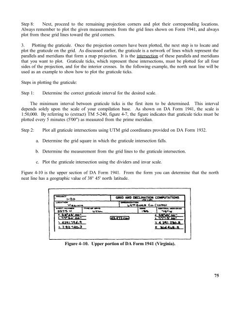
Step 8: Next, proceed to the remaining projection corners and plot their corresponding locations.Always remember to plot the given measurements from the grid lines shown on Form 1941, and alwaysplot from these grid lines toward the grid corners.3. Plotting the graticule. Once the projection corners have been plotted, the next step is to locate andplot the graticule on the grid. As discussed earlier, the graticule is a network of lines which represent theparallels and meridians that form a map projection. It is the intersection of these parallels and meridiansthat you want to plot. Graticule ticks, which represent these intersections, must be plotted for all foursides of the projection, and for the interior crosses. In the following example, the north neat line will beused as an example to show how to plot the graticule ticks.Steps in plotting the graticule:Step 1:Determine the correct graticule interval for the desired scale.The minimum interval between graticule ticks is the first item to be determined. This intervaldepends solely upon the scale of your compilation base. As shown on DA Form 1941, the scale is1:50,000. By referring to (extract) TM 5-240, figure 4-7, the figure indicates that graticule ticks must beplotted every 5 minutes (5'00") as measured from the prime meridian.Step 2: Plot all graticule intersections using UTM grid coordinates provided on DA Form 1932.a. Determine the grid square in which the graticule intersection falls.b. Determine the measurement from the grid lines to the graticule intersection.c. Plot the graticule intersection using the dividers and invar scale.Figure 4-10 is the upper section of DA Form 1941. From the form you can determine that the northneat line has a geographic value of 38° 45' north latitude.Figure 4-10. Upper portion of DA Form 1941 (Virginia).75