New Powerful Signal Processing and Radar MappingFR-<strong>21</strong>05 series X-band radarsFR-<strong>21</strong>15: X-band, 12 kW, TR upFR-<strong>21</strong>25: X-band, 25 kW, TR upFR-<strong>21</strong>55: X-band, 50 kW, TR upPhoto:6.5 ft antenna unitThe new rugged cast aluminumantenna gearbox is based onmany years of design experience.The new streamlined stylishradiators come in various sizesand are available in 24 rpmstandard or 42 rpm optional (onlyfor FR-<strong>21</strong>15/<strong>21</strong>25).Complies with the followingRegulations and Standards:● IEC 60936-1 Shipborne radar● IEC 60936-2 HSC radar● IEC 60872-1 ARPA (withoptional ARP-26)● IEC 60872-3 EPA● IEC 60945 Generalrequirements● IMO MSC.64(67) Annex 4● IMO A.823 (19)The FR-<strong>21</strong>15/<strong>21</strong>25/<strong>21</strong>55are designed for a widerange of users such ascoasters, fishing boats,mega yachts, cargo andpassenger ships, alsohigh-speed craft or anyone requiring a highresolution,high-refresh rate display in multi-<strong>color</strong>rasterscan.The equipment is available in a variety ofconfigurations: 12, 25 or 50 kW output, short or longantenna radiator, 24 or 42 rpm scanner, with standardelectronic plotting facility and optional AutomaticRadar Plotting Aid (ARPA). These plotting aids areessential in shipborne radar to reduce the workloadof ship personnel and to improve the standard ofcollision avoidance.The display unit employs a <strong>21</strong>" high-resolution multi<strong>color</strong>monitor which provides an effective diameter of275 mm. Radar echoes are presented in a selected<strong>color</strong> with a day or night background <strong>color</strong> for easyobservation under all lighting conditions. Different<strong>color</strong>s are assigned for marks, symbols and texts foruser-friendly operation.The control head haslogically arranged controlsin a combination of pushkeys, rotary controls and awell-organized menustructure, and can be separated from the display unitvia a flexible cable. The display pedestal contains allmajor modules and may be separated from themonitor part.Operational features include all functions required bythe IMO and IEC, such as, Head-up/Course-up/North-up orientation, parallel index lines, True Motion,sensor status message for compass, SDME, GPSand other electronic position-fixing systems, windparameters, depth sounder data, etc. interfaced inIEC 61162.Other features include two VRMs, range marker onthe EBL, two EBLs with capability of offcentering andinstant flipback, custom macro keys, multiplepulselengths, storage of operator-created maps,optional chart cards and the RP-26 Video Plottermodule.
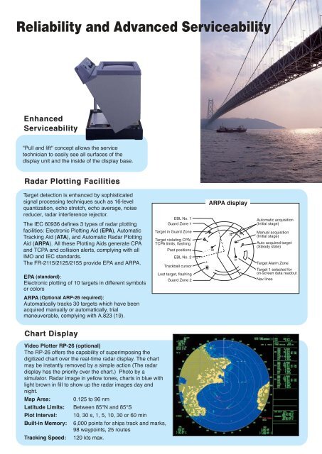
Reliability and Advanced ServiceabilityEnhancedServiceability"Pull and lift" concept allows the servicetechnician to easily see all surfaces of thedisplay unit and the inside of the display base.Radar Plotting FacilitiesTarget detection is enhanced by sophisticatedsignal processing techniques such as 16-levelquantization, echo stretch, echo average, noisereducer, radar interference rejector.The IEC 60936 defines 3 types of radar plottingfacilities: Electronic Plotting Aid (EPA), AutomaticTracking Aid (ATA), and Automatic Radar PlottingAid (ARPA). All these Plotting Aids generate CPAand TCPA and collision alerts, complying with allIMO and IEC standards.The FR-<strong>21</strong>15/<strong>21</strong>25/<strong>21</strong>55 provide EPA and ARPA.EPA (standard):Electronic plotting of 10 targets in different symbolsor <strong>color</strong>sEBL No. 1Guard Zone 1Target in Guard ZoneTarget violating CPA/TCPA limits, flashingPast positionsEBL No. 2Trackball cursorLost target, flashingGuard Zone 2ARPA display0201+Automatic acquisition(Initial stage)Manual acquisition(Initial stage)Auto acquired target(Steady state)Target Alarm ZoneTarget 1 selected foron-screen data readoutNav linesARPA (Optional ARP-26 required):Automatically tracks 30 targets which have beenacquired manually or automatically, trialmaneuverable, complying with A.823 (19).Chart DisplayVideo Plotter RP-26 (optional)The RP-26 offers the capability of superimposing thedigitized chart over the real-time radar display. The chartmay be instantly removed by a simple action (The radardisplay has the priority over the chart.) Photo by asimulator. Radar image in yellow tones, charts in blue withlight brown in fill to show up the radar images day andnight.Map Area: 0.125 to 96 nmLatitude Limits: Between 85°N and 85°SPlot Interval: 10, 30 s, 1, 5, 10, 30 or 60 minBuilt-in Memory:Tracking Speed:6,000 points for ships track and marks,98 waypoints, 25 routes120 kts max.