<strong>Sepulveda</strong> <strong>Dam</strong> <strong>Basin</strong><strong>Master</strong> <strong>Plan</strong> and Environmental Assessment2.2.2 Operational IssuesDue to the urbanized nature of the watershed, the runoff response to rainfall is rapid withtypically high peak discharges of relatively short duration. With the intensive use of the <strong>Basin</strong> forrecreation and for transportation corridors (e.g., Burbank Boulevard and Woodley Avenue),Project inflows require that affected agencies and the public be given sufficient advance warningto minimize potential flood impacts and to ensure public safety. The trash rack in front of theoutlet works occasionally becomes clogged from vegetative debris and trash accumulation thatmust be manually cleared. The lower portion of the trash-rack has been permanently removed toprevent trash buildup that would affect the capability of the <strong>Dam</strong> to make scheduled releases offlood waters.The City of <strong>Los</strong> <strong>Angeles</strong> Bureau of Sanitation’s, Donald C. Water Reclamation <strong>Plan</strong>t (TWRP) islocated within the <strong>Basin</strong>. A floodwall surrounding the TWRP protects the plant from inundationup to the one-percent chance exceedance event which is estimated as elevation 712 feet NGVD(Corps 1989). At higher water surface elevations, inundation of the treatment plant would resultin contamination of surface waters from untreated or partially treated wastewater sewage.Continued increase of the water surface elevation will result in plant shut down and diversion ofuntreated sewage to the <strong>Los</strong> <strong>Angeles</strong> Hyperion Treatment <strong>Plan</strong>t in Playa del Rey.2.3 Real EstateThe Corps acquired a total of 2,131.9 acres in fee for construction, operations, and maintenanceof the Project. Of the total acreage, the Corps reserves 313.0 acres, including 157.8 acres ofroads, exclusively for operation of the <strong>Dam</strong>.The City of <strong>Los</strong> <strong>Angeles</strong> (City) was granted a 50-year lease, effective 11 June 1951 through 10June 2001, to develop 2,000 acres in the <strong>Basin</strong> for park and recreational purposes. Over time, thelease has been supplemented several times resulting in a total reduction of the acreage to1,526.80 acres more or less. The term was extended to expire on 4 January 2042. Presently, twoamendments are pending execution, which authorize construction of the <strong>Sepulveda</strong> SportsComplex and transfer of the Encino Park and Ride to the City of <strong>Los</strong> <strong>Angeles</strong>, Department ofTransportation. The total acreage after execution of the outstanding amendments is 1586.86acres more or less.In 1954, a lease was granted to the West Valley Youth, Inc., a California nonprofit corporation todevelop 5.5 acres as a baseball park for children. In 1979, the lease was modified and granted toFranklin Field, Inc., a California nonprofit corporation which increased the amount of leasedland from 5.5 acres to approximately 28 acres and extended the term by 25 years to 2004. On 19March 2003, a new lease was granted to Franklin Field, Inc., now Encino Franklin Field, Inc., for22 years to run from 1January 2003 to 31 December 2025. See Map 4.Additionally, several leases have been granted in the <strong>Sepulveda</strong> <strong>Basin</strong> for non-recreationalpurposes, which include: a lease for 96.59 acres to the City of <strong>Los</strong> <strong>Angeles</strong> Bureau of Sanitationfor the Donald C. Tillman Water Reclamation <strong>Plan</strong>t; 10.53 acres to the City of <strong>Los</strong> <strong>Angeles</strong>Department of Public Works for a fire station; and a lease for 6 acres to the state of California forProject Description 2-6
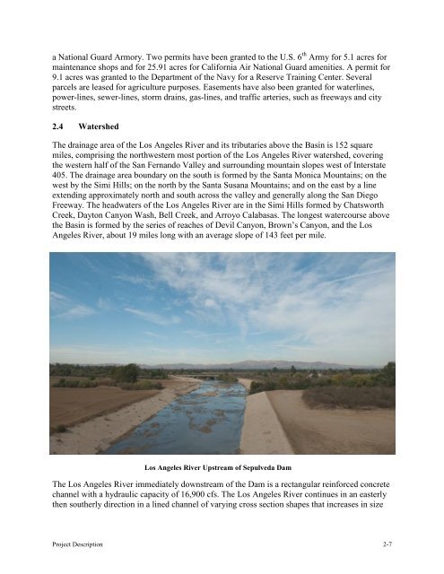
a National Guard Armory. Two permits have been granted to the U.S. 6 th <strong>Army</strong> for 5.1 acres formaintenance shops and for 25.91 acres for California Air National Guard amenities. A permit for9.1 acres was granted to the Department of the Navy for a Reserve Training Center. Severalparcels are leased for agriculture purposes. Easements have also been granted for waterlines,power-lines, sewer-lines, storm drains, gas-lines, and traffic arteries, such as freeways and citystreets.2.4 WatershedThe drainage area of the <strong>Los</strong> <strong>Angeles</strong> River and its tributaries above the <strong>Basin</strong> is 152 squaremiles, comprising the northwestern most portion of the <strong>Los</strong> <strong>Angeles</strong> River watershed, coveringthe western half of the San Fernando Valley and surrounding mountain slopes west of Interstate405. The drainage area boundary on the south is formed by the Santa Monica Mountains; on thewest by the Simi Hills; on the north by the Santa Susana Mountains; and on the east by a lineextending approximately north and south across the valley and generally along the San DiegoFreeway. The headwaters of the <strong>Los</strong> <strong>Angeles</strong> River are in the Simi Hills formed by ChatsworthCreek, Dayton Canyon Wash, Bell Creek, and Arroyo Calabasas. The longest watercourse abovethe <strong>Basin</strong> is formed by the series of reaches of Devil Canyon, Brown’s Canyon, and the <strong>Los</strong><strong>Angeles</strong> River, about 19 miles long with an average slope of 143 feet per mile.<strong>Los</strong> <strong>Angeles</strong> River Upstream of <strong>Sepulveda</strong> <strong>Dam</strong>The <strong>Los</strong> <strong>Angeles</strong> River immediately downstream of the <strong>Dam</strong> is a rectangular reinforced concretechannel with a hydraulic capacity of 16,900 cfs. The <strong>Los</strong> <strong>Angeles</strong> River continues in an easterlythen southerly direction in a lined channel of varying cross section shapes that increases in sizeProject Description 2-7