

Summary Paper – Northern Sector - Western Australian Planning ...
Summary Paper – Northern Sector - Western Australian Planning ...
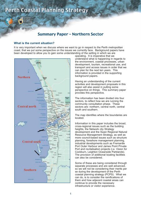
Summary Paper – Northern Sector - Western Australian Planning ...

Create successful ePaper yourself
Turn your PDF publications into a flip-book with our unique Google optimized e-Paper software.
The department is in the early stages of a study to determine the need for new and upgradedrecreational boating facilities along the metropolitan coast to serve the growing population of thePerth. It is anticipated that several major new boating facilities will be needed over the next 20years.Fremantle – Rockingham Industrial Areas Regional Strategy (FRIARS)(2000)The Fremantle – Rockingham Industrial Area was the subject of a study into strategic land useplanning for the region over the next 20 – 25 years. The final report “Fremantle – RockinghamIndustrial Area Regional Strategy” (2000), (FRIARS) was the culmination of extensiveinvestigations into the issues and redevelopment opportunities for the Fremantle – Rockinghamregion. The main planning issues it addressed were:◆◆◆◆◆◆◆existing and potential land use conflicts between industrial and other land uses;the protection of the Kwinana Industrial Area (KIA) and preservation of opportunities forheavy industry and port facilities in the region;the future role of the Kwinana Environmental Protection Policy (EPP) buffer as a land useplanning and environmental management tool;protection of environmentally significant features in the region including Cockburn Sound;provision of employment opportunities;identification of land appropriate for general industrial development; andcertainty for residents in the region by recommending a clear plan and time frame forredevelopment.The strategy is premised on the need to protect and optimise the KIA. It allows the governmentto initiate land use changes within the buffer area by removing potential conflicts and creatingopportunities to meet the demands of industry. Environmental and land use planning is toconsider the importance of the KIA to the state’s economy and facilitate its optimisation.There are major implications for current coastal uses and future community desires regardingcoastal recreational, tourism and commercial facilities along this entire stretch of coast. There isno direction provided in the FRIARS as to what access will remain along the coast. Thepreferred option for land use within FRIARS is for the redevelopment of Kwinana EPP buffersolely for industrial purposes. All residential developments in Naval Base, Hope Vallet andWattleup would be acquired over time along with rural developments. This has implications as towhere tourism and recreation will be requiring services in the future. Current comments suggestthere is a lack of recreational beach facilities in this region.Draft ministerial taskforce Report: Tourist AccommodationIn late 2002, the Minister for <strong>Planning</strong> and Infrastructure established a taskforce to examineissues surrounding the trends of introducing residential components to tourist developments ontourist zoned land and the strata titling of tourist developments. The Minister had noted a lack ofstrategic policy to guide planning authorities in dealing with such proposals, and that thedevelopment of this required investigation of potential impacts generally, and on:◆the maintenance of a high level of accessibility of prime recreation areas by the generalpopulation,5
Surf life saving clubsCurrently, surf life saving facilities can be found at the following beaches:- Yanchep- Quinns Mindarie- Mullaloo Beach- Sorrento- Trigg Beach- Scarborough- Floreat Beach- City Beach (City of Perth)- Swanbourne- North Cottesloe Beach- Cottesloe Beach- Leighton (Fremantle)- Port Beach- Coogee Beach- Secret HarbourSurf Life Saving WA have in the process of developing the 2020 plan, which will identify gaps infacilities and highlight the need for new facilities.Swan Catchment CouncilThe Swan Regional Strategy for Natural Resource Management was recently endorsed by Stateand Commonwealth government Ministers and the Council is now finalising and implementingtheir investment plan. As part of this plan, funds being allocated to either continue or commencevarious natural resource management projects.From the coastal and marine regional delivery program, projects are:1. Identifying key indicators – developing and implementing a scientific methodology toidentify key indicator species for the protection and conservation of viable population ofmarine fauna.2. Beach health.Completed projects are:◆ Marine and Coastal Natural Resource Inventory (2004)◆ Distribution of Major Marine Fauna found in the Perth Metropolitan Area (Yanchep toMandurah) (2005).From the Indigenous regional delivery program, projects are:1. The Swan Catchment Council has already produced a CD that tells the creation story ofthe south-west of <strong>Western</strong> Australia that is told by Noel Nannup. There is also more storiesto be recorded that show the intimate relationship and respect to the land.7
2. The Swan Catchment Council has also been involved in negotiating an Indigenousland-care trainee-ship with multiple stakeholders that will be involved in the strategiesregional delivery program.3. The Swan Catchment Council has also submitted a cross-regional proposal based onraising the profile on Indigenous sites within regions. This will be achieved by full heritagemanagement plans and added to them will be the inclusion of stories to each site.8
<strong>Northern</strong> <strong>Sector</strong>This sector encompasses the City of Wanneroo and part of the City of Joondalup, north of thedevelopment front at Burns Beach. It is fundamentally the undeveloped north.City of WannerooThe City of Wanneroo adopted the Mindarie - Quinns Rocks Foreshore Management Plan inJune 2004. This plan was prepared as a result of a review of the Mindarie Beach ForeshoreReserve Management Plan that was adopted by the Council in 1994. The Quinns Beach EstateForeshore Management Plan has been implemented by the developer.A summary on the structure plans within the Wanneroo area:Mindarie Keys Finally adopted by WAPC 3.11.98Mindarie Keys Harbourside Village Finally adopted by WAPC 25.1.00Alkimos-EglingtonNo formal application recordedYanchep South Finally adopted by WAPC 10.3.05Two Rocks <strong>Northern</strong> Precinct LSP Finally adopted by WAPC 26.10.04Lot 8989 Two Rocks Road Two Rocks Tribunal Appeal No. 186 of 2003Lot 201 Breakwater Drive, Two Rocks Finally adopted by WAPC 15.10.02Lot 12 Marmion Avenue, Jindalee Finally adopted by WAPC 18.11.03Butler-Jindalee District Structure PlanLot 102 Marmion Avenue, Yanchep26 April 2005 Council Meeting(also initiates Amendment 57 to DPS2)Swan Loc 13460, Yanchep Beach Road, Yanchep Finally adopted by WAPC 10.2.04Yanchep Two Rocks DSPWithdrawnYanchep Capricorn Village LSPDocs with WAPCLot 501 Two Rocks Road, Two Rocks Adopted by WAPC 2.6.05At Quinns Beach, chronic erosion and associated foreshore recession has previously threatenedroads and carparks. Investigations have been completed as well as foreshore stabilisation works(groynes and nourishment) in 2003/04 by the City of Wanneroo.In the City of Wanneroo there is a major problem with weed build-up south of the Two Rocks boatharbour and erosion of the beaches north of the harbour. A physical modelling study and erosionstudy has been completed to develop options for management. Permanent works will depend ona proposed harbour structure plan.It still would be desirable for the City of Wanneroo to pursue the development of a local coastalstrategy / coastal management plan, which would draw together a number of site developmentplans and provide overall guidance to the local government across its entire coastline. Councilare currently discussing this issue with some of the larger landowners / developers.Currently the City is reviewing the Two Rocks Yanchep Foreshore Management Plan and the Lot614 Yanchep Foreshore Management Plan that were adopted by the Council in 1997. The reviewcombines both Foreshore Management Plans into one plan and also includes the draft CapricornCoastal Village Foreshore Management Plan prepared by Tokyu Corporation for the foreshore9
abutting the Capricorn Coastal Village Structure Plan area. Council considered this draft planduring April/May 2005 for the purpose of advertising it for public comments. Other managementplans developed in the mid nineties are also under review.In respect to boating facilities, Council recognises that the demand for public boat launchingfacilities, in the medium to long term, is likely to exceed the 160-bay capacity provided at theMindarie Marina. It will be seeking the views of private developers in the area regarding provisionof a public boat launching facility, and their willingness to participate. Council has endorsed theconcept of a feasibility study into a public boat launching facility in the area north of QuinnsRocks, namely the Jindalee, Alkimos, and Eglinton regions.City of JoondalupThe Joondalup Coastal Foreshore Natural Areas Management Plan is currently beingimplemented with $150 000 allocated to undertake fencing, weed control and planting of nativespecies.The City is continuing with the Adopt-A-Coastline environmental program with local schools. Over3000 children from 16 schools have been involved in coastal bushland regeneration projects inJoondalup in the last 5 years.The city has also been busy completing the first stage of the Sorrento beach redevelopment withthe second stage due to commence in the new financial year.<strong>Planning</strong> activitiesSt Andrews District Concept PlanThe St Andrews project is located around Yanchep and Two Rocks. Tokyu Corporation (Tokyu)own 4132 ha of land within the Project Area. The City of Wanneroo and Tokyu are parties to theSaint Andrews Strategic Cooperation Agreement (SCA) with the State Government of WA (1999)which recognise the benefits to be gained through the cooperation with a landowner in theprovision and development of a significant amount of urban land.The City and Tokyu have now recognised the cooperation framework through a Memorandum ofUnderstanding (MoU). This MoU is an in principle agreement describing joint initiatives andcooperation between the parties, and foreshadows future projects and actions related to thedevelopment and to the local community.Tokyu submitted to both the City of Wanneroo and to the State Government in late 2004, the StAndrews Concept Plan as the first stage in the District Structure planning process. This plan willbe supplemented where required with additional information sufficient for the City to make anappropriate level of assessment and determination.The Ccncept plan will lead directly to the preparation of a District Structure Plan andamendments to the MRS. The plan has been lodged with the City of Wanneroo and is nearrelease for public advertising. A requirement of the plan is that it will provide opportunities for lowcost beachfront camping and caravan parks.Through continued collaboration and engagement with the local community, service agencies,business and government, Tokyu plans to progress the guiding principles underpinning the districtstructure planning process.10
Capricorn Village Structure PlanThis structure plan is in its initial stages in respect to determining its broad urban design. Apreliminary general land use plan for the area outlines where the coastal node will be located, itsfunction and links to adjacent land uses. One requirement of the Commission’s approval of thelocal structure plan for Capricorn Village is that the district structure plan, which will follow thedistrict concept plan currently on exhibition, must provide opportunities for low cost beach frontcamping and caravan parks.Jindee Structure PlanPlease note – this map is indicative only and should not be relied upon.Local Structure Plans may change over time and as this is a 15 year development,could change to reflect this.As a demonstration project, Jindee is seeking to improve the community environment byincorporating the prime objectives from Liveable Neighbourhoods, smart growth and thesustainability agenda. It is not being driven by overlays of existing codes and regulations.Jindalee Structure Plan (Lot 12)The structure plan was adopted by the City of Wanneroo on 18 November 2003. The structureplan is to be subjected to minor amendments before being adopted by the WAPC. A ForeshoreManagement Plan for the foreshore area abutting the structure plan area was required at thattime, as was the drainage management strategy. Substantial beachfront reserve is provided for,with three beach activity centres. The largest will be Jindee, which is located at the bestswimming beach. Local structure planning for Jindee and discussions on the nature and extent ofthe beachfront activity centre are progressing with City of Wanneroo and WAPC.The development front is currently approximately half way through the Butler Jindalee districtstructure plan.Alkimos-Eglinton Structure PlanThe previous district structure plan was not endorsed by the WAPC. Significant review in 2004has lead to preparation of a district concept plan, which has the support of all stakeholders andinterested government agencies. The consortium of landowners is in the process of selecting aplanning team to develop the district concept plan into a district structure plan over the remainderof 2005 and 2006.11
Urban development in this area is not anticipated until 2008 at the earliest.Three beachfront activity centres are shown on the district concept plan: at the southern end ofAlkimos beach, the northern end of Alkimos beach and Eglington marina at the end of PipidinnyRoad. In all cases, these centres connect back by relatively direct roads to railway stations on thefuture Clarkson to Yanchep railway line.As a result of a submission from The Combined Swan River and Swan Coastal Plains NativeTitle Claimants, DPI is investigating how the WAPC may better provide opportunity for the earlyinvolvement of the indigenous community in these planning processes.Burns Beach Structure PlanThe 291 hectare land parcel was acquired by the Burns Beach Trust in 1969 and incorporatedthe adjacent suburb of Kinross, which has already been developed for residential purposes. Thesite is bounded by a Parks and Recreation Reservation to the north, the Indian Ocean to thewest, Marmion Avenue to the east and Burn Beach Road to the south. The site is currentlyvegetated vacant land that is traversed by numerous informal four wheel drive tracks.The plan has considered sustainability from all perspectives to ensure a community with socialdiversity. It embraces many Liveable Neighbourhood principles such as “walkability” and“permeability”, which contribute to reducing car use, creating a greater sense of community,better access to services and using land more efficiently.The Burn Beach Structure Plan was approved for advertising by the City of Joondalup in Nov2004, with advertising closing December 2004. The developers, Peet and Co. are currentlyfinalising the foreshore management plan. This plan is to provide a practical and prescriptiveframework to restore, rehabilitate and provide controlled access and recreation within theforeshore at Burns Beach.A coastal node plan has been developed and endorsed by the community reference group.Industrial developmentsThe Alkimos Project (Source: Water Corporation website 2005)The population growth of Perth’s north-west corridor from Mindarie northwards is predicted togrow to about 150,000 by the year 2030. As well as residential growth, it is expected that thesuburb of Alkimos will develop into a regional centre for commerce and education, with thepotential for a regional hospital, university/TAFE facilities, and police, justice and emergency services. Well-planned infrastructure will be required to support the predicted growth of the northwestcorridor. The Water Corporation’s role is to work with all stakeholders to provide state-ofthe-artwater and wastewater services.The project has the following interrelated key elements:◆◆◆◆◆a wastewater treatment planta possible water recycling schemean ocean outletmain sewers to transport raw wastewater to the planta drinking water treatment plant.12


