8 November 2006 - Independence Group NL
8 November 2006 - Independence Group NL
8 November 2006 - Independence Group NL

Create successful ePaper yourself
Turn your PDF publications into a flip-book with our unique Google optimized e-Paper software.
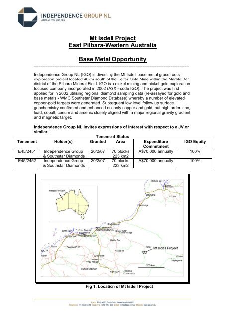
Mt Isdell ProjectEast Pilbara-Western AustraliaBase Metal Opportunity___________________________________________________________________<strong>Independence</strong> <strong>Group</strong> <strong>NL</strong> (IGO) is divesting the Mt Isdell base metal grass rootsexploration project located 40km south of the Telfer Gold Mine within the Marble Bardistrict of the Pilbara Mineral Field. IGO is a nickel mining and nickel-gold explorationfocused company incorporated in 2002 (ASX - code IGO). The project was firstapplied for in 2002 utilising regional diamond sampling data (re-assayed for gold andbase metals - WMC Southstar Diamond Database) whereby a number of elevatedcopper-gold targets were generated. Subsequent low level follow up surfacegeochemistry confirmed and enhanced not only copper and gold, but high order zinc,lead, cobalt, cerium and arsenic closely aligned with a major regional gravity gradientand magnetic target.<strong>Independence</strong> <strong>Group</strong> <strong>NL</strong> invites expressions of interest with respect to a JV orsimilar.Tenement StatusTenement Holder(s) Granted Area Expenditure IGO EquityCommitmentE45/2451 <strong>Independence</strong> <strong>Group</strong> 20/2/07 70 blocks A$70,000 annually 100%& Southstar DiamondsE45/2452 <strong>Independence</strong> <strong>Group</strong>& Southstar Diamonds223 km220/2/07 70 blocks223 km2A$70,000 annually 100%Fig 1. Location of Mt Isdell Project
Fig 2. Regional Geology with Known Deposits and ProspectsGeology and StructureThe Mt Isdell Project area is predominantly underlain by shallow northeast dipping pyriticto carbonaceous shale, thin bedded limestone, marl and siltstone of the LamilFormation/Isdell <strong>Group</strong> within the Yeneena Basin (Neoproterozoic). Underlying (either adisconformity or tectonic contact) the shale dominated formation, is a sequence ofmicaceous siltstone with sandstone and interbedded shale horizons, thought to either bea lower arenaceous section of the Isdell Formation or the equivalent BroadhurstFormation (a similar thicker sequence of rocks separated from the Isdell Formation bythe Camel - Tabletop Fault Zone to the west). A mafic to ultramafic dyke/sill suite haspreferentially intruded the arenaceous rocks close to and generally east of the northwesttrending Camel - Tabletop fault structure (refer to Figures 3 and 4). Small granite tomonzo-granite bodies also intrude along the same general trend. The intrusive rocks arelikely a part of the 650 Ma granite complex associated with the Telfer Dome and otherdomes further north of the project area. Permian tillites cover the northern portion of theproject area.Previous ExplorationOver a period of 35 years, a number of commodities have been targeted ranging fromuranium exploration focused on basal rudite/arenite/metamorphic units, base metalexploration targeting Nifty (Cu), Maroochydore (Cu, Co) and Warrabarty (Zn) style
mineralisation and gold exploration looking at domical/anticlinal (Telfer look-alike)positions and shear hosted/vein mineralisation. Figure 5 highlights the extent of open filedrilling. Note, the majority of the drilling is shallow regolith style designed to penetratethe extensive sand cover. Previous regional surface geochemistry (soil) was restricted towide spaced BLEG sampling (gold exploration) and localised soil grids over specifictargets (geophysical, reconnaissance surface sampling and geological mapping).Recent WorkRegional aeromagnetic and gravity surveys completed in <strong>2006</strong> (government surveys)have greatly enhanced the potential of the Mt Isdell Project (Figures 3 and 4). In additionto the magnetics delineating significant mafic/ultramafic intrusive bodies of unknown ageclosely associated with the regional Camel -Tabletop fault zone, a number of northtrending shear structures occur as splays which transgress strong chemically reactiverocks over distance of >10km. Recent field work has confirmed north trendinggossanous shears within limited shale outcrop having significant rock chip anomalism.Values include Pb to 2%, Zn to 2600ppm, Sb to 108ppm, As to 836ppm and Au to68ppb.Regional and subsequent infill lag sampling completed by IGO has defined high orderZn/Pb surface anomalism that has not been drill tested (Main Target). The anomalismappears to be associated with the main lithological trend hosting the Maroochydoredeposit and north trending structures. Over an area 3km by 2km within sand dunes, Znhas returned up to 3259ppm with numerous sample sites >1000ppm Zn. In thesame area Pb has returned up to 1730ppm, Cu to 761ppm, Co to 515ppm, Ce to1204ppm, As to 734ppm and Au to 51.7ppb. Figures 7 and <strong>Group</strong> 9 highlight theanomalism.The Main Target anomalism (see figure 7) is overlain by the Permian cover to the westand the main anomalous multi-element trend is open under sand cover to the ESEtowards the Maroochydore deposit. Note figure 8 presents the extent of sand cover overthe Mt Isdell Project.PotentialThe Mt Isdell Project is considered prospective for a range of mineralisation styles.• Stratabound clastic sediment hosted structurally controlled Nifty style epigeneticcopper (lead-zinc-silver-nickel-cobalt) mineralisation. Nifty has a resource of39Mt @ 2.5 % Cu and is open down plunge. The Maroochydore Cu-Co deposit isconsidered similar to Nifty.• Stratiform/stratabound vertically stacked/stock-worked quartz-carbonate sulfidegold-copper vein sets (Telfer-style) mineralisation. The Telfer resource is over25Moz Au and nearly 1Mt copper.• High grade zinc high angle fault breccia Warrabarty-style deposits.• The extensive mafic/ultramafic suite associated with the Camel-Tabletop faultzone may have similarities to the known PGE bearing ultramafics within theRudall Complex further south.Expression of InterestFor all enquiries for further information (Mt Isdell Project ) please contact the following.Tim Kennedy - Exploration Manager (tkennedy@igo.com.au) - phone 0893672755Brett Keillor - Principal Geologist - Gold Projects (bkeillor@igo.com.au)
Fig 3. Regional Total Magnetic Intensity Image - Mt Isdell ProjectFig 4. Regional Residual Gravity Image - Mt Isdell Project
Fig 5. Location of Historical Drilling over TMI ImageFig 6. Solid Geology Interpretation - Mt Isdell Project
Fig 7. Geochemistry Targets and Factual GeologyFig 8. Landsat ETM Image and Targets - Mt Isdell Project
Zn/Fe GeochemistryPb/Fe GeochemistryCo/Fe GeochemistryCu/Fe GeochemistryCe/Fe GeochemistryAu/Fe Geochemistry<strong>Group</strong> Fig 9. Lag Geochemistry (normalised to Fe) Mt Isdell ProjectBrett Keillor12th March 2007