TAG - Geological Society of Australia
TAG - Geological Society of Australia
TAG - Geological Society of Australia

Create successful ePaper yourself
Turn your PDF publications into a flip-book with our unique Google optimized e-Paper software.
The <strong>Geological</strong> <strong>Society</strong><strong>of</strong> <strong>Australia</strong> IncNewsletter Number 160September 2011tagLaying the foundationsee p24Young EarthScientists up closesee p28Honouring Ernie NickelNew Geochemical Atlas &Mineral Exploration<strong>Australia</strong>n Geoscience TertiaryEducation Pr<strong>of</strong>ile
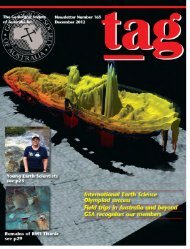
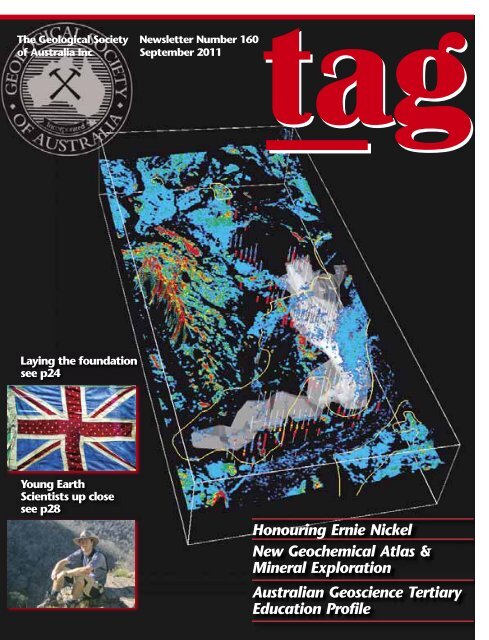
The <strong>Australia</strong>n GeologistNewsletter 160, September 2011Registered by <strong>Australia</strong> PostPublication No. PP243459/00091ISSN 0312 4711Managing Editor Sue FletcherTechnical Editor Bill BirchSend contributions to tag@gsa.org.auCentral Business OfficeExecutive Director Sue FletcherSuite 61, 104 Bathurst Street,Sydney NSW 2000Telephone (02) 9290 2194Fax (02) 9290 2198Email info@gsa.org.auGSA website www.gsa.org.auDesign Alan Taylor, The Visible Word Pty LtdTypesetting Joan Taylor, The Visible Word Pty LtdPrinted by Ligare Pty LtdDistributed by Trade Mailing & Fulfilment Pty LtdLaying the Foundation p24Early <strong>Australia</strong>n Earth Scientists inthe Antarctic: Part 1.Essay Review p30Jon Hronsky reviews A guide formineral exploration through theregolith in the Yilgarn Craton, WA(AJES Vol 57; No.8).Feature: New NationalGeochemical Atlas p32Patrice De Caritat on fresh avenuesfor mineral exploration and naturalresource management.F R O N TC O V E RA seamless 3D mineral map <strong>of</strong>‘kaolin disorder’ generated from bothairborne (draped over a DEM surface)and drill core (vertical white strings)hyperspectral data together with ashell (grey volume) generated fromX-ray fluorescence Fe2O3 contentas well as the vector outlines (orangelines) <strong>of</strong> the ‘Robe pisolites’ (channeliron ore – CID) from in the published100K Rocklea geological map sheet.The CID and other transportedmaterials are characterised by poorlyordered kaolin (blue tones) whereasin situ weathered bedrock compriseswell-ordered kaolin (red tones) thatin places cuts across the publishedmapping and marks the boundary <strong>of</strong>the Rocklea CID deposit. Generatedby the WA Centre <strong>of</strong> Excellence for3D Mineral Mapping (C3DMM –http://c3dmm.csiro.au).22 From the President23 <strong>Society</strong> UpdateBusiness Report2 Membership FeesLetters to the EditorFrom the AJES Editor’s DeskEducation & OutreachStratigraphic ColumnHeritage Matters15 News from the Divisions18 News from the Specialist Groups20 News28 Young Earth Science News34 Special Report: Geoscience Education37 Special Issue <strong>of</strong> AJES40 Cam Bryan’s Geojottings42 Book Reviews44 Obituaries46 Calendar47 Office Bearers48 Publishing Details
From the PresidentAt the time <strong>of</strong> writing this column, I am in Bern,Switzerland, attending the XIIIth Congress <strong>of</strong> theInternational Union for Quaternary Research (INQUA).Bern is not a large city (about 130 000 people) and an influx <strong>of</strong>more than 2000 Quaternary scientists has severely tested localaccommodation. Nevertheless, it has been a most successfulconference and I have enjoyed meeting old friends, makingnew ones, and learning many new things.Not surprisingly, many <strong>of</strong> the papers at INQUA have apaleoclimate focus. Indeed, the famous 800 000-year carbondioxide record from the EPICA Antarctic ice core was featuredas a sculpture in the entrance hall <strong>of</strong> the congress centre.However, Quaternary research is much more than paleoclimate— plenary talks ranged from the recent Japanese and NewZealand earthquakes to nuclear-waste disposal, while generalpapers included topics across a broad range <strong>of</strong> disciplines,including archaeology, geochronology, volcanology,geomorphology, palynology and hydrology, to name a few.The diversity <strong>of</strong> research presented at the INQUA congressis one <strong>of</strong> its strengths, in my opinion, and much the same couldbe said <strong>of</strong> the upcoming International <strong>Geological</strong> Congress inBrisbane next year. I well remember my first IGC, in Florence in2004 — not only was Florence a magnificent city to visit for the7 000 attendees, but the huge range <strong>of</strong> topics and sessions atthe conference <strong>of</strong>ten made it difficult to choose which ones togo to. GSA sponsors the IGC as one <strong>of</strong> the hosting societies <strong>of</strong>next years Brisbane IGC, and it will also double as our biennialconference, so I encourage all GSA members to attend. Checkthe congress website for further details at www.34igc.orgWhen I attend major international conferences like INQUAand IGC, which are held every four years, I feel like part <strong>of</strong> largefamily. However, there are Earth Science communities on manyscales — whether, through membership <strong>of</strong> a local Division orSpecialist Group <strong>of</strong> GSA or serving on an internationalcommittee, there are many career and personal benefits toactive participation in such communities.As you will read in this issue, there will be a modestincrease in GSA membership fees for most members over thenext three years. This is partly because, while the totalmembership <strong>of</strong> the society has remained fairly static, themembership demographic has changed, resulting in loweroverall income to the society from membership fees. I hopethat all <strong>of</strong> you will choose to remain as members <strong>of</strong> the GSAcommunity, despite the fee increase, and continue to benefitfrom the activities and publications <strong>of</strong> our society.One particular activity that Iencourage all members toparticipate in is outreach — we allrecognise the importance <strong>of</strong> EarthSciences to the <strong>Australia</strong>n economyand to understanding environmentalissues, but we need to ensure that members <strong>of</strong> thegeneral public, including school students and politicians, alsoappreciate this importance. The National Rock Garden projectis one such outreach activity, but there are many others.Recently, the GSA sent a letter to the Prime Minister, withcopies to the Minister for School Education, Early Childhood &Youth and to the Chief Government Scientist, expressingdismay at the government’s intention to cease funding for twoscience education programs being developed by the <strong>Australia</strong>nAcademy <strong>of</strong> Science, Primary Connections and Science byDoing. Both these acclaimed programs fit well with the new<strong>Australia</strong>n Curriculum for science that includes, for the firsttime, a national Year 11-12 Earth and Environmental Sciencestream. Not only do such programs increase public awareness<strong>of</strong> Earth Sciences, but they are vital to ensuring that there isflow <strong>of</strong> students through to university Earth Science programsthat ultimately will provide replacements for those <strong>of</strong> usapproaching retirement.BRAD PILLANSPresidentBrad Pillans standing behind the CO 2 curve for the last 800 000 years thatwas displayed at INQUA 2011.2 | <strong>TAG</strong> September 2011
<strong>Society</strong>UpdateBusiness ReportThe September issue <strong>of</strong> <strong>TAG</strong> brings you news aboutmany <strong>of</strong> the Division and Specialist Group activities, aswell the standing committees and local conferencesand symposia. We have more features and special reports thanusual and the Letters to the Editor are more than abundant.As always there is news about the National Rock Garden andwe showcase two Young Earth Scientists working in differentfields. Changes with accessing AJES online are included and JonHronsky discusses the importance <strong>of</strong> A guide for mineralexploration through the regolith in the Yilgarn Craton, Western<strong>Australia</strong> by Ravi Anand and Charles Butt, published in a recentissue <strong>of</strong> AJES (Vol 57; No. 8), and its relevance to explorationgeologists. Special thanks to Trevor Powell, former President <strong>of</strong>the <strong>Australia</strong>n Geoscience Council, for his comprehensive review<strong>of</strong> the council’s report on Geoscience Education at <strong>Australia</strong>nUniversities, which <strong>of</strong>fers hope for the future: “the situation <strong>of</strong>geoscience in <strong>Australia</strong>n universities is stronger now than at anytime over the past 15 years”.HEDG (Hunter Earth Sciences Discussion Group) has beenactive, with trips to vineyards to look at the soil and rocks (<strong>of</strong>course), as well as local talks at Newcastle University. TheQueensland Division held another highly successful booth atEkka, which is the annual agricultural show <strong>of</strong> Queensland. Thebooth is a collaborative effort with the GSA, AIG, theQueensland Museum and the <strong>Geological</strong> Survey <strong>of</strong> Queenslandworking together to promote Earth Sciences as a viableeducation path. The GSA provides hundreds <strong>of</strong> Fact-ites to giveaway to students. More news about this event will be includedin the December <strong>TAG</strong>.On the near horizon, upcoming GSA events include theSpecialist Group in Geochemistry, Mineralogy and Petrologybiennual conference to be held November 20-25 at theMurramarang Beachfront Nature Resort on the NSW southcoast — look for their advertisement in this issue <strong>of</strong> <strong>TAG</strong>. TheSpecialist Group in Tectonics and Structural Geologyconference is to be held 29 January – 3 February 2012 atWaratah Bay, Victoria. Also the annual South <strong>Australia</strong>Explorer’s Conference will take place on 2 December and do notforget the Sprigg Symposium on 1 December in Adelaide.This 1959 covercommemorated the opening <strong>of</strong>the Wilkes post <strong>of</strong>fice.The 2011-2012 Antarcticexpedition season marks 100 years<strong>of</strong> <strong>Australia</strong>n involvement inAntarctic research. Those goingsouth this season join a traditionestablished a century earlier by the first Australasian AntarcticExpedition (AAE) <strong>of</strong> 1911–14, led by Douglas Mawson. In theheroic age <strong>of</strong> Antarctic exploration, <strong>Australia</strong>ns were involvedin several expeditions. However, Mawson’s 1911–14 expeditionwas the first wholly <strong>Australia</strong>n undertaking. The AAE, togetherwith the 1929–1931 British, <strong>Australia</strong>n and New ZealandAntarctic Research Expedition (BANZARE) (also led byMawson), were important for establishing <strong>Australia</strong>'s claim forAntarctic territory. <strong>Australia</strong> has issued postage stamps for the<strong>Australia</strong>n Antarctic Territory since 1957.The first stamp issued specifically for the territory was atwo-shilling blue stamp with a design <strong>of</strong> explorers and anAntarctic map.In this and coming issues <strong>of</strong> <strong>TAG</strong> we will celebrate thecontribution made to <strong>Australia</strong>n Antarctic Expeditions. Pat Quiltywrites a two-part account <strong>of</strong> Early <strong>Australia</strong>n Earth Scientists inthe Antarctic in this and the next issue <strong>of</strong> <strong>TAG</strong> and some <strong>of</strong> thenumerous centenary activities are mentioned in this issue.The International <strong>Geological</strong> Congress is fast approachingand the GSA has booked many <strong>Society</strong> meetings, including theCouncil Meeting to be held on Sunday 4 August; the AnnualGeneral Meeting to be held on Monday 5 August, andnumerous meetings on Tuesday–Thursday nights. The GSA hassecured 20 discounted tickets and the first members to contactthe GSA and make payment will be given these tickets — see<strong>TAG</strong> pages 6 and 21 for more details.The GSA website has links to many conferences on thecalendar page: http://www.gsa.org.au/events/calendar.htmlSpecial thanks to Tony Cockbain and Bill Birch for editingthe September issue <strong>of</strong> The <strong>Australia</strong>n Geologist.By the time you receive this issue <strong>of</strong> <strong>TAG</strong> we will beapproaching the member renewal period, so if you have movedor changed any <strong>of</strong> your contact details or wish to add aSpecialist Group, now is the time to do so, please emailinfo@gsa.org.au or phone the <strong>of</strong>fice on 02 9290 2194.SUE FLETCHERExecutive Director<strong>TAG</strong> September 2011|3
New membersThe GSA welcomes the following new members to the <strong>Society</strong>.May you all have a long and beneficial association with the GSA:Lost membersThe following members mail has been returned to the GSA, asall their contact details are invalid. If you know them and havetheir contact details, please email: info@gsa.org.au or phonethe <strong>of</strong>fice on (02) 9290 2194 and assist us with locating them.Paolo AbballeRayhen AliPaul BannermanLianora Taralrud-BayTimothy BoddingtonKaylene CamutiTae Woo ChangOscar ClarkWilliam CollinsMatthew de PaoliTanya EwingBrendan GriffinAnna HaiblenAdam HardingMichael HawtinMark HockingHenry HunterTariqul IslamGeorge KatchanGemma LeeDouglas MackenzieSosthenes MassoloaFiona Davies McConchieIan MorrisonCheryl MortonBenjamin MoseyCelestine OgbonnaMatthew James PankhurstCatherine PritchardCameron QuinnSarah RitterJamie RobinsonSusannah Mary SageNikhilesh SenapatiPhilip SnowdenBrea StephenAntonio Tan, JrAndrew WelshMark WinsleyISSUE COPY FINISHED INSERTSARTDECEMBER 2011 26 Oct 2 Nov 9 NovMARCH 2012 28 Jan 3 Feb 2 MarJUNE 2012 30 Apr 4 May 29 MaySEPTEMBER 2012 30 Jul 6 Aug 18 AugACTM EMBERMasahiko HondaKeith ThomasMISCCatherine TaitNSWS TUDENTBenjamin DunlopDavid BamburyElias MartynErin FoateKarina JuddKristen ParmeterLei ZhaoEmma Louise JohnsonMichael EdwardsMorgan WrightOmar MohammadSharon JonesJoseph EmmiNTM EMBERAndrew ShortJoanne WhelanQLDM EMBERStephanie McRaeAdrian BernardChristine SheerinThomas LucasS TUDENTVictoria GallagherJessica AndersonGregory ClapinJohannes HammerliAdam GregoryG R A D U AT ENicholas CoulsonDanielle GeenenRachel WadeLaura AllenKrista InglisYvette HobbsCourtney TaylorEmma BlancoSAM EMBERSteven GaleS TUDENTCharlotte MitchellCatherine DisneyNaomi TuckerTASM EMBERMillard C<strong>of</strong>finS TUDENTAlistair HarveyPatrick MyerTom WrightJacqui RushLauren ThomasJesse CotterillMargaret EllisMatthew FergusonKevin HarrisLee HutchinsJack MulderNick SmithCraig WinterVICM EMBERRachel RobertsTrevor BlakeS TUDENTMatthew EdwardsZara DennisRoland SeubertG R A D U AT EKaren KapteinisWAM EMBERRichard HallS TUDENTRachael WoodA S S O C I AT ELarissa MacMillan4 | <strong>TAG</strong> September 2011
From the President and TreasurerIncreases to GSA Membership FeesDear GSA Member,Analysis <strong>of</strong> the <strong>Geological</strong> <strong>Society</strong> <strong>of</strong> <strong>Australia</strong>’s cashflow over thepast two years identifies operating cash losses for 2009 and2010. After the removal <strong>of</strong> income from investments and interestfrom the 2008 accounts, 2008 also has an operating cash loss.This is clearly not sustainable in the long-term.Over the same three-year period, membership has fluctuatedslightly from 2255 in 2008, to 2334 in 2009 and 2251 in 2010.However, due primarily to our aging demographic and anincreasing number <strong>of</strong> retired members, revenue from membershipfees has declined steadily over the same period, from $289 576in 2008, to $278 299 in 2009 and $266 562 in 2010.The GSA has not increased membership dues for at least fiveyears — current dues for all categories <strong>of</strong> membership are listedin Table 1, below.Category <strong>Australia</strong> International*Journal Journal No Journal Journal Nohard copy online Journal hard copy online Journalonly & online onlyMember $165 $150 0N/A $165 $150 0N/AMember $165 $150 0$90 $165 $150 0$90AssociateRetired 0$85 0$75 0$45 0$85 0$75 0$45MemberStudent 0$85 0$10 0$10 0$85 0$75 0$45Member (AJES)Student 0$20 0N/A 0N/A 0N/A 0N/A 0N/AMember (Alcheringa)Graduate 0N/A 0$88 0N/A 0N/A 0$88 0N/AMemberJoint 0N/A 0N/A 0$90 0N/A 0N/A 0$90MemberThe 2010 Audit <strong>of</strong> the GSA recommended a review <strong>of</strong>membership subscription fees. The recommended increase wasfrom $165pa to $220pa, for a normal membership, in order tosustain the <strong>Society</strong> financially. In response to thisrecommendation, the Executive considered the following factors:1. While accepting that we must move the <strong>Society</strong> to asustainable financial footing, the Executive feels that ourmembership will not respond positively to an immediateincrease to $220pa for full membership. A staged approach t<strong>of</strong>ee increases is therefore preferred.2. Our current agreement with Taylor and Francis specifies anannual charge to the GSA <strong>of</strong> $22 per member for hardcopy andelectronic subscriptions and $10 per member for electronic onlyaccess to AJES. This rate is subject to renegotiation if more than500 <strong>Society</strong> members elect to take electronic only access. Theagreement is valid until the end <strong>of</strong> 2013. Given the cost to the<strong>Society</strong> for paper and online AJES, the differential between fulland electronic-only memberships is appropriate. However, it isapparent that non-journal memberships for Retired andAssociate Members are heavily subsidised, when compared toAJES subscribers.3. Given that many <strong>of</strong> our retired members are able to claim atax rebate against Membership, it is our opinion that the ratecharged for this membership category is too low. A moreappropriate level would be ~70–75% <strong>of</strong> a full membership.4. The rate charged to Graduate Members is also heavilysubsidised, and should be reconsidered in a similar light to thatfor Retired Members.5. It is appropriate that the online AJES membership rate forstudents be maintained at $10, as this covers the cost <strong>of</strong> AJESto the society and we compete directly with AIG, who providefree student membership (but no journal).Following extensive, and at times passionate discussion, theExecutive reached the following points <strong>of</strong> consensus on GSA’sfuture fee structure:1. That the category <strong>of</strong> Graduate Membership be retained,pegged to the equivalent rate for Retired Members.2. That non-journal annual fees be increased, to a level <strong>of</strong>$10 beneath equivalent electronic journal annual fees, to moreaccurately represent the cost to the <strong>Society</strong>.3. That a 10% per annum increase be applied to Journalhardcopy annual fees for Members for each <strong>of</strong> the next threeyears and that a 30% increase be applied to Journal hardcopyannual fees for Retired Members and Students for each <strong>of</strong> thenext three years.4. That electronic journal and non-journal annual fees be set at$15 and $25 respectively below the ‘full’ rate for Members andRetired Members, where appropriate.5. That student electronic and non-journal annual fees remainat $10 per annum.The adoption <strong>of</strong> these principles mean that GSA’s membership feestructure for the next three years will be:2012Category <strong>Australia</strong> International*Journal Journal No Journal Journal Nohard copy online Journal hard copy online Journalonly & online onlyMember $182 $167 0N/A $182 $167 0N/AMember $182 $167 $157 $182 $167 $157AssociateRetired $111 0$96 0$86 $111 0$96 0$86MemberStudent $111 0$10 0$10 $111 0$96 0$86Member (AJES)Student 0$20 0N/A 0N/A 0N/A 0N/A 0N/AMember (Alcheringa)Graduate 0 N/A 0$96 0N/A 0N/A 0$96 0N/AMemberJoint 0 N/A 0N/A $157 0N/A 0N/A $157Member<strong>TAG</strong> September 2011|5
2013Joint 0N/A 0N/A $175 0N/A 0N/A $175Category <strong>Australia</strong> International*Journal Journal No Journal Journal Nohard copy online Journal hard copy online Journalonly & online onlyMember $200 $185 0N/A $200 $185 0N/AMember $200 $185 $175 $200 $185 $175AssociateRetired $144 $129 $119 $144 $129 $119MemberStudent $144 0$10 0$10 $144 $129 $119Member (AJES)Student 0$20 0N/A 0N/A 0N/A 0N/A 0N/AMember (Alcheringa)Graduate 0N/A $129 0N/A 0N/A $129 0N/AMember20IGC Discounted6 | <strong>TAG</strong> September 2011 Member2014RegistrationsCategory <strong>Australia</strong> International* The <strong>Geological</strong> <strong>Society</strong> <strong>of</strong> <strong>Australia</strong> hasJournal Journal No Journal Journal Nohard copy online Journal hard copy online Journal purchased 20 registrations to theonly & online onlyMember $220 $205 0N/A $220 $205 0N/A International <strong>Geological</strong> Congressat a discounted rate for members.Member $220 $205 $195 $200 $205 $195AssociateRetired $187 $172 $162 $187 $172 $162 The registrations are available at cost fromMemberthe GSA <strong>of</strong>fice on a first come/first payStudent $187 0$10 0$10 $187 $172 $162Member (AJES)basis for the sum <strong>of</strong> $850.00Student 0$20 0N/A 0N/A 0N/A 0N/A 0N/AMember (Alcheringa)Graduate 0N/A $172 0N/A 0N/A $172 0N/A Be quick these registrationsMemberJoint 0N/A 0N/A $195 0N/A 0N/A $195 will go quickly.MemberInternational* Posts costs are in addition and priced separately. Please contact Sue Fletcher<strong>Australia</strong>n Prices include Goods and Services Tax.sue@gsa.org.au to find out more.The figures for 2014 memberships are subject to the terms <strong>of</strong>the renegotiated contract for AJES.Although the Executive is aware that any increase in fees willnot be welcomed by our membership, we believe that the GSAcontinues to provide good value for its members. As noted above,it is vital for the future <strong>of</strong> the <strong>Society</strong> that we move to asustainable financial position and, within this constraint, wehave attempted to minimise the impact on our members byadopting this staged approach.Sincerely,BRAD PILLANS and CHRIS YEATSPresident & Treasurer, <strong>Geological</strong> <strong>Society</strong> <strong>of</strong> <strong>Australia</strong>
Letters to the EditorI was surprised to read Phil Playford’s letterto the editor (<strong>TAG</strong> 159, p 13) bemoaning thefact that members <strong>of</strong> the GSA were not askedwhether they “support the hypothesis <strong>of</strong>anthropogenic global warming (AGW)”. Sincewhen has climate science become a matter <strong>of</strong>agreement between members <strong>of</strong> the GSA?I would have thought that just as particlephysics should be decided by physicists andcosmology decided by cosmologists, thatclimate science should be decided by climatologists.From memory, the GSA did not askmembers whether they agreed with the‘hypothesis’ (I am being generous here) <strong>of</strong>intelligent design before they came up withtheir policy on ‘science education andcreationism’. It is not difficult to discern thatintelligent design is non-science as well asbeing nonsense and that those who espousesuch beliefs are simply denying reality.Similarly, it is not difficult to discern thatclimate change ‘sceptics’ (I am being verygenerous here) are also denying reality. Nodoubt they will bridle at such a suggestion,but as I stated in a previous letter to theeditor, the logical conclusion <strong>of</strong> their railingagainst the reality <strong>of</strong> AGW is either that,although they are geologists, they have veryquickly become far superior climatologiststo all those party to the IPCC reports or,conversely, they believe that all thoseclimatologists are part <strong>of</strong> a massiveconspiracy. Which form <strong>of</strong> denier are you?JOHN LAURIEI agree with Phillip Playford who, in hisletter in the June issue <strong>of</strong> <strong>TAG</strong>, proposes that“a poll...be commissioned...that includes thequestion <strong>of</strong> whether or not members agreethat significant global warming has resultedfrom increasing levels <strong>of</strong> human-inducedCO 2 .” A poll such as this would be anopportunity to delve more deeply intomembers’ views and could help GSA todevelop a more authoritative statement onglobal warming. It might pose questionsalong the following lines.Do you believe that:● the Earth is warming, largely because <strong>of</strong>increasing amounts <strong>of</strong> greenhouse gases inthe atmosphere?● greenhouse gas emissions from humanactivity make a significant contribution tothis increase?● ignoring the political difficulties, we havethe technical ability to reduce these emissionsglobally, to a level which will ameliorate theadverse effects <strong>of</strong> the warming?● the economic, social, and environmentalcosts to the global community <strong>of</strong> doing nothingabout the emissions will be greater in thelong term than the costs <strong>of</strong> reducing them?Options to respond could be “Highlyunlikely”, “Unlikely”, “Neither likely norunlikely”, “Likely”, and “Highly likely”If a member answers “Unlikely” or “Highlyunlikely” to a question, he or she needanswer no further questions.I think that geologists’ views are particularlyrelevant, given their understanding <strong>of</strong> thechanges over geological time in thecomposition <strong>of</strong> the atmosphere and itsimpact on the earth.DON NICHOLSONLarge quantities <strong>of</strong> CO 2 are tied upin sediments and buried every yearIn Special Report: “The geological dimension<strong>of</strong> climate change” (<strong>TAG</strong> June 2011 p 28-30),Andrew Glickson provided a review <strong>of</strong>geological aspects <strong>of</strong> climate change, withfocus on CO 2 . He provided estimates for CO 2contents in some geological periods. Forexample in Mid-Miocene the CO 2 content inatmosphere was higher than at present, whilein glacial periods the levels were less thanhalf the present level.What were the processes that resulted in amajor reduction <strong>of</strong> CO 2 from Mid-Miocene tothe glacial periods?Increased activity <strong>of</strong> organisms whichremove CO 2 and Ca from sea water to formshells or skeletons, resulting in sedimentation<strong>of</strong> limestone (for example Mid-MioceneNullarbor Limestone or Darai Limestone inPNG) must have been a contributing factor.In some geological periods thick units <strong>of</strong>pure limestone were deposited while in otherperiods the carbonate component in sedimentarypackage is modest, depending onlevels <strong>of</strong> CO 2 in sea water and other factors.Limestone (= carbonate) sedimentation is justone <strong>of</strong> the natural processes resulting inremoval <strong>of</strong> CO 2 from sea water. All sedimentscontain CO 2 in organic matter, which aftermaturation becomes hydrocarbon or coalymatter.Research is needed to provide estimates <strong>of</strong>quantities <strong>of</strong> CO 2 that are being tied up insediments and buried every year.The key questions are whether, due toincrease in CO 2 observed in last 100 years:● more organic matter is accumulatingon lake and sea floor and buried in newsediments?● numbers <strong>of</strong> organisms removing CO 2 fromsea water are increasing?A lot more research is needed before themain questions <strong>of</strong> climate science can be‘settled’.JACOB REBEKThe Forgotten Explorers: PioneerGeologists <strong>of</strong> Western <strong>Australia</strong>1826-1926. By John Glover andJenny BevanI thank Dr Playfordfor his kindintroductoryremarks (<strong>TAG</strong>March 2011 p 7)about the book TheForgotten Explorers:Pioneer Geologists<strong>of</strong> Western <strong>Australia</strong>1826-1926 byGlover and Bevan(2010). He goes on to say that we were notcorrect in our account <strong>of</strong> the founding <strong>of</strong> the<strong>Geological</strong> Survey <strong>of</strong> Western <strong>Australia</strong>, when“stating that it was founded by Andrew GibbMaitland in 1896, whereas it should haveacknowledged Harry Page Woodward to be thefounder, in 1888.” We did not make thestatement attributed to us.We make it clear that Woodward, in 1888,was the first permanent GovernmentGeologist (Glover and Bevan, 2010, p 27,p 40, p 83, p 174), and that he gained twoassistants (p 27, p 83), and that GibbMaitland succeeded him (p 85, p 87). Weemphasise that the Survey achieved its basic,long-lived organisational structure in 1896under Gibb Maitland (Glover and Bevan,2010, p 27, p 87): which is different fromsaying that Gibb Maitland founded theSurvey in 1896. What does Gibb Maitlandhimself say? In a tribute to his predecessorhe observed that “with a very limited staff,and still more limited appropriation, and inspite <strong>of</strong> the difficulties presented by the vastareas <strong>of</strong> the State, the Survey under MrWoodward issued 21 reports and six geologicalmaps” (Maitland, AG, 1919). In doing so,he thus indicated the pr<strong>of</strong>ound differencebetween the operating conditions under hispredecessor and under himself. The influenceand infrastructure <strong>of</strong> the Survey were rapidlyenhanced and transformed under GibbMaitland and we emphasise that fact.Dr Playford, more than most prominentgeologists, has displayed commendableinterest in the history <strong>of</strong> geology in this<strong>TAG</strong> September 2011|7
State, and has enlightened us with severalpapers on the subject. The outline <strong>of</strong> thehistory <strong>of</strong> the Survey in his letter will edifymany readers, but does not support his claimthat we stated that the Survey was foundedby Gibb Maitland in 1896.JOHN GLOVERREFERENCESMaitland, AG 1919. A summary <strong>of</strong> the geology <strong>of</strong>Western <strong>Australia</strong>. <strong>Geological</strong> Survey <strong>of</strong> Western<strong>Australia</strong> Memoir 1, Chap 1, p 4.Glover, JJE with Bevan, JC 2010. The ForgottenExplorers: Pioneer Geologists <strong>of</strong> Western <strong>Australia</strong>.Hesperian Press, Victoria Park.Playford, PE 2011. Founding <strong>of</strong> the <strong>Geological</strong> Survey<strong>of</strong> Western <strong>Australia</strong>. <strong>TAG</strong>, 158, p 7.Response by John Veevers(Macquarie University) to BradPillans’ topic for discussionBrad Pillans (<strong>TAG</strong> June 2011) asks why weare not prepared to take responsibility for theresultant waste <strong>of</strong> the uranium exported from<strong>Australia</strong>.I discussed this issue in <strong>TAG</strong> 112, September1999 (www.eps.mq.edu.au/media/veevers1.htm) when Pangea Resources <strong>Australia</strong> (aliasBritish Nuclear Fuels) sought permission todump high-level RADwaste in the <strong>Australia</strong>noutback. My counter-arguments focussed onthe risks <strong>of</strong> exposing the biosphere to nuclearcontamination over the next 10 000 years.1. Risk to the oceans from transport <strong>of</strong>nuclear waste. Misadventure at sea, thoughwith a very small but real risk, could lead toglobal catastrophe.2. Earthquakes. The risk from earthquakescannot be ruled out, a topic detailed by MikeSandiford (www.choosenuclearfree.net/australia-as-the-worlds-nuclear-waste-dump): “Some places in <strong>Australia</strong> are surprisinglygeologically active. We occasionally getbig earthquakes in <strong>Australia</strong> (up to aboutmagnitude 7) and the big ones have tendedto occur in somewhat unexpected places likeTennant Creek...The occurrences <strong>of</strong> suchearthquakes imply that we still have much tolearn about our earthquake activity. From thepoint <strong>of</strong> view <strong>of</strong> long-term waste disposalthis is very important, since prior to the 1988(M 6.8) quake, Tennant Creek might havebeen viewed as one <strong>of</strong> the most appropriateparts <strong>of</strong> the continent for a storage facility.”Perversely, this is in the very region, atMuckaty, 120 km N <strong>of</strong> Tennant Creek, thatthe Commonwealth government has fingeredfor a national low- to middle-level RADwastestore against the wishes <strong>of</strong> the NorthernTerritory government and many <strong>of</strong> thetraditional owners.3. Movement <strong>of</strong> groundwater. This isunknowable over the next 10 000 years <strong>of</strong>the Anthropocene.4. Do not concentrate. Since 1982, the UScongress has voted US$13.5 billion onresearching the Yucca Mountain (Nevada)site; the project money was discontinued thisyear. In describing what went wrong, Ewingand von Hippel (2009, Science, 325, 151-152)identified (1) a geologically complex sitechosen because it is arid and remote(cf Tennant Creek). (2) changing performancestandard: in 2008 the new standard extendedthe proposed regulatory period from 10 000years to 1 000 000 years. (3) an unreliablefunding source: annual congressionalappropriations. (4) management failures bythe Department <strong>of</strong> Energy. (5) attempt tooverride local public and political opposition(cf Tennant Creek). “For projects that willtake decades to complete, sustained localopposition has every chance <strong>of</strong> prevailing.The successful siting efforts in Scandinaviahave involved local communities in thedecision-making process and given them aveto at each stage. Also, the communitiesthat have finally volunteered to hostrepositories already have nuclear powerplants, are comfortable with nucleartechnology, and have an interest in helpingto find a path forward from surface storageto underground disposal...The states thathave spent nuclear fuel should be providedwith the means and motivation fordeveloping acceptable interim storage sites orgeological repositories.” The British NuclearDecommissioning Authority has the samepolicy: “Development <strong>of</strong> a <strong>Geological</strong>Disposal Facility requires both a willinglocal community and a suitable geology.”(www.nda.gov.uk).<strong>Australia</strong>’s nuclear destiny is not to be adump but to lead the world in exploitingnatural nuclear-powered geothermalresources (eg www.agea.org.au;www.geodynamics.com.au; newworldenergy.com.au; petratherm.com.au).JOHN VEEVERSAndrew Glikson's Special Report [<strong>TAG</strong> 159]is an interesting document. Its thesis may becorrect, that because <strong>of</strong> our misdeeds we areall fated to simmer in a carbonic stew.Be that as it may, there is a touch <strong>of</strong> "theend justifies the means" about the article.His use <strong>of</strong> language is interesting. He uses‘climate change’ when he means ‘globalwarming’."Climate change can be geologically regardedas a global oxygenation event…"No it can't because climate change meansjust that, a change in climate whether thatchange is towards a warmer, cooler, wetter,drier or windier climate.In fact he means an increase in carbondioxide levels which could well be regardedas an oxidation event and which may, ormay not, be related to a change in globalclimate in some direction.He might also buy himself some argumentswith his suggestion that carbon dioxide hasa atmospheric residence time <strong>of</strong> “centuriesto millenia”.There are more than several researchers whosuggest five to 15 years is more likely, forinstance Essenhigh (2009). We can thereforeconclude that the question <strong>of</strong> residence timeis not yet settled [see also http://www.co2science.org/articles/V12/N31/EDIT.php].However it is his Figure 2 that I would liketo examine more closely.Mr. Glikson quotes its source ashttp://www.extremeweatherheroes.org/science-<strong>of</strong>-extreme-weather/globalevidence.aspxand indeed it can be foundthere. It is an unrefereed climate doomistsite backed by Green Cross <strong>Australia</strong>.Its backers may have their hearts in theright place but it's probably not a reputablesource <strong>of</strong> climate data. Monckton gets pilloriedfor obtaining data from similar sources.Extremeweatherheroes claims that thefigure was obtained from a WHO-relatedorganisation, CRED [the Centre for Researchon the Epidemiology <strong>of</strong> Disasters;http://www.cred.be/].I had a poke around in CRED's website andfound articles with similar figures but noneexactly the same as Figure 2. It could be inthere though.Anyway, back to Figure 2.It purports to show that between 1980and 2000 there was a slight increase inearthquakes but a massive increase incyclones and floods.I'll deal with earthquakes first. Accordingto the USGS there are several millionearthquakes a year <strong>of</strong> which approximately20 000/year are located.The number <strong>of</strong> earthquakes located eachyear is rising due to the increasing number<strong>of</strong> seismograph stations around the world[http://earthquake.usgs.gov/learn/topics/increase_in_earthquakes.php].So the slight rise in earthquakes from 1980to 2000 can be attributed to our increasingability to locate them.8 | <strong>TAG</strong> September 2011
Okay then, let's look at cyclones. The graphshows a dramatic increase in cyclonefrequency from 1980 to 2000.What evidence backs this up?None from the <strong>Australia</strong>n Bureau <strong>of</strong>Meteorology. BOM data show a decrease incyclone frequency in the <strong>Australia</strong>n regionbetween 1970 and 2002[http://www.bom.gov.au/info/climate/change/gallery/49.shtml andhttp://www.cawcr.gov.au/projects/iwtc/documentation/TC_Clim_excerpts.pdf].There has been a similar decrease inAtlantic hurricanes according to Landseaand others [1996; http://www.columbia.edu/itc/journalism/cases/katrina/Academic%20Journals/Geophysical%20Research%20Letters/Landsea%20GRL%2096.pdf]In fact there is concern that the decreasingnumber <strong>of</strong> hurricanes affecting the USA willlead to an increase in air pollution [http://www.environment.harvard.edu/docs/faculty_pubs/jacob_sensitivity.pdf].Globally the frequency <strong>of</strong> tropical cyclonesseems to be at a 40-year low [http://www.coaps.fsu.edu/~maue/tropical/2011GL047711-pip.pdf and http://theclimatetruth.org/science/observations-extreme-weather/tropical-cyclones/], quite the opposite <strong>of</strong>what Figure 2 suggests.Then there are floods. Are floods increasingin frequency?Figure 2 suggests yes. Queenslanders mightsay yes but evidence available from BOMsuggests no, and that recent SE Queenslandfloods were nothing out <strong>of</strong> the ordinary[http://www.bom.gov.au/hydro/flood/qld/fld_history/brisbane_history.shtml].Global data for the period 1985–2003 fromthe Dartmouth Flood Observatory showsnothing extraordinary, just business as usual[http://www.dartmouth.edu/~floods/archiveatlas/severitygraph.htm].Should there be an increase in floods ifwarming is occurring? Huang and others[2007] say no, at least not for a good part<strong>of</strong> China. In fact they state that...“Our datashow that the last three episodes <strong>of</strong> overbankflooding, including the catastrophicfloods recorded in literature, coincide withthe cold-dry stages during the late Holocene.During these three episodes there were notonly catastrophic floods, but also extremedroughts over the middle and lower reaches<strong>of</strong> the Yellow River drainage basin".So what are we to make <strong>of</strong> Mr Glikson'sarticle? Heartfelt? Probably.Free and easy with the facts? Readers canmake their minds up.GREG KEELEYREFERENCESEssenhigh, RE 2009, Potential dependence <strong>of</strong> globalwarming on the residence time (RT) in the atmosphere<strong>of</strong> anthropogenically sourced carbon dioxide. Energy &Fuels, Vol 23, p 2773-2784.Huang, CC, Pang, J, Zha, X, Su, H, Jia, Y & Zhu, Y 2007.Impact <strong>of</strong> monsoonal climatic change on Holoceneoverbank flooding along Sushui River, middle reach <strong>of</strong>the Yellow River, China. Quaternary Science Reviews,Vol 26, p 2247–2264.Landsea, CW, Nicholls, N, Gray, WM & Avila, LA 1996.Downward trends in the frequency <strong>of</strong> intense Atlantichurricanes during the past five decades. GeophysicalResearch Letters, Vol 23, p 1697- 1700.Response by Andrew GliksonGreg Keeley questions [A] the reality <strong>of</strong> anincrease in extreme weather events; [B] thelongevity <strong>of</strong> CO 2 in the atmospheric and [C]the terms ‘climate change’ vs ‘global warming’.[A]: Webster et al (2005) reported an increasein the frequency <strong>of</strong> intense category 4 and 5hurricanes, stating “The largest increaseoccurred in the North Pacific, Indian, andSouthwest Pacific Oceans, and the smallestpercentage increase occurred in the NorthAtlantic Ocean. These increases have takenplace while the number <strong>of</strong> cyclones andcyclone days has decreased in all basinsexcept the North Atlantic during the pastdecade” [1] A similar trend displaying anincrease in intensity and decrease infrequency <strong>of</strong> <strong>Australia</strong>n region cyclones wasrecently reported by CSIRO in the submissionClimate change: the latest science [2]“Stronger tropical cyclones, with uncertaintyabout changes in frequency. Larger oceanicstorm surges, superimposed on sea-level rise”,consistent with rising ocean temperaturesand the intensification <strong>of</strong> the hydrologicalcycle. Penny Whetton indicates a “likelihood<strong>of</strong> tropical cyclones decreasing in frequencybut increasing in intensity since 2007” [3].The information reported in the Bureau <strong>of</strong>Meteorology site [4] referred to in my articleis consistent with reports, for example(1) datasets reported by The MunichRe-Insurance report, indicating the number<strong>of</strong> extreme weather events around the world(cyclones/hurricanes, destructive storms,floods, heat waves, droughts and fires) hasincreased from 340 per year to near-800 peryear during 1980–2008 [5]; (2) Frich et al2010 [6] stating “We can conclude thata significant proportion <strong>of</strong> the globalland area was increasingly affected by asignificant change in climatic extremesduring the second half <strong>of</strong> the 20th century”and many other reports.[B]: Where carbon is continuously recycledbetween the land, atmosphere and ocean,the residence time <strong>of</strong> each given CO 2molecule is on the order <strong>of</strong> a few years, ie4–10 years [7], but cumulative additions <strong>of</strong>CO 2 have atmospheric residence time orders<strong>of</strong> magnitude longer, as is clear from(1) long-term CO 2 variations, studied forexample by Royer et al (2004), Berner(2004) [8]; (2) the cumulative rise <strong>of</strong>atmospheric CO 2 since the 18th centuryfrom ~280 to 393 ppm [9], and (3)calculations <strong>of</strong> the long-term effects <strong>of</strong>CO 2 by Solomon (2009), Eby et al [10] andothers. The effects <strong>of</strong> atmospheric CO 2according to Planck’s, Boltzmann andKirchh<strong>of</strong>f laws <strong>of</strong> black body radiationand Arrhenius, Chandler and Keeling’sobservations are reported in the peer-reviewliterature, as summarised in [11].[C]: The term “oxygenation” relates to therise in combustion <strong>of</strong> fossil fuels whichdrives global warming [7, 11]. Globalwarming trends can include transientregional reversals related to the collapse<strong>of</strong> the North Atlantic Thermohalinecurrent, cf during the Younger dryas(12 900 – 11 400 years ago) and theHolocene Optimum 8 200 years-ago whenGreenland and Laurentian ice meltingresulted in transient cooling <strong>of</strong> the NorthAtlantic.For a comprehensive update on the state <strong>of</strong>the climate refer to Steffen, 2011 [12].ANDREW GLIKSON<strong>Australia</strong>n National UniversityREFERENCES[1] Science, 309 5742, 1844–1846. http://www.sciencemag.org/content/309/5742/1844.full[2] http://www.csiro.au/files/files/pp3c.pdf[3] http://www.theaustralian.com.au/nationalaffairs/fewer-more-intense-cyclones-on-the-waycsiro/story-fn59niix-1226033652833[4] http://www.extremeweatherheroes.org/science<strong>of</strong>-extremeweather/global-evidence.aspx[5] https://www.munichre.com/touch/login/en/service/login.aspx?ReturnUrl=/touch/publications/en/list/default.aspx?id=1060&cookiequery=firstcall (as this sitecan only be accessed by subscription, refer to Figure 7in my article at http://www.abc.net.au/unleashed/2738910.html[6] Frich et al. Observed coherent changes in climaticextremes during the second half <strong>of</strong> the twentiethCentury http://academic.research.micros<strong>of</strong>t.com/Paper/3476993.aspx[7] Craig, 2010. The Natural Distribution <strong>of</strong>Radiocarbon and the Exchange Time <strong>of</strong> Carbon DioxideBetween Atmosphere and Sea. http://onlinelibrary.wiley.com/doi/10.1111/j.2153-3490.1957.tb01848.x/abstract[8] cf Royer et al, 2004. CO 2 as a primary driver <strong>of</strong>Phanerozoic climate". GSA Today 14 (3): 4-10; Berner,2004. http://www.holisticpage.com.au/PhanerozoicCarbonCycle:Co2&O2_Berner%7C9780195173338[9] Climate change and trace gases. Hansen et al,2007, Phil. Trans. R. Soc. 365, 1925–1954<strong>TAG</strong> September 2011|9
[10] Solomon, 2009. PNAS. 106, 6, 1704-1709; Eby etal, 2009; Eby et al, 2009 (J Clim, 22, 2501-2511(eby.2009.long_tail (1).pdf).[11] http://www.aip.org/history/climate/co2.htm.[12] http://climatecommission.gov.au/wp-content/uploads/4108-CC-Science-WEB_3-June.pdfPeople drive climate: yes or no?Phillip Playford (<strong>TAG</strong> 159) wants GSA toask “whether or not members agree thatsignificant global warming has resultedfrom increasing levels <strong>of</strong> human-inducedCO 2 ”. The wording <strong>of</strong> the question will becrucial — because there is now so muchscientific baggage attached.On 21 June 2010, a paper “Expert credibilityin climate change” was posted on-line, priorto publication in the high-impact US journalProceedings <strong>of</strong> the National Academy<strong>of</strong> Sciences. Its authors were WilliamRL Anderegg, James W Prall, Jacob Haroldand Stephen H Schneider. An indicativequote from this PNAS paper’s abstract is:“Here, we use an extensive dataset <strong>of</strong> 1372climate researchers and their publication andcitation data to show that 97-98% <strong>of</strong> theclimate researchers most actively publishingin the field support the tenet <strong>of</strong> ACC[anthropogenic climate change] outlined bythe Inter-governmental Panel on ClimateChange…”The text, similarly asserting a people-drivenclimate, begins: “Preliminary reviews <strong>of</strong>scientific literature and surveys <strong>of</strong> climatescientists indicate striking agreement withthe primary conclusions <strong>of</strong> the [IPCC];anthropogenic greenhouse gases have beenresponsible for “most” <strong>of</strong> the “unequivocal”warming <strong>of</strong> the Earth’s average globaltemperature over the second half <strong>of</strong> the20th century”.Obviously, IPCC is driving scientificconsensus; but what is it saying?IPCC’s Third Assessment Report waslaunched in Shanghai on 21 January 2001.Sir John Houghton stood at the podium witha giant blow-up behind him. This graphshowed 1000 years <strong>of</strong> Northern Hemispheresurface temperatures — comprising 900 years<strong>of</strong> gentle and featureless cooling, followed bya 100 years <strong>of</strong> abrupt warming. IPCC hadabolished the Mediaeval Warm Period —when Norse grain-growers colonisedGreenland. Also gone was the subsequentseries <strong>of</strong> Little Ice Age cold periods —including the Maunder Minimum(1645–1715), when it is said a third thepopulation <strong>of</strong> Europe perished from bubonicplague, hunger, and wars about food. IPCChad rewritten history.On 5 February 2007, IPCC released theSummary for Policymakers for “ClimateChange 2007: The Physical Science Basis”,with a table (Figure SPM-2) <strong>of</strong> “RadiativeForcing Components” showing that since 1750anthropogenic CO 2 had provided x13.8 morewarming as had the transition from the ‘quietSun’ <strong>of</strong> the Maunder Minimum to the ‘hyperactiveSun’ <strong>of</strong> the Modern Grand Maximum.Climate-wise, the Sun was irrelevant.But there is more to come. The MGM isnow over; and if the Sun keeps playing bythe rules, the next Little Ice Age cold period(Landscheidt Minimum) will be fullydeveloped by 2030. There will be morepeople to feed in 2030, than back in thekilling Maunder. But remember, CO 2 isTHE crucial plant food.In the same issue <strong>of</strong> <strong>TAG</strong> as the Playfordletter, Andrew Glikson wrote: “What isneeded are urgent measures including deepcuts in carbon emissions and drawdown <strong>of</strong>atmospheric CO 2 ...The alternative does notbear contemplation”.Just add: “Do you agree with this statement— yes or no?”BOB FOSTERfosbob@bigpond.comEditor Note: Given internet reference are becomemore common, we are asking authors to usenumbered endnote references. They are to belisted separately to journal references in thenormal AJES format.IntroducingTaylor & Francis Onlinethe new journals andreference work platform forTaylor & Francis, designedin collaboration withlibrarians, researchers,and scholars.Access over 1600 journals and reference workswith our new platform, featuring:■ An intuitive, easy-to-navigate layout withenhanced search options to help you quickly findthe research <strong>of</strong> most interest to you■ A selection <strong>of</strong> alerting tools to make sure you’rethe first to hear about the latest content■ Access knowledge on the move with Blackberry,iPhone and Android apps, coming soon■ A wealth <strong>of</strong> features to help librariansmanage their accountStart your access now.View the new website at:www.tandfonline.com<strong>Australia</strong>n Journal <strong>of</strong> Earth SciencesiFirstiFirst is Taylor & Francis’ proprietary early onlinepublicationsystem, which makes new knowledge availableto researchers in the shortest possible time.iFirst reduces the time from article submission to publication, makingpapers available for authors and readers earlier and for longer.These papers can be published online through iFirst as soon as theproduction process is complete, ensuring submission-to-publicationtimes are shortened. iFirst articles published with page spans can becited as usual, because all final publication information (publicationyear, volume number, page spans) is already available. iFirst articlespublished as “Forthcoming Articles” can be cited using their DOIs,in addition to the article and journal titles.To view accepted articles on the AJES website clickon the iFirst icon on the right hand side <strong>of</strong> the website:www.ajes.com.auJournal AlertsYou can subscribe to journal alerts to keep up-to-date with AJES andmany similar journal titles available from Taylor & Francis.To register for this free service visit:www.informaworld.com/alerting10 | <strong>TAG</strong> September 2011
<strong>Society</strong>UpdateFrom the AJES Hon Editor’s DeskJournal rankingsThe 2010 Impact factor for AJES <strong>of</strong> 1.278 was released on 29June 2011. The Impact Factor represents the average number <strong>of</strong>citations in 2010 per AJES paper published in volumes 55(2008) and 56 (2009), up from 1.109 in 2009. AJES has alsoincreased its ranking in the Geoscience, Multidisciplinarysubject group to 84/165 up from 89/152 in 2009.The ERA Journal Rankings and the 2012 review <strong>of</strong> them, asreported in the last <strong>TAG</strong>, have been abandoned by ARC. Whilethe announcement by the Minister, Kim Carr, did not go intoreasons for abandoning the public process, it did state that theproposal review panels would be given advice on how to rankpublications. ARC will continue to make judgments on journalquality, but these will be subject to speculation and rumorrather than A*, A, B and C. Whether this is a more or lesssatisfactory outcome, is a matter <strong>of</strong> perspective.Upgrading <strong>of</strong> AJES websiteAs announced in the last issue <strong>of</strong> <strong>TAG</strong> the new online platform,Taylor & Francis Online (www.tandfonline.com) that includesAJES, is now up and running. Supplementary papers for Volume58 onwards can now be accessed on the platform as well as theGSA website. You can also see the citations to papers.One <strong>of</strong> the features <strong>of</strong> the new website is a list <strong>of</strong> the topdownloaded papers (Most read) and the top AJES papers bycitation (Most cited). Click More to see a more extensive list.The Most cited are based on all citations to the papers in thepast three years while the Most Read list is based on thenumber <strong>of</strong> downloads since the new website was launched.Some new features (mobile sites for use with smartphones oriPad and enhanced multimedia capabilities) will beprogressively implemented over the next few months.Upcoming in AJESThe final two issues for Volume 58 are thematic issues. Issuenumber 7, edited by Charles Butt and Bill Birch (see article inthis issue <strong>of</strong> <strong>TAG</strong>), is a series <strong>of</strong> papers written in tribute to thelate Ernie Nickel by some <strong>of</strong> his many colleagues. Ernie was aninternationally recognised mineralogist who started a long andproductive career in Canada before moving to CSIRO in Perthin 1971. Throughout his career and his long and productiveretirement, Ernie demonstrated the importance <strong>of</strong> fundamentalscience to applied research. The breadth <strong>of</strong> papers in thisvolume ranges from pure to applied mineralogy, from Earthmaterials to mineral processing, and demonstrates the impact<strong>of</strong> Ernie’s scientific papers and his role as a mentor andcollaborator.Issue number 8, edited by BarryMurphy, is a series <strong>of</strong> papers bymembers <strong>of</strong> the Predictive MineralDiscovery CRC (pmd*CRC; www.pmdcrc.com.au ).The pmd* CRC was conceived by industry in partnership withthe geological community to focus research on issues that are<strong>of</strong> critical importance to ore discovery, with the aim <strong>of</strong>generating a fundamental shift in exploration practice throughimproved understanding <strong>of</strong> mineralising processes and a 4Dunderstanding <strong>of</strong> the evolution <strong>of</strong> the geology <strong>of</strong> mineralisedterrains. The Mount Isa terrain was one <strong>of</strong> the targeted terrainsand the papers in this issue <strong>of</strong> AJES showcase the pmd*CRCapproach and outcomes. Several <strong>of</strong> these papers are availableon-line in preprint form on the AJES website.AJES Vol 58/8 Thematic Volume:Predictive Mineral Discoveryin The Mount Isa Inlier(Scheduled Publication Date 28 November 2011)FC Murphy: PrefaceFC Murphy, Kendrick, L Aillères, B Jupp, J McLellan,MJ Rubenach, C Laukamp, NHS Oliver, IG Roy, K Gessner,FP Bierlein, JL Walshe, JS Cleverley & LJ Hutton: Mineralsystem analysis <strong>of</strong> the Mt Isa–McArthur River region,Northern <strong>Australia</strong>.*K Gessner: Hot lithosphere at Mount Isa: Implications forProterozoic tectonics and mineralisation.*FP Bierlein, R Maas & J Woodhead: Pre-1.8 GaTectono-Magmatic Evolution <strong>of</strong> the Kalkadoon-LeichhardtBelt - Implications for the Crustal Architecture andMetallogeny <strong>of</strong> the Mt Isa Inlier, northwest Queensland,<strong>Australia</strong>.*C Laukamp, T Cudahy, M Thomas, M Jones, JS Cleverley &NHS Oliver: Hydrothermal mineral alteration patterns in theMount Isa Inlier revealed by airborne hyperspectral data.*AR Wilde: The Mount Isa Copper Orebodies – ImprovingPredictive Discovery.*published on-lineANITA ANDREWHon Editor AJESAJES.Editor@gsa.org.au<strong>TAG</strong> September 2011|11
<strong>Society</strong>UpdateEducation&Outreach2011 is rushing by and the second half <strong>of</strong> the schoolyear has commenced. While it is business as usual inschools around the country many educators arealready starting to think about next year and the yearafter as the prospect <strong>of</strong> a national curriculum starts tobecome a reality.At the Conference <strong>of</strong> the <strong>Australia</strong>n Science TeachersAssociation in Darwin, held in the mid-semester break, there wasmuch talk by teachers visiting the GSA booth about thescience curriculum and how the national curriculum wouldoblige teachers to brush up on Earth Sciences. This wassomething <strong>of</strong> a surprise to me as the final version <strong>of</strong> the P-10curriculum had less Earth Science than the draft we commentedon and much less than we had hoped for based on that draft.Indeed, the final version was not that much different to manyexisting state-based curriculum documents, so what hadchanged in teachers minds?In recent years the focus <strong>of</strong> pr<strong>of</strong>essional development inschools has been on just about anything other than subjectcontent. Pedagogy, literacy and numeracy and <strong>of</strong> course studentmanagement and assessment have all been at the forefront <strong>of</strong>training and retraining for teachers but new developments inscience or refresher training in science — or other subjects forthat matter — have been in short supply. With a new curriculumlooming, teachers’ minds have refocused on content and withthat focus a recognition amongst many <strong>of</strong> them that they haveeither not kept up with developments in the fields <strong>of</strong> sciencethey teach or that some fields, such as Earth Science, are areaswithin the curriculum that they have never really had a goodgrasp on.Perhaps the advent <strong>of</strong> a national curriculum for science,even though it is less than ideal with respect to Earth Sciencecontent, has been a good thing anyway. From the conversationsthat I was part <strong>of</strong> in Darwin it seems that many teachers arerealising they are in need <strong>of</strong> training orretraining so that they can teach the EarthScience components effectively. Also, in thepast many teachers have either ignored or onlypaid lip-service to the Earth Science sections,sometimes relegating them to post-assessmentclasses at the end <strong>of</strong> the year or simply not teaching them at allif their class time is used up before they get to them. Theprospect <strong>of</strong> a national curriculum also seems to be makingteachers at least feel more accountable about how they willdeliver this ‘new’ content.In the meantime the Year 11–12 Earth and EnvironmentalScience curriculum document has been revised by the<strong>Australia</strong>n Curriculum, Assessment and Reporting Authority(ACARA) and another round <strong>of</strong> consultation with selectedteachers is underway. It will be interesting to see just how muchhas changed since the first draft.ACARA also continues to work on other areas <strong>of</strong> theational curriculum. Calls for consultation are currently open withrespect to Cross-Curriculum Priorities and General Capabilities inEducation. See http://consultation.australiancurriculum.edu.au/for more. Also <strong>of</strong> relevance is the ACARA release <strong>of</strong> the Shape <strong>of</strong>the <strong>Australia</strong>n Curriculum: Geography statement.See http://www.acara.edu.au/curriculum/geography.htmlI urge everyone with an interest in education to at leastreview this material. The changes ACARA make in response t<strong>of</strong>eedback are a once-in-a-generation opportunity to shape thefuture <strong>of</strong> education in this country.GREG McNAMARAGeoscience Education and Outreach ServicesSend all comments to Greg McNamara atoutreach@gsa.org.auDo youknow yourGeologist?Hint:The year is 1985,the place Western<strong>Australia</strong>.(Answer page 39).12 | <strong>TAG</strong> September 2011
<strong>Society</strong>UpdateStratigraphic ColumnUnit definitions – why do we need them?For a lot for us, geological maps or GIS data layers are thebasis for knowing which geological units occur where, andif the units are each <strong>of</strong> quite distinctive lithology, andknown age, this may seem to be sufficient. However, many<strong>Australia</strong>n units cannot be distinguished this simply or definitely.<strong>Geological</strong> mapping will always involve some inference andextrapolation, based on integration <strong>of</strong> the best currentknowledge, but for the ‘next generation’ map to be better thanthe last, it can be crucial to have a clear understanding <strong>of</strong> whatis known, and what is not. This is where unit definitions can beused to sort out apparent conflicts.If the age <strong>of</strong> a unit has been inferred, from the assumptionthat cross-cutting dykes are the same age as a dyke dated ahundred kilometres away in another unit, then there is certainlyscope for new data to lead to a significantly different ageinterpretation. If the age <strong>of</strong> the unit is based on direct dating <strong>of</strong>the unit, or multiple tightly constrained unit relationships at thetype section, then new data are more likely to lead to betterprecision than significant change. A unit definition can explainhow the age was arrived at, in a way that cannot easily beshown on a map.<strong>Australia</strong> has many units <strong>of</strong> mixed lithology like the Tarongbeds for example (sandstone, shale, coal, conglomerate), whichoccur quite near other units <strong>of</strong> similar mixed lithology like theMarburg Subgroup (sandstone, conglomerate, siltstone,claystone, coal, basalt) (in Queensland). Unit definitions make itclear that these Triassic and Jurassic units can be distinguishedby palynology, but it is <strong>of</strong>ten not that easy to determine whatdistinguishes one unit from another by reading a map key.Geomorphic expression can be another good way <strong>of</strong>distinguishing units in some areas, but is rarely mentioned inmap legends.Especially in areas <strong>of</strong> poor outcrop or structural complexity(or both), a unit definition can explain the basis for grouping ordistinguishing certain outcrops. It becomes important to have atype section, to know where unit boundaries can be seen (ornot), to have as full an accounting as possible <strong>of</strong> whatdistinguishes one unit from another. Geochemical andgeophysical character are becoming increasingly important injustifying inference and extrapolation about unit distribution.Some <strong>of</strong> this can be shown on a map, but the distinctionbetween fact and inference is <strong>of</strong>ten blurred, especially wheremap legends use data from outside the area covered by the mapin question (not uncommon in ‘basement geology’ maps forexample).New unit definitions do not have to be perfect or ‘complete’.Their purpose is to explain why a unit was established (orretained), what is known (and what is not known) about it, howit is distinguished from nearby units, why it might be correlatedwith others, and where a typical example may be observed (thetype section or type area). This information can then be used asthe basis for further work to better define the unit, to furthersubdivide it, or in a few cases, to later abandon it throughcorrelation with another pre-existing unit.A Unit Definition form is available through the StratigraphyCommission web pages listed below and Commission membersare available for advice on content, peer review and approval.Ideally unit definitions should be the first publication <strong>of</strong> a newname, to clearly establish its meaning. Whether this is possibleor not, approved definitions can also be sent to ASUD databasestaff, for inclusion in the database. Definitions are then availablethrough the ASUD search pages. The latest published definitionor redefinition will take precedence over anything different inthe ASUD database, but in the absence <strong>of</strong> a published definition,any Stratigraphy Commission approved definition, available inthe ASUD database, may be useful.Make your mark. Define a stratigraphic unit!CATHY BROWNNational Convener, <strong>Australia</strong>n Stratigraphy Commissioncathy.brown@ga.gov.au or cathyeb@netspeed.com.auOther Stratigraphy Commission contacts are available at:http://www.gsa.org.au/management/standing_committee.html or throughhttp://www.ga.gov.au/products-services/data-applications/reference-databases/stratigraphic-units.htmlCongratulationsJo!Dr Joe McCall, formerly <strong>of</strong> University <strong>of</strong> Western<strong>Australia</strong> and the Western <strong>Australia</strong>n Museum,who at 91 after 20 years is still an editor <strong>of</strong> theGeoscientist and active in other challenging writing,was awarded the Distinguished Service Award <strong>of</strong> the<strong>Geological</strong> <strong>Society</strong> <strong>of</strong> London for 2011 at theirPresident's Day on 8 June 2011.<strong>TAG</strong> September 2011|13
<strong>Society</strong>UpdateHeritage MattersCurrently, in <strong>Australia</strong> it can be said that there is no leadorganisation actively promoting geoconservation forscience and education or integration <strong>of</strong> the geological andbiological sciences as a holistic approach to land management.Land management administrators, <strong>of</strong>ten biologists, are focused onbiological aspects <strong>of</strong> the environment and tend to overlook theconservation <strong>of</strong> geological sites and monuments. To those whohave not been trained in the <strong>Geological</strong> or Earth Sciences, it is<strong>of</strong>ten thought that biological sites are more vulnerable to changeor threat than geoscience sites but while biotic nature is at leastcapable <strong>of</strong> some adjustment to change, for the abiotic this is <strong>of</strong>tennot the case — eg many sites <strong>of</strong> geoheritage significance are <strong>of</strong>finite extent, and cannot adjust to development or retain theirintrinsic value, and they are not renewable.The 34th IGC 2012 provides a unique opportunity tomeet/converse with the World’s leading geoheritage practitioners,in association with past and present Standing CommitteeConvenors, and <strong>Society</strong> Members with an interest in geoheritageto discuss future directions which can potentially lead to a moreactive and representative role in promoting geological science andeducation and, for <strong>Australia</strong>, new educational partnerships, andemployment growth areas for geologists in the Earth Sciences.To this end, the GSA Executive has agreed to underwrite thetravel expenses <strong>of</strong> a number <strong>of</strong> internationally recognisedpr<strong>of</strong>essionals who are arguably the worlds “movers and shakers” ingeoconservation and the promotion <strong>of</strong> the science <strong>of</strong> geoheritage.Sponsorship was sought because current economic conditions inEurope pose difficulties for these leading workers in this field tocome to <strong>Australia</strong>. This will provide certainty in planning thegeoheritage component <strong>of</strong> the 34th IGC, and provide anopportunity to plan further presentations and workshops/discussions <strong>of</strong> future directions in inventory-based identificationand conservation <strong>of</strong> sites <strong>of</strong> geoheritage significance.Three geoscientist/geoheritage practitioners (who could not ormay not have otherwise attended) were put forward. They are:José Brilha (Portugal)Co-convenor Methodology and Inventory-based Assessments inGeoheritage: contrasting large and small countries: SouthAmerica, <strong>Australia</strong>, Antarctica, (China, India, South Africa),compared with New Zealand, Ireland, UK, France, Italy.José is an Associate Pr<strong>of</strong>essor at the University <strong>of</strong> Minho(Portugal) and has been working on geoconservation in Portugaland abroad for the past 13 years. He is Editor-in-Chief <strong>of</strong>Geoheritage, the first international peer-reviewed journaldedicated to geoconservation, published since 2009 by Springer.He is also a member <strong>of</strong> the Geoheritage IUGS Task Group andmember <strong>of</strong> the Executive Committee <strong>of</strong> ProGEO (The EuropeanAssociation for the Conservation <strong>of</strong> the <strong>Geological</strong> Heritage).Lars Erikstad (Norway)Co-convenor Sustainable use <strong>of</strong> Geoheritage: geodiversity,education. Comparing opportunities for geoconservation ininternationally protected World Heritage Properties and Geoparks,and by local planning authorities.Lars is a geographer from the Norwegian Institute for NatureResearch (NINA) and holds a secondary position as a researcher inthe Natural History Museum, University <strong>of</strong> Oslo. He is theExecutive Secretary <strong>of</strong> ProGEO. From 1979 to 1986 Lars worked atthe Norwegian Ministry <strong>of</strong> Environment in nature conservationwith special emphasis on conservation <strong>of</strong> geological heritage. In1986 he worked at NINA as a Research Scientist onmultidisciplinary landscape analysis including geoheritage, GISand environmental impact assessments. (Lars has since been<strong>of</strong>fered sponsorship by the Norwegian Natural History Museum.)William Wimbledon (Wales)Co-convenor and Keynote Speaker for the session “Assessment,conservation and management <strong>of</strong> Geosites <strong>of</strong> National andInternational significance”Bill is the President <strong>of</strong> ProGEO and is a Senior Geologist withthe Countryside Council for Wales (http://www.ccw.gov.uk/about-ccw.aspx), and a Research Fellow at Bristol University.Bill has always worked in geoheritage and has contributedlandmark initiatives in promoting successful inventory-basedgeoconservation, both within the United Kingdom (through theGCR in the United Kingdom since 1977) and globally, since the1990s, with inventory-based programmes such as Geosites(A Global Indicative List <strong>of</strong> <strong>Geological</strong> Sites [GILGES]) throughUNESCO, the IUCN, the IUGS and ProGEO. In my view, Bill deservesto be described as the “father <strong>of</strong> geoconservation”. I have includeda link to his CV (http://palaeo.gly.bris.ac.uk/personnel/wimbledon/wapw.html), and Wimbledon et al, (2001), forinformation summarised in this column.For information on the 2012 IGC being held in Brisbane 5-10August, see http://www.34igc.org/congress-registration.phpFor a limited time Super Early Bird group registration is $850 perdelegate, available to groups <strong>of</strong> three to 20 delegates from thesame organisation.MARGARET BROCXgeoheritage@iinet.net.auREFERENCESWimbledon, WAP, Ishchenko, AA, Gerasimenko, NP, Karis, LO, Suominen, V,Johansson, CE & Freden C 2001, IUGS’s GEOSITES initiative: science supported byconservation. In: Barettino, D, Wimbledon WAP & Gallego, E (Eds.) <strong>Geological</strong>Heritage: its conservation and management. p. 69-94. Proceedings <strong>of</strong> the MadridIIIrd International Symposium on the Conservation <strong>of</strong> <strong>Geological</strong> Heritage.14 | <strong>TAG</strong> September 2011
News from the Divisions <strong>TAG</strong> September 2011|15HEDG (Hunter EarthSciencesDiscussion Group)HEDG Pokolbin trip:The view from Tallavera Grove Estate.On Sunday 3 July 2011 the Hunter EarthSciences Discussion Group (HEDG; run by theGSA Hunter Branch) hosted a field trip toPokolbin, taking in the best <strong>of</strong> the Huntervineyards. Luckily for us, the complex quality<strong>of</strong> the wines in the area was matched by theremarkable local geology. The plan was tothoroughly examine the strong link betweenPermian geology and local viticulture, and t<strong>of</strong>inish by examining the enigmaticCarboniferous rocks <strong>of</strong> the Mount View –Mount Bright Inlier. A good turnout <strong>of</strong> 30adventurous souls on the tour were initiallydisappointed by a thick fog, which finallyyielded before lunch to reveal a beautifulwinter’s day shining on the rolling green hillsand vineyards.We started with a tour <strong>of</strong> Tallavera GroveEstate led by owner Dr John Davis, a SydneyUni Geology alumni and Petroleum industryrefugee who now owns and runs threerenowned Hunter wineries. He gave us anoverview <strong>of</strong> the local geology and soil pr<strong>of</strong>iledevelopment. The vineyards on the TallaveraHEDG Pokolbin tripABOVE: Wine tasting and geology at Tallavera Grove Estate, led by owner Dr John Davis.BELOW: The view from Tallavera Grove Estate. Images courtesy John Greenfield.Grove Estate are underlain by mudstone,siltstone and fossiliferous limestone <strong>of</strong> thePermian Rutherford Formation (DalwoodGroup). These rocks represent an earlyshallow-marine depositional phase <strong>of</strong> thethen-nascent Sydney Basin. John pointed outthat the sought-after reddish soils (perfectfor Shiraz grapes) are actually developed onlimestone units <strong>of</strong> the Rutherford Formation,not, as commonly reported, on basaltic rocks.The resulting terra-rossa soil pr<strong>of</strong>ile (thinkCoonawarra, SA) has a double layer <strong>of</strong> claythat can retain some moisture yet still drainsvery well. John then treated us to a specialwine-tasting that was the perfect appetiserfor a cooked lunch at Briar Ridge Estate.After lunch we headed up to Mount BrightLookout, part <strong>of</strong> the Mount View – MountBright Inlier which represents a tectonicpop-up window into the New EnglandOrogen. Several sites in the Mount ViewRange were visited to examine ignimbriticrhyolite (Mount Bright Lookout), theBimbadeen basalt, and conglomeraterepresenting the early rifting-stage <strong>of</strong> theSydney Basin, and gently dipping sandstones<strong>of</strong> the Dalwood Group. To track the geologywe had two useful local sources — theoriginal inlier mapping by Albert Brakel(Brakel 1972) and more recent mapping byEdwin Willey (Willey 2010) from theUniversity <strong>of</strong> Southern Queensland.A big thank you to John Davis for hisinvitation to Tallavera Grove Estate, and thefollowing staff at the <strong>Geological</strong> Survey <strong>of</strong>New South Wales: Dr Phil Blevin forupdating us with the latest research onthe Mount View Range Granodiorite, PaulFlitcr<strong>of</strong>t for digitising the geology map <strong>of</strong>Willey (2010), Simone Meakin for editingthe guide, Trisha Moriarty for preparinginformation cards for the field, andespecially Phil Gilmore for organising alllogistics, writing the guide, and leadingmost <strong>of</strong> the stops.JOHN GREENFIELDHunter Valley GSA BranchREFERENCESBrakel, AT 1972. Geology <strong>of</strong> the Mount View District,Pokolbin, NSW. Journal <strong>of</strong> the Royal <strong>Society</strong> <strong>of</strong> NewSouth Wales, Vol 105, p 61-70.Willey, EC 2010. Pokolbin Inliers – a restraining bendpositive flower: implications for timing <strong>of</strong> the Hunter-Bowen Orogeny. New England Orogen Conference2010, University <strong>of</strong> New England, Armidale.
Hunter ValleyTime-scales <strong>of</strong> magma evolution beneathisland arc volcanoesA good turnout <strong>of</strong> 47 people attended thethird HEDG presentation <strong>of</strong> 2011, held onWednesday 1 June at Customs House. Thespeaker was Pr<strong>of</strong>essor Simon Turner, aFederation Fellow in Isotopic Geochemistry atMacquarie University. Simon’s talk focused onhis research speciality, short-lived U-seriesisotope studies, which have come a long wayin the last ten years, especially in the development<strong>of</strong> new mass spectrometry techniques tomeasure the more obscure decay products <strong>of</strong>uranium, such as radium and polonium. Thishas enabled Simon to date magmaticprocesses at the scale <strong>of</strong> days to thousands<strong>of</strong> years.Simon Turner.Image courtesyMacquarieUniversity.It is a significant breakthrough for the field <strong>of</strong>geology, but has applications to many otherdisciplines. For those <strong>of</strong> us who study ancientrocks, it was a scary reminder <strong>of</strong> how quicklyisotopic systems can get out <strong>of</strong> equilibrium,and how fast partial melts and gases canescape their source regions. He was alsoable to cast light on one <strong>of</strong> life's greatmysteries, ie, why is it that daughters are indisequilibrium with their parents.Upcoming HEDG activitiesTuesday 11 OctoberEarth Science Week presentation2011 theme ‘Our ever-changing Earth’Dr Silvia Frisia (University <strong>of</strong> Newcastle)“From Icehouse to greenhouse to icehouse:what is ‘normal’ in Earth’s climate?”Tuesday 29 NovemberHonours students research projectsVictoriaGSAV Student ScholarshipRecipientThanks to the support <strong>of</strong> a GSAV StudentScholarship I was able to attend one <strong>of</strong> themajor conferences in the Earth Sciences: theInternational Union <strong>of</strong> Geodesy andAndrea Giuliani,Ph D Student,University <strong>of</strong>Melbourne.Image courtesyChiara Mattioli.Reproduced withpermission fromthe VictorianGeologist.Geophysics General Assembly. On the third day<strong>of</strong> the conference I gave an oral presentationabout mantle petrology and geochemistry, andhad reasonably good success. The room waspretty large so it was hard to envisage thenumber <strong>of</strong> delegates that attended my talk(40-50?), but I received many questions, evenafter the session ended. It was very pleasantto have top-class mantle petrologists (theones you just know for the articles and booksthey have published) come to me saying thatI was studying one <strong>of</strong> the most difficultmantle rocks ever investigated!The same day <strong>of</strong> the oral presentation I was topresent a poster related to my Master’s thesis.Unfortunately, there was an error on theprogram (one <strong>of</strong> several) and the sessionabout my poster had been held the day before.However, I could hang my poster on anotherday at my discretion. Considering that it wasabout thermometamorphic granites, I decidedto join the ‘magmatic chambers’ session. My‘unexpected’ poster was not a great success,and only a couple <strong>of</strong> delegates came to askquestions and share ideas. However, it wasgood to discover that the convenors <strong>of</strong> the‘magmatic chambers’ session were preparing avolume about the topic, providing a chance toprepare a manuscript with the unpublisheddata <strong>of</strong> my Master’s thesis.After that, I spent the remaining days <strong>of</strong> theconference attending interesting symposia onvolcanology and igneous petrology. Also,I had constructive chats with some mantlepetrologists who helped me realise theimportance <strong>of</strong> some <strong>of</strong> my findings. So for methe 2011 IUGG conference has not only been aplace to feel part <strong>of</strong> the scientific community,but above all it has given me many ideas onhow to improve my own research whilerealising the good results I have obtainedso far. Attending conferences helps youngstudents entering the world <strong>of</strong> science andI am grateful to the GASV for supporting myattendance at the 2011 IUGG conference.ANDREA GIULIANIUniversity <strong>of</strong> Melbourne6th Sprigg Symposium‘Unravelling the Northern Flinders and Beyond’Thursday 1 December 2011Mawson Lecture Theatre, University <strong>of</strong> Adelaide SAThe Sprigg Symposium is run by the <strong>Geological</strong> <strong>Society</strong> <strong>of</strong> <strong>Australia</strong> SA Branch and is held in recognition<strong>of</strong> the contributions Dr Reginald Sprigg has made towards many aspects <strong>of</strong> geology in South <strong>Australia</strong>.Call for presenters for 20 minute oral presentations and postersFor further information go to http://www.sa.gsa.org.au/or contact Caroline Forbes(caroline.forbes@adelaide.edu.au)16 |<strong>TAG</strong> September 2011
AW Howitt lectureOn 3 June, the 8th Annual AW Howitt lecture took placeat the Royal <strong>Society</strong> <strong>of</strong> Victoria Building in Melbourne.The joint meeting <strong>of</strong> the Royal <strong>Society</strong> <strong>of</strong> Victoria (RSV)and the <strong>Geological</strong> <strong>Society</strong> <strong>of</strong> <strong>Australia</strong> Vic Div (GSAV)featured Dr Gary Gibson, a senior research seismologistat the University <strong>of</strong> Melbourne, discussing what could belearned from recent earthquake activity.A major focus <strong>of</strong> the lecture was how earthquakescause damage. An important observation has been therelationships between the magnitude <strong>of</strong> earthquakes andthe type <strong>of</strong> damage they cause. Using the 2010 M8.8Chile earthquake and the 2011 M6.3 Christchurchearthquakes as examples, Dr Gibson discussed thediffering types <strong>of</strong> damage caused by earthquakes.In short, large earthquakes, such as the M8.8 Chileanearthquake, produce low-frequency waves which causemore damage to larger structures. Damage in theaffected regions <strong>of</strong> Chile was focussed mainly on largerstructures which were well engineered to withstand theground shaking. In contrast, smaller earthquakes, like theM6.3 Christchurch earthquake, produce higher frequencywaves which are more damaging to smaller (
Newsfrom the Specialist GroupsSGTSG conferenceSpecialist Group inTectonics and StructuralGeology SGTSGThe 2012 SGSTG biennial conference will beheld in beautiful Waratah Bay, Victoria, from29 January to 3 February. The conferencetitled, “Cause and effects <strong>of</strong> deformation inthe lithosphere” promises to provide anopportunity for researchers across the globeto discuss and present their research relatingto the applications <strong>of</strong> Tectonics andStructural Geology. International keynotepresenters will cover a wide range <strong>of</strong>controversial topics related to structuralgeology and tectonics.Waratah Bay is located on the southeasternVictorian coastline, a leisurely 1.5 hour drivesouth from Melbourne. It is a quiet coastaltown with magnificent sandy beaches andspectacular views <strong>of</strong> the southernmost extent<strong>of</strong> mainland <strong>Australia</strong>, Wilson Promontory.Proceedings will begin with a pre-conferenceworkshop (Friday 27 and Saturday 28 January2012) at the School <strong>of</strong> Geosciences, MonashUniversity. The workshop is intended tointroduce to the SGTSG community a range<strong>of</strong> numerical modelling packages applicableto tectonics and structural geology. Themid-conference excursion to Cape Liptrap(Wednesday 1 February) will also provideopportunity for debate and discussion <strong>of</strong> thespectacular coastal exposure <strong>of</strong> a folded andfaulted turbidite sequence. Underlying thiscomplex exposure is the basement to theLachlan Orogen. At the conclusion <strong>of</strong> theproceedings is an optional seven daypost-conference field trip (3-10 February)which will focus on deformation zones inthe eastern Lachlan Orogen.In addition there will be many socialfunctions including a beach cocktail partyice-breaker, drinks at a local winery after theLEFT: Liptrap bedding and cleavages.BELOW: Anticline pair in Liptrap Formation, lookingdown plunge. Image from Roberto Weinberg(Monash University).mid-conference field trip and a conferencedinner, which will provide a relaxedatmosphere to discuss, debate and network.The opening <strong>of</strong> Registration and Call forAbstracts is Monday 8 August 2011.Abstract submission deadline: Friday28 October 2011.For more information regarding abstractsubmission and registration please go tohttp://www.sgtsg.org.auSGGMP BiennialConferenceNovember 20-25, 2011The 2011 Biennial Conference <strong>of</strong> theSpecialist Group in Geochemistry, Mineralogyand Petrology will be held at theMurramarang Beachfront Nature Resort onthe NSW south coast.The conference will address three broadthemes:● Fluids in the Earth● Rates and durations <strong>of</strong> magmatic andmetamorphic processes● Subduction and crustal formationTalks from keynote and other speakers will befor 20 minutes (including discussion). Therewill also be evening poster sessions. Threefield trips will be integrated into the program(Bingi, Cooma and Wasp Head) and anoptional post-conference field trip to Begawill also be <strong>of</strong>fered.For further details see the conference program athttp://rses.anu.edu.au/Murramarang2011/Conference/Home.htmlKey DatesRegistration and abstract submission deadline:30 September, 2011.Conference: 20-25 November, 2011.Post-conference field trip (optional):26-27 November, 2011.18 |<strong>TAG</strong> September 2011
<strong>TAG</strong> September 2011|19
NEWSIn the news this issue:■ National Rock Garden update■ International <strong>Geological</strong> Congress■ Dr Neil William elected President <strong>of</strong> the AGC■ IUGG Melbourne making media waves■ 3D Mineral map <strong>of</strong> <strong>Australia</strong>National Rock GardenWe are now in the second half <strong>of</strong> the year2011 and the development <strong>of</strong> the NationalRock Garden is moving ahead. Not as fast asI would like but then I was rather naiveabout the business associated with suchprojects. I feel more like a lawyer andaccountant these days than an EarthScientist. However, it is all very necessarywhen you are doing anything connected withconstruction on Commonwealth lands in themiddle <strong>of</strong> Canberra.InfrastructureThe National Rock Garden is being developedin parallel with the neighbouring LindsayPryor National Arboretum managed by theNational Capital Authority (NCA). NCA managesall lands on the shores <strong>of</strong> Lake BurleyGriffin on behalf <strong>of</strong> the CommonwealthGovernment.The ACT Government is contributingsignificantly towards the redevelopment <strong>of</strong>the whole area by constructing an accessroad from Lady Denman Drive to the car/busparking area for both the Lindsay PryorNational Arboretum and the National RockGarden. Construction work is well advanced.The network <strong>of</strong> cycle paths and roads israpidly taking shape.National Rock Garden TrustThe establishment <strong>of</strong> the National RockGarden Trust is nearly completed with onlysome administrative details to be finalisedwith the <strong>Australia</strong>n Taxation Office and theDepartment <strong>of</strong> the Environment andHeritage. The <strong>Geological</strong> <strong>Society</strong> <strong>of</strong> <strong>Australia</strong>will then be designated as Deductable GiftRecipient.Pin Oak trees now planted along the public road and cycle path entrance drive. Image courtesyDoug Finlayson.Friends <strong>of</strong> the NationalRock GardenIf you would like to join the Friends <strong>of</strong>the National Rock Garden and receivenewsletters and information directlyby email please send a request torockgarden@gsa.org.auAnyone is welcome to join the support group,whether or not they are an Earth Scientist.Clubs, universities, schools and institutionsmay also wish to join us. GSA encouragesinput and support from the public at large,academia, commerce, and the educational,tourist and resource industries.National Rock Garden websitedevelopmentDon’t look just yet forhttp://www.nationalrock garden.org.auHowever, the domain name is registered andin the coming months the web site will belaunched. For the immediate future, newsand information on the National RockGarden etc is located on the <strong>Geological</strong><strong>Society</strong> <strong>of</strong> <strong>Australia</strong> web site www.gsa.org.auRock specimensCommittees comprising representatives fromgeological surveys, universities, industry, andgeoscience associations are being establishedin each State and Territory so that a broader,more representative cross section <strong>of</strong> thegeoscience community and industry is ableto have meaningful input into the selection<strong>of</strong> the most appropriate rocks to representtheir State, region, industry, or scientificdiscipline.With the support <strong>of</strong> the heads <strong>of</strong> allState/Territory geological surveys, thefollowing have agreed to assist us inselecting and accessing the best rocks torepresent their State/Territory:Queensland:Ian Withnall (GSQ Brisbane),Ge<strong>of</strong>f Derrick (GSA Brisbane),Warwick Willmott (GSA Brisbane),Ces Murray (GSA Brisbane),Simon Beams (TerraSearch Townsville)20 | <strong>TAG</strong> September 2011
NSW:Ian Percival (GS Londonderry)Victoria:Vince Morand (DPI Melbourne),Fons VandenBerg,Bill Birch (VicMus Melbourne)Tasmania:Ralph Bottrill (MRT Hobart)(Ch),Garry Davidson (UTas Hobart),Kim Denwer (Bass Metals Burnie),Mike Vicary (MRT Hobart),Nick Turner (GSA),Ken Morrison (GSA),Andrew MacNeil (UTas Hobart)South <strong>Australia</strong>:Wolfgang Preiss (PIRSA Adelaide),Barry Cooper (UniSA Adelaide),Tony Belperio (Minotaur Expl Adelaide)Western <strong>Australia</strong>:Mike Fetherston (GSWA Perth)Northern Territory:Christine Edgoose (NTGS Alice Springs)ACT:Michelle Cooper (GATimeWalk),Jan Knutson (Cenozoic volcanism),Des Strusz (Fossils), (GSA)If you would like to join one <strong>of</strong> these groupsor can <strong>of</strong>fer any assistance to them, pleasecontact John Bain at rockgarden@gsa.org.auor any <strong>of</strong> those listed above.If you would like to suggest a rock for thegarden please give us the maximum amount<strong>of</strong> information including the geological age,<strong>of</strong>ficial formation name, location, and reasonfor the selection, reference information andphotos.Landscape architecture –University <strong>of</strong> CanberraDuring the 1st Semester 2011 at theUniversity <strong>of</strong> Canberra (UC), 27 final-yearlandscape architecture students, as part <strong>of</strong>their course work, completed a design projectwith a focus on the National Rock Gardensite. GSA <strong>of</strong>fered prizes for the top designs.On two days in early May, Doug Finlaysonand John Bain, with UC Staff, viewed 27student poster presentations. The standard <strong>of</strong>presentations was most impressive; studentshad injected a considerable effort into theirprojects. After some difficult choices, thestudent award winners were decided:1st, Renae Palmer; joint 2nd, Jared Phillipsand Mandy Sullivan; highly commendedDavid Duham and Marina Signer.Congratulations!ASEG supportThe <strong>Geological</strong> <strong>Society</strong> <strong>of</strong> <strong>Australia</strong> welcomesthe letter <strong>of</strong> encouragement and supportrecently received from the <strong>Australia</strong> <strong>Society</strong><strong>of</strong> Exploration Geophysicists for the NationalRock Garden project. “Thank you ASEG.”Feedback and furtherinformationThe <strong>Geological</strong> <strong>Society</strong> welcomes feedbackand suggestions on the development <strong>of</strong> theNational Rock Garden. Correspondence maybe sent to the GSA Office in Sydney atrockgarden@gsa.org.auDOUG FINLAYSONInternational <strong>Geological</strong>CongressEarly Bird registrationsIf you missed the Super Early Birdregistration fees the Early, Standard andLate registration fees will be released in theThird Circular (late September).Student registration fees will be released inthe Third Circular. For all other delegates,the Super Early Bird fees have been thelowest-cost registration options availablefor the congress.You can register now at www.34igc.orgThe Third Circular, which will be released inlate September 2011, will include the names<strong>of</strong> the invited keynote speakers where thesehave been provided.Abstract SubmissionAbstract submissions are now being acceptedvia the Congress website. Select the AbstractSubmission option at www.34igc.orgDr Neil Williams electednew President <strong>of</strong> the AGCThe <strong>Australia</strong>n Geoscience Council haselected Dr Neil Williams PSM as President fora two-year term 2011-2013. Neil recentlyretired as the Chief Executive Officer <strong>of</strong>the <strong>Australia</strong>n Government’s nationalgeoscientific research and spatial informationagency, Geoscience <strong>Australia</strong> (GA). He is thelongest serving CEO <strong>of</strong> this body in itsvarious incarnations (including the Bureau <strong>of</strong>Mineral Resources or BMR). Dr Williams iscurrently an Honorary Pr<strong>of</strong>essorial Fellow atthe School <strong>of</strong> Earth and EnvironmentalScience, University <strong>of</strong> Wollongong.Image courtesy Neil Williams.Neil trained as an economic geologist andhas a BSc Hons from the ANU and a PhDfrom Yale University. Following his PhD hereturned to the ANU for five years as anacademic researcher, specialising in thegenesis <strong>of</strong> sediment-hosted base-metaldeposits. He then joined Mt Isa Mines andspent 10 years in mineral exploration intechnical and management roles.Dr Williams has been the recipient <strong>of</strong> variousawards including the Public Service Medaland the <strong>Society</strong> <strong>of</strong> Economic Geologists’Lindgren Award. He is also a Fellow <strong>of</strong> the<strong>Australia</strong>n Academy <strong>of</strong> TechnologicalSciences and Engineering, a member <strong>of</strong> theNational Committee for Earth Sciences,<strong>Australia</strong>n Academy <strong>of</strong> Science, and <strong>of</strong> theQueensland Exploration Council, and wasPresident <strong>of</strong> the <strong>Society</strong> <strong>of</strong> EconomicGeologists in 2008.In welcoming Neil’s acceptance <strong>of</strong> the role <strong>of</strong>President <strong>of</strong> the AGC, the outgoing PresidentMichael Leggo commented “there is now acongruency with respect to the 34thInternational <strong>Geological</strong> Congress to be heldin Brisbane in August 2012, where he isalso the President <strong>of</strong> the 34th IGC. Thecongruency arises since the AGC iscontractually responsible for the organisingand conduct <strong>of</strong> this Congress. We arefortunate indeed to have a geoscientist <strong>of</strong>the eminence and with the geoscienceknowledge and understanding <strong>of</strong> Dr Williamsas our new President”.<strong>TAG</strong> September 2011|21
IUGG Melbourne makingmedia wavesThe International Union <strong>of</strong> Geophysics andGeodesy (IUGG) held in Melbourne in lateJune and early July attracted 4000 delegatesand strong interest from the media. Theconference titled Earth on the Edge covereda wide range <strong>of</strong> topics, generating mediaheadlines including Tsunami, Earthquakes,the safety <strong>of</strong> nuclear installations,Christchurch earthquake, Cyclone Yasi, ashclouds, Climate Change and much more.3D Mineral Map<strong>of</strong> <strong>Australia</strong>The Western <strong>Australia</strong>n Centre <strong>of</strong> Excellence for3D Mineral Mapping (C3DMM), led by CSIRO’sMineral Down Under Flagship, is helping to builda sustainable <strong>Australia</strong>n resources industrythrough access to 3D mineralogyNew technologies that can non-invasively andaccurately map the composition <strong>of</strong> the Earthwill be critical for the future discovery,exploitation and environmental management<strong>of</strong> natural resources. Amongst a newgeneration <strong>of</strong> mapping technologies is a suite<strong>of</strong> sensors that can map mineralogy fromsatellites, aircraft and drill-core logging(Table 1). Helping to capture this mineralmapping opportunity for the <strong>Australia</strong>nresources industry is the Western <strong>Australia</strong>nCentre <strong>of</strong> Excellence for Three Dimensional(3D) Mineral Mapping(C3DMM - http://c3dmm.csiro.au).C3DMM’s 2020 vision is a public, webaccessible,3D digital mineral map <strong>of</strong> the<strong>Australia</strong>n continent. This mineralogy includesthe species, abundance and physicochemistry<strong>of</strong> a large range <strong>of</strong> minerals important forexploration in <strong>Australia</strong>. These continentalscale,high spatial resolution (
FIGURE 1: CSIRO’s first pass cross-calibrated ASTER image mosaic (~1000 scenes) <strong>of</strong> ferric oxide contentover Western <strong>Australia</strong> (raw ASTER data courtesy <strong>of</strong> the USGS, NASA and ERSDAC). Bright tonesrepresent high ferric oxide (hematite and goethite) contents though these data have not yet beencorrected for seasonal variations in green (and dry) vegetation which causes error, including apparentdifferences across some scene boundaries.C3DMM is seamlessly extending the surfacemineralogy into the 3rd dimension usingdrill-core data measured using systems likeCSIRO’s HyLoggers (http://www.csiro.au/science/hylogging-systems.html), which areincreasingly becoming available through thegovernment geological surveys(http://nvcl.csiro.au) and commercially(wayne.roberston@csiro.au).Maarten Haest, C3DMM geologist, has beenbuilding a public 3D case history withMurchison Metals <strong>of</strong> the Rocklea channeliron ore deposit in the Hamersley Basin usingHylogger, airborne and satellite spectraldata. One <strong>of</strong> the findings is the value <strong>of</strong>kaolin disorder product for accuratelymapping the extent <strong>of</strong> the CID palaeochannels(front cover). CID and othertransported materials are characterised bypoorly-ordered kaolin (blue tones) whereasweathered bedrock comprises well-orderedkaolin (red tones). Importantly, well-orderedkaolin is mapped seamlessly from drill core tothe surface in areas mapped previously asCID. Murchison Metals would have saved alot <strong>of</strong> time and money in more accuratelydrilling their Rocklea channel iron oreresource if they had prior access to theremote mineral maps before planning theirexploration drill program. This public RockleaDome 3D mineral mapping case history hassince been a catalyst for other iron orecompanies, like BHP-Billiton, which haveimplemented C3DMM’s published mineralmapping methods into their routine iron oredrill core HyLogging operations.Andrew Rodger, C3DMM physicist, is leadingefforts to solve some <strong>of</strong> the fundamentalchallenges for generating seamless 3Dmapping, including retrospective calibration<strong>of</strong> multi-sensor data (Table 1) and removingthe obscuring effects <strong>of</strong> vegetation andweathering from the remote spectralsignatures to leave the desired fresh rockmineral signatures typically observed in drillcore data. C3DMM has made a number <strong>of</strong>related breakthroughs such that seamless3D mineral maps built from multi-sensordata, such as Rocklea CID (front cover), arenow emerging.Joanne Chia, C3DMM’s statistician, istackling the issue <strong>of</strong> a global lack <strong>of</strong>quantitative accuracy measures forspectrally derived geoscience products.Through targeted validation studies we haveestablished the errors associated with some<strong>of</strong> our key geoscience products, which willhelp the process <strong>of</strong> establishing traceableproduct standards.Ultimately, knowledge comes from asking theright questions and so simply arminggeo-scientists with 3D mineralogy is onlyone part <strong>of</strong> the equation. To address thischallenge, Carsten Laukamp has beeninstrumental in building C3DMM’srelationships with the resources industry,government geosurveys, the Centre forExploration Targeting (www.cet.uwa.edu.au),universities and other MDU researchers.From this interaction, the geological value<strong>of</strong> 3D mineralogy is growing especially asmodeling becomes increasingly quantitative.C3DMM’s access to the iVEC computing andvisualisation facilities (http://www.ivec.org)has been vital for this geological modellingprocess.The progress <strong>of</strong> C3DMM is being watchedaround the world.Pr<strong>of</strong>essor Benoit Rivard, University <strong>of</strong> Alberta,Canada, says that “in establishing C3DMM,Dr Cudahy has showed immense leadershipand vision, dared to tackle big problems thatrequired big initiatives and commitments”.Pr<strong>of</strong>essor Carlos Roberto de Souza Filho,University <strong>of</strong> Campinas, Brazil, says that“C3DMM is pioneering the guidelines forthe production <strong>of</strong> seamless, geoscienceinformation from hyperspectral data”.Pr<strong>of</strong>essor Kaufmann, German ResearchCentre for Geosciences, Germany says that“we would DREAM to have such a situation inEurope where new non-expert users likefarmers would be able to access mineral mapsproduced from the web like a regular product”.From 2014 a suite <strong>of</strong> satellite hyperspectralimaging systems will come on-streamenabling global-scale mineral mapping andmonitoring (Table 1). C3DMM has beenforging strategic relationships with theseinternational agencies to help secure theirbenefit for <strong>Australia</strong> in order to capturethe 2020 vision <strong>of</strong> a 3D mineral map <strong>of</strong>the Nation.For more information about C3DMM,including publications and access to mineralproducts, please visit our website athttp://c3dmm.csiro.auTHOMAS CUDAHYDirector Western <strong>Australia</strong>n Centre <strong>of</strong>Excellence for 3D Mineral Mapping (C3DMM)CSIRO Earth Science and ResourceEngineering<strong>Australia</strong>n Resources Research Centre (ARRC)thomas.cudahy@csiro.au<strong>TAG</strong> September 2011|23
100 years <strong>of</strong> <strong>Australia</strong>n Antarctic ExpeditionsLaying the foundation: Early <strong>Australia</strong>n Earth Scientists in the Antarctic: Part 1To understand our environment fully, we must begin with thegeology on which everything else builds; this includes theorigins and influences on evolution <strong>of</strong> biology, oceanographyand so on. Antarctica is no different.Imagine you have been asked to be a geologist on a new planet. Howdifferent will it be from, or similar to, one’s previous experience? Nomaps, no images: perhaps five or six people have any idea <strong>of</strong> what theregion is like. What would field conditions be like? Are the resources youhave adequate for the task? Is there any outcrop? And the companionswho are all new to you. These were some <strong>of</strong> the problems facing the first<strong>Australia</strong>n geologists to work in the Antarctic, a continent almost twicethe area <strong>of</strong> <strong>Australia</strong>. For the Antarctic, this meant weeks at sea inappalling conditions and to arrive with no real understanding <strong>of</strong> localconditions. And it raises such questions as What was an ‘<strong>Australia</strong>n’? andWhat is a ‘geologist’? In response to the latter question, it is clear thatthe discipline boundaries were not important and geologists worked verysuccessfully in supporting all other branches, especially in meteorology,biology and what is now glaciology.Generally, <strong>Australia</strong>n geologists were not with the earliest expeditionsbecause such expeditions had strong national overtones; thus,during the ‘Heroic Era’ <strong>of</strong> Antarctic exploration, other than British,there were Swedish, Norwegian, German, Scottish, French andJapanese expeditions with their own nationals who did fine work andgenerated the first understandings <strong>of</strong> the continent’s foundations, butlittle was in the Ross Sea region where the first <strong>Australia</strong>ns worked.The earliest expedition south that can be called <strong>Australia</strong>n was the1899 wintering group — the Southern Cross expedition — under theenigmatic Carsten Borchgrevink, who claimed to have some knowledge<strong>of</strong> natural science. This did not prevent him from misidentifying pyriteas a more valuable substance. Other non-geologists knew he waswrong. The expedition did note quartz, pyrite, basalt, slate and theinfluence <strong>of</strong> glaciation.The blossoming <strong>of</strong> real Antarctic geology with some <strong>Australia</strong>ninput came with the expeditions <strong>of</strong> Mawson, Scott and Shackleton andmany <strong>of</strong> the names are well known — Frank Debenham, Thomas GriffithTaylor, Raymond Priestley, Douglas Mawson, TW Edgeworth David.Scott’s first expedition — the 1902/03 British National AntarcticExpedition — almost had as its geologist Pr<strong>of</strong>. JW Gregory, but heresigned as a matter <strong>of</strong> principle and came to <strong>Australia</strong> instead. His roleon the expedition was taken by Hartley Ferrar.There is a sideline to this storyThe expedition had a Union Jack supplied by the King andShackleton had taken it south. To claim territory, the group neededa flag, so they made a duplicate from scraps <strong>of</strong> material. When itcame to the red and white cross <strong>of</strong> St George, the only materialavailable had polka dots; thus the flag is adorned that way and thisis clear on the famous photograph. The flag came down throughthe David family and is now owned by the <strong>Australia</strong>n Academy <strong>of</strong>Science.24 | <strong>TAG</strong> September 2011Shackleton’s 1907/09 British Antarctic Expedition (BAE) was thefirst in which <strong>Australia</strong>n geologists came to the fore. TW EdgeworthDavid planned simply to do the round trip but was convinced byShackleton to stay. David’s student Douglas Mawson was a hero <strong>of</strong> thatexpedition and it was Raymond Priestley’s introduction to theAntarctic. Leo Cotton was present on the initial round trip. David,Mawson and Priestley were the first triumvirate <strong>of</strong> geologists for therest <strong>of</strong> the expedition.After failing to establish a base near Edward VII land, the eventualsite <strong>of</strong> headquarters at Cape Royds proved exciting because <strong>of</strong> thevolcanic features (basalt and kenyte) plus the variety found in erraticsthat littered the area.The first major geological exercise was to the summit <strong>of</strong>Mt Erebus by David, Priestley and Mackay on 6–12 March 1908.The successful venture gave the first detailed, specialist description <strong>of</strong>the volcano, its current activity, evidence <strong>of</strong> past glacial history,meteorology, elevation (then estimated to be 13 350 feet or 4069 m,but now taken to be 12 448 feet or 3794 m), and provided valuablefield experience that stood them in good stead for later.During the 1908 winter, all were involved in preparation forShackleton’s main Southern Journey but found time for many localexcursions in volcanic terrain with many different features. Mawsonpursued his physics, which included auroral observations, studies <strong>of</strong> iceand snow: Priestley studied the volcanics and assisted the biologists:and David (‘The Pr<strong>of</strong>essor whose thirst for knowledge could not bequenched’) worked with all.And they contributed to Aurora Australis, the first book publishedin the Antarctic. David provided an excellent factual review <strong>of</strong>‘The ascent <strong>of</strong> Mount Erebus’, Mawson his fanciful journey in‘Bathybia’, an essay <strong>of</strong> which Jules Verne would be proud, and Priestlyhis light-hearted story <strong>of</strong> ‘Trials <strong>of</strong> a Messman’.With winter passed, the summer program began with various smalldepot-laying journeys. One, beginning in mid-December, was theWestern Party across McMurdo Sound to Butter Point and into thelower reaches <strong>of</strong> the Dry Valleys, partly in the search for fossils in theBeacon Sandstone. This quest was a failure but they did examine manyrocks, igneous and sedimentary, and discovered evidence <strong>of</strong> recentuplift with modern species <strong>of</strong> bivalve (now Adamussium colbecki and‘Anatina’, perhaps Laternula). They laid a depot for the North MagneticPole Party and were recovered by Nimrod rather than having to trekoverland to headquarters.
Then came the epic for which this expedition is best known — thequest <strong>of</strong> the Northern Party for the South Magnetic Pole by David,Mawson and Alistair Forbes Mackay.Instructions given by Shackleton included the search for economicminerals in the ‘Dry Valley’ and to claim territory for the British Empire atone location in the western mountains and at the South Magnetic Pole.The group departed Cape Royds on 5 October 1908 and reachedButter Point by 13 October. From here, it traversed north mainly onsea-ice, but also over the Nordenskjöld and Drygalski Ice Tongues thatprotrude deeply into the Ross Sea, making distant observations ongeology along the way, occasionally reaching the coast to make moredetailed comments and take or depot samples. The main observationswere that the local rocks are mainly granite or gneissic granite withmany variations <strong>of</strong> mineralogy. This basement is overlain by horizontalsedimentary rocks (Beacon Sandstone) and ‘basalt’ (Ferrar Dolerite?).The search for fossils in moraines generally was unsuccessful but onelimestone fragment containing what appeared to be ‘plant seeds’ wasrecovered and left in a depot but not retrieved. Mawson surveyedassiduously along the route, carefully adding specifics to previous moregeneral maps. He made detailed observations on earlier maps and onice features. It was a journey marked by every ice condition conceivable,and regular encounters with crevasses and dunking in the coldwater. Rations, while sparse, were supplemented by readily availablepenguins and seals.LEFT TO RIGHT: Alistair Forbes Mackay, TW Edgeworth David and DouglasMawson at the position <strong>of</strong> the South Magnetic Pole, 16 January 1909.David is pulling the string to activate the camera. The homemade flagflutters in the background. Note the polka dots. Image courtesy <strong>Australia</strong>nAntarctic DivisionOn 17 October, at Cape Bernacchi, Victoria Land was formallyclaimed for the British Empire.Traversing north continued until 12 December when they were atthe northern side <strong>of</strong> the Drygalski Ice Tongue. Here, they reduced theirload and Mawson calculated that they had a 500-mile round trip to theSouth Magnetic Pole, which was farther away than initially thought.After almost a week re-organising and accepting reduced rations, theydeparted and began climbing through the Transantarctic Mountains.Quickly they encountered evidence <strong>of</strong> uplift in the form <strong>of</strong> raisedbeaches and glacially re-deposited marine sediment with very diverseinvertebrate faunas. By 27 December they had found an apparently easypassage through the mountains and had reached 6 000 feet (1829 m)by 4 January. The path chosen avoided much contact with rocks, andthus observations were few and from a distance. On 8 January,the South Magnetic Pole was found again to be farther away thanestimated earlier and four days later was seen to be moving northwestrather than consistent with the earlier belief <strong>of</strong> an eastward migration.Cold and hunger were taking their toll. The needles on magneticinstruments were now moving very slowly and by 15 January the dipneedle was shown to be reading 89°45’, suggesting that the Pole wasonly about 13 miles away. The next day saw a dash to the estimated<strong>TAG</strong> September 2011|25
100 years <strong>of</strong> <strong>Australia</strong>nAntarctic ExpeditionsThe 2011-12 Antarctic expedition season marks 100 years <strong>of</strong> <strong>Australia</strong>nAntarctic Expeditions. In the coming issues <strong>of</strong> <strong>TAG</strong> we will celebrate thecontribution made to <strong>Australia</strong>n Antarctic Expeditions.The following is a guide to upcoming events, courtesy the 100 years <strong>of</strong><strong>Australia</strong>n Antarctic Expedition website.Raymond Priestley, <strong>of</strong> whom more anon, Image courtesy <strong>Australia</strong>nAntarctic Division.location but it was clear to Mawson that an undisputed location wouldtake about a month’s continuous observations and that was impossible.Mawson clearly understood the possible weakness in his estimate <strong>of</strong> thelocation.Thus, on 16 January, at 72°25’S; 155°16’E, the famous photographwas taken, heads were bared, the claim made for the British Empire andthree cheers given.Now for ’home’. The return to the tent meant a journey <strong>of</strong> only 249miles to the rendezvous point where Nimrod was to retrieve them. Itrequired a daily march <strong>of</strong> 16 miles made more difficult throughout byMawson’s painful leg but this aim was achieved. There was no geologyuntil 30 January when they were in the mountains and could seemoraine, red granite, quartz porphyry, pyrite and mafic rocks. Moregranite followed.By 2 February, it was estimated that they were close enough tothe depot at the rendezvous point and that they could leave muchmaterial and make a dash for the depot. They could see the depot 2–3miles away but it was on the other side <strong>of</strong> a major ravine in ice and ittook two days before they eventually got across. As no ship was insight, the question arose <strong>of</strong> what to do for winter if the ship didnot arrive.However, on the afternoon <strong>of</strong> 4 February, Nimrod’s guns could beheard firing three shots, so the exercise was over, only delayed becauseMawson fell into a difficult crevasse and it required the help <strong>of</strong>JK Davis from the ship to extricate him. A grand re-union withexcellent food and company was enjoyed by all.After retrieving the party, Nimrod sailed for New Zealand.This expedition was the first by Mawson and Priestley and the onlyone by David.Part 2 Continued in the December <strong>TAG</strong>PATRICK G QUILTY AMGeoscience <strong>Australia</strong> Commemorative<strong>Geological</strong> Cape Denison Map14 October 2011Geoscience <strong>Australia</strong>, in collaboration with the <strong>Australia</strong>n AntarcticDivision, is developing a commemorative poster map on the geology<strong>of</strong> the Cape Denison region. The poster will provide facts on anddescriptions <strong>of</strong> Cape Denison geology; a geological map; and analyticalresults, drawn from Australasian Antarctic Expedition scientific reportsand more recent discoveries. The poster map will be suitable for everyone,from the keen Antarctic buff, to serious geologists, and Antarctictourists. The poster map will be available from Geoscience <strong>Australia</strong>and the <strong>Australia</strong>n Antarctic Division, with a provisional release aroundOctober 2011.For further information, contact Dr Chris Carson, Geoscience <strong>Australia</strong>:chris.carson@ga.gov.auCCAMLR Meeting24 October 2011 – 4 November 2011The Secretariat <strong>of</strong> the Convention on the Conservation <strong>of</strong> AntarcticMarine Living Resources (CCAMLR) is one <strong>of</strong> the international agenciesbased in Hobart, Tasmania, principally for its proximity to the Antarcticand its robust community <strong>of</strong> scientists and research institutionsworking in the field.The organisation’s role is to gather scientific data and establishprotocols on the management and harvesting <strong>of</strong> Antarctic fish and krilland to develop programs to counter illegal or unreported fishing in thisvast and difficult region. CCAMLR celebrates its 30th anniversaryduring the Antarctic Centennial Year.For further information, please visit the CCAMLR website:http://www.ccamlr.org/pu/e/gen-intro.htmAntarctic Diary Of Charles Harrissonby Heather Rossiter1 November 2011Charles Turnbull Harrisson was a member <strong>of</strong> Douglas Mawson'slegendary Australasian Antarctic Expedition <strong>of</strong> 1911–14. Harrissonjoined the expedition as a biologist and artist, part <strong>of</strong> the Western Partybased on Queen Mary Land and led by Frank Wild. He was also agifted writer and the diary he kept from December 1911 to March 1913has been reproduced for the first time. By bringing Harrisson's diaryfrom obscure history to published volume, complete with his charcoalsketches and watercolours, The 1911-1913 Antarctic Diary <strong>of</strong> CharlesTurnbull Harrisson honours the daring spirit <strong>of</strong> these lesser known butequally audacious Antarctic explorers.The book, by Heather Rossiter, is being published by Murdoch Books,and will be available in November. A launch event will be held inHobart on Sunday 13 November at 2.00pm. Sir Guy Green (a formerGovernor <strong>of</strong> Tasmania) will launch the book at Fullers Bookshop.26 | <strong>TAG</strong> September 2011
The Royal <strong>Society</strong> <strong>of</strong> Tasmania MawsonSymposium30 November – 1 December 2011December 2, 2011, marks the centenary <strong>of</strong> the sailing <strong>of</strong> Dr (later Sir)Douglas Mawson from Hobart, to establish his headquarters atCommonwealth Bay in Antarctica in the Australasian AntarcticExpedition (AAE), and to begin serious involvement <strong>of</strong> <strong>Australia</strong> inAntarctic territorial claims and research. The Antarctic Centennial Year(ACY) has been launched to coordinate activities to commemorate theoccasion. Many events will be held and the full program is available onthe websites <strong>of</strong> the <strong>Australia</strong>n Antarctic Division and AntarcticTasmania.The Royal <strong>Society</strong> <strong>of</strong> Tasmania is organising the Mawson Symposium aspart <strong>of</strong> the ACY celebrations. The brochure and registration form areavailable on the Royal <strong>Society</strong> <strong>of</strong> Tasmania website at www.rst.org.au.The website contains information on how to register and to beinvolved.In addition to the information contained there, the Governor <strong>of</strong>Tasmania, His Excellency the Honourable Peter Underwood AC, hasagreed to open the meeting at 9.15 am on 30 November 2011 and tohost a reception 6.00-7.00 pm at Government House that evening forparticipants.If you have any questions, feel free to contact me onp.quilty@utas.edu.auI look forward to your involvement to make this a landmark occasion.PS Please note there is an error on the brochure concerning the post<strong>of</strong>fice box number. The correct address for registration is GPO Box 1166as indicated on the RHS <strong>of</strong> the main page <strong>of</strong> the brochure.PATRICK G QUILTY AMConvenerAntarctic Division and Western <strong>Australia</strong>n Museum, with support fromthe Tasmanian Museum and Art Gallery and South <strong>Australia</strong>n Museum.The exhibition opens at the Tasmanian Museum and Art Gallery onFriday 2 December 2011 before travelling to the National Archives inCanberra, opening on 19 April 2012 until mid-August 2012. It will thentour nationally until 2014 and will include Western <strong>Australia</strong> and South<strong>Australia</strong>.IPHC Meeting and Open Conference9–11 March 2012Conservation Challenges, Solutions and Collaboration Opportunities inUncontrolled EnvironmentsThe International Polar Heritage Committee will be holding its nextmeeting and conference at the Tasmanian Museum and Art Gallery inHobart, with the conference dinner in the spectacular setting <strong>of</strong>Peppermint Bay. A number <strong>of</strong> events celebrating Hobart's links withAntarctic heritage will also take place.The focus <strong>of</strong> the conference will be to bring together interested partiesto discuss the conservation challenges and share solutions inuncontrolled environments, as well as improving linkages andencouraging opportunities for collaborations particularly with thescience community to benefit broader conservation practice. Inaddition it is proposed that the opportunity for dialogue with scientistswill enable linkages to be explored between current polar research andthe scientific investigations which underpinned so much early polarexploration.More information on the conference, visit the website: http://www.polarheritage.com/index.cfm/Hobart2012Stay in touch with all the activities during 100 years <strong>of</strong> <strong>Australia</strong>nAntarctic Expeditions: http://centenary.antarctica.gov.au/eventsMawson's Huts Foundation Centenary Dinner1 December 2011Time: 6.00pmVenue: Hotel Grand Chancellor, HobartCost: $200 per person and $2000 for a table <strong>of</strong> 10.Bookings: through the Mawson's Huts Foundation: 02 9321 8242 oremail: david.jensen@mawsons-huts.org.auTraversing Antarctica:The <strong>Australia</strong>n ExperienceTasmanian Museum and Art Gallery2 December 2011A national touring exhibition developed by the National Archives <strong>of</strong><strong>Australia</strong>.Traversing Antarctica marks the 100th anniversary <strong>of</strong> the 1911–14Australasian Antarctic Expedition, led by Douglas Mawson. Theexhibition is a journey <strong>of</strong> discovery through the stories, science andwonder <strong>of</strong> Antarctica’s past, present and future. The exhibitioncelebrates the enduring scientific, historic and social legacy <strong>of</strong> thislandmark expedition and will include original documents, objects,innovative touch-screen displays and stunning imagery.Discover the sights, sounds and smells as you indulge in a sensoryexperience and traverse life in Antarctica.Traversing Antarctica: the <strong>Australia</strong>n experience is being developed bythe National Archives <strong>of</strong> <strong>Australia</strong> in partnership with the <strong>Australia</strong>nShackleton's Cape Royds headquarters. Image courtesy Patrick Quilty.<strong>TAG</strong> September 2011|27
Young Earth Science NewsIn the news this issue:■ Top young Earth ScientistsTop young Earth ScientistsIn this issue <strong>of</strong> <strong>TAG</strong>, we pr<strong>of</strong>ile two YoungEarth Scientists, Zara Dennis studying atMonash University and Alan Aitken from theCentre for Exploration Targeting, University <strong>of</strong>Western <strong>Australia</strong>.Zara DennisPhD Candidate Monash UniversityGeophysics – EM MethodsThesis: Electromagnetic Mapping for theIdentification <strong>of</strong> Potential Gold-BearingStructures Undercover in North Central Victoria.<strong>TAG</strong>: What sparked <strong>of</strong>f your interest in EarthScience?ZRD: I think first and foremost I have alwaysloved anything to do with the Earth, spaceand planets, pondering how things work onthe large scale, and have an overwhelmingcuriosity to try and find answers. It naturallyfollowed then that the history <strong>of</strong> our ownplanet; volcanoes, earthquakes, fossils, alwayscaptured my interest and imagination whenI was a kid. In addition to taking over a corner<strong>of</strong> my parent’s garden with rocks I hadcollected, coupled with a constant urge toexperiment with things; becoming an EarthScientist was an inevitable outcome.In terms <strong>of</strong> the physics, possibly my firstsignificant fascination came about when I wasplaying with batteries and wires at primaryschool. I would have been about seven and wewere given the task <strong>of</strong> building a lighthouse…with lights! Okay, so it seemed far moreimpressive at the time, but the enthrallmentstuck and subsequently grew.I think going to the Yorkshire Mining Museumnear Wakefield, UK for my 10th birthday wasto seal my future direction however, with aprivate underground tour and then beingpresented with my own child-size miner’shardhat. I didn’t see it at the time, but lookingback this really was a huge indication I wasdestined for a career in Geosciences.<strong>TAG</strong>: Who or what has influenced thedirection <strong>of</strong> your career/research?ZRD: After finishing Year 12, I initially lookedat doing a Geology degree in Leeds (my homecity). The Physics side won at this pointhowever, and after an academic detourperusing my athletic interests, I completedmy undergraduate degree at the University <strong>of</strong>Salford in the UK, attaining First ClassHonours (and the highest percentage mark inmy year) in Physics with Space Technology.Staying with Physics for the subsequent18 months, whilst working as a Laser Engineer,my interest in Geoscience and desire toexplore beyond the lab further manifesteditself and I found myself looking atprospective PhDs, and just because it wouldbe a good experience, PhDs overseas —I have no complaints as to where I ended up!Coming to <strong>Australia</strong> has been a fantasticopportunity and experience, one which I hopeto continue.<strong>TAG</strong>: Where was your best field tripexperience and why?ZRD: For some reason, things going not quiteto plan seem to make the best stories; fromhiding from dust storms in Broken Hill totrying to communicate with land holders inrural Victoria who couldn’t understand a word<strong>of</strong> my accent. The one that really stickshowever, has to be pulling apart a terraTEM inthe middle <strong>of</strong> a paddock; my supervisor on thephone in one hand, a multimeter in the other,and subsequently driving to the nearesttownship to ask a very confused car workshopowner if I could borrow a 6 mm socket toswitch over the cards in the DGPS modules.The fact I successfully finished the survey thatday was a gratifying achievement.I think field work in general is a huge bonusto being a Geoscientist — getting up at4.00 am to make the most <strong>of</strong> daylight hours;8.00 am <strong>of</strong>f-roading and having morning teawith some <strong>of</strong> the most awe-inspiring views;looking for a nice shady tree for lunch oralternatively huddling in the back <strong>of</strong> a ute;scrambling up rocks to get the best handsamples; and the puzzled looks you getfrom some people when you tell them youenjoy this.<strong>TAG</strong>: Where would you like to go with EarthScience in the future?ZRD: Eventually, research...Elaborating onthat however, at present I am fresh <strong>of</strong>f theback <strong>of</strong> my PhD, and having spent the lastthree and a half years focusing specifically onEM methods. I am keen to gain an array <strong>of</strong>experiences in a range <strong>of</strong> roles that bothchallenge and inspire me. With the aim <strong>of</strong>achieving this broad scope, consulting has aparticular attraction in many respects, leadingto a huge variety <strong>of</strong> projects that I would havethe opportunity to gain familiarity with.Experience with non-EM methods inparticular is something I am currently workingtowards, including looking at alternativeapplications for geophysics. Most recentlyI have been involved with an archaeologyproject using Ground Penetrating Radar forthe high resolution mapping <strong>of</strong> a cemetery;a venture far removed from the regional-scalecrustal surveys <strong>of</strong> my PhD: it is this varietythat geophysics can <strong>of</strong>fer which maintains myenthusiasm for the subject.<strong>TAG</strong>: How or why is Earth Science importantto society?ZRD: The term Earth Science encompasses somany disciplines integral to our everyday lives;from resources and energy to natural hazardsand environmental issues. Achieving athorough understanding <strong>of</strong> how our planetworks is essential if we are to successfullyadapt and maintain our environment, properlymanage the world in which we live andpredict how it will change in the future.Zara found the little guy hiding in one <strong>of</strong> thetrenches for the horizontal coils, while installingMT sites in August 2008, close to the township<strong>of</strong> Boort in north Victoria. She removed him priorinstalling the recording equipment. Imagecourtesy Zara Dennis.28 | <strong>TAG</strong> September 2011
Essay Review A guide for mineral exploration through the regolithin the Yilgarn Craton, Western <strong>Australia</strong>, (AJES Vol 57; No. 8) RR Anand and CRM Butt30 |Asustained, multi-decadal researchprogram into the development <strong>of</strong> theYilgarn Craton’s regolith and relatedimplications for mineral exploration by theCSIRO and collaborating organisations hasarguably been one <strong>of</strong> the most successful inthe history <strong>of</strong> mineral exploration relatedresearch, particularly if success is measured byimpact on industry practice. The majority <strong>of</strong>this research was carried by a Co-operativeResearch Centre, CRC LEME and its successor,colloquially referred to as CRC LEME II, over afourteen year period during the 1990s and2000s. A hallmark <strong>of</strong> this research programwas very close interaction with industry anda very strong focus on delivering pragmaticoutcomes to help exploration. Therefore, as anindustry, we are very fortunate that RaviAnand and Charles Butt (two <strong>of</strong> the giants <strong>of</strong>this field, along with Ray Smith) have writtenan extremely comprehensive review for us.They have chosen to publish this review inAJES and their paper (published in December2010) comprises the entirety <strong>of</strong> Issue 8 inVolume 57 <strong>of</strong> the journal. This choice nodoubt reflects both the standing <strong>of</strong> AJES as ajournal and a desire to ensure that this workis easily and widely accessible for manydecades to come, something that might notbe achieved with a stand-alone publication.At 99 pages, this paper is epic in scopecovering topics from the long-termweathering history <strong>of</strong> the landscape throughto detailed issues relating to practicalsampling strategies. In essence it is a“geochemical exploration manual” for anyexplorer in the Yilgarn targeting gold, nickel,base-metal or uranium deposits. In mostcontexts, this paper alone will provide theexplorer with a ‘one-stop’ shop with respectto the knowledge required to plan andexecute effective geochemical explorationstrategies, however the paper has acomprehensive reference list if more detail issought on a particular topic, or for a particulararea. Importantly, in an era where effectivevisual presentation <strong>of</strong> geological concepts iscritical to maintaining management orinvestor support for exploration, this paper isbeautifully illustrated. These illustrationsinclude high-quality photographs <strong>of</strong> relevantregolith materials, real examples <strong>of</strong> maps andsections and schematic block diagrams. Thelatter are superb visual syntheses <strong>of</strong> muchcomplex research that rapidly communicateoptimum sampling strategies and relatedcritical issues in a comprehensive range <strong>of</strong>likely real-world exploration scenarios. These<strong>TAG</strong> September 2011diagrams are imminently suitable for inclusionin an Exploration Manager’s PowerPointpresentation aimed at explaining a particularproject concept to investors.The paper is very well organised, comprisingten sections: Introduction, Regolith (anoverview <strong>of</strong> its character and evolution,together with important contextual issuessuch as patterns <strong>of</strong> regional groundwatercomposition), Exploration Challenges andStrategies, Regional-District ScaleExploration- General Principles, ExplorationStrategies for Gold Deposits, ExplorationStrategies for VHMS Base-Metal Deposits,Exploration Strategies for Nickel Deposits,Exploration Strategies for Surficial UraniumDeposits, Sample Preparation, Analysis andAnalytical Control, and Conclusions.The Regolith section provides a succinct andaccessible summary <strong>of</strong> a vast body <strong>of</strong> researchon this topic (carried out over many decades)into a coherent synthesis that must underpinany thinking about geochemical exploration inthe Yilgarn. However, as the above outlinemakes clear, the strong focus <strong>of</strong> this paper isnot simply on just providing a conceptualframework for exploration but also on givingus detailed guidance on how to actuallysample and explore. The paper includeswell-organised flow charts that lay out boththe process <strong>of</strong> regolith mapping and theprocess <strong>of</strong> selecting the optimum geochemicalsampling strategy for a particular area. I wasparticularly impressed with the level <strong>of</strong>practical detail provided about samplingstrategies, with guidance provided on topicsas diverse as to how to sample ground-water(and importantly how to treat your sampleafter you have taken it to ensure meaningfulresults) and the need to store sulphide-richanalytical reference standards in a desiccatorto avoid degradation. Some <strong>of</strong> the potentialpitfalls highlighted when collecting sampleswere also interesting. We all know we have tobe careful about gold wedding rings but howmany <strong>of</strong> us would automatically think aboutthe potential Zn or Cr contamination thatmight be derived from the red or green painton our shovel?The paper also addresses some <strong>of</strong> the majortopics <strong>of</strong> debate in geochemical samplingstrategies in the Yilgarn over the years.The authors find little evidence for verticalgas-related metal transport and littlesuggestion that partial leach geochemicalmethods provide reliably superior results whensampling in covered terranes. They also findlittle evidence in support <strong>of</strong> collecting amagnetic lag fraction, as in most cases thenon-magnetic goethite fraction tends to be abetter concentrator <strong>of</strong> target metals. Althoughmagnetic concentration might assist whenthere is significant eolian dilution <strong>of</strong> thesample, they suggest that screening out thewind-blown sand fraction might be a betterapproach.Some <strong>of</strong> the more recent innovative advancesin regolith mapping are also discussed. Theseinclude using the spectral response <strong>of</strong>kaolinite to discriminate transported clay-richsediments from clay-rich in situ saprolite(<strong>of</strong>ten fiendishly difficult in the field) and theapplication <strong>of</strong> scale-specific multi-scaleparameters to resample SRTM data in order toreveal very subtle features such as sheetwashfans (where surface sampling is likely to beineffective) within a basically flat landscape.Although the focus <strong>of</strong> the paper is thedevelopment <strong>of</strong> geochemical samplingstrategies, I would not want the reader to gainthe impression that the role <strong>of</strong> geophysics hasbeen ignored. There are lucid discussions <strong>of</strong>the role that various geophysical technologiescan play in helping to map the regolith,particularly in the sub-surface. Geophysicalmethods discussed include gravity, magnetics,EM, SAM, resistivity mapping andradiometrics. The role <strong>of</strong> remote sensingapproaches is also discussed.It is hard to be critical <strong>of</strong> such a magnificentpiece <strong>of</strong> work as that represented by thispaper. However, there are a few topics whereField photograph showing different group <strong>of</strong> sedimentsunderlain by an in situ weathered pr<strong>of</strong>ile, Lancefield,Figure 14, <strong>Australia</strong>n Journal <strong>of</strong> Earth Sciences, Volume57/8, 2010.
Response in Mulga foliageand litter. Mulga rootspenetrate deeper inregolith and groundwaterand bring metals to thesurface, Figure 48b,<strong>Australia</strong>n Journal <strong>of</strong> EarthSciences, Volume 57/8,2010.I would have appreciated a little morediscussion. One <strong>of</strong> these is the issue <strong>of</strong> ‘falsepositive’ anomalies — these are the bane <strong>of</strong> theexplorer’s life and, although these are discussedat various points in the text, a section thatbrought this topic together, and perhapsexpanded on it, would have been example,it would have been helpful to have includedmore discussion <strong>of</strong> the potential role <strong>of</strong>Mn-rich zones in the regolith in scavengingmetals and generating false anomalies, with anemphasis on those environments in which wemight need to be particularly cautious. Anotherissue that is not really addressed is the role<strong>of</strong> the regolith in obscuring the geophysicalresponse (particularly in the case <strong>of</strong> electricalgeophysics) <strong>of</strong> bedrock-hosted mineral deposits.I would strongly recommend that any explorerworking in the Yilgarn reads this paper andthen keeps it readily at hand. My generation<strong>of</strong> geoscientists grew up with the development<strong>of</strong> these concepts, which had a majorinfluence on the way we explored this terrane,particularly in the 1980s and 1990s. However,since the turn <strong>of</strong> the century, with theexception <strong>of</strong> the recent calcrete uraniumboom, much <strong>of</strong> the exploration in the Yilgarnhas been focused at depth near knowndeposits. This has resulted in a generation <strong>of</strong>geologists who in general are probably muchless familiar with the complexity <strong>of</strong> theregolith than the preceding one. Therefore,I suspect that if (or when) exploration in thecraton eventually returns to greenfields areas,there will need to be a phase <strong>of</strong> ‘rediscovery’<strong>of</strong> the concepts summarised so succinctly hereby Anand and Butt. Any exploration managerresponsible for a team operating in the Yilgarnshould buy a copy <strong>of</strong> this issue <strong>of</strong> AJES forevery one <strong>of</strong> their new geoscientists and makeit compulsory reading.Although there is a widely held perceptionthat the Yilgarn is a mature explorationenvironment, analysis indicates that Anandand Butt’s “Depositional Regime” remainssignificantly under-endowed in gold relativeto their Relict and Erosional Regimes. Thissuggests that despite a number <strong>of</strong> importantdiscoveries in the Depositional Regime such asBronzewing, Sunrise Dam and Wallaby, wehave not yet been as effective in exploringthese covered areas as we were in areas <strong>of</strong>residuum. I wonder, for example, in how manyplaces explorers stopped their drill holes intransported cover but thought they hadpenetrated the basement? There may beconsiderable scope for explorers to go back toareas <strong>of</strong> complex regolith, particularly thosewith unexplained gold anomalies, and, armedwith the synthesis presented in this paper,perhaps finally make a significant discovery.Even in near-mine environments, there maybe important clues in the data that require anunderstanding <strong>of</strong> regolith dispersion processes.Perhaps the last point to make about thiswork is that although all these concepts weredeveloped in the Yilgarn Craton, many <strong>of</strong> theprinciples are likely to be broadly applicableto similar deeply weathered environmentselsewhere, such as West Africa, where wecannot expect to see a similar comprehensivesynthesis for many decades. There will nodoubt be many differences in detail, but itwould not be wise to be exploring in suchweathered terranes without an understanding<strong>of</strong> the processes first elucidated in the Yilgarn.In summary, I believe this volume is alandmark paper that will be an invaluablereference for the <strong>Australia</strong>n and globalmineral exploration industry for manydecades to come. Anand and Butt are tobe congratulated for their efforts in makingall <strong>of</strong> these research results so accessibleto us industry practitioners. Seldom do weget research results served up to us on aplate as usefully as they have done.JON HRONSKY<strong>Australia</strong>nJournal <strong>of</strong>Earth Scienceswww.gsa.org.auAn International Geoscience Journal <strong>of</strong> the <strong>Geological</strong> <strong>Society</strong> <strong>of</strong> <strong>Australia</strong>Toaccompany the reviewin this issue <strong>of</strong> <strong>TAG</strong>, Issue 8 Volume 57, is now availableto purchase at aspecial discounted rate <strong>of</strong>:US$105 (print copy only)or US$80 (online access only)A guide for mineral exploration through the regolithin the Yilgarn Craton,Western <strong>Australia</strong>By R. R. Anand & C. R. M. Butt pages 1015-1114Purchase online viawww.ajes.com.au w.ajes.com.au and clicking on“news and <strong>of</strong>fers” fers” link.<strong>TAG</strong> September 2011|31
32 |FeatureNew National Geochemical Atlas opens up fresh avenuesfor mineral exploration and natural resource managementAnew continental-scale geochemical atlas and datasetwere <strong>of</strong>ficially released into the public domain at theend <strong>of</strong> June 2011. The National Geochemical Survey <strong>of</strong><strong>Australia</strong> (NGSA) project, which started in 2007 under the<strong>Australia</strong>n Government’s Onshore Energy Security Program atGeoscience <strong>Australia</strong>, aimed at filling a huge knowledge gaprelating to the geochemical composition <strong>of</strong> surface and nearsurfacematerials in <strong>Australia</strong>. Better understanding <strong>of</strong> theconcentration levels and spatial distributions <strong>of</strong> chemical elementsin the regolith has pr<strong>of</strong>ound implications for energy andmineral exploration, as well as for natural resource management.In this world-first project, a uniform regolith medium wassampled at an ultra-low density over nearly the entirecontinent, and subsamples from two depths and two grainsizefractions were analysed using up to three different (total, strongand weak) chemical digestions. This procedure yielded aninternally consistent and comprehensive geochemical dataset for68 chemical elements (plus additional bulk properties). From itsinception, the emphasis <strong>of</strong> the project has been on qualitycontrol and documentation <strong>of</strong> procedures and results, and thishas resulted in eight reports (including an atlas containing over500 geochemical maps) and a large geochemical datasetrepresenting the significant deliverables <strong>of</strong> this ambitiousand innovative project. The NGSA project was carried out incollaboration with the geoscience agencies from every State andthe Northern Territory under National Geoscience Agreements.TechnicalitiesFrom 2007 to 2009, the National Geochemical Survey <strong>of</strong><strong>Australia</strong> (NGSA) project collected sediment samples from 1315sites located in 1186 catchments (~10 % <strong>of</strong> which were sampledin duplicate) from across <strong>Australia</strong>. The total area covered by thesurvey is 6.174 million km 2 , or ~81% <strong>of</strong> <strong>Australia</strong>. The resultingaverage sampling density is 1 site per ~5200 km 2 .Catchment outlet sediments, in most cases similar tooverbank sediments, were chosen as the sampling medium, withHelicopter access was required at a number <strong>of</strong> remote sites accessed by theNGSA field teams between 2007 and 2009. Image courtesy Joseph Tang,<strong>Geological</strong> Survey <strong>of</strong> Queensland.<strong>TAG</strong> September 2011Auger holes drilled to collect BOS samples at a site in the Northern Territory.Note that several auger holes were sampled at each site and combined intothe BOS samples to minimise the effect <strong>of</strong> natural local compositionalvariability. Image courtesy Andrew Wygralak, Northern Territory <strong>Geological</strong>Survey.a near-surface sample (Top Outlet Sediment, TOS, from 0-10 cmbelow the surface) and a bottom sample (Bottom OutletSediment, BOS, between on average 60-80 cm below thesurface) being collected at each site. In order to minimise theeffect <strong>of</strong> natural small-scale compositional variability <strong>of</strong> soils,the TOS sample was collected from material mixed from ashallow pit (~1 m 2 by 10 cm deep), and the BOS sample was acomposite <strong>of</strong> material originating from between three and tenauger holes drilled within a 100 m 2 area. The sample sites wereselected to be near outlets or spill points <strong>of</strong> large catchments, sothat overbank sediments there could reasonably be assumed torepresent well-mixed, fine-grained composite samples <strong>of</strong> allmajor rock and soil types present in the catchment. Finally,sampling sites were selected to be well away (and preferablyupstream) from major human activities or infrastructure, such asmines, urbanisation, or roads, in order to provide background,ie, as devoid <strong>of</strong> human influence as practically possible,chemical compositions.A number <strong>of</strong> parameters were recorded in the field,including GPS coordinates, and dry and moist Munsell® colourand field pH <strong>of</strong> the soil. The sampling sites were described andphotographed, with all field data captured digitally for easysubsequent upload into databases. In the laboratory, thesamples were air-dried, homogenised and split into an archivesample for future investigations and an analytical sample forimmediate analysis. The latter was further split into a bulksubsample, a dry-sieved
Distribution <strong>of</strong> gold concentrations determined by the NGSA project in BOSfine samples after aqua regia digestion (solid and open black symbols asper scale on left side <strong>of</strong> map), overlain on known gold occurrences (greydots) and deposits (grey triangles). Ellipses marked ‘A’ to ‘F’ are illustratingthe coincidence <strong>of</strong> elevated geochemical concentration in catchments withknown gold occurrences and/or deposits. Unmarked ellipses are examples <strong>of</strong>elevated aqua regia gold values in areas with no known gold occurrencesand deposits.1:5 (soil:water) slurries (EC1:5), pH <strong>of</strong> 1:5 (soil:water) slurries(pH1:5) and grainsize analysis using a laser particle size analyser.During 2009 to 2010, the coarse (
Special ReportGeoscience Education turns aroundat <strong>Australia</strong>n UniversitiesIn 2007, in response to increasing concern amongst themember societies about the health <strong>of</strong> tertiary geoscienceeducation in <strong>Australia</strong>, the <strong>Australia</strong>n Geoscience Council(AGC) undertook a survey <strong>of</strong> <strong>Australia</strong>n universities with‘geoscience departments’ to establish an <strong>Australia</strong>n GeoscienceTertiary Education Pr<strong>of</strong>ile 2007 (AGTEP 2007). Following theinitial impact <strong>of</strong> the Global Financial Crisis, the resumption <strong>of</strong>the resources boom and the associated skills shortages, it istimely for the survey to be repeated and updated. AGTEP 2010provides an up-to-date stocktake <strong>of</strong> tertiary geoscienceeducation in <strong>Australia</strong> and the general capabilities <strong>of</strong> tertiarygeoscience institutions. The full report can be accessed atwww.agc.org.auThe principal conclusion <strong>of</strong> this survey is that the status<strong>of</strong> geoscience and geoscience education has improvedsubstantially over the last three years (2008–2010) with amarked growth in enrolled students and academic teachingstaff reversing the decade-long decline to 2007. In the 2007survey there had been an increase in enrolment particularly inlevels 1 and 2 in some universities and this has now extendedto all levels, particularly at the Honours level, and in manyinstitutions (Figure 1). The situation <strong>of</strong> geoscience in <strong>Australia</strong>nuniversities is stronger now than at any time over the past15 years.Seventeen universities (Table 1) have the capacity to teachgeoscience as a major in their undergraduate programs with anadditional university <strong>of</strong>fering an Earth Science major as part<strong>of</strong> an environment degree. Of these, six maintain distinctgeoscience schools. In the remainder, the geoscience disciplineis amalgamated into schools <strong>of</strong> ‘Earth, geography andenvironmental science’ or schools <strong>of</strong> ‘physical sciences’. Theconsequence for the structure <strong>of</strong> the undergraduate majors on<strong>of</strong>fer varies. Some schools have created ‘geoscience degrees’from a blend <strong>of</strong> physical geography or environmental coursesand traditional ‘solid Earth Science’ courses. Others havemaintained a clear distinction between degree types.Contrary to expectations arising from the 2007survey, geoscience is still being taught as a component <strong>of</strong>‘environmental science degrees’ at the Universities <strong>of</strong> Canberraand La Trobe and to a lesser extent at University <strong>of</strong> TechnologySydney. At Flinders an Earth Science major is <strong>of</strong>fered as part<strong>of</strong> an environment degree, At RMIT University, an Honourscourse in Physics-Geophysics is <strong>of</strong>fered to eligible physics orengineering students.TABLE 1Earth <strong>Australia</strong>n universities<strong>of</strong>fering Earth Science DegreesUniversity School GeoscienceStaff*Adelaide School <strong>of</strong> Earth & 34.8Environmental ScienceSchool <strong>of</strong> Petroleum<strong>Australia</strong>n National Research School <strong>of</strong> 72Earth SciencesBallarat School <strong>of</strong> Science and 4.6EngineeringCurtin Department <strong>of</strong> Applied Geology 38.9Department <strong>of</strong> ExplorationGeophysicsJames Cook School <strong>of</strong> Earth and 17Environmental SciencesMacquarie Department <strong>of</strong> Earth and 14Planetary SciencesMelbourne School <strong>of</strong> Earth Sciences 35.6(includes ocean, atmosphericsciences)Monash School <strong>of</strong> Geoscience 22.7New England School <strong>of</strong> Rural and 2.5Environmental ScienceNewcastle School <strong>of</strong> Environmental and 13.1Life SciencesNew South Wales School <strong>of</strong> Biological, Earth & 16Environmental SciencesQueensland School <strong>of</strong> Earth Sciences 26.6Queensland School <strong>of</strong> Biogeoscience 10.5U TechnologySydney School <strong>of</strong> Geosciences 25.5(includes geography,environmental sciences)Tasmania School <strong>of</strong> Earth Sciences 31Western <strong>Australia</strong> School <strong>of</strong> Earth and 43.4EnvironmentWollongong School <strong>of</strong> Earth and 16Environmental Sciences*Includes teaching and research staff in geoscience only at the time <strong>of</strong>the survey.34 | <strong>TAG</strong> September 2011
FIGURE 1 Trend in Equivalent Full Time Student load (EFTSL) in geoscience at <strong>Australia</strong>n universities2003-2010.FIGURE 2: Output <strong>of</strong> higher geoscience degrees in 15 <strong>Australia</strong>n universities2003-2010The extent to which course work is undertaken for thecompletion <strong>of</strong> an Honours degree varies slightly with institution.Eight universities participate in the Minerals ShortcourseProgram at Honours underwritten by the Minerals TertiaryEducation Council (MTEC). All institutions <strong>of</strong>fer MSc byresearch, but there are several MSc degrees being <strong>of</strong>feredpredominantly by course work with a lesser component allowedfor a dissertation or thesis. These coursework degrees are <strong>of</strong>tenspecifically aimed at training candidates in the knowledge andtechniques required for employment in industry.In addition to normal curriculum reviews, severaluniversities have taken, or are planning, specific steps to meetthe needs <strong>of</strong> potential employers by addressing the core skillsrequirements <strong>of</strong> graduates:● they have made (or are in theprocess <strong>of</strong> making) specific teachingappointments in resource geoscience;● they have remodelled courses tomeet core skills requirements and theevolution <strong>of</strong> disciplines including fieldgeology, digital geology, mineralsgeoscience and petroleum geoscience;● placements in industry as part <strong>of</strong> acourse <strong>of</strong> study; and● provision <strong>of</strong> specific options andspecialisations in majors.Increasingly, sharing <strong>of</strong> specialistteaching at the Honours and Masterslevels is becoming more common,active and systematically organised, asfollows:● The national Minerals TertiaryEducation Council (MTEC) programwhere eight institutions teach coursesinto the Minerals Short CourseProgram;● Three universities collaborate todeliver the MTEC Minerals GeoscienceMasters program;● The Sydney Universities Consortium<strong>of</strong> Teaching Geology and Geophysics –Honours Course Electives run by theSydney metropolitan universities; and● The Victorian Institute <strong>of</strong> Earth andPlanetary Sciences Honours Programrun by Melbourne, Latrobe, Monashand Ballarat.Nationally, student enrolments asmeasured by Equivalent Full-TimeStudent Load (EFTSL) have increased25% over the last three years, accelerating the level <strong>of</strong> growthrecorded in AGTEP 2007 <strong>of</strong> 20% over the previous five years(Figure 1). Most universities show increases at all levels whileothers are static, or have decreased in enrolments at somelevels.A major difference from the previous survey has beenthe substantial growth in the numbers <strong>of</strong> Honours students(Figure 1), which have increased nationally by 73% to 265 overthe period 2008–2010 compared with the 9% decrease in theprevious five years and the 60% decrease in the fifteen yearsleading up to 2007. However there is a wide variation betweeninstitutions.There is also a wide variation in student load. The total EFTSLacross all levels ranges from 53 to in excess <strong>of</strong> 350 with12 (10 in 2007) universities having total EFTSL values above 100and seven (two in 2007) universities in excess <strong>of</strong> 150, <strong>of</strong> whichtwo have values above 250. There are five (seven in 2007)<strong>TAG</strong> September 2011|35
universities with values below 100 <strong>of</strong> which one (two in 2007)has a value below 55.Whereas in AGTEP 2007 it was not possible to discern anysignificant trends in postgraduate degrees, the addition <strong>of</strong> threeyears <strong>of</strong> data clearly shows some major changes (Figure 2). Theoutput <strong>of</strong> MSc/MPhil degrees by research has declined by over50% whilst the output <strong>of</strong> MSc degrees based on coursework hasseen a dramatic increase, which appears to be accelerating — up250% in 2010 compared with 2007.In the five years leading up to 2007, the output <strong>of</strong> PhDdegrees had remained generally static, but since 2007 there hasbeen a decline <strong>of</strong> about 15%.In 2010, 256 academic staff were engaged in some level <strong>of</strong>teaching <strong>of</strong> geoscience in <strong>Australia</strong>n universities, whilst thereare a further 183 staff engaged in research with no formalteaching commitments. The numbers in 2007 were 170 and 187respectively. The dramatic difference is dominated by significantchange in reporting from the ANU following internalre-organisation. Removing the ANU, nationally there has beenan increase in 22 (13%) staff engaged in teaching whilst thenumber <strong>of</strong> research positions has increased by 18 (13%).Consistent with the increase in teaching positions amongstthe ‘geoscience’ schools, there are now eight (three in 2007)schools with more than 12 teaching positions, five (12 in 2007)with eight to twelve teaching positions and four (four in 2007)with fewer than eight teaching positions. The EFTSL perteaching academic ranges from below 5 to 20. There are fourinstitutions below 10 (six in 2007) six between 10 and 15(seven in 2007) and six above 15 (three in 2007).The combination <strong>of</strong> teaching and research positions (Table 1)shows a wide range in capability between the ‘geoscience’universities with two having in excess <strong>of</strong> 40 geosciencepositions, four having between 30–40 positions, three having20–30 positions, six having between 10 and 20 positions andtwo having fewer than 10 positions.The survey shows that the <strong>Australia</strong>n institutions varywidely in their viability as teaching institutions although therehas been a general strengthening <strong>of</strong> ‘geoscience schools’ asstudent numbers have increased. There is evidence <strong>of</strong> considerableeffort to meet the work-force requirements <strong>of</strong> graduatesboth at the undergraduate and MSc levels. Funding pressuresremain in some institutions. In others the rapid increase instudent numbers, although sometimes accompanied byexpansion <strong>of</strong> teaching staff, is causing an increase in teachingloads at a time <strong>of</strong> turnover <strong>of</strong> the ‘baby boomer’ generation <strong>of</strong>academics. The decline in PhD output must have a financialimpact on departments and, if it continues, must be a concernfor the long-term viability <strong>of</strong> geoscience research in <strong>Australia</strong>nuniversities.The question asked in the report on AGTEP 2007 remainshighly pertinent: “What is the minimum economic departmentsize that is sustainable in the longer run?” This has to take intoconsideration government-funded student load, fee-payingstudents, academic staff numbers, service teaching to otherdegrees, external funding for teaching and research funding. Asthis survey once again demonstrates these considerations varyfrom institution to institution and are not easily compared. Thisis rendered more complex by the changes in the fundingarrangements for universities.In general the position has improved substantially since2007, but it remains a truism that a critical mass <strong>of</strong> teachingand research capability that creates a vibrant and attractiveeducational experience is fundamental to retaining tertiarygeoscience educational opportunities in <strong>Australia</strong>. This surveyshows that some larger schools with wide capability aregrowing from strength to strength, whilst others with lessercapability are static or reducing.TREVOR POWELLFormer President, <strong>Australia</strong>n Geoscience CouncilGEOQuiz ANSWERS (From page 29)2. Challenger Deep in the Mariana Trench (10 923 m), Pacific Ocean3. Nile (6650 km), Africa4. Ojos de Salado (6893 m), Chile/Argentina5. Vredefort Dome (~300 km diameter), South Africa6. African elephant (Loxodonta africana): largest elephant everrecorded was male and weighing 11 t, with an overall length(trunk to tail) <strong>of</strong> 10 m and a shoulder height <strong>of</strong> 3.96 m7. Redwood (Sequoia sempervirens) 115.56 m, Redwood NationalPark, USA8. Vatican City (0.44 km2)9. Mount Augustus (1105 m), WA (Ii is 2.5 times larger than Uluru)10. Valdivia (Great Chilean) Earthquake <strong>of</strong> 22 May 1960 (9.5 on theRichter scale36 | <strong>TAG</strong> September 2011 1. Everest/Sagarmatha/Chomolungma (8848 m) Nepal/Tibet
A special issue <strong>of</strong> the <strong>Australia</strong>n Journal<strong>of</strong> Earth Sciences in honour <strong>of</strong> thelate Ernest H NickelThe next issue <strong>of</strong> the <strong>Australia</strong>n Journal <strong>of</strong> Earth Sciences(Volume 58, issue 7; October 2011) is dedicated to thelate Ernest Henry Nickel, better known to all as Ernie,who died after a short illness in July 2009. He was a mentor,friend and colleague to many in <strong>Australia</strong> and Canada andthroughout the mineralogical world. This special issue followsthe symposium sponsored in his name by the SGGMP at lastyear’s AGC in Canberra, as well as a number <strong>of</strong> publishedobituaries that recognise his contributions to mineralogy.Ernie Nickel was born in Louth, Ontario, Canada, on31 August 1925. He gained his BSc and MSc at McMasterUniversity in 1950 and 1951, respectively, and his PhD at theUniversity <strong>of</strong> Chicago in 1953. He then joined the MineragraphicLaboratory <strong>of</strong> the Mines Branch, Department <strong>of</strong> Mines andTechnical Surveys (now CANMET) in Ottawa (Figure 1). Over thenext 18 years, he published nearly 40 papers on an eclecticrange <strong>of</strong> topics, including descriptions <strong>of</strong> three new mineralsspecies. Although established as one <strong>of</strong> his country’s leadingmineralogists, Ernie foresaw that his career-path would involveever-increasing managerial responsibilities, so he sought aposition that would allow him to devote his time solely tomineralogical research. Arthur Gaskin, Chief <strong>of</strong> the then CSIRODivision <strong>of</strong> Mineralogy, <strong>of</strong>fered him a non-administrativeresearch position in Perth, so in 1971 Ernie, his wife Muriel andtheir three daughters migrated to Perth, where he was to live forthe rest <strong>of</strong> his life.During the decade or so following his arrival in <strong>Australia</strong>,Ernie published a series <strong>of</strong> papers on the primary and secondarymineralogy <strong>of</strong> the nickel sulfide deposits <strong>of</strong> Western <strong>Australia</strong>.These included descriptions <strong>of</strong> the new hydrated nickel sulfateand carbonate species carrboydite, nickelblödite, otwayite,nullaginite and kambaldaite. He also undertook a detailed study<strong>of</strong> the supergene mineralogy <strong>of</strong> the Teutonic Bore volcanichostedmassive sulfide deposit. Although he ‘retired’ early, in1985, Ernie continued his research as a CSIRO Honorary Fellowfor the next 24 years, working almost full-time. Duringthis period, he made his most significant and long-lastingcontributions to the international mineralogical community,based on his long-term interest in the classification andnomenclature <strong>of</strong> minerals. As Vice-Chairman <strong>of</strong> what is now theInternational Mineralogical Association’s (IMA) Commission onNew Minerals, Nomenclature and Classification (CNMNC), Ernieextended his activities by developing several voluminous databasesthat list all IMA-approved species and minerals that havebeen discredited and redefined, as well as unnamed mineralsthat have been described in the mineralogical literature. Othercompilations include the Mineralogical Reference Manual andthe ninth edition <strong>of</strong> the Strunz Mineralogical Tables. Erniepublished over 120 research papers and books, includingdescriptions <strong>of</strong> 24 new minerals. He was also honoured by a newmineral, ernienickelite, NiMn 34+O 7 3H 2 O, a member <strong>of</strong> thechalcophanite group, being named for him.Ernie Nickel (1962) hard at work, Ottawa. (From Ernie’s own photographalbum). Image courtesy <strong>of</strong> his daughter Laura Connell).<strong>TAG</strong> September 2011 | 37
Photo <strong>of</strong> ‘older’ Ernie Nickel (2008) in ‘retirement’.Ernie was twice awarded the Hawley Medal <strong>of</strong>the Mineralogical Association <strong>of</strong> Canada, in 1969 and 1973,thereby gaining two life memberships <strong>of</strong> the Association. Hewas also president <strong>of</strong> the Association in 1970−1971. He was amember <strong>of</strong> the Mineralogical <strong>Society</strong> <strong>of</strong> America and theMineralogical <strong>Society</strong> <strong>of</strong> Great Britain; the latter elected him anHonorary Fellow in 2008, fitting recognition <strong>of</strong> the exceptionalcontributions he had made to mineralogy for over half acentury.Both in Canada and <strong>Australia</strong>, Ernie was particularlyconcerned with the applications <strong>of</strong> mineralogy—including theformation, discovery, mining and treatment <strong>of</strong> economicmineral deposits or in other fields. The articles in the specialissue all have this theme. Several papers focus on nickel,including sulfide deposits, which have been the mainstay <strong>of</strong>the industry in <strong>Australia</strong> for the past four decades, and theincreasingly important laterites, which present majorchallenges for economic exploitation. Historically, gold has hada prominent position in the development <strong>of</strong> the <strong>Australia</strong>nmining industry, so it is appropriate that several papers dealwith the characteristics <strong>of</strong> gold nuggets and their potential inexploration.Resistant minerals have long beenused as pathfinders or indicators inexploration, but other than using golditself, have less commonly been applied togold exploration. Several papers inthis issue describe resistant mineralsassociated with alteration haloes that mayindicate mineralisation where gold isleached, fine-grained, associated withtellurides or otherwise not readilydetected. Ernie himself had examinedresistant minerals in the ‘green leader’alteration associated with high-gradegold-telluride mineralisation at Kalgoorlie.Long-term weathering is an importantfeature <strong>of</strong> the economic geology <strong>of</strong><strong>Australia</strong>, and a number <strong>of</strong> papers canbe grouped under this theme. Weatheringhas led to the oxidation, destruction andconcealment <strong>of</strong> primary mineral deposits,and to the formation <strong>of</strong> secondarydeposits such as Ni laterite and bauxite.Although the processes involved are commonlyconsidered in terms <strong>of</strong> inorganicchemical reactions, it has long beenconsidered that soil organisms may alsohave a role.The majority <strong>of</strong> the authors <strong>of</strong> papers in this special issuewere Ernie Nickel’s colleagues or collaborators. He had directinvolvement in some <strong>of</strong> the work reported, providing samples,discussing results and <strong>of</strong>fering advice. Less directly, hiscontributions to the IMA, especially in mineral classification andnomenclature, and as an author <strong>of</strong> valuable reference manuals <strong>of</strong>mineral names and properties, are also significant. Not only didErnie make his own highly significant mineralogical observations,but he was also a willing and knowledgeable collaborator, asource <strong>of</strong> information and a valued ‘sounding board’ based on hisbroad experience.So it is with pleasure and respect that the we dedicate thisspecial issue <strong>of</strong> the <strong>Australia</strong>n Journal <strong>of</strong> Earth Sciences to ourfriend and colleague Ernie Nickel.CRM BUTT 1 and WD BIRCH 21 CSIRO Earth Science & Resource Engineering,Box 1130, Bentley, Western <strong>Australia</strong> 6102Charles.Butt@csiro.au2 Geosciences, Museum Victoria,GPO Box 666, Melbourne, Victoria 3001, <strong>Australia</strong>.bbirch@museum.vic.gov.au38 | <strong>TAG</strong> September 2011
ABOVE: Ernienickelite. The mineral forms opaque blackish red platy crystals to 0.5 mmacross. a: Optical image (photograph Judy Rowe). b: Scanning electron microscopeimage. (Museum Victoria specimen M44604).Articles appearing in the Volume 58,issue 7 <strong>of</strong> the <strong>Australia</strong>n Journal<strong>of</strong> Earth Sciences:Butt CRM & Birch WDPrefaceBarnes SJ, Godel BM, Locmelis M, Fiorentini ML & Ryan CGExtremely Ni-rich Fe–Ni sulfide assemblages in komatiitic duniteat Betheno, Western <strong>Australia</strong>: results from synchrotron X-rayfluorescence mapping.Wells MA & Chia JQuantification <strong>of</strong> Ni laterite mineralogy and composition: a newapproach.Watling HR, Elliot AD, Fletcher HM, Robinson DJ & Sully DMOre mineralogy <strong>of</strong> nickel laterites in relation to processingcharacteristics under simulated heap-leach conditions.Landers M, Gräfe M, Gilkes RJ, Saunders M & Wells MANickel distribution and speciation in rapidly dehydroxylatedgoethite in oxide-type lateritic nickel ores: XAS and TEMspectroscopic (EELS and EFTEM) investigation.Eggleton RA, Fitz Gerald J & Foster L2011. Chrysoprase from Gumigil, Queensland.Butt CRM & Timms NEThe Liversidge nugget Collection: a new look at some old gold.Hancock EA & Thorne AMMineralogy <strong>of</strong> lode and alluvial gold from the western CapricornOrogen, Western <strong>Australia</strong>.Scott KM, Radford NW, Hough RM & Reddy SMRutile compositions in the Kalgoorlie goldfields and theirimplications for exploration.Roache TJ, Walshe JL, Huntington JF, Quigley MA, Yang K,Bil BW, Blake KL & Hyvärinen TEpidote-clinozoisite as a hyperspectral tool in exploration forArchaean gold.Anand RR & Verrall MBiological origin <strong>of</strong> minerals in pisoliths in the Darling Range <strong>of</strong>Western <strong>Australia</strong>.Birch WD, Mills SJ, Maas R & Hellstrom JCA chronology for late-Quaternary weathering in the MurrayBasin, southeastern <strong>Australia</strong>: evidence from 230Th/U dating <strong>of</strong>secondary uranium phosphates in the Lake Boga andWychepro<strong>of</strong> granites, Victoria.Did you know your Geologist? (From page 12)Mid-1985: Lynton Jaques (left; previous Geoscience <strong>Australia</strong>), Reid Keays (right, University <strong>of</strong> Melbourne), and field assistant(centre) enjoying a sunrise breakfast at base camp, Munni Munni Intrusion, west Pilbara Craton, Western <strong>Australia</strong>. Lynton andReid were in the field observing platinum-group-element-bearing mafic–ultramafic rocks as part <strong>of</strong> Dean Hoatson’s PhD studyon the west Pilbara layered intrusions. Photograph and text provided by Dean Hoatson (Geoscience <strong>Australia</strong>).Please send your ‘Know your Geologist’ to tag@gsa.org.au<strong>TAG</strong> September 2011|39
Cam Bryan’s GeojottingsChangeWe are constantly being reminded that we live in achanging world, whether the change be politicalchange, climate change or ourselves growing older.But it comes as a shock to learn that things we thought fixed foreverare also changing.A recent case in point is the kilogram. The internationalstandard for the kilogram is a cylinder 39 mm in height and 39mm in diameter consisting <strong>of</strong> an alloy <strong>of</strong> 90% platinum and10% iridium with a density <strong>of</strong> ~21500 kg/m 3 . It is maintained atthe International Bureau <strong>of</strong> Weights and Measures in Sèvresnear Paris and is known as ‘Le Grand K’. The object, along with anumber <strong>of</strong> identical cylinders, was made in London in the 1880s.Britain has Kilogram 18. Every few years the copy Kilograms aretaken to Paris to check that they are all <strong>of</strong> the same mass.However, over the years it has been discovered that Le Grand Kis losing mass to the tune <strong>of</strong> ~50 µg (about a grain <strong>of</strong> sugar) upto date. Since this is the defining Kilogram it means that thecopies are really gaining mass! In this case ‘plus ça change, plusc'est la même chose’ does not apply. No one can account for thechange in the mass <strong>of</strong> Le Grand K.The problem is prompting scientists to look at other ways <strong>of</strong>defining the kilogram using fundamental constants <strong>of</strong> naturerather than a physical mass. In fact, <strong>of</strong> the seven units <strong>of</strong>measurement in the International System (SI) [metre (m),kilogram (kg), second (s), ampere (A), kelvin (K), mole (mol),candela (cd)], the kilogram is the only base still defined by aphysical object.The new definition <strong>of</strong> the kilogram depends on determiningan exact value for Planck's constant (denoted h). Once its valueis fixed—which could be years away—scientists will be able toplug h into an equation, along with other variables, that willdefine the kilogram.In the same way the metre was redefined as the length <strong>of</strong>the path travelled by light in vacuum during a time interval <strong>of</strong>1/299 792 458 <strong>of</strong> a second. Previously a variety <strong>of</strong> definitionshad been used: one ten-millionth <strong>of</strong> the length <strong>of</strong> the meridianthrough Paris from pole to the equator; then in 1889 a newinternational prototype was made <strong>of</strong> an alloy <strong>of</strong> platinum with10% iridium that was to be measured at the melting point <strong>of</strong>ice; this in turn was replaced in 1960 by a definition based on awavelength <strong>of</strong> krypton-86 radiation. Finally in 1983 the CGPM[Conférence Générale des Poids et Mesures, General Conferenceon Weights and Measures)] replaced this latter definition by thedefinition based on the speed <strong>of</strong> light in a vacuum.The speed <strong>of</strong> light in vacuum is usually denoted by c, for‘constant’ or the Latin celeritas (meaning ‘swiftness’). Originally,the symbol V, introduced by James Clerk Maxwell in 1865 wasused. Einstein used V in his original German-language papers onspecial relativity in 1905, but in 1907 he switched to c, whichby then had become the standard symbol. The speed <strong>of</strong> light,usually denoted by c is exactly 299 792 458 m/s in a vacuum.But is it constant; and are the other constants <strong>of</strong> nature in factconstant?We are all familiar with the anthropic principle, which statesthat observations <strong>of</strong> the physical Universe must be compatiblewith the conscious life that observes it, and this explains whythe Universe has the age and the fundamental physicalconstants necessary to accommodate conscious life: if theconstants <strong>of</strong> nature were to change even a fraction our universewould not exist.The speed <strong>of</strong> light was first measured by Ole Rømer in 1676:Christiaan Huygens used his data to estimate the speed as220 000 000 m/s, 26% lower than the actual value. Over theyears many more measurements have been made culminatingon the CGPM’s acceptance <strong>of</strong> the current value when definingthe metre in 1983.The various measurements made <strong>of</strong> the speed <strong>of</strong> light (c)since 1676 prompted Barry Setterfield in 1981 to propose theconcept <strong>of</strong> c-decay in the creationist magazine Ex Nihilo. Heselected a number <strong>of</strong> historical measurements <strong>of</strong> c to show adecrease in speed over time, which he claimed was anexponential decay series that implied an infinite speed in thepast. Such a change in c would fit in with the creationisttimescale with creation occurring some 6000–7000 years ago.Needless to say there have been many refutations <strong>of</strong> thisconcept, not the least being Setterfield’s selective use <strong>of</strong>previous measurements <strong>of</strong> c to fit an exponential curve.However, according to John Barrow there is evidence fromthe light spectra <strong>of</strong> quasars that some <strong>of</strong> the constants <strong>of</strong>Nature (eg, velocity <strong>of</strong> light) may have been slightly different10 billion years ago. Furthermore, recent research reported inABC Science Online suggests that some black holes could haveformed before the formation <strong>of</strong> our universe. They could beremnants <strong>of</strong> a previous universe that collapsed in a big crunchand was then reborn in the ‘Big Bang’ 13.7 billion years ago.Such ‘big bounces’ could also allow for differences in thefundamental constants <strong>of</strong> nature, including the speed <strong>of</strong> light.However, these changes would be in different universes, notnecessarily in our own universe, so perhaps we are safe fromsuch changes.All most confusing. Despite being an ardent republican, I willlet Elizabeth II have the last word on change. On her tour <strong>of</strong>Pakistan in 1997 she said: “I sometimes sense the world ischanging almost too fast for its inhabitants, at least for us olderones” (she was 71 at the time). My sentiments too.40 | <strong>TAG</strong> September 2011
Books for reviewPlease contact the <strong>Geological</strong> <strong>Society</strong> <strong>of</strong><strong>Australia</strong> Business Office (info@gsa.org.au)if you would like to review any <strong>of</strong> thefollowing publications:New publicationsThe Cadia Valley mines –a mining success storyEd MalonePublished 2011244 pagesISBN 978 1 921522 383Re-advertisedGuide to NSW Karst and CavesKarst & Geodiversity Unit,Department <strong>of</strong> Environment, Climate changeand Water NSWPublished 2010ISBN 978-1-74232-547-7www.environment.nsw.gov.auinfo@environment.nsw.gov.auDinosaurs in <strong>Australia</strong> mesozoic lifefrom the southern continentRobert Hamilton-Bruce & Benjamin KearPublished April 2011ISBN 9780643100459CSIRO Publishingwww.publish.csiro.aupublishing.sales@csiro.auSeismic reflection processing withspecial reference to anisotropySK UpadhyayISBN: 3-540-40875-4Published 2004600 pagesskues@iitr.ernet.inRudolf Glossop and the rise <strong>of</strong>geotechnologyRonald E WilliamsISBN: 978-184995-021-3Published 2011274 pageswww.inbooks.com.auorders@inbooks.com.auPrice: $130.00From the <strong>Geological</strong> <strong>Society</strong><strong>of</strong> LondonThe following books are published by the<strong>Geological</strong> <strong>Society</strong> <strong>of</strong> London,www.geolsoc.org.uk/bookshop but areavailable from the GSA for review, contactinfo@gsa.org.auSP337 Petrological evolution <strong>of</strong> theEuropean lithospheric mantleM Coltori, H Downes, M Gregorie &SY O’ReillyPublished 2010, 236 pages, ₤85 (A$127.60),GSA Member price: ₤51 (A$81.35)SP324 Thermochronologicalmethods: from Palaeotemperatureconstraints to landscape evolutionmodelsF Lisker, B Ventura & UA GlasmacherISBN: 978-1-86239-285-4Published 2009336 pagesPrice: ₤100.00/ $200.00 GSA Mem ₤60.00/$120.00SP313 Underground gas storageDJ Evans & RA ChadwickISBN: 978-1-86239-272-4Published 2009360 pagesPrice: ₤54.00/ $108.00SP308 Geodynamic evolution <strong>of</strong>East AntarcticaM Satish-Kumar, Y Motoyoshi, Y Osanai,Y Hiroi & K ShiraishiISBN: 978-1-86239-268-7Published 2008464 pagesPrice: ₤60.00/ $120.00SP303 Biogeochemicalcontrols on Palaeoceanographicenvironmental proxiesWEN Austin & RH JamesISBN: 978-1-86239-257-1Published 2008200 pagesPrice: ₤51.00/ $102.00SP293 Metasomatism in oceanic andcontinental lithospheric mantleM Coltorti & M GregoireISBN: 978-1-86239-242-7Published 2008368 pagesPrice: ₤54.00/ $108.00SP276 Economic andpalaeoceanographic significance <strong>of</strong>contourite depositsAR Viana & M RebescoISBN: 978 1 86239 226 7Published 2007360 pagesPrice: ₤51.00/$102.00SP244 Submarine slope systems:processes and productsDM Hodgson & SS FlintISBN: 1-86239-177-7Published 2005232 pagesPrice: ₤65.00 / $117.00 –GSA Member Price: ₤39.00 / $71.00SP338 The evolving continents,understanding processes <strong>of</strong>continental growthTM Kusky, M–G Zhai & W XiaoISBN: 978-1-86239-303-5Published 2010402 pagesSP341 Evolution <strong>of</strong> the levantmargin and Western Arabia platformC Hombery & M BachmannISBN: 978-1-86239-306-6Published 2010326 pagesSP343 Dinosaurs and other extinctsaurians: an historical perspectiveRTJ Moody, E Buffetaut, D Naish &DM MartillISBN: 978-1-86239-311-0Published 2010380 pagesSP223 Permo-carboniferousmagmatism and rifting in EuropeM Wilson, E-R Neumann, GR Davies,MJ Timmerman, M Heeremans & BT LarsenISBN: 1862391521Published 2004487 pages<strong>TAG</strong> September 2011|41
Book Reviews42 |Geohazard in RockyCoastal AreasEdited by C. Violante<strong>Geological</strong> <strong>Society</strong> Special Publication322, London, 2009ISBN 978-1-86239-282-3The emphasis placed in thisbook on volcanic coastalenvironments detractssomewhat from itsusefulness to <strong>Australia</strong>ngeoscientists. Nonetheless, there areenough chapters describing geohazards <strong>of</strong>sedimentary (including limestone) coaststo render this publication a worthwhilepurchase by universities, largerconsulting companies and practicinggeomorphologists and geologists.As editor Crescenzo Violante states inthe preface, ‘this book brings togethercontributions dealing with differentaspects <strong>of</strong> hazard-related geologicalprocesses that naturally drive coastal slopeevolution’. All papers focus on Italian casehistories, with most restricted to theNeapolitan coastal area between Naplesand Cilento on the west coast <strong>of</strong> Italy. Theeditor’s contributed paper provides auseful summary <strong>of</strong> the geological aspects<strong>of</strong> hazard assessment on rocky coasts.Such coasts are transfer zones deliveringsediment from the land to the marineenvironment and are impacted upon bythe full range <strong>of</strong> geological processes. Inparticular, the coastlines covered by thisbook include areas subjected to recentvolcanic activity as well as rain, wind andriver flow in the terrestrial environmentand waves and currents in the marineenvironment.Lacking from the <strong>Australia</strong>n environmentbut an important influence on coastallandforms and geohazards in Italy ishistorical human usage <strong>of</strong> the coast.Ports, roads and railways, quarries andurban development are just some <strong>of</strong> theanthropogenic modifications to the coastwhich can lessen or increase both thelikelihood <strong>of</strong> and adverse impacts fromcoastal land movements.Four <strong>of</strong> the papers on coasts dominatedby volcanic materials take up 102 <strong>of</strong> thispublication’s 208 pages. They may be <strong>of</strong>interest to people working in Papua NewGuinea, Indonesia and other parts <strong>of</strong>volcanically-active South East Asia.Iadanza et al provide a useful overview <strong>of</strong>landslides or coastal collapse throughoutItaly. They report a total <strong>of</strong> 776 landslidesaffecting just a short section <strong>of</strong> theAdriatic coast, where rotational andtranslational slides were most common(41%), with most other earth movementsdivided up between slow earth flows,<strong>TAG</strong> September 2011complex landslides, falls and topples, andshallow landslides. Sea-wave erosion wasthe main cause <strong>of</strong> failure in active cliffareas, with heavy rainfall and changes <strong>of</strong>pore pressure controlling the stability <strong>of</strong>generally more stable inland slopes. Themain predisposing factor is considered tobe the reduction in shear resistance <strong>of</strong>clay by processes <strong>of</strong> creep, s<strong>of</strong>tening andweathering.A number <strong>of</strong> remedial measures arementioned in Iadanza et al’s paper. Theseinclude rock scaling and slope redesign;retention structures such as walls or piles;passive structures such as rockfallbarriers; dowels and anchors; sub-surfaceand deep drainage; and protectioninstalled at the base <strong>of</strong> cliffs.Slope stability <strong>of</strong> a rocky limestone coastin northern Italy is discussed byBrandolini et al. Bedding structures andtheir orientation to the slope surface is afeature that predisposes such coasts tomovement. The authors conclude thatthe factors causing landslides are partlynatural — geological and tectonicsetting, geomorphology, hydrology,geomechanical properties, wave actionand rainfall — and partly anthropogenic— quarrying, rail and roadways.The ability to call upon written recordsdating back 500 years is a useful toolin assessing current geohazards, asdescribed by Porfido et al, althoughcareful evaluation <strong>of</strong> the accuracy andhistorical context <strong>of</strong> such historicaldocuments is essential.The final paper by De Pippo et al on amethod <strong>of</strong> assessing coastal hazard andits application in southern Italy hasrelevance to <strong>Australia</strong>n conditions. Sixprimary hazards are recognised: cliffretreat, riverine flooding, storms, landslides,seismicity and volcanism, andman-made structures. This latter hazardis rated highly, owing to its extensiveinfluence on the other hazards. A figureshowing a matrix <strong>of</strong> the interactionsbetween these hazards, together with atable ranking the incidence <strong>of</strong> the mostimportant indicators <strong>of</strong> geohazards, allowfor a clearer understanding <strong>of</strong> the overallgeohazard potential <strong>of</strong> a coastal area.This publication’s only faults lie in thecomplexity <strong>of</strong> several diagrams, renderingthem difficult to understand due to theuse <strong>of</strong> multiple overlays <strong>of</strong> information.Otherwise, this publication is readilyrecommended. The papers are wellwritten and detailed. In spite <strong>of</strong> only five<strong>of</strong> the nine papers being generallyrelevant to <strong>Australia</strong>’s coastal geohazards,the book is a valuable introduction to themultiple geohazards <strong>of</strong> the Italiancoastline and, by extrapolation, <strong>of</strong>coastlines around the world.BERNIE MASTERSCapel WAbmasters@iinet.net.auThe Rise <strong>of</strong> Fishes:500 million years <strong>of</strong>evolutionSecond EditionJohn A. LongJohn Hopkins University Press2011 287 pagesISBN-13: 978-0-8018-9695-8ISBN-10: 0-8018-9695-9This is an extensiveupdate <strong>of</strong> the firstedition <strong>of</strong> Rise <strong>of</strong>Fishes published in1995 (University <strong>of</strong>NSW Press in<strong>Australia</strong>; John Hopkins in the US).Fifteen years ago John Long, one <strong>of</strong>the most productive and successfulpalaeontologists to be born in <strong>Australia</strong>,was the Curator <strong>of</strong> VertebratePalaeontology at the Western <strong>Australia</strong>nMuseum in Perth. Now, after severalyears as Head <strong>of</strong> Science at MuseumVictoria, he holds the position <strong>of</strong> Vice-President, Research & Collections at theNatural History Museum <strong>of</strong> Los AngelesCounty —<strong>Australia</strong>’s loss, America’s gain.The first edition <strong>of</strong> Rise <strong>of</strong> Fishes was a223 pp comprehensive review <strong>of</strong>research on fish evolution combinedwith numerous beautiful colourillustrations <strong>of</strong> key fossil vertebrates, lifereconstructions, and some <strong>of</strong> the famouslocalities that have produced them. Thenew edition follows the same pattern,but is updated with all the latestresearch results. Many <strong>of</strong> the earlierimages are repeated, but there arenumerous additions, and hardly a page inthe book lacks superb colour images <strong>of</strong>the fossils and their reconstructions, andthe localities and in some cases theresearchers that have brought this majoraspect <strong>of</strong> vertebrate evolutionary historyto life. The first edition comprised anIntroduction (general and geologicalbackgrounds), and ten chapters coveringtopics from the origin <strong>of</strong> vertebrates tothe origin <strong>of</strong> the tetrapods (land animals)during the Devonian, and all the majorvertebrate subgroups: the Agnatha(jawless fishes), cartilaginouschondrichthyans (living and fossil sharksand rays), the Osteichthyes (bony fishes;both ray-fins and lobe-fins) and theextinct Placodermi (armoured fishes),and Acanthodii (spiny-finned fishes).The new edition has a similar format,but breaks up the treatment <strong>of</strong>actinopterygians (ray-fins) into twochapters. Teleost fishes, the ‘world’smost successful vertebrates’ judging bytheir diversity <strong>of</strong> at least 28 000 livingspecies, is separated out as an additional19 pp chapter. This leaves room inthe preceding chapter for a moreextensive treatment <strong>of</strong> the primitiveray-fins including much new evidencefrom China, and the famous <strong>Australia</strong>nlocalities at Burrinjuck NSW and GogoWA. The latter is well represented withsuperb acid-etched specimens and newreconstructions by Brian Choo <strong>of</strong> thefirst diverse actinopterygian assemblagefrom the fossil record. Similarly, theprevious treatment <strong>of</strong> the lobe-finnedfishes into three chapters on Dipnoi(lungfishes), ‘Crossopterygii’, and the‘fish-tetrapod transition’ is now prefacedby an additional 14 pp chapter entitled‘The Ghost Fish and other PrimevalPredators’. The ‘ghost fish’ is aremarkable fossil from the Silurian <strong>of</strong>China called Guiyu (that is the ChinesePinyin equivalent name) described inNature in early 2009, an articulatedearly bony fish apparently combining arange <strong>of</strong> features previously consideredspecialised features (autapomorphies) <strong>of</strong>the various Devonian bony fish groups.There is another excellent reconstructionby Brian Choo, and an up-to-datesummary <strong>of</strong> other significant fossils fromChina (Meemannia, Psarolepis,Styloichthys, Achoania, Youngolepis) and<strong>Australia</strong> (Luckius, Onychodus, a newcoelacanth from Gogo), all highlysignificant discoveries <strong>of</strong> the last10–15 years that have caused a radicalreinterpretation <strong>of</strong> previous hypotheses.The next chapter (‘Strangers in the bite …’)deals with the ‘dipnomorphs’ including theDipnoi or lungfishes, <strong>of</strong> which <strong>Australia</strong>has one <strong>of</strong> three living genera (theQueensland lungfish Neoceratodus).Arguably we also have the best fossilrecord <strong>of</strong> the group, extending back to thesuperb acid-etched specimens from theEarly Devonian Burrinjuck limestones, andthe Late Devonian <strong>of</strong> Gogo, WA. Notsurprisingly therefore, half <strong>of</strong> the 26illustrations are <strong>of</strong> <strong>Australia</strong>n specimens,
and another four represent anothersurprisingly primitive form Diabolepisfrom the Early Devonian <strong>of</strong> China. Thepenultimate chapter deals with the‘tetrapodomorphs’, a diverse group <strong>of</strong>lobe-fins <strong>of</strong> the Middle Palaeozoic thatevidently included the ancestors <strong>of</strong>tetrapods (ie, if you believe the fossilrecord and over 150 years <strong>of</strong> detailedcomparative morphology, rather thansome recent molecular studies thatconclude tetrapods did not have ancestorsamongst known fishes!). Again, some 75%<strong>of</strong> the illustrations represent <strong>Australia</strong>nmaterial (especially from Gogo, WA,Canowindra, NSW, and Mt Howitt,Victoria), to demonstrate the majorcontribution <strong>of</strong> recent research in ourcountry. The final chapter deals with the‘Greatest step in Evolution’ (fish-tetrapodtransition), and takes account <strong>of</strong> the newdiscoveries <strong>of</strong> tetrapod trackways inPoland reported in Nature in 2010, whichdemonstrate that a large part <strong>of</strong> earlierscenarios for the rise <strong>of</strong> land animals duringthe Devonian Period was an artefact<strong>of</strong> an incomplete fossil record.The 30-page bibliography at the end<strong>of</strong> the book gives an entry into all theessential and classical literature onthe topic, plus numerous recentpublications up to 2010. There is also acomprehensive glossary and index.As the author states in his preface,quoting advice from a fossil fish mentor:‘once you understand the complexity <strong>of</strong>the fish skull, and how it came to evolve,the rest <strong>of</strong> vertebrate anatomy is quitesimple’. This book is truly an exemplar <strong>of</strong>the amazing insights we have gained byintegrating the comparative anatomicalstudy <strong>of</strong> living animals with the evidence<strong>of</strong> the fossil record, to produce acompelling story about the deep history<strong>of</strong> life on the planet, and our place asvertebrates in that history. Thecombination <strong>of</strong> numerous beautifulimages with an engaging and wellwritten text by a research leader in thefield makes it exceptional value in the$50–60 price range. This book will notbe out <strong>of</strong> place on the ‘c<strong>of</strong>fee table’, butwe also need it beside our computers asa reality check before we unwittinglydownload more <strong>of</strong> the rubbish that nowpervades the internet!GAVIN YOUNG<strong>Australia</strong>n National University CanberraGeology at ANU(1959-2009)50 Years <strong>of</strong> History andReminiscencesCompiled by Mike RickardANU Press 2010ISBN: 9781921666667 (Print version)ISBN: 9781921666674 (Online)This is a fascinatingbook because <strong>of</strong> itsemphasis on thepeople involved inmaking this history.It covers all the keyareas <strong>of</strong> interest inthis department.He makes a point <strong>of</strong> documenting thecareers and interests <strong>of</strong> all the teachingand research staff. He also documentsall the technical staff, visitors and thecareers <strong>of</strong> the postgraduates over thedepartment’s history. Anyone with aninterest in the geology group at ANUcan use this volume to better understandtheir research, teaching and outreachactivities.The s<strong>of</strong>t-cover book with both colouredand black and white plates is easy tonavigate around and logically ordered.The eleven chapters cover the people,buildings, teaching/research/administrativeareas, student activities, the newmillennium and the 2009 reunion. Foran outsider such as myself, it is interestingto hear first-hand the roles <strong>of</strong> the variousresearchers, students and others whopassed through Geology, ANU. This hasbeen and continues to be one <strong>of</strong><strong>Australia</strong>’s best geoscience groups. It isvibrant and productive and has thepromise <strong>of</strong> an even better future.I would commend this publication to anyonewith a passing interest in the geologygroup at ANU. Mike Rickard has done agreat job in recording the highlights anddifficulties faced by this group.PAUL LENNOXPutting South Georgia onthe map: Duncan Carse’sSouth Georgia Surveys <strong>of</strong>1951–56Alec Trendall 2011Published by Alec Trendall, Albany(www.alectrendall.com.au/)216 pagesISBN: 978-0-9870614-0-9 (Hard Cover)ISBN: 978-0-9870614-1-6 (S<strong>of</strong>t Cover)‘Putting SouthGeorgia on themap’ literallymeans what itsays. Thiscopiouslyillustrated book isabout the expeditions that resulted inthe first accurately surveyed map <strong>of</strong>South Georgia. It is also about the man,Duncan Carse, who had the tenacity tosee the work through. In a metaphoricalsense, South Georgia has been ‘puton the map’ on at least two otheroccasions. First when Ernest Shackleton,Frank Worsley and Tom Crean walkedacross the island after sailing fromElephant Island in 1916 in theirsuccessful bid to rescue theircompanions stranded on Elephant Islandafter the ship Endurance was crushed bythe ice. The second time was in 1982when Argentine naval forces seizedcontrol <strong>of</strong> the east coast <strong>of</strong> SouthGeorgia after overpowering a smallgroup <strong>of</strong> Royal Marines at Grytviken.Both these events have a bearing on thestory Trendall weaves <strong>of</strong> the SouthGeorgia Surveys and Duncan Carse.Duncan Carse was many things during hislong life — he lived to be 90. When hemarried for the first time in 1938 hecalled himself ‘Announcer’; by the time <strong>of</strong>his third marriage in 1962 this changedto ‘Antarctic Explorer’. Many <strong>of</strong> mygeneration will remember him as theactor who played Dick Barton – SpecialAgent in a BBC serial that ran for anumber <strong>of</strong> years in the time slot latertaken over by the (still running) Archers.But Carse himself would prefer to beremembered for his Antarctic exploits.He had a ‘consuming ambition’ to lead aTrans-Antarctic Expedition, to succeedwhere Shackleton failed and cross thefrozen continent. He had previous polarexploration credentials, having sailedwith the British Graham Land Expeditionin 1934–37 and in 1949 startedplanning to lead an expedition to SouthGeorgia. This was to give him more polarexperience so that he could move on tohis dream <strong>of</strong> leading an expedition tocross Antarctica.The result was three South GeorgiaSurveys — 1951–52, 1953–54, 1955–56 —that are documented in detail with superbphotographs and maps. Trendall was amember <strong>of</strong> the first two expeditions. Theaccount <strong>of</strong> the first six-man survey iswritten by Walter Roots, an experiencedskier and climber with the team, as it wason this expedition that ‘Alec…disappeareddown a hole in the snow!’ — actually abergschrund — and was hors de combatand sent back to England for specialisttreatment <strong>of</strong> his injuries. Because <strong>of</strong>Trendall’s accident the first survey did notachieve as much as had been planned. Thesecond survey consisted <strong>of</strong> four men, one<strong>of</strong> whom was sent home sick and another,the surveyor, sent home after a falling-outwith Carse. Again not as much wasachieved as planned.While Carse had not abandoned his plansfor a Trans-Antarctic crossing, there was arival expedition, which culminated in theCommonwealth Trans-AntarcticExpedition 1955–58 led by Vivian Fuchs.The disappointing results <strong>of</strong> the two SouthGeorgia Surveys, no doubt coupled withCarse’s absence from England at criticaltimes meant that his abilities as a leaderwere questioned and his bid for leadership<strong>of</strong> such an expedition failed.Disappointed, he set about planning athird survey with eight men. This wasextremely successful, with all members <strong>of</strong>the expedition working together veryhappily. When it came to integrating theresults from the three surveys it wasdiscovered that there were a fewimperfections in the overall data thatcould be remedied by a short one-mansurvey and Carse returned to SouthGeorgia to do this in 1956–57. The finalmap at 1:200 000 scale was published bythe Directorate <strong>of</strong> Overseas Surveys in1958 and sold for the princely sum <strong>of</strong>four shillings.Trendall’s geological work was publishedin two FIDS (Falkland Island DependenciesSurvey) Scientific Reports, The geology <strong>of</strong>South Georgia I and II. The BritishAntarctic Survey (the successor to FIDS)subsequently published a detailed map<strong>of</strong> the island in 1987, the work involving11 geologists over eight years. Theaccompanying text stated ‘The memoir isdedicated to Alec Trendall, who showedus all the way’, a testament to thedetailed observations Trendall made onthe two expeditions he took part in.Duncan Carse returned to South Georgiatwo more times. In 1961 he became ahermit — an ‘experiment in solitude’ —living in a hut on a patch <strong>of</strong> land leasedon the southern side <strong>of</strong> the island. Thisalmost ended in disaster when anenormous wave carried away his hut andstores so that for 116 days he had to livein a small tent on food and fuel which hescavenged from his storm-damagedsupplies. The second occasion was morecivilised. He had long been interested inestablishing the exact route taken byShackleton and his companions incrossing South Georgia. In 1972–73 theBritish Antarctic Survey took him as aguest and dropped him by helicopter towalk along part <strong>of</strong> the route. However,bad weather prevented him fromachieving his goal.Carse’s final involvement with the islandarose out <strong>of</strong> the second metaphorical‘putting South Georgia on the map’.In the aftermath <strong>of</strong> the Falklands Warhe was commissioned to produce asurvival manual on travel conditionsand techniques on and around the islandfor use by military personnel!Putting South Georgia on the map is apleasure to read. As is to be expectedfrom a geologist author the maps arequite outstanding. Appropriately enoughthe book ends with a map: entitled‘A suggested route <strong>of</strong> the Shackleton–Worsley–Crean Crossing, 1916’ Trendallplots his version <strong>of</strong> the route taken bythe trio on their epic journey across theisland. Some 40 years later the journeys<strong>of</strong> Carse and his companions mark a finalchapter in the Heroic Age <strong>of</strong> Antarcticexploration so splendidly recorded in thisbook.TONY COCKBAIN<strong>TAG</strong> September 2011|43
O B I T U A R I E SPhilip Jon Stephenson1930–2011With the sudden death <strong>of</strong> Jon Stephenson on May 24, the pr<strong>of</strong>ession haslost one <strong>of</strong> its stalwarts and a founding figure <strong>of</strong> the modern era inQueensland. Rural <strong>Australia</strong> has produced a disproportionate number <strong>of</strong>outstanding geologists and Jon was one <strong>of</strong> that number. Schooled largelyat Warwick on the southern Darling Downs, the youngest in a family <strong>of</strong> sixboys, Jon completed his education at the University <strong>of</strong> Queensland duringwhich time he was awarded a Queensland Medal, and at Imperial College,London where he graduated with a doctorate in 1959. This year marks the50th anniversary <strong>of</strong> the commencement <strong>of</strong> geology at James CookUniversity. Jon was its foundation staff member, appointed in 1962, anddepartmental head in the critically important formative years <strong>of</strong> its firstdecade. He set the pathway, with foresight and high accomplishment, whichled to Earth Science emerging as a recognized area <strong>of</strong> research strength forJCU and as the centre for the discipline in Queensland, and also in thenational fabric <strong>of</strong> higher education. The practicalities <strong>of</strong> early-stagedevelopment involved enabling teaching programs and their support, butJon’s enduring legacy was leadership in research aspiration, a strongcommitment to building research infrastructure and an unwavering focus indeveloping research capacity through appropriate staff appointments acrossthe full breadth <strong>of</strong> the discipline. The pathway was not easy. Geology wasthe last foundation department <strong>of</strong> the University to be recognised with apr<strong>of</strong>essorial appointment, and among the last departments to be movedfrom the original site at Pimlico, where most geology staff occupieddemountable buildings, to the current Douglas campus. But the outcomewas one <strong>of</strong> very considerable achievement.As for many <strong>of</strong> us, Jon’s attraction to Earth Science was intimatelyassociated with a love <strong>of</strong> outdoor pursuits. But he was set apart, by passionand accomplishment, from an early age. Solo mountaineering exploits as aschool boy led to prominence at university, as a founding member <strong>of</strong> thebushwalking club, for climbing feats in Queensland including first ascentson new pathways for several peaks. Choice <strong>of</strong> the Mount Barney igneouscomplex for doctoral study was a seamless progression, combiningmountaineering and geology. High achievement in both pursuits, combinedwith outstanding personal qualities, resulted in his selection for membership<strong>of</strong> the Trans-Antarctic Expedition (TAE), under the leadership <strong>of</strong> Sir VivianFuchs, in 1956-7. Following three months <strong>of</strong> very challenging trail-blazingacross then unchartered wilderness, in his case largely by dog sled, Jonbecame the first <strong>Australia</strong>n to reach the South Pole and one <strong>of</strong> an elitegroup to achieve a trans-Antarctic crossing at that time, arguably the lastgreat feat <strong>of</strong> expeditionary accomplishment. In retirement, his deep interestin Antarctic exploration was rekindled, culminating in publication byRosenberg Press <strong>of</strong> his fascinating, detailed, personal TAE account “CrevasseRoulette” in 2009. He was recognised with an <strong>Australia</strong>n GeographicLifetime <strong>of</strong> Adventure award in the same year.Jon’s close colleagues remember him with great warmth, as a salutaryexponent <strong>of</strong> those admirable “old world” attributes <strong>of</strong> ever courteous andpr<strong>of</strong>essional interaction, circumspection, balance, and enduring support forothers. Recognition <strong>of</strong> these personal qualities and standing were embodiedin the informal name given him by departmental colleagues and studentsalike: he was universally referred to as PJ. As a teacher Jon was traditional,thorough and exacting. He provided a valuable foundation in mineralogyand igneous petrology for generations <strong>of</strong> undergraduate students and wasa guiding, supporting and value-adding hand in the studies <strong>of</strong> manypostgraduates and honours candidates. His ongoing combination <strong>of</strong>geological and expeditionary pursuits took him to the Himalayas, where hewent within a whisker <strong>of</strong> the first ascent <strong>of</strong> K12, and Heard and AmbronIslands. He was a motivational force for research aspiration <strong>of</strong> those aroundhim, with his own significant contributions to knowledge <strong>of</strong> intrusiveigneous assemblages in north Queensland and particularly, through hislife-long interest, to documentation <strong>of</strong> Queensland’s younger volcanicsystems. The publication <strong>of</strong> the “Geology <strong>of</strong> Northeastern <strong>Australia</strong>”<strong>of</strong> which Jon was a co-editor, was a statement <strong>of</strong> his industry andcontribution. He was a lifetime supporter <strong>of</strong> the <strong>Geological</strong> <strong>Society</strong> <strong>of</strong><strong>Australia</strong>, with an ongoing contribution to its activities, not least asconvenor <strong>of</strong> the 3rd <strong>Geological</strong> Convention held in Townsville in 1978.In spite <strong>of</strong> long periods <strong>of</strong> poor health since retirement in 1995 Jon’sinterest in the discipline never failed and he was regularly in touchwith friends and colleagues on his own perspectives on issues and newdevelopments in Earth Science. That he attended a research seminar at JCUjust days before his death was no surprise. PJ was uniquely moulded, isirreplaceable, and is sadly missed by his many colleagues and friends acrossthe pr<strong>of</strong>ession. For many <strong>of</strong> us, his passing marks the end <strong>of</strong> an era for thegeological community in Queensland.BOB HENDERSON AND MIKE RUBENACHDavid Walter Suppel1943–2011Dave Suppel passed away on 11 March this year after a three-year battlewith cancer. Many in the minerals industry would have known Dave as thelong-time Principal Geologist Metallic Minerals in the <strong>Geological</strong> Survey <strong>of</strong>New South Wales. To encounter a Dave Suppel in a career is to have had anexperience one should value for a lifetime. Quality individuals such as Daveare unfortunately rarer than we would like to think. Accordingly,Dave Suppel’s death is not only a loss to our pr<strong>of</strong>essional cadre but also aloss to that small cohort <strong>of</strong> good men.Dave entered Geology in much the same way many <strong>of</strong> us did, more byaccident than design. After completing his Leaving Certificate at MaristBrothers Parramatta in 1960 he embarked on what he thought would be acareer in industrial chemistry and commenced a science degree in 1961.Geology, <strong>of</strong> course, lay lurking in the shadows. Dave was majoring in bothchemistry and geology at Sydney University and it was geology’s gain thathe was <strong>of</strong>fered a New South Wales Mines Department traineeship at the end<strong>of</strong> his third year at university. The traineeship scheme usually involved theselection <strong>of</strong> the best and the brightest either from school or university to besupported in full-time university study in geology to eventually jointhe <strong>Geological</strong> Survey <strong>of</strong> New South Wales. This scheme fundamentallybenefited both government and industry geoscience as many formertrainees became prominent in exploration and mining.44 |<strong>TAG</strong> September 2011
After completing an honours thesisin 1963 entitled “Geology <strong>of</strong> theOrange Lower Lewis Ponds district”Dave started in the <strong>Geological</strong> Surveyin January 1964. His initial exposurewas to coal geology and the regionalcoal resource drilling program in theSydney Basin. Over much <strong>of</strong> the 1960showever, Dave worked in the MetallicsSection, more particularly in theFerrous and Allied group. During thistime he worked with many illustriousgeologists on assessments andImage courtesy Milly Farrell. mapping <strong>of</strong> many <strong>of</strong> the smallerprospector operations around theState. Young geologists at this time in the <strong>Geological</strong> Survey cut their teethon mapping underground mine workings and their geology. This was verymuch a part <strong>of</strong> the way the Mines Department in those dayssupported the prospecting industry. It was during this period that much <strong>of</strong>the detailed data on small prospects were collected; data that provided theinformation base for the NSW metallogenic mapping program in the 1970sand 1980s.In 1968, the new Director <strong>of</strong> the <strong>Geological</strong> Survey, Cliff McElroy,established a number <strong>of</strong> specialist units in the Survey. One <strong>of</strong> these was t<strong>of</strong>ocus on geochemistry. Dave took over the role <strong>of</strong> Senior Geochemist andthrough to 1970 conducted numerous exploration and environmentalgeochemical surveys across the State.In 1970, Dave was appointed Principal Geologist and assumedresponsibility for managing the State’s metallogenic mapping program. Healso conducted a number <strong>of</strong> large studies, including that <strong>of</strong> the stratiformcopper mineralisation in the Girilambone Group at the old Tottenhammining field (an abiding love). Dave went on to lead major studies inwestern NSW, including work on the mineral fields at Cobar, Nymagee,Mt Hope and Shuttleton. He subsequently completed an MSc on themineral deposits <strong>of</strong> the Cobar region.Dave had a keen interest in metallogenesis, particularly that <strong>of</strong> theLachlan Fold Belt and in the 1980s published extensively on this subject. Hiswork has provided an essential framework for subsequent resource andland-use studies <strong>of</strong> this region <strong>of</strong> NSW which is so critical to its mineralwealth. During this time, he made important contributions to the understanding<strong>of</strong> platinum mineralisation in NSW through his work at Fifield.In 1988, following the election <strong>of</strong> the Greiner Government, Dave tookover an innovative program known as the Mineral Resources Audit. Theprogram set in train innovations that have benefitted the <strong>Geological</strong> Surveyever since. He worked closely with Peter Lewis, Rob Barnes and the lateAdelmo Agostini. He led the development <strong>of</strong> GIS in the Survey and asystem for mineral potential analysis. Dave was an innovator and it was hewho led the establishment <strong>of</strong> digital capabilities that then allowed Discovery2000 (the 1994-2000 mineral exploration initiative) to take GSNSW to theposition then as arguably the premier State geological survey in <strong>Australia</strong>.With the change in government in the mid 1990s, Dave led theDepartment’s involvement with the Regional Forest Agreement (RFA). Thisrequired him to deal extensively with other agencies including National Parksand Wildlife Service, State Forests, Planning NSW, etc. He earned respectacross government as a true pr<strong>of</strong>essional. His involvement in the strategicland-use assessment process associated with the RFA process gained thethen NSW Department <strong>of</strong> Mineral Resources and the <strong>Geological</strong> Survey acredibility in natural resource management that could not be bought.In 2001, Dave returned to his first love, metalliferous geology.He further expanded collaboration with CSIRO in lead-isotope workparticularly, which allowed him to provide invaluable insights to others onmetallogenesis, resource analysis and land use planning. Dave gave 40 years<strong>of</strong> his life to public service in the <strong>Geological</strong> Survey and for much <strong>of</strong> thistime he loved what he did. He <strong>of</strong>ten said that he felt he should be payingthe government for what he did, not them paying him. He eventually retiredin 2003 after a proud and illustrious career. He did well!Dave was a mentor and role model to many in his pr<strong>of</strong>ession. Hisunassuming charm caused many to warm to him instantly. To have knownDave is to be richer for that experience. He had a well-developed socialconscience, valued public service and saw working for government as anoble calling. He was not so much personally ambitious, but he wasambitious for his science. He was also a clear thinker and a skilful writer.Dave had a fundamental honesty and would, if prodded, provide an insightfulassessment based on his values <strong>of</strong> integrity and decency. He fosteredmany a geologist’s interest in ore deposit geology, but also taught them towrite, speechify, and love language! His humanity infected us all.Dave leaves his wife Mary, son James and daughter Kate. His friendsand colleagues share their grief and are honoured to have known DavidWalter Suppel.Dave was a Member <strong>of</strong> the <strong>Geological</strong> <strong>Society</strong> <strong>of</strong> <strong>Australia</strong> since 1964.LINDSAY GILLIGANFrank Radke1941–2011Members <strong>of</strong> the South <strong>Australia</strong>n Divisionmourn the loss <strong>of</strong> mineralogist/ petrologist,Frank Radke, a longstanding GSA member,who was their Divisional Secretary 1978-1979 and Divisional Treasurer 1979-1981.Frank’s wife, Catherine McGregor, hasprovided the following information abouther late husband.Frank was born and educated in Brooklyn,New York, USA. He moved to <strong>Australia</strong> in1971 when he was appointed a geologist/mineralogist/petrologist withAMDEL, a post that he held until his death. For most <strong>of</strong> this period he wasbased at AMDEL’s Adelaide <strong>of</strong>fice. Over the years Frank was active on thecommittee <strong>of</strong> the <strong>Geological</strong> <strong>Society</strong> <strong>of</strong> <strong>Australia</strong> SA Division as well as on thecommittees <strong>of</strong> the Mineralogical Societies <strong>of</strong> South <strong>Australia</strong> and Western<strong>Australia</strong>. He is a past President <strong>of</strong> the Mineralogical <strong>Society</strong> <strong>of</strong> South<strong>Australia</strong>.Age 69 years, Frank died peacefully at home in Western <strong>Australia</strong> on29 January 2011 after suffering for 13 months with oesophageal cancer.He was grateful for his life and especially for the opportunities given to himby his parents who sent him to University despite having little money oreducation themselves. This allowed Frank to spend his working life doingwhat he loved – mineralogy. At his death, Frank was one <strong>of</strong> few opticalmineralogists still operating in <strong>Australia</strong> in the field <strong>of</strong> petrography andmineragraphic analysis, including the examination <strong>of</strong> metal ores and mineralsboth qualitatively and quantitatively. This meant that Frank was always indemand with many companies sending their samples to him from overseas.To say that Frank was well liked and highly respected by his colleagues andclients is to do him an injustice, for he will be sorely missed. The small world<strong>of</strong> hands-on mineralogy just got a whole lot smaller.Frank asked that his ashes be scattered near the banks <strong>of</strong> Reedy Creek nearEldorado, Victoria where Frank and his wife, Catherine, spent their first NewYear’s Eve together panning for gold.<strong>TAG</strong> September 2011|45
Calendar201121–23 SeptemberWater in Coal Mines School, Sydney NSW5% Discount for GSA Members!www.icewarm.com.au26–30 SeptemberAdvanced Master Class in <strong>Australia</strong>n GroundwaterPerth, WAwww.srit.com.au/course_details.php?id=928–29 SeptemberRIU Melbourne Resources Round-upS<strong>of</strong>itel Melbourne on Collins, VICdoug@verticalevents.com.au28–30 SeptemberWater in Coal Mines School, Sydney NSW5% Discount for GSA Members!www.icewarm.com.au4–7 OctoberGroundwater Flow and Transport Modelling with GMSAdelaide, South <strong>Australia</strong>www.srit.com.au/course_details.php?id=235–7 OctoberInternational Hydrographic Organisation's HydrographicCommission on Antarctica Annual MeetingHobart, Tasmaniawww.iho-ohi.net/english/committees-wg/ircc/hca.html#IHO10–12 OctoberGIS-based Modelling using ArcHydro GroundwaterAdelaide, South <strong>Australia</strong>www.srit.com.au/course_details.php?id=2614 OctoberGeoscience <strong>Australia</strong> Commemorative <strong>Geological</strong> CapeDenison Mapchris.carson@ga.gov.au19–21 OctoberCoal Seam Gas and Water ManagementCQU Brisbane5% Discount for GSA Members!www.icewarm.com.au24–26 OctoberSD2011: Rhetoric to RealityMackay, Queenslandents@minerals.org.au24 October– 4 NovemberConvention on the Conservation <strong>of</strong> Antarctic MarineLiving Resources (CCAMLR)Hobart, Tasmaniawww.ccamlr.org/pu/e/gen-intro.htm26, 27, 28 OctoberMining 2011 Resources ConventionCanberra ACTdoug@verticalevents.com.au27–28 OctoberPolicy and GovernanceBrisbane, QLD5% Discount for GSA Members!www.icewarm.com.au8–10 November<strong>Australia</strong>n Centre for GeomechanicsFourth International Seminar on Strategic versus TacticalApproaches in MiningPerth, WAacginfo@acg.uwa.edu.au15–16 NovemberRiver and Floodplain ModellingSydney NSW5% Discount for GSA Members!www.icewarm.com.au15–16 November<strong>Australia</strong>n Water Industry Essentials CourseSydney NSW5% Discount for GSA Members!www.icewarm.com.au16–18 November<strong>Australia</strong>n Centre for GeomechanicsBlasting for Stable SlopesPerth WAacginfo@acg.uwa.edu.auhttp://www.acg.uwa.edu.au17–18 NovemberHydraulics and Hydrology for Non-EngineersSydney NSW5% Discount for GSA Members!www.icewarm.com.au22 & 23 NovemberInnovation in Urban Water Management & TreatmentMebourne VICwatertreatmentconference.com.au30 November – 1 DecemberThe Royal <strong>Society</strong> <strong>of</strong> Tasmania Mawson Symposiumwww.rst.org.aup.quilty@utas.edu.au1 DecemberMawson's Huts Foundation Centenary DinnerHotel Grand Chancellor, Hobartdavid.jensen@mawsons-huts.org.au1 December2011 Sprigg Symposium: Unravelling the NorthernFlinders and BeyondUniversity <strong>of</strong> Adelaidewww.sa.gsa.org.au2 December8th SA Exploration and Mining Conference AdelaideConvention CentreAdelaide, South <strong>Australia</strong>www.saexplorers.com.au46 |<strong>TAG</strong> September 2011
<strong>Geological</strong> <strong>Society</strong> <strong>of</strong> <strong>Australia</strong> Inc. Office Bearers 2011/2012MEMBERS OF COUNCILAND EXECUTIVEPresidentBrad Pillans<strong>Australia</strong>n National UniversityVice PresidentLaurie HuttonMines & Energy (DEEDI)SecretaryMichelle CooperGeoscience <strong>Australia</strong>TreasurerChris YeatsCSIROEarth Science and Resource EngineeringPast PresidentPeter CawoodUniversity <strong>of</strong> St AndrewsHon Editor<strong>Australia</strong>n Journal <strong>of</strong> Earth SciencesAnita AndrewCOUNCILLORS OF THEEXECUTIVE DIVISIONIan GrahamUniversity <strong>of</strong> New South WalesJon HronskyWestern Mining Services, LLCPatrick LyonsLincoln Minerals LtdKen McQueenUniversity <strong>of</strong> CanberraMarc Norman<strong>Australia</strong>n National UniversityAnna PettsAdelaide UniversityJim RossSTANDING COMMITTEES<strong>Geological</strong> HeritageNational ConvenorMargaret Brocx<strong>Australia</strong>n StratigraphyCommissionNational ConvenorCathy BrownSTATE CONVENORSACT, External TerritoriesAlbert BrakelNew South WalesLawrence Sherwin<strong>Geological</strong> Survey <strong>of</strong> New South WalesNorthern TerritoryTim MunsonNorthern Territory <strong>Geological</strong> SurveyQueenslandIan Withnall<strong>Geological</strong> Survey <strong>of</strong> QueenslandSouth <strong>Australia</strong>Wayne CowleyPrimary Industries & ResourcesSouth <strong>Australia</strong>TasmaniaStephen ForsythVictoriaFons VandenBergGeoScience VictoriaWestern <strong>Australia</strong>Roger Hocking<strong>Geological</strong> Survey <strong>of</strong> Western <strong>Australia</strong>DIVISIONS ANDBRANCHES<strong>Australia</strong>n Capital TerritoryChair: John Rogers<strong>Australia</strong>n National UniversitySecretary: Michelle CooperGeoscience <strong>Australia</strong>New South Waleswww.nsw.gsa.org.auChair: Ian GrahamUniversity <strong>of</strong> New South WalesSecretary: Dioni CendonANSTONorthern TerritoryChair: Christine EdgooseNorthern Territory <strong>Geological</strong> SurveySecretary: Linda GlassNorthern Territory <strong>Geological</strong> SurveyQueenslandwww.qld.gsa.org.auChair: Laurie Hutton<strong>Geological</strong> Survey <strong>of</strong> QueenslandSecretary: Friedrich von Gnielinski<strong>Geological</strong> Survey <strong>of</strong> QueenslandSouth <strong>Australia</strong>www.sa.gsa.org.auChair: Len AltmanMarden Senior CollegeSecretary: Jim JagoUniversity <strong>of</strong> South <strong>Australia</strong>TasmaniaChair: Garry DavidsonCODESSecretary: Mark DuffettMineral Resources TasmaniaVictoriawww.vic.gsa.org.auChair: David CantrillRoyal Botanic GardensSecretary: Adele SeymonGeoScience VictoriaWestern <strong>Australia</strong>www.wa.gsa.org.auChair: Katy EvansCurtin UniversitySecretary: Marcus WilsonIntegra MiningBroken Hill BranchChair: Barney Stevens<strong>Geological</strong> Survey <strong>of</strong> New South WalesSecretary: Kingsley MillsHunter Valley BranchChair: John Greenfield<strong>Geological</strong> Survey <strong>of</strong> New South WalesSecretary: Phil Gilmore<strong>Geological</strong> Survey <strong>of</strong> New South WalesSPECIALIST GROUPSApplied Geochemistry SpecialistGroup (SGAG)www.sgag.gsa.org.auChair: Louisa LawranceSecretary: Craig RuglessAssociation <strong>of</strong> AustralasianPalaeontologists (AAP)www.es.mq.edu.au/mucep/aap/indexPresident: Guang R. ShiDeakin UniversityVice-President: Alex CookQueensland MuseumSecretary: Elizabeth WeldonDeakin UniversityAustralasian Sedimentologists Group(ASG)Chair: Bradley Opdyke<strong>Australia</strong>n National UniversitySecretary: Sarah Tynan<strong>Australia</strong>n National UniversityCoal Geology (CGG)www.cgg.gsa.org.auChair: Wes NicholsSecretary: Mark BiggsEarth Sciences History Group (ESHG)www.vic.gsa.org.au/eshg.htmChair: Peter DunnSecretary: John BlockleyEconomic Geology Specialist Groupsgeg.gsa.org.auChair: Frank BierleinAreva NC <strong>Australia</strong>Secretary: Oliver KreuzerRegalpoint Exploration Pty LtdEnvironmental Engineering &Hydrogeology Specialist Group(EEHSG)Chair: Ken LawrieGeoscience <strong>Australia</strong>Secretary: Steven LewisGeoscience <strong>Australia</strong>Geochemistry, Mineralogy &Petrology Specialist Group(SGGMP)www.gsa.org.au/specialgroups/sggmp.htmlChair: Hugh O'Neill<strong>Australia</strong>n National UniversitySecretary: Greg Yaxley<strong>Australia</strong>n National University<strong>Geological</strong> Education (SGE)Chair: Greg McNamaraGeoscience Education & OutreachServicesPlanetary Geoscience SpecialistGroup (SGPG)Chair: Graziella CaprarelliUniversity <strong>of</strong> TechnologySolid Earth Geophysics SpecialistGroup (SGSEG)www.gsa.org.au/specialgroups/sgseg.htmlChair: Nick RawlinsonGeoscience <strong>Australia</strong>Secretary: Richard ChoppingGeoscience <strong>Australia</strong>Tectonics & Structural GeologySpecialist Group (SGTSG)www.sgtsg.gsa.org.auChair: Peter BettsMonash UniversitySecretary: Tim RawlingGeoscience VictoriaVolcanology (LAVA)www.es.mq.edu.au/geology/volcan/hmpg.htmChair: Rick SquireMonash UniversitySecretary: Karin OrthUniversity <strong>of</strong> Tasmania<strong>TAG</strong> September 2011 | 47
Publishing DetailsThe <strong>Australia</strong>n Geologist48 | <strong>TAG</strong> September 2011 Background InformationG E N E R A L N O T EThe <strong>Australia</strong>n Geologist (<strong>TAG</strong>) is a quarterly member magazine which includes society news,conference details, special reports, feature articles, book reviews and other items <strong>of</strong> interest to EarthScientists. Each issue has a long shelf-life and is read by more than 3000 geologists, geophysicists,palaeontologists, hydrologists, geochemists, cartographers and geoscience educators from <strong>Australia</strong> COPYRIGHTand around the world.Schedule and Deadlines for 2011/2012I SSUE C OPY F INISHED A RT I NSERTSDecember 2011 26 October 2 November 9 NovemberMarch 2012 28 January 3 February 2 MarchJune 2012 30 April 4 May 29 MaySeptember 2012 30 July 6 August 18 AugustArtworkMaterial can be supplied electronically via Email or mail CD (MAC or PC). The advertisements orphotographs can be sent as jpeg, eps or tiff. Word files are not accepted as finished art (pleaseconvert to pdf). Do not embed logos, images/pictures in Word documents. If artwork cannot besupplied in any <strong>of</strong> the preferred formats listed above, an additional production/typesetting feewill be charged. Material must be minimum <strong>of</strong> 300 dpi for JPEG, EPS or TIFF formats. Logotypesor line symbols 800dpi or larger, eps or tiff. If advertisements are two colour, black plus one spotcolour, please supply as black and magenta. If finished art is to be provided for the advertisingmaterial supply by the copy deadline (see above). CDs will be returned upon request only. Pleasecontact the <strong>Geological</strong> <strong>Society</strong> <strong>of</strong> <strong>Australia</strong> for more information or to discuss other options.Advertising Rates and SizesFull colour advertising is available for inside-front and inside-back covers as well as the middlespread. Advance bookings are essential for colour advertising. Spot colour for other pages isavailable on request. Basic rates quoted are for finished art supplied in one <strong>of</strong> the file formatsspecified above. Discount rates apply where the same material is run in two issues within a calendaryear. Where typesetting is required, only one typesetting fee is charged for multiple advertisements.B U S I N E S S C O R R E S P O N D E N C EPlease note that an additional 10% GST applies to all advertising.DETAILS 1 ISSUE 2 ISSUES TYPESETTINGFull Page250mm deep x 180mm wide (Type area)Full page Trim 275mm x 210mm plus 5mm BleedColour $1350 $1280 $tbaE D I T O R I A L M AT T E R SSpot colour Price on requestBlack and White $750 $703 $tba1/2 Page Vertical 250mm deep x 88mm wideBlack and White $375 $350 $tba1/4 Page 125mm deep x 88mm wideBlack and White $200 $180 $tba1/2 Page Horizontal 125mm deep x 180mm wideBlack and White $375 $350 $tba1/3 Page Horizontal 80mm deep x 180mm wideBlack and White $290 $270 $tba2 Column Horizontal 125mm deep x 119mm wide(3 Column Page) Black and White $410 $390 $tba1 Column Vertical 250mm deep x 57mm wide(3 Column Page) Black and White $410 $390 $tbaINSERTS (as supplied) P E R I S S U EP E R I S S U EA4 size $1285 $1180Colour Advertorials or Feature ArticlesThree to four page colour advertorials are accepted at a negotiable cost.It is requested however that these articles have a geological theme.Black and White Advertorials Cost negotiable.Contact Sue Fletcher, Executive Director <strong>Geological</strong> <strong>Society</strong> <strong>of</strong> <strong>Australia</strong> IncSuite 61, 104 Bathurst St, Sydney NSW 2000Tel: 02 9290 2194 Fax: (02) 9290 2198 Email: info@gsa.org.auThe <strong>Australia</strong>n Geologist (<strong>TAG</strong>) is published by the <strong>Geological</strong> <strong>Society</strong> <strong>of</strong><strong>Australia</strong> Inc four times a year, March, June, September and December.The Publication is copyright by the GSA Inc unless specifically statedotherwise. However, material in this issue may be photocopied by individualsfor research or classroom use. Permission is also granted to useshort articles, quotes, figures, tables, etc, for publication in scientificbooks and journals or in other scientific newsletters provided acknowledgementis made. For permission for any other use or publication <strong>of</strong>longer articles please contact the Honorary Editor.Every effort has been made to trace and acknowledge copyrightholders <strong>of</strong> material in this publication. If any rights have been omitted,apologies are <strong>of</strong>fered.The <strong>Geological</strong> <strong>Society</strong> <strong>of</strong> <strong>Australia</strong> Inc is a learned <strong>Society</strong>. The<strong>Australia</strong>n Geologist is published by the <strong>Geological</strong> <strong>Society</strong> <strong>of</strong> <strong>Australia</strong>Inc, to provide information for the members and a forum for theexpression <strong>of</strong> their pr<strong>of</strong>essional interests and opinions. Observations,interpretations and opinions published herein are the responsibility <strong>of</strong>the contributors and are not necessarily supported by the <strong>Geological</strong><strong>Society</strong> <strong>of</strong> <strong>Australia</strong> Inc or the Hon Editor.While the Hon Editor and the <strong>Geological</strong> <strong>Society</strong> <strong>of</strong> <strong>Australia</strong> Inchave taken all reasonable precautions and made all reasonable effortsto ensure the accuracy <strong>of</strong> material contained in this publication theaforesaid make no warranties, expressed or implied with respect to any<strong>of</strong> the material contained herein.Advertising/Membership: All business enquiries and correspondencerelating to advertising space, inserts and/or subscription matters,should be addressed to the Business Manager <strong>of</strong> the <strong>Society</strong>.Contributions: All editorial enquiries or contributions should be sent totag@gsa.org.au or mailed to the GSA business <strong>of</strong>fice.Contributions are preferred as email. MS WORD documents for PC(or compatible) are the preferred file attachment. Photos, maps, etc,should be submitted as separate files and saved as either a .tif .pdf or.jpg at a resolution greater than 300 dpi. If contributors produce afile greater than 3MB it would be appreciated if they could be copiedto CD and forwarded to the Hon Editor. Short clearly typedcontributions (up to ~1000 words) are accepted, should a member beunable to send an email. The editor reserves the right to reject, reviseand change text editorially.Photographs: Cover photograph submissions should preferably bedigital taken at a resolution greater than 300dpi. Web resolutionimages and colour prints (unless exceptional) are not <strong>of</strong> sufficientquality for full colour printing.Colour transparencies are also acceptable. Photographs for articlesmay be prints, slides or digital images; they may be black and whiteand colour.Back issues are available for sale at $5 plus postage andhandling. To order email publications@gsa.org.au