Management of Recreational Use Plan 2013-2015 - Townsville City ...
Management of Recreational Use Plan 2013-2015 - Townsville City ...
Management of Recreational Use Plan 2013-2015 - Townsville City ...
- No tags were found...

You also want an ePaper? Increase the reach of your titles
YUMPU automatically turns print PDFs into web optimized ePapers that Google loves.
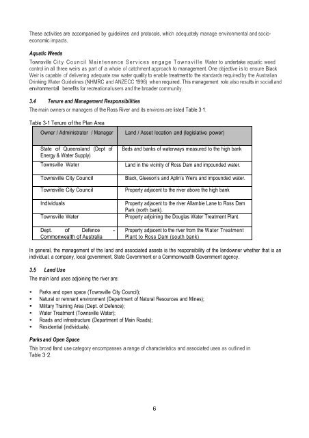
These activities are accompanied by guidelines and protocols, which adequately manage environmental and socioeconomicimpacts.Aquatic Weeds<strong>Townsville</strong> <strong>City</strong> Council Maintenance Services engage <strong>Townsville</strong> Water to undertake aquatic weedcontrol in all three weirs as part <strong>of</strong> a whole <strong>of</strong> catchment approach to management. One objective is to ensure BlackWeir is capable <strong>of</strong> delivering adequate raw water quality to enable treatment to the standards required by the AustralianDrinking Water Guidelines (NHMRC and ANZECC 1996) when required. This management role also results in social andenvironmental benefits for recreational users and the broader community.3.4 Tenure and <strong>Management</strong> ResponsibilitiesThe main owners or managers <strong>of</strong> the Ross River and its environs are listed Table 3·1.Table 3-1 Tenure <strong>of</strong> the <strong>Plan</strong> AreaOwner / Administrator / ManagerState <strong>of</strong> Queensland (Dept <strong>of</strong>Energy & Water Supply)<strong>Townsville</strong> Water<strong>Townsville</strong> <strong>City</strong> Council<strong>Townsville</strong> <strong>City</strong> CouncilIndividuals<strong>Townsville</strong> WaterDept. <strong>of</strong> Defence -Commonwealth <strong>of</strong> AustraliaLand / Asset location and (legislative power)Beds and banks <strong>of</strong> waterways measured to the high bankLand in the vicinity <strong>of</strong> Ross Dam and impounded water.Black, Gleeson’s and Aplin’s Weirs and impounded water.Property adjacent to the river above the high bankProperty adjacent to the river Allambie Lane to Ross DamPark (north bank).Property adjoining the Douglas Water Treatment <strong>Plan</strong>t.Property adjacent to the river from the Water Treatment<strong>Plan</strong>t to Ross Dam (south bank)In general, the management <strong>of</strong> the land and associated assets is the responsibility <strong>of</strong> the landowner whether that is anindividual, a company, local government, State Government or a Commonwealth Government agency.3.5 Land <strong>Use</strong>The main land uses adjoining the river are:• Parks and open space (<strong>Townsville</strong> <strong>City</strong> Council);• Natural or remnant environment (Department <strong>of</strong> Natural Resources and Mines);• Military Training Area (Dept. <strong>of</strong> Defence);• Water Treatment (<strong>Townsville</strong> Water);• Roads and infrastructure (Department <strong>of</strong> Main Roads);• Residential (individuals).Parks and Open SpaceThis broad land use category encompasses a range <strong>of</strong> characteristics and associated uses as outlined inTable 3·2.6