

April 2015 Dry Times interactive
April 2015 Dry Times interactive
April 2015 Dry Times interactive

Create successful ePaper yourself
Turn your PDF publications into a flip-book with our unique Google optimized e-Paper software.
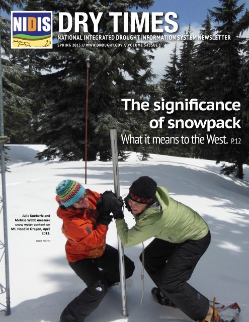
DRY TIMES1NATIONAL INTEGRATED DROUGHT INFORMATION SYSTEM NEWSLETTERSPRING <strong>2015</strong> // WWW.DROUGHT.GOV // VOLUME 5 ISSUE 1The significanceof snowpackWhat it means to the West. P. 12Julie Koeberle andMelissa Webb measuresnow water content onMt. Hood in Oregon, <strong>April</strong>2013.USDA PHOTO
NIDIS: WHO WE ARE3for South Dakota. He has a background in climatology,meteorology and agricultural meteorology. He has been atSDSU since 2003.Art DeGaetanoArt DeGaetano is professor in theDepartment of Earth and AtmosphericSciences at Cornell. He is also the directorof the federally-supported NortheastRegional Climate Center (NRCC). TheNRCC’s mission is to enhance the useand dissemination of climate informationto a wide variety of sectors in the Northeast. Art serves asa climate specialty editor for the Bulletin of the AmericanMeteorological Society.Art has been at Cornell since 1991 serving as thecenter’s research climatologist until 2001. He receivedan interdisciplinary Ph.D. focusing on climatology andhorticulture from Rutgers University.Hailan WangHailan Wang is currently a seniorresearch scientist at Science Systems andApplications, Inc., affiliated with bothNASA Goddard Space Flight Center (GSFC)Global Modeling and Assimilation Office(GMAO) and NASA Langley ResearchCenter. She holds a B.S. in Meteorologyfrom Ocean University of China, and a Ph.D. in AtmosphericSciences from the University of Illinois at Urbana-Champaign. Dr. Wang’s research interests include climatevariability and predictability, droughts, weather and climateextremes, global energy cycle, and GCM modeling of theEarth’s climate. She has been involved in a number of NOAAand NASA research projects investigating North Americandrought drivers and physical mechanisms. Currently, asthe PI of two NOAA projects, she is leading efforts at NASAGMAO of investigating the role of stationary Rossby wavesfor subseasonal development of North American droughts,as well as improving NASA GEOS-5 AGCM simulations ofMadden-Julian Oscillation (MJO) using Dynamics of MJO(DYNAMO) field observations.INTERDISCIPLINARY RESEARCH ANDAPPLICATIONSMark ShaferMark Shafer is Associate StateClimatologist at the OklahomaClimatological Survey, and establishedand leads the Southern Climate ImpactsPlanning Program (SCIPP), a NOAARegional Integrated Sciences andAssessments (RISA) program based atthe University of Oklahoma and Louisiana State University.SCIPP focuses on place-based applications of climate andweather information to improve community preparednessfor a range of natural hazards, including drought. Hisresearch interests focus upon communication between thescientific community and policy makers, particularly inmanaging societal response to extreme events and climatechange. Mark holds an M.S. in meteorology and a Ph.D. inpolitical science from the University of Oklahoma and was acoordinating lead author on the Great Plains chapter in the2014 National Climate Assessment.Matt RollinsMatt Rollins is the national programleader for U.S. Forest Service Wildland Fireand Fuels Research and Development inWashington D.C. In 2000 he got his start asa research ecologist with the Forest Serviceat the Missoula Fire Sciences Laboratory,working on evaluating how changes inwildland fire management strategies affected landscapecomposition, structure, and function over the 20th century;forecasting fire regimes and landscape change under achanging climate using ecological simulation models; andintegrating landscape modeling and satellite imagery fornational fire regime and fuel mapping applications. From2009 to 2014 he worked with the USGS at the EROS datacenter as fire science team leader and at USGS headquartersas their National Wildland Fire Science Coordinator.He earned a B.S. in Wildlife Biology in 1993 and an M.S. inForestry in 1995 from the University of Montana in Missoula,Mont. His Ph.D. is from the University of Arizona in 2000,where he worked at the Laboratory of Tree-Ring Research.ENGAGING PREPAREDNESS COMMUNITIESDeborah BathkeDr. Deborah Bathke is a climatologistwith drought management experience,working with the National DroughtMitigation Center and the University ofNebraska-Lincoln’s School of NaturalResources and Department of Earth &Atmospheric Sciences.She was the assistant state climatologist in New Mexico,where she chaired the state’s Drought Monitoring WorkingGroup. She represented New Mexico in the ClimateAssessment for the Southwest program (CLIMAS), one ofNOAA’s RISA programs. Among the projects she collaboratedon were adapting the dynamic drought index for basins in theCarolinas to the Southwest; implementing a western versionof the AgClimate tools developed by the Southeast ClimateConsortium; and convening technical workshops on tree-ringreconstructions of streamflow. Bathke supervises ongoingstudent research on urban landscaping and drought.She earned her B.S. and M.S. from the University ofNebraska-Lincoln, and her Ph.D. in atmospheric sciencesfrom the Ohio State University.Beth FreemanBeth A. Freeman is the regionaladministrator for FEMA Region VII. Shealso served FEMA in the past as thedirector for Region VII in 2000. She gainedcontinued on next page
4NIDIS: WHO WE AREa deep understanding of Region VII in her 18 years workingfor U.S. Senator Tom Harkin of Iowa. During this time, sheworked as the senator’s regional director and managedoperations for three eastern Iowa offices, and was also thestatewide disaster recovery coordinator.In addition to the strong relationships Freeman developedwith state and local emergency managers while in Sen.Harkin’s office, she has extensive experience workingwith important national partners in disaster response.Freeman holds an M.B.A from the University of Hawaii and abachelor’s degree from Drake University.Kirsten LackstromKirsten Lackstrom is a researchassociate with the Carolinas IntegratedSciences and Assessments (CISA), basedat the University of South Carolina.Kirsten’s work includes research andapplied projects to advance understandingof climate-related vulnerabilities andimpacts in the Carolinas and to enhance the use of climateinformation in decision making and planning processes.PUBLIC AWARENESS AND EDUCATIONDoug KluckDoug Kluck is the central regionclimate services director for the NationalOceanic and Atmospheric Administration’s(NOAA). He has worked for NOAA since1992 with National Weather Service andNational Centers for EnvironmentalInformation (NCEI). Doug’s region covers14 states from Colorado to Michigan. Doug’s responsibilitiesinclude coordinating and informing on climate serviceactivities among federal, state, tribal, academics andprivate interests in the region. Engagement with theabove mentioned groups and interpretation of climateinformation, monitoring, directing research and educationand outreach are all essential parts of his activities. Duringextreme climate events, such as drought and major flooding,Doug coordinates information response, attribution andassessment among core partners.Jim AngelDr. Jim Angel has been the IllinoisState Climatologist since 1997 and beganwork at the Illinois State Water Surveyin 1984. He has a broad interest in allthings related to weather and climate,including droughts, floods, winter storms,heat waves, tornadoes, and long-termclimate change (past, present, and future). He has worked ona number of research projects looking at drought, extremerainfall events, Great Lakes storms, 19th and 20th centuryclimate change, potential future climate change, as well asthe impacts of weather and climate extremes.Besides research, he works with a wide range of users andstakeholders, including students, teachers, homeowners,engineers, other scientists, farmers, as well as federal, state,and local officials on issues related to climate. He maintains awebsite, a blog, and Twitter feed for addressing a wide varietyof climate topics as they pertain to Illinois.DROUGHT PORTAL // DROUGHT.GOVMike BrewerMike Brewer is the manager of NIDIS’sUS Drought Portal (www.drought.gov).He works for NOAA at the NationalCenters for Environmental Information inAsheville, NC. Prior to NCEI, Mike workedat National Weather Service Headquarters,addressing climate data issues and theprovision of climate services. He routinely authors the US,North American, and Global Drought Monitors and operatesthe Global Drought Information System. Prior to NOAA,Mike directed climate research programs at the University ofRhode Island and The George Washington University. Mikehas a PhD in Climatology from the University of Delaware.Kelly SmithKelly Helm Smith was one of the originalemployees of the National DroughtMitigation Center when it was establishedin 1995, contributing experience injournalism, PR and environmentalcommunication. She helped launch thecenter’s original award-winning websiteback when the web was new, worked with the WesternDrought Coordination Council and climate scientists todevelop drought monitoring updates for policymakers, andhelped make the case for establishing the U.S. DroughtMonitor. She took a leave of absence from the drought centerin 2000 to earn a master’s degree in Community and RegionalPlanning and to work with African refugees on behalf ofvarious faith-based and non-profit organizations in Lincoln,Neb. Smith returned to the drought center in 2006. Inaddition to communication, she focuses on drought impactsand on drought planning.Kathleen BoganKathleen Bogan has beencommunications specialist at NIDISsince 2014, following a 32-year career injournalism. Her newsroom homes haveincluded Nation Media in Nairobi, Kenya;the Rocky Mountain News in Denver,Colorado; the Casper Star-Tribune inCasper, Wyoming; and the High Country News in Lander,Wyoming.Before that she worked as a freelance graphic designer,instructed at the National Outdoor Leadership School andOutward Bound, and taught English in Japan. She earned anM.F.A. in printmaking from the University of Montana andher B.A. is in art history and American studies from WilliamsCollege in Massachusetts.
6 RESEARCHNew multi-year projects receiving funding through MAPP in 2014Name of project Goal Investigators“Advancing Drought Monitoringand Prediction Using a Multi-Index Multivariate Framework”“Advancing PredictiveUnderstanding of North AmericanDrought: The Role of the NorthAtlantic SST”“Advancing Probabilistic DroughtMonitoring with the NorthAmerican Land Data AssimilationSystem (NLDAS) throughMultisensor Ensemble DataAssimilation”“Collaborative Research: TowardsPredicting Persistent DroughtConditions Associated withConsecutive La Niña Years”“Development of ProbabilisticDrought IntensificationForecasts Using the GOES-BASEDEvaporative Stress Index”“High-Resolution IntegratedDrought Monitoring”1) Expand, test and implement a multivariate droughtanalysis framework for combining multiple droughtindicators (precipitation, soil moisture, runoff)probabalistically to improve the understanding ofdrought onset, development and termination.2) Assess the proposed multi-index approach.3) Diagnose physical underpinnings of variations inmultivariate index performance for different droughts.4) Use the proposed multivariate multi-index approachto assess one- to nine-month drought predictions usingseasonal forecast datasets.1) Conducting atmospheric GCM experiments tounderstand the dynamical linkages between seasurface temperatures (SST) and U.S. precipitation andtemperature.2) Examination of how predictability may be improved byknowing the state of the Atlantic Multidecadal Variability(AMV) while the rest of the oceans are varying seasonallyand interannually.1) Adding improvements and capabilities to the NLDASdata production and drought monitoring system.2) Assimilating GRACE terrestrial water storage and SMAPsurface soil moisture products into NLDAS system forbetter diagnosis of drought and improvement of initalland conditions.3) Performing a probabilistic historic drought analysisas well as real-time monitoring to both advance ourunderstanding of drought and provide a measure ofdrought uncertainty.Quantifying how predictable the duration of La Niñadroughts is.Develop a drought early warning system based onsatellite-derived maps of evapotranspiration (ET)and forecast output from the National Multi ModelEnsemble (NMME) that will provide probabalistic droughtintensification forecasts over weekly to monthly timescales.1) Using long-term bias correction methods to convertmulit-sensor precipitation estimates (MPE) into a reliablemeasure of long-term deficits and surpluses, then usingthis bias-corrected MPE to calculate drought indices,such as the standardized precipitation evapotrnspirationindex (SPEI) and vrious Palme Drought indices (PDI.)2) Develop and test the implementation of bias-correctedMPE as input inot the North American Land DataAssimilation System. (NLDAS).Amir AghaKouchak (University ofCalifornia Irvine)Mark Svoboda (University ofNebraska-Lincoln)Andy Wood (National Center forAtmospheric Research)Mingfang Ting (Lamont-DohertyEarth Observatory, ColumbiaUniversity)Yochanan Kushnir (Lamont-DohertyEarth Observatory, ColumbiaUniversity)Dong Eun Lee (Lamont-Doherty EarthObservatory, Columbia University)Anthony Barnston (InternationalResearch Institute for Climate andSociety, Columbia University)Richard Seager (Lamont-DohertyEarth Observatory, ColumbiaUniversity)Christa Peters-Lidard (NASA GFSC)David Mocko (SAIC at NASA/GSFC)Sujay Kumar (SAIC at NASA/GSFC)Shugong Wang (SAIC at NASA/GSFC)Michael Ek (NOAA/NCEP/EMC)Youlong Xia (IMSG at NOAA/NCEP/EMC)Jiarui Dong (IMSG at NOAA/NCEP/EMC)Pedro DiNezio (University of Hawaii)Yuko Okumura (University of Texas)Clara Deser (National Center forAtmospheric Research)J.A. Otkin (University of WisconsinMadison)M.C. AndersonM.D. Svoboda (University ofNebraska-Lincoln)C. Hain (University of Maryland)X. ZahnJohn Nielsen-Gammon (Texas A&MUniversity)Ryan RoylesMichael Ek (NOAA EMC)Rebecca CumbieYoulong Xia
8RESEARCHThe observation: The strength of a second-year La Niña correlateswith the depth of oceanic thermocline before onsetPredicting the return of La Niñato improve drought forecastingBY PEDRODINEZIOUniversity of HawaiiYUKOOKUMURAUniversity of TexasCLARADESERNational Center forAtmospheric ResearchAlthough they are often portrayed as a pair ofopposites, El Niño and La Niña are not mirror imagesof each other. El Niño arrives at the beginning ofnorthern winter and rarely lasts through spring as itleads the way to the arrival of La Niña the followingwinter. La Niña, in contrast, often returns for asecond consecutive northern winter, making itsworldwide influence linger. This was the case duringthe winters of 2010-11 and 2011-12, two consecutiveLa Niña years that were both associated withdevastating U.S. droughts.Predicting the onset of La Niña years is notdifficult since they always occur after an El Niño. Thisis why the predictability of La Niña has not receivedmuch research attention. However, predicting thedemise of La Niña has proven to be challenging.For instance, during the summer of 2011 climateprediction centers throughout the world speculatedthat La Niña would return the following winter.Their prediction systems, however, did not provideconsistent results, leading to uncertain forecasts.Our project aims to advance the capability toforecast the return of La Niña and the duration ofassociated drought in the U.S. We think that thekey to making progress is having a computer modelthat can realistically simulate La Niña. Thereforewe rely on the Community Climate System ModelVersion 4 (CCSM4), a computer model developed atthe National Center for Atmospheric Research, whichis capable of simulating the return of La Niña withgreat fidelity (see figure at lower left).We are using this model to look for mechanismsthat could help us do better forecasts. We arecurrently exploring one involving the thermocline,the boundary between frigid waters in the deep oceanand warmer waters on the surface. Longstandingtheories predict that La Niña develops when thethermocline rises closer to the ocean’s surface,allowing cold waters to be mixed upwards, andends when the thermocline returns to deeperdepths, allowing the surface to warm up. Our modeland observations show that in many cases, thismechanism does not succeed in ending La Niña, andcold temperatures persist for an additional winter,prolonging its far-flung impacts for an additionalyear.We have tracked the depth of the thermocline inthe model and in the observations of La Niña. In bothcases we found that the strength of the second yearLa Niña is correlated with the depth of thermoclinebefore the onset. This could provide a year and halflater window for predicting the return of La Niña.We are currently exploring this idea on an actualforecasting system, hoping to tap this mechanism toimprove the prediction of La Niña and its associateddrought.Evolution of La Niña events observed in nature (left) andsimulated by the CCSM computer model (right). Time is shownalong the vertical axis and longitude along the equatorialPacific is shown along horizontal axis.Blue colors indicate that ocean temperatures are colder thannormal, and show La Niña and its return the following winter.Red colors correspond to the warmer temperatures associatedwith the preceding El Niño.Note the striking similarity between the observed andsimulated patterns.
RESEARCH9NCAR team aims to predict probability of deadly phenomenonThe likelihood of heat wavesBY GRANTBRANSTATOR,HAIYAN TENGAND JOETRIBBIANational Center forAtmospheric ResearchHeat waves and associated dry spells occur atshort time scales, from several days to weeks. Inspite of their short duration, heat waves are themost deadly meteorological phenomenon on Earth.In the U.S., heat waves are responsible for moredeaths than floods, hurricanes, and tornadoescombined. The 1995 Chicago heat wave alone led toapproximately 600 deaths over a period of five days.Our team is investigating a new physicalmechanism that may influence the likelihood ofthese events and lead to more accurate probabilityforecasts of heat wave/dry spells at the two- tothree-week range than was previously thoughtpossible.Prior studies have mainly focused on accountingfor the influence of persistent land- or sea-surfaceconditions, or slowly varying diabatic heatinganomalies associated with tropical convection, forproviding predictability of the atmospheric statebeyond about two weeks. Midlatitude atmosphericdynamical processes were considered to be toochaotic to allow significant prediction skill at theseextended ranges.Based on a 12,000-year integration of a numericalmodel that simulates the atmosphere, we havecontinued on next pageFig.1Impacts ofthe leadingcircumglobalteleconnectionpattern (CGT) onthe probability ofheat waves basedon a 12,000-yearsimulation withNCAR’s CommunityAtmospheric Model,version 3.Shading representsthe ratio of theprobability ofa heat waveoccurring 0 days(top), 5 days(second row),10 days (thirdrow) and 15 days(bottom) after anextreme CGT eventrelative to theprobability of aheat wave withoutany precondition.Contours representa composite of 300hPa streamfunctionanomalies duringthose extremeCGT events on thecorresponding daysat ±1, 2,3 x10 6 m 2 s -1intervals.
10 RESEARCHcontinued from previous pageidentified a circulation patternthat appears predictable at theselonger ranges. Analysis of heatwaves in this model indicates thattheir likelihood of occurrence overNorth America is influenced bythis circulation pattern, so thatthere is some skill at predictingthe probability of heat waves anddry spells more than two weeks inadvance.This special circulation pattern,which is also seen in nature, canarise as a result of midlatitudeatmospheric processes. It does notrely on slowly varying surface ortropical conditions, and thus isdistinct from the phenomena thathave previous been relied on fortwo- to three-week predictions.A noteworthy attribute of thepattern (sometimes referred toas a circumglobal teleconnectionpattern, or CGT), is that it consistsof a chain of five pairs of alternatinghigh and low pressure features thatencircle the Northern Hemisphere.Our team has expanded previousstudies of the link between thispattern and U.S. heat waves sothat we now recognize that thispattern and a second CGT impactthe likelihood of heat waves and dryspells in the Northern Hemisphere.When strong circulation anomaliesresemble one of these patterns, theprobability of heat waves can beincreased or reduced in key regionsby a factor of 4, concurrently and inthe following two weeks (Fig.1 onpage 9.)An extension of our effortconcerns investigating how thestructure and behavior of thesecirculation patterns may changeas the climate changes. Usingmechanistic models, we have foundthat the structure of these patternschanges if the mean circulationchanges, in particular the strengthand placement of the troposphericjet.Because of the impact that thesepatterns have on heat waves anddry spells, our work will providea mechanism by which climatechange can influence the likelihoodand geographical distribution ofthese extreme events.Fig. 1Warm seasonclimatology ofprecipitation(shaded) and the850-hPa meridionalwinds (contoured).Winds > 1 m s −1 arecontoured at 1 ms −1 intervals andprecipitation > 2mm day −1 is shaded.The positive(negative) contoursdenote southerly(northerly)meridional windcomponents.Understanding changes in theregional variability of U.S. droughtBY SCOTT WEAVERNOAA/NCEP/CPCSome recent studies suggest that duringmeteorological summer (June, July, August)the interannual variability of North Americanprecipitation has been increasing over the lastsix decades. However, upon closer examination itis evident that trends in this variability are morenuanced than previously thought. During <strong>April</strong>,May and June both the Great Plains and Southeastshowed an increasing trend in interannual variabilityof precipitation over 1950-2010; however, duringJuly, August and September the changes invariability exhibit a more decadal appearance.The North American low-level jet (NALLJ) isa dynamical feature of the atmosphere (Fig. 1,above) that is typically active over the Great Plains,effectively acting as a scale transfer mechanismbetween the large-scale forcing and regional climate.Variations of this pattern focus regional scaleprecipitation anomalies leading to the occurrence ofdrought and/or pluvial conditions (Fig. 2, at left).This research project investigates the role of theNALLJ in promoting the multidecadal changes tothe year-to-year (interannual) variability in regionalprecipitation and the interplay between naturalvariability and anthropogenic climate changeusing a suite of observations and climate modelexperiments.Fig. 2Recurrent patterns of springtime NALLJ variability (contours)and precipitation regressions (shaded) for 1980-2010. TheEOF modes are contoured at 0.2 m s -1 and precipitationregressions are shaded at 0.1 mm day −1 intervals.
RESEARCH11Combining short-range and long-range temperature and precipitation forecastscan help to boost skill of drought forecastToward more skillful predictionBY LIFENGLUOMichigan StateUniversityPANG-NINGTANMichigan StateUniversityDAN BARRIENOAA ClimateProgram OfficeFig. 1Predicted droughtconditions (withuncertainty)(middle andbottom) for June2012 and thecorrespondingverification (top).Lower valuesindicate relativelydrier soil moistureconditions.Forecasts wereissued on <strong>April</strong> 6,2012, and the leadtime is about 2.5months. The ESPforecast approach(bottom) isadopted by theRiver ForecastCenters at NWS,serving as areference here.Fig.2Ensembleprediction ofbasin-averagedroughtconditions overthe ColoradoRiver Basinfor a 4-monthperiod since thetime of forecaston August 23,2013. The blackcurve is theanalysis servingas the proxy forobservations.The gray curvesare from the ESPforecast servingas a reference.Prior research has demonstrated the feasibilityof using hydrological models to predict futuredrought in the U.S. via soil moisture and otherhydrological variables at subseasonal to seasonaltime scales. The key to a skillful prediction ofsuch is the accuracy of the initial hydrologicalstates at the time of the forecast, and the weatherevolution weeks and months afterwards.Since accurate weather prediction is impossiblebeyond about two weeks due to the chaotic natureof the climate system, how to best represent thepossible weather sequences and the associateduncertainties in an ensemble framework is amajor challenge.An ongoing research project, supported bythe NOAA Climate Program Office Modeling,Analysis, Prediction, and Projections (MAPP)program, tackles such a challenge by exploringmethods to better utilize existing weather andclimate forecasts to improve seasonal droughtforecast.In particular, we explore ways to combineshort-range (e.g. seven-day quantitativeprecipitation forecasts, or QPF) and long-range(e.g., Climate Forecast System version 2 orCFSv2) forecasts of temperature and precipitationto better represent the likelihood of weatherconditions at various lead times. The newapproaches developed in this research are eitherbased on Bayesian statistics or machine learningalgorithms that are traditionally used in the fieldof data mining.These methods have been implemented ina Drought Monitoring and Prediction System,and they have shown encouraging results inimproving drought forecast skills. For example,the ability to predict the much drier than normalconditions over the Central Plains for June 2012two months in advance (Fig. 1, above left) makesthese forecasts useful for early drought warning.The system has also shown the ability topredict wetter than normal conditions quitesuccessfully. In August 2013, we predicted higherthan normal rainfall, thus wetter than normalsoil moisture conditions over the Colorado RiverBasin, which was verified nicely by subsequentobservations (Fig. 2, lower left).More information about the project, includingpast and real-time forecast can be found at http://drought.geo.msu.edu/research/forecast/ .
12DATA AND TOOLSA conversation about snowpack and its significance to drought in the West‘Our biggest and mostimportant reservoir’Each week the author of the U.S. Drought Monitor map siftsthrough input from as many as 350 observers and contributors aroundthe nation. The exchange of information from sources reporting onprecipitation, soil moisture, stream flows and other factors, lays thefoundation for the depiction of drought that week.Snowpack is an element that goes into assessing and predictingdrought, especially in the West. But what happens when it rains a lotinstead of snowing? Can there be a “snow drought?”A Drought Monitor author posed this question to the group inFebruary, when much of what had typically fallen as snow in the winterwas now taking liquid form.Read on to follow the conversation and learn more abuot the role ofsnowpack and the nature of drought.BY THE USDMCOMMUNITYMultiple AgenciesWe had an interesting discussion during ourU.S. weather briefing today at USDA, and it raiseda question that I know there’s no easy answer for,but whatever guidance we could get would be a bighelp.In many areas of the West, in particularthe Northwest, we see near- to above-normalrainfall but at the same time much below-normalsnowpack. If you have a mild, wet winter (evenwetter than normal), and you enter the spring withfull reservoirs but meager snowpack, what role willthe meager snowpack play moving forward?More simply put, what percentage of total wateruse does the snowpack supply? I expect the answeris complex…EricEric D. Luebehusen, Meteorologist, USDAOffice of the Chief Economist, World Agricultural Outlook BoardWashington, D.C.Good question. The main challenge lies in thetype and use of the reservoirs we have in the West.For reservoirs with no flood control capacity, itdoesn’t matter as much as for those which rely onsnowmelt to fill the flood reserve space that is heldthrough the winter.The exception to that rule is for reservoirs thatmodulate the flow distribution of the snowmeltto accommodate water use through the summer.These reservoirs are usually small compared tothe runoff volume of the watershed behind them.Mother Nature doesn’t always provide a nicesmooth distribution of snowmelt runoff throughthe spring and summer. In those cases the reservoiris managed more heavily to try to balance runoffand deliveries without “losing” too much runoff toflows over the spillway.Each watershed is unique in its structure,and water management needs and input fromthe community are vital. For reservoirs thathave a flood reserve space, the snowpack is likea secondary reservoir that is used to fill in thatspace through the spring and then can be used fordeliveries through the summer and fall for a varietyof purposes.When the snowpack isn’t there, there is a lot lesswater to work with to balance a bunch of competingneeds. If there are a lot of winter flows, any waterthat goes into the flood reserve space in thereservoir must be released as soon as it is safe to doso, and is often “lost” for other purposes.There’s a lot of research on how to use forecaststo enable more dynamic consideration of how muchflood reserve space to have on hand in reservoiroperations.MikeMichael Anderson, State ClimatologistCalifornia Department of Water ResourcesSacramento, Calif.I echo what Mike said regarding reservoirs.There are many papers on the importance ofthe snowpack to the Pacific Northwest (PNW);the Northwest chapter of the National ClimateAssessment covers this in detail. Not all of oursurface water supply is fed by a man-madereservoir. We rely on the snow to act as our biggestand most important reservoir.Beyond hydrology, there are the factors of soilmoisture and bare ground, which can exacerbatewildfires in the summer (though in-seasonconditions matter a lot as well), and impact a multimilliondollar winter recreation industry.We haven’t had much of a winter here and it isvery apparent. Bend’s annual WinterFest is thisweekend (Feb. 14, <strong>2015</strong>); it will be in the high 50scontinued on next page
13continued from previous pageand there’s not a lot of snow to be found. In goodnews, we’ve also heard stories of successful waterconservation by irrigation districts in these recentsnowpack-limited years.Snow trumps rain here in the mountains in thePNW.KathieKathie Dello, Associate Director, Oregon Climate ChangeResearch InstituteDeputy Director, Oregon Climate ServiceCollege of Earth, Ocean, and Atmospheric SciencesOregon State UniversityCorvallis, OregonAnother impact, at least for Washington State,is that there are minimum streamflow requirementson several waterways. Junior water rights holdersmay be cut off in late summer if streamflows dropbelow the minimum, which is more likely in lowsnowpackyears, especially in watersheds withoutreservoirs.How about a new Drought Monitor category forplenty of rain and not enough snow?!KatherineKatherine Rowden, Service HydrologistNational Weather Service / NOAA, Washington StateOne add-on for the fisheries flows Katherinementioned is that storage is needed in thereservoirs to maintain a cold pool of water toprovide the right temperature of water for the fishin the late summer and fall. It might look like wateris available, but it may be being held for a specificpurpose that is not the traditional water supply.MikeI dug up a few articles mentioning snowpack,precipitation amounts and water supply, butnone of these give any rule of thumb to go by, justsome food for thought. Snowpack as percentage oftotal water supply varies considerably from placeto place, with some reservoirs needing sufficientannual precipitation while others can hold enoughwater to last multiple years.The low snowpack/above-normal precipitationissue has been bothering me. Can we considerareas to be in “drought” when average or moreprecipitation falls, even in the wrong form? Evenif the water supply runs low later in the year? If anarea getting normal precip or better, even falling atthe wrong time of year, is it drought that causes thewater shortages -- or isn’t it?DeniseDenise Gutzmer, Drought Impact SpecialistNational Drought Mitigation Center,University of Nebraska-LincolnLincoln, Neb.When I talk with Montana school groups, Iexplain the snowpack as our bank account of waterthat we need to get through the summer. If we don’tcontinued on next pageAn NRCS workermeasures thesnowpack at theGRBC MeadowsSnow Course,Utah in May 2005.Photo by KendallDatrup, one of thewinners in the2012 NRCS photocontest.HTTP://WWW.WCC.NRCS.USDA.GOV/PHOTO_CONTEST/2012/INDEX.HTML
14DATA AND TOOLSmajor impacts on recreation, increase fire risk, andlead to moisture stress on high elevation trees.It makes our USDM depiction a lot morechallenging, especially if the area has seen abovenormalprecipitation. I like to occasionally raise theissue of having a “Water Monitor” sister product,which would be focused a lot more on the “supply”side.Then again, it would take quite some time to rundown all the “rule curves” and managing entitiesfor every storage body (thousands) in the U.S., andthen knowing why or how they are managing thewater during any given year, in order to tease outwhat is standard operating procedure vs. climate ordrought-induced impacts.The higher temperature trends are certainly amajor contributing issue.MarkMark Svoboda, Climatologist, Monitoring Program Area LeaderNational Drought Mitigation Center,University of Nebraska-Lincoln, Lincoln, NebraskaDan Kenney takesnotes at theSkwentna snowcourse in Alaskain February 2009.Photo by RickMcClure, one ofthe winners in the2012 NRCS photocontest.HTTP://WWW.WCC.NRCS.USDA.GOV/PHOTO_CONTEST/2012/INDEX.HTMLcontinued from previous pageget enough snow, or we lose snowpack too early,we’re going to see reduced stream flows earlier inthe summer.Climatologically, we receive less precipitationand fewer precipitation events in July and Augustcompared to May and June. Spring and earlysummer bring more stratiform events which spreadout a given amount of precipitation over time andspace, compared to mid- and late summer whichare more convective, with storms dropping thatgiven amount of precipitation in limited time andspace. The convective storms provide only a veryshort-term benefit to stream flows. The melt of theremaining higher mountain snowpack helps keepstreams running through at least part of this period.Problems from the lower stream flows includenot only irrigation. Junior water rights holderscould be cut off. And the recreation industry suffers.Fishing is huge here, a big part of tourism. Reducedstream flows mean increased water temperatureand can lead to decreased water quality, both ofwhich can stress fish, and lead to stream closures.Some are just ‘hoot owl’ closures, something like 2p.m. to midnight; others are 24-hour closures.While we do have reservoirs, we don’t have themon every stream or river. And because reservoirshave to be managed for a variety of purposes, theycan’t always keep the downstream flows running at‘ideal’ levels.GinaGina Loss, Senior Service HydrologistGreat Falls Weather Forecast Office, Great Falls, MontanaYes, you can have a “snow drought”.Mike Palecki and others have done research onthese types of droughts, as they can and do haveThis is the webcam from Hoodoo skiresort (above). I’d certainly call this a drought.Temperature can’t be overlooked. You can’t ski onrain.KathieI’ve read about plenty of snow droughts,which have far-reaching consequences, and don’targue with that concept, but can we honestly termit a drought when there is above normal precipin the wrong form or at the wrong time to bolsterthe snowpack? It may lead to water shortageslater, but it isn’t a drought exactly. It’s more of atiming and temperature issue. If warm temps meltthe snowpack early, we don’t call it drought. It’s atemperature issue preventing or melting the snow.Denisecontinued on next page
15continued from previous pageIt is very different type of creature than is typicallydepicted in the Drought Monitor. Consider though, that forWashington, the statutory definition of drought conditions:“water supply conditions where a geographical area or asignificant part of a geographical area is receiving, or isprojected to receive, less than seventy-five percent of normalwater supply as the result of natural conditions, and thedeficiency causes, or is expected to cause, undue hardship towater users within that area.”Currently, there are many basins in Washington that willmeet these criteria for the summer water supply forecastseason unless snowpack suddenly improves or we get somereally impressive spring rains. I know there are other criteriafor state drought declaration, but the water supply forecastsare definitely a part of it.KatherineI agree with you when: 1) Precipitation is above normalat most time scales; 2) reservoirs and streams are at or abovenormal; 3) soil moisture is wet; 4) snow is less because ofunseasonable warmth causing precipitation to fall as rain (ormelt existing snow) while the snow season is still ongoing.To me, it becomes more of a drought later in the spring,once snow season is over and normal spring snowmeltshould be occurring, but isn’t. By adding the category“abnormally dry” (D0) to the Drought Monitor now, it’s likeforecasting drought and/or reduced snowmelt runoff in thespring and summer. The Drought Monitor isn’t supposedto be forecasting. I’d be more inclined to add D0 or droughta bit later in the season when impacts (such as reducedstreamflows) are occurring, maybe <strong>April</strong> or May.Dave MiskusDavid Miskus, Meteorologist/Drought POCClimate Prediction Center OPBCollege Park, Md.I think this discussion just reinforces what we alreadyknew about drought: it is a complex, multidimensionalsystem about which we are still learning.Russell MartinKeep in mind that several other “snow drought” cases(think east of the Rockies in the northern tier states) are dueto actual precipitation deficits independent of temperature.The deficits can impact recreation and economies, exposetrees, yards, land cover and wildlife to bitter cold temps, andcan lead to more grass fires when dry grasses aren’t buried inwet snow, in addition to the missing moisture not working itsway into the soil profile in the spring when soils thaw.So, not all “snow droughts” are created equally, and itcertainly isn’t just a western phenomenon.MarkAt this time of year (February), the many reservoirsare kept fairly empty, or with at least enough space to makesure they can capture the majority of the peak snowmeltrunoff when it occurs. Larger federal and state reservoirs aremandated to keep to a rule curve for refilling. This usuallydoes not allow them to capture much rainfall in the winter,unless they are below where they should be, so most of thisrain has probably passed through many of the reservoirs.Since the precipitation pattern in much of the West is highlywinter dominant, the stored water in the snowpack andsnowmelt make up a huge percentage of the annual waterbudget. That is why we are able to fairly accurately providestreamflow forecasts based on the snowpack. After <strong>April</strong> andMay, only a very small percentage of the annual precipitationbudget for most areas remains to fill out the water year (Oct.1-Sept. 30).Snowmelt provides the primary source of water forirrigation, municipal needs, power, fish and wildlife health,in-stream flow, etc. Winter rainfall across the region may benear average, serve to bolster the current soil moisture, andprovide short term streamflow and reservoir water for thosereservoirs that were down to minimum levels. But mostof this water will be long gone before we get to the springgrowing season, and for many other uses.We still need to have water from snowmelt to fill streamsfor the <strong>April</strong> to July water supply for spring and summer use,when there is next to nothing falling from the sky. So in myview, “no snow” is a pretty serious drought for water use andmanagement in many areas of the West.It is also very true that the current and future impacts areeasily mixed in this snow discussion, so it is very difficult foranyone to take everything into consideration and to decidewhat is providing an impact when! There is always futurerain that is unknown.JolyneJolyne Lea, HydrologistUSDA NRCS National Water and Climate CenterPortland, Ore.I think we have tended to lump this all under“drought” as insufficient water to meet needs, and broughtabout largely by natural processes.That’s still my own inclination.KellyKelly Redmond, Research Professor ClimatologyDesert Research Institute,Reno, NevadaSnow droughts do exist!Being married to a ski coach for nearly 25 years and a raceparent for more than 18 years, watching ski areas move orchanges in ski races were my first signs of snow drought. Thisyear numerous ski races in the intermountain division havebeen moved or canceled because of lack of snow or rain.Impacts on the economy are felt through travel, lodging,lift tickets, and food for racers and parents.We will be seeing all 3 conditions (drought, normal yearand wet year) this summer. Your (our) question and challengeis how to drawn this on a single map…It is the snowpack that sustains the stream flows. Rainrunoff events are flashy in nature and do not provide thevolume of water that snowmelt does. Last year the OwyheeBasin irrigation water ran out of July 18.RonRon Abramovich USDA NRCS Snow SurveyWater Supply Specialist, Boise , Ida.
16 IMPACTSMAY 2009No droughtAUGUST 2010D1: Moderate droughtMAY 2011D3: Extreme droughtCorrelating the U.S. Drought Monitor with scenes on the ground over the yearsThe rise and fall (again) of thepond on the McVicker farmThis satelliteimage fromGoogle mapswas likely takensummer of 2014,when the pondwas full for abrief period, orpossibly before2010, according toMcManus.The approximatelocation ofthe pond: GPScoordinates:36.695489,-99.632000PHOTOS BY GARY MCMANUSWhat does drought look like? Oklahoma StateClimatologist Gary McManus has been tracking the stateof a spring-fed pond south of Buffalo, Okla., where hefished as a kid. His photos show its journey from 2009through early <strong>2015</strong>.The pond was looking flush in May 2009, about a monthafter a good 20-26 inch snowfall event in late March. Asthe drought advanced, the pond dried up for the first andonly time since it was built more than 40 years ago.When ten inches of rain fell last June, the McVickerfarm appeared to have recovered. Then another eightmonths of drought commenced and the waters evaporatedagain, shrinking the shoreline back to where it had beenin January 2014. With the warm, windy days typical ofspringtime around Buffalo ahead, its future appears grim.WHAT DOES DROUGHT LOOK LIKEWHERE YOU LIVE?Drought in Maine looks different from drought in Arizona.NIDIS and the National Drought Mitigation Center (NDMC)would like to see what you see when you see droughtin your part of the world. Help us out by being a citizenscientist! You can upload pictures to the Drought ImpactReporter ore-mail to nidis.program@noaa.gov. We’d like tofeature the best shots in upcoming editions of <strong>Dry</strong> <strong>Times</strong>.
17JAN 2012D3: Extreme droughtMARCH 2012D2 Severe droughtAUGUST 2012D4: Exceptional droughtOCTOBER 2012D4: Exceptional droughtMARCH 2013D3: Extreme droughtJANUARY 2014D2 Severe droughtJUNE 2014D3: Extreme droughtFEBRUARY <strong>2015</strong>D3: Extreme droughtMaps are from the U.S Drought Monitorarchive http://droughtmonitor.unl.edu/Home/StateDroughtMonitor.aspx?OKD0: Abnormally dryD1: Moderate droughtD2 Severe droughtD3: Extreme droughtD4: Exceptional drought
EARLY WARNING SYSTEMS: CALIFORNIA192014 was driest of years since 2011, with exceptional (D4) droughtcovering more than half the state by DecemberCalifornia drought: Couldit have been foreseen?ASSESSMENT REPORTCauses and predictabilityof the 2011-14California DroughtRICHARD SEAGERLamont Doherty Earth Observatory of Columbia UniversityMARTIN HOERLINGNOAA Earth System Research LaboratorySIEGFRIED SCHUBERTHAILAN WANGNASA Goddard Space Flight CenterBRADFIELD LYON,International Research Institute for Climate and SocietyARUN KUMARNOAA Climate Prediction CenterJENNIFER NAKAMURANAOMI HENDERSONLamont Doherty Earth Observatory of Columbia UniversityThe report, “Causes and Predictabilityof the 2011-14 California Drought isa project of the Narrative Team of theNOAA Drought Task Force, organizedby the Modeling, Analysis, Predictionsand Projections (MAPP) Program ofthe NOAA/OAR Climate ProgramOffice.Lead Author:R. SEAGERCo-Authors:M. HOERLING,S. SCHUBERT,H. WANG,B. LYON,A. KUMAR,J. NAKAMURA,N. HENDERSONHow severe has the California drought been?Statewide precipitation during the last threewinters (November-<strong>April</strong> 2011/2012 through2013/2014) ranked the second lowest sinceofficial measurements began in 1895. Onlythe consecutive three-year period of 1974/75through 1976/77 was drier. As one criticalindication of the cumulative and growingimpact of this drought, the September 2014assessment of statewide water storage wasonly about 50% of average for that time of year,according to the California Department of WaterResources. Water supply depletion has notresulted from the lack of precipitation alone,but also from very high temperatures with the2013/14 winter being the state’s warmest onrecord when this report was written. 2014/15has been even warmer.As the 2014/<strong>2015</strong> wet season commenced,the U.S. Drought Monitor indicated almostall of California to be experiencing extremeto exceptional drought. The situation haddeteriorated greatly during 2014, the thirdconsecutive year of low precipitation and thedriest of 2011-14. Exceptional conditions (D4)covered more than half of the state in December,whereas one year earlier no regions in the statewere considered to be under D4.What factors caused the California drought?Weather conditions were key. A high pressureridge off the West Coast diverted the trackof storms during all three winters, typical ofhistorical droughts. West Coast high pressurewas rendered more likely during 2011-14 byeffects of sea surface temperature patterns.The drought’s first year (2011/12) was likelythe most predictable, when La Niña effectslargely explained high pressure off the WestCoast, though simulations indicate that highpressure continued to be favored due to oceaneffects in 2012-14.Is the California drought a symptom of longtermclimate change?The current drought is not part of a longtermchange in California precipitation, whichexhibits no appreciable trend since 1895. Keyoceanic features that caused precipitationinhibiting atmospheric ridging off the WestCoast during 2011-14 were symptomatic ofnatural internal atmosphere-ocean variability.Model simulations indicate that humaninducedclimate change increases Californiaprecipitation in mid-winter, with a low-pressurecirculation anomaly over the North Pacific,opposite to conditions of the last three winters.The same model simulations indicate a decreasein spring precipitation over California.However, precipitation deficits observedduring the past three years are an order ofmagnitude greater than the model-simulatedchanges related to human-induced forcing.Nonetheless, record-setting high temperaturesthat accompanied this drought were likely mademore extreme due to human-induced globalwarming.
20EARLY WARNING SYSTEMS: MISSOURI RIVER BASINWatershed management groups and stakeholders in southwestern Montana sharesuccesses, plans for the future in a drought planning workshopWorking towardresilience,step by stepBY CHAD MCNUTT AND KATHLEEN BOGAN / NIDISOn March 16-17, NIDIS, the National DroughtMitigation Center (NDMC) and Montana’sDepartment of Natural Resources and Conservation(DNRC) hosted a workshop in Bozeman, Montana tobring together participants from the Upper MissouriBasin to discuss ways to improve drought earlywarning and drought resilience. The event,“BuildingDrought Early Warning Capacity,” was part of a largerdemonstration project for Montana announced bythe National Drought Resilience Partnership (NDRP).The workshop gathered watershed-based teamsthat could initiate a conversation with theircommunities on managing scarce water resourcesand preparing for future drought conditions.Representatives of seven sub-watershedsattended (shown on the map above), including theBeaverhead, Ruby, Big Hole, Upper Gallatin, LowerGallatin, Madison, and Jefferson Rivers. The diversecontinued on next page
22 EARLY WARNING SYSTEMS: MISSOURI RIVER BASINWorking toward resilience, step by stepcontinued from previous pageto recognize the work already underway; 2) Howto leverage and build on the successes many ofthe watersheds have developed , such as the LowerGallatin’s Watershed Restoration Plan; 3) How toutilize the active NGO partners, state agencies,universities, and private citizen interest.BSWC members identified some initiatives totake away from the workshop, in order to contuedeveloping their drought plans:Comments on the workshopThe Beaverhead Watershed Committee’s Facebook page described thegroup’s takeaways and future plans from the workshop as including“many new tools and ideas for addressing drought risk in BeaverheadCounty.“Going forward we hope to work with the Beaverhead County DroughtTask Force, the Clark Canyon Joint Board, and other community groupsto enhance their access to hydrologic data such as precipitation,snowpack, stream flows, soil moisture, and more. We also intend to helpBeaverhead County stakeholders understand where the data comesfrom and how it is used for decision making at the state and federallevel.“One creative and fun idea that we are also exploring is producing avideo documentary in which we interview longtime Beaverhead Countyresidents about their experiences with previous notable drought years.”n Develop a Missouri Basin Headwaters Plan:Working through the BSWC members, develop a planthat integrates the watersheds to allow early warningand proactive planning for drought.n Assess way to integrate existing water planningconcepts into the discussion of drought early warningand overall drought resilience. For example:-- Use the process of Watershed RestorationPlanning and 319 funding to get stakeholders(e.g. irrigators) in the watershed more involved indrought-related planning.-- Assess models and or mechanisms that couldsupport sub-watershed planning efforts like theWest Gallatin plann Conduct drought scenario workshops, toexchange perspectives and assess triggers, data gapsand coordination needs within as well as amongwatersheds.n Continue the dialogue with the NDMC, NIDIS,and DNRC through webinars and in-person meetingsto exchange information on drought planning (suchas NDMC’s Managing Drought Risk on the Ranch),improve understanding of seasonal climate forecasts,and other topics of interest.n Apply water conservation efforts like those usedby the City of Bozeman for watersheds with largeresorts and developments.WEBINARS: Keep up with current conditions in your areaSeveral of NIDIS’ partner organizations offer regular live reports on drought conditions in their regions, throughwebinars. Upcoming and past webinar listings are at http://www.drought.gov/drought/content/regional-programs/regional-drought-webinars. How to sign up for future events, or view past sessions:Managing Drought in the SouthernPlainsThe Southern Climate ImpactsPlanning Program (SCIPP) holds bi-weeklydiscussions of drought and its impacts onthe second and fourth Thursdays of eachmonth at 11:00 a.m. Central Time. Statescovered include Oklahoma, Texas, andNew Mexico. To join in, please register athttp://www.southernclimate.org/ . Youcan view past webinars on YouTube athttps://www.youtube.com/user/SCIPP01 .Upper Colorado River Basin WebinarThe Colorado Climate Center conductsClimate, Water and Drought Assessmentbriefings detailing events in the basinstates of Colorado, Utah and Wyoming.To register, please visit: http://ccc.atmos.colostate.edu/drought_webinar_registration.phpMidwest and Great Plains DroughtUpdateThe National Oceanic and AtmosphericAdministration (NOAA), the AmericanAssociation for State Climatologists(AASC) and the High Plains RegionalClimate Center (HPRCC) have respondedto drought across the Midwest andGreat Plains by organizing, creatingand presenting webinars since July2012. These presentations are heldmonthly but can be more frequent whenconditions warrant.The webinars consist of a regionalclimate summary, impacts due to droughtand climate outlooks.The webinars are held on the thirdThursday of every month at 1pm CentralTime. A link to the webinar registrationpage, along with recordings andpowerpoints from previous webinars, canbe found here: http://www.drought.gov/drought/news/midwest-and-great-plainsdrought-webinar-jan-15-<strong>2015</strong>.Apalachicola-Chattahoochee-Flint (ACF) River Basin DroughtAssessment WebinarThe Southeast Climate Consortium(SECC) organizes a drought assessmentwebinar that includes current conditionsand outlooks for the ACF basin.Currently the webinars occur monthly,and will increase in frequency if droughtconditions warrant. Webinar partnersinclude the U.S. Army Corps of Engineers,National Weather Service and USGS. Toreceive webinar announcements, senda request to reuteem@auburn.edu toget on the email list. To view previouswebinar summaries, visit http://www.drought.gov/drought/regional-programs/acfrb/acfrb-home and choose from thelist on the right side of the page.