Chapter 4: Affected Environment - Aitkin County Government
Chapter 4: Affected Environment - Aitkin County Government
Chapter 4: Affected Environment - Aitkin County Government
- No tags were found...

Create successful ePaper yourself
Turn your PDF publications into a flip-book with our unique Google optimized e-Paper software.
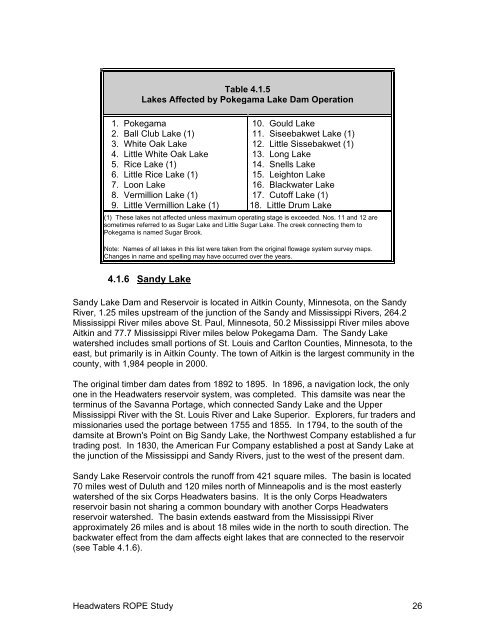
Table 4.1.5Lakes <strong>Affected</strong> by Pokegama Lake Dam Operation1. Pokegama2. Ball Club Lake (1)3. White Oak Lake4. Little White Oak Lake5. Rice Lake (1)6. Little Rice Lake (1)7. Loon Lake8. Vermillion Lake (1)9. Little Vermillion Lake (1)10. Gould Lake11. Siseebakwet Lake (1)12. Little Sissebakwet (1)13. Long Lake14. Snells Lake15. Leighton Lake16. Blackwater Lake17. Cutoff Lake (1)18. Little Drum Lake(1) These lakes not affected unless maximum operating stage is exceeded. Nos. 11 and 12 aresometimes referred to as Sugar Lake and Little Sugar Lake. The creek connecting them toPokegama is named Sugar Brook.Note: Names of all lakes in this list were taken from the original flowage system survey maps.Changes in name and spelling may have occurred over the years.4.1.6 Sandy LakeSandy Lake Dam and Reservoir is located in <strong>Aitkin</strong> <strong>County</strong>, Minnesota, on the SandyRiver, 1.25 miles upstream of the junction of the Sandy and Mississippi Rivers, 264.2Mississippi River miles above St. Paul, Minnesota, 50.2 Mississippi River miles above<strong>Aitkin</strong> and 77.7 Mississippi River miles below Pokegama Dam. The Sandy Lakewatershed includes small portions of St. Louis and Carlton Counties, Minnesota, to theeast, but primarily is in <strong>Aitkin</strong> <strong>County</strong>. The town of <strong>Aitkin</strong> is the largest community in thecounty, with 1,984 people in 2000.The original timber dam dates from 1892 to 1895. In 1896, a navigation lock, the onlyone in the Headwaters reservoir system, was completed. This damsite was near theterminus of the Savanna Portage, which connected Sandy Lake and the UpperMississippi River with the St. Louis River and Lake Superior. Explorers, fur traders andmissionaries used the portage between 1755 and 1855. In 1794, to the south of thedamsite at Brown's Point on Big Sandy Lake, the Northwest Company established a furtrading post. In 1830, the American Fur Company established a post at Sandy Lake atthe junction of the Mississippi and Sandy Rivers, just to the west of the present dam.Sandy Lake Reservoir controls the runoff from 421 square miles. The basin is located70 miles west of Duluth and 120 miles north of Minneapolis and is the most easterlywatershed of the six Corps Headwaters basins. It is the only Corps Headwatersreservoir basin not sharing a common boundary with another Corps Headwatersreservoir watershed. The basin extends eastward from the Mississippi Riverapproximately 26 miles and is about 18 miles wide in the north to south direction. Thebackwater effect from the dam affects eight lakes that are connected to the reservoir(see Table 4.1.6).Headwaters ROPE Study 26