

Index of all sites - South Worcestershire Development Plan
Index of all sites - South Worcestershire Development Plan
Index of all sites - South Worcestershire Development Plan

Create successful ePaper yourself
Turn your PDF publications into a flip-book with our unique Google optimized e-Paper software.
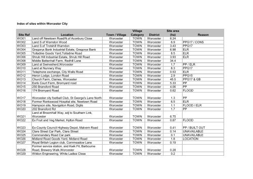
<strong>Index</strong> <strong>of</strong> <strong>sites</strong> within Worcester CitySite Ref Location Town / VillageVillageCategory DistrictSite area(ha)ReasonWO01 Land <strong>of</strong>f Newtown Road/N.<strong>of</strong> Aconbury Close Worcester TOWN Worcester 6.24WO02 Land S <strong>of</strong> Warndon Wood Worcester TOWN Worcester 6.9 PPG17 / CONSWO03 Land S.<strong>of</strong> Trotshill Warndon Worcester TOWN Worcester 3.43 PPG17WO04 Gregorys Bank Industrial Estate, Gregorys Bank Worcester TOWN Worcester 6.98 ELRWO05 Tolladine Goods Yard,Tolladine Road Worcester TOWN Worcester 8.5 ELRWO06 Shrub Hill Industrial Estate, Shrub Hill Road Worcester TOWN Worcester 3.93 ELRWO08 Middle Battenh<strong>all</strong> Farm, Redhill Lane Worcester TOWN Worcester 34.4WO09 Land at Swinesherd,Worcester Worcester TOWN Worcester 1.7 PP / ELRWO10 Land at Nunnery Way Worcester TOWN Worcester 8.3 PPG17WO11 Telephone exchange, City W<strong>all</strong>s Road Worcester TOWN Worcester 0.53 ELRWO12 Heron Lodge, London Road Worcester TOWN Worcester 2.9 PPG15WO13 Church Farm, Claines, Worcester Worcester TOWN Worcester 45.5 PPG17 & GBWO14 Earls Court Farm, Bromyard road Worcester TOWN Worcester 5.33 PPWO15 250 Bransford Road Worcester TOWN Worcester 4.06 PPWO16 174 Bromyard Road Worcester TOWN Worcester 0.62 FLOODWO17 Worcester city footb<strong>all</strong> Club, St George's Lane North Worcester TOWN Worcester 1.3 PPWO18 Former Ronkswood Hospital site, Newtown Road Worcester TOWN Worcester 6.5 ELRWO19 Hampson site, Navigation Road, Diglis Worcester TOWN Worcester 1.1 FLOOD / ELRWO20 202 Bransford Rd Worcester TOWN Worcester 1.7 PPWO21Land at Broomh<strong>all</strong> Way, adj to <strong>South</strong>ern Link,Worcester Worcester TOWN Worcester 6.75WO22 Ex Fruit and Veg Market, Hylton Road Worcester TOWN Worcester 0.87 FLOODWO23 Ex-County Council Highway Depot, Malvern Road Worcester TOWN Worcester 0.41 PP / BUILT OUTWO24 Clare Street Car Park, Clare Street Worcester TOWN Worcester 0.14 UNAVAILABLEWO25 Commandery Road Car park Worcester TOWN Worcester 0.1 UNAVAILABLEWO26 Midland Road Goods Yard, Midland Road Worcester TOWN Worcester 1.8 LOCATIONWO27 Royal British Legion club, Cornmeadow Lane Worcester TOWN Worcester 0.19WO28Former service station, and Kwik Fit, BarbourneRoad, Brewery Walk,Worcester Worcester TOWN Worcester 0.28WO29 Wildon Engineering, White Ladies Close Worcester TOWN Worcester 0.2
WO30 Land adj railway, <strong>of</strong>f Battenh<strong>all</strong> Road Worcester TOWN Worcester 0.69 PPG17WO31Worcester Swimming Pool/Fitness Centre,Sansome Walk Worcester TOWN Worcester 0.9 PPG17WO32 Masonic H<strong>all</strong>, Lansdowne Cresent Worcester TOWN Worcester 0.3WO33 Land at Cedar Avenue Worcester TOWN Worcester 1.3 OWNERSHIPWO34 Warndon Service Station, Cranham drive Worcester TOWN Worcester 0.1WO35 Bus Depot, Pheasant Street Worcester TOWN Worcester 0.89WO36 Corner <strong>of</strong> Lowesmoor Place / Padmore Street Worcester TOWN Worcester 0.2WO37 Industrial area, Pope Iron Road Worcester TOWN Worcester 0.9WO38 Land corner <strong>of</strong> Newtown Road / Ronkswood Hill Worcester TOWN Worcester 0.26 OWNERSHIPWO39 National Car Hire, Bromwich Road Worcester TOWN Worcester 0.22WO40 Adj to Paul Pry pub, The Butts Worcester TOWN Worcester 0.043 BUILT OUTWO41 R/o 2-32 Ribble Close Worcester TOWN Worcester 0.04 PPG17WO42 Old Gas works, Medway Road Worcester TOWN Worcester 1.1WO43 Derwent Close, Industrial Area, Derwent Close Worcester TOWN Worcester 0.5 ELRWO44 Adj Maple Leaf PH, Canada Way Worcester TOWN Worcester 0.4 PPWO45 Land <strong>of</strong>f Albert Road Worcester TOWN Worcester 0.7WO46 St.Richards Hospice, Rose Hill Worcester TOWN Worcester 0.35 PPG17 / PPG15WO47 Orchard Street Industrial Area Worcester TOWN Worcester 1.3 UNVIABLEWO48 Commercial premises, Portland Street Worcester TOWN Worcester 0.2 ELRWO49 Copenhagen Street Car Park, Worcester Worcester TOWN Worcester 0.49 FLOOD / LOCATIOWO50 Rear Bingo Club, <strong>of</strong>f Taylors Lane Worcester TOWN Worcester 0.15 COMMUNITYWO51 Austin House, Castle Street Worcester TOWN Worcester 0.286 COMMUNITYWO52 Fire Brigade HQ, Copehagen St Worcester TOWN Worcester 0.16 RETAILWO53 King St Car Park Worcester TOWN Worcester 0.3 UNAVAILABLEWO54 8-10 Nash's Passage Worcester TOWN Worcester 0.1WO55 Garage, Corner <strong>of</strong> Bath Road, Commandery Road Worcester TOWN Worcester 0.14WO56 Tansell Garage, Diglis Road Worcester TOWN Worcester 0.12WO57 26 and 26a Bath Road Worcester TOWN Worcester 0.8WO58 Goodman Bayliss Works/Halcrow Worcester TOWN Worcester 2.3 ELRWO59 49-63 Battenh<strong>all</strong> Road Worcester TOWN Worcester 1.71 UNVIABLEWO60 6-20 Whittington Road Worcester TOWN Worcester 2.27WO65 Perdiswell and Moathouse Farm Worcester TOWN Worcester 105 PPG17 /FLOOD/GBWO66Land N. <strong>of</strong> Worcester and B'ham canal and S. <strong>of</strong>A449 Worcester TOWN Worcester 37.6 PPG17 /FLOOD/GB
<strong>Index</strong> <strong>of</strong> <strong>sites</strong> within Strategic positions / Edge <strong>of</strong> Worcester or DistrictSite Ref Location Town / VillageVillageCategory DistrictSite area(ha)Reason61B-01 Site at Northwick Road. Bevere STRA Wychavon 2.56 FLOOD61B-02 Land adjacent to NorthwickRoad (and Hill House) Bevere STRA Wychavon 0.6 DUPLICATED61B-03 Land at Hill House and Hill Top Bevere STRA Wychavon 1.6561B-04 Land north <strong>of</strong> Bevere Lane Bevere STRA Wychavon 4.4 LOCATIONWY64 Firs Farm, Bevere Lane/Green Lane, Bevere Bevere STRA Wychavon 20.8788-1 Land at Walkers Lane, Whittington Whittington 3 Wychavon 0.5988-2 Part <strong>of</strong> land between Kilbury Dr and Swinesher Way Whittington 3 Wychavon 7.2888-3 Land between Kilbury Dr and Swinesherd Way Whittington 3 Wychavon 4.6888-4 Land west <strong>of</strong> M5 Whittington Whittington 3 Wychavon 24.29 LOCATION/ SCALE88-5 Land south <strong>of</strong> Swinesherd Way Whittington 3 Wychavon 1.1 ACCESS/LOCATION88-6 Land west <strong>of</strong> Whittington Grange Whittington 3 Wychavon 2.62 DUP/ACCESS/LOC88-7 Land west <strong>of</strong> Whittington Grange Whittington 3 Wychavon 3.98 ACCESS/LOCATION88-8 Land at Whittington Grange Whittington 3 Wychavon 8.44 AV UNKN/ SCALE88-9 Land north <strong>of</strong> Berkely Close Whittington 3 Wychavon 1.99 LOCATION88-10 Church Farm, Church Lane Whittington 3 Wychavon 6.53 SCALE88-11 Land east <strong>of</strong> Whittington School Whittington 3 Wychavon 5.22 LOCATIONLand north east <strong>of</strong> Junction between A44 and88-12Crookbarrow Way Whittington 3 Wychavon 2.94 ACCESSPart <strong>of</strong> land North East <strong>of</strong> Junction between A44 andCrookbarrow Way Whittington 3 Wychavon 1.22 DUP/ ACCESS88-1388-14 Land surrounding The Hill House Whittington 3 Wychavon 4.32 LOCATION/ SCALE88-15 Land to the east <strong>of</strong> Swinesherd Way Whittington 3 Wychavon 10.07 DUP/ LOCATION88-16 Land south <strong>of</strong> Swinesherd Way Whittington 3 Wychavon 4.17 DUP/LOCN/ACCESS88-17 Land south <strong>of</strong> Swinesherd Way Whittington 3 Wychavon 1.54 ACCESS/LOCATION88-18 Land adjacent Whittington Grange Whittington 3 Wychavon 0.11 DUPLICATED/SIZE88-19 Land to the rear <strong>of</strong> Cr<strong>of</strong>ters and Highlands Whittington 3 Wychavon 0.49 LOCATIONMHAC01 Land at Astley Cross Astley Cross EDGE Malvern Hills 3.68MHAC02 Land at Larford Stourport <strong>Worcestershire</strong> Astley Cross EDGE Malvern Hills 200MHMT70 Land & Blgs at White House Farm Newland Malvern EDGE Malvern Hills 2.63MHMT71 Land & buildings at Newland Grange, Stocks Lane Malvern EDGE Malvern Hills 0.98MHMT72 Land <strong>of</strong>f Grit Lane, B4503 Malvern EDGE Malvern Hills 3.65
WO07 Land at Taylors Lane Worcester / Malvern Worcester/Malvern EDGE Malvern Hills 17.25 DUPLICATED
32-35 Land east <strong>of</strong> George Baylis Road Droitwich Spa TOWN Wychavon 1.97 EMPLOYMENT32-36Land east <strong>of</strong> Salwarpe Road, between canal & riverSalwarpe Droitwich Spa TOWN Wychavon 1.26 FLOOD32-37Copcut Golf Centre & Driving Range, south <strong>of</strong>Copcut Lane Droitwich Spa TOWN Wychavon 3.77 GREENBELT32-38 Gaudet Luce Golf Course, Middle Lane, Hadzor Droitwich Spa TOWN Wychavon 0.85 LOCATION32-39Land adjacent St Richards & St Huberts Church,Gaudet Luce Golf Course Droitwich Spa TOWN Wychavon 0.33 LOCATION37-A01Land to the North <strong>of</strong> Pershore Road, Hampton,Evesham Evesham TOWN Wychavon 3.11537-A02 North <strong>of</strong> Merrybrook, Hampton. Evesham TOWN Wychavon 7.29 AVLBTY UNKNOWN37-A03 Land <strong>of</strong>f Pershore Road, Hampton. Evesham TOWN Wychavon 3.4437-A04 Land West <strong>of</strong> St. Andrews Road, Hampton. Evesham TOWN Wychavon 3.9937-A05 Land at bottom <strong>of</strong> Peewit Road, Hampton. Evesham TOWN Wychavon 2.0937-A06 Land at Clarks Hill Rise, Hampton. Evesham TOWN Wychavon 0.47 PPG1737-A08 Four Pools Industrial Centre, Evesham Evesham TOWN Wychavon 6.64 RETAILGarage & showroom, <strong>of</strong>f Broadway Road37-A09 roundabout. Evesham TOWN Wychavon 0.53 BUILT OUT37-A10 Land rear <strong>of</strong> High Street East Evesham TOWN Wychavon 0.92 RETAIL LED37-A11 Bewdley Court (inc. carpark) Bewdley Street Evesham TOWN Wychavon 0.61 AVLBTY UNKNOWN37-A12 Post Office and surrounding area, <strong>of</strong>f High Street Evesham TOWN Wychavon 0.88 RETAIL LEDLand between Blind Lane & Briar Close IndustrialEstate Evesham TOWN Wychavon 2.6 PPG1737-A1337-A14 Brias Close Industrial Estate Evesham TOWN Wychavon 2.21 EMPLOYMENT37-A15 Land West <strong>of</strong> Greenhill Evesham TOWN Wychavon 11.06 AVLBTY UNKNOWN37-A16 Land at Twyford roundabout, Greenhill Evesham TOWN Wychavon 7.765 AVLBTY UNKNOWN37-A17 Land at East <strong>of</strong> Greenhill Evesham TOWN Wychavon 19.94 AVLBTY UNKNOWN37-A18 Land <strong>of</strong>f Evesham bypass Evesham TOWN Wychavon 43.79Land to the North <strong>of</strong> Evendene Road/CharltonHollow. Evesham TOWN Wychavon 2.6 DUPLICATED37-A1937-A20 Land adjacent to Offenham Road and A46 Evesham TOWN Wychavon 1.9 DUPLICATED37-A21 Land East <strong>of</strong> A46(T) and <strong>South</strong> <strong>of</strong> railway Evesham TOWN Wychavon 1.7 LOCATION37-A22 Land adjacent to A46(T) and north <strong>of</strong> railway line Evesham TOWN Wychavon 25.4 TOO REMOVED37-N01 Land at <strong>South</strong> West <strong>of</strong> Evesham Road Evesham TOWN Wychavon 86.39 NATURE37-N02 Land rear <strong>of</strong> Cheltenham Road. Evesham TOWN Wychavon 2.11 DUPLICATED37-N03 Land at Offenham Road Evesham TOWN Wychavon 22 DUPLICATED
37-N04 Land rear <strong>of</strong> Cheltenham Road Evesham TOWN Wychavon 2.1937-N05 Land <strong>of</strong>f Cheltenham Road Evesham TOWN Wychavon 2.08 DUPLICATED37-N06 Former Orchard, Coopers Lane (rear <strong>of</strong> hotel) Evesham TOWN Wychavon 0.93 PP37-N07 Land to <strong>South</strong> <strong>of</strong> Pershore Road, West <strong>of</strong> Fairfield Evesham TOWN Wychavon 2.937-N08Former Midlands Electricity Board Depot, WorcesterRoad Evesham TOWN Wychavon 0.98 EMPLOYMENT37-N09 Land at Merrybrook Farm, Pershore Road Evesham TOWN Wychavon 3.837-N10 Corner site <strong>of</strong> Sinclair Court & Bewdley Street Evesham TOWN Wychavon 0.0537-N11 Land at Green Avon, Princess Road Evesham TOWN Wychavon 2.48 LOCATION / DUP37-N12 Evesham Baptist Church, Cowl Street Evesham TOWN Wychavon 0.05 COMMUNITY37-N13 Land <strong>of</strong>f Highfield Road Evesham TOWN Wychavon 1.184 DUPLICATED37-N14 Former Evesham Leisure Centre, Davies Road Evesham TOWN Wychavon 1.2137-O07 Land at Common Road Evesham TOWN Wychavon 0.23 PPG17 / FLOOD37-O09 Land at Greenhill Evesham TOWN Wychavon 0.38 DUP/ AV UNKNOWNLand <strong>of</strong>f Cheltenham Road (adjacent Brooklands37-O10 Farm) Evesham TOWN Wychavon 2.22 DUP/ AV UNKNOWN37-O12 Land <strong>of</strong>f Eastwick Drive Evesham TOWN Wychavon 0.56 AV UNKNOWN37-O14 Land <strong>of</strong>f Broadway Road Evesham TOWN Wychavon 1.24 NATURE37-O15 Tax Office, Burford Road Evesham TOWN Wychavon 0.18 FLOOD37-O16 Footb<strong>all</strong> ground, Common Road Evesham TOWN Wychavon 1.45 FLOOD/BUILT OUT37-O17 Land <strong>of</strong>f Cheltenham Road Evesham TOWN Wychavon 25.7837-O18 Land <strong>of</strong>f Cheltenham Road Evesham TOWN Wychavon 0.59 AV UNKNOWN37-O19 Land <strong>South</strong> <strong>of</strong> Inches Lane Evesham TOWN Wychavon 2.16 PPG1737-O20 Land at Offenham Road Evesham TOWN Wychavon 13.67 DUP/ AV UNKNOWN37-O21 Land at Offenham Road Evesham TOWN Wychavon 15.85 DUPLICATED37-O22 Badsey Road Evesham TOWN Wychavon 10.11 PP37-O23 Rear <strong>of</strong> Childrens Home, Peewit Road Evesham TOWN Wychavon 0.47 BUILT OUT37-O24 Land at Merrybrook, Hampton. Evesham TOWN Wychavon 17.137-O26 Land between Evesham & Hampton Evesham TOWN Wychavon 47.9 LOCATION37-U01 Works <strong>of</strong>f Cheltenham Road, (Cornmill Road) Evesham TOWN Wychavon 0.42 DUPLICATED37-U02 Land <strong>of</strong>f Cheltenham Road Evesham TOWN Wychavon 0.2 DUPLICATED37-U04 St. Richards Road Evesham TOWN Wychavon 0.57 ELR37-U05 Evesham Hospital, Waterside Evesham TOWN Wychavon 3.32 AV UNKNOWN37-U06 Land adjacent Garage, Waterside Evesham TOWN Wychavon 0.21 FLOOD
37-U09Land adjacent Fairwater Nursing Home, CoopersLane. Evesham TOWN Wychavon 0.29 FLOOD37-U10 Land <strong>of</strong>f Abbey Road Evesham TOWN Wychavon 2.63 FLOOD / PP37-U12 Public House, Pershore Road, Hampton. Evesham TOWN Wychavon 0.17 BUILT OUT37-U13 Childrens Home at rear <strong>of</strong> Peewit Road Evesham TOWN Wychavon 0.66 PP37-U15 End <strong>of</strong> Hylton Road, hampton Evesham TOWN Wychavon 0.91 PPG17 / PP37-U16 Land <strong>of</strong>f Blind Lane Evesham TOWN Wychavon 3.1 FLOOD37-U17 Bewdley Street Evesham TOWN Wychavon 0.36 BUILT OUT37-U18 Central market, P.O. Evesham TOWN Wychavon 0.48 DUP/ AV UNKNOWN37-U20 Telephone Exchange, Abbey Road Evesham TOWN Wychavon 0.63 AV UNKNOWN37-U21 Land <strong>of</strong>f Cowl Street/ Oat Street Evesham TOWN Wychavon 0.4 DUP/ AV UNKNOWN37-U23 Land adjacent Cinema, Port Street. Evesham TOWN Wychavon 0.42 FLOOD37-U24 Tax Office carpark, Burford Road Evesham TOWN Wychavon 0.4 FLOOD37-U25 Rear <strong>of</strong> Lime Street & Northwick Road Evesham TOWN Wychavon 0.51 OWNERSHIP37-U26 Warehouse, <strong>of</strong>f Badsey Road Evesham TOWN Wychavon 0.2 AV UNKNOWN37-U27 Employment Site, top <strong>of</strong> Kings Road Evesham TOWN Wychavon 1.51 DUP/ AV UNKNOWN37-U31North <strong>of</strong> Briar Close Industrial Estate, WorcesterRoad Evesham TOWN Wychavon 0.59 ELR37-U33 Former Gas Depot, Common Road Evesham TOWN Wychavon 1.12 FLOOD/ PPGarages between Cheltenham Road and FountainCourt Evesham TOWN Wychavon 0.2837-U3437-U35 Land <strong>of</strong>f A46, Cheltenham Road Junction Evesham TOWN Wychavon 14.37 LOCATION37-U36 Land adjacent to Evesham Road, Norton Evesham TOWN Wychavon 4.5 LOCATION63-08 Land north <strong>of</strong> A44 Twyford Evesham TOWN Wychavon 1.3 LOCATIONMHMT01 <strong>South</strong> West Woodend Farm Upper Welland Malvern TOWN Malvern Hills 0.19 AVAILABILITY UNKNOWNMHMT02 Walsh's Yard 190 Poolbrook Rd Common Malvern TOWN Malvern Hills 0.47MHMT03 Cowleigh Park Farm Cowleigh Park Malvern TOWN Malvern Hills 4.04 LOCATIONMHMT06 Land At Cales Farm North Site Malvern TOWN Malvern Hills 9.67 DUPLICATEMHMT07 BMX Track <strong>of</strong>f Mayfield Road Malvern TOWN Malvern Hills 1.95MHMT08 Land at H<strong>all</strong> Green Malvern TOWN Malvern Hills 9.93MHMT09 Land <strong>of</strong>f Eastwood Road Malvern TOWN Malvern Hills 2.92MHMT10 Land at Halfkey Road Malvern TOWN Malvern Hills 1.64 AVAILABILITY UNKNOWNMHMT11 Land at Poolbrook West <strong>of</strong>f Mill Lane Malvern TOWN Malvern Hills 5.72 DUPLICATEMHMT12 Land at Lower Howsell Allotments Malvern TOWN Malvern Hills 5.4MHMT13 Land at Elms Farm Lower Howsell Malvern TOWN Malvern Hills 1.02 AVAILABILITY UNKNOWNMHMT14 Former Gas Works Lower Howsell Road Malvern TOWN Malvern Hills 2.56 ELR
MHMT15 Land at Hayslan Fields Malvern TOWN Malvern Hills 16.35 UNAVAILABLEMHMT16 Land at Hayslan Fields (part QL2) Malvern TOWN Malvern Hills 5.38MHMT17 Land <strong>of</strong>f Welland Road Upper Welland Malvern TOWN Malvern Hills 1.64MHMT18 Malvern Town Footb<strong>all</strong> Club Langland Stadium Malvern TOWN Malvern Hills 2.3MHMT23 Beehive Farm Halfkey Lane Malvern TOWN Malvern Hills 4.8 AVAIL UNKNOWNMHMT24 Stocks Farm Newland Malvern TOWN Malvern Hills 5.77MHMT26 Former Coal Yard St Andrews Road Malvern TOWN Malvern Hills 1.37 AVAIL UNKNOWNMHMT27 Land at Worcester Road Malvern TOWN Malvern Hills 0.97 PPG17MHMT28 Land <strong>of</strong>f Mayfield Road Malvern TOWN Malvern Hills 2.02MHMT29 Land East <strong>of</strong> Holywell Road (see MHMT56) Malvern TOWN Malvern Hills 3.14 PPG17MHMT30 Land at QinetiQ Malvern TOWN Malvern Hills 14.9MHMT32 Land <strong>of</strong>f Lower Howsell Malvern TOWN Malvern Hills 42.06MHMT33 Land at Greenfields Road Malvern TOWN Malvern Hills 1.34 PPG17/AVAIL UNKMHMT35 Land East <strong>of</strong> Townsend Way Malvern TOWN Malvern Hills 5.66 AVAIL UNKNOWNMHMT36 Brooklands Mayfield Road Malvern TOWN Malvern Hills 2.39MHMT37 Land just <strong>South</strong> <strong>of</strong> Sherrards Road Malvern TOWN Malvern Hills 2.63MHMT38 Land just North <strong>of</strong> Windrush Crescent Malvern TOWN Malvern Hills 3.94MHMT39 Land to <strong>South</strong> <strong>of</strong> Guarlford Lodge Malvern TOWN Malvern Hills 0.98 PPG17MHMT40 Townsend Tanks <strong>of</strong>f Goodson Road Malvern TOWN Malvern Hills 0.38 PPG17MHMT41 Playing field Green Lane (The Abbey) Malvern TOWN Malvern Hills 5.21MHMT42 Land <strong>of</strong>f Kings Road, Malvern Wells Malvern TOWN Malvern Hills 1.44 PPG17MHMT43 Land at Rose Farm Malvern TOWN Malvern Hills 9.7MHMT44 Land N.W <strong>of</strong> North End Lane Malvern TOWN Malvern Hills 29.98 AVAIL UNKNOWNMHMT45 Land E <strong>of</strong> Mayfield Road Malvern TOWN Malvern Hills 14.48MHMT46 Land S.E <strong>of</strong> North End Lane Malvern TOWN Malvern Hills 26.25MHMT47 Land at great Buckmans Farm Malvern TOWN Malvern Hills 15.69 AVAIL UNKNOWNMHMT49 Land E. <strong>of</strong> Bronsil Drive Malvern TOWN Malvern Hills 26.85 AVAIL UNKNOWNMHMT50 Land N. <strong>of</strong> Broadlands Road/Sayers Avenue Malvern TOWN Malvern Hills 16.06MHMT51 Land S.<strong>of</strong> Brook Farm Drive Malvern TOWN Malvern Hills 28.3 ACCESS / LOCATIMHMT52 Land East <strong>of</strong> Mill Lane Poolbrook Malvern TOWN Malvern Hills 0.3 ACCESS/UNVIABLEMHMT53 Former Recreation field Poolbrook School Bluebell Malvern TOWN Malvern Hills 1.76MHMT54 Poolbrook School Buildings Bluebell Close Malvern TOWN Malvern Hills 0.33 UNAVAILABLEMHMT55 Homestead Halfkey Road Malvern TOWN Malvern Hills 0.27MHMT57 Portland House Church St Malvern TOWN Malvern Hills 0.23MHMT58 Land to rear <strong>of</strong> 12 Priory Rd Malvern TOWN Malvern Hills 0.19MHMT59 Primary School Lydes Rd Malvern TOWN Malvern Hills 0.93
MHMT60 Morgan Works Pickersleigh Ave Malvern TOWN Malvern Hills 2.76 EMPLOYMENTMHMT61 Land <strong>of</strong>f Mayfield Rd Malvern TOWN Malvern Hills 0.38 DUPLICATEMHMT62 Land to south <strong>of</strong> Poolbrook School Malvern TOWN Malvern Hills 4.85 ACCESSMHMT63 Former Youth Centre Malvern TOWN Malvern Hills 0.96 COMMUNITYMHMT64 St Anne's Orchard, Worcester Road Malvern TOWN Malvern Hills 0.29 SIZEMHMT65 Former Health Centre, Victoria Road Malvern TOWN Malvern Hills 0.25MHMT66 Hatherton Lodge Avenue Road Malvern TOWN Malvern Hills 0.17MHMT67 The Old Malvern Bottling Works, Belle Vue Terrace Malvern TOWN Malvern Hills 0.06 SIZE/ACCESSMHMT68 County Council Recycling Centre Malvern TOWN Malvern Hills 1.65 AVAIL UNKNOWNMHMT69 Former Auction House Portland Rd Malvern TOWN Malvern Hills 0.03 SIZE/PPMHMT70 Land & Blgs at White House Farm Newland Malvern EDGE Malvern Hills 2.63MHMT71 Land & buildings at Newland Grange, Stocks Lane Malvern EDGE Malvern Hills 0.98MHMT72 Land <strong>of</strong>f Grit Lane, B4503 Malvern EDGE Malvern Hills 3.65MHMT73 Land at Silver Hill Malvern TOWN Malvern Hills 0.44 ACCESS/AONBMHMT74 Hayslan Field (part MT16) Malvern TOWN Malvern Hills 6.15 PPG17MHMT79 Land to east <strong>of</strong> Stocks Lane, Newland Malvern TOWN Malvern Hills 1.8MHMT80 18 Peachfield Road Malvern TOWN Malvern Hills 0.16 NATURE/AONB/PPS3MHMT81 Land at Hayslan Avenue Malvern TOWN Malvern Hills 0.43MHMT82 Land <strong>of</strong>f Upper Welland Road Malvern TOWN Malvern Hills 3.83MHMT19 Land at Hanley Road Malvern Wells TOWN Malvern Hills 6.97MHMT22 Land to east <strong>of</strong> Wells Rd Malvern Wells TOWN Malvern Hills 0.76 AVAIL UNKNOWNMHMT56 Land West <strong>of</strong> Wells Road (MHMT29) Malvern Wells TOWN Malvern Hills 0.6 DUPLICATEDMHMT75 Land at Woodend Farm, Upper Welland Malvern Wells TOWN Malvern Hills 6.97MHMT78 155/157 Wells Road Malvern Wells TOWN Malvern Hills 0.1771-01 Health Centre, Lower Priest Lane Pershore TOWN Wychavon 0.17 ALLOCATED71-02 Garage Court, St Andrews Road, R/O Pershore TOWN Wychavon 0.19 ALLOCATED71-03 Garage Court, Abbots Road, R/O Pershore TOWN Wychavon 0.25 ALLOCATED71-04 Garage Court, Off Mill Lane Pershore TOWN Wychavon 0.18 ALLOCATED71-05 Lane R/O High Street, R/O 1-33 Pershore TOWN Wychavon 0.49 DUP/ AV UNKNOWN71-06 Garage Main Street (Texaco) R/O Cherry Orchard Pershore TOWN Wychavon 0.47 ALLOCATED71-07 Cherry Orchard House, Cherry Orchard Pershore TOWN Wychavon 0.29 DUP/ AV UNKNOWN71-07aCherry Orchard House & 44, 46, 48 & 50 CherryOrchard Pershore TOWN Wychavon 0.61 PP71-08 Manor House Hotel, Bridge Street, Pershore Pershore TOWN Wychavon 0.28 FLOOD
71-0971-10Garage Court, R/O Mayfield Road <strong>South</strong>/Apple TreeRoad Pershore TOWN Wychavon 0.19 BUILT OUTFormer Central Gardens, R/O High Street, HeadStreet Pershore TOWN Wychavon 0.19 BUILT OUT71-12 Land adjacent to Hurst Road Cottages, Wyre Road Pershore TOWN Wychavon 3.3671-13 Land <strong>South</strong> <strong>of</strong> Holloway Pershore TOWN Wychavon 1.02 AV UNKNOWN71-14Land <strong>of</strong>f Three Spring Lane, Adjacent No 62 ThreeSpring Road Pershore TOWN Wychavon 0.4 DUP/ AV UNKNOWN71-15 Land R/O 31 & 33 High Street Pershore TOWN Wychavon 0.29 DUP/ AV UNKNOWN71-16 Land at the Cr<strong>of</strong>t, Off the B4082 Pershore TOWN Wychavon 3.6271-17 Land at Allesborough Hill, North <strong>of</strong> Holloway Pershore TOWN Wychavon 2.07Land <strong>of</strong>f Three Springs Road & R/O Conningsby71-18 Drive Pershore TOWN Wychavon 4.9671-19 Land North <strong>of</strong> Worcester Road Pershore TOWN Wychavon 12.52 DUP/ AV UNKNOWN71-20 Land North <strong>of</strong> Wyre Road Pershore TOWN Wychavon 2.6871-21 Land East <strong>of</strong> Keytel 7 Business Park Pershore TOWN Wychavon 9.4 ELR71-22 Land <strong>South</strong> <strong>of</strong> Burlingham Close Pershore TOWN Wychavon 29.02 FLOOD71-23 Land at Allesborough Hill Pershore TOWN Wychavon 26.9371-24 Land at 62 Three Springs Road, & adjoining land Pershore TOWN Wychavon 5.2171-25 Land <strong>South</strong> <strong>of</strong> Holloway - Extend to include farm Pershore TOWN Wychavon 1.366 AV UNKNOWN71-26Land North <strong>of</strong> Wyre Road, <strong>South</strong> <strong>of</strong> Keytec 7Business Park Pershore TOWN Wychavon 9.42 ELR71-27 Land <strong>South</strong> <strong>of</strong> Wyre Road Pershore TOWN Wychavon 6.7871-28Land West <strong>of</strong> Station Road, North <strong>of</strong> Junction withWyre Piddle Pershore TOWN Wychavon 9.3171-29Land west <strong>of</strong> Allesborough Farm, <strong>South</strong> <strong>of</strong>Worcester Road, Allesborough Hill Pershore TOWN Wychavon 4.98 AV UNKNOWNLand <strong>South</strong> <strong>of</strong> Holloway, West <strong>of</strong> Three SpringsRoad/Defford Road Pershore TOWN Wychavon 16.41 AV UNKNOWN71-3071-31 Land west <strong>of</strong> Defford Road Pershore TOWN Wychavon 1.68 PPG1771-32 Land <strong>South</strong> <strong>of</strong> Junction <strong>of</strong> Defford Road/Three Pershore TOWN Wychavon 1.2271-34 Land adjacent to Orchardene Pershore TOWN Wychavon 1.2 DUPLICATED71-35 Land adjacent to the Ford House (west <strong>of</strong> Station Pershore TOWN Wychavon 9 LOCATION71-36 Land <strong>of</strong>f Station Road Pershore TOWN Wychavon 27.31 DUP/ AV UNKNOWN71-37 Land adjacent Station Road Pershore TOWN Wychavon 10.42 FLOOD
MHUP01 Land At Buryend Farm Rectory Rd Upton Upton TOWN Malvern Hills 4.87 FLOODMHUP02 Land at the rear <strong>of</strong> The Graftons Upton TOWN Malvern Hills 0.55 PPG17 / FLOODMHUP03 Land at the rear <strong>of</strong> the Regal Garage Upton TOWN Malvern Hills 0.68 FLOODMHTW01 Land opposite Morning Side Tenbury TOWN Malvern Hills 4.6MHTW02 Land at College Farm Tenbury TOWN Malvern Hills 1.18 PPG17 / FLOODMHTW03 Land at rear <strong>of</strong> Crescent Place Tenbury TOWN Malvern Hills 1.83 LOCATIONMHTW04 Cattle Market Site Tenbury TOWN Malvern Hills 2.38 FLOOD/NATURE/MHTW05 Business Park (various plots) Tenbury TOWN Malvern Hills 4.19 AVAILABILITY UNKNOWNMHTW06 Field to rear <strong>of</strong> Wheeler Orchard Tenbury TOWN Malvern Hills 1.45MHTW08 Land <strong>of</strong>f Oldwood Road Tenbury TOWN Malvern Hills 11 LOCATIONMHTW09 Land at Oakleigh (The Haven) Oldwood Road Tenbury TOWN Malvern Hills 0.48Strategic Submission: Throckmorton Airfield82-01 Throckmorton Airfield south Throckmorton STRA Wychavon 124.5 SCALE/ LOCATION82-02 Throckmorton Airfield north Throckmorton STRA Wychavon 43.8 SCALE/ LOCATION
<strong>Index</strong> <strong>of</strong> <strong>sites</strong> within Category 1 VillagesSite Ref Location Town / VillageVillageCategory DistrictSite area(ha)Reason06-01 Land adjacent Allsebrook Gardens Badsey 1 Wychavon 4.6 PPG17 / FLOOD06-02 Land at Brewers Lane Badsey 1 Wychavon 1.906-03 Land to the East <strong>of</strong> Old Post Office Lane Badsey 1 Wychavon 4.4 DUPLICATED06-03B Old Post Office Lane Badsey 1 Wychavon 1.83 DUPLICATED06-04 Land <strong>of</strong>f B4035 Badsey 1 Wychavon 0.67 DUPLICATED06-04B Site <strong>of</strong>f B4035 inlcuding 0604 Badsey 1 Wychavon 5.106-05 Bretforton Lane Badsey 1 Wychavon 1.93 SIZE / LOCATION06-06 Birmingham Road Badsey 1 Wychavon 1.92 LOCATION06-07 Land <strong>of</strong>f Banks Road Badsey 1 Wychavon 1.9106-08 Land North <strong>of</strong> the B4035 Badsey 1 Wychavon 1.3 DUPLICATED06-09 Land adjacent to Badsey Lane Badsey 1 Wychavon 0.2906-10 Land opposite Horsebridge Avenue Badsey 1 Wychavon 1.806-11 Land <strong>of</strong>f Bretforton Road (north) Badsey 1 Wychavon 1.5 ACCESS06-12 Land <strong>of</strong>f Bretforton Road (south) Badsey 1 Wychavon 0.6406-13 North <strong>of</strong> B4035 Badsey 1 Wychavon 0.5 DUPLICATED06-14 Land north <strong>of</strong> Bretforton Road Badsey 1 Wychavon 6.4806-15 Land south <strong>of</strong> Badsey Fields Lane Badsey 1 Wychavon 0.5606-16 Land south fo Brewers Lane Badsey 1 Wychavon 0.18 DUPLICATED06-17 Land between 121 and 123, Bretforton Road Badsey 1 Wychavon 0.4 TOO REMOVED06-18 Land adjacent to Badsey Fields Badsey 1 Wychavon 0.16 TOO REMOVED06-20Land south <strong>of</strong> houses on Badsey Fields Lane (east<strong>of</strong> LP <strong>all</strong>ocated site) Badsey 1 Wychavon 0.3 AVLBTY UNKNOWN06-21 Land south <strong>of</strong> Sands Lane Badsey 1 Wychavon 0.2 AVLBTY UNKNOWN06-22 Land at Willersey Road (Chapel Street) Badsey 1 Wychavon 0.2 LOCATION06-23 Land <strong>of</strong>f Birmingham Road, adj Vale Gardens Badsey 1 Wychavon 0.69 LOCATION06-24 19 Bretforton Road Badsey 1 Wychavon 0.33 PPS3 / SIZE06-25 Nursery, Badsey Fields Lane Badsey 1 Wychavon 3.59 LOCATION06-26 Rear 63 / 81 Bretforton Road, The Nursery, Badsey 1 Wychavon 0.8906-27 Land <strong>of</strong>f Brewers Lane, Badsey Badsey 1 Wychavon 3.42 LOCATION06-28 Orchard Place, Hughes Barns, Bretforton Road Badsey 1 Wychavon 1.06 LOCATION06-29 Terene, Bretforton Road Badsey 1 Wychavon 1.6 LOCATION12-01 Farm Lane / Oak Lane Bredon 1 Wychavon 2.2
12-02 Kemerton Road Bredon 1 Wychavon 1.96 PPG17/UNAVAILAB12-03 Land <strong>South</strong> <strong>of</strong> Blenheim Drive/ Orchard Close Bredon 1 Wychavon 1.3412-04 Land at rear <strong>of</strong> Oil Cr<strong>of</strong>t Orchard Bredon 1 Wychavon 1.16 EMPLOYMENT12-07 Land adjacent to Tewkesbury Road Bredon 1 Wychavon 17 SCALE/LOCATION12-09 Land adjacent Mill End Farm Bredon 1 Wychavon 0.41 LOCATION/ACCESS12-10 Land behind Orchard House, Main Road Bredon 1 Wychavon 0.14 SIZE / PPS312-11 Land south <strong>of</strong> Bredon Fruit Farm Bredon 1 Wychavon 1.22 SCALE/LOCATION12-12 Land on south side <strong>of</strong> Grange Farm Bredon 1 Wychavon 1.3 SCALE/LOCATION12-13 Land rear <strong>of</strong> Oak Lane Bredon 1 Wychavon 1.1912-14 Land at Station Drive Bredon 1 Wychavon 3.18 SCALE/LOCATION12-15 Land east <strong>of</strong> Bredon Fruit Farm, Oak Lane Bredon 1 Wychavon 1.07 DUPLICATED17-01 Land abutting A44 Broadway 1 Wychavon 3 LOCATION/ AONB/17-02 Rear <strong>of</strong> High Street/ A44 Broadway 1 Wychavon 5.1 LOCATION/ AONB/17-03 Land East <strong>of</strong> Leamington Road Broadway 1 Wychavon 7.9 LOCATION/ AONB/Land to the <strong>South</strong> <strong>of</strong> Bibsworth House, LeamingtonRoad Broadway 1 Wychavon 0.5 AVLBTY UNKNOWN17-0417-05 Land to the West <strong>of</strong> Leamington Road Broadway 1 Wychavon 1.96 AVLBTY UNKNOWN17-06 Station Road Broadway 1 Wychavon 3.1 OWNERSHIP17-07 Station Road (part <strong>of</strong> site 6) Broadway 1 Wychavon 0.9 OWNERSHIP17-08 Station Road, West <strong>of</strong> railway Broadway 1 Wychavon 0.5 LOCATION17-10 Land adjacent to Meadow Orchard Broadway 1 Wychavon 2.81 ACCESS17-11 Land <strong>of</strong>f Cheltenham Road Broadway 1 Wychavon 2.52 LOCATION17-13 Barnfield Cider Mill, land adjacent to Broadway Road Broadway 1 Wychavon 2.92 FLOOD/PP17-14 Land to the east <strong>of</strong> Springfield Lane Broadway 1 Wychavon 2.69 ACCESS17-15 Land adjacent to Springfield Lane Broadway 1 Wychavon 2.83 ACCESS17-16 Land south <strong>of</strong> Station Road Broadway 1 Wychavon 13.2 LOCATION17-17 Garages south east <strong>of</strong> Sheldon Avenue Broadway 1 Wychavon 0.1617-18 Land north <strong>of</strong> Barn House, High Street Broadway 1 Wychavon 1.84 SCALE / DUP17-19 Land to the east <strong>of</strong> Kingsdale Road Broadway 1 Wychavon 0.54 DUPLICATED17-20 Land west <strong>of</strong> Leamington Road Broadway 1 Wychavon 5.317-21 Land adjacent to Station Road Broadway 1 Wychavon 5.7417-22 Land <strong>of</strong>f Bibsworth Lane Broadway 1 Wychavon 0.63 LOCATION45-01Land west <strong>of</strong> Worcester Road, behind HartleburyIndependent School Hartlebury 1 Wychavon 6.96
45-0245-03Land south <strong>of</strong> Station Road between A449 andrailway line Hartlebury 1 Wychavon 42.74 GREENBELT/SCALESite along Worcester Road between Fourwind andEdcliffe Hartlebury 1 Wychavon 1.7 GB/ AV UNKNOWN45-04 Site to west <strong>of</strong> Worcester Road before Talbot Hotel Hartlebury 1 Wychavon 3.98 DUPLICATED45-05 Site <strong>of</strong>f Inn Lane, to east <strong>of</strong> St James Church Hartlebury 1 Wychavon 2.1445-06 Land east <strong>of</strong> Rectory Lane Hartlebury 1 Wychavon 5.91 GREENBELT45-07 Land round Waresley Park & the Avenue Hartlebury 1 Wychavon 3.8 GREENBELT/LOCTNLand west <strong>of</strong> Waresley Road and Waresley CourtRoad Hartlebury 1 Wychavon 2.6 GB/ AV UNKNOWN45-0845-09 Land west <strong>of</strong> Quarry Bank behind High Cliff Hartlebury 1 Wychavon 3.49 GREENBELT45-10 Land east <strong>of</strong> Radford Road <strong>of</strong>f Chadwick Lane Hartlebury 1 Wychavon 1.2 GREENBELT45-11 Land adjacent to Crown Lane Hartlebury 1 Wychavon 5.45 GREENBELT/LOCTN45-12 Land at Walton Road Hartlebury 1 Wychavon 2.32 GREENBELT/LOCTN45-13 Hartlebury Garage Site, Old Worcester Road Hartlebury 1 Wychavon 0.22 GREENBELT45-14 Land <strong>of</strong>f Ryeland Lane Hartlebury 1 Wychavon 2.7 GREENBELT / EMP45-15 Land south <strong>of</strong> Millridge Way Hartlebury 1 Wychavon 1.1 GREENBELT/LOCTN45-16Land east <strong>of</strong> Old Worcester Road between existinghousing Hartlebury 1 Wychavon 0.19 GB/ AV UNKNOWNTriangular plot north <strong>of</strong> existing housing and east <strong>of</strong>Old Worcester Road Hartlebury 1 Wychavon 0.21 GB/ AV UNKNOWN45-1745-18 Land adjacent to Quarry Bank Hartlebury 1 Wychavon 0.22 GREEBELT/ACCESS45-19 Land adjacent to the Old Grammer School Hartlebury 1 Wychavon 0.3 AV UNKNOWN45-21 Land north <strong>of</strong> Station Road Hartlebury 1 Wychavon 0.5 GREENBELT/SLOPE45-22 Land adjacent to A449 Hartlebury 1 Wychavon 6 GREENBELT/LOCTN45-23 Land Unwicks Farm Hartlebury 1 Wychavon 4 GREENBELT/LOCTN45-24 Land <strong>of</strong>f Woodbury Close, Hartlebury Hartlebury 1 Wychavon 2.81 GREENBELT45-25 Land at Moors Avenue Hartlebury 1 Wychavon 0.48 GREENBELT45-26 Land adjacent Hartlebury Station, Station Road Hartlebury 1 Wychavon 0.35 GREENBELT/LOCTN45-27 Land <strong>of</strong>f Inn Lane Hartlebury 1 Wychavon 0.2851-01 Grange Farm Honeybourne 1 Wychavon 2.551-02 Land <strong>of</strong>f Bretforton Road Honeybourne 1 Wychavon 1.26 LOCATION51-03 Land near St Ecgwins Church Honeybourne 1 Wychavon 0.64 FLOOD51-04 Site to the rear <strong>of</strong> Gate Inn, Stratford Road Honeybourne 1 Wychavon 0.86 FLOOD51-05 Land <strong>of</strong>f High Street Honeybourne 1 Wychavon 0.73 AV UNKNOWN
51-06 Land West <strong>of</strong> Station Road Honeybourne 1 Wychavon 1.73 LOCATION51-07 Station Road Honeybourne 1 Wychavon 4.56 UNVIABLE51-08 Land <strong>of</strong>f Fernihough Avenue Honeybourne 1 Wychavon 0.46 OPEN SPACE51-09 Land <strong>of</strong>f Manor Farm Honeybourne 1 Wychavon 1.64 SIZE51-10 Land <strong>of</strong>f High Street Honeybourne 1 Wychavon 0.9451-11 Land adjacent to Harvard Avenue Honeybourne 1 Wychavon 3.3351-12 Land <strong>of</strong>f Stratford Road Honeybourne 1 Wychavon 2.13 AV UNKNOWN51-13 Land <strong>of</strong>f Gloster Ades Road Honeybourne 1 Wychavon 0.38 LOCATION51-14 Land east <strong>of</strong> Ranch Cottage, Station Road Honeybourne 1 Wychavon 13.51 LOCATION51-15 Land adjacent to Weston Road Honeybourne 1 Wychavon 5.5 LOCATION51-16 Garage, High Street Honeybourne 1 Wychavon 0.1851-17 Land south <strong>of</strong> Mickleton Road Honeybourne 1 Wychavon 0.16 SIZE/LOCATION51-18 Bretforton Road Honeybourne 1 Wychavon 0.34 PPG1753-09 Land east <strong>of</strong> St Peter's Church Inkberrow 1 Wychavon 0.6 LOCATION53-1 Land to the East <strong>of</strong> Withybed Lane Inkberrow 1 Wychavon 0.82 UNVIABLE53-10 Priory Piece Farm Inkberrow 1 Wychavon 0.4 TOO REMOVED53-11 Land north <strong>of</strong> Appletree Lane Inkberrow 1 Wychavon 0.3 ACCESS53-12 Land west <strong>of</strong> Withybed Lane Inkberrow 1 Wychavon 2 AV UNKNOWN53-13 High Street Inkberrow 1 Wychavon 1.4 AV UNKNOWN53-2 Land to the North <strong>of</strong> Stonepit Lane Inkberrow 1 Wychavon 1.3 AV UNKNOWN53-3 Land around Stockwood House, Stockwood Lane. Inkberrow 1 Wychavon 0.4553-4 Land <strong>of</strong>f Broadclose Lane Inkberrow 1 Wychavon 0.4 AV UNKNOWN53-5 Land <strong>of</strong>f Stonepit Lane Inkberrow 1 Wychavon 0.82 AV UNKNOWN53-6 Land <strong>South</strong> <strong>of</strong> Stonepit Lane Inkberrow 1 Wychavon 1.47 NOT AVAILABLE53-7 Land East <strong>of</strong> Withybed Lane Inkberrow 1 Wychavon 4.33 AV UNKNOWN53-8 Land <strong>South</strong> <strong>of</strong> Elmdene Inkberrow 1 Wychavon 5.44 AV UNKNOWN66-01 Land <strong>of</strong>f Mill Lane (Laurels Road) Offenham 1 Wychavon 1.34 PP66-02 Land at Boat Lane Offenham 1 Wychavon 2.63 EMPLOYMENT66-03 Land at Boat Lane Offenham 1 Wychavon 3.62 EMPLOYMENT66-04 Land <strong>of</strong>f Main Street Offenham 1 Wychavon 1.2466-05 Land <strong>South</strong> <strong>of</strong> Three Cocks Lane Offenham 1 Wychavon 2.39 LOCATION66-06 Land West & <strong>South</strong> <strong>of</strong> "The Old Vicarge" Offenham 1 Wychavon 0.11 PPG1766-07 Land at Windy Lea, Newton, Bennetts Hill Offenham 1 Wychavon 1.28 LOCATION66-08 Land at Laurels Road Offenham 1 Wychavon 0.866-09 Land at Offenham Cross Offenham 1 Wychavon 0.27 EMPLOYMENT / LO
66-10Land nehind Wyndham & Homeleigh (accessed <strong>of</strong>fLeasowes Road) Offenham 1 Wychavon 0.6866-11 Land adjacent to Knowledge Cottages Offenham 1 Wychavon 0.36 AV UNKNOWN66-12 Land <strong>of</strong>f Laurels Road Offenham 1 Wychavon 1 PP66-13 Club & H<strong>all</strong> Offenham 1 Wychavon 0.28 COMMUNITYLand <strong>of</strong>f Laurels Road, immediately behind66-14 properties on Main Street Offenham 1 Wychavon 2.9 AV UNKNOWN66-15 Land <strong>of</strong>f New Road Offenham 1 Wychavon 0.72 AV UNKNOWN66-16 Land adjoining New Road Offenham 1 Wychavon 1.11 ACCESS66-17 Land adjacent to Gibbs Lane Offenham 1 Wychavon 0.33 DUPLICATED66-18 Land adjacent 14 Newtown` Offenham 1 Wychavon 0.41 LOCATION66-19 Oakham Engineering, Three Cocks Lane Offenham 1 Wychavon 0.12 PP/ SMALL66-20 Land north <strong>of</strong> Station Road Offenham 1 Wychavon 0.18 LOCATION66-21 Land east <strong>of</strong> Millberg House, Main Street Offenham 1 Wychavon 0.24 ACCESS66-22 Land south <strong>of</strong> Gibbs Lane Offenham 1 Wychavon 0.18 DUP/ AV UNKNOWN66-23 Land north <strong>of</strong> Gibbs Lane Offenham 1 Wychavon 0.16 LOCATION66-24 Land <strong>of</strong>f Leasowes Road Offenham 1 Wychavon 0.9566-25 Land south <strong>of</strong> Gibbs Lane Offenham 1 Wychavon 2.0367-01 Land adjacent to Uttbridge Cottage Ombersley 1 Wychavon 0.2567-02 Land <strong>South</strong> <strong>of</strong> The Racks Ombersley 1 Wychavon 0.4767-03 Land adjacent to The Deans Ombersley 1 Wychavon 1.41 LOCATION67-04 Woodh<strong>all</strong> Lane Ombersley 1 Wychavon 2.0267-05 Land at Chapel Lane Ombersley 1 Wychavon 0.25 BUILT OUT67-06 Land <strong>of</strong>f Cross Keys Ombersley 1 Wychavon 1.43 UNAVAILABLE67-07 Land <strong>of</strong>f Sandys Road Ombersley 1 Wychavon 1.61 UNAVAILABLE67-08 Land adjacent Hill Top House Ombersley 1 Wychavon 0.61 UNAVAILABLE67-09 Land south <strong>of</strong> Appletree Walk Ombersley 1 Wychavon 2.4 UNAVAILABLE67-10 Land south <strong>of</strong> Chapel Lane Ombersley 1 Wychavon 0.4 AV UNKNOWN67-11 Land west <strong>of</strong> the A449 Ombersley 1 Wychavon 2.2 UNAVAILABLE67-12 Land north <strong>of</strong> Racks Lane Ombersley 1 Wychavon 1.167-13 Land south <strong>of</strong> Woodh<strong>all</strong> Lane Ombersley 1 Wychavon 1.1 AV UNKNOWN29wy-1 Sunnyhill House Wychbold 1 Wychavon 1.36 AVLBTY UNKNOWN29wy-10 Crown Lane Wychbold 1 Wychavon 0.51 AVLBTY UNKNOWN29wy-11 Church Lane / Chequers Lane Wychbold 1 Wychavon 2.67 BUILT OUT29wy-12 Land behind the Poachers Pocket Public House Wychbold 1 Wychavon 0.86 GB/AVBTY UKN29wy-13 Land <strong>of</strong>f Church Lane Wychbold 1 Wychavon 3.26 GB/AVBTY UKN
29wy-14 Strip <strong>of</strong> land <strong>of</strong>f Worcester Road Wychbold 1 Wychavon 0.85 GB/AVBTY UKN29wy-15 Land <strong>of</strong>f Worcester Road Wychbold 1 Wychavon 1.98 DUPLICATED29wy-16 Junction 5 <strong>of</strong> M5 Wychbold 1 Wychavon 1.8 GREENBELT/ LCTN29wy-17 Land at Sagebury Farm Wychbold 1 Wychavon 75.5 GREENBELT/SCALE29wy-18 Land west <strong>of</strong> Worcester Road Wychbold 1 Wychavon 12.42 GREENBELT/ LCTN29wy-19 Land west <strong>of</strong> Crown Lane Wychbold 1 Wychavon 1.6 AVLBTY UNKNOWN29wy-2 Land <strong>of</strong>f Worcester Road Wychbold 1 Wychavon 4.8529wy-3 Land <strong>of</strong>f M5 and Crown Lane Wychbold 1 Wychavon 5.129wy-4 Land at Chequers field Chequers Lane Wychbold 1 Wychavon 6.929wy-5 Land on Hotel Site Wychbold 1 Wychavon 2.15 AVLBTY UNKNOWN29wy-6 Land adjacent to Avondale Cottage Wychbold 1 Wychavon 0.12 GREENBELT/ SIZE29wy-7 Land at M5 junction , near Amplett Way Wychbold 1 Wychavon 2.5 GREENBELTLand adjacent to the Cottage Farm (<strong>of</strong>f RomanRoad) Wychbold 1 Wychavon 2.98 GREENBELT29wy-829wy-9 Land adjacent to Crown Public House, Worcester Wychbold 1 Wychavon 0.42 GREENBELTMHAB01 The Orchard Abberley Common Abberley 1 Malvern Hills 1.18MHAB02 Land at Larkrise Abberley Common Abberley 1 Malvern Hills 0.12 SMALL/ACCESS/AVMHAB03 Land at Abberley Common Abberley 1 Malvern Hills 0.81 AVAIL UNKNOWNMHAB05 Land at Walshes Farm Abberley Common Abberley 1 Malvern Hills 1.44MHAB07 Land to west <strong>of</strong> Apostle Oak Cottage Abberley Abberley Common 1 Malvern Hills 1.5MHCUT0 Land adjacent to Pound Lane Clifton-upon-Teme 1 Malvern Hills 0.71 AVAIL UNKNOWNMHCUT0 Land at Clifton-upon-Teme Clifton-upon-Teme 1 Malvern Hills 2.6 PP-BUILT OUTMHCUT0 Land at Walnut Lodge Clifton-upon-Teme 1 Malvern Hills 0.91 ACCESS/AVAIL UNMHCUT0 Land at Hope Lane Clifton-upon-Teme 1 Malvern Hills 3.06MHCUT0 Land adjacent Clifton Lodge, Clifton Road Clifton on Teme 1 Malvern Hills 2.4MHCUT0 Land at the Village Clifton on Teme 1 Malvern Hills 2.2MHCUT0 Land <strong>of</strong>f Hope Lane Clifton on Teme 1 Malvern Hills 3.4MHGW01 Former Coal Yard Great Witley 1 Malvern Hills 1.46 DUPLICATEMHGW02 Land adjacent to Rectory Great Witley 1 Malvern Hills 1.11 UNAVAILABLEMHGW03 Land adj the coal yard & Great Witley School (part Great Witley 1 Malvern Hills 5.6MHGW04 Land to east <strong>of</strong> Surgery Great Witley 1 Malvern Hills 4.8MHGW05 Land adj Hundred House Hotel Great Witley 1 Malvern Hills 0.34 ACCESSMHHA01 Land at H<strong>all</strong>ow Park H<strong>all</strong>ow 1 Malvern Hills 7.37 PPG17/DUPLICATEMHHA02 Field opp Ladygo Lane H<strong>all</strong>ow 1 Malvern Hills 0.9 AVAIL UNKNOWNMHHA03 Field opp old car showroom H<strong>all</strong>ow 1 Malvern Hills 2.8 AVAIL UNKNOWNMHHA05 Land <strong>of</strong>f Shoulton Lane H<strong>all</strong>ow H<strong>all</strong>ow 1 Malvern Hills 0.48
MHHA06 Land adj to Laugherne House Main Road H<strong>all</strong>ow 1 Malvern Hills 0.51 ACCESS/AVAIL UNMHHA07 Land at Moseley Saw Mill Moseley Road H<strong>all</strong>ow 1 Malvern Hills 0.4 LOCATION/DUPMHHA08 Land at Park Lane H<strong>all</strong>ow 1 Malvern Hills 0.19MHHA09 Former Listers Garage Main Road H<strong>all</strong>ow 1 Malvern Hills 0.33 UNAVAILABLEMHHA10 Braithwaites Yard Main Rd H<strong>all</strong>ow 1 Malvern Hills 0.74 AVAIL UNKNOWNMHHA11 Land <strong>of</strong>f Beaconhill Drive H<strong>all</strong>ow 1 Malvern Hills 2.8 FLOODMHHA12 Land at H<strong>all</strong>ow Park (revised area MHHA01) H<strong>all</strong>ow 1 Malvern Hills 8.4 PPG17MHHA13 Land to rear <strong>of</strong> Worcester Gate H<strong>all</strong>ow 1 Malvern Hills 0.55 LOCATION/ACCESSMHHS01 Land adjacent to St. Gabriel's Church Hanley Swan 1 Malvern Hills 0.86 AVAILABILITY UNKNOWNMHHS02 Land at Yew Tree Farm Hanley Swan 1 Malvern Hills 0.5 DUPLICATEMHHS03 Land between School and Westmere Hanley Swan 1 Malvern Hills 1.03MHHS04 Via Picken End Hanley Swan 1 Malvern Hills 1.31 ACCESSMHHS05 Land rear <strong>of</strong> Ambleside Hanley Swan 1 Malvern Hills 1.14 ACCESS/AVAIL UNKNOWNMHHS06 Land at Ambleside Hanley Swan 1 Malvern Hills 0.75 ACCESS/AVAIL UNKNOWNMHHS07 Land behind St Gabriels Church Hanley Swan 1 Malvern Hills 7.46 AVAIL UNKNOWNMHHS08 Land at Quakers Farm Welland Road Hanley Swan 1 Malvern Hills 0.52 DUPLICATEMHHS09 Haylers End Waste Incinerator Hanley Swan 1 Malvern Hills 1.25 LOCATIONMHHS10 Yew Tree Farm (part <strong>of</strong> MHHS02) Hanley Swan 1 Malvern Hills 1.95 SCALEMHHS11 Land at Coverside Farm Hanley Swan 1 Malvern Hills 8.65 ACCESS/SCALEMHHS12 Land east <strong>of</strong> Welland Rd Hanley Swan 1 Malvern Hills 1.22 UNAVAILABLEMHHS13 Land at Yew Tree Farm (part <strong>of</strong> HS02 & HS10( Hanley Swan 1 Malvern Hills 2.1MHKY01 Land adj to Kings Hill Kempsey 1 Malvern Hills 1.8MHKY02 Land adj to The Limes Kempsey 1 Malvern Hills 4.07MHKY03 Court Meadow Kempsey 1 Malvern Hills 0.46 FLOOD/AVAIL UNKMHKY04 The Lawns Kempsey 1 Malvern Hills 1.09MHKY05 Land at Bright Farm Kempsey 1 Malvern Hills 3.22 DUPLICATEDMHKY06 Land <strong>of</strong> Old Road <strong>South</strong> (amended) Kempsey 1 Malvern Hills 2.95 DUPLICATEMHKY08 Land at Clerkenleap Kempsey 1 Malvern Hills 1.84MHKY09 Land at Post Office Lane Kempsey 1 Malvern Hills 2.93MHKY10 Taylors Lane Kempsey 1 Malvern Hills 17.4MHKY11 Land to rear <strong>of</strong> Florence Close Kempsey 1 Malvern Hills 0.24 AVAIL UNKNOWNMHKY12 Land at Clerkenleap Farm Kempsey 1 Malvern Hills 26 DUPLICATEDMHKY13 Upper & Middle Broomh<strong>all</strong> Farm Kempsey 1 Malvern Hills 27.89 DUPLICATEDMHKY14 Land to the North <strong>of</strong> Lower Broomh<strong>all</strong> Farm Kempsey 1 Malvern Hills 9.3 DUPLICATEMHKY15 Land to the North <strong>of</strong> Broomh<strong>all</strong> Lane Kempsey 1 Malvern Hills 5.2 DUPLICATEMHKY16 Napleton Farm Kempsey 1 Malvern Hills 9.61
MHKY17 Broomh<strong>all</strong> Farm, Norton Road Kempsey 1 Malvern Hills 20.27 DUPLICATEMHKY18 Land to south <strong>of</strong> Broomh<strong>all</strong> Lane Kempsey 1 Malvern Hills 136.2 SCALE/FLOODMHKY19 Land west <strong>of</strong> Elms Kempsey 1 Malvern Hills 7.38 DUPLICATEMHKY20 Land at Cherry Acre Kempsey 1 Malvern Hills 9.6 DUPLICATEMHKY21 Land west <strong>of</strong> the Lawns (MK04,05 & 11) Kempsey 1 Malvern Hills 9.65MHKY22 Land adj Draycott Lodge Kempsey 1 Malvern Hills 2.54MHKY23 Land <strong>of</strong>f Post Office Lane (part KY09) Kempsey 1 Malvern Hills 1.7 ACCESSMHKY24 Land <strong>of</strong>f Brook End Lane Kempsey 1 Malvern Hills 5.27 FLOODMHKY25 Land south <strong>of</strong> Taylors Lane (replaces Kempsey 1 Malvern Hills 98.7MHKY26 Land to north <strong>of</strong> Grove End Kempsey 1 Malvern Hills 6.5MHKY27 Land at Brookhill Farm, Brookend Lane, Kempsey 1 Malvern Hills 3.4 SCALE/LOCATIONMHKY28 Land <strong>of</strong>f Post Office Lane, Kempsey (adj MHKY09) Kempsey 1 Malvern Hills 1.8 ACCESSMHLB01 Land rear <strong>of</strong> Low Bank Lower Broadheath 1 Malvern Hills 0.73 ACCESS/NOT AVAIMHLB02 Land <strong>of</strong>f Oldbury Road Lower Broadheath 1 Malvern Hills 0.94 DUPLICATEMHLB03 Land adjacent to Vicarage Lower Broadheath 1 Malvern Hills 0.8 PPG17/NOT AVAILMHLB04 Land <strong>of</strong>f Bell Lane Lower Broadheath 1 Malvern Hills 1.8 ACCESSMHLB06 Land <strong>of</strong>f B4024 Lower Broadheath 1 Malvern Hills 0.66MHLB07 Land North <strong>of</strong> Bell Lane Lower Broadheath 1 Malvern Hills 2.07MHLB08 Peachley Court Farm Lower Broadheath 1 Malvern Hills 0.64MHLB09 Land at Earls Court Farm Lower Broadheath 1 Malvern Hills 58.22MHLB10 Stand Cottages Peachley Lane Lower Broadheath 1 Malvern Hills 0.62MHLB11 Land between Worcester & Broadheath Lower Broadheath 1 Malvern Hills 210MHLB12 Land surrounding Oldbury Farm Lower Broadheath 1 Malvern Hills 101 SCALE/LOCATIONMHLB13 Land at Peachey Manor Farm Lower Broadheath 1 Malvern Hills 5.22 SCALEMHLB14 Land at Henwick Mill Lower Broadheath 1 Malvern Hills 0.9 ACCESS/FLOODMHLB15 Land to south <strong>of</strong> Oldbury Farm Lower Broadheath 1 Malvern Hills 8.3 DUPLICATEMHLB16 Land <strong>of</strong>f Ankerdine Road Upper Broadheath Lower Broadheath 1 Malvern Hills 0.66 LOCATIONMHLB17 Land at Partridge Lane Lower Broadheath 1 Malvern Hills 0.45MHMY01 Land adj to the Old H<strong>all</strong> Martley 1 Malvern Hills 0.79 AVAIL UNKNOWNMHMY02 Land adj to The Crown (adj MHMY03) Martley 1 Malvern Hills 0.44MHMY03 Land at Martley (adj to MY02) Martley 1 Malvern Hills 3.24MHMY04 Land at Laugherne Villa Martley 1 Malvern Hills 0.62 LOCATIONMHMY05 Land at The Smithy Martley 1 Malvern Hills 0.38 EMP/COMMUNITYMHMY06 Land at Hillend Sawmills Martley 1 Malvern Hills 0.36 LOCATIONMHMY07 Land adjacent to Rectory St Peters Church Martley 1 Malvern Hills 0.22 PPG15MHRW01 Land adj to Upperwick Lane Rushwick 1 Malvern Hills 0.32 AVAILABILITY UN
MHRW02 Land at Claphill Lane Rushwick 1 Malvern Hills 1.34MHRW04 School Earls Court Farm Rushwick 1 Malvern Hills 9.92 DUPLICATEDMHRW05 Land to West <strong>of</strong> Western By Pass Rushwick 1 Malvern Hills 14.96MHRW06 Land at Manor Farm Rushwick 1 Malvern Hills 33.47MHRW07 Land <strong>of</strong>f Old Bransford Road Rushwick 1 Malvern Hills 0.93MHRW08 Land <strong>of</strong>f New Bransford Road Rushwick 1 Malvern Hills 5.1MHRW09 Land <strong>of</strong>f Upper Wick Lane Rushwick 1 Malvern Hills 8.08MHRW10 Land to West <strong>of</strong> Village H<strong>all</strong> Rushwick 1 Malvern Hills 5.51 SCALE/LOCATIONMHRW11 Land to west <strong>of</strong> Coronation Avenue Rushwick 1 Malvern Hills 2.11 SCALE/LOCATIONMHWD01 Land at OS 7951 4008 Marlbank Road Welland 1 Malvern Hills 4.66 AVAILABILITY UNKNOWNMHWD02 Land to North <strong>of</strong> Drake Street Welland 1 Malvern Hills 7.77 FLOOD/LOCATIONMHWD03 Welland Garage Gloucester Road Welland 1 Malvern Hills 0.16 SIZE/PPMHWD04 Land adjacent Juniper Farm Welland 1 Malvern Hills 0.34 ACCESSMHWD05 Lawn Farm, Drake Street Welland 1 Malvern Hills 1.65 LOCATIONMHWD06 Land to rear <strong>of</strong> Welland House Welland 1 Malvern Hills 2.6 ACCESS/FLOOD
<strong>Index</strong> <strong>of</strong> <strong>sites</strong> within Category 2 VillagesSite Ref Location Town / VillageVillageCategory DistrictSite area(ha)Reason4-01 Land to north <strong>of</strong> Whitehart Villa Opposite School Ashton Under Hill 2 Wychavon 0.64 AVLBTY UNKNOWN4-02Site <strong>of</strong>f Cottons Lane, Between Arana and MerleGrove Ashton Under Hill 2 Wychavon 0.3 PPG174-03 Site surrounding Little Owl Farm Ashton Under Hill 2 Wychavon 0.93 AV UNKNOWN4-04 Land adjacent to Old Manor Farm Ashton Under Hill 2 Wychavon 0.37 AV UNKNOWN4-05Land along Station Road opposite properties fromEvenlode to Lindencr<strong>of</strong>t Ashton Under Hill 2 Wychavon 0.694-06 Outbuilding adjacent to Old Manor Farm Ashton Under Hill 2 Wychavon 0.19 SIZE4-07 Behind properties on Willow Close Ashton Under Hill 2 Wychavon 0.79 LOCATION4-08 Site opposite Middle School (whole field) Ashton Under Hill 2 Wychavon 2.3 AV UNKNOWN4-09Land between Bakers House & Pear Tree CottageOff Bakers Lane Ashton Under Hill 2 Wychavon 0.62 AV UNKNOWN4-10 Land adjacent to Orchard House <strong>of</strong>f Cr<strong>of</strong>t Lane Ashton Under Hill 2 Wychavon 0.26 AV UNKNOWN4-11 Site south <strong>of</strong> Middle Farm on Beckford Road Ashton Under Hill 2 Wychavon 0.57 AV UNKNOWN07-01Land around Sunnymead <strong>of</strong>f Back Lane and aroundBack Lane House Beckford 2 Wychavon 0.67 LOCATION07-02Site <strong>of</strong>f Blacksmith Lane beyond developmentboundary Beckford 2 Wychavon 1.3607-03 Land <strong>of</strong>f A46 Cheltenham Road Beckford 2 Wychavon 0.56 LOCATION07-04 Land <strong>of</strong>f Ashton Road Beckford 2 Wychavon 2.49 LOCATION07-05Land behind Aston End, Crantock and T<strong>all</strong>et House,<strong>of</strong>f Ashton Road Beckford 2 Wychavon 0.346 LOCATION07-06 Land at poultry houses, adjacent to Ashton Road Beckford 2 Wychavon 9.23 SCALE15-01 Drinkwater Lane Bretforton 2 Wychavon 0.3 FLOOD15-04 Land north east <strong>of</strong> Willowfields Bretforton 2 Wychavon 0.17 SMALL15-05 Land north <strong>of</strong> Station Rd Bretforton 2 Wychavon 1.8 PPG1715-08 Coldicotts Lane Bretforton 2 Wychavon 1.73 PPG1715-10 Clayfield Rd/Station Rd Bretforton 2 Wychavon 1.8 AVLBTY UNKNOWN15-11 Land adjacent to Weston Road Bretforton 2 Wychavon 1.17 LOCATION15-12 Land adjacent to Bretforton Road Bretforton 2 Wychavon 6.4 LOCATION15-13 Land east <strong>of</strong> New Street Bretforton 2 Wychavon 0.3 AVLBTY UNKNOWN15-14 Land south <strong>of</strong> Station Road Bretforton 2 Wychavon 0.6 AVLBTY UNKNOWN
15-15 Land south <strong>of</strong> New Street Bretforton 2 Wychavon 0.2 SMALL15-16 Land east <strong>of</strong> Ivy Lane Bretforton 2 Wychavon 0.4 AVLBTY UNKNOWN15-17 Land west <strong>of</strong> Pound Close Bretforton 2 Wychavon 0.4 LOCATIONLand adjacent nursery, Weston Road/StonefordLane Bretforton 2 Wychavon 12.81 LOCATION/UKN AV15-1815-19 Pumpleditch, Weston Road Bretforton 2 Wychavon 0.32 DUPLICATED/LOCN15-2 Weston Road Bretforton 2 Wychavon 0.33 AVLBTY UNKNOWN15-20 Littlebrook Nurseries Bretforton 2 Wychavon 2.4515-6 Main Street Bretforton 2 Wychavon 1.2 AVLBTY UNKNOWN15-7 Main Street Bretforton 2 Wychavon 0.32 AVLBTY UNKNOWN15-9 Clayfield Road / Station Road Bretforton 2 Wychavon 0.8 AVLBTY UNKNOWN25-01 Land <strong>South</strong> <strong>of</strong> Blacksmiths Lane Cropthorne 2 Wychavon 0.34 DUP/AV UNKNOWN25-02 Land at Greenacres, Brook Lane Cropthorne 2 Wychavon 0.77 AVLBTY UNKNOWN25-03 Land at Greenacres, Off Brook Lane Cropthorne 2 Wychavon 0.33 DUP/ AV UNKNOWN25-04 Land <strong>of</strong>f Middle Lane Cropthorne 2 Wychavon 0.7525-05 The Heath Works, Evesham Road Cropthorne 2 Wychavon 5.39 EMPLOYMENT25-06 Land <strong>of</strong>f Field Barn Lane Cropthorne 2 Wychavon 1 AVLBTY UNKNOWN25-07 Land R/O The Cr<strong>of</strong>t Cropthorne 2 Wychavon 0.61 AVLBTY UNKNOWN25-08 Land West <strong>of</strong> Middle Lane Cropthorne 2 Wychavon 2.07 AVLBTY UNKNOWN25-09 Land at Field Barn Lane Cropthorne 2 Wychavon 0.85 AVLBTY UNKNOWN25-10 Land at Main Street Rear <strong>of</strong> Holland House Cropthorne 2 Wychavon 0.8 AVLBTY UNKNOWN25-11 Land at Field Barn Lane Cropthorne 2 Wychavon 2.15 AVLBTY UNKNOWN25-12 Land adjacent to Church Lane Cropthorne 2 Wychavon 0.98 LOCATION/TOPOY.25-13 Land adjacent to Kennel Bank Cropthorne 2 Wychavon 0.06 SIZE31-01Land running along existing GD1, behind gardens inShrubbery Rd and Elm Rd Drakes Broughton 2 Wychavon 0.99 OWNERSHIP31-02 Site <strong>of</strong>f Stonebow Lane currently Thornleigh Nursery Drakes Broughton 2 Wychavon 0.4531-03Site to rear <strong>of</strong> Beech Avenue Excluding privategardens Drakes Broughton 2 Wychavon 0.24 SIZE /OWNERSHIP31-04 Land adjacent to Stonebow Road Drakes Broughton 2 Wychavon 0.6 AVLBTY UNKNOWN31-05Site <strong>of</strong>f Stonebow Road - part <strong>of</strong> ThornleighNurseries Drakes Broughton 2 Wychavon 2.18 AVLBTY UNKNOWN31-06 Site to east <strong>of</strong> Drakes Broughton Drakes Broughton 2 Wychavon 5.6 AVLBTY UNKNOWN31-07 Site to south <strong>of</strong> Drakes Broughton along A44 Drakes Broughton 2 Wychavon 4.46 LOCATION31-08 Land to west <strong>of</strong> Stonebow Road adjoining railway Drakes Broughton 2 Wychavon 2.92 AVLBTY UNKNOWN
31-09 Site behind Hawthorne Close, <strong>of</strong>f Stonebow Road Drakes Broughton 2 Wychavon 1.05 AVLBTY UNKNOWN31-10 North <strong>of</strong> Beech Avenue Drakes Broughton 2 Wychavon 4.27 AVLBTY UNKNOWN31-11 Land east <strong>of</strong> Stonebow Road adjacent to railway line Drakes Broughton 2 Wychavon 2.4731-12 Area to west <strong>of</strong> Drakes Broughton, adjoining School Drakes Broughton 2 Wychavon 7.97 AVLBTY UNKNOWN31-13 Site south <strong>of</strong> Walcot Lane Drakes Broughton 2 Wychavon 5.73 PPG1731-14Site to right <strong>of</strong> A44 between Coppice View and IvyCottage Drakes Broughton 2 Wychavon 5.74 LOCATION31-15 Land right <strong>of</strong> Brickyard Lane Drakes Broughton 2 Wychavon 2.23 LOCATION31-16 Land south <strong>of</strong> Walcot Lane to east <strong>of</strong> settlement Drakes Broughton 2 Wychavon 1.22 LOCATION31-17 Land north <strong>of</strong> Walcot Lane to east <strong>of</strong> settlement Drakes Broughton 2 Wychavon 6.32 AVLBTY UNKNOWN31-18 Land at Cartret, Worcester Road Drakes Broughton 2 Wychavon 0.4 DUPLICATED31-19 Land north <strong>of</strong> B4084 (west <strong>of</strong> Stonebow Road) Drakes Broughton 2 Wychavon 5.9 DUPLICATED31-20 Land north <strong>of</strong> B4084 Drakes Broughton 2 Wychavon 3.7 LOCATION31-21 Land south <strong>of</strong> Walcot Lane Drakes Broughton 2 Wychavon 2.6 DUPLICATED31-22 Land <strong>of</strong>f Stonebow Road Drakes Broughton 2 Wychavon 0.22 DUP/ AV UNKNOWN31-23 Fairholme, Worcester Road Drakes Broughton 2 Wychavon 1 LOCATION31-24 Land <strong>of</strong>f Stonebow Road Drakes Broughton 2 Wychavon 6.46 LOCATION33-01 Land and buildings at Court Close Farm Eckington 2 Wychavon 0.73 ACCESS / EMPLOY33-02 Land west <strong>of</strong> Tewkesbury Road Eckington 2 Wychavon 0.77 PP33-03 Land to north <strong>of</strong> Russell Drive <strong>of</strong>f Pershore Road Eckington 2 Wychavon 1.34 PP<strong>South</strong> <strong>of</strong> Court Close Farm, bordering Manor Road33-04 & Mill Lane Eckington 2 Wychavon 0.45 ACCESS/ SETTING33-05 Court Gate Nursery on Mill Lane Eckington 2 Wychavon 0.43 AVLBTY UNKNOWN33-06 Land behind Little Orchard <strong>of</strong>f Tewkesbury Road Eckington 2 Wychavon 0.38 ACCESS/ OWNERSH33-07 <strong>South</strong> <strong>of</strong> Hacketts Lane Eckington 2 Wychavon 0.61 SETTING33-08 Land north <strong>of</strong> New Road adjacent to The Lenches Eckington 2 Wychavon 0.93 PPS333-09 Land adjacent to Days Farm on Nafford Road Eckington 2 Wychavon 1.59 SETTING33-10 Land east <strong>of</strong> the Lenches, New Road Eckington 2 Wychavon 0.7 UNAVAILABLE33-11 Land <strong>of</strong>f Nafford Road Eckington 2 Wychavon 0.63 UNAVAILABLE61-01 Site <strong>of</strong>f Sling Lane, adjacent to Speen Fernhill Heath 2 Wychavon 0.17 AV UNKNOWN61-02 The Depot, Dilmore Lane, Telex Site Fernhill Heath 2 Wychavon 0.16 AV UNKNOWN61-03 Land at corner <strong>of</strong> Dilmore Lane Fernhill Heath 2 Wychavon 0.29 AV UNKNOWN61-04 Morton House Grange Lane Fernhill Heath 2 Wychavon 0.95 PP
61-05 Site behind Berkley Gardens and Hurst Lane (A38) Fernhill Heath 2 Wychavon 0.25 GREENBELT/ACCS61-06Land <strong>of</strong>f Dilmore Lane between edge <strong>of</strong> settlementand Tapenh<strong>all</strong> Farm Fernhill Heath 2 Wychavon 2.2361-07 Large site behind A38, adjacent to railway line Fernhill Heath 2 Wychavon 0.9 GREENBELT/DUP61-08Site <strong>of</strong>f Dilmore Lane in front <strong>of</strong> Upper Tapenh<strong>all</strong>House Fernhill Heath 2 Wychavon 0.23 DUP/ AV UNKNOWN61-09 Site along A38 between205 and 247 Droitwich Lane Fernhill Heath 2 Wychavon 1.94 GB/DUP/AV UKNWN61-10 Oakey Farm <strong>of</strong>f O'Keys Lane Fernhill Heath 2 Wychavon 0.26 GB/ AV UNKNOWN61-11Site between railway tracks and Hurst Lane, behindWhite Hart pub Fernhill Heath 2 Wychavon 1.29 GB/ AV UNKNOWN61-12 Site behind Hurst House, including Pool house Fernhill Heath 2 Wychavon 0.33 BUILT OUT/ GB61-13 Site <strong>of</strong>f A38 between the Old Drive and Sling Lane Fernhill Heath 2 Wychavon 2.35 DUP/ AV UNKNOWN61-14Land north <strong>of</strong> settlement, between Lower Town andproperties on Station Road and Dilmore Road towest Fernhill Heath 2 Wychavon 27.8 DUPLICATED61-15Land <strong>of</strong>f Station Road to north <strong>of</strong> settlement runningto railway line Fernhill Heath 2 Wychavon 3.94 DUP/ AV UNKNOWN61-16 Land between Droitwich Road (A38) and A449 Fernhill Heath 2 Wychavon 5.19 GB/ AV UNKNOWN61-17Land <strong>of</strong>f Jacobs Ladder, behind properties onDavies Road Fernhill Heath 2 Wychavon 1.18 AV UNKNOWN61-18 Land adjacent to Droitwich Road Fernhill Heath 2 Wychavon 9 GREENBELT61-19 Land adjacent to Danes Green Fernhill Heath 2 Wychavon 0.32 LOCATION61-20 Hindlip H<strong>all</strong> Fernhill Heath 2 Wychavon 194.23 GREENBELT/DUP61-21 Land south <strong>of</strong> Droitwich Road Fernhill Heath 2 Wychavon 49.9 GREENBELT/LOC61-22 Land <strong>of</strong>f A449 & Pershore Lane Fernhill Heath 2 Wychavon 136.5 GREENBELT/LOC61-23 Land south <strong>of</strong> Lower Town Fernhill Heath 2 Wychavon 65 LOCATION61-24 Land north <strong>of</strong> Post Office Lane, adjacent to railway Fernhill Heath 2 Wychavon 0.3 GB / AV UNKNOWN61-25 Land at the Hawthorns Fernhill Heath 2 Wychavon 0.5 AV UNKNOWNWO74Land adjacent to Hindlip Lane, (North West <strong>of</strong> CourtFarm) Fernhill Heath 2 Wychavon 7.38 GB / DUPLICATED38-01 Land to the North <strong>of</strong> Paynes Lane Fladbury 2 Wychavon 0.6 AVLBTY UNKNOWN38-02 Land to the West <strong>of</strong> Lazy Lane Fladbury 2 Wychavon 0.66 AVLBTY UNKNOWN
38-03 Land <strong>of</strong>f Weston Orchard Fladbury 2 Wychavon 4.72 AVLBTY UNKNOWN38-04 Land abutting <strong>South</strong> <strong>of</strong> railway Fladbury 2 Wychavon 0.81 LOCATN/UNVIABLE38-05 Land to the rear <strong>of</strong> Coach Drive Fladbury 2 Wychavon 4.77 PPG1738-06 Land <strong>of</strong>f Broadway Lane, adjacent to Grey Lyn. Fladbury 2 Wychavon 0.16 DUPLICATED38-07 Land <strong>of</strong>f The Chantry Fladbury 2 Wychavon 0.55 ACCESS / DUP38-08 Land adjacent Pole Position, Station Road Fladbury 2 Wychavon 0.87 LOCATION38-09 Land <strong>of</strong>f Broadway Lane Fladbury 2 Wychavon 9.93 SCALE38-10 Pugh's Haulage Yard, Priory Park, Broadway Lane Fladbury 2 Wychavon 0.37 LOCATN/UNVIABLE39-01 Land to south <strong>of</strong> filling station <strong>of</strong>f A422 Flyford Flavell 2 Wychavon 2.02 POOR CONNECTVTY39-04 Site adjacent to St Peters Church Flyford Flavell 2 Wychavon 1.64 PPG1739-05 Land south <strong>of</strong> Glebe Cottage Flyford Flavell 2 Wychavon 0.2 SIZE39-06 Land at Glebe Farm Flyford Flavell 2 Wychavon 0.23 SIZE/ PP39-07 Land at the Paddock Flyford Flavell 2 Wychavon 0.6 AVLBTY UNKNOWN39-08 Land north <strong>of</strong> Manor Farm Flyford Flavell 2 Wychavon 0.6 LOCATION39-09 Land at Church Farm Flyford Flavell 2 Wychavon 14.09 SCALE39-10 Land at the rear <strong>of</strong> the Flyford Arms Public House Flyford Flavell 2 Wychavon 2.0939-11 Cropthorne, Bishampton Road Flyford Flavell 2 Wychavon 1.69 SCALE39-2 Land adjacent to Manor Farm north <strong>of</strong> Radford Road Flyford Flavell 2 Wychavon 0.94 AV UNKNOWN39-3 Land to east <strong>of</strong> Boot Inn on Radford Road Flyford Flavell 2 Wychavon 1.42 AV UNKNOWN46-1 Land <strong>of</strong>f Leys Road Harvington 2 Wychavon 0.54 BUILT OUT46-10 Land to the West <strong>of</strong> Evesham Road. Harvington 2 Wychavon 0.91 AV UNKNOWN46-11 Land at Crest Hill, Harvington Harvington 2 Wychavon 0.97 AV UNKNOWN46-12 Land North West <strong>of</strong> Crest Hill Harvington 2 Wychavon 0.17 DUPLICATED46-13 Land North <strong>of</strong> Green Street Farm Harvington 2 Wychavon 0.82 LOCATION/DUP46-14 Black & white garages Harvington 2 Wychavon 0.47 BUILT OUT46-15 Land North <strong>of</strong> Harvington C <strong>of</strong> E School Harvington 2 Wychavon 3.27 PPG17/DUP46-16 Land West <strong>of</strong> Evesham Road Harvington 2 Wychavon 8.56 PPG1746-17 Land <strong>of</strong>f Shakespeare Lane Harvington 2 Wychavon 3.23 PPG1746-18 Triangle <strong>of</strong> land next to The Grange Harvington 2 Wychavon 0.29 ACCESS46-19 Land opposite The Orchards Harvington 2 Wychavon 0.46 PPG1746-2 Crest Hill Harvington 2 Wychavon 2.3 AV UNKNOWN46-20 Land adjacent to Crest Hill, Harvington Harvington 2 Wychavon 0.6246-21 Green Street Farm Harvington 2 Wychavon 26.22 SCALE
46-3 Land adjacent to The Conifers, Crest Hill Harvington 2 Wychavon 4.4546-4 Shakespeare Lane Harvington 2 Wychavon 0.82 ACCESS46-5 Land <strong>of</strong>f Shirlholme, Evesham Road. Harvington 2 Wychavon 4.1 LOCATION / FLOO46-6 Land North <strong>of</strong> Blakenhurst Harvington 2 Wychavon 6.33 LOCATION46-7 Land rear <strong>of</strong> village Street Harvington 2 Wychavon 2.74 ACCESS46-8 Land adjacent to Robbery Cottages, Leys Road Harvington 2 Wychavon 8.09 LOCATION46-9 Land <strong>South</strong> <strong>of</strong> Village Street Harvington 2 Wychavon 8.41 AV UNKNOWN68-1 Land adjacent to Vicarage Cottage Overbury 2 Wychavon 0.36 AVLBTY UNKNOWN68-2 Site adjacent to Wine Acres Overbury 2 Wychavon 0.51 AVLBTY UNKNOWN68-3 Land adjacent to the Old School House Overbury 2 Wychavon 0.39 AVLBTY UNKNOWN68-4 Land adjacent to Berkeley House Overbury 2 Wychavon 0.27 AVLBTY UNKNOWN72-01 Land <strong>South</strong> North <strong>of</strong> Abbey View Road Pinvin 2 Wychavon 4.63 EMPLOYMENT72-02 Land west side <strong>of</strong> Upton Snodsbury Road Pinvin 2 Wychavon 1.87 DUP/ AV UNKNOWN72-03 West side <strong>of</strong> Upton Snodsbury Road Pinvin 2 Wychavon 0.35 AV UNKNOWN72-04 Church Lane, Land by St Nicholas Chuch Pinvin 2 Wychavon 4.03 LOCATION72-05 Station Road, Fronting Terrace Road Pinvin 2 Wychavon 2.56 DUP/AV UNKNOWN72-06 Land R/O Main Street Pinvin 2 Wychavon 1.36 AV UNKNOWN72-07 Land at Terrace Road Pinvin 2 Wychavon 3.35 AV UNKNOWN72-08 Land R/O Upton Snodsbury Road Pinvin 2 Wychavon 1.86 AV UNKNOWN72-09 Land R/O Allens Hill / Manor Farm Pinvin 2 Wychavon 10.64 SCALE72-10 Land R/O Green end Pinvin 2 Wychavon 0.4472-11 Land adjoining North Terrace & Uplands Pinvin 2 Wychavon 1.472-12 Land at Allens Hill, Pinvin, Home Farm Nurseries Pinvin 2 Wychavon 4 SIZE72-13 Land adjacent to Upton Snodsbury Road Pinvin 2 Wychavon 0.2 TOO REMOVED72-14 Land north <strong>of</strong> Abbeyview Road/A44 Pinvin 2 Wychavon 29.36 SIZE72-15 Land at Willingcr<strong>of</strong>t Cottage Pinvin 2 Wychavon 2.6 DUPLICATED72-16 Land west <strong>of</strong> Upton Snodsbury Road and north <strong>of</strong> Pinvin 2 Wychavon 6.89 SCALE/LOCATION72-17 Land north <strong>of</strong> Green End and Owls Reach Pinvin 2 Wychavon 0.972-18 Land at roundabout between A44 & B4083 Pinvin 2 Wychavon 4.23 LOCATION76-01 MJ Turnell and Co Winchcombe Road Sedgeberrow 2 Wychavon 0.88 LOCATION76-02 Land currently used as Nursery <strong>of</strong>f Barn Lane Sedgeberrow 2 Wychavon 1.45 AVLBTY UNKNOWN76-03 Site adjoining Cheltenham Road behind Bridewell Sedgeberrow 2 Wychavon 1.08 SETTING/LOCATN76-04 Land behind H<strong>all</strong> Farm & Sedgeberrow House Sedgeberrow 2 Wychavon 0.75 AVLBTY UNKNOWN76-05 Land adjoining (south <strong>of</strong>) St Mary's Church, Main Sedgeberrow 2 Wychavon 1.26 PPG17/AVLBTY UN76-06 Land behind Main Street, behind 43-57 Sedgeberrow 2 Wychavon 0.7376-07 Land behind St Mary's Church (not including Sedgeberrow 2 Wychavon 0.75 DUPLICATED
76-08 Land adjoining and behind 14 Winchcombe Road Sedgeberrow 2 Wychavon 0.19 AVLBTY UNKNOWN76-09 Land <strong>of</strong>f Winchcombe Road including MJ Turn<strong>all</strong> & Sedgeberrow 2 Wychavon 1.94 LOCATION76-10 Land behind 40-50 Main Street - to north Sedgeberrow 2 Wychavon 0.85 AVLBTY UNKNOWN76-11 Land in front <strong>of</strong> Lower Portway Farm Sedgeberrow 2 Wychavon 0.76 AVLBTY UNKNOWN76-12 Land to rear <strong>of</strong> Main Street Sedgeberrow 2 Wychavon 0.71 ACCESS / PPS376-13 Rear <strong>of</strong> Main Street Sedgeberrow 2 Wychavon 0.6776-14 Land <strong>of</strong>f Barn Lane Sedgeberrow 2 Wychavon 0.46 LOCATION76-15 Land adj Cheltenham Road Sedgeberrow 2 Wychavon 0.76 SETTING/LOCATN76-16 Land <strong>of</strong>f Cheltenham Road Sedgeberrow 2 Wychavon 7.34 SCALE/SETTING76-17 Land adjacent St. Marys Church & Winchcombe Sedgeberrow 2 Wychavon 2.39 SCALE76-18 Land adjacent Cheltenham Road Sedgeberrow 2 Wychavon 0.4 LOCATION / DUP78-01 Land at The Orchard, <strong>of</strong>f Station Road <strong>South</strong> Littleton 2 Wychavon 0.19 ACCESS78-02 Vale Distribution Services, Shireh<strong>all</strong> Lane <strong>South</strong> Littleton 2 Wychavon 0.22 FLOOD78-03 Land <strong>of</strong>f Station Road <strong>South</strong> Littleton 2 Wychavon 1.06 ACCESS / FLOOD78-04 Land adjacent to "The Lanterns" <strong>South</strong> Littleton 2 Wychavon 0.68 AV UNKNOWN78-05 Land at Littleground Farm <strong>South</strong> Littleton 2 Wychavon 0.3 ACCESS / FLOOD78-06 Land <strong>of</strong>f Station Road & Long Hyde Road <strong>South</strong> Littleton 2 Wychavon 1.8678-07 Off Clevedon Green <strong>South</strong> Littleton 2 Wychavon 0.3 AV UNKNOWN78-08 Opposite school field <strong>South</strong> Littleton 2 Wychavon 0.3 AV UNKNOWN78-09 Land at Hathaway Cottage, Main Street <strong>South</strong> Littleton 2 Wychavon 0.21 PP83-01 Adjacent to Plough Public House, Plough Road Tibberton 2 Wychavon 0.61 AVLBTY UNKNOWN83-02 Land adjacent to Bridge Inn, Foredraught Lane Tibberton 2 Wychavon 0.6283-04 Land <strong>of</strong>f Church Road, Church Lane Tibberton 2 Wychavon 1.02 DUPLICATED83-05 Land adjacent to Bridge Inn, Foredraught Lane Tibberton 2 Wychavon 0.3 DUPLICATED83-06 Rear <strong>of</strong> Church Lane and Plough Road Tibberton 2 Wychavon 3 AVLBTY UNKNOWN83-07 Land rear <strong>of</strong> Kenisha, Foredraught Lane Tibberton 2 Wychavon 0.4383-08 Rear <strong>of</strong> Cr<strong>of</strong>t Orchard, Church Lane Tibberton 2 Wychavon 0.89 PPG17/AVBTY UKN83-09 Land rear <strong>of</strong> Hawthorn Rise Tibberton 2 Wychavon 0.81 AVLBTY UNKNOWN83-10 Land rear <strong>of</strong> Parsonage & Mulberry House Tibberton 2 Wychavon 1.41 PPG17/AVBTY UKN83-11 Land adjacent the Forge Cottage Tibberton 2 Wychavon 6.82 SCALE84-01 Land <strong>of</strong>f Chapel Lane Upton Snodsbury 2 Wychavon 0.2284-02 Land between College Road and School Lane Upton Snodsbury 2 Wychavon 1.2184-03 Land to west <strong>of</strong> the Furlong Upton Snodsbury 2 Wychavon 1.3 ACCESS / LOCATI84-04 Double Gates Farm Upton Snodsbury 2 Wychavon 1.28 ACCESS / SIZE84-05 Land at Holy Oak Farm Upton Snodsbury 2 Wychavon 1.22 SCALE/ACCESS/LO84-06 Land <strong>of</strong>f Schools Lane Upton Snodsbury 2 Wychavon 1.06 DUPLICATED
84-07 Rear <strong>of</strong> A422 and Windy Ridge Upton Snodsbury 2 Wychavon 0.8 LOCATION84-08 Adjacent to Thistledown Upton Snodsbury 2 Wychavon 0.16 ACCESS84-09 Rear <strong>of</strong> The Mount Upton Snodsbury 2 Wychavon 0.17 ACCESS84-10 Adjacent to Yew Tree Cottage and Woodview Upton Snodsbury 2 Wychavon 0.11 ACCESS84-11 Land <strong>of</strong>f Chapel Lane, Upton Snodsbury Upton Snodsbury 2 Wychavon 1.0484-12 Land south <strong>of</strong> A422 Upton Snodsbury 2 Wychavon 2.64 PPMHBW01 The Cedars Broadwas Broadwas 2 Malvern Hills 0.38 ACCESS/AVAIL UNMHBW02 Land <strong>of</strong>f Church Lane Broadwas 2 Malvern Hills 0.31 AVAIL UNKNOWNMHBW03 Land at Broadwas (also know as Cherry Bank) Broadwas 2 Malvern Hills 0.76 LOCATIONMHBW04 Land adjacent to School Broadwas 2 Malvern Hills 0.37MHBW05 Land between Church Lane and School Broadwas 2 Malvern Hills 2 AVAIL UNKNOWNMHBY01 Land adjoining Severne Green Bayton 2 Malvern Hills 0.9MHBY02 Land at rear <strong>of</strong> 1 Clows Top road Bayton 2 Malvern Hills 0.6 ACCESS/AVAIL UNKNOWNMHCE01 Bush Farm C<strong>all</strong>ow End 2 Malvern Hills 0.6MHCE02 Field <strong>South</strong> <strong>of</strong> 35 Lower Ferry Lane C<strong>all</strong>ow End 2 Malvern Hills 0.6 FLOOD/AVAIL UNKMHCE03 Field east <strong>of</strong> Lower Ferry Lane C<strong>all</strong>ow End 2 Malvern Hills 0.4 FLOOD/AVAIL UNKMHCE04 Wheatfield Court C<strong>all</strong>ow End 2 Malvern Hills 0.16 AVAIL UNKNOWNMHCE05 Land at Stanbrook Abbey C<strong>all</strong>ow End 2 Malvern Hills 9.5MHCE06 Land adj Nutbush, <strong>of</strong>f Jennet Tree Lane C<strong>all</strong>ow End 2 Malvern Hills 0.85 LOCATIONMHCE07 Land adjacent The Thatchings, No 80 Beauchamp C<strong>all</strong>ow End 2 Malvern Hills 0.165 ACCESS/FLOOD/LOCATIONMHHT01 Land adjacent to School Lane Holt Heath 2 Malvern Hills 0.91 AVAIL UNKNOWNMHHT02 Land between B4196 & Wyche Elm Holt Heath 2 Malvern Hills 1.92MHPW02 Land <strong>of</strong>f Powick Hospital Powick 2 Malvern Hills 1.57MHPW03 Land <strong>of</strong>f Bowling Green Road (amended) Powick 2 Malvern Hills 1.46MHPW04 Land at Crown Public House Powick 2 Malvern Hills 1.7MHPW05 Land adjacent to the Crown Powick 2 Malvern Hills 11.33 SCALE/ACCESSMHPW06 Land adj to the Crown Inn (part <strong>of</strong> PW05) Powick 2 Malvern Hills 1.4 DUPLICATEDMHPW07 Land <strong>of</strong>f Sparrowh<strong>all</strong> Lane, Colletts Green Powick 2 Malvern Hills 0.18 SIZE/VIABILITYMHPW08 Land <strong>of</strong>f Colletts Green Road Powick 2 Malvern Hills 2.6 SCALE/ACCESS/LOCATIONMHPW09 Former <strong>all</strong>otments, Winsmore Powick Village 2 Malvern Hills 1.6MHPW10 Bastonford House, Bastonford Powick 2 Malvern Hills 0.83 LOCATIONMHSU01 Site at Bridge Cottages Suckley 2 Malvern Hills 0.36 AVAILABILITY UNMHSU02 Land N <strong>of</strong> Church Suckley 2 Malvern Hills 0.84 ACCESSMHSU03 Land to North <strong>of</strong> Nelson Inn Suckley 2 Malvern Hills 0.46 FLOOD/LOC/DUP
<strong>Index</strong> <strong>of</strong> <strong>sites</strong> within Category 3 VillagesSite Ref Location Town / Village Village District Site area ReasonBL06-01 Butlers Yard, Birmingham Road, Blackminster Blackminster 3 Wychavon 0.8120-1 Between Atkinson Street and Chapel Lane Childswickham 3 Wychavon 1.1 FLOOD20-2 Land to south <strong>of</strong> Chapel Lane Childswickham 3 Wychavon 1 FLOOD20-3 Land <strong>of</strong>f Vicarage Lane Childswickham 3 Wychavon 0.36 FLOOD20-4 Land to west <strong>of</strong> Farmers Lane Childswickham 3 Wychavon 0.7 FLOOD20-5 Land east <strong>of</strong> Farmers Lane Childswickham 3 Wychavon 2.33 FLOOD20-6 Land adjacent Cotswold House Childswickham 3 Wychavon 2.4 LOCATION21-05 Land north <strong>of</strong> Ab Lench Road, Ab Lench/ Church Church Lench 3 Wychavon 2.2221-06 Land adjacent to Ab Lench Road, Ab Lench/ Church Church Lench 3 Wychavon 16.921-07 Land west <strong>of</strong> Evesham Road Church Lench 3 Wychavon 121-08 Land <strong>of</strong>f Low Road Church Lench 3 Wychavon 0.0921-1 Land between Stockholm & Orchard Rise, Evesham Church Lench 3 Wychavon 0.18 AVLBTY UNKNOWN21-2 Land <strong>of</strong>f Bramley Bank Church Lench 3 Wychavon 0.16 SIZE/ VIABILITY21-3 Land <strong>of</strong>f Rose Ash Church Lench 3 Wychavon 1.56 LEGAL21-4 Land adjacent to Malvern View (Land at the Rectory) Church Lench 3 Wychavon 0.82 AVLBTY UNKNOWN23-09 Land at Froglands Lane, Cleeve Prior Cleeve Prior 3 Wychavon 1.84 ACCESS & LOCATI23-1 land east <strong>of</strong> Froglands Lane Cleeve Prior 3 Wychavon 0.9223-10 Land adjacent to Evesham Road Cleeve Prior 3 Wychavon 0.8 LOCATION23-11 Land adjcent to Main Street and Kemises House Cleeve Prior 3 Wychavon 0.16 AVLBTY UNKNOWN23-12 Land east <strong>of</strong> Kingsmoor Farm Cleeve Prior 3 Wychavon 0.3 AVLBTY UNKNOWN23-13 Land <strong>of</strong>f Mill Lane Cleeve Prior 3 Wychavon 0.95 WILDLIFE23-14 Mill Lane Nurseries, Mill Lane Cleeve Prior 3 Wychavon 0.4423-2 Land to south <strong>of</strong> Main St Cleeve Prior 3 Wychavon 0.75 SCALE23-3 Land to east <strong>of</strong> Evesham Road Cleeve Prior 3 Wychavon 3.4 SCALE23-4 Land to west <strong>of</strong> B4085 Cleeve Prior 3 Wychavon 1.2 PPG17 /ACCESS23-5 Land <strong>of</strong>f Hoden Lane Cleeve Prior 3 Wychavon 2.05 SCALE /LOCATION23-6 land <strong>of</strong>f Quarry Lane Cleeve Prior 3 Wychavon 1.5 PPG17/ACCSS/DUP23-7 Land to the rear <strong>of</strong> Cleeve Prior First School Cleeve Prior 3 Wychavon 1.9223-8 Land at Long Acre, Hoden Lane Cleeve Prior 3 Wychavon 0.76 LOCATION/ACCESS45CG-01 Woodside Nurseries Crossway Green 3 Wychavon 0.7526-01 Land to east <strong>of</strong> Church Road Crowle 3 Wychavon 2.26 AVLBTY UNKNOWN26-02 Land to south <strong>of</strong> Froxmere Road Crowle 3 Wychavon 4.4
26-03Site running adjacent to Church Lane accessed byBredicot Lane Crowle 3 Wychavon 5.49 DUPLICATED26-04Site behind Old House Farm, accessed from ChurchRoad Crowle 3 Wychavon 0.3 ACCESS26-05 Land surrounding Crowle Court Farm Crowle 3 Wychavon 3.1 ARCHAEOLOGY26-06 North <strong>of</strong> Summerfield House on Church Road Crowle 3 Wychavon 0.49 LOCATION/DUPLIC26-07 Land east <strong>of</strong> GD1 <strong>of</strong>f Froxmere Road Crowle 3 Wychavon 4.75 AVLBTY UNKNOWNLand south <strong>of</strong> GD1 including Chequers Farm and26-08other properties fronting Crowle Green Crowle 3 Wychavon 0.2 SMALLSummerfiled House & surrounding land <strong>of</strong>f ChurchRoad Crowle 3 Wychavon 2.31 LOCATION26-0926-10 Land opposite Village H<strong>all</strong> <strong>of</strong>f Church Road Crowle 3 Wychavon 4.77 LOCATION26-11 Site to rear <strong>of</strong> Crowle House, barn and Cott Crowle 3 Wychavon 0.43 ACCESS/PP26-12 Site to north <strong>of</strong> Froxmere Road Crowle 3 Wychavon 1.37Land behind Martins Cottage, Tomm's Orchard andLittle Orchard <strong>of</strong>f Church Road Crowle 3 Wychavon 0.72 AVLBTY UNKNOWN26-1326-14 Land north <strong>of</strong> Old Turnpike Road, Crowle Green Crowle 3 Wychavon 0.25 TOO REMOVED26-15 Land at Chequers Farm, Old Turnpike Road Crowle 3 Wychavon 0.23 PP36c-1 Land opposite Elmley Lane Cutn<strong>all</strong> Green 3 Wychavon 1.94 GB/ AV UNKNOWN36c-2 Rear <strong>of</strong> The Green Cutn<strong>all</strong> Green 3 Wychavon 0.42 GREENBELT27-1 Between Main Street and Bow Brook Defford 3 Wychavon 14.49 FLOOD27-11 Adjacent to Defford First School, <strong>of</strong>f Church Lane Defford 3 Wychavon 0.1627-12 Land adjacent 'The Mount', Spring Bank, Defford, Defford 3 Wychavon 0.6627-2 Land East <strong>of</strong> Upper Street Defford 3 Wychavon 5.5 AVLBTY UNKNOWN27-3 Land at Sunnyside & Keppel Gate Defford 3 Wychavon 1.27 AVLBTY UNKN/DUP27-4 Land east <strong>of</strong> Upper Street Defford 3 Wychavon 2.88 AVLBTY UNKN/DUP27-6 Land rear <strong>of</strong> Railway Inn, Main Street Defford 3 Wychavon 2.4627-7 Land adjacent to Main Street, rear <strong>of</strong> Spring Bank Defford 3 Wychavon 0.3 PPG1727-8 Rear <strong>of</strong> Church Lane Defford 3 Wychavon 1 AVLBTY UNKNOWN27-9 Rear <strong>of</strong> The Mount Defford 3 Wychavon 0.56 AVLBTY UNKNOWN35-01 Land behind properties on Hill Lane From Hillmead Elmley Castle 3 Wychavon 3.87 AVLBTY UNKNOWN35-02 Site behind The Long House. Between Netherton Elmley Castle 3 Wychavon 0.92 ACCESS35-03 Land to the rear <strong>of</strong> Park Mill, <strong>of</strong>f Hill Lane Elmley Castle 3 Wychavon 2.3435-04 Land at Sawmills, Dogwalk Elmley Castle 3 Wychavon 0.1644-01 Land at Hownings Farm Hanbury 3 Wychavon 18.52 GB/ AV UNKNOWN44-02 Land adjacent to recreation ground Hanbury 3 Wychavon 4.39 GB/ AV UNKNOWN
44-03 Land adjoining Vernon Arms Hanbury 3 Wychavon 9.8744-04 Site between Pavement Cottage and Nightingales Hanbury 3 Wychavon 0.3844-05 Land adjacent to rectory fronting B4090 Hanbury 3 Wychavon 0.507 GREENBELT/PPG1744-06 Land adjacent to Dedham Cottage at Darter's Hill Hanbury 3 Wychavon 1.26 GREENBELT/PPG1744-07 Woolmere Pastures Hanbury Hanbury 3 Wychavon 0.94 GREENBELT48-01 Harrow Lane by Galton Arms Himbleton 3 Wychavon 0.38 FLOOD48-02 Harrow Lane to north Himbleton 3 Wychavon 0.44 AV UNKNOWN48-03 Harrow Lane west <strong>of</strong> former Pear Tree Cottage Himbleton 3 Wychavon 0.58 AV UNKNOWN48-04 Land adjacent to Himbleton First School Himbleton 3 Wychavon 3.3848-05 Land north <strong>of</strong> Stoney Lane Himbleton 3 Wychavon 27.6 TOO REMOVED54-02 Land <strong>of</strong>f Bayliss Road Kemerton 3 Wychavon 0.69 PPG17/SETT/UNAV54-03 Land at Ashbury Farm Kemerton 3 Wychavon 0.3 AV UNKNOWN54-04 Land east <strong>of</strong> St Benet's Church Kemerton 3 Wychavon 1.9 LOCATION54-05 Land at Park Farm, Jobs Lane Kemerton 3 Wychavon 0.454-06 Land south <strong>of</strong> Post Office Lane Kemerton 3 Wychavon 0.1754-1 Land <strong>of</strong>f Kinsham Lane Kemerton 3 Wychavon 2.18 SETTG/SCALE/UNA94-01 Allotment gardens to south <strong>of</strong> the Hidage Littleworth 3 Wychavon 1.11 PPG1794-02 Land behind Coronation Cottages Littleworth 3 Wychavon 2.82 PPG17L64-01 Land to the rear <strong>of</strong> 1 & 7 St. James Close Littleworth 3 Wychavon 0.3647-01 Land <strong>of</strong>f Salters Lane Lower Moor 3 Wychavon 0.49 AV UNKNOWN47-02 R/O Bridge Street Lower Moor 3 Wychavon 1.21 NATURE47-04 Land <strong>South</strong> <strong>of</strong> Blacksmith Lane Lower Moor 3 Wychavon 0.9 AV UNKNOWN47-05 Land East <strong>of</strong> Gibbs Close Lower Moor 3 Wychavon 0.58 DUP/ AV UNKNOWN47-06 Land R/O Maytree Road Lower Moor 3 Wychavon 1.7447-07 Land <strong>South</strong> <strong>of</strong> Chestnut Close Lower Moor 3 Wychavon 2.52 SCALE47-08 R/O The Cherry Trees Lower Moor 3 Wychavon 0.18 AV UNKNOWN47-09 Land R/O Gibbs Close Lower Moor 3 Wychavon 1.6 DUP/ AV UNKNOWN47-10 R/O Blacksmiths Lane Lower Moor 3 Wychavon 2.7 AV UNKNOWN47-11 R/O Blacksmiths Lane Lower Moor 3 Wychavon 4.38 AV UNKNOWN47-12 Land fronting Church Lane Lower Moor 3 Wychavon 0.55 AV UNKNOWN47-13 Land R/O Hillside Lower Moor 3 Wychavon 0.51 AV UNKNOWN60-1 Land adjacent to Cleeve RoadNorth & MiddleLittleton 3 Wychavon 10.82 AV UNKNOWN60-2 Land adjacent to Blakes HillNorth & MiddleLittleton 3 Wychavon 0.53
60-3 Food Productions <strong>of</strong> Kanes Ltd, Cleeve Road.North & MiddleLittleton 3 Wychavon 2.85 AV UNKNOWN60-4 Land to the East <strong>of</strong> Cleeve RoadNorth & MiddleLittleton 3 Wychavon 0.6860-5 Land to the <strong>South</strong> <strong>of</strong> Arrow LaneNorth & MiddleLittleton 3 Wychavon 2.1360-6 Land <strong>of</strong>f Lydstep, Cleeve Road Middle Littleton 3 Wychavon 1.89 DUPLICATED64-01 Land adjacent to Church LaneNorton JuxtaKempsey 3 Wychavon 5.04 LOCATION64-02 Land adjacent to Church Lane/M5Norton JuxtaKempsey 3 Wychavon 0.99 LOCATION64-03 Land adjacent to Church Lane (and Newlands Farm)Norton JuxtaKempsey 3 Wychavon 2.31 LOCATION64-04Land adjacent to Church Lane/Hatfield Lane andWadborough RoadNorton JuxtaKempsey 3 Wychavon 25.5 LOCATION64-05 Land adjacent to Squirrels Leap, Woodbury LaneNorton JuxtaKempsey 3 Wychavon 0.5 LOCATION64-07 Land <strong>South</strong> East <strong>of</strong> Peartree FarmNorton JuxtaKempsey 3 Wychavon 13.46 DUPLICATED64-08 Land adjacent to Church Lane and Newlands FarmNorton JuxtaKempsey 3 Wychavon 31.57 DUPLICATED64-09 Land adjacent to Hatfield Lane, HatfieldNorton JuxtaKempsey 3 Wychavon 12.1 LOCATION64-10Land <strong>of</strong> Brockhill Lane (Rifle Range, footb<strong>all</strong> ground& cricket ground)Norton JuxtaKempsey 3 Wychavon 5.7 PPG1764-11 Brockhill FarmNorton JuxtaKempsey 3 Wychavon 5.7 DUPLICATED64-12 Land to the East <strong>of</strong> Norton House FarmNorton JuxtaKempsey 3 Wychavon 7.564-13 Land to the south <strong>of</strong> The Follies: Norton ParkwayNorton JuxtaKempsey 3 Wychavon 6.5 PARKWAY64-15 Land north <strong>of</strong> Hatfield BankNorton JuxtaKempsey 3 Wychavon 1.1 LOCATION/DUPLIC64-16 Land adjacent to the Old VicarageNorton JuxtaKempsey 3 Wychavon 4.35 LOCATION
64-17 Land south <strong>of</strong> Winnells FarmNorton JuxtaKempsey 3 Wychavon 4.564-18 Site adjacent Woodbury Park, Woodbury LaneNorton JuxtaKempsey 3 Wychavon 0.2864-19 Land <strong>of</strong>f Woodbury LaneNorton JuxtaKempsey 3 Wychavon 2.1664-20 Land SW <strong>of</strong> Woodbury Park, Woodbury LaneNorton JuxtaKempsey 3 Wychavon 0.4964-21 Land north <strong>of</strong> Brookhill Farm, Hatfield BankNorton JuxtaKempsey 3 Wychavon 4.6WY61 Land at Broomh<strong>all</strong> Lane, Norton BarracksNorton JuxtaKempsey 3 Wychavon 3.18 DUPLICATEDWY63 Land at Woodbury Lane, NortonNorton JuxtaKempsey 3 Wychavon 98.9 SCALE/LOCATION69-01 Dorsington Road Pebworth 3 Wychavon 0.88 AV UNKNOWN69-02 Land south <strong>of</strong> Elford Cottage Pebworth 3 Wychavon 0.2 AV UNKNOWN69-03 Bank Farm Pebworth 3 Wychavon 1.3669-04 Land rear <strong>of</strong> Elm View Chapel View Pebworth 3 Wychavon 0.569-05 Land adjacent to Honeybourne Road Pebworth 3 Wychavon 1.3769-07 Land south west <strong>of</strong>f Chapel Road Pebworth 3 Wychavon 1.9269-08 Land at Ullington Pebworth 3 Wychavon 8.65 LOCATION69-09 Land adjacent Windy Ridge, Buckle Street, Pebworth 3 Wychavon 0.7 LOCATION88-1 Land at Walkers Lane, Whittington Whittington 3 Wychavon 0.5988-10 Church Farm, Church Lane Whittington 3 Wychavon 6.53 SCALE88-11 Land east <strong>of</strong> Whittington School Whittington 3 Wychavon 5.22 LOCATION88-12 Land north east <strong>of</strong> Junction between A44 and Whittington 3 Wychavon 2.94 ACCESS88-13 Part <strong>of</strong> land North East <strong>of</strong> Junction between A44 and Whittington 3 Wychavon 1.22 DUP/ ACCESS88-14 Land surrounding The Hill House Whittington 3 Wychavon 4.32 LOCATION/ SCALE88-15 Land to the east <strong>of</strong> Swinesherd Way Whittington 3 Wychavon 10.07 DUP/ LOCATION88-16 Land south <strong>of</strong> Swinesherd Way Whittington 3 Wychavon 4.17 DUP/LOCN/ACCESS88-17 Land south <strong>of</strong> Swinesherd Way Whittington 3 Wychavon 1.54 ACCESS/LOCATION88-18 Land adjacent Whittington Grange Whittington 3 Wychavon 0.11 DUPLICATED/SIZE88-19 Land to the rear <strong>of</strong> Cr<strong>of</strong>ters and Highlands Whittington 3 Wychavon 0.49 LOCATION88-2 Part <strong>of</strong> land between Kilbury Dr and Swinesher Way Whittington 3 Wychavon 7.2888-3 Land between Kilbury Dr and Swinesherd Way Whittington 3 Wychavon 4.6888-4 Land west <strong>of</strong> M5 Whittington Whittington 3 Wychavon 24.29 LOCATION/ SCALE
88-5 Land south <strong>of</strong> Swinesherd Way Whittington 3 Wychavon 1.1 ACCESS/LOCATION88-6 Land west <strong>of</strong> Whittington Grange Whittington 3 Wychavon 2.62 DUP/ACCESS/LOC88-7 Land west <strong>of</strong> Whittington Grange Whittington 3 Wychavon 3.98 ACCESS/LOCATION88-8 Land at Whittington Grange Whittington 3 Wychavon 8.44 AV UNKN/ SCALE88-9 Land north <strong>of</strong> Berkely Close Whittington 3 Wychavon 1.99 LOCATION91-01 Land <strong>of</strong>f Chapel Lane Wyre Piddle 3 Wychavon 0.24 DUP/AVUN/SIZE/A91-02 Site between main road and River Avon Wyre Piddle 3 Wychavon 0.18 PP / FLOOD91-03 Chapel Lane rear <strong>of</strong> Chapel Cottage Wyre Piddle 3 Wychavon 0.83 DUP/LOCN/ACCESS91-04 Land at Main Road Wyre Piddle 3 Wychavon 0.54 SIZE/TOPOGRAPHY91-05 Land at Wyre Hill Wyre Piddle 3 Wychavon 0.26 LOCATION/SIZE91-06 Land at petrol filling station Wyre Piddle 3 Wychavon 2.2 LOCATION91-07 Land <strong>of</strong>f Chapel Lane Wyre Piddle 3 Wychavon 0.6 ACCESS91-08 Rear <strong>of</strong> Tan Orchard Wyre Piddle 3 Wychavon 0.18 AV UNKN/ ACCESS91-09 Land adjacent to Wyre Hill Wyre Piddle 3 Wychavon 1.82 FLOOD/ SIZE91-10 Land at end <strong>of</strong> Chapel Lane Wyre Piddle 3 Wychavon 5.6 LOCATION/ACCESSMHAL01 Village H<strong>all</strong> Site Alfrick 3 Malvern Hills 0.28 AVAIL UNKNOWNMHAL02 Site south <strong>of</strong> Swan Orchard Alfrick 3 Malvern Hills 1.76MHAL03 Land at The Chase Alfrick 3 Malvern Hills 0.85MHBD01 Land at rear <strong>of</strong> the Grove Bransford 3 Malvern Hills 1.94 LOCATIONMHBD02 Land to north <strong>of</strong> roundabout Bransford 3 Malvern Hills 1.73 AVAIL UNKNOWNMHBD03 Land at New House Farm Bransford 3 Malvern Hills 0.47 AVAIL UNKNOWNMHBD04 Land at the Grove, Suckley Road Bransford 3 Malvern Hills 0.53 LOCATIONMHBD05 Land at Stockend Farm Bransford 3 Malvern Hills 0.06 LOCATIONMHCL01 Land at Corse Lawn Eldersfield Corse Lawn 3 Malvern Hills 4.55 FLOOD/AVAIL UNKMHCL02 Land adjacent to Primary School Corse Lawn 3 Malvern Hills 1.5 PPG17/AVAIL UNKMHCL03 Land at Link End Road Corse Lawn 3 Malvern Hills 0.85 AVAIL UNKNOWNMHCL04 Land adjacent to Cranley Corse Lawn 3 Malvern Hills 1 AVAIL UNKNOWNMHCL05 Land at Link End Farm Corse Lawn 3 Malvern Hills 3.56 LOCATIONMHCL06 Land adj Greenfields, Lime Street, Eldersfield Corse Lawn 3 Malvern Hills 0.5 LOCATIONMHCT01 Land adjacent to Highbrae Clows Top 3 Malvern Hills 0.95MHEC01 Land <strong>of</strong>f Church Lane Earls Croome 3 Malvern Hills 0.89 PPG17/AVAILABILMHEC02 Land at Bluebell Farm, Pershore Road Earls Croome 3 Malvern Hills 6.4 LOCATIONMHEN01 Land at White House Farm Eardiston 3 Malvern Hills 0.08 AVAIL UNKNOWNMHEN02 Land at Cutmill Bridge Eardiston 3 Malvern Hills 1.15 AVAIL UNKNOWNMHEN03 Land <strong>of</strong>f Mill Lane Eardiston 3 Malvern Hills 1.13 AVAIL UNKNOWNMHGY01 Church Meadows Grimley 3 Malvern Hills 1.48 AVAIL UNKNOWN
MHGY02 Land at B<strong>all</strong> Mill Quarry Grimley 3 Malvern Hills 2.2 LOCATIONMHHC01 Church End House Hanley Castle 3 Malvern Hills 0.65 LOCATION/AVAILMHHC02 Land at Hanley Castle Hanley Castle 3 Malvern Hills 2.05 AVAIL UNKNOWNMHHC03 Land south <strong>of</strong> Old School Hanley Castle 3 Malvern Hills 3.03 SCALE/LOCATIONMHHC04 Land north <strong>of</strong> the Old School Hanley Castle 3 Malvern Hills 6.24 SCALE/LOCATIONMHHC05 Land to east <strong>of</strong> old post <strong>of</strong>fice Hanley Castle 3 Malvern Hills 11.53 SCALE/LOCATIONMHHC06 Land to east <strong>of</strong> Churchend Farm Hanley Castle 3 Malvern Hills 4.27 SCALE/LOCATIONMHHC07 Land to south <strong>of</strong> Herberts Farm Hanley Castle 3 Malvern Hills 9.34 SCALE/LOCATIONMHHC08 Land to east <strong>of</strong> former corn mill site Hanley Castle 3 Malvern Hills 4.99 SCALE/LOCATIONMHHC09 Land to south <strong>of</strong> Hanley Castle High School Hanley Castle 3 Malvern Hills 10.39 SCALE/LOCATIONMHHC10 Land at Quay Lane Farm, Quay Lane Hanley Castle 3 Malvern Hills 0.56 FLOODMHHC11 Land at Blackmore Business Park Blackmore Park Hanley Castle 3 Malvern Hills 3 LOCATIONMHHC12 Land adjacent Brickw<strong>all</strong>s Barn, Gilberts End Hanley Castle 3 Malvern Hills 4.4 LOCATIONMHHC13 Land & Buildings at the Elms, Gilbert End Hanley Castle 3 Malvern Hills 1.6 LOCATIONMHHC14 Land at Gilberts End House, Gilberts End Hanley Castle 3 Malvern Hills 0.6 LOCATIONMHHC15 Hanley H<strong>all</strong> Barns, Gilberts End Hanley Castle 3 Malvern Hills 1.2 LOCATN/ACCESS/FLOOD/PMHHC16 Land adj Church End House (part <strong>of</strong> HC01, HC02) Hanley Castle 3 Malvern Hills 0.54 LOCATIONMHLS01 Land at Pipe Elm Leigh Sinton 3 Malvern Hills 10.81 PPG17/AVAIL UNKNOWNMHLS02 Off Hop Pole Green Leigh Sinton 3 Malvern Hills 0.58MHLS03 Land <strong>of</strong>f Kiln Lane Leigh Sinton 3 Malvern Hills 1.85 AVAILABILITY UNKNOWNMHLS04 Land <strong>of</strong>f A4103 Leigh Sinton 3 Malvern Hills 1.66 AVAILABILITY UNKNOWNMHLS05 Land adjacent to telephone exchange Leigh Sinton 3 Malvern Hills 0.4MHLS06 Land between Leigh Sinton and Malvern Leigh Sinton 3 Malvern Hills 70 SCALE/NATUREMHLS07 Land adjoining Elmhurst Farm Leigh Sinton 3 Malvern Hills 2.5 SCALE/LOCATIONMHLW01 Land at Well Farm (2 <strong>sites</strong>) Little Witley 3 Malvern Hills 0.64 AVAILABILITY UNKNOWNMHLG01 Land opposite Nelson Inn Longley Green 3 Malvern Hills 0.46 FLOOD/AVAIL UNKNOWNMHRP02 Land to east <strong>of</strong> Green Gables Furlong Farm School Ripple 3 Malvern Hills 0.98MHRP03 Land <strong>of</strong>f School Lane Ripple 3 Malvern Hills 0.39MHHG01 Holly Green Ry<strong>all</strong> 3 Malvern Hills 2.92 AVAILABILITY UNKNOWNMHHG02 Land East <strong>of</strong> Ry<strong>all</strong> Lawn Ry<strong>all</strong> 3 Malvern Hills 3.8 LOCATIONMHHG03 Land <strong>of</strong>f The Woodlands Holly Green Ry<strong>all</strong> 3 Malvern Hills 2.23 ACCESSMHHG04 Sunnybank Meadow, Holly Green Ry<strong>all</strong> 3 Malvern Hills 3.3MHSH01 New Lane Inn Shrawley 3 Malvern Hills 0.19 AVAILABILITY UNMHSH03 Land adj to Noutards Green Shrawley 3 Malvern Hills 0.49 AVAILABILITY UNMHSH04 Land at 7991 6611 Shrawley 3 Malvern Hills 0.28 AVAILABILITY UNMHSH05 Land at Orchard Drive Shrawley 3 Malvern Hills 0.34
MHTH01 Greenfields Farm Hyde Lane Tunnel Hill 3 Malvern Hills 0.6 AVAILABILITY UNKNOWNMHTH02 Duckswich Poultry Units Yewleigh Lane Tunnel Hill 3 Malvern Hills 0.45 LOCATION/ACCESSMHTH03 Land at the Eades Yewleigh Lane Tunnel Hill 3 Malvern Hills 6.2 LOCATION/PPG15MHTH04 Land <strong>of</strong>f Old Orchard Tunnel Hill 3 Malvern Hills 1.02 ACCESSMHTH05 Land adj Upton Surgery Tunnel Hill 3 Malvern Hills 6.12 ACCESSMHTH06 Land at May Cottage Tunnel Hill 3 Malvern Hills 0.42 ACCESSMHTH07 Land to the Rear <strong>of</strong> Karuna House, The Lodge Tunnel Hill 3 Malvern Hills 10.1 SCALE/ACCESS/LOCATION
<strong>Index</strong> <strong>of</strong> <strong>sites</strong> within Category 4a VillagesSite Ref Location Town / Village Village District Site area Reason11-01 Land East <strong>of</strong> Abberton Road. Bishampton 4a Wychavon 0.85 CAT 4a11-02 Land adjacent Abberton View, Abberton Road. Bishampton 4a Wychavon 0.3 CAT 4a11-03 Land adjacent Abberton Road Bishampton 4a Wychavon 0.89 CAT 4a11-04 Land r/o stantonfields Bishampton 4a Wychavon 0.66 CAT 4a11-05 Land adjacent Babylon Lane Bishampton 4a Wychavon 0.46 CAT 4a11-06 Land rear <strong>of</strong> Broad Lane Bishampton 4a Wychavon 0.45 CAT 4a11-07 Land r/o Abberton Road Bishampton 4a Wychavon 0.33 CAT 4a14-01 Land adjacent to Inshella Bredons Norton 4a Wychavon 0.24 CAT 4a14-02 Land at Lampitt House, Lampitt Lane Bredons Norton 4a Wychavon 0.36 CAT 4a41-01 Land adjacent St. Michael's Church Great Comberton 4a Wychavon 1.06 CAT 4a/PPG1743-01 Land adjacent Forge Cottage, Doverdale Lane Hampton Lovett 4a Wychavon 0.36 CAT 4a/LOCATION49-01 Land to the east <strong>of</strong> Sixways Rugby Club Hindlip 4a Wychavon 26 GREENBELT/PPG1749-02 Land adjacent Pershore Lane Bridge Hindlip 4a Wychavon 7.4 GREENBELT/FLOOD70-01 Land East <strong>of</strong> Monks Way Peopleton 4a Wychavon 1.35 CAT 4a70-02 Wood Farm Peopleton 4a Wychavon 1.84 CAT 4a70-03 Land R/O Lower Norchard Cottages Peopleton 4a Wychavon 0.26 CAT 4a70-04 East <strong>of</strong> Monks Way Peopleton 4a Wychavon 4.6 CAT 4a70-05 Land rear <strong>of</strong> Norchard Close Peopleton 4a Wychavon 0.28 CAT 4a70-06 R/O Poppy Corner Peopleton 4a Wychavon 0.44 CAT 4a70-07 R/O Stonecr<strong>of</strong>t Cottages Peopleton 4a Wychavon 0.58 CAT 4aS29-1 East <strong>of</strong> Hobden H<strong>all</strong> Farm Stoke Prior 4a Wychavon 4.12 CAT 4a/ GBS29-2 East <strong>of</strong> Hobden H<strong>all</strong> Farm Stoke Prior 4a Wychavon 7.32 CAT 4a/ GB90-01 Land to the rear <strong>of</strong> S<strong>all</strong>y Close Wickhamford 4a Wychavon 2.86 CAT 4a90-02 Land North <strong>of</strong> A44 Wickhamford 4a Wychavon 4.86 CAT4a/SCALE/ACC90-03 Land adjacnet to 48 & 50 Pitchers Hill Wickhamford 4a Wychavon 0.82 CAT 4a/LOCATION90-04 land adjacent to Penelope Gardens Wickhamford 4a Wychavon 1.84 CAT 4a / ACCESS90-05 Land <strong>of</strong>f Penelope Gardens Wickhamford 4a Wychavon 1.11 CAT 4a / ACCESSLongdon Hill Nursery, <strong>of</strong>f Broadway Road (PitchersHill) Wickhamford 4a Wychavon 6.07 CAT 4a/TP/SLOPE90-0690-07 Land adjacent to Main Road Wickhamford 4a Wychavon 0.12 CAT 4a/LOCATION90-08 Lisbon Nurseries, Willersey Road Wickhamford 4a Wychavon 0.47 CAT 4a/ LOCTN.90-09 Land north <strong>of</strong> S<strong>all</strong>y Close Wickhamford 4a Wychavon 0.97 CAT 4aMHAB04 Site adjacent to Town Farm Abberley Village Abberley 4a Malvern Hills 1.62 AVAIL UNKNOWN/CAT4A
MHAB06Land adj The Pleck and Rodge Cottage, NethertonLane Abberley Village Abberley 4a Malvern Hills 1.5 LOCATION CAT4MHBS01 Land adjacent to Church Bushley 4a Malvern Hills 1.02 AVAILABILITY UNKN/CAT4MHDY01 Land adjacent to pub Dunley 4a Malvern Hills 1 AVAIL UNKNOWN/CAT4AMHGD01 Land at Cherry Orchard Guarlford 4a Malvern Hills 0.75 UNAVAILABLE/CAT4MHGD02 Land adj Old Rectory Guarlford 4a Malvern Hills 3.06 SCALE/CAT4MHKT01 Land at Little London Knighton on Teme 4a Malvern Hills 0.49 LOCATION/CAT4AMHLD01 Land at Manor Farm Longdon 4a Malvern Hills 7.26 AVAILBITY UNKNOWN/CATMHMW01 Land adjacent Cross Keys Public House Menithwood 4a Malvern Hills 1.2 CAT4AMHPD01 Land behind Post Office Pendock 4a Malvern Hills 0.43 AVAILTY UNKNOWN/CAT4MHPD02 Land adjacent to Tuscan Cottage Pendock 4a Malvern Hills 0.29 AVAILTY UNKNOWN/CAT4MHPX01 Pensax Primary School Pensax 4a Malvern Hills 0.62 CAT 4/AVAIL UNMHSG01 Land at Pound Farm Sinton Green 4a Malvern Hills 0.57 CAT4AMHSG02 Land adj New Inn Sinton Green 4a Malvern Hills 0.2 CAT4A
<strong>Index</strong> <strong>of</strong> <strong>sites</strong> within Category 4b VillagesSite Ref Location Town / Village Village District Site area Reason03-01 Land beside The Furrows, Main Street Aldington 4b Wychavon 0.5 CAT 4B03-02 Land <strong>of</strong>f Badsey Road, near junction <strong>of</strong> Village Aldington 4b Wychavon 1.43 CAT 4b03-03 Land <strong>of</strong>f Badsey Road, near junction <strong>of</strong> Village Aldington 4b Wychavon 0.31 CAT 4b05-01 Land on the north side <strong>of</strong> Glebe Road Aston Somerville 4b Wychavon 12.86 LOWER CAT4b21-01AL Adjacent Springhill Farm & Springfield House Atch Lench 4b Wychavon 0.72 OPEN COUNTRYSID10-1 Land between Birlingham House and Lower End Birlingham 4b Wychavon 13.89 CAT 4b10-2 Land Rear <strong>of</strong> Tudor Cottages Birlingham 4b Wychavon 0.68 CAT 4b10-3 Rear <strong>of</strong> Birlingham House Birlingham 4b Wychavon 4.47 CAT 4b10-4 Site in Church Street Opposite Swan Inn Birlingham 4b Wychavon 0.35 CAT 4b12-05 Land adjacent to Tewkesbury boundary Bredons Hardwick 4b Wychavon 27.612-06 Land at Mitton, North Tewkesbury Bredons Hardwick 4b Wychavon 65.0892-1 Land adjacent to 53, Lower Cladswell Lane. Cookhill 4b Wychavon 0.17 GREENBELT/CAT4b92-10 Strip <strong>of</strong> land <strong>of</strong>f The Ridgeway Cookhill 4b Wychavon 0.17 GB/PPG17/CAT 4b92-11 Land to the west <strong>of</strong> A441 Cookhill 4b Wychavon 0.4 GREENBELT/CAT4b92-2 Land <strong>of</strong>f Ridgeway, Astwood Bank Cookhill 4b Wychavon 0.29 GREENBELT/CAT4b92-3 Land North <strong>of</strong> Chamberlain Lane Cookhill 4b Wychavon 0.41 GREENBELT/CAT4b92-4 Land North East <strong>of</strong> Upper Park Farm Cookhill 4b Wychavon 1.82 GB/PPG17/CAT 4b92-5 Land <strong>of</strong>f Windrift, Edgioak Lane, Astwood Bank Cookhill 4b Wychavon 0.5 GREENBELT/CAT4b92-6 Land <strong>of</strong>f Chamberlain Lane Cookhill 4b Wychavon 0.98 GREENBELT/CAT4b92-7 Land adjacent to Lower Cladswell Lane (The Thatch Cookhill 4b Wychavon 0.4 GB/PPG17/CAT 4b92-8 The Yard, Ridgeway Cookhill 4b Wychavon 0.64 GB/PPG17/CAT 4b92-9 Land <strong>of</strong>f The Ridgeway, adjacent to Aquaria. Cookhill 4b Wychavon 1.75 GREENBELT/CAT4b19-1 Land west <strong>of</strong> Canada Bank Charlton 4b Wychavon 1.1 CAT 4b19-2 Land to south <strong>of</strong> Top Street Charlton 4b Wychavon 0.78 CAT 4b19-3 East <strong>of</strong> Ryden Lane Charlton 4b Wychavon 1.6 CAT 4b19-4 Ryden Lane Charlton 4b Wychavon 0.39 CAT 4b19-5 Sidings Lane Charlton 4b Wychavon 1.1 CAT 4b19-6 <strong>South</strong> <strong>of</strong> Ryden Lane Charlton 4b Wychavon 1.04 FLOOD / CAT 4b19-7 Land to east <strong>of</strong> Sidings Lane Charlton 4b Wychavon 0.46 CAT 4b12-08 Land adjacent B4079, Cheltenham Road Kinsham 4b Wychavon 0.45 CAT 4b/PPG1757-01 Land adjacent 4 Drury Lane Martin Hussingtree 4b Wychavon 0.36 GREENBELT/CAT4b
57-02 Former poultry houses, Drury Lane Martin Hussingtree 4b Wychavon 2.08 GREENBELT/CAT4b58-01 Land at Naunton BeauchampNauntonBeauchamp 4b Wychavon 0.34 OPEN CTRYSIDE63-1 Land adjacent to CranbrookNorton andLenchwick 4b Wychavon 0.16 CAT 4b63-2 Land north <strong>of</strong> Norton VillageNorton andLenchwick 4b Wychavon 1.45 CAT 4b63-3 Land adjacent to Evesham RoadNorton andLenchwick 4b Wychavon 14.6 CAT 4b63-4 Land at LenchwickNorton andLenchwick 4b Wychavon 3.17 CAT 4b63-5 Land to the rear <strong>of</strong> Church WalkNorton andLenchwick 4b Wychavon 0.48 CAT 4b63-6 Land adjacent to Kings LaneNorton andLenchwick 4b Wychavon 3 CAT 4b63-7 Land adjacent to Egwins CloseNorton andLenchwick 4b Wychavon 2.15 CAT 4b71-33 Land adjacent to Manor House Farm, Pensham Pensham 4b Wychavon 0.89 CAT 4b74-01 Cricket Ground, <strong>of</strong>f Radford Road Rous Lench 4b Wychavon 1.13 CAT 4B26-16 Land south <strong>of</strong> Long Meadow House, Sale Green Sale Green 4b Wychavon 0.4 CAT 4bStoulton &80-01 Land adjacent to the Old Forge on Froggery LaneLand in front <strong>of</strong> Bird in Hand pub, fronting the main80-02 roadHawbridge 4b Wychavon 0.22 CAT 4bStoulton &Hawbridge 4b Wychavon 1.3 CAT 4bStoulton &Hawbridge 4b Wychavon 7.95 CAT 4bStoulton &Hawbridge 4b Wychavon 30.76 CAT 4bStoulton &Hawbridge 4b Wychavon 1.72 CAT 4bStoulton &Hawbridge 4b Wychavon 1.75 CAT 4b80-03 Site to west <strong>of</strong> Hawbridge along Wadborough RoadExtensive site to north and east <strong>of</strong> Stoulton running80-04 up railway lineSite south <strong>of</strong> Stoulton between Wadborough Road80-05 and former A44Land behind Boxbush Drive adjoining Wadborough80-06 RoadMHRP01 Land <strong>of</strong>f Green Lane Naunton Naunton 4b Malvern Hills 0.87 CAT4bMHRF01 Land at Wood Park Farm (A) Rochford 4b Malvern Hills 0.17 LOCATION/CAT4bMHRF02 Land at Wood Park Farm (B) Rochford 4b Malvern Hills 0.11 LOCATION/SIZE/CAT4B
MHRF03 Land at Wood Park Farm (C) Rochford 4b Malvern Hills 0.06 LOCATION/SIZE/CAT4BMHST01 Land adj Boars Head Severn Stoke 4b Malvern Hills 0.11 CAT 4b/SIZEMHST02 Land opposite Deerhurst Close Severn Stoke 4b Malvern Hills 1.17 AVAIL UNKNOWN/CAT4BMHST03 Land at Birch Lane Severn Stoke 4b Malvern Hills 1.8 PPG17/AVAIL/CATMHST04 Land N <strong>of</strong> High Veld Madge Hill Severn Stoke 4b Malvern Hills 1.96 AVAILABILITY UNKN/CAT4bMHST05 Land at the rear <strong>of</strong> Old Boars Head Severn Stoke 4b Malvern Hills 1.08 CAT4B


