

Ellis Brook Valley Walk Trails brochure - City of Gosnells
Ellis Brook Valley Walk Trails brochure - City of Gosnells
Ellis Brook Valley Walk Trails brochure - City of Gosnells

You also want an ePaper? Increase the reach of your titles
YUMPU automatically turns print PDFs into web optimized ePapers that Google loves.
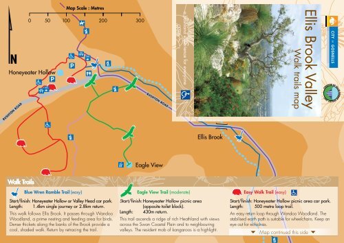
Map Scale : Metres0 50 100 200 300a bushland experience for everyone<strong>Ellis</strong> <strong>Brook</strong> <strong>Valley</strong><strong>Walk</strong> trails map<strong>Walk</strong> <strong>Trails</strong>Blue Wren Ramble Trail (easy)Start/finish: Honeyeater Hollow or <strong>Valley</strong> Head car park.Length: 1.4km single journey or 2.8km return.This walk follows <strong>Ellis</strong> <strong>Brook</strong>. It passes through WandooWoodland, a prime nesting and feeding area for birds.Dense thickets along the banks <strong>of</strong> the <strong>Brook</strong> provide acool, shaded walk. Return by retracing the trail.Eagle View Trail (moderate)Start/finish: Honeyeater Hollow picnic area(opposite toilet block).Length: 430m return.This trail ascends a ridge <strong>of</strong> rich Heathland with viewsacross the Swan Coastal Plain and to neighbouringvalleys. The resident mob <strong>of</strong> kangaroos is a highlight.Easy <strong>Walk</strong> Trail (easy)Start/finish: Honeyeater Hollow picnic area car park.Length: 500 metre loop trail.An easy return loop through Wandoo Woodland. Thestabilised earth path is suitable for wheelchairs. Keep aneye out for echidnas. Map continued this side
Map continued this side <strong>Walk</strong> trailsSixty Foot Falls Trail (difficult)Start/finish: <strong>Valley</strong> Head car park.Length: 2km loop trail.This walk reaches the top <strong>of</strong> the spectacularMap ScaleSixty: MetresFoot Falls,affording magnificent views <strong>of</strong> the <strong>City</strong> and <strong>Valley</strong> along the0 50 100 200 300way, before descending past the old Barrington Quarry where400 500old workings provide a window into the geology <strong>of</strong> the area.Map legend<strong>Ellis</strong> <strong>Brook</strong>Blue Wren Ramble1.4km or 2.8km (<strong>Walk</strong> trail)Sixty Foot Falls Trail 2km (<strong>Walk</strong> trail)Eagle ViewLink TrailEasy <strong>Walk</strong> Trail430m (<strong>Walk</strong> trail)500m (<strong>Walk</strong> trail)500m (Suitable for wheelchairs)Map Scale : Metres<strong>Ellis</strong> <strong>Brook</strong> to Bickley Reservoir 9km (Bridle/walk trail)0 50 100 200 300


