

OBSERVATION
CEOS EOHB tables June 2012 web - ceos eo handbook
CEOS EOHB tables June 2012 web - ceos eo handbook
- No tags were found...

Create successful ePaper yourself
Turn your PDF publications into a flip-book with our unique Google optimized e-Paper software.
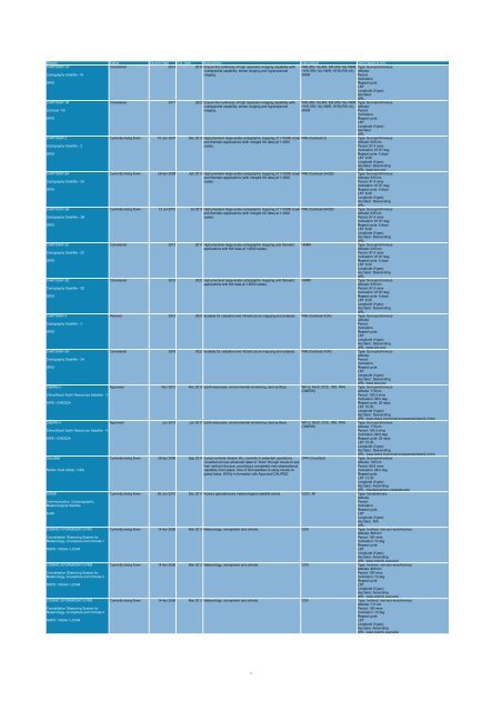
Mission Status Launch Date EOL Date Applications Instruments Orbit Details & URL<br />
CARTOSAT-1A<br />
Considered 2014 2019 Ensure the continuity of high resolution imaging capability with PAN (RS-1A)-MX, MX (RS-1A)-VNIR, Type: Sun-synchronous<br />
multispectral capability, stereo imaging and hyperspectral HYSI (RS-1A)-VNIR, HYSI (RS-1A)- Altitude:<br />
Cartography Satellite -1A<br />
imaging.<br />
SWIR<br />
Period:<br />
Inclination:<br />
ISRO<br />
Repeat cycle:<br />
LST:<br />
Longitude (if geo):<br />
Asc/desc:<br />
URL:<br />
CARTOSAT-1B<br />
Considered 2017 2022 Ensure the continuity of high resolution imaging capability with PAN (RS-1A)-MX, MX (RS-1A)-VNIR, Type: Sun-synchronous<br />
multispectral capability, stereo imaging and hyperspectral HYSI (RS-1A)-VNIR, HYSI (RS-1A)- Altitude:<br />
Cartosat -1B<br />
imaging.<br />
SWIR<br />
Period:<br />
Inclination:<br />
ISRO<br />
Repeat cycle:<br />
LST:<br />
Longitude (if geo):<br />
Asc/desc:<br />
URL:<br />
CARTOSAT-2<br />
Currently being flown 10 Jan 2007 Dec 2012 High precision large-scale cartographic mapping of 1:10000 scale PAN (Cartosat-2)<br />
Type: Sun-synchronous<br />
and thematic applications (with merged XS data) at 1:4000<br />
Altitude: 635 km<br />
Cartography Satellite - 2<br />
scales.<br />
Period: 97.4 mins<br />
Inclination: 97.87 deg<br />
ISRO<br />
Repeat cycle: 5 days<br />
LST: 9:30<br />
Longitude (if geo):<br />
Asc/desc: Descending<br />
URL: www.isro.org/<br />
CARTOSAT-2A<br />
Currently being flown 28 Apr 2008 Apr 2013 High precision large-scale cartographic mapping of 1:10000 scale PAN (Cartosat-2A/2B)<br />
Type: Sun-synchronous<br />
and thematic applications (with merged XS data) at 1:4000<br />
Altitude: 635 km<br />
Cartography Satellite - 2A<br />
scales.<br />
Period: 97.4 mins<br />
Inclination: 97.87 deg<br />
ISRO<br />
Repeat cycle: 5 days<br />
LST: 9:30<br />
Longitude (if geo):<br />
Asc/desc: Descending<br />
URL:<br />
CARTOSAT-2B<br />
Currently being flown 12 Jul 2010 Jul 2015 High precision large-scale cartographic mapping of 1:10000 scale PAN (Cartosat-2A/2B)<br />
Type: Sun-synchronous<br />
and thematic applications (with merged XS data) at 1:4000<br />
Altitude: 635 km<br />
Cartography Satellite - 2B<br />
scales.<br />
Period: 97.4 mins<br />
Inclination: 97.87 deg<br />
ISRO<br />
Repeat cycle: 5 days<br />
LST: 9:30<br />
Longitude (if geo):<br />
Asc/desc: Descending<br />
URL:<br />
CARTOSAT-2C<br />
Considered 2013 2017 High precision large-scale cartographic mapping and thematic HRMX<br />
Type: Sun-synchronous<br />
applications with MX data at 1:4000 scales.<br />
Altitude: 635 km<br />
Cartography Satellite - 2C<br />
Period: 97.4 mins<br />
Inclination: 97.87 deg<br />
ISRO<br />
Repeat cycle: 5 days<br />
LST: 9:30<br />
Longitude (if geo):<br />
Asc/desc: Descending<br />
URL:<br />
CARTOSAT-2D<br />
Considered 2016 2022 High precision large-scale cartographic mapping and thematic HRMX<br />
Type: Sun-synchronous<br />
applications with MX data at 1:4000 scales.<br />
Altitude: 635 km<br />
Cartography Satellite - 2D<br />
Period: 97.4 mins<br />
Inclination: 97.87 deg<br />
ISRO<br />
Repeat cycle: 5 days<br />
LST: 9:30<br />
Longitude (if geo):<br />
Asc/desc: Descending<br />
URL:<br />
CARTOSAT-3<br />
Planned 2015 2020 Suitable for cadastral and infrastructure mapping and analysis. PAN (Cartosat-3/3A) Type: Sun-synchronous<br />
Altitude:<br />
Cartography Satellite - 3<br />
Period:<br />
Inclination:<br />
ISRO<br />
Repeat cycle:<br />
LST:<br />
Longitude (if geo):<br />
Asc/desc: Descending<br />
URL: www.isro.org/<br />
CARTOSAT-3A<br />
Considered 2018 2023 Suitable for cadastral and infrastructure mapping and analysis. PAN (Cartosat-3/3A) Type: Sun-synchronous<br />
Altitude:<br />
Cartography Satellite - 3A<br />
Period:<br />
Inclination:<br />
ISRO<br />
Repeat cycle:<br />
LST:<br />
Longitude (if geo):<br />
Asc/desc: Descending<br />
URL: www.isro.org/<br />
CBERS-3<br />
Approved Nov 2012 Nov 2015 Earth resources, environmental monitoring, land surface. WFI-2, MUX, DCS , IRS, PAN Type: Sun-synchronous<br />
(CBERS)<br />
Altitude: 778 km<br />
China Brazil Earth Resources Satellite - 3<br />
Period: 100.3 mins<br />
Inclination: 98.5 deg<br />
INPE / CRESDA<br />
Repeat cycle: 26 days<br />
LST: 10:30<br />
Longitude (if geo):<br />
Asc/desc: Descending<br />
URL: www.cbers.inpe.br/en/programas/cbers3-4.htm<br />
CBERS-4<br />
Approved Jun 2014 Jun 2017 Earth resources, environmental monitoring, land surface. WFI-2, MUX, DCS , IRS, PAN Type: Sun-synchronous<br />
(CBERS)<br />
Altitude: 778 km<br />
China Brazil Earth Resources Satellite - 4<br />
Period: 100.3 mins<br />
Inclination: 98.5 deg<br />
INPE / CRESDA<br />
Repeat cycle: 26 days<br />
LST: 10:30<br />
Longitude (if geo):<br />
Asc/desc: Descending<br />
URL: www.cbers.inpe.br/en/programas/cbers3-4.htm<br />
CloudSat<br />
Currently being flown 28 Apr 2006 Sep 2013 3-year nominal mission life, currently in extended operations. CPR (CloudSat)<br />
Type: Sun-synchronous<br />
CloudSat will use advanced radar to "slice" through clouds to see<br />
Altitude: 705 km<br />
their vertical structure, providing a completely new observational<br />
Period: 98.8 mins<br />
NASA / DoD (USA) / CSA<br />
capability from space. One of first satellites to study clouds on<br />
Inclination: 98.2 deg<br />
global basis. Will fly in formation with Aqua and CALIPSO.<br />
Repeat cycle:<br />
LST: 13:30<br />
Longitude (if geo):<br />
Asc/desc: Ascending<br />
URL: cloudsat.atmos.colostate.edu/<br />
COMS<br />
Currently being flown 26 Jun 2010 Dec 2017 Korea's geostationary meteorological satellite series. GOCI, MI Type: Geostationary<br />
Altitude:<br />
Communication, Oceanographic,<br />
Period:<br />
Meteorological Satellite<br />
Inclination:<br />
Repeat cycle:<br />
KARI<br />
LST:<br />
Longitude (if geo):<br />
Asc/desc: N/A<br />
URL:<br />
COSMIC-1/FORMOSAT-3 FM1<br />
Currently being flown 14 Apr 2006 Mar 2013 Meteorology, ionosphere and climate. GOX Type: Inclined, non-sun-synchronous<br />
Altitude: 800 km<br />
Constellation Observing System for<br />
Period: 100 mins<br />
Meteorology, Ionosphere and Climate-1<br />
Inclination: 72 deg<br />
Repeat cycle:<br />
NSPO / NOAA / UCAR<br />
LST:<br />
Longitude (if geo):<br />
Asc/desc: Ascending<br />
URL: www.cosmic.ucar.edu/<br />
COSMIC-2/FORMOSAT-3 FM2<br />
Currently being flown 14 Apr 2006 Mar 2013 Meteorology, ionosphere and climate. GOX Type: Inclined, non-sun-synchronous<br />
Altitude: 800 km<br />
Constellation Observing System for<br />
Period: 100 mins<br />
Meteorology, Ionosphere and Climate-2<br />
Inclination: 72 deg<br />
Repeat cycle:<br />
NSPO / NOAA / UCAR<br />
LST:<br />
Longitude (if geo):<br />
Asc/desc: Ascending<br />
URL: www.cosmic.ucar.edu/<br />
COSMIC-3/FORMOSAT-3 FM3<br />
Currently being flown 14 Apr 2006 Mar 2013 Meteorology, ionosphere and climate. GOX Type: Inclined, non-sun-synchronous<br />
Altitude: 711 km<br />
Constellation Observing System for<br />
Period: 100 mins<br />
Meteorology, Ionosphere and Climate-3<br />
Inclination: 72 deg<br />
Repeat cycle:<br />
NSPO / NOAA / UCAR<br />
LST:<br />
Longitude (if geo):<br />
Asc/desc: Ascending<br />
URL: www.cosmic.ucar.edu/<br />
5


