Apr - Wasatch Mountain Club
Apr - Wasatch Mountain Club
Apr - Wasatch Mountain Club
- No tags were found...

Create successful ePaper yourself
Turn your PDF publications into a flip-book with our unique Google optimized e-Paper software.
Volume 92, Number 4<br />
The <strong>Wasatch</strong> <strong>Mountain</strong> <strong>Club</strong><br />
1390 S. 1100 E. #103<br />
Salt Lake City, UT 84105-2443<br />
(801) 463-9842<br />
2012-2013 GOVERNING BOARD<br />
President: John Veranth<br />
(278-5826) veranth@xmission.com<br />
Vice-President: Will McCarvill (942-2921)<br />
will@commercialchemistries.com<br />
Secretary: Vacant<br />
Treasurer:<br />
Co-director: John Butler<br />
(718-4166) john@utahman.com<br />
Co-director: Donovan Lynch<br />
((315-368-8522) donovanlynch@gmail.com<br />
Membership:<br />
Co-director: Eileen Gidley<br />
(870-5870) eileengidley@yahoo.com<br />
Co-director: Angie Vincent<br />
(281-3160)dvince182@yahoo.com<br />
Historian: Alexis Kelner<br />
(359-5387) kelner@xmission.com<br />
Biking:<br />
Co-director: Robert Turner<br />
(467-1129) r46turner@gmail.com<br />
Boating: Zig Sondelski<br />
(230-3623) zig.sondelski@gmail.com<br />
Conservation: Will McCarvill (942-2921)<br />
will@commercialchemistries.com<br />
Social:<br />
Co-director: Tony Hellman<br />
(809-6133) utahhomes4us@gmail.com<br />
Co-director: Helen Corena (561-0095)<br />
Hiking:<br />
Co-director: Julie Kilgore<br />
(244-3323) jk@wasatch-environmental.com<br />
Co-director: Liz Cordova<br />
(486-0909) liz1466@live.com<br />
Information Technology:<br />
Co-director: Bret Mathews<br />
(831-5940) bretmaverick999@yahoo.com<br />
Co-director: Bernard Rouse<br />
(435-882-4427) bernardrouse@q.com<br />
Public Relations: Chris Fraizer<br />
(262-7152) cbfraizer@comcast.net<br />
Lodge: Foundation Liaison, Bob Myers<br />
(466-3292) robertmyers47@gmail.com<br />
Caretaker: Todd Nerney<br />
caretakerwmc@yahoo.com<br />
Lodge Use: Earl Cook<br />
(580-6188) ecookut@hotmail.com<br />
<strong>Mountain</strong>eering:<br />
Co-director: Nathan Schweitz<br />
(942-0852) nathanschweitz@hotmail.com<br />
Co-director: Steve Duncan<br />
(474-0031) duncste@comcast.net<br />
Rambler Publications:<br />
Editor: Kathy Craig (502-0465)<br />
wasatchmountainclub@gmail.com<br />
Winter Sports: Walt Haas<br />
(209-2545) haas@xmission.com<br />
COORDINATORS:<br />
Adopt-a-Highway: Kathy Craig<br />
(502-0465) bugsismyguy@comcast.net<br />
Boating Equipment: Bret Mathews<br />
(831-5940) bretmaverick999@yahoo.com<br />
Canoeing: Margie Gendler<br />
(712-7890) gendler801@aol.com<br />
Canyoneering: Rick Thompson<br />
gone2moab@hotmail.com<br />
Evening Hikes: Mark Bloomenthal<br />
(842-1242) markbloomenthal@yahoo.com<br />
<strong>Mountain</strong> Biking: Cheryl Krusko<br />
(474-3759) ckrusko@gmail.com<br />
Rambler Graphics: Suzanne Nakagawa<br />
(362-8383)<br />
Rambler Mailing: Chris Venizelos<br />
(554-3697)<br />
Sing-a-Long: Fred Tripp<br />
(301-461-0161) fredgtripp@gmail.com<br />
Ski, Backcountry: Vacant<br />
Ski, Touring: Mike Berry<br />
(583-4721) mberryxc@earthlink.net<br />
Snowshoeing: Deirdre Flynn<br />
(466-9310) deirdre.flynn@marriott.com<br />
Trails: Dave Andrenyak<br />
(582-6106) andrenyakda@aim.com<br />
TRUSTEES:<br />
Dave Rumbellow 2010-2014<br />
(889-6016) djr3@xmission.com<br />
Cheryl Soshnik 2011-2015<br />
(435-649-9008) csoshnik@yahoo.com<br />
Gretchen Siegler 2012-2016<br />
(661-5635) gsiegler@westminstercollege.edu<br />
Barb Hanson 2013-2017<br />
(485-0132) barbhanson30@hotmail.com<br />
Trustee Emeritus:<br />
Dale Green (277-6417)<br />
The Rambler (USPS 053-410) is published<br />
monthly by the <strong>Wasatch</strong> <strong>Mountain</strong> <strong>Club</strong>.<br />
Subscription rates of $12.00 per year<br />
are paid for by membership dues only.<br />
Periodicals Postage Paid at SLC, Utah.<br />
CHANGE OF ADDRESS/Missing<br />
Rambler: Please call the WMC office or<br />
send your new address to the Membership<br />
Director. This publication is not<br />
forwarded by the Post Office. Allow 45<br />
days for address changes. Replacement<br />
copies are available, while they last, at the<br />
WMC office during office hours.<br />
POSTMASTER: Send address<br />
changes to: The Rambler, Membership<br />
Director, 1390 S. 1100 E, #103, Salt<br />
Lake City, UT 84105-2443.<br />
COMMERCIAL ADVERTISING:<br />
The Rambler encourages and<br />
supports your products and services<br />
through pre-paid commercial<br />
advertisements. Please send an e-mail<br />
to <strong>Wasatch</strong><strong>Mountain</strong><strong>Club</strong>@gmail.<br />
com for information or to place an ad.<br />
Prepayment is necessary for single<br />
month advertisements and invoicing<br />
and net 30 for repeat advertisements.<br />
Full Page: $95/month<br />
Half Page: $50/month<br />
Quarter Page: $30/month<br />
Business Card: $15/month<br />
The right is reserved to edit all<br />
contributions and advertisements,<br />
and to reject those that may harm the<br />
sensibilities of WMC members or<br />
defame the WMC.<br />
Copyright 2013 <strong>Wasatch</strong> <strong>Mountain</strong> <strong>Club</strong><br />
2
IN THIS ISSUE:<br />
The WMC Lodge . . . . . . . . . . . . . . . . 4<br />
2013-2014 WMC Governing Board. . 5<br />
Treasurer's Report . . . . . . . . . . . . . . 7<br />
Boating Director's Message . . . . . . 8<br />
Welcome to New Members . . . . . . .11<br />
Wilderness First Aid Basic/CPR . . . 17<br />
Faint Trails in the <strong>Wasatch</strong> . . . . . . .26<br />
Hike Rating Table . . . . . . . . . . . . . . .34<br />
Release of Liability Form . . . . . . . . .38<br />
Activities Listing . . . . . . . . . . . . . . . .40<br />
Non-WMC Activities . . . . . . . . . . . . .59<br />
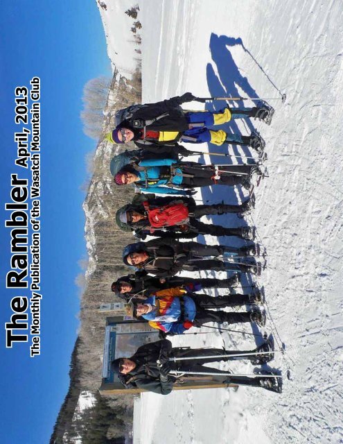
FRONT COVER:<br />
DEIRDRE FLYNN'S IDAHO YURT TRIP<br />
February 28-March 3, 2013<br />
L-R: JIM KUCERA, TRICIA LEE,<br />
SHANE BODE, JAQ BODE,<br />
MOHAMED ABDALLAH, DEIRDRE<br />
FLYNN AND DAVE RUMBELLOW<br />
AT THE TRAILHEAD<br />
MORE PHOTOS ON PAGES 14-16<br />
WASATCH<br />
MOUNTAIN CLUB<br />
Est. 1920<br />
The <strong>Wasatch</strong> <strong>Mountain</strong><br />
<strong>Club</strong>, formed in 1920, is<br />
an organization of outdoor<br />
enthusiasts who engage in<br />
recreational activities as well<br />
as social gatherings and<br />
conservation efforts.<br />
Check out our activities calendar and<br />
join us for an adventure!<br />
<strong>Club</strong> ACTIVITIES INCludE<br />
• Hiking, backpacking and camping<br />
• Flat and whitewater kayaking,<br />
canoeing and rafting,<br />
• <strong>Mountain</strong> and road biking,<br />
• Rock and ice climbing, canyoneering<br />
and mountaineering,<br />
• Snowshoeing,<br />
• Nordic & alpine backcountry skiing,<br />
• Social/entertainment activities/<br />
programs<br />
• Conservation pursuits<br />
FOR MORE INFORMATION VISIT<br />
WASATCHMOUNTAINCLUB.ORG<br />
INFO@WASATCHMOUNTAINCLUB.ORG<br />
3
IN THIS ISSUE:<br />
The WMC Lodge . . . . . . . . . . . . . . . . 4<br />
2013-2014 WMC Governing Board. . 5<br />
Treasurer's Report . . . . . . . . . . . . . . 7<br />
Boating Director's Message . . . . . . 8<br />
Welcome to New Members . . . . . . .11<br />
Wilderness First Aid Basic/CPR . . . 17<br />
Faint Trails in the <strong>Wasatch</strong> . . . . . . .26<br />
Hike Rating Table . . . . . . . . . . . . . . .34<br />
Release of Liability Form . . . . . . . . .38<br />
Activities Listing . . . . . . . . . . . . . . . .40<br />
Non-WMC Activities . . . . . . . . . . . . .59<br />
FRONT COVER:<br />
DEIRDRE FLYNN'S IDAHO YURT TRIP<br />
February 28-March 3, 2013<br />
L-R: JIM KUCERA, TRICIA LEE,<br />
SHANE BODE, JAQ BODE,<br />
MOHAMED ABDALLAH, DEIRDRE<br />
FLYNN AND DAVE RUMBELLOW<br />
AT THE TRAILHEAD<br />
MORE PHOTOS ON PAGES 14-16<br />
WASATCH<br />
MOUNTAIN CLUB<br />
Est. 1920<br />
The <strong>Wasatch</strong> <strong>Mountain</strong><br />
<strong>Club</strong>, formed in 1920, is<br />
an organization of outdoor<br />
enthusiasts who engage in<br />
recreational activities as well<br />
as social gatherings and<br />
conservation efforts.<br />
Check out our activities calendar and<br />
join us for an adventure!<br />
<strong>Club</strong> ACTIVITIES INCludE<br />
• Hiking, backpacking and camping<br />
• Flat and whitewater kayaking,<br />
canoeing and rafting,<br />
• <strong>Mountain</strong> and road biking,<br />
• Rock and ice climbing, canyoneering<br />
and mountaineering,<br />
• Snowshoeing,<br />
• Nordic & alpine backcountry skiing,<br />
• Social/entertainment activities/<br />
programs<br />
• Conservation pursuits<br />
FOR MORE INFORMATION VISIT<br />
WASATCHMOUNTAINCLUB.ORG<br />
INFO@WASATCHMOUNTAINCLUB.ORG<br />
3
wasatch <strong>Mountain</strong> <strong>Club</strong><br />
Treasurer's Report<br />
for year ended<br />
December 31, 2012<br />
During the year 2012 the <strong>Club</strong> received $31,387 in Member Dues, $611 in member donations, along with $211 in Interest Income.<br />
The following is the <strong>Club</strong>'s Statement of Operations for activities for the year 2012.<br />
Changes in Fund Balances Beginning Receipts Disbursements Ending<br />
General Fund 40,748 27,101 24,031 43,818<br />
Conservation 17,177 3,532 1,347 19,362 *<br />
WMC Foundation 399 3,361 3,654 106 *<br />
Alexis Kelner Conservation 1,727 20 - 1,747<br />
Boating 15,068 3,069 2,693 15,444<br />
<strong>Mountain</strong>eering 1,404 60 60 1,404<br />
Trail Promotion 40,836 255 193 40,898<br />
A. Kelly Memorial (& Bike Safety) 417 - - 417<br />
Robert Froehbose Winter Safety and Education 1,167 - - 1,167<br />
Bill Viavant Water Sports Education and Safety 2,065 10 840 1,235<br />
118,904 40,660 33,966 125,598<br />
Cash Receipts<br />
Amount<br />
Membership Dues 31,387<br />
Conservation 288<br />
WMC Foundation 744<br />
Alexis Kelner Conservation 20<br />
Boating 3,069<br />
<strong>Mountain</strong>eering 60<br />
Trail Promotion 255<br />
Bill Viavant Water Sports Education and Safety 10<br />
Interest Income 211<br />
Rambler Ads 970<br />
Misc Income 657<br />
Member Merchandise Clearing 2,989<br />
40,660<br />
* Receipts for Conservation Fund includes 10% allocation of memebership dues. Receipts for WMC<br />
Foundation fund includes 8% allocation of memebership dues. Both funds receive a 50% allocation of<br />
interest income<br />
Disbursements from General Fund<br />
Amount<br />
Office Rent/Utilities 5,183<br />
Website 13<br />
Credit Card Fees 1,299<br />
Tax & Corp Fees 10<br />
Office 142<br />
Rambler Printing 9,091<br />
Rambler Postage 1,800<br />
Membership 971<br />
Membership Meetings 39<br />
Publicity 890<br />
Social Events 3,242<br />
Boating 172<br />
Climbing 158<br />
Hiking 821<br />
Bicycling 200<br />
24,031<br />
7
2013 BOATING CALENDAR AS OF MARCH 8, 2013<br />
LAUNCH<br />
DATE<br />
TRIP<br />
CLASS<br />
RAPIDS ORGANIZER ORGANIZER CONTACT<br />
Mar 15 - 17 Black Canyon I<br />
Brucer<br />
Richardson bellcyn1@gmail.com<br />
Mar 22 - 24 Black Canyon I<br />
Dudley<br />
McIlhenny dudley.mcilhenny@gmail.com<br />
<strong>Apr</strong> 4 - 9 Dirty Devil>San Juan II Steve Pace stephencpace@alum.mit.edu<br />
<strong>Apr</strong> 19 - 21 Black Canyon I Eileen Gidley eileengidley@yahoo.com<br />
<strong>Apr</strong> 20 Boat Shed Opening 0 Bret Matthews bretmaverick999@yahoo.com<br />
May 18 - 19 Beginner Gray Canyon II Donnie Benson donnie.benson@u2m2.utah.edu<br />
Zig Sondelski zig.sondelski@gmail.com<br />
May 25 - 26 Beginner Moab Daily I Nicolle Wiaderny nwiaderny@gmail.com<br />
May 29 - ? San Juan II Kelly Beumer kelly@biochem.utah.edu<br />
Jun 1 - 2 Westwater IV- Nicolle Wiaderny nwiaderny@gmail.com<br />
Jun 5 - 8 Lodore III+ TBD Kevin Earl<br />
Jun 5 - 8 Lodore III+ TBD Luke Johnson<br />
Jun 12 - 15 Lodore III+ Zig Sondelski zig.sondelski@gmail.com<br />
Jun 12 - 16 Yampa III+ TBD June Wang<br />
Jun 12 - 18 Middle Fork Salmon IV+<br />
Dudley<br />
McIlhenny dudley.mcilhenny@gmail.com<br />
Jun 15 - 16 Sevier II TBD Max Snyder<br />
Jun 15 - Jul 1 Grand Canyon V Mark Grosser markjgrosser@yahoo.com<br />
Beginner Split<br />
Jun 22 - 23 <strong>Mountain</strong> III Kelly Beumer kelly@biochem.utah.edu<br />
Donnie Benson/Tony Hellman<br />
Jun 29 - 30 Flaming Gorge ?? I Nicolle Wiaderny nwiaderny@gmail.com<br />
Jul 4 - 7 Payette II Rick Thompson gone2moab@hotmail.com<br />
Jul 10 - 16 Main Salmon III<br />
Dudley<br />
McIlhenny dudley.mcilhenny@gmail.com<br />
Jul 13 - 14<br />
Beginner Split<br />
<strong>Mountain</strong> III Zig Sondelski zig.sondelski@gmail.com<br />
Barbara Boehme<br />
Jul 17 - 22 Desolation III Mike Bullinger mikebullinger@msn.com<br />
Jul 24 - 30 Main Salmon III TBD Erik Vogel<br />
Jul 26 - Aug 2 Main Salmon III TBD Bert Ley<br />
Aug 11 - 18 Cataract Canyon Motor IV- Bob Cady rcady@xmission.com<br />
?? Aug ?? Beginner Alpine III TBD<br />
Sep 13 - 18 Desolation III John Veranth veranth@xmission.com<br />
?? Sep ?? Cataract Service Proj IV TBD<br />
Sep 8 - 14 Stillwater Canyon II- Marjorie Gendler gendler801@aol.com<br />
Sep 27-Aug 3 Middle Fork Salmon IV TBD Alan Polumbos<br />
Sep TBD Boat Shed Closing 0 Bret Matthews bretmaverick999@yahoo.com<br />
??Oct?? Pink Flamingo 0 Cindy Crass<br />
8
oating director's message<br />
zig sondelski<br />
It looks like we have quite a boating season this<br />
year. We got at least one permit for every trip<br />
we applied for and permits for some other rivers<br />
showed up too. Thanks to all who made the effort<br />
and spent the few bucks to apply. First we applied<br />
for permits and waited<br />
for the results. Then we<br />
shared our prizes and<br />
built our schedule at the<br />
planning party on March<br />
5. Now, trip organizers<br />
step forward, people sign<br />
up, permits are paid for,<br />
plans made, reservations<br />
phoned in and equipment<br />
reserved. Also coming<br />
up is training for boaters<br />
and organizers. So, there<br />
is still more to do. And<br />
then, when the time<br />
comes, we go boating<br />
and all of the above is<br />
well worth it. YEAH!!!!<br />
If you would like to<br />
participate, please check<br />
the calendar for more<br />
river trip details.<br />
The <strong>Wasatch</strong> <strong>Mountain</strong> <strong>Club</strong> has a vibrant boating program and owns boats<br />
and gear to fully equip club boating trips. The club schedules a wide variety<br />
of trips from daily runs to weeklong river trips. Trips range in intensity from<br />
serene flat-water canoe trips to challenging class IV-V whitewater.<br />
BECOME A WMC MEMBER<br />
You can join or renew online or download a membership or<br />
renewal application. Go to www.wasatchmountainclub.org<br />
Questions? Email or call. We're happy to answer.<br />
9
Photos by<br />
Fred Schubert<br />
Ro b e r t G i n g ' s<br />
Winter Shelter Building/ Winter Camping<br />
Workshop<br />
Chuck, Steven Ging and<br />
Fred Schubert ready to<br />
dig out the Quinzee<br />
Chuck and Robert Ging, tools of the trade<br />
March 3, 2013<br />
Fred in a trench shelter<br />
Steven, Robert and<br />
Chuck – digging and<br />
hauling<br />
MARKETPLACE<br />
This space is reserved for those members placing ads for used and recreational gear<br />
or for private and non-commercial and not-for-profit activities. To submit an ad,<br />
e-mail it to wasatchmountainclub@gmail.com by the 10th of each month prior to<br />
publication. Non WMC members $5.00 up to 20 words, $0.20 per additional word.<br />
REMEMBER: There is also a “Gear Swap” area online where you can post what you are looking for,<br />
or place something that you want to sell or get rid of. It seems to be more up-to-date most of the<br />
time, due to the hard copy of the Rambler only being produced once a month.<br />
10
from the editor<br />
To achieve a high<br />
quality printed<br />
Rambler, I have<br />
been advised by<br />
our publisher to<br />
please avoid using<br />
camera phones<br />
to produce your<br />
pictures. Despite the<br />
high quality of the<br />
newer phones, when<br />
you start resizing<br />
the pictures, the<br />
quality drastically<br />
diminishes.<br />
Welcome New Members<br />
Kathy Jones<br />
Brad Ellis<br />
Holly Pruett<br />
Steven Johnson<br />
Jacen Wray<br />
Dorothy Weber<br />
Kevin Earl<br />
Lori Flygare<br />
Douglas Davis<br />
Ron Harris<br />
Melissa Bernstein<br />
Dan Gibbs<br />
Amy Christeson<br />
Brett Pralle<br />
Ken Whipple<br />
Cheryl Banks<br />
Nicole Thomas<br />
Nicholas Lumby<br />
Adele Kimbrough<br />
Christopher Spicer<br />
Michelle Savard<br />
John Marino<br />
Rita Pehrson<br />
Louis and Julie Melini<br />
Larry and Melody Turner<br />
David and Judy Keller<br />
Sanford and Hope Melville<br />
Darren Larsen and Maria Soriano<br />
Kate Little and Ron Tharp<br />
Marty and Darlene Erich<br />
Mark Balboni and Rachel Rogers<br />
11
12<br />
Join other <strong>Wasatch</strong><br />
<strong>Mountain</strong> <strong>Club</strong> members<br />
who volunteer to usher<br />
at Abravanel Hall,<br />
Capitol Theatre and Rose<br />
Wagner Center. See<br />
live performances by all<br />
your favorites without<br />
buying a ticket! When<br />
you usher, you’ll enjoy<br />
Broadway in Utah, Ballet<br />
West, Utah Symphony<br />
and Opera, RDT, Ririe<br />
Woodbury Dance,<br />
Plan-B Theatre, and<br />
performances like Wicked,<br />
Shrek, Nutcracker and<br />
Lion King. For more<br />
information and to sign<br />
up, go to www.slccfa.<br />
org and click on "Patron<br />
Services" or call 801-<br />
323-6816. Also ask<br />
WMC members and you<br />
will find quite a few who<br />
already usher. You pick<br />
your schedule and events<br />
each month. Orientation<br />
and excellent training will<br />
be starting in <strong>Apr</strong>il so<br />
don’t delay in signing up.
L a u r e n W a l t e r s c h e i d<br />
M a s t e r A e s t h e t i c i a n<br />
Tangles Salon & Day Spa<br />
7076 S. Highland Dr.<br />
801-424-2724<br />
801-656-8814 (cell)<br />
laurenwalterscheid@gmail.com<br />
Whether you’re preparing to bare all in a bikini, or<br />
just prefer a hair free lower body appearance, waxing<br />
removes hair in a way no other non-permanent method<br />
can. It leaves the skin clear of stubble and re-growth<br />
for weeks at a time, which can be more comfortable as<br />
well, especially if you're riding a bike! If you usually use<br />
a razor and are looking for a smoother, longer lasting<br />
result, a Brazilian wax might be just the solution.<br />
Gift Certificates Available<br />
Mention this ad and<br />
receive 20% off<br />
Valid only with Lauren<br />
Basic Bikini Wax - $30.00 Bikini Deluxe Wax - $38.00 Brazilian Wax - $50.00<br />
13
L-R: Jaq, Tricia, Deirdre,<br />
Jim, Dave and Shane on<br />
the way back<br />
Jim, Jaq,<br />
and Deirdre<br />
making dinner<br />
Inside the yurt - Shane,<br />
Dave, Tricia and Deirdre<br />
Photos by<br />
Deirdre Flynn and<br />
Mohamed Abdallah<br />
Beautiful view!<br />
On the way home<br />
(L-R: Mohamed, Shane,<br />
Jaq and Tricia)<br />
16
WWWWWWWWWW FFFFF AAA BBBBB<br />
CPR<br />
PPPPPPP AAAAAAAAAA ~ SSSSS ~ BBBBBBBB ~<br />
SSSSS IIIIIIII ~ FFFFFFFFF ~ DDDDDDDDDDDD<br />
BBBBB/SSSSSS ~ WWWWWWWWWW WWWWW MMMM<br />
~ CCCC-IIIIIII EEEEEEEEEEE<br />
HHHH-IIIIIII EEEEEEEEEEE ~ MMMMMMM<br />
FFFFF AAA KKKK ~ LLLLL IIIIII ~ CPR<br />
Location:<br />
WMC<br />
LODGE<br />
OOOO $99<br />
SAT.<br />
APRIL 6TH<br />
8AM-6PM<br />
_______________________________________<br />
WWWWWWWWWW FFFFF RRRRRRRRR<br />
OOOO $325 (WMC MMMMMMM OOOO)<br />
TTTT./TTTTT. EEEEEEEE, SSS. MMMMMMMM<br />
MMMMM MMMMM (MMMMM 555 - 2888)<br />
WWWWW: UUUU VVVVVV UUUUUUUUUU / LLLLL AAAA MMMM<br />
_______________________________________<br />
SSSSS LLLLLLL<br />
CCCC 801-360-5183<br />
FFF MMMM IIIIIIIIIII SSSS UU<br />
1222222222222222....<br />
NOTE: PLEASE LOOK FOR THIS CALENDAR POSTING FOR APRIL<br />
6TH IN THE ACTIVITIES LISTING AT THE BACK OF THIS ISSUE<br />
17
A n d y B e a r d &<br />
J u d e E l i z o n d o ' s<br />
D r y C r e e k C a n y o n S n o w s h o e<br />
Our ascent while in a good snow storm<br />
We got an intense snowstorm and no views or<br />
blue sky. Andy Beard, Jude Elizondo, Da Yang<br />
and Asha Patel heading down the canyon on a<br />
momentary break in the snowstorm.<br />
February 23, 2013<br />
Bruce: We opted out of the scheduled Pine Hollow to Tibble Fork hike because<br />
that hike is all about the views. The last three photos are from a previous Pine<br />
Hollow to Tibble Fork hike. The views were stunning! We knew we wouldn't be<br />
able to enjoy those fantastic views, so we opted for Dry Creek Canyon.<br />
18<br />
Had a momentary break,<br />
then a cloud layer moved<br />
in, back to no visibility!<br />
Got a break and posed for a picture.<br />
A barely visible Horsetail Falls in the<br />
backgorund. L-R: Andy, Jude, Asha<br />
and Da Yang.
L-R: Bruce, Da Yang, Asha, Jude and Andy<br />
A fun descent through<br />
some fresh new powder<br />
The very spectacular views that<br />
we knew we were not going to<br />
see (previous hike)<br />
<br />
Photos by<br />
Bruce Moore<br />
The killer views (previous hike)<br />
This is what<br />
we hoped for<br />
(previous hike)<br />
19
At the Dog Lake/Desolation Lake Trail<br />
junction (L-R: Dan Clark, Michael Budig,<br />
Dave Andrenyak and Tricia Lee)<br />
Dave Andrenyak's<br />
Snowshoe to<br />
Dog Lake<br />
At a viewpoint east of Dog Lake (L-R: Michael<br />
Budig, Tricia Lee, Dianne Budig and Dan Clark)<br />
January 24, 2013<br />
<br />
From just south of Dog Lake<br />
looking toward Reynolds Peak.<br />
It was a wonderful day to be in<br />
the <strong>Wasatch</strong> with a great group.<br />
Photos by Dave Andrenyak<br />
On August 12, 2012,<br />
three hikers climbed<br />
Neff’s Canyon, from 9:30<br />
to 12:30. This canyon<br />
offers a spectacular<br />
view of the valley and a<br />
refreshing pause in the<br />
shade. Because of the<br />
dry summer, there was<br />
no water in the stream<br />
or pond at the entrance.<br />
Vegetation was quite<br />
dry. The parking lot was<br />
full of cars, dogs, and<br />
people. The Jeep trail was<br />
Jaelene Myrup’s Neff ’s Canyon<br />
Artist’s Hike<br />
Photo by Richard Kimsey<br />
covered on both sides,<br />
every two feet, with dog<br />
feces. This is despite the<br />
free doggie bags at the<br />
trailhead entrance. We<br />
also passed residents<br />
who were carrying out<br />
debris, and concerned<br />
about the Forest Service<br />
allowing campfires in<br />
the area. Overall, it was<br />
an enjoyable morning.<br />
Participants: Richard<br />
Kimsey, Kathy Moran and<br />
Jaelene Myrup.<br />
20
We set up camp at Gold Strike Canyon.<br />
I was immediately impressed by the<br />
teamwork that went into getting<br />
everyone’s things off the canoes and<br />
on to shore. Rick, our trip organizer,<br />
designated a nearby spot for the<br />
community kitchen, and he was even<br />
kind enough to set up a community<br />
potty. However, (for the record) as<br />
nice as that was of him, this “newbie”<br />
personally managed to avoid the need.<br />
Anyway…. once set up, we followed Rick<br />
out to do some fairly light bouldering<br />
(which I only label as such because<br />
I managed to pull it off in my sister’s<br />
Teva sandals without injury). However,<br />
with that said, I think it’s important to<br />
note a few things at this stop. Anyone<br />
considering this trip should plan for wet,<br />
yet warm feet everywhere except in the<br />
comfort of your tent….for those who find comfort in a tent. Also, this particular trail is accessible by<br />
foot from the top of the canyon, so there was a bit more traffic and a lot more trash than I expected<br />
(see Trash Clean Up photos on Page 25). And yes, there are several inviting hot springs along<br />
the way, but I later learned that this is a designated nudist trail…. which is fine but that would have<br />
been nice to know “BEFORE” we came across the soaking naked guy!<br />
Our kitchen<br />
Setting up and breaking down camp was actually pretty easy, and the next morning we were off,<br />
paddling down river for Boy Scout Canyon. Here, the canyoneering got a bit more complicated,<br />
with lots of ropes, waterfalls, and rock slime. Eight of the 13 paddlers successfully passed the Rick<br />
Thompson Canyoneering Challenge, making it all the way to the box canyon at the top of the “trail.”<br />
Marcia Hansen rapelling<br />
Cheryl and Marsha stemming, while<br />
Martin, Jen and June wait their turn<br />
23
L-R: Julie, Cheryl, June, Marsha,<br />
Rick, Martin, Sal and Lori at the<br />
head of Boy Scout Canyon<br />
Back in the water and paddling downstream,<br />
we stopped at a canyon Rick hadn’t explored<br />
before. This turned out to be a simple hike up<br />
Moonscape Canyon, to a wonderful hot pool<br />
below a little waterfall. Our final destination<br />
Rick, Lori, Terri,<br />
Jen, Marsha<br />
and Cheryl in<br />
Moonscape Pool<br />
Kelly and Martin<br />
beneath the "Catwalk"<br />
for the day was the pull out for Arizona Hot<br />
Springs, where we set up camp and were<br />
supposed to hike up to yet another hot<br />
springs. But by this time, I was down to my<br />
last pair of dry shoes and was hot-springed<br />
out, opting instead for a glass of wine and a<br />
bit of down time.<br />
The last day was a nine-mile paddle to the<br />
take out at Willow Beach. Finally, we could<br />
dig into the water and test our<br />
strength and skills with the<br />
canoe. It was a strenuous haul<br />
that was made more difficult<br />
with the headwinds, but it was<br />
so peaceful, beautiful, and full of<br />
interesting remnants of pre-dam<br />
river management activities.<br />
For me, this was a great<br />
introduction to river tripping,<br />
canyoneering, camping, and<br />
all kinds of other non-hiking<br />
things. I could pass on the 12-<br />
hour poundings my sister seems<br />
to enjoy. But I want to do a lot<br />
more of this stuff!! (Submitted<br />
by Cheryl Williams)<br />
Entire group<br />
Rear: Kelly, Martin, Lori, Rick,<br />
Jen, Pam, Marsha, Cheryl and Sal<br />
Front: Julie, Terri, Judene and June<br />
24
We decided<br />
that burning<br />
the toilet<br />
paper was<br />
better than<br />
leaving it<br />
(picking it up<br />
was not an<br />
option)<br />
Martin rapels into<br />
a large crack to<br />
clean out a large<br />
trash cache<br />
Photos by<br />
Julie Kilgore<br />
and Kelly Beumer<br />
L-R: Martin, Rick and<br />
Kelly relay garbage<br />
down the boulders<br />
Julie gathers the smaller<br />
trash bags to transfer<br />
into the larger bag<br />
Julie Kilgore: The first of<br />
three Black Canyon boating/<br />
canyoneering trips was the first<br />
weekend of March. The group<br />
was a bit disappointed with<br />
the amount of trash in Gold<br />
Strike Canyon. After returning<br />
to camp from the afternoon<br />
canyoneering up to the hot<br />
springs, several clubbers<br />
headed back up the canyon to<br />
clean up the canyon.<br />
L-R: Julie, Rick, Kelly<br />
and Martin test their<br />
canyoneering skills<br />
with a trash haul!<br />
25
lift could still operate, but with a lighter load. It ran the rest<br />
of that day with skiers riding on every third chair. The gear<br />
was repaired before the third weekend of operations.<br />
Amenities and shelter for skiers were in short supply. The<br />
Forest Service was building a shelter that was still under<br />
construction at the time the ski lift began operation. It was<br />
located some distance to the east of the center of activity.<br />
Known shortly thereafter as the Rock Shelter, it was<br />
remodeled many years later to become the Snow Pine Lodge.<br />
But there was another shelter very close to the bottom of the<br />
ski lift. It was the old office building that once served the<br />
Columbus Consolidated Mining Company. By this time the<br />
compressor house had been torn down, leaving the office<br />
building as the only surviving structure. Still sporting its<br />
characteristic triple dormers on each side of the roof, it was<br />
given a respectable facade with a coat of red paint, possibly<br />
an inexpensive red barn paint. Also, it was given two large<br />
signs on the side facing the highway. The larger one<br />
advertised Coca Cola, but also gave the building’s name -<br />
Alta Ski Shelter. The smaller of the two signs promoted<br />
Royal Crown Cola. In its new role the building became<br />
known as the Red Shelter. It is not clear who was responsible<br />
for the remodeling to serve in its new role. It received<br />
practically no attention in the press, but there have been<br />
suggestions that the food that was available was prepared by<br />
Bertha Howard. She had been the cook at the Balsam Inn at<br />
Brighton when it burned down in March of 1937, and in 1941<br />
was the manager at the Alpine Rose lodge, also in Brighton.<br />
The third Sunday of the lift’s operation practically ended<br />
its season, for the day ended as a heavy snowstorm arrived.<br />
That was followed by storm after storm. Massive avalanches<br />
destroyed a number of buildings and badly damaged the<br />
Forest Service shelter. Snow removal equipment was<br />
primitive when compared to what is available today, so the<br />
highway was not opened all the way to Alta until mid-March,<br />
at which time trenches had to be dug in the snow to allow the lift chairs to pass through. Photographs taken that<br />
day show that the day was very warm, most likely indicating the ski season, the very first, albeit brief ski season<br />
at Alta was rapidly coming to a close.<br />
The Red Shelter served skiers for another season. By that time the Forest Service Rock Shelter was being<br />
repaired and was in limited service, and the<br />
Alta lodge had been built. The Red Shelter<br />
was then converted to a private home by<br />
Dick Durrance, a nationally known ski racer<br />
who moved to Alta to take over the ski<br />
school. He and his wife spent several months<br />
remodeling the building, then only lived in it<br />
for a few weeks in January of 1941 before it<br />
caught fire and burned to the ground, taking<br />
with it all their possessions, including his<br />
collection of medals and trophies. An<br />
overheated stove was blamed for setting the<br />
home ablaze while its residents were having<br />
Fig. 3. Photo taken on 19 March 1939, the first day of ski lift operation after<br />
nearly two months of heavy snow storms and destructive avalanches kept the<br />
canyon closed. The remains of a large aerial tramway tower destroyed in an<br />
avalanche is at the upper left. The road is still in the process of being opened. The<br />
Red Shelter, in the center of the photo between the lift terminal and the road,<br />
escaped without damage.<br />
Fig. 2. The Red Shelter, formerly the office building of the<br />
Columbus Consolidated Mining Company. Notice the three<br />
dormers on each side of the roof. The base of the new Alta ski<br />
lift is across the bottom of the canyon. Collins Gulch is above<br />
and Mount Baldy is on the skyline.<br />
dinner at the adjacent Alta Lodge. It was as<br />
if the building, a relic of the mining era, was<br />
bowing out to let the new era, that of winter<br />
recreation, take over.<br />
. . . . . . . © Faint Trails by Charles L. Keller . . . . . .<br />
.<br />
27
Death Valley Winter Escape<br />
February 6-10, 2013<br />
Cheryl: This year's<br />
Bob Wright Memorial<br />
Death Valley Winter<br />
Escape was from<br />
February 6-10,<br />
2013. Thirty had<br />
signed up, 27<br />
showed up. The first<br />
day, upon arrival,<br />
the temperature<br />
was 79 degrees...<br />
yippee. Here we are<br />
on Thursday a.m.,<br />
getting briefed by<br />
ride master Rick<br />
Kirkland as to the<br />
rides and hikes<br />
offered for the day.<br />
We scrambled and hiked to the end point<br />
at this pour off, had lunch in the sun and<br />
then hiked back the way we came (L-R:<br />
Cheryl Soshnik and Eve Bertran-Hales)<br />
Eve Bertran-Hales and Don Hales<br />
hiking in Mosaic Canyon<br />
28
Tonight's dinner was<br />
chili, supplemented with<br />
dutch oven corn bread<br />
and brownies. The<br />
whole group chipped in<br />
to help make the dinner,<br />
making light work and<br />
delicious dinners.<br />
Gerrish Willis and Rob Paull<br />
waiting for dinner<br />
Ride<br />
Master<br />
Rick<br />
Kirkland<br />
Donna Smith, Chris<br />
Karcher and Katie Slack<br />
preparing the salad<br />
29
Our tents were protected inside a tamarisk<br />
forest. You just had to watch your head as you<br />
came out of the tents because of low laying<br />
branches.<br />
Saturday was warmer and a<br />
perfect day for bike riding.<br />
Quite a few of us biked from<br />
Furnace Creek to Stovepipe<br />
Wells and back, just about 50<br />
miles and almost no hills.<br />
Dave getting ready to<br />
head back to camp<br />
Heading back to<br />
camp...you can see<br />
the road goes on<br />
forever, and not much<br />
elevation change. The<br />
ride was almost all<br />
below sea level!<br />
Photos by<br />
Cheryl Soshnik<br />
Date Palms at the<br />
Golf Course at<br />
Furnace Creek<br />
30
K n i c k K n i c k e r b o c k e r ' s<br />
W i l l o w L a k e t o B e a r t r a p S n o w s h o e<br />
Dave Rumbellow<br />
starting at the<br />
Willow Lake trailhead<br />
January 24, 2013<br />
F-B: Dave<br />
Rumbellow,<br />
Henri<br />
DeBaritault,<br />
Jimmie Boyd,<br />
Mohamed<br />
Abdallah and<br />
Jaq Bode<br />
6-10 inches of nice<br />
and soft FRESH snow!<br />
Shane Bode<br />
breaking trail<br />
for us as we<br />
head toward<br />
Willow Lake<br />
Jimmie Boyd<br />
with Willow<br />
Lake behind<br />
us below<br />
L-R: Carol Masheter,<br />
Mohamed, Dave<br />
and Shane<br />
Photos<br />
by<br />
Knick<br />
Knickerbocker<br />
32
Shane, Mohamed<br />
and Henry heading<br />
up the ridge<br />
Almost to the<br />
top of the ridge<br />
Our lunch spot in the sun<br />
Mohamed on top of his mountain<br />
After lunch we<br />
headed down into<br />
Beartrap Fork into<br />
the trees and deep<br />
powder snow<br />
Here we gooooooo! Yahoo!!<br />
33
34<br />
Hike Rating (Revised Mar 21, 1993, by Dale Green)<br />
These ratings are a mathematical calculation derived by giving 1 point for every 1,000 feet of ascent and<br />
adding 0.3 points for every round trip (RT) miles. Extra points are added for off-trail miles (bushwhacking),<br />
exposure (high-angle scrambling), and elevations over 10,000 feet.<br />
RT Total Max<br />
Hike Description<br />
Rating<br />
Miles Ascent Elev<br />
Pipeline, v. Burch Hollow to Church Fork 0.7 1.90 0 6000<br />
Pipeline, v. Elbow Fork to Burch Hollow 0.9 2.19 0 6620<br />
Doughnut Falls 1.1 1.55 360 7820<br />
Pipeline, v. Church Fork to Burch Hollow 1.1 1.90 300 6000<br />
Secret Lake from Albion Basin Campground 1.2 1.67 420 9860<br />
Willow Lake 1.4 1.61 600 8500<br />
Solitude, Lake, v. Silver Fork 1.5 2.76 310 9040<br />
Pipeline, v. Church Fork to Rattlesnake Gulch 1.6 3.11 300 5990<br />
Pipeline, v. Burch Hollow to Elbow Fork 1.6 2.19 600 6620<br />
Stairs Gulch to 6700’ 1.7 1.44 900 6700<br />
Mary, Lake, from BLTH 1.8 2.06 750 9540<br />
Catherine Pass v. Albion Basin 1.9 2.11 790 10220<br />
Twin Lakes v. Silver Lake 1.9 2.42 730 9460<br />
Pipeline, v. Rattlesnake Gulch to Church Fork 1.9 3.12 550 5990<br />
Elbow Fork to Terraces TH 2.0 2.67 740 7370<br />
Mill B, NF Overlook 2.1 2.29 900 7120<br />
Pipeline, SL Valley viewpoint v. Rattlesnake Gulch 2.1 3.59 540 5980<br />
Broads Fork to bridge 2.2 2.33 960 7160<br />
Dry Lake v. Willow Lake 2.3 2.75 920 8820<br />
City Creek Twin Peaks# 2.3 2.20 1090 6291<br />
Greens Basin v. housing road 2.3 3.34 770 8330<br />
Terraces TH to Elbow Fork 2.5 2.67 1120 7370<br />
Soldier Fork to BCC divide 2.5 2.11 1290 8890<br />
Mule Hollow to mine 2.5 2.41 1200 7020<br />
Greens Basin v. Days Fork 2.5 3.13 990 8330<br />
Solitude Loop, v. Silver L, L Solitude, Twin Lakes 2.5 3.85 790 9620<br />
Wilson Fork to 8900’* 2.7 2.31 1400 8900<br />
Van Cott Peak v. Cephalopod Gulch ridge# 2.8 2.30 1350 6348<br />
Evergreen, Mt., v. Silver Lake 2.8 3.39 1120 9620<br />
Catherine, Lake, v. BLTH & old trail 2.8 3.33 1150 9940<br />
Terraces TH to summit 2.8 3.52 1120 7370<br />
Cardiff Pass from Alta 2.9 2.82 1370 10020<br />
Sunset Peak v. Albion Basin 3.0 3.29 1220 10648<br />
Bald <strong>Mountain</strong> (Uinta Mtns.)# 3.0 2.80 1180 11943<br />
Honeycomb Fork to Woodlawn Mine v.ski track 3.0 3.71 1210 9280<br />
Dog Lake v. old BWT 3.1 3.76 1240 8780<br />
Catherine, Lake, v .BLTH & Lake Mary 3.1 4.08 1150 9940<br />
Dog Lake v.LWT 3.1 3.80 1240 8780<br />
Twin Lakes Pass v. Silver Lake 3.2 4.24 1220 9993<br />
Red Butte Peak v. Georges Hollow# 3.3 3.30 1510 6472<br />
Elbow - Lambs Pass v. Elbow Fork 3.3 3.39 1500 8130<br />
Elbow Fork to Lambs Canyon 3.3 3.43 1500 8130<br />
Lambs Canyon to Elbow Fork 3.3 3.43 1510 8130<br />
Twin Lakes Pass v. Grizzly Gulch from Alta 3.3 4.07 1320 9993<br />
Salt Lake Overlook, v. B.S. shortcut, Deso Trail 3.3 4.28 1270 7020<br />
Elbow - Lambs Pass v. Lambs Canyon 3.3 3.49 1510 8130<br />
White Fir Pass v. Terraces, Bowman Fork 3.4 3.52 1530 7590<br />
Pipeline, v. Elbow Fork to SL View, dn Rattlesnake 3.4 8.77 0 6620<br />
Circle All Peak v. Butler Fork 3.4 3.46 1610 8707<br />
Snake Creek Pass v. BLTH & Majestic Trail 3.5 4.33 1350 10080<br />
Tolcat Creek Crossing (Mt Olympus trail) 3.5 4.22 1400 6240<br />
Pencil Point# 3.5<br />
Salt Lake Overlook, v. Desolation Trail 3.6 4.87 1270 7020<br />
Red Butte Pass v. Georges Hollow# 3.6 3.70 1640 6600<br />
Honeycomb Fork to Woodlawn Mine v. Silver Fork 3.6 5.20 1210 9280<br />
Bowman Fk > Elbow Fk > upper Pipeline loop 3.6 4.91 1310 7370<br />
Dog Lake v. old Mill D, NF trail 3.6 4.63 1400 8730<br />
Cardiff Mine v. Cardiff Fork 3.7 4.96 1350 8810<br />
Baldy, Mt., v. Secret Lake, Germania Pass 3.7 4.08 1630 11068<br />
Dog Lake v. new Mill D, NF trail 3.8 4.75 1460 8730<br />
Sugarloaf v. Secret Lake saddle 3.8 3.50 1610 11051<br />
Millicent, Mt., v.ski lift road & ridge 3.8 3.50 1710 10452<br />
Alexander Basin to 9000’ 3.8 3.38 1910 9000<br />
Reynolds Peak v.LWT 3.8 3.80 1820 9422
Park West Overlook v. BWTH & cyn bottom trail 3.9 5.56 1330 8930<br />
Sugarloaf v. Germania Pass 3.9 3.97 1610 11051<br />
Flagstaff Mtn. v. Alta & jeep trail* 4.0 3.34 1880 1530<br />
Aire, Mt., v. Elbow Fork 4.0 3.59 2000 8621<br />
Greens Basin Trail to trail’s end 4.0 4.53 740 9080<br />
Reynolds Peak v. old BWT 4.1 4.47 1820 9422<br />
Dog Lake v. new BWT 4.2 6.54 1240 8780<br />
Honeycomb Cliffs v. Silver Lake, Twin Lks Pass# 4.2 4.92 1750 10479<br />
Catherine Pass v. Lake Mary 4.3 4.77 1860 10220<br />
Alexander Basin trail to Terraces TH v. Bowman Fk. 4.3 5.44 1710 8600<br />
Devils Castle v. Albion Basin Camp (Exposure) 4.4 3.77 1490 10930<br />
Big Beacon (Wire Peak) from zoo parking lot# 4.5 3.70 2240 7143<br />
Silver Fork to mines 4.5 6.16 1580 9650<br />
Broads Fork to meadow 4.5 4.76 2040 8240<br />
Burch Hollow to Mill Creek - Parleys Ridge 4.6 4.64 2120 8140<br />
Perkins Peak# 4.6 4.20 2290 7490<br />
Park West Overlook v. BWTH & GWT 4.6 7.47 1330 8930<br />
Big Beacon (Wire Peak) v. Georges Hollow# 4.7 4.70 2180 7143<br />
Little Water Peak v. old BWT* 4.7 5.36 2005 9605<br />
Little Water Peak v.LWT* 4.7 5.40 2005 9605<br />
Dog Lake v. Butler Fork 4.7 6.28 1740 8780<br />
Pioneer Peak v. BLTH, Catherine Pass* 4.7 3.39 2460 10430<br />
Thayne Cyn Spring v. Deso Trail 4.9 5.78 2000 7710<br />
Sunset Peak v. BLTH & Lake Mary 4.9 5.96 1860 10648<br />
Mineral Fork to <strong>Wasatch</strong> Mine 4.9 6.06 1950 8660<br />
Millvue Peak v. Elbow Fork 4.9 4.96 2300 8926<br />
Majestic, Mt, (Clayton Pk) v. BLTH & Majestic Trail 4.9 5.89 1930 10721<br />
Hounds Tooth# 5.0 3.60 2600 7800<br />
Silver Fork to end of Days Fork trail* 5.0 6.61 1870 9940<br />
Desolation Peak (9990’) v. Beartrap Fork 5.1 4.96 2430 9990<br />
Stansbury Island Peak (no trail)# 5.1 5.00 2420 6645<br />
Reynolds Peak v. new Mill D, NF trail 5.2 6.11 2150 9422<br />
Reynolds Peak v. new BWT 5.2 7.25 1820 9422<br />
Red Pine Lake from WPTH 5.2 6.93 1930 9630<br />
Reynolds Peak Traverse, up Mill D, dn Butler Fk 5.3 6.55 2150 9422<br />
Mineral Fork to Silver Mtn. Mine 5.4 4.99 2620 9330<br />
Tuscarora-Wolverine Peaks from BLTH* 5.4 5.80 2090 10795<br />
Desolation, Lake, v. Mill D, NF 5.4 7.28 1970 9240<br />
Bowman Fork to Alexander Basin TH 5.4 5.44 2550 8600<br />
Broads Fork to trail’s end (8600’) 5.5 5.99 2400 8600<br />
Days Fork to Eclipse Mine 5.5 6.61 2260 9600<br />
Church Fork Pk Traverse, v. Burch Hol dn Church Fk 5.5 6.00 2290 8306<br />
Aire, Mt., from gate, v. road, Elbow Fork 5.6 5.85 2530 8621<br />
Maybird Lakes from WPTH 5.6 7.52 2050 9750<br />
Monte Cristo Mine v. Cardiff Fork 5.6 7.37 2100 9560<br />
Church Fork Peak v. Church Fork 5.7 5.81 2620 8306<br />
Kessler Peak v. Cardiff Fk., north trail 5.7 4.89 2940 10403<br />
Reynolds Peak v. Butler Fork 5.7 6.99 2320 9422<br />
Blanche, Lake 5.7 6.06 2600 8920<br />
Little Water Peak v. new BWT* 5.8 8.14 2005 9605<br />
Grandeur Peak v. Church Fork 5.8 6.28 2610 8299<br />
Church Fk Pk Loop, v. Brch Hol, dn Ch. Fk, pipeline 5.9 7.07 2290 8306<br />
Church Fork Pk Traverse, v. Church Fk dn Burch Hol 5.9 6.00 2620 8306<br />
Aire, Mt., v. Elbow Fk, ret. v. Burch Hol, pipeline 6.0 6.79 2560 8621<br />
Kessler Peak v. Carbonate Mine trail 6.1 5.89 2940 10403<br />
Thayne Peak v. Thayne Canyon 6.1 6.08 2890 8640<br />
Gobblers Knob v. Alexander Basin Trail* 6.1 4.44 3155 10246<br />
Grandeur Peak v. West Ridge# 6.1 4.60 3340 8299<br />
Cardiff Pass v. Cardiff Fork (Mill D, SF) 6.1 7.24 2550 10010<br />
Park City Overlook v. BWTH & cyn bottom trail 6.2 8.78 2100 9700<br />
Mill Creek - Neffs Saddle v. Thayne Canyon 6.2 6.01 3000 8750<br />
Deaf Smith Canyon fm USFS boundary to meadow 6.3 5.96 3020 8400<br />
Desolation Peak (9990’) v. Mill D>L.Deso>dn Brtrap 6.3 7.09 2720 9990<br />
Days Fork to Little Cottonwood Cyn ridge 6.5 7.88 2600 9940<br />
Thayne Canyon to Neffs Canyon TH 6.5 6.73 3000 8850<br />
Murdock Peak v. BWTH up stream-bottom trail 6.7 7.11 3000 9602<br />
Church Fk Pk Loop, v. Ch. Fk, dn Brch Hol, pipeline 6.7 7.90 2620 8306<br />
Hayden Peak (Uinta Mtns.) (Exposure)# 6.7 5.80 2120 12479<br />
Porter Fork Saddle v. Porter Fork 6.7 7.93 2790 9360<br />
Neffs Canyon to Thayne Canyon BETH 6.8 6.73 3200 8550<br />
Superior, Mt., from Alta (exposure)# 6.9 5.00 3000 11050<br />
Park City Overlook v. BWTH, GWT & old trail 6.9 10.69 2100 9700<br />
35
Dry Hollow (Holladay) to BCC overlook (pk. 8498)* 7.0 5.99 3380 8498<br />
Mill Creek - Neffs Saddle v. Neffs Canyon 7.1 7.46 3200 8550<br />
Aire, Mt., v. Burch Hol, ridge, dn Elbow Fk, road 7.2 7.80 3190 8621<br />
Raymond, Mt., v. Butler Fork, Deso Trail 7.2 8.08 3140 10241<br />
Raymond - Gobblers saddle v. Bowman Fk. 7.3 8.38 3100 9350<br />
Gobblers Knob v. Butler Fork, Deso Trail 7.3 8.30 3145 10246<br />
Wheeler Peak (Snake Range, Nevada)# 7.3 7.40 2960 13063<br />
Lookout <strong>Mountain</strong> v. Killyon Canyon# 7.4 8.00 2950 8952<br />
Murdock Peak v. BWTH & GWT 7.4 9.02 3000 9602<br />
Little Black <strong>Mountain</strong> v. Twin Peaks# 7.4 9.60 2830 8026<br />
White Pine Lake v. WPTH 7.5 10.21 2670 10170<br />
Aire, Mt., v. Burch Hol, ridge, dn Elbow, pipeline 7.5 8.52 3190 8621<br />
Notch Peak (House Range) v. Sawtooth Canyon# 7.5 8.40 2960 9655<br />
Emerald Lake (Mt. Timpanogos, v. Aspen Grove)# 7.6 7.50 3510 10360<br />
Neffs Canyon to BCC saddle 7.6 7.47 3620 9190<br />
Monte Cristo Peak v. Alta# 7.7 5.60 3420 11132<br />
American Fork Twin Pks fm Albion Basin (Exposure)# 7.7 7.80 2590 11498<br />
Lone Peak Cirque v. Lone Rock (end of jeep road) 7.8 7.65 3440 10340<br />
Olympus, Mt., North Peak (Exposure, Climbing)# 7.8 4.80 3360 8959<br />
Thayne Peak v. Deso Trail 7.9 10.39 2930 8640<br />
Deseret Peak (Stansbury Mtns.)# 8.0 8.00 3610 11031<br />
Brighton Ridge Run fm Snake Crk Pass to Millicent# 8.1 7.50 3480 10975<br />
Big Black <strong>Mountain</strong> from Mueller Park# 8.4 9.60 3560 8958<br />
Aire, Mt., v. Burch Hollow, ridge, same return 8.4 9.08 3750 8621<br />
Desolation Trail, lower, up Porter Fk, to BETH 8.5 12.24 2840 9360<br />
Mill B, South Fork to upper mine prospect 8.5 8.30 4000 10320<br />
Olympus, Mt., South Peak, v. Tolcat Cyn 8.6 7.98 4200 9026<br />
Bells Canyon Reservoir (upper) v. lower reservoir 8.6 9.41 3810 9400<br />
Mineral Fork to Regulator Johnson Mine 8.7 10.45 3530 10240<br />
Mill Creek Ridge, Mt Aire-Grandeur, stay on ridge 8.8 10.30 3280 8621<br />
Nebo, Mt., North Peak v. Nebo Basin Trail# 8.8 9.00 3330 11928<br />
Ben Lomand v. North Ogden Cyn.# 8.9 11.00 3530 9712<br />
Storm <strong>Mountain</strong> v. Ferguson Gulch* 8.9 8.12 4280 9524<br />
Raymond, Mt., v. Hidden Falls & S. ridge* 9.0 8.77 4010 10241<br />
Raymond, Mt., v. Bowman Fork 9.1 10.00 3990 10241<br />
Gobblers Knob v. Bowman Fork 9.2 10.21 4000 10246<br />
Bells Canyon Reservoir (upper) v.LCC water tank 9.4 10.14 4160 9400<br />
Box Elder Peak from American Fork Canyon# 9.6 9.60 4340 11101<br />
Mill Creek Ridge, Mt Aire - Grandeur, on trails 9.6 10.71 4010 8621<br />
Pfeifferhorn v. Red Pine Lake# 9.6 10.00 3700 11326<br />
Sundial Peak v. Lake Blanche (Exposure)# 9.7 9.40 4000 10320<br />
Lone Peak v. Lone Rock (end of jeep road)# 10.1 9.42 4350 11253<br />
Spanish Fork Peak v. Right Fork, Maple Canyon# 10.3 11.00 4570 10192<br />
Raymond, Mt., v. Hidden Falls & N. ridge 10.4 12.55 4210 10241<br />
Lone Peak Cirque v. Jacobs Ladder (from main road)* 10.7 11.08 4620 10340<br />
Timpanogos, Mt., v. Aspen Grove# 11.1 11.40 4850 11750<br />
Dromedary Peak v. Lake Blanche (Exposure)# 11.2 9.40 4800 11107<br />
Monte Cristo Peak v. Lake Blanche# 11.2 10.20 4810 11132<br />
Lone Peak Cirque v. Draper Ridge# 11.4 11.91 4920 10340<br />
Timpanogos, Mt., v. Timpooeke# 11.5 14.00 4390 11750<br />
Twin Peaks v. Broads Fork# 11.5 10.20 5130 11330<br />
Nebo, Mt., South Peak v. Andrews Ridge# 11.6 12.00 5000 11877<br />
Lone Peak v. Jacobs Ladder (from main road)# 13.0 12.67 5530 11253<br />
The Beatout Hike (Red Pine Cyn to Bells Cyn)# 13.5 14.00 4780 11326<br />
Desolation, Lake, v. Deso Trail fm BETH, dn Mill D 13.6 17.30 5260 9240<br />
Lone Peak v. Draper Ridge# 13.7 13.51 5830 11253<br />
#Wildcat Ridge (Mt. Raymond to Mt. Olympus)# 14.9 14.00 5620 10242<br />
Abbreviations:<br />
* - Most of trail length determined by measuring wheel GWT - Great Western Trail<br />
# - Most of trail length estimated from topographic map LCC - Little Cottonwood Canyon<br />
BCC - Big Cottonwood Canyon<br />
LWT - Little Water Trail<br />
BETH - Box Elder Trail Head (also called Desolation Trail Head) TH - Trail Head<br />
BLTH - Brighton Lakes Trail Head<br />
v. - via<br />
BWT - Big Water Trail<br />
WPTH - White Pine Trail Head<br />
BWTH - Big Water Trail Head<br />
Deso - Desolation<br />
36
wasatch <strong>Mountain</strong> <strong>Club</strong> (wMC)<br />
Applicant Agreement, Acknowledgment of Risk, and Release from Liability<br />
Activity: _____________________________ Organizer: _______________________________ Date: ___________<br />
vOLUNTARy PARTICIPATION: I acknowledge that my participation in all WMC activities is voluntary. No one is<br />
forcing me to participate. I agree to abide by the rules of the WMC.<br />
ASSUMPTION OF RISk: I am aware that WMC activities involve risks, and may result in injury, illness, death, and<br />
damage to or loss of property. These dangers include but are not limited to: the hazards of traveling in remote areas<br />
without medical services or care, the forces of nature, the inherent dangers involved in participation in sports, wilderness<br />
travel, and social activities, and the negligent actions of other persons or agencies. I understand that all activities should<br />
be considered exploratory, with the possibility of unexpected conditions and route variations. The WMC is not, nor does<br />
it provide, a professional guide service. In order to partake in the enjoyment and excitement of WMC activities, I am<br />
willing to accept the risk and uncertainty involved as being an integral part of the activity. I acknowledge this risk, and<br />
assume full responsibility for any and all risks of injury, illness, death, or damage to or loss of my property.<br />
PREPARATION: I understand that it is my responsibility to evaluate the difficulties of any WMC activity I participate in,<br />
and decide whether I am prepared by having the experience, skill, knowledge, equipment, and the physical and<br />
emotional stamina to participate safely.<br />
RELEASE OF LIABILITy AND PROMISE NOT TO SUE: I agree that I, my heirs, personal or legal representatives<br />
hereby do release and hold harmless from all liability, and promise not to bring any suit or claim against the WMC, its<br />
activity organizers, directors, agents or representatives for any injury, illness, death or damage and loss of property<br />
resulting from my participation in any WMC activity even if they negligently caused the injury or damage.<br />
LEGAL FEES: Should it become necessary for the WMC, or someone on their behalf, to incur attorney fees and costs<br />
to enforce this agreement, I agree to pay the WMC reasonable costs and fees thereby expended, or for which liability is<br />
incurred.<br />
INSURANCE: I understand that the WMC strongly recommends that I maintain insurance sufficient to cover any injury,<br />
illness or property damage that I may incur while participating in WMC activities. In the event of injury, illness or death<br />
related to any WMC activity, I recognize that I, or my estate, will bear the full cost of my evacuation or recovery, and any<br />
related medical care that I may need. I acknowledge that the WMC carries no insurance whatsoever for any participants<br />
in WMC activities.<br />
My signature below indicates I have read this entire document, understand it completely, understand it affects<br />
my legal rights, and agree to be bound by its terms. I certify I am at least 18 years old.<br />
38 Revised10/12/2008<br />
**ATTENTION** IF yOU ARE NOT A MEMBER OF THE wMC, PLEASE NOTIFy THE TRIP ORGANIZER!<br />
Member<br />
(Y/N) Signature Print Name Phone<br />
Check<br />
Out<br />
____ ____________________ ______________________ _______________ ____<br />
____ ____________________ ______________________ _______________ ____<br />
____ ____________________ ______________________ _______________ ____<br />
____ ____________________ ______________________ _______________ ____<br />
____ ____________________ ______________________ _______________ ____<br />
____ ____________________ ______________________ _______________ ____<br />
____ ____________________ ______________________ _______________ ____<br />
____ ____________________ ______________________ _______________ ____<br />
____ ____________________ ______________________ _______________ ____<br />
____ ____________________ ______________________ _______________ ____<br />
____ ____________________ ______________________ _______________ ____<br />
____ ____________________ ______________________ _______________ ____<br />
____ ____________________ ______________________ _______________ ____<br />
____ ____________________ ______________________ _______________ ____<br />
Return this form to <strong>Wasatch</strong> <strong>Mountain</strong> <strong>Club</strong>, 1390 South 1110 East, Salt Lake City, UT 84105-2443<br />
Please mark attention to the appropriate activity director, e.g., hike, bike, boat.
WASATCH MOUNTAIN CLUB ACTIVITIES<br />
Only activities approved by the appropriate WMC director can be listed in The Rambler. Direct submissions to the<br />
Editor are NOT accepted. To submit your activity to the club, login to the WMC website and click on “Volunteer to<br />
Organize An Activity”. The appropriate director will approve and/or edit this event for inclusion in both the web calendar<br />
and Rambler submissions. The deadline is 6:00 p.m. on the 10th of the month.<br />
Rules and Regulations:<br />
1. Dogs & Children are not allowed on WMC activities, except when specifically stated in the activity description.<br />
2. Car pool rates: Gas plus $0.15/mile, shared by everyone in the vehicle (including driver) on 2WD roads, OR gas plus<br />
$0.25/mile on 4WD roads.<br />
Notice to Non-Members: Most WMC activities are open to prospective members except when specifically stated in<br />
the activity description.<br />
Find out about unofficial activities on our email lists. Activities formed with these lists are for members only. Lists<br />
are to be used only for the scheduling of outdoor activities. Any use of this service for any other purpose, such as<br />
advertising, SPAM, jokes, etc, will result in the loss of privilege. To subscribe: Once logging into the website, click<br />
on “Email Lists” on the left-hand side. Then follow the online instructions. (Boaters: E-mail the Boat Director—inside<br />
front cover—for more information.)<br />
Group size limits in wilderness: Some National Forest ranger districts limit the size of gropus hiking in wilderness<br />
areas. For such hikes, the hike listing will indicate the maximum number of participants (not including the organizer).<br />
Please help our organizers on hikes with group size limits by arriving promptly and being understanding if you cannot<br />
be accommodated on the hike because of a limit.<br />
Activity Difficulty Rating<br />
0.1-4.0 > Not Too Difficult (NTD) B > Boulder fields or extensive bushwhacking<br />
Lightly Strenuous<br />
E > Elevation change > 5,000 feet<br />
4.1-8.0 > Moderate (MOD) M > Round trip mileage > 15 miles<br />
Moderate to Very Strenuous<br />
R > Ridgeline hiking or extensive route finding<br />
8.1-11.0 > Most Difficult (MSD) S > Scrambling<br />
Very Strenuous, Difficult<br />
X > Exposure<br />
11.1+ > Extreme (EXT) W > Wilderness area, limit 14<br />
Very Strong, Well-Seasoned Hikers<br />
Be kind. When you<br />
carpool up local<br />
canyons, please give<br />
the driver $1.50 or<br />
$2.00 to help with<br />
gas and the wear and<br />
tear on the vehicle.<br />
Directions to Meeting Places<br />
Mill Creek Canyon Park and Ride Lot: Between 3800 S and 3900 S on <strong>Wasatch</strong> Blvd (3555 E), between the I-215<br />
freeway and <strong>Wasatch</strong> Blvd along 3900 S. It is on the northwest corner of the intersection. You can ONLY enter it<br />
from the west-bound lanes of 3900 S. To get to the Mill Creek Canyon Rd from the Park and Ride lot without making<br />
a U-turn, go west (right) on 3900 S, proceed under the freeway, then turn north (right) at the next available street,<br />
which is Birch Dr; proceed north to Upland Dr (across from Skyline High School); go east (right) under the freeway<br />
and across <strong>Wasatch</strong> Blvd to the Mill Creek Canyon Rd (3800 S).<br />
Skyline High School: 3251 E Upland Drive (3760 S). From the intersection of <strong>Wasatch</strong> Blvd and the Mill Creek Canyon<br />
Rd (3800 S), go west under the I-215 freeway, then turn north (right) into the entrance opposite Birch Dr (3330 E).<br />
Butler Elementary: 2700 E just south of 7000 S<br />
Big Cottonwood Canyon Park and Ride Lot: At the northeast corner of the Big Cottonwood Canyon Rd and <strong>Wasatch</strong><br />
Blvd. at the mouth of Big Cottonwood Canyon.<br />
6200 Park and Ride Lot: 6450 S <strong>Wasatch</strong> Blvd. Go two lights east and south on 6200 S from the I-215 overpass and<br />
turn east (left) onto <strong>Wasatch</strong> Blvd; the lot is immediately on your left. Sometimes used as an overflow lot for access<br />
to Big Cottonwood Canyon.<br />
Ft. Union Lot #4: 200 yards west of Big Cottonwood Canyon Park & Ride, near the Porcupine Pub & Grille (which is<br />
located at 3698 Ft. Union Blvd).<br />
Little Cottonwood Canyon Park and Ride Lot: 4323 E Little Cottonwood Canyon Rd. On the north side of the intersection<br />
of Little Cottonwood Canyon Rd and Quarry Rd at the mouth of Little Cottonwood Canyon.<br />
Utah Travel Council Parking Lot: About 120 E 300 N. Go east from the intersection of State St and 300 N and turn<br />
south (right) into the first parking lot.<br />
Parleys Way K-Mart Parking Lot: 2705 Parleys Way. From Parleys Way, turn north into the parking lot; or from Foothill<br />
Drive, turn west on Stringham Ave (2295 S) and then south into the lot.<br />
39
ACTIVITIES LISTING<br />
See online Calendar for updated and additional events and trips<br />
Date<br />
Mar 31<br />
Sun<br />
Mar 31<br />
Sun<br />
Mar 31<br />
Sun<br />
Activity<br />
Road Bike: Farmington – mod – 52.0 mi Out & Back<br />
Meet: 9:00 am at Sugarhouse Park near the 15th East Entrance<br />
Organizer: Elliott Mott 801-969-2846 elliott887@msn.com<br />
This is a 52 mile Easter ride out and back to Farmington from Sugarhouse Park to add length to the traditional<br />
Farmington ride. We’ll zip through the University, roll across the Avenues and spin north along the Jordan River<br />
and Legacy Highway Trails. We’ll take a break at Harmon’s before returning. Meet Elliott (801-969-2846) in side<br />
Sugarhouse Park near the 15th East Entrance at 9:00am.<br />
Spike Hike<br />
Meet: Disseminated via the Hike email list<br />
Organizer: Liz Cordova liz1466@live.com<br />
If conditions allow, let’s hike! Check the hike email list or club website for last-minute details.<br />
Snowshoe: Organizer’s Choice – mod<br />
Meet: 9:00 am at 6200 South & <strong>Wasatch</strong> Park & Ride<br />
Organizer: Mohamed Abdallah 801-466-9310 agm1144@yahoo.com<br />
Join Mohamed for today’s MOD level snowshoe. He will choose an appropriate destination based on the conditions<br />
of the day. Participants should know how to travel safely in avalanche terrain, are expected to contribute<br />
to group discussions regarding avalanche safety and carry the appropriate safety equipment.<br />
Mar 31<br />
Sun<br />
<strong>Apr</strong> 2<br />
Tue<br />
<strong>Apr</strong> 3<br />
Wed<br />
<strong>Apr</strong> 3<br />
Wed<br />
Stansbury Island Day Hike – mod- – 2.0 mi – 2000’ ascent – Moderate pace<br />
Meet: 9:00 am at Utah Travel Council Lot - 110 E 300 N<br />
Organizer: Donn Seeley 801-706-0815 donn@xmission.com<br />
Let’s go scramble over the quartzite crags on Stansbury Island and enjoy the fantastic view over the Great Salt<br />
Lake. This hike may be exploratory depending on the whim of the organizer. You can expect steep slopes, and<br />
cross-country hiking and scrambling; high-top boots are recommended.<br />
Climbing Meeting/social, Kick-off Meeting – ntd-<br />
Meet: 6:30 pm at The Pie, 7186 S. Union Park Ave, Midvale<br />
Organizer: Steven Duncan 801-680-9236 duncste@comcast.net<br />
Join us for some season planning and we’ll get some climbs on the calendar. The pizza & soda is on us, adult<br />
beverages available. Please RSVP so we know about how many to expect.<br />
Mt Olympus Mid-week Day Hike – msd- – 7.5 mi Out & Back – 4200’ ascent – Moderate pace<br />
Meet: 8:00 am at Mount Olympus trailhead on <strong>Wasatch</strong> Blvd<br />
Organizer: Dennis Goreham 801-550-5169 dgoreham@gmail.com<br />
Microspikes or yaktrax are often handy on <strong>Apr</strong>il ascents of Olympus. There is a bit of scrambling toward the top<br />
of this steep hike.<br />
Governing Board Meeting<br />
Meet: 7:00 pm at 1390 South 1100 East, Suite 101<br />
Organizer: John* Veranth 801-278-5826 veranth@xmission.com<br />
<strong>Apr</strong>il Meeting - routine business<br />
40
<strong>Apr</strong> 3<br />
Wed<br />
<strong>Apr</strong> 4<br />
Thu<br />
<strong>Apr</strong> 4<br />
Thu<br />
<strong>Apr</strong> 5<br />
Fri –<br />
<strong>Apr</strong> 7<br />
Sun<br />
Evening Dog Hike: Mill Creek Canyon – ntd<br />
Meet: 6:00 pm at Skyline High School - 3151 E Upland Dr (3760 S)<br />
Organizer: Tom Silberstorf 801-255-2784<br />
Well mannered dogs along with their well mannered owners are welcome. Please bring water for yourself and<br />
your four-footed friend and poop bags for your dog. Please bring a leash in case circumstances arise where it<br />
is needed. This hike is open to the dog-less as well. The hike will be conducted at a turtle pace. There will be a<br />
prompt 6:15 pm departure.<br />
Alpine Ski Tour - At, Snowboard Or Telemark – mod – Out & Back – Moderate pace<br />
Meet: Registration required<br />
Organizer: Robert Myers 801-466-3292 (H) or 801-651-9965 (C) robertmyers47@gmail.com<br />
THURS. BACKCOUNTRY SKI TOUR: “DEPENDING ON SPRING CONDITIONS” this is a weekly MOD (moderate)<br />
ski tours. Destination generally in Big or Little Cottonwoods Canyons and dependent on weather and snow<br />
conditions. This is not a beginner ski tour and requires good conditioning, skiing skills and familiarity with your<br />
equipment. To participate you must have a beacon, shovel, probe and the knowledge of how to use them. Call<br />
or e-mail Robert by WED. evening, for the meeting place & time to verify that there will be a tour. Lack of snow<br />
may force cancellation Group limited to 8.<br />
Early Evening Hike - Ferguson Canyon – ntd+ – Out & Back – Fast pace<br />
Meet: 5:30 pm at Big Cottonwood Canyon Park & Ride<br />
Organizer: Julie Kilgore 801-244-3323 jk@wasatch-environmental.com<br />
Dogs and dog-less are welcome. This canyon is protected, so there is likely to be some patches of snow. Come<br />
prepared with warm clothes and possibly Yak Tracks for these early Spring hikes. Dogs OK<br />
Canyoneering 201 – mod<br />
Meet: Registration required<br />
Organizer: Rick Thompson gone2moab@hotmail.com<br />
Several new canyoneering routes have been laid out in Capitol Reef in the last few years, so its time for a club<br />
trip to explore some of them. Only a three hour drive from SLC, CR is a scenic and colorful area, with a nice developed<br />
campsite in the park, so you are not going primitive camping a la north wash. We will be driving down<br />
friday after work, and coming home sunday. The routes run towards the not very complicated or difficult. This<br />
trip is full on paper, but I will establish a wait list to fill in for possible cancellations.<br />
<strong>Apr</strong> 5<br />
Fri –<br />
<strong>Apr</strong> 7<br />
Sun<br />
Boulder Ut Car Camp<br />
Meet: Registration required<br />
Organizer: John* Veranth 801-278-5826 veranth@xmission.com<br />
Spring open weekend at Veranth’s cabin in Boulder. Format: Carpool as desired, daily activities organized based<br />
on participant interests and skills, potluck dinner on Saturday. Indoor plumbing and kitchen available. Register<br />
to get logistics sheet. Cabin will be available Thursday evening through Monday so schedule is flexible.<br />
<strong>Apr</strong> 6<br />
Sat<br />
Road Bike: Rose Canyon – mod – 52.0 mi Loop<br />
Meet: 9:00 am at Taylorsville Recreation Center, 4948 South 2700 West<br />
Organizer: Elliott Mott 801-969-2846 elliott887@msn.com<br />
This 52 mile ride showcases Rose Canyon in the southwest corner of Salt Lake Valley. Our course loops through<br />
Daybreak and returns along a scenic section of the Jordan River Parkway Trail. Plan on a gentle climb of about<br />
1800 feet as we ascend from Taylorsville to the gate entrance to Salt Lake County’s Yellow Fork Park in Rose<br />
Canyon. If the trail around Oquirrh Lake is snow free we’ll spin around it on our way to Rose Canyon, adding an<br />
additional 6 miles. Plan on stopping for lunch on the return. Meet Elliott (801-969-2846) at Taylorsville Recreation<br />
Center, 4948 South 2700 West at 9:00am.<br />
41
<strong>Apr</strong> 6<br />
Sat<br />
<strong>Apr</strong> 6<br />
Sat<br />
<strong>Apr</strong> 6<br />
Sat<br />
<strong>Apr</strong> 6<br />
Sat<br />
<strong>Apr</strong> 7<br />
Sun<br />
<strong>Apr</strong> 7<br />
Sun<br />
Slow Pace Hike - City Creek Twin Peaks From Shriners Hospital – mod- – Slow pace<br />
Meet: 10:00 am at Popperton Park (east of 11th Avenue and Virginia Street)<br />
Organizer: Co-Organizers Randy Long and Kathy Craig 801-733-9367 or 801-502-0465<br />
This is a fairly new twist to an old favorite. This hike will follow the Bonneville Shoreline Trail from Shriners Hospital,<br />
up a canyon and to a pass with panoramic views, then leveling out for about one mile before meeting the<br />
original route.<br />
Members Only: Basic Wilderness First Aid Training And Cpr<br />
Meet: 8:00 am at <strong>Wasatch</strong> <strong>Mountain</strong> <strong>Club</strong> Lodge<br />
Organizer: Dan Christopherson, <strong>Wasatch</strong> Emergency Medical Training 801-360-5183 dan@12fingeradventure.<br />
com<br />
<strong>Wasatch</strong> Emergency Medical Training has partnered with the WMC to provide a one-day Basic Wilderness First<br />
Aid training and CPR. The training will be held at the WMC lodge from 8 a.m. to 6 p.m. The discounted rate for<br />
WMC members is $99 per person, and will be an additional half price ($49.50) for any member who has organized<br />
over 10 activities in the last two years (or 5 multi-day out-of-town trips). Morning snacks and beverages<br />
will be provided. For now, plan to bring your own lunch, though our social directors are looking into a possible<br />
sponsor for lunch. Class size is limited to 25, and payment must be recieved by <strong>Wasatch</strong> Emergency Medical<br />
Training to secure your spot.<br />
Road Bike, My St. George Century – ext – 104.0 mi Out & Back – 5500’ ascent – Moderate pace<br />
Meet: Registration required<br />
Organizer: Greg Orzechowski 801-652-8214 gregomtb@gmail.com<br />
My St. George Century. Starts and ends at snow canyon campsite. From snow canyon drops down south and follows<br />
hw 18 north through Veyo, Enterprise, Loops through Newcastle and comes back on hwy 18 going south.<br />
Very scenic and interesting route with little traffic on average. I prefer this route which I tracked and did first<br />
time last October to official century ride that leads though build up areas for more than half of its distance. 104<br />
miles 5500 ft elevation gain (1 day). Expected average moving speed 15+ m/hr. Start, Saturday, <strong>Apr</strong>il 6, 8 am.<br />
Each participant is responsible for pre-arranging his/her support vehicle (I can help with that). Greg, 801-652-<br />
8214, gregomtb@gmail.com.<br />
Hike: West Desert: Ntd+ Mod- Rating<br />
Meet: 9:00 am at Utah Travel Council Lot - 110 E 300 N<br />
Organizer: Jerry Hatch 801-583-8047 pikahatch@gmail.com<br />
Exact destination will depend on weather, trail conditions and the group. Call Jerry for more information.<br />
Hike Mount Olympus – msd – 7.5 mi Out & Back – 4200’ ascent – Moderate pace<br />
Meet: 8:00 am at 6200 South & <strong>Wasatch</strong> Park & Ride<br />
Organizer: Julie Kilgore 801-244-3323 jk@wasatch-environmental.com<br />
Weather kept us from the summit back in February, so let’s give it another try. Expect icy snow leading up to the<br />
saddle, so bring yak trax or microspikes for good traction, especially on the descent.<br />
Silver Island Range Day Hike – mod+ – 5.0 mi – 2500’ ascent – Moderate pace<br />
Meet: 9:00 am at We’ll meet at the TA Travel Center at the Tooele exit from I-80 (exit 99, for SR 36; go south on<br />
SR 36 across the I-80 overpass and turn left in a hundred yards at the TA sign).<br />
Organizer: Donn Seeley 801-706-0815 donn@xmission.com<br />
Let’s go hike and scramble to a peak in this insanely rugged little mountain range just north of Wendover. There<br />
are spectacular views of the salt flats and Pilot Peak. We’ll drive northeast along the southern flank of the<br />
range, and hike up Campbell Peak from Jenkins Canyon. You can expect steep slopes, loose rock, and crosscountry<br />
hiking and scrambling; high-top boots are recommended.<br />
42
<strong>Apr</strong> 7<br />
Sun<br />
<strong>Apr</strong> 7<br />
Sun<br />
Hike: Big Beacon – mod – 4.0 mi Out & Back – 2350’ ascent<br />
Meet: 10:00 am at Meet at the trailhead across from Hogle Zoo<br />
Organizer: Phyllis Anderson 801-733-4806 paisnow@comcast.net<br />
This steep hike will be at a slow to moderate pace. If faster hikers want to participate, they can do so provided<br />
they coordinate with Phyllis at the trailhead to establish a second organizer for the faster group. Check the website<br />
for last minute updates and trail conditions/gear suggestions.<br />
Road Bike: Parley’s Crossing – ntd – 13.0 mi Loop<br />
Meet: 10:00 am at Sugarhouse Park, 1500 East 2100 South, Salt Lake City<br />
Organizer: Elliott Mott 801-969-2846 elliott887@msn.com<br />
This short social ride showcases the nifty paved bike paths at the mouth of Parley’s Canyon. Launching from<br />
Sugarhouse Park, we’ll drop down and spin through Parley’s Nature Preserve on a paved bike path crossing over<br />
to the west Grandeur trail head at the north end of <strong>Wasatch</strong> Boulevard. From there we’ll zig back north across<br />
Parley’s Canyon on another paved bike path to Foothill Drive where we’ll ride north to Hogle Zoo through a<br />
residential area. We’ll stop for warm-up drinks/brunch/lunch at the Corner Café & Bakery before returning to<br />
Sugarhouse Park. The paved bike paths have a couple of tight corners and a few short steep ramps. Meet Elliott<br />
(801-969-2846) inside Sugarhouse Park immediately west of the 15th East entrance at 10am.<br />
<strong>Apr</strong> 7<br />
Sun<br />
<strong>Apr</strong> 8<br />
Mon<br />
<strong>Apr</strong> 9<br />
Tue<br />
<strong>Apr</strong> 10<br />
Wed<br />
<strong>Apr</strong> 11<br />
Thu<br />
Hike: T B A – ntd<br />
Meet: Disseminated via the Hike email list<br />
Organizer: TBA TBA<br />
Check online to find out if anyone is organizing a liesurely NTD hike today.<br />
Fast-paced Hike Up Cherry Canyon To One-hour-rock. – ntd+ – Out & Back – Fast pace<br />
Meet: 5:30 pm at Orson Smith Trail Head (12601 South 2000 East)<br />
Organizer: Julie Kilgore 801-244-3323 jk@wasatch-environmental.com<br />
The hike up Cherry Canyon is a short steep workout to a spot Julie calls “one-hour-rock.” Dogs on leash (to the<br />
forest service boundary) ok.<br />
Evening Hike: Organizer’s Choice, Little Cottonwood Canyon – ntd<br />
Meet: 6:00 pm at Little Cottonwood Canyon Park & Ride<br />
Organizer: Brett Smith 801-580-2066<br />
There will be a prompt 6:15 pm departure.<br />
Evening Hike: Organizer’s Choice, Little Cottonwood Canyon – ntd<br />
Meet: 6:00 pm at Little Cottonwood Canyon Park & Ride<br />
Organizer: Brett Smith 801-580-2066<br />
There will be a prompt 6:15 pm departure.<br />
Alpine Ski Tour - At, Snowboard Or Telemark – mod – Out & Back – Moderate pace<br />
Meet: Registration required<br />
Organizer: Robert Myers 801-466-3292 (H) or 801-651-9965 (C) robertmyers47@gmail.com<br />
THURS. BACKCOUNTRY SKI TOUR: “DEPENDING ON SPRING CONDITIONS” this is a weekly MOD (moderate)<br />
ski tours. Destination generally in Big or Little Cottonwoods Canyons and dependent on weather and snow<br />
conditions. This is not a beginner ski tour and requires good conditioning, skiing skills and familiarity with your<br />
equipment. To participate you must have a beacon, shovel, probe and the knowledge of how to use them. Call<br />
or e-mail Robert by WED. evening, for the meeting place & time to verify that there will be a tour. Lack of snow<br />
may force cancellation Group limited to 8.<br />
43
<strong>Apr</strong> 11<br />
Thu<br />
Evening Dog Hike - Millcreek Canyon<br />
Meet: 6:00 pm at Skyline High School - 3151 E Upland Dr (3760 S)<br />
Organizer: Jean Acheson 801-633-5225 jachwest@comcast.net<br />
Well mannered dogs along with their well mannered owners are welcome. The dog-less are welcome as well.<br />
This hike is geared for all levels of hiking ability and will be conducted at a leisurely pace so we can enjoy the<br />
evening. Please bring water for yourself and any accompanying four-footed friends. Also, regardless of the leash<br />
law and day of the month, please bring a leash in case circumstances arise where it is needed. It is also recommended<br />
to bring a flashlight, warm clothes and possibly Yak Tracks for these early Spring hikes as there may still<br />
be snow or ice on the trails and we will be out until sunset. There will be a prompt 6:15 pm departure.<br />
<strong>Apr</strong> 11<br />
Thu<br />
<strong>Apr</strong> 12<br />
Fri –<br />
<strong>Apr</strong> 14<br />
Sun<br />
Evening Hike: The Living Room – ntd<br />
Meet: 6:00 pm at Corner of Tabby Lane and Colorow Drive in University Research Park<br />
Organizer: Anne Polinsky 801 466-3806<br />
Directions to meeting place: Exit Foothill Blvd. at Wakara Way; go northeast to the stop at Chipeta Way; go<br />
straight, then turn southeast (right) on Colorow Drive. Park about 50 yards past the intersection with Tabby<br />
Lane. There will be a prompt 6:15 pm departure.<br />
Yellowstone Hike-paced Bike Ride – 30.0 mi Out & Back – Slow pace<br />
Meet: Registration required<br />
Organizer: Julie Kilgore 801-244-3323 jk@wasatch-environmental.com<br />
Join Julie for her annual pre-season road bike trek in to Yellowstone the weekend before the park is open to<br />
cars. The park service is preparing for the season so the roads will be plowed, but being flexible is key. Plan A is<br />
a SLOW MEANDERING bike ride from West Yellowstone to Terrace Springs (about 4 hours for a 30 mile round<br />
trip). Plan B will be dictated by whatever Mother Nature is dishing out that morning. Come prepared for every<br />
combination of sun/snow/rain/wind/hot/cold. Base camp is Julie’s cabin in Island Park, which can hold about 12<br />
people. Additional lodging is available in West Yellowstone.<br />
<strong>Apr</strong> 13<br />
Sat<br />
<strong>Apr</strong> 13<br />
Sat<br />
<strong>Apr</strong> 14<br />
Sun<br />
Nordic Ski Tour: Organizer’s Choice – msd – 25.0 mi Out & Back – Fast pace<br />
Meet: Registration required<br />
Organizer: Michael Berry 801-583-4721 mberryxc@earthlink.net<br />
Cross-country skiing. Mirror Lake Hwy, Daniel’s Summit loop, or North Slope Uintas. Classic, skating, or light<br />
backcountry gear depending on weather and interest.<br />
Day Hike Little Black <strong>Mountain</strong> – mod – 10.0 mi Loop – 2830’ ascent – Moderate pace<br />
Meet: 10:30 am at Jewish Community Center (across from University Hospital)<br />
Organizer: Gabe Atiya 385-212-9854 gabeatiya@yahoo.com<br />
Fun spring hike. May be some patches of snow and scrub oak.<br />
Hike: Grandeur From Church Fork – mod – 6.0 mi Out & Back – 2620’ ascent<br />
Meet: 9:30 am at Skyline High School - 3151 E Upland Dr (3760 S)<br />
Organizer: Phyllis Anderson 801-733-4806 paisnow@comcast.net<br />
This spring classic will be at a slow to moderate pace. If faster hikers want to participate, they can do so provided<br />
they coordinate with Phyllis at the trailhead to establish a second organizer for the faster group. Check the<br />
website for last-minute updates and trail conditions/gear suggestions.<br />
44
<strong>Apr</strong> 14<br />
Sun<br />
<strong>Apr</strong> 14<br />
Sun<br />
Road Bike: <strong>Mountain</strong> View Corridor – ntd+ – 39.0 mi Loop<br />
Meet: 9:00 am at Taylorsville Recreation Center, 4948 South 2700 West, Taylorsville<br />
Organizer: Elliott Mott 801-969-2846 elliott887@msn.com<br />
This 39 mile course features a scenic section of the Jordan River Parkway Trail at the south end of the Salt Lake<br />
Valley and the new <strong>Mountain</strong> View Corridor highway on the west. We’ll loop south on the Parkway and return<br />
north on <strong>Mountain</strong> View. This course has a mild 3 mile climb at the south end of the valley by Camp Williams,<br />
but mostly easy flat to rolling terrain everyplace else. This ride has no official lunch stop but we’ll stop at convenience<br />
stores sprinkled along the course. Meet Elliott (801-969-2846) at Taylorsville Recreation Center, 4948<br />
South 2700 West, at 9:00am.<br />
Hike: Muellar Park To North Canyon – ntd – 7.0 mi Loop – Moderate pace<br />
Meet: Disseminated via the Hike email list<br />
Organizer: Liz Cordova 801-486-0909 liz1466@live.com<br />
Liz and Sadie Wolfe will co-organize this Bountiful hike, most likely meeting at the North Canyon trailhead, but<br />
check the website or email list for specifics and more information. Relaxed moderate pace.<br />
<strong>Apr</strong> 16<br />
Tue<br />
<strong>Apr</strong> 17<br />
Wed<br />
<strong>Apr</strong> 17<br />
Wed<br />
Evening Hike: Organizer’s Choice, Mill Creek Canyon – ntd<br />
Meet: 6:00 pm at Skyline High School - 3151 E Upland Dr (3760 S)<br />
Organizer: Michelle and Woib Butz 801 842-9646 mbutz27@yahoo.com<br />
There will be a prompt 6:15 pm departure.<br />
Evening Hike: Killyon Canyon – ntd<br />
Meet: 6:00 pm at The parking area across Sunnyside Ave. from Hogle Zoo.<br />
Organizer: Jerry Hatch 801-583-8047<br />
Join Jerry for a hike up this seldom visited canyon. There will be a prompt 6:15 pm departure.<br />
Evening Dog Hike: Mill Creek Canyon – ntd<br />
Meet: 6:00 pm at Skyline High School - 3151 E Upland Dr (3760 S)<br />
Organizer: Tom Silberstorf 801-255-2784<br />
Well mannered dogs along with their well mannered owners are welcome. Please bring water for yourself and<br />
your four-footed friend and poop bags for your dog. Please bring a leash in case circumstances arise where it<br />
is needed. This hike is open to the dog-less as well. The hike will be conducted at a turtle pace. There will be a<br />
prompt 6:15 pm departure.<br />
<strong>Apr</strong> 18<br />
Thu –<br />
<strong>Apr</strong> 21<br />
Sun<br />
Kayak/canoe To Black Canyon – class I – 13.0 mi<br />
Meet: 7:00 am at Boat Shed - 4340 S 300 W<br />
Organizer: Eileen Gidley 385-232-0262 eileengidley@gmail.com<br />
Once again there is enough demand to have a 5th Black Canyon boating-canyoneering-hot tubbing trip. This trip<br />
is the third weekend in <strong>Apr</strong>il. Black Canyon is south of Las Vegas on the Colorado River below Hoover Dam. As<br />
Rick describes the trip, it is a wonderful getaway. We will spend it hiking, scrambling, canoe/kayaking and lounging<br />
around in scenic hot tubs. We will drive down Thursday morning or possibly Wednesday night. Thursday<br />
we will check into the Hacienda Hotel near the dam, then scope out the new bridge and the dam. After dinner<br />
together at the casino buffet, we will get our gear together for an early morning start to meet the outfitter. The<br />
outfitter will drive us through the national high security zone to the foot of the dam, where we will launch our<br />
rented boats. On Friday and Saturday we spend most of our time exploring side canyons and hot springs along<br />
with short stretches of padding. Perfect for beginners. On Sunday morning we will paddle and explore for 3<br />
hours down to the takeout(Willow Beach), where the outfitter picks us up and brings us back to our cars at the<br />
hotel. We will drive home Sunday. Plan on temperatures in the 90’s during the day and 50’s at night. I think of<br />
a canoe trip as a back pack on water. The lighter you go, the easier it is. This is one of the easiest trips we do<br />
so this is a great way to get involved and get on the water. Sign up ASAP as NPS permits are required with your<br />
name on them. They do go fast. A $100 nonrefundable deposit is required for this trip. Questions? email eileen<br />
45
<strong>Apr</strong> 18<br />
Thu<br />
<strong>Apr</strong> 19<br />
Fri –<br />
<strong>Apr</strong> 20<br />
Sat<br />
Evening Hike: Big Beacon – ntd<br />
Meet: 6:00 pm at The parking area across Sunnyside Ave. from Hogle Zoo.<br />
Organizer: Mohamed Abdallah 801-466-9310<br />
There will be a prompt 6:15 pm departure.<br />
Car Camp - Swasey Peak - House Range – mod – 7.0 mi Out & Back – 3500’ ascent – Moderate pace<br />
Meet: Disseminated via the Hike email list<br />
Organizer: Gregory Bronder 435-843-9495 gdbkcb03@comcast.net<br />
We will venture out to the House Range west of Delta on Friday night, after work. We will then set up camp Friday<br />
night near the peak. On Saturday, we will summit the high point of the House Range, Swasey Peak at 9678<br />
feet. Expect route finding and some minor bush wacking. Expect some snow and microspikes may be needed.<br />
Excellent Desert vistas will be provided. If time permits, we will also venture south to Crystal Peak for a short<br />
excursion. Plan to be back late Saturday night. Please email to reserve a spot.<br />
<strong>Apr</strong> 20<br />
Sat –<br />
<strong>Apr</strong> 28<br />
Sun<br />
Majestic Mojave Springtime Sojourn Car Camp – mod<br />
Meet: Registration required<br />
Organizer: Aaron Jones 801-467-3532 ajonesmvp@msn.com<br />
Explore America’s most extreme desert. Travel through Red Rock Canyon National Conservation Area outside<br />
of Vegas, cruise through the Mojave National Preserve, and return through Death Valley National Park. We will<br />
hike through areas steeped in amazing geology, biology, and history. Expect to see wildflowers, waterfalls, and<br />
tree covered peaks that defy the conventional view of the desert.<br />
<strong>Apr</strong> 20<br />
Sat<br />
Hiking Trail Maintenance- New Bonneville Shoreline Trail Section<br />
Meet: 7:45 am at 6200 South & <strong>Wasatch</strong> Park & Ride<br />
Organizer: David Andrenyak 801-582-6106 andrenyakda@aim.com<br />
Thanks to all who have worked on the new section of the BST. We made progress and we continue this season.<br />
The <strong>Wasatch</strong> <strong>Mountain</strong> <strong>Club</strong> will join with the Bonneville Shoreline Trail Committee and other groups to work<br />
on the section going north from the Mount Olympus trail. Please meet at the 6200 South and <strong>Wasatch</strong> Park and<br />
Ride. We wil car pool to the work site staging area. Please wear sturdy footwear and long pants. Please bring<br />
work gloves, sun protection, rain gear, and water. The <strong>Wasatch</strong> <strong>Mountain</strong> <strong>Club</strong> will offer snacks and drinks. If<br />
you are planning to attend, please email me. This will help to estimate the amount of tools needed.<br />
<strong>Apr</strong> 20<br />
Sat –<br />
<strong>Apr</strong> 21<br />
Sun<br />
Escalante Car Camp – msd- – 10.0 mi – 1000’ ascent – Moderate pace<br />
Meet: Registration required<br />
Organizer: Donn Seeley 801-706-0815 donn@xmission.com<br />
We’ll do some exploratory hikes in the deep gorges and slot canyons near the Hole-in-the-Rock area on the<br />
south side of the Escalante River. The hikes will be at a moderate pace, but we may do long days. There will be<br />
scrambling on slickrock and perhaps some deep, cold wading or short belays. We’ll hike Davis Gulch past Bement<br />
Arch on Saturday, then we’ll do a loop through Fortymile or Fiftymile Creek on Sunday.<br />
46
<strong>Apr</strong> 20<br />
Sat<br />
Road Bike: Provo River Parkway – mod – 45.0 mi Out & Back – 1150’ ascent<br />
Meet: 8:00 am at 7200 South Park & Ride, West of McDonald’s, East of I-15 on 7200 South<br />
Organizer: Elliott Mott 801-969-2846 elliott887@msn.com<br />
This 45 mile out and back ride showcases Utah County’s Provo River Parkway. Our itinerary is to ride the entire<br />
length of this paved bike path from Utah Lake to Deer Creek Reservoir or until stopped by snow on the pathway.<br />
We’ll zip across Provo, spin through Orem and climb Provo Canyon pedaling past Bridal Veil Falls, <strong>Mountain</strong><br />
Glen, and Mt. Timpanogos Parks. Riders should plan on 1150 feet of climbing in Provo Canyon and a stop for<br />
lunch at a Provo café on the return. Meet Elliott (801-969-2846) at the 7200 South I-15 Park & Ride at 8:00AM<br />
to carpool-caravan or in Provo at UTA’s Provo Station, 750 South 200 West, at 9:00AM. This ride has the option<br />
of taking UTA’s FrontRunner to and from Provo; if this option is of interest check www.rideuta.com for train<br />
schedules on Saturday so as to arrive in Provo in time for a 9am ride.<br />
<strong>Apr</strong> 20<br />
Sat<br />
<strong>Apr</strong> 20<br />
Sat<br />
<strong>Apr</strong> 20<br />
Sat<br />
<strong>Apr</strong> 20<br />
Sat<br />
Boat Shed Opening Work Party!<br />
Meet: 9:00 am at Boat Shed - 4340 S 300 W<br />
Organizer: Bret Mathews 801-831-5940 bretmaverick999@yahoo.com<br />
It’s time for the annual opening of the Boating Shed! Since most of our gear is in pretty good shape it will not<br />
take very long to roll up the boats and check the rest of the gear. If the weather is bad I think we can roll them<br />
up inside, so come rain or shine!<br />
Hike: Big Beacon – mod – 4.0 mi Out & Back – 2350’ ascent – Moderate pace<br />
Meet: 9:00 am at Meet across from Hogle Zoo on Sunnyside Ave<br />
Organizer: Mohamed Abdallah 801-466-9310 agm1144@yahoo.com<br />
This hike may be a loop, depending on conditions in Georges Hollow. Come prepared for a fast-moderate pace<br />
on a steep trail.<br />
Road Bike,my Gran Fondo Moab. – ext – 68.0 mi Out & Back – 6300’ ascent – Moderate pace<br />
Meet: Registration required<br />
Organizer: Greg Orzechowski 801-652-8214 gregomtb@gmail.com<br />
My Gran Fondo Moab. This route follows the official Gran Fondo ride until it drops to Castle Valley. Once in<br />
the valley it takes 180 degree turn and comes back the same way. The objective is to avoid riding on narrow<br />
and very busy hwy 128 (mostly no shoulders) along Colorado river, and to add climbing to the ride. Distance<br />
68 miles, 6300 ft elevations gain (1 day). Start, Saturday <strong>Apr</strong>il 20, 8 am. Expected average moving speed ~12+<br />
m/hr. The average speed is low because “big” and “little nasty” climbs WILL slow you down particularly when<br />
you almost double the pleasure. It is recommended to have your lowest gearing at approximately 34/28 T ratio<br />
equivalent available. Each participant is responsible for pre-arranging his/her support vehicle (I can help with<br />
that). Greg, 801-652-8214, gregomtb@gmail.com.<br />
Let’s Get Started!! - Beginner Hike To Lower Bells Canyon Reservoir – ntd- – 3.0 mi – Slow pace<br />
Meet: 10:00 am at Little Cottonwood Canyon Park & Ride<br />
Organizer: Randy Long and Co-Organizer Julie Kilgore 801-733-9367 (Randy) or 801-244-3323 (Julie) Julie’s e-<br />
mail: jk@wasatch-environmental.com<br />
There are two ways to get to the lower reservoir and this is the easy way! Hike up the Little Cottonwood Canyon<br />
moraine about a mile to a pretty little lake, then walk the shoreline around it. This hike is open to anyone but is<br />
geared toward introducing new people to the <strong>Wasatch</strong> <strong>Mountain</strong> <strong>Club</strong>, or to hiking as an activity. There will be<br />
two organizers on this trip to make sure nobody gets behind, and to help with any questions or concerns.<br />
47
<strong>Apr</strong> 21<br />
Sun<br />
<strong>Apr</strong> 21<br />
Sun<br />
<strong>Apr</strong> 23<br />
Tue<br />
<strong>Apr</strong> 23<br />
Tue<br />
<strong>Apr</strong> 24<br />
Wed<br />
<strong>Apr</strong> 25<br />
Thu<br />
Grandeur Peak Day Hike West Route – msd – 4.0 mi Out & Back – 3100’ ascent – Moderate pace<br />
Meet: 8:30 am at Grandeur Trailhead Parking Lot<br />
Organizer: Barbara Gardner 801-803-2926 inthemtns55@gmail.com<br />
The trail should be clear most of the way and wild flowers in bloom. Dogs are welcome. We will maintain a<br />
moderate pace and do a mini loop back down.<br />
Hike: Little Black <strong>Mountain</strong> – mod<br />
Meet: 9:00 am at Terrace Hills trailhead<br />
Organizer: Carrie Clark and Rick Gamble 801-931-4739 dr_carolyn@yahoo.com<br />
Join Carrie and Rick on this spring hike. Depending on conditions, you may want to bring yaktrax or microspikes.<br />
Be sure to check the website for updates. Meet at 1027 Terrace Hills Drive. To get to trailhead, take 11th Ave to<br />
Terrace Hills Drive (890 East).<br />
Evening <strong>Mountain</strong> Bike-salt Lake City – mod – Out & Back – Moderate pace<br />
Meet: Disseminated via the Bike email list<br />
Organizer: Cheryl Krusko 801-474-3759 ckrusko@gmail.com<br />
TBD - Weather permitting. Ride will be planned for Salt Lake. Bike ride will be disseminated on Bike email list<br />
Evening Hike: Organizer’s Choice, Mill Creek Canyon – ntd<br />
Meet: 6:00 pm at Skyline High School - 3151 E Upland Dr (3760 S)<br />
Organizer: Michelle and Woib Butz 801 842-9646 mbutz27@yahoo.com<br />
There will be a prompt 6:15 pm departure.<br />
Evening Hike: Organizer’s Choice, Mill Creek Canyon Area – ntd<br />
Meet: 6:00 pm at Skyline High School - 3151 E Upland Dr (3760 S)<br />
Organizer: Steve Carr 801-261-5787<br />
There will be a prompt 6:15 pm departure.<br />
Evening Dog Hike - Millcreek Canyon – ntd<br />
Meet: 6:00 pm at Skyline High School - 3151 E Upland Dr (3760 S)<br />
Organizer: Jean Acheson 801-633-5225 jachwest@comcast.net<br />
Well mannered dogs along with their well mannered owners are welcome. The dog-less are welcome as well.<br />
This hike is geared for all levels of hiking ability and will be conducted at a leisurely pace so we can enjoy the<br />
evening. Please bring water for yourself and any accompanying four-footed friends. Also, regardless of the leash<br />
law and day of the month, please bring a leash in case circumstances arise where it is needed. It is also recommended<br />
to bring a flashlight, warm clothes and possibly Yak Tracks for these early Spring hikes as there may still<br />
be snow or ice on the trails and we will be out until sunset. There will be a prompt 6:15 pm departure.<br />
<strong>Apr</strong> 25<br />
Thu<br />
Evening Hike: Rattlesnake Gulch – ntd<br />
Meet: 6:00 pm at Skyline High School - 3151 E Upland Dr (3760 S)<br />
Organizer: Anne Polinsky 801 466-3806<br />
There will be a prompt 6:15 pm departure.<br />
48
<strong>Apr</strong> 27<br />
Sat –<br />
<strong>Apr</strong> 28<br />
Sun<br />
<strong>Apr</strong> 27<br />
Sat<br />
<strong>Apr</strong> 27<br />
Sat<br />
Conservation Mexican Mtn Wsa Survey<br />
Meet: Registration required<br />
Organizer: Will McCarvill 801-942-2921 will@commercialchemistries.com<br />
Ten years ago <strong>Wasatch</strong> <strong>Mountain</strong> <strong>Club</strong> members surveyed the boundaries of all the WSA’s in the San Rafael<br />
Swell. These WSA’s were created during a wilderness audit of BLM lands in the 1980’s and are awaiting Congress<br />
to decide if they achieve wilderness status or not. Our survey was conducted to see if WSA signs and<br />
barricades were in place and to look for illegal intrusions. The Price BLM office took our reports and replaced<br />
signs, erected new or fixed old barricades and responded to problems. New regulations requiring BLM offices<br />
to protect WSA were issued in 2012 and require frequent surveys to ensure wilderness attributes are not impaired.<br />
Apparently, the WMC is the only organization in Utah who conducted detailed surveys in an organized<br />
and useful manner. The Price office is digging out our old reports and is working with the WMC on how to modernize<br />
the reporting though digital photos and GPS coordinates. The BLM is very interested in having us repeat<br />
the surveys and developing efficient ways for volunteers to help them meet the new regulations. The target this<br />
spring is the eastern part of the Mexican <strong>Mountain</strong> WSA. We will be starting where the San Rafael River punches<br />
through the Reef at Tidwell Bottom. I hope we can reach past Cottonwood Wash on the north end on the<br />
first trip <strong>Apr</strong>il 27 and 28. The second trip will be up on top looking at Box and Prickly Pear flats May 18 and 19. I<br />
will be trying a number of techniques to make our trip efficient and effective through mixing driving on boundary<br />
roads to cross country travel. This will be a great way to learn and use GPS navigation, plus I will have copies<br />
of paper topo maps. We will be provided maps with sign and barricade locations and we will then search them<br />
out, so I guess this sort of like geocaching. The WMC will provide rugged, waterproof digital cameras with built<br />
in GPS so the date, time and exact location of the pic will be part of the electronic record. The eastern reef has<br />
many surprises: historic cowboy cabins, water where you least expect it, Indian art, great views and nice places<br />
to car camp. A high clearance vehicle is a must, 4X4 usefull. All camps will be dry so plenty of water is required.<br />
The surveys will be broken up into pieces. Some will require use of vehicles; others will take hiking to reach<br />
more obscure areas so there will be something for all degrees of difficulty.<br />
Hike: Mill B North Fork – ntd+ – 2.0 mi Out & Back – 840’ ascent – Slow pace<br />
Meet: 10:00 am at 6200 South & <strong>Wasatch</strong> Park & Ride<br />
Organizer: Tom Silberstorf 801-255-2784<br />
Call the organizer for details on trail conditions and suggested gear. Hike to the overlook and possibly beyond,<br />
based on group dynamics.<br />
Day Hike - Cold Fusion Couloir – ext – 10.0 mi Out & Back – 5500’ ascent – Moderate pace<br />
Meet: Registration required<br />
Organizer: Michael Hannan 801-943-6453 michaelthannan@gmail.com<br />
This annual hike begins with a moderate but long approach followed by several thousand feet of cramponing<br />
up the couloir at the northwest end of the Timpanogos massiv. The top of the couloir finishes on a “false summit”<br />
and we dip down a saddle and climb to the summit of North Timp (12,441’). We meet very early to ensure<br />
stable snow conditions for both the ascent and the descent in the couloir. Parking is often limited at the Mutual<br />
Dell TH (American Fork Canyon) so we carpool where possible. If weather and/or snow conditions point to an<br />
unsafe situation we will postpone the hike and re-schedule it.<br />
<strong>Apr</strong> 27<br />
Sat<br />
Slow Pace Draper Hike- Hidden Valley Park Towards Corner Canyon – ntd- – 2.0 mi Out & Back – Slow pace<br />
Meet: 10:00 am at Hidden Valley Park, 11600 South <strong>Wasatch</strong> Boulevard, adjacent south of the LDS church<br />
house<br />
Organizer: Randy Long and Hal Wallace 801-733-9367<br />
Those who went on this hike last year remember how nice it was. The group will start at Hidden Valley Park and<br />
hike south on the Bonneville Shoreline Trail for 2 mostly level miles to a great view of the Draper LDS Temple<br />
and the south end of the valley.<br />
49
<strong>Apr</strong> 27<br />
Sat<br />
<strong>Apr</strong> 28<br />
Sun<br />
Dog Hike: Burch Hollow To The Ridge – mod – Out & Back – Slow pace<br />
Meet: 9:30 am at Skyline High School - 3151 E Upland Dr (3760 S)<br />
Organizer: Ellen Jenkins 801-673-6235 ellenjenkins@yahoo.com<br />
Join Ellen and L.B. for this slow-paced hike. You may need spikes or trax; check online or call Ellen for specific<br />
information.<br />
Road Bike: South Valley – mod – 44.0 mi Loop<br />
Meet: 9:00 am at Taylorsville Recreation Center, 4948 South 2700 West, Taylorsville<br />
Organizer: Elliott Mott 801-969-2846 elliott887@msn.com<br />
This 44 mile bike ride showcases a fun slice of southern Salt Lake Valley. We’ll launch from Taylorsville and spin<br />
through the communities of West Jordan, South Jordan, Riverton, Bluffdale, Herriman and Daybreak; along<br />
the way we’ll pedal a wonderfully scenic 7.5 mile stretch of the Jordan River Parkway trail, enjoy the ambiance<br />
of rural farm and ranch lands, spin through an expanse of protected wetlands, and circumnavigate Daybreak’s<br />
Oquirrh Lake. This event has one official stop midway for warm-up drinks and sacks to regroup and socialize at<br />
Beans & Brews. Meet Elliott (801-969-2846) at Taylorsville Recreation Center, 4948 South 2700 West, at 9:00am.<br />
<strong>Apr</strong> 28<br />
Sun<br />
<strong>Apr</strong> 28<br />
Sun<br />
<strong>Apr</strong> 29<br />
Mon<br />
<strong>Apr</strong> 30<br />
Tue<br />
<strong>Apr</strong> 30<br />
Tue<br />
Hike: Parrish Canyon – mod – Out & Back<br />
Meet: Disseminated via the Hike email list<br />
Organizer: Liz Cordova 801-486-0909 liz1466@live.com<br />
Liz and Sadie Wolfe will co-organize this hike in Davis County, hiking toward Skyline Drive. If conditions allow, it<br />
will be 11+ miles and 6 - 7 hours at a relaxed moderate pace. Specific information will be posted to the website<br />
and sent out via email a few days in advance.<br />
Show-n-go Hike: Wmc Members Only – ntd<br />
Meet: 9:00 am at 6100 South & <strong>Wasatch</strong> Park & Ride<br />
Organizer: n/a n/a<br />
<strong>Club</strong> Members who would like to get together for a leisurely hike can meet at the south end of the 6200 South<br />
Park&Ride to pick a destination the fits the condition of the day and the mood of the group. One member will<br />
need to be responsible for filling and turning in the sign-up sheet/waiver form, which is printed in the Rambler<br />
or can be downloaded on the WMC web page.<br />
Hike Jacobs Ladder Approach – ntd+ – Out & Back – Fast pace<br />
Meet: 5:30 pm at Ballard Equestrian Center, 1600 East Highland Drive<br />
Organizer: Julie Kilgore 801-244-3323 jk@wasatch-environmental.com<br />
Plan A for tonight’s hike is to go one hour up the Jacob’s Ladder approach. Plan B will be dicated by the weather<br />
(which has regularly chased us off this approach), the number of high-clearance vehicles available for the carpool<br />
(the road to the trailhead is terrible!) and the make-up of the group.<br />
Evening <strong>Mountain</strong> Bike-salt Lake City – mod – Out & Back – Moderate pace<br />
Meet: Disseminated via the Bike email list<br />
Organizer: Cheryl Krusko 801-474-3759 ckrusko@gmail.com<br />
TBD - weather permitting. Ride will be in Salt Lake.<br />
Evening Hike: The Living Room – ntd<br />
Meet: 6:00 pm at Corner of Tabby Lane and Colorow Drive in University Research Park<br />
Organizer: Pam Carlquist 435-513-0597<br />
Directions to meeting place: Exit Foothill Blvd. at Wakara Way; go northeast to the stop at Chipeta Way; go<br />
straight, then turn southeast (right) on Colorow Drive. Park about 50 yards past the intersection with Tabby<br />
Lane. There will be a prompt 6:15 pm departure.<br />
50
May 1<br />
Wed<br />
May 1<br />
Wed<br />
May 2<br />
Thu<br />
May<br />
3 Fri –<br />
May 5<br />
Sun<br />
Evening Hike: Mt. Olympus To The Stream – ntd<br />
Meet: 6:00 pm at Mt. Olympus trailhead on <strong>Wasatch</strong> Blvd.<br />
Organizer: Mark Bloomenthal 801-842-1242 markbloomenthal@yahoo.com<br />
There will be a prompt 6:15 pm departure.<br />
Evening Dog Hike: Mill Creek Canyon – ntd<br />
Meet: 6:00 pm at Skyline High School - 3151 E Upland Dr (3760 S)<br />
Organizer: Tom Silberstorf 801-255-2784<br />
Well mannered dogs along with their well mannered owners are welcome. Please bring water for yourself and<br />
your four-footed friend and poop bags for your dog. Please bring a leash in case circumstances arise where it<br />
is needed. This hike is open to the dog-less as well. The hike will be conducted at a turtle pace. There will be a<br />
prompt 6:15 pm departure.<br />
Evening Hike: Avenues Twin Peaks – ntd<br />
Meet: 6:00 pm at Trailhead on Terrace Hills Drive in the Avenues<br />
Organizer: Mark Bloomenthal 801-842-1242 markbloomenthal@yahoo.com<br />
Directions to the meeting place: From 11th Avenue, about 5 blocks east of I Street, go north on Terrace Hills<br />
Drive (900 East) to the cul-de-sac. There will be a prompt 6:30 pm departure.<br />
Needles District Car Camp – mod+ – 8.0 mi Loop – 1000’ ascent – Moderate pace<br />
Meet: Registration required<br />
Organizer: Donn Seeley 801-706-0815 donn@xmission.com<br />
It’s time to explore the Needles district of Canyonlands National Park with Donn Seeley and Jerry Hatch. We’ll<br />
head down Friday morning to grab a campsite, then we’ll wander through the amazing canyons, parks and<br />
cracks, both on-trail and off-trail. You can expect some long day hikes and fantastic, unique scenery. Limit: 8.<br />
May 4<br />
Sat<br />
May 4<br />
Sat<br />
Slow Pace Hike - Ghost Falls From Draper Lds Temple Area – ntd- – Slow pace<br />
Meet: 10:00 am at Ballard Equestrian Center, 1600 East Highland Drive (about 13700 South where Highland<br />
Drive bends and runs east/west)<br />
Organizer: Randy Long and Lynette Brooks 801-733-9367 or 801-523-6225<br />
This trail starts at the Coyote Hollow Trailhead just east of the Draper LDS Temple, and goes east through a<br />
wooded area for about two miles to a spectacular waterfall. The last mile makes an interesting little loop and<br />
there are great views of the Draper temple.<br />
Hiking Trail Maintenance-new Section Of The Bonneville Shoreline Trail<br />
Meet: 7:45 am at 6200 South & <strong>Wasatch</strong> Park & Ride<br />
Organizer: David Andrenyak 801-582-6106 andrenyakda@aim.com<br />
Thanks to all that have worked on the new section of the BST. We made progress and we continue this season.<br />
The <strong>Wasatch</strong> <strong>Mountain</strong> <strong>Club</strong> will join with the Bonneville Shoreline Trail Committee and other groups to work<br />
on the section going north from the Mount Olympus trail. Please meet at the 6200 South and <strong>Wasatch</strong> Park and<br />
Ride. We wil car pool to the work site staging area. Please wear sturdy footwear and long pants. Please bring<br />
work gloves, sun protection, rain gear, and water. The <strong>Wasatch</strong> <strong>Mountain</strong> <strong>Club</strong> will offer snacks and drinks. If<br />
you are planning to attend, please email me. This will help to estimate the ampont of tools needed.<br />
51
May 4<br />
Sat<br />
Road Bike: Hobble Creek – mod – 54.0 mi Out & Back – 1120’ ascent<br />
Meet: 9:00 am at UTA’s Provo Central Station, 750 South 200 West, Provo<br />
Carpool: 8:00 am at 7200 South Park & Ride, West of McDonalds and East of I-15 on 7200 South<br />
Organizer: Elliott Mott 801-969-2846 elliott887@msn.com<br />
This 54 mile event is an out and back ride up scenic Hobble Creek Canyon south of Provo. Hobble Creek is a<br />
picturesque twisting <strong>Wasatch</strong> Front canyon which we’ll ride from Provo to the end of the pavement up the right<br />
fork (or until stopped by snow on the road), part of which features smooth rolling new pavement, a parallel<br />
paved bike path part way, and 1120 feet of climbing. Our cafe lunch stop will come toward the end of this ride<br />
so bring energy foods for the ride; then following lunch, if there is interest, an additional 15 mile tour of downtown<br />
Provo is a possible add-on which showcases 4.5 miles of the Utah County’s gorgeous tree-lined Provo<br />
River Parkway, darts across BYU, and includes stops for ice cream and coffee. Meet Elliott (801-969-2846) at the<br />
7200 South I-15 Park & Ride at 8:00AM to carpool-caravan or in Provo at UTA’s Provo Station, 750 South 200<br />
West, at 9:00AM. This ride has the option of taking UTA’s FrontRunner to and from Provo; if this option is of<br />
interest check www.rideuta.com for train schedules on Saturday so as to arrive in Provo in time for a 9am ride.<br />
May 5<br />
Sun<br />
Ice Axe/self Arrest Training – mod – 2.0 mi Out & Back – 1000’ ascent – Fast pace<br />
Meet: 8:00 am at Little Cottonwood Canyon Park & Ride<br />
Organizer: Fred Shubert 801 649-3691 Fred@UtahRox.Com<br />
We will cover selection of appropriate ice axe, basic snow travel, self arrest, glissading (rumpage). Emphasis<br />
will be on doing instead of talking. We will spend about 3-4 hours, or until the snow gets too soft, or until<br />
people have had enough. Bring clothes suitable for rolling around and sliding in the snow (Goretex rain gear, ski<br />
clothes), warm layers, such as base layer top and bottom, warm boots stiff enough to climb moderately steep<br />
snow, gaiters, ski goggles, helmet (ski, climbing, bike OK), snacks, water, day pack, sunscreen, ice axe, crampons<br />
if you have them and want to practice with them, trekking poles if desired. A couple of sturdy, large garbage<br />
bags can be handy. I will bring a couple of extra ice axes if you want to borrow one for this session.<br />
May 9<br />
Thu<br />
Evening Dog Hike - Millcreek Canyon – ntd<br />
Meet: 6:00 pm at Skyline High School - 3151 E Upland Dr (3760 S)<br />
Organizer: Jean Acheson 801-633-5225 jachwest@comcast.net<br />
Well mannered dogs along with their well mannered owners are welcome. The dog-less are welcome as well.<br />
This hike is geared for all levels of hiking ability and will be conducted at a leisurely pace so we can enjoy the<br />
evening. Please bring water for yourself and any accompanying four-footed friends. Also, regardless of the leash<br />
law and day of the month, please bring a leash in case circumstances arise where it is needed. It is also recommended<br />
to bring a flashlight, warm clothes and possibly Yak Tracks for these early Spring hikes as there may still<br />
be snow or ice on the trails and we will be out until sunset. There will be a prompt 6:15 pm departure.<br />
May 10<br />
Fri<br />
River Trip Planing Meeting-beginners Trip<br />
Meet: 6:00 pm at Boat shed but expect this to change<br />
Organizer: Zig Sondelski 801-230-3623 zig.sondelski@gmail.com<br />
This meeting is mandatory if you want to go on the May 17-19 Beginners Boating Trip. At this mandatory meeting<br />
we will cover logistics for the trip including forming meal teams, meal planning, gear you will need, vehicle<br />
and trailer arrangements, costs, and of course answer questions. You must contact the organizer to get on this<br />
trip. This trip always fills and there will be a waiting list. Don’t think you can show up at the planning meeting<br />
and get on this trip, you must register with the organizer.<br />
52
May 11<br />
Sat<br />
Road Bike: Ogden Frontrunner – mod – Out & Back<br />
Meet: 9:00 am at UTA’s Salt Lake Central Station parking lot, 330 South 600 West, Salt Lake City<br />
Organizer: Elliott Mott 801-969-2846 elliott887@msn.com<br />
This event is half bike ride and half train ride. We’ll ride 45 miles north to Ogden, have lunch at Roosters, and<br />
then ride UTA’s FrontRunner train back to Salt Lake; riders desiring a longer ride can forgo the train ride and<br />
ride their bikes back for a 90 mile trek. Our route will include three bike paths, a teeny tiny climb through Fruit<br />
Heights and stops along the way to regroup. Bring money for lunch and for the train ride back. Meet Elliott<br />
(801-969-2846) in Salt Lake at UTA’s Central Station, located at 330 South 600 West, at 9:00am.<br />
May 17<br />
Fri<br />
May<br />
17 Fri –<br />
May 19<br />
Sun<br />
Bbq Potluck And Sing-a-long At Dudley Mcilhenny’s Home<br />
Meet: 6:00 pm at 1459 E 3900 South - Directions are in the description.<br />
Organizer: Dudley McIlhenny or Fred Tripp or Frank Bernard 801-733-7740 or 301 461-0161 fredgtripp@gmail.<br />
com or frankbernard55@earthlink.net<br />
Dudley McIlhenny has offered his patio for a potluck BBQ and a Sing-A-Long on Friday, May 17th. Plan to join<br />
us at 6:00 p.m. and we’ll have some coals going for the BBQ. Plan to cook your own entree (hamburger, hot<br />
dogs, steak, ribs or ??) on the grill. Please also bring something to share (appetizer, salad, side vegetable or a<br />
dessert) with 4 to 6 others. BYOB. Space is very limited inside so we will be outdoors on the spacious patio.<br />
Please bring a chair (camp or card table) to ensure adequate seating. Also bring a sweater or jacket as it may<br />
get cooler after sunset. Following the potluck dinner we’ll have a Sing-A-Long -think folk music, campfire songs,<br />
songs from Broadway musicals, joke songs, etc. We usually start with “This Land is Your Land” and end up with<br />
“Happy Trails To You”. Acoustic instruments are welcome. Dudley’s home is located behind a small office building<br />
(Claims Management) at 1459 E 3900 S. Go north on the driveway just east of the building. It’s the first<br />
house on the left. Plan on a fun evening of socializing, enjoying good food and an opportunity to stretch your<br />
vocal chords (and bring any acoustic musical instrument that you’d like to play.) We’ll wrap it up by 10 PM. For<br />
questions or additional information contact Dudley at 801-733-7740 or Fred Tripp at 301-461-0161 or email<br />
at fredgtripp@gmail.com or Frank Bernard at Frankbernard55@earthlink.net. Be sure to add your name to<br />
our email list to receive updates for this and future Sing-A-Longs. Just go the WMC web site: Click on Member<br />
Menu; Click on EMAIL LIST SUBSCRIBE & UNSUBSCRIBE; Log In, follow the directions to subscribe and select the<br />
“SOCIAL” category. When finished return to Member Menu and Log Off.<br />
White Water Rafting Beginners’ Trip Green River Daily – class II – 9.0 mi<br />
Meet: 1:00 pm at Boat Shed - 4340 S 300 W<br />
Organizer: Zig Sondelski 801-230-3623 zig.sondelski@gmail.com<br />
Everyone is welcome on this popular, fun, and educational weekend where we introduce you to river-running.<br />
Experienced people share skills and safety techniques. There will be paddle boats, an oar rig, inflatable kayaks,<br />
canoes and hardshell kayaks which you can try out. Anybody got a SUP (stand up paddleboard)? The Green<br />
River flows through Gray’s canyon just north of the town of Green River. It is about a 5 hour river run, with easy<br />
to mildly challenging rapids - perfect for beginners. Skills include learning to read the river, personal safety,<br />
river rescue, water fights, cooking with the club’s river kitchen, and eating better on the river than in your own<br />
home. The trip cost is usually under $100, which includes transportation, food, and equipment - a great deal!<br />
Typically WMC river trip organizers require a novice to have been on at least one previous WMC river trip so<br />
here’s your chance to gain experience. The group leaves Salt Lake Friday afternoon and returns early Sunday<br />
evening (plan on taking a half day of vacation on Friday).The mandatory planning meeting will be at 6:30pm<br />
Monday May 13th at the boat shed. Zig Sondelski & Donnie Benson are the current organizers. Call or email<br />
them if you have questions or to sign up. You must contact the organizer to get on this trip. This trip always fills<br />
and there will be a waiting list. Don’t think you can show up at the planning meeting and get on this trip, you<br />
must register with the organizer.<br />
53
May 18<br />
Sat<br />
Hiking Trail Maintenance- New Section Of The Bonneville Shoreline Trail – 3.0 mi Out & Back<br />
Meet: 7:45 am at 6200 South & <strong>Wasatch</strong> Park & Ride<br />
Organizer: David Andrenyak 801-582-6106 andrenyakda@aim.com<br />
Thanks to all that have worked on the new section of the BST. We made progress and we continue this season.<br />
The <strong>Wasatch</strong> <strong>Mountain</strong> <strong>Club</strong> will join with the Bonneville Shoreline Trail Committee and other groups to work<br />
on the section going north from the Mount Olympus trail. Please meet at the 6200 South and <strong>Wasatch</strong> Park and<br />
Ride. We wil car pool to the work site staging area. Please wear sturdy footwear and long pants. Please bring<br />
work gloves, sun protection, rain gear, and water. The <strong>Wasatch</strong> <strong>Mountain</strong> <strong>Club</strong> will offer snacks and drinks. If<br />
you are planning to attend, please email me. This will help to estimate the ampont of tools needed.<br />
May 18 Conservation Mexican Mtn Wsa Survey<br />
Sat – Meet: Registration required<br />
May 19<br />
Organizer: Will McCarvill 801-942-2921 will@commercialchemistries.com<br />
Sun<br />
Ten years ago <strong>Wasatch</strong> <strong>Mountain</strong> <strong>Club</strong> members surveyed the boundaries of all the WSA’s in the San Rafael<br />
Swell. These WSA’s were created during a wilderness audit of BLM lands in the 1980’s and are awaiting Congress<br />
to decide if they achieve wilderness status or not. Our survey was conducted to see if WSA signs and<br />
barricades were in place and to look for illegal intrusions. The Price BLM office took our reports and replaced<br />
signs, erected new or fixed old barricades and responded to problems. New regulations requiring BLM offices<br />
to protect WSA were issued in 2012 and require frequent surveys to ensure wilderness attributes are not impaired.<br />
Apparently, the WMC is the only organization in Utah who conducted detailed surveys in an organized<br />
and useful manner. The Price office is digging out our old reports and is working with the WMC on how to modernize<br />
the reporting though digital photos and GPS coordinates. The BLM is very interested in having us repeat<br />
the surveys and developing efficient ways for volunteers to help them meet the new regulations. The target this<br />
spring is the eastern part of the Mexican <strong>Mountain</strong> WSA. We will be starting where the San Rafael River punches<br />
through the Reef at Tidwell Bottom. I hope we can reach past Cottonwood Wash on the north end on the<br />
first trip <strong>Apr</strong>il 27 and 28. The second trip will be up on top looking at Box and Prickly Pear flats May 18 and 19. I<br />
will be trying a number of techniques to make our trip efficient and effective through mixing driving on boundary<br />
roads to cross country travel. This will be a great way to learn and use GPS navigation, plus I will have copies<br />
of paper topo maps. We will be provided maps with sign and barricade locations and we will then search them<br />
out, so I guess this sort of like geocaching. The WMC will provide rugged, waterproof digital cameras with built<br />
in GPS so the date, time and exact location of the pic will be part of the electronic record. The eastern reef has<br />
many surprises: historic cowboy cabins, water where you least expect it, Indian art, great views and nice places<br />
to car camp. A high clearance vehicle is a must, 4X4 usefull. All camps will be dry so plenty of water is required.<br />
The surveys will be broken up into pieces. Some will require use of vehicles; others will take hiking to reach<br />
more obscure areas so there will be something for all degrees of difficulty.<br />
May 19 Mount Olympus Day Hike – msd- – 6.0 mi Out & Back – 4300’ ascent – Moderate pace<br />
Sun Meet: 9:00 am at Mount Olympus trailhead at (roughly) 5300 South <strong>Wasatch</strong> Boulevard<br />
Organizer: Donn Seeley 801-706-0815 donn@xmission.com<br />
Get in shape for Memorial Day weekend by clambering to the top of Mt Olympus. There are usually (not always)<br />
some snow slopes on the ascent, so bring microspikes or yaktrax plus gaiters. If you haven’t done Olympus<br />
before, you should be aware that the trail is steep with sections of mud and (easy) rock scrambling, but the<br />
payoff is spectacular, with unmatched views of the city and the <strong>Wasatch</strong>. Limit: 9.<br />
54
May 20<br />
Mon –<br />
May 23<br />
Thu<br />
Backpack- Under The Rim Trail, Bryce Canyon National Park – 23.0 mi Shuttle<br />
Meet: Registration required<br />
Organizer: David Andrenyak 801-582-6106 andrenyakda@aim.com<br />
The Bryce Canyon Under the Rim Trail travels about 23 miles from Bryce Point to Rainbow Point.The trail travels<br />
through forest and meadows as well as rocky arid areas. There is plenty of up and down travel. I propose traveling<br />
traveling to Bryce Canyon on Monday May 20. I have a tent site reservation for us at the Sunset Campground<br />
on Monday May 20. We start the backpack trip on Tuesday May 21. Because backcountry campsites can<br />
not be reserved in advance and are available only on a first come first serve basis, the exact trip plan will be determined<br />
at the start of the trip. The trip will probably take 2-3 days. Participant need to be prepared for limited<br />
water availability on the trail. I suggest that we use the Bryce Canyon Rainbow Point bus shuttle or set up our<br />
own shuttle. Also, I reserved a tent campsite at the Sunset Campground on Thursday May 23 for the end of the<br />
trip. I also Because I have never done this backpack trip, the listed activity is classified as exploratory. Limit of 6<br />
(six) participants. Please contact me if you have questions or wish to register.<br />
May 21<br />
Tue<br />
May 25<br />
Sat –<br />
May 27<br />
Mon<br />
May 29<br />
Wed –<br />
Jun 4<br />
Tue<br />
San Juan Mandatory River Trip Planing Meeting<br />
Meet: 6:30 pm at Boat Shed - 4340 S 300 W<br />
Organizer: Kelly Beumer 801-230-7967 kelly@biochem.utah.edu<br />
At this mandatory meeting we will cover logistics for the trip including forming meal teams, meal planning, gear<br />
you will need, vehicle and trailer arrangements, costs, and of course answer questions. You must contact the<br />
organizer to get on this trip.<br />
Goshute Range Car Camp – msd- – 8.0 mi Loop – 4000’ ascent – Moderate pace<br />
Meet: Registration required<br />
Organizer: Donn Seeley 801-706-0815 donn@xmission.com<br />
The Goshute Range is the wall of mountains that runs south from Wendover on the Nevada side of the border.<br />
The west side is a maze of canyons, cliffs and crags, leading up to 9,000+ foot peaks with commanding views<br />
of the Salt Flats. The range is covered by the Goshute Peak and Bluebell Wilderness Study Areas, and it is the<br />
site of the fall annual raptor count. This exploratory trip will do some long cross-country loops, sampling the<br />
scenery and enjoying the isolation. You can expect hikes on steep terrain with routefinding and possibly some<br />
scrambling, followed by a relaxed time at camp.<br />
San Juan White Water Rafting And Inflatable Kayak – class II – 84.0 mi – 10’ ascent<br />
Meet: Registration required<br />
Organizer: Kelly Beumer 801-230-7967 kelly@biochem.utah.edu<br />
This will be a 6 day float down from Sand Island to Clay Hills. We will drive down on Tuesday, May 28, to get an<br />
early start on Wednesday, and hopefully get off the river fairly early on Tuesday June 4th, for the drive home.<br />
I will be applying for a permit for the indian side of the river, in hopes of hiking Chinle wash and some of the<br />
other interesting archeological sites on that side of the river. This is a pretty easy river through some truly<br />
amazing country, both for its scenery and its history. I would like to see this trip include a number of inflatable<br />
kayaks, as well as a couple rafts. The club owns some of these, and I have access to rentals at the university if<br />
we need more. The boat mix of this trip will be dependent on the skills of the participants, so please let me<br />
know your river experience when you email! We will try to get on the river fairly early each day, to avoid winds,<br />
and to leave plenty of time for exploration and hiking. It’s a great opportunity to practice your river skills, or to<br />
share the skills you have with new folks, in preparation for more challenging rivers. We will also be eating well,<br />
so camp skills are also in the mix! A $100 nonrefundable deposit is required.<br />
55
Jun 15<br />
Sat –<br />
Jun 30<br />
Sun<br />
Grand Canyon Rafting Trip - Class Iii, Iv – class IV – 225.0 mi<br />
Meet: Registration required<br />
Organizer: Mark Grosser 801-953-6950 markjgrosser@yahoo.com<br />
This is 16-day non-motorized trip. We may take out at Pearce Ferry, which would extend the trip a few days beyond<br />
6/30. We will travel down river in a spirit of discovery, fun, adventure, teamwork, sharing, and friendship,<br />
with a close eye on safety. If interested in joining please contact Mark at the email provided. Space is limited<br />
and the following contributions will be prioritized: knowledge/experience with GC rapids; general river skills<br />
including safety, rescue, and camping; familiarity with special places to hike/explore along the river-way; compatibility<br />
with the group; suitable raft and ability to carry other passengers; trailer that can carry gear over-andabove<br />
your own; strong rowing ability but willing to also be a passenger (for bench depth); interpretive skills.<br />
Which of the above are most important will shift based on the evolving composition of the group.<br />
Jun 21<br />
Fri<br />
Jun 26<br />
Wed<br />
Bbq Potluck And Sing-a-long At Judene Shelley’s Home<br />
Meet: 6:30 pm at 9847 S 2900 E, Sandy - Directions are in the description.<br />
Organizer: Judene Shelley or Fred Tripp or Frank Bernard 978-223-0640 or 435-649-4507 or cell: 301 461-0161<br />
j.shelley@comcast.net or fredgtripp@gmail.com or frankbernard55@earthlink.net<br />
Judene Shelley has offered her home and yard for a potluck BBQ and a Sing-A-Long. Plan to join us at 6:30 p.m.<br />
and we’ll have the grill going for the BBQ. Plan to cook your own entree (hamburger, hot dogs, steak, ribs or<br />
??) on the grill. Please also bring something to share (appetizer, salad, side vegetable or a dessert) with 4 to 6<br />
others. BYOB. Bring a sweater or jacket as it may get cooler after sunset if we stay outside for the singing. However,<br />
if the weather is bad or it gets too chilly we will be inside. Following the potluck BBQ dinner we’ll have a<br />
Sing-A-Long -think folk music, campfire songs, songs from Broadway musicals, joke songs, etc. We usually start<br />
with “This Land is Your Land” and end up with “Happy Trails To You”. Acoustic instruments are welcome. DIREC-<br />
TIONS: Take I-15 exit onto 9000 South and proceed east. 9000 S will curve south and become 9400 S and just after<br />
Highland Drive it becomes S Little Cottonwood Road. Take a right turn onto Mt. Jordan Road and a left onto<br />
9800 S then right onto 2900 E to 9847. From the east side take <strong>Wasatch</strong> Blvd south to a right turn onto E Little<br />
Cottonwood Road. Turn left onto E 9800 S and left onto 2900 E to 9847. Plan on a fun evening of socializing,<br />
enjoying good food and an opportunity to stretch your vocal chords (and bring any acoustic musical instrument<br />
that you’d like to play.) We’ll wrap it up by 10 PM. For questions or additional information contact our hostess<br />
Judene at 978-223-0640 or email at j.shelley@comcast.net or Fred Tripp at 435-649-4507 or email at fredgtripp@gmail.com<br />
or Frank Bernard at Frankbernard55@earthlink.net. Be sure to add your name to our email<br />
list to receive updates for this and future Sing-A-Longs. Just go the WMC web site: Click on Member Menu; Click<br />
on EMAIL LIST SUBSCRIBE & UNSUBSCRIBE; Log In, follow the directions to subscribe and select the “SOCIAL”<br />
category. When finished return to Member Menu and Log Off.<br />
Payette 4th Of July River Trip Planing Meeting<br />
Meet: 7:00 pm at Boat Shed - 4340 S 300 W<br />
Organizer: Rick Thompson gone2moab@hotmail.com<br />
You must make this meeting to go on the trip. At this meeting we will iron out the logistics for this trip, including<br />
vehicle and trailer arrangements, and food groups to plan the menus and purchase the foods for the trip.<br />
56
Jul 4<br />
Thu –<br />
Jul 7<br />
Sun<br />
Jul 21<br />
Sun –<br />
Jul 27<br />
Sat<br />
July 4th White Water Rafting Party – class III<br />
Meet: 8:00 am at Boat Shed - 4340 S 300 W<br />
Organizer: Rick Thompson gone2moab@hotmail.com<br />
The clubs annual 4th of July Payette extravaganza will start by driving up to Boise on Thursday, the 4th of July.<br />
After a short shopping stop at the local Sierra Trading Post, and dinner in town, we will proceed to set up camp<br />
in the very nice Hot Springs forest service group campsite, and then head over to Crouch to join in on their<br />
raucous 4th of July festivities, a wild party that must be experienced to be believed. Friday we will do two day<br />
runs on the Main Payette. Saturday we will run the beautiful high alpine and somewhat more rambunctious<br />
Cabarton section of the North Fork. Then we will drive home on Sunday. This is one of the most fun trips of the<br />
year, and a perfect intro to white water, with car camping, an insane country hoedown, and a mellow but active<br />
river. These are great ducky venues, get your ducks in a row in advance, to try an adventurous step beyond the<br />
paddle rafts. Whatever your craft of choice, sign up early, as this trip fills up quickly. In an effort to open this<br />
experience to some folks who haven’t been there before, this year I am going to reserve some spots for Payette<br />
newbies. The planning meeting for this trip will be held a week earlier, on Wednesday June 26th @ 700pm at<br />
the boat shed, which is at 4340 South Commerce Dr. (300 west) just up the street from the McDonalds. A $50<br />
nonrefundable deposit will be required to get your name on the list for this trip.<br />
Wilderness Volunteer Trail Maintenance In The Lasals<br />
Meet: Registration required<br />
Organizer: Dudley McIlhenny 801-733-7740 dudley.mcilhenny@gmail.com<br />
Explore the cool Manti-La Sal <strong>Mountain</strong>s near Moab July 21-27 up and away from the summer heat while involved<br />
in a Wilderness Volunteers service project to restore trails in the central La Sal range. We’ll set up camp<br />
for the week at the Warner Lake campsite and fan out to work on the nexus of trails that originate from that<br />
area. Nearby peaks top out in around 12,000’, so come prepared for some free day hiking with unbelievable<br />
views...and don’t forget your camera! Go to the Wilderness Volunteer web site (http://www.wildernessvolunteers.org)<br />
for more information and to register for the trip. Contact co- leaders, Zig Sondelski (zig.sondelski@<br />
gmail.com) or Dudley (Dudley.mcilhenny@gmail.com) for more information.<br />
Aug 11<br />
Sun –<br />
Aug 17<br />
Sat<br />
Sep 8<br />
Sun –<br />
Sep 14<br />
Sat<br />
White Water Rafting-cataract Canyon – class III – 100.0 mi – 300’ ascent<br />
Meet: Registration required<br />
Organizer: Bob Cady 801-274-0250 rcady@xmission.com<br />
We will go from Mineral Bottom on the Green River to Hite on Lake Powell. Four days of easy floating, 1-1/2<br />
days of very good rapids, and 1-1/2 days of floating/motoring across Lake Powell.<br />
Canoeing Stillwater Canyon – class I – 52.0 mi<br />
Meet: Registration required<br />
Organizer: Margie Gendler 801-712-7890 gendler801@aol.com<br />
This is a beautiful flat water section of the Green River. We will paddle 52 miles from Mineral Bottom to Spanish<br />
Bottom. The trip can be done in about 4 days but we are taking 7 to have lots of time to take advantage of<br />
the great hikes along the way. We will drive down Saturday Sept. 7, put on the river in the morning of Sunday,<br />
Sept. 8, and take out on Saturday, Sept. 14. The trip requires a jet boat ride from the takeout up the Colorado<br />
River. We will also use the shuttle service to take us to Mineral Bottom. The shuttle services fills early and we<br />
must have definite reservations by March 29 with the shuttle cost of $167 per person non refundable payment<br />
received. There will be additional costs of about $25 for the permit fee, your transportation to and from Moab,<br />
and probably some cost for WMC rented equipment. Please call me for more details.<br />
57
Oct 6<br />
Sun –<br />
Oct 12<br />
Sat<br />
Wilderness Volunteer Project-trail Restoration, Northern Nevada<br />
Meet: Registration required<br />
Organizer: Dudley McIlhenny 801-733-7740 dudley.mcilhenny@gmail.com<br />
The Sheldon National Wildlife Refuge is a remote and expansive jewel of high-desert habitat, set aside in the<br />
1930s for the conservation of pronghorn antelope. Our service project is restoration and rehabilitation of desert<br />
springs by removing piping, barrels, troughs, fencing, and other past “improvements” from long ago. Volunteers<br />
will camp in a remote part of the Sheldon National Wildlife Refuge to dismantle these outdated water structures<br />
and prepare them to be hauled away. Our work will restore the immediate areas around springs to their<br />
natural conditions. Check out the WV website (www.wildernessvolunteers.org or contact the co-leaders, Zig(zig.<br />
sondelski@gmail.com) or Dudley (Dudley.mcilhenny@gmail.com) for more information.<br />
Nov 15<br />
Fri<br />
Dec 6<br />
Fri<br />
Potluck Dinner And Sing-a-long At Judene Shelley’s Home<br />
Meet: 6:30 pm at 9847 S 2900 E, Sandy - Directions are in the description.<br />
Organizer: Judene Shelley or Fred Tripp or Frank Bernard 978-223-0640 or 435-649-4507 or cell: 301 461-0161<br />
j.shelley@comcast.net or fredgtripp@gmail.com or frankbernard55@earthlink.net<br />
Judene Shelley has offered to host a potluck dinner and a Sing-A-Long on Friday, the 15th. Plan to join us at 6:30<br />
p.m. and please bring something to share (appetizer, salad, entree, side vegetable or a dessert) with 4 to 6 others.<br />
Following the potluck dinner we’ll have a Sing-A-Long -think folk music, campfire songs, songs from Broadway<br />
musicals, joke songs, etc. We usually start with “This Land is Your Land” and end up with “Happy Trails To<br />
You”. Acoustic instruments are welcome. DIRECTIONS: Take I-15 exit onto 9000 South and proceed east. 9000 S<br />
will curve south and become 9400 S and just after Highland Drive it becomes S Little Cottonwood Road. Take a<br />
right turn onto Mt. Jordan Road and a left onto 9800 S then right onto 2900 E to 9847. From the east side take<br />
<strong>Wasatch</strong> Blvd south to a right turn onto E Little Cottonwood Road. Turn left onto E 9800 S and left onto 2900<br />
E to 9847. Plan on a fun evening of socializing, enjoying good food and an opportunity to stretch your vocal<br />
chords (and bring any acoustic musical instrument that you’d like to play.) We’ll wrap it up by 10 PM. For questions<br />
or additional information contact our hostess Judene at 978-223-0640 or email at j.shelley@comcast.net<br />
or Fred Tripp at 435-649-4507 or email at fredgtripp@gmail.com or Frank Bernard at Frankbernard55@earthlink.net.<br />
Be sure to add your name to our email list to receive updates for this and future Sing-A-Longs. Just go<br />
the WMC web site: Click on Member Menu; Click on EMAIL LIST SUBSCRIBE & UNSUBSCRIBE; Log In, follow the<br />
directions to subscribe and select the “SOCIAL” category. When finished return to Member Menu and Log Off.<br />
Social: Pot Luck Dinner And Sing-a-long At La Rae And Bart Bartholomas’ Home<br />
Meet: 6:30 pm at 5904 S. Tolcate Woods Lane - Directions are in the description.<br />
Organizer: La Rae and Bart Bartholoma, Fred Tripp or Frank Bernard La Rae or Bart at 801-277-4093 or Fred at<br />
301-461- La Rae or Bart at bartbartholoma@netscape.net or Fred at fredgtripp@gmail.com or Frank Bernard at<br />
fr<br />
DECEMBER 6 - FRIDAY: HOLIDAY SING-A-LONG AND POT LUCK DINNER, definitely NTD. Come and bolster the<br />
holiday spirit at a potluck dinner and Christmas Carol Sing-A-Long. We’ll meet at 6:30 PM at La Rae and Bart<br />
Bartholoma’s home for appetizers with pot luck dinner to follow. Turkey, Ham and Pumpkin Pie have already<br />
been offered, so please bring a nice appetizer or a dinner side dish/salad/dessert to share with 4 to 6 others.<br />
BYOB. For those who wish to sing Christmas carols we’ll have words and guitar chords for some popular songs.<br />
Acoustic musicians are always welcome to join in - an electric piano is also available. DIRECTIONS: To reach<br />
the Bartholoma home at 5904 S. Tolcate Woods Lane - take 5800 S (Tolcate Lane) off Holladay Blvd. (Only goes<br />
East) Turn right (South) on Tolcate Woods Lane (before the underpass.) When the street ends with a steel fence<br />
with horse statues and an eagle statue in the air, YOU ARE THERE. Plan on a fun evening of socializing, enjoying<br />
good food and an opportunity to stretch your vocal chords (and bring any acoustic musical instrument that<br />
you’d like to play.) Questions or would like more information call La Rae or Bart Bartholoma at 801-277-4093 or<br />
email bartbartholoma@netscape.net or Fred Tripp at 301-461-0161 or email at fredgtripp@gmail.com or Frank<br />
Bernard at frankbernard55@earthlink.net<br />
58
REI COMMUNITY CALENDAR ANNOUNCEMENTS<br />
CONTACT: Celeste Eppler, EMAIL: ceppler@rei.com, (801) 486-2100, ext. 207<br />
In addition to our great line-up of presentations this month we’re also having two unique in<br />
store opportunities at REI SLC:<br />
Shop with A Shoe Guru, Saturday, <strong>Apr</strong>il 6th, 10am –3pm, Sunday, <strong>Apr</strong>il 7th 12:00- 3pm<br />
Come into REI SLC for a free gait analysis and a shoe fitting with a Brooks fit expert.<br />
Backpack Fitting with REI and Gregory, Saturday, <strong>Apr</strong>il 6th, 10am to 2pm, Sunday, <strong>Apr</strong>il 7th 11am<br />
to 3pm<br />
Free drop-in session in the camping dept. with our experts to make sure you are setup properly.<br />
sandy city - 10600 south 230 west<br />
Fitness Technology Basics, Thursday, <strong>Apr</strong>il 4th, 7pm<br />
Join our technical experts to learn more about Fitness Technology components and their use and functionality in your<br />
exercise and fitness routine.<br />
Be Wild Aware, Thursday, <strong>Apr</strong>il 11th, 7pm<br />
Join us for this free presentation from the Wild Aware Utah program (WAU).<br />
Bike Maintenance Basics, Thursday, <strong>Apr</strong>il 18th, 7pm<br />
This class is an informative presentation that will teach you how to lube a chain, fix a flat tire in record time and make other<br />
minor adjustments to your bicycle. No experience necessary.<br />
Backpacking Basics, Thursday, <strong>Apr</strong>il 25th, 7pm<br />
REI will take the mystery out of Backpacking with an overview of planning, preparation and gear.<br />
SALT LAKE CITY - 3285 EAST & 3300 SOUTH<br />
Backpacking Basics, Saturday, <strong>Apr</strong>il 6th, 10:00am REI Salt Lake City and again Tuesday, <strong>Apr</strong>il<br />
23rd, 7pm<br />
REI will take the mystery out of Backpacking with an overview of planning, preparation and gear.<br />
Bike Maintenance Basics, Tuesday, <strong>Apr</strong>il 9th, 7pm<br />
This class is an informative presentation that will teach you how to lube a chain, fix a flat tire in record time and make other<br />
minor adjustments to your bicycle. No experience necessary.<br />
Hiking North to South in Utah State Parks, Thursday, <strong>Apr</strong>il 11th, 7pm<br />
Join us as we discover and explore some of the Park Ranger’s favorite hiking trails and locations.<br />
Birding 101, Monday, <strong>Apr</strong>il 15th, 7pm<br />
Join Nikki Wayment, HawkWatch International’s Education and Outreach Director, for this introduction to birding. You will<br />
learn what kind of binoculars, field guides, and other gear you might need.<br />
Fitness Technology Basics, Thursday, <strong>Apr</strong>il 18th, 7pm<br />
Join our technical experts to learn more about Fitness Technology components and their use and functionality in your<br />
exercise and fitness routine.<br />
Triathlon Basics - Try a Tri? Tuesday, <strong>Apr</strong>il 30th, 7pm<br />
Join us to discover the ins-and-outs of triathlons: types, distances, how to get started, how to train, and what to expect on<br />
race day.<br />
59
WASATCH MOUNTAIN CLUB<br />
1390 SOUTH 1100 EAST<br />
SALT LAKE CITY, UT 84105<br />
PERIODICALS<br />
POSTAGE PAID<br />
SALT LAKE CITY,<br />
UTAH<br />
Do Not Short Cut Switchbacks<br />
Trail erosion has become a huge problem on the main trail up Mount Olympus. This trail sees<br />
heavy use, especially to Tolcat Creek 1.5 miles up the trail from <strong>Wasatch</strong> Blvd. Those who<br />
use the first portion of the trail are often just out for a short hike to walk their dog, check out<br />
the views of the valley, or look at flora and fauna. Trail erosion, trail braiding, and litter are<br />
increasingly becoming troublesome on this first section to Tolcat Creek. If you choose to use<br />
this approach DO NOT cut switchbacks. Stay on the trail. If you’re too lazy to hike the entire<br />
trail then perhaps you should have elected to stay in the lazy boy! (From Summitpost.org)<br />
This is a signed "revegatation"<br />
area a quarter mile from the Mount<br />
Olympus Trailhead looking south in<br />
early spring at the more majestic<br />
snow covered peaks towering over<br />
the Salt Lake City Southeast bench.<br />
60