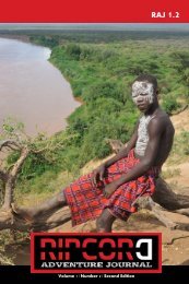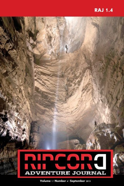
Ripcord Adventure Journal 1.4
After only four issues we appear to have been exiled voluntarily to beautiful Siberia, a region as vast as it is geographically diverse; from the pen of the first woman to cycle across the "new" Russia we travel the old stock route across Australia, from well to well and from story to story broadening our understanding of this island continent. The drive to explore, the reason to adventure is discussed before taking us underground to the vaulted caverns and flooded passages of the deepest cave system in the Americas to emerge suddenly back in to the full light of an Andean stratovolcano summit, the nearest point to space on earth that two companions can reach, until finally, the long road that this issue takes, brings us to the last place in Yemen. We aim to be the home of authentic, adventurous travel, which serves as a starting point for personal reflection, study and new journeys.
After only four issues we appear to have been exiled voluntarily to beautiful Siberia, a region as vast as it is geographically diverse; from the pen of the first woman to cycle across the "new" Russia we travel the old stock route across Australia, from well to well and from story to story broadening our understanding of this island continent. The drive to explore, the reason to adventure is discussed before taking us underground to the vaulted caverns and flooded passages of the deepest cave system in the Americas to emerge suddenly back in to the full light of an Andean stratovolcano summit, the nearest point to space on earth that two companions can reach, until finally, the long road that this issue takes, brings us to the last place in Yemen.
We aim to be the home of authentic, adventurous travel, which serves as a starting point for personal reflection, study and new journeys.

You also want an ePaper? Increase the reach of your titles
YUMPU automatically turns print PDFs into web optimized ePapers that Google loves.
Volume 1 | Number 4 | September 2015<br />
RAJ <strong>1.4</strong>
A Letter from the Editor<br />
Welcome to <strong>Ripcord</strong> <strong>Adventure</strong> <strong>Journal</strong>.<br />
After only four issues we appear to have been exiled voluntarily to<br />
beautiful Siberia, a region as vast as it is geographically diverse; from<br />
the pen of the first woman to cycle across the "new" Russia we<br />
travel the old stock route across Australia, from well to well and<br />
from story to story broadening our understanding of this island<br />
continent. The drive to explore, the reason to adventure is discussed<br />
before taking us underground to the vaulted caverns and flooded<br />
passages of the deepest cave system in the Americas to emerge<br />
suddenly back in to the full light of an Andean stratovolcano<br />
summit, the nearest point to space on earth that two companions<br />
can reach, until finally, the long road that this issue takes, brings us<br />
to the last place in Yemen.<br />
We aim to be the home of authentic, adventurous travel, which<br />
serves as a starting point for personal reflection, study and new<br />
journeys.<br />
On behalf of the editorial, writing and design team I wish to thank<br />
our sponsors Redpoint Resolutions (particularly Thomas<br />
Bochnowski, Ted Muhlner and Martha Marin), the World Explorers<br />
Bureau USA (Charlotte Baker-Weinert) and the team at<br />
<strong>Adventure</strong>.com for their continued support.<br />
Tim Lavery<br />
General Editor, <strong>Ripcord</strong> <strong>Adventure</strong> <strong>Journal</strong><br />
www.ripcordadventurejournal.com<br />
www.ripcordtravelprotection.com
<strong>Ripcord</strong> <strong>Adventure</strong> <strong>Journal</strong> © February 2015 by Redpoint<br />
Resolutions & World Explorers Bureau. All articles and images ©<br />
2015 of the respective Authors and photographers.<br />
All rights reserved. No part of this publication may be reproduced,<br />
distributed, or transmitted in any form or by any means, including<br />
photocopying, recording, or other electronic or mechanical<br />
methods, without the prior written permission of the publisher,<br />
except in the case of brief quotations embodied in critical reviews<br />
and certain other non-commercial uses permitted by copyright law.<br />
For permission requests, general enquiries or sponsorship<br />
opportunities, contact the publisher:<br />
<strong>Ripcord</strong> <strong>Adventure</strong> <strong>Journal</strong>: info@ripcordadventurejournal.com<br />
Supporting the following Organisation
"The memory of a cave I used to know at<br />
home was always in my mind, with its<br />
lofty passages, its silence and solitude, its<br />
shrouding gloom, its sepulchral echos, its<br />
flitting lights, and more than all, its<br />
sudden revelations of branching crevices<br />
and corridors where we least expected<br />
them."<br />
Mark Twain<br />
"Innocents Abroad"
RIPCORD<br />
ADVENTURE<br />
JOURNAL<br />
<strong>1.4</strong><br />
Editorial Team<br />
Shane Dallas<br />
Tim Lavery<br />
Ami Gigi Alexander<br />
Terry Sharrer<br />
Paul Devaney<br />
Featuring<br />
Sophie Ibbotson<br />
Max Lovell-Hoare<br />
Tor Torkildson<br />
Robb Saunders<br />
Kate Leeming<br />
Bill Steele<br />
John Lavery<br />
Jonathan Sterck<br />
Tim Mackintosh-<br />
Smith<br />
Publishers<br />
Redpoint Resolutions<br />
& World Explorers<br />
Bureau<br />
WWW.RIPCORDADVENTUREJOURNAL.COM
Contents<br />
Guest Editorial:<br />
The Long Road to <strong>Adventure</strong><br />
Robb Saunders<br />
Fifty years of continuous<br />
exploration<br />
Bill Steele<br />
Out there and back<br />
Kate Leeming<br />
50<br />
Jonathan Sterck<br />
Self Exile in Siberia<br />
Sophie Ibbotson & Max Lovell-<br />
Hoare<br />
The last place in Yemen<br />
Tim Mackintosh-Smith<br />
Book review: Mad, Bad &<br />
Dangerous to Know<br />
Book review: The Flying Carpet<br />
Contributors and credits<br />
1<br />
17<br />
35<br />
79<br />
93<br />
111<br />
131<br />
135<br />
139
The long road<br />
to adventure<br />
Robb Saunders<br />
1
2
AAAAAAAAAAAAAAAAAAAAAAAAAAAAAAAAAA<br />
AAAAAAAAAAAAAAAAAAAAAAAA<br />
11am, I was certain that I must have travelled well over ten<br />
kilometers since I left this morning. There could be no way that I<br />
had been walking for less than that. There was only one road to<br />
travel on for the next few days. Its gradient forever changing, like<br />
the sun trying its utmost to make itself known through the thick<br />
grey clouds that were sprinkling its watery remnants down upon<br />
me. Snow too had become more frequent as I made my way along<br />
the winding, lonesome road. I would stop occasionally to take<br />
photos of the vast, unpopulated landscape, and one or two selfies of<br />
myself to hopefully one day prove my adventurous nature to my<br />
future grandchildren. With the fast paced lives we currently live<br />
who knows if they will ever see such wonders as this.<br />
I was becoming concerned by this stage, the road was slowly<br />
becoming the only terrain for me to travel, and yet was also<br />
becoming the most dangerous. Bridges were more apparent the<br />
higher up the mountain I went, they supplied no space for<br />
pedestrians and thus forced me into the driving lanes. If cars, or<br />
worse, trucks were to appear whilst on these bridges I would have<br />
no place to move but hang myself over the railing and hope the<br />
residual force of the big metal vehicles wouldn’t thrust me off.<br />
It was then that I decided to try my luck at climbing down into the<br />
gully and crossing the river below. “How hard could it be?” I<br />
thought to myself whilst standing on the nice solid road. I stepped<br />
into the muddy grass and shrubbery laden wilderness, leaving the<br />
makings of civilization behind. Getting down needed to be carefully<br />
thought out, and slowly executed. One misstep or wrong grasp at a<br />
weak hanging tree branch and down the hill like Humpty Dumpty I<br />
will go. No one knowing I would be down there, most likely<br />
discovered first by the supposed brown bear I had been told about<br />
since arriving.<br />
Everything was wet and slippery. It smelt like moss and petrichor. I<br />
looked up and quickly realised that the bridge was now high up<br />
above me. A new feeling of terrified freedom that I have never<br />
known was both confronting and sensational. In that moment, no<br />
3
one on this enormous planet knew I was there. I could have held up<br />
there for weeks and never see a human soul, only to hear them echo<br />
over the bridge in the distance above. I was however on a schedule<br />
and needed to make ground quickly as this detour was eating time.<br />
When I came closer to the river I discovered something, I was stuck.<br />
In order to continue, I needed to get down to the river bed, the<br />
obstacle was manmade of vertical concrete. It resembled the walls of<br />
a dam. I contemplated jumping down but with my heavy 25kg pack<br />
it would either end badly for myself or worse, my precious<br />
expensive equipment, hence why I wasn’t going to drop my pack<br />
down first and try and climb freely. My best shot was a tree I<br />
spotted in the distance. I figured if I were to fall accurately toward<br />
the thickest part of the tree, leaving my feet firmly placed on the<br />
edge I would then be able to parkour style my way down using it as<br />
support against the concrete wall.<br />
AAAAAAAAAAAAAAAAAAAAAAAAAAAAAAAAAAAAA<br />
AAAAAAAAAAAAAAAAAAAAAAAAAAA<br />
At this point I could no longer tell if it was sweat or rain on my<br />
palms. Everything was wet and the sky was on the cusp of pouring.<br />
I stopped over analyzing my actions and leaned forward over the<br />
edge, arms out ready for impact. What was I doing here!<br />
The auction of my apartment didn’t go well, a handful of potential<br />
buyers and not one made an offer. I wanted to scream I was so<br />
frustrated. The planning was complete, everything was mapped out,<br />
and all I needed was the funds to put it into fruition. The funds I<br />
had hoped to receive from the sale, the sale that had been promised<br />
to me by the real estate agent, who was losing his credibility by the<br />
day.<br />
My body was still stuck in Australia, my mind was already trekking<br />
the vast landscapes of an unknown world. I had made it, my first<br />
time traveling alone, my first proper adventure! I could dictate<br />
everything I wanted to do, and what I wanted to do was walk. My<br />
goal was to land at the top and walk for three months down this<br />
ancient landscape.<br />
I landed on the 17th of May. It was wintery cold and the air was<br />
4
5
AAAAAAAAAAAAAAAAAAAAAAAAAAAAAAAAAAAAA<br />
AAAAAAAAAAAAAAAAAAAAAAAAAAA<br />
filled by a thick fog. I decided I would spend the weekend<br />
composing myself before beginning my trek. One, to let everything<br />
sink in, and two, to spend some time exploring the strangely<br />
familiar but somewhat different city that I was in. So when I arrived<br />
at the hotel I decided that instead of recuperating in my room I<br />
would throw my bags down and head out. To which I discovered<br />
that the main social hub nearest me was the train station. Over time<br />
it dawned on me that having a shopping and restaurant district<br />
intertwined with the railway system was a common occurrence and<br />
it surprises me that they have not quite picked up on that logical<br />
enterprise back home. I walked around the restaurant district for<br />
somewhere to eat and came upon an Irish pub. Mainly out of a<br />
traveler’s curiosity to see how they portrayed it, I went in and<br />
ordered a pint and sat at the bar. The smell of tobacco infused with<br />
cooked meat and stale beer consumed the air. It was dark and had<br />
the feel of an old establishment even though it was inside a shopping<br />
mall and could not have been older than ten years. I heard many<br />
English speaking westerners in the bar. As I had just arrived I had<br />
no desire to socialize with them. I was also content with being alone<br />
with my thoughts.<br />
A little while later the barman approached to inform me that I was<br />
invited to sit with a group at the nearby table. I turned to see they<br />
were all women, around my age, enjoying after work refreshments<br />
and snacks. They waived me over so I kindly obliged.<br />
“Hello.” I said trying to enunciate as clearly as possible.<br />
“Hello.” They replied gleefully and as cautiously as possible to not<br />
embarrass themselves with the foreign tongue.<br />
I pulled up a chair and sat down. I can only recall one name of the<br />
women. Seiko, she was strongest at English so she was most curious<br />
to know my intentions about why I was in her homeland. To which<br />
I began explaining that I had just arrived this evening and about to<br />
embark on a three month journey walking south. Once Seiko<br />
relayed what I said back to her friends they seemed confused, they<br />
6
could not understand the purpose of such a trip. “Why not take a<br />
train, a bus, a car or fly to the destinations you want to see?” What<br />
they didn’t understand and I guess myself at the time was that I had<br />
not really thought about where I was going to go, the adventure<br />
itself was the destination.<br />
The impact was hard, but my hands stayed true, my arms however<br />
underestimated the added weight and almost failed me. I shimmied<br />
down and was back on solid ground. The rain was well and truly<br />
making its presence known but being wet was not a concern I<br />
carried with me. I traversed the river’s edge looking for a safe and<br />
shallow way across. There was a line of tall rocks about ankle deep<br />
that were situated the full length across. I was happy to be able to<br />
put my new waterproof hiking boots through some proper tests<br />
during this challenging event. I stepped onto the first rock. The<br />
water was moving a lot quicker than anticipated but nothing to<br />
worry myself over. I moved to the next rock. Success! I managed to<br />
frolic my way across rock to rock like a gazelle, I was becoming so<br />
proficient that my socks were not yet wet, which, as is Murphy’s<br />
Law, due to my overconfidence I forgot a key point. It is said that a<br />
rolling stone gathers no moss. So what do stones that don’t move<br />
do? It was the last rock, which was above the surface of the water, I<br />
hopped, skipped and slipped on its mossy face and submerged my<br />
legs into the water. My perfect game was ruined, it had happened,<br />
the socks were wet!<br />
AAAAAAAAAAAAAAAAAAAAAAAAAAAAAAAAAA<br />
AAAAAAAAAAAAAAAAAAAAAAAA<br />
I pulled myself into the river bank and began climbing my way back<br />
up to the road. I was now on the other side of the bridge. I decided<br />
after that time consuming endeavor that I would risk it on the next<br />
bridge and try and make a run for it, but first, I needed to a new pair<br />
of socks!<br />
From where I lay, on a hard, sterile and cold bed in the emergency<br />
department of the Epworth hospital in Melbourne, Australia, my<br />
outlook didn’t look promising. Everything could be over before it<br />
began. Unable to sit up, unable to move at all without my spine<br />
feeling like it was trying to rip itself out of my body, I lay there, the<br />
7
AAAAAAAAAAAAAAAAAAAAAAAAAAAAAAAAAAAAA<br />
AAAAAAAAAAAAAAAAAAAAAAAAAAA<br />
hospital curtain closed but never enough to give me the privacy I<br />
needed to quietly sob. In only a few months I was supposed to be<br />
on an adventure, now it may not happen.<br />
I had damaged my back that evening. Twenty minutes into starting<br />
my shift at work. A task I undertake every day, a task that I had<br />
mentioned many times to my superiors that it is hazardous to do<br />
alone. You would think something as simple as moving a table<br />
wouldn’t be difficult, but these are crafted from a thick glass with<br />
long, solid timber legs. This particular day I moved it and the dam<br />
leg broke! I instinctively thrust down to catch it before the glass<br />
broke on the floor, good thing was I caught the glass; the only thing<br />
that broke was me. I was stuck in a dark, moldy and humid concrete<br />
store room for twenty minutes before I was discovered, placed into<br />
a wheelchair and driven to the hospital. In the past I guess we have<br />
all wished for a small minor injury to get us out of work. This was<br />
not one of those days.<br />
The doctor came back in. Gave me some strong painkillers and<br />
orders to go home and rest for a couple of weeks and check in with<br />
my doctor. I asked about how it would affect my travel plans...<br />
It was not good news.<br />
I decided that camping may not be as fun as everyone makes it out<br />
to be. Can you still be an adventurer and not like camping? I woke<br />
up, saturated by the watery dew from the inside of the tent, it must<br />
have dropped to below 5 degrees Celsius overnight. I had put my<br />
thermal undergarments and all my other items of clothing on during<br />
the night to stay warm. I even put my rain jacket on in the hopes of<br />
staying dry, but the cold weather and the humidity from my body<br />
heat was causing some extreme indoor climate issues. The sleep I<br />
had was more broken than I anticipated but I hadn’t been killed by<br />
the strange noises outside my tent, so that was a plus. I could not<br />
tell if the sun had risen or if that was just a streetlight shining<br />
through, the sound of children became more apparent the longer I<br />
lingered so it must have been morning. How late in the morning<br />
8
9
10
was answered once I stepped out of the tent and discovered the<br />
grass I had made camp in last night was actually a baseball field, and<br />
it was game day. Great!<br />
Ten days had gone by. My back was straining at every physical<br />
movement but bearable to walk slowly around the house. The pain<br />
didn’t want to leave so eagerly like I had hoped. Maybe I’ve<br />
overestimating myself. By this stage the stabbing sensations were<br />
hurting my sense of adventure more than my body. “I should be at<br />
work, I should be planning my trip now!” I had an abundance of<br />
time at home to plan for the trip, but all I achieved was binge<br />
watching episodes of Game of Thrones, The Walking Dead and<br />
eating too much delicious ice cream. My motivational jar was as<br />
empty as a tip jar at a bank.<br />
AAAAAAAAAAAAAAAAAAAAAAAAAAAAAAAAAA<br />
AAAAAAAAAAAAAAAAAAAAAAAA<br />
The trip was over before it begun.<br />
My damn back! Three weeks into my walk and it was all starting to<br />
trouble me once more. I had some painkillers in my first aid kit with<br />
the hopes that I would not need them, or at the very least not for<br />
my back, I had to power through, I trekked close to forty<br />
kilometers the previous day, back pain will not defeat me!<br />
Camping in a baseball field for the night wasn’t exactly comfortable<br />
so the fatigue was setting in. I had walked almost eighteen<br />
kilometers this morning from where I departed in front of the<br />
shocked parents and utterly intrigued and excited young baseball<br />
players. I was only planning on averaging that distance a day, but<br />
my destination was eighty kilometers away, and I needed to get<br />
there in 48 hours.<br />
Having passed the mountainous terrain and with winter now<br />
winding to a close the sun was taking advantage. I was becoming<br />
tiresome and hot. I had changed my socks once already and<br />
bandaged up my blistered feet. I was walking along the coast now<br />
and the smell of the ocean reminded me of home. Sitting on the<br />
beach in Australia and digging trenches in the sand for the water to<br />
11
AAAAAAAAAAAAAAAAAAAAAAAAAAAAAAAAAAAAA<br />
AAAAAAAAAAAAAAAAAAAAAAAAAAA<br />
travel through. Yes I’m an adult. The sand on this beach however<br />
didn’t feel like home. It felt more solid, like it had been mixed with<br />
clay. The colour was also a dark brown instead of a breezy yellow.<br />
The good thing was it definitely made walking easier, and when a<br />
gust of wind came along the sand wouldn’t give in and fly up to<br />
attack my eyes like microscopic Hulks. I was making ground<br />
quickly and forgot myself, due to getting lost in the moment I lost<br />
the road I was following, which was no longer in sight.<br />
The human body is a strange and wonderful machine. One minute<br />
you are struggling with body movement and the next its back up to<br />
being fully functional. In my case I was back to training, walking<br />
the two hour stroll home from work every day, only minor soreness<br />
along the way. The light at the end of the tunnel was becoming<br />
much larger. All I needed to accomplish now was finding the money<br />
to make it through.<br />
Bang! Smash!<br />
The sound that shot me out of the hotel bed and onto my shaking<br />
feet. Disorientated, for a second I thought I was still back home in<br />
my old room, in the apartment I had once owned, the apartment I<br />
sold to be right here, experiencing this terrifying stuff.<br />
Crack! Kick!<br />
I knew dipping into my budget to splurge a little extra cash for a<br />
hotel room with a fluffy double bed would come back to haunt me,<br />
I didn’t think it would be literal. A shadowy figure was peering<br />
under my door from the hotel hallway. Constantly turning the<br />
locked door handle whilst banging the wood. I stood, frozen in fear<br />
and confusion. I thought to myself, “I have worked for hotels for<br />
almost ten years, I have witnessed many strange things during my<br />
time, and I’ve even had to break into rooms on many occasions”.<br />
Which made me realize, this isn’t an employee, this is someone<br />
trying to get into my room, maybe to me, maybe he wants my<br />
camera, my laptop, my ice cream! In those small minute seconds<br />
12
that I was frozen, all kinds of terrible thoughts entered my mind. I<br />
grabbed my pocket knife from the desk and walked over to the<br />
door. A few more minutes and this person will be inside. In a tone<br />
of voice so deep it could have been mistaken for James Earl Jones<br />
these words sprayed out of my mouth…<br />
“HEY! GET LOST!”<br />
The shadow was motionless, some silent phrases were said that were<br />
too soft, and also not English for my ears to decipher. The silence<br />
became more terrifying than the banging, I was paralyzed once<br />
more. It felt as though we were staring at one another through the<br />
solid wooden door. Both motionless, like a game of chicken,<br />
whoever moved first would lose and the victor would get the<br />
comfort of the soft warm bed, and my ice cream. As I was awoken<br />
in the middle of a REM cycle my mind was contemplating all<br />
possibilities, be it the logical reality or the supernatural. What felt<br />
like an eternity went by and still no movement, soon frustration was<br />
beginning to push my fears aside and prepare myself for<br />
confrontation. I wanted to go to bed, I wanted to sleep, this time I<br />
needed some Clint Eastwood style vocals.<br />
AAAAAAAAAAAAAAAAAAAAAAAAAAAAAAAAAA<br />
AAAAAAAAAAAAAAAAAAAAAAAA<br />
“Hey, get out of here asshole!” I said sternly.<br />
I walked over to the door and began to make door handle noises. I<br />
knew if that didn’t work the next move would be to open the door<br />
and hope this person was smaller than me, didn’t have a weapon,<br />
and didn’t know karate.<br />
The shadow disappeared from under the door. I heard the sounds of<br />
footsteps fading in the distance. With my frustration now pounding<br />
on my ego to go do something about this disturbance, I opened the<br />
door. The hallway was so brightly lit it took a moment for my eyes<br />
to adjust. I began to walk towards the elevators where my disturber<br />
would be waiting when suddenly I realized something. I’m hardly<br />
clothed, and my hotel key was sitting smugly on the cabinet in my<br />
room laughing to itself at my stupidity. I hadn’t heard the door close<br />
13
AAAAAAAAAAAAAAAAAAAAAAAAAAAAAAAAAAAAA<br />
AAAAAAAAAAAAAAAAAAAAAAAAAAA<br />
yet, I ran back to my room at top speed. I could see the gap closing<br />
between two universes, one with me in my warm, sleep filled<br />
solitude and the other of me, explaining my embarrassment barely<br />
clothed to the front desk attendant.<br />
April 2014, after over six months on the market, my apartment was<br />
finally sold. It was my ticket out. My Walter Mitty moment. Over<br />
the next month I quit my job, collected my travel gear and said<br />
farewells to my loved ones. It was time.<br />
Time for me to disappear.<br />
To a distant land over the seas.<br />
To a land that thrives on respect and honor. A civilization centuries<br />
old before my country had even been discovered by the British.<br />
To a land where tradition meets innovation.<br />
To the land of the rising sun.<br />
Japan.<br />
Having spent three months in this wonderful country, my time here<br />
was near its end. The experience will not leave me any time soon<br />
and I will be forever grateful to the people I met and who helped me<br />
along the way.<br />
Like the kind man at the convenient store who saw me sitting<br />
outside during one of my many breaks, who had taken it upon<br />
himself to come outside and bring me a cold bottle of sparkling<br />
water, asking nothing in return but a smile.<br />
To the women working at a petrol station who saw me walking late<br />
one afternoon, noticeably tired. They asked me where I was going<br />
to which I replied I was looking for a hotel nearby. They asked me<br />
to wait, they brought me some water and ten minutes later a taxi<br />
14
arrived for me. Perplexed I looked around to see the women smiling<br />
and waving.<br />
To the two fish mongers in the early days of my journey, my body<br />
still was adjusting to the food, which introduced an issue that<br />
requires immediate attention in the form of a restroom. As I walked<br />
into your shop I fell, to which you both helped me to my feet<br />
without hesitation as to why a strange man was entering. When<br />
discovering of my predicament you invited me into your home in<br />
the back, introduced me to your family and let me use your private<br />
bathroom, no questions asked. Upon leaving you would not accept<br />
what little currency I had on me at the time, you gave me a cold<br />
drink and sent me on my way.<br />
When looking back on my adventure in Japan, from Sapporo to<br />
Osaka, it won’t be the landmarks, the tourist attractions or the<br />
landscape that will bring a smile to my face. It will be small<br />
moments such as these that I will cherish with fond memories.<br />
15
"As soon as you have crossed your doorstep<br />
or the county line, into that place where<br />
the structures, laws, and conventions of<br />
your upbringing no longer apply, where<br />
the support and approval (but also the<br />
disapproval and repression) of your family<br />
and neighbors are not to be had: then you<br />
have entered into adventure, a place of<br />
sorrow, marvels, and regret."<br />
Michael Chabon<br />
"Gentlemen of the Road"<br />
16
50 years of<br />
continuous<br />
exploration:<br />
Sistema Huautla, the<br />
Deepest Cave in the<br />
Americas<br />
Bill Steele<br />
8<br />
17
18
In the summer of 1965 three young Texas weekend spelunkers<br />
drove a low riding car up a newly constructed dirt road in the Sierra<br />
Mazateca of the northern part of the southern Mexico state of<br />
Oaxaca. They were seeking caves with the potential to be the<br />
deepest in the Americas. They had it right. As soon as they got in<br />
the vicinity of Huautla de Jimenez, they started finding cave<br />
entrances.<br />
The next year they returned with ropes and drove to the other side<br />
of the mountain town of Huautla. Immediately they found two<br />
large cave entrances in the bottom of deep sinkholes. These are the<br />
primary entrances of Sistema Huautla, a mega cave system with 20<br />
entrances, 7<strong>1.4</strong> km (44 miles) in length, 1,554 m (5,097 feet) in<br />
depth, making it the deepest known cave in the Western<br />
Hemisphere, the 8th deepest cave in the world, the longest of the 16<br />
deepest caves in the world, and what many cavers feel is the greatest<br />
cave on Earth.<br />
AAAAAAAAAAAAAAAAAAAAAAAAAAAAAAAAAA<br />
AAAAAAAAAAAAAAAAAAAAAAAA<br />
Fifty years later, over thirty expeditions, seven of them Explorers<br />
Club flag expeditions, these exploration of these caves has renewed<br />
momentum. Late March to early May 2015 forty-seven speleologists<br />
from seven countries: USA, Mexico, Great Britain, Australia,<br />
Poland, Switzerland, and Romania participated in a six week<br />
expedition in varying lengths of stay. There was a long list of<br />
objectives, including exploring unexplored passages by “checking<br />
out leads” indicated in past underground survey field notes.<br />
The restarted project exploring and studying the caves of the<br />
Huautla de Jimenez, Oaxaca, Mexico has been given the name of<br />
Proyecto Espeleologico Sistema Huautla (Huautla system<br />
speleological project), or PESH for short. PESH was launched in<br />
2013 with the objectives of extending the mapped length of the cave<br />
system from the then 65 km to over 100 km, the depth from the<br />
current 1,554 m to 1,610 m (a vertical mile, or 5,280 feet), and all the<br />
while maintaining “full speleology”, meaning studies and papers<br />
written on the various study disciplines of speleology: geology,<br />
hydrology, biology, paleontology, archaeology, and exploration<br />
19
techniques.<br />
AAAAAAAAAAAAAAAAAAAAAAAAAAAAAAAAAAAAA<br />
AAAAAAAAAAAAAAAAAAAAAAAAAAA<br />
The exploration of the Huautla caves has gone through phases. The<br />
years 1965-1970 saw several expeditions organized by cavers from<br />
the USA and Canada, and the establishment of the cave Sotano de<br />
San Agustin as the deepest cave in the Americas at 600 m in depth. It<br />
was felt that the cave was fully explored.<br />
In 1976 a group went to see this cave and check out a “lead”<br />
indicated on the map published by the Canadians a few years<br />
before. In caving jargon a “lead” is a possible unexplored passage. A<br />
lead is indicated on a cave map with broken continuing lines and a<br />
question mark. Maybe it goes on, and maybe it doesn’t. The reason<br />
the lead had not been entered eight years before was that it was very<br />
remote, taking two days of underground travel to get to it, and there<br />
was a very difficult overhung climb about five meters high. This<br />
climb was successfully climbed, a passage did indeed continue, and<br />
since then the cave has been explored from a length of two miles<br />
then to 44 miles now and the depth is two and a half times deeper.<br />
After the 1976 expedition there was one expedition after another<br />
most years until 1994. The 1994 expedition was a major three<br />
month-long effort that resulted a book being written about it,<br />
“Beyond the Deep”. The farthest the 1994 expedition reached was a<br />
deep pool of water at a depth of 1,475 m below the highest point<br />
reached in the cave system. The pool was extremely remote and<br />
required not only hundreds of meters of technical rope work, but<br />
long dives underwater too, with rebreathers and sophisticated scuba<br />
gear, and camping in the cave beyond the reach of any means of<br />
communication with the surface.<br />
Between 1994 and 2007 there were a few scattered expeditions to the<br />
Huautla caves, but several of those years saw no activity. The<br />
Huautla cavers were exploring caves elsewhere in Mexico, USA,<br />
China, Puerto Rico, etc.<br />
Then came 2013 and the big British-led expedition. Young, very<br />
20
active, British cave explorers sought logistical information from me<br />
and others to mount their own expedition to dive in the deep pool,<br />
called a “sump” in caver parlance, at the bottom of the cave.<br />
Through the years leading up to this expedition Sistema Huautla<br />
had been surpassed in depth by a cave not far south of it, on a high<br />
mountain range separated from the Huautla plateau by a deep<br />
canyon, and this cave, Sistema Cheve, had a surveyed depth only<br />
nine meters deeper than Sistema Huautla.<br />
AAAAAAAAAAAAAAAAAAAAAAAAAAAAAAAAAA<br />
AAAAAAAAAAAAAAAAAAAAAAAA<br />
The Brits had a successful expedition and explored 80 m deep in the<br />
pool of water, using mixed gases for breathing. Eighty meters was<br />
the limit what they could do with the gases they were breathing so<br />
they ended the dive there, with the water-filled passage descending<br />
at least another 20 meters they could see with powerful underwater<br />
dive lights. Sistema Huautla was once again the deepest cave in the<br />
Western Hemisphere at 1,554 m from the highest point humanly<br />
reached in the cave, to the lowest point humanly reached. That’s the<br />
way it’s figured in a deep cave.<br />
Tommy Shifflett from Virginia and I joined the British expedition<br />
for the last part of it. We had our own<br />
area to look at, looking for unexplored passages, and found over<br />
half a kilometer of lovely decorated, unexplored passages after<br />
doing an aid climb across the top of a shaft.<br />
Tommy and I talked while we were there together about how much<br />
we love the caves and the area of Huautla, Oaxaca, and there is<br />
much remaining to do. So in the airport in Oaxaca, as we waited for<br />
our respective flights back to the USA, we sketched out a plan for a<br />
restart of annual expeditions to Sistema Huautla and other caves of<br />
the area.<br />
We decided to give our project a new name – in Spanish this time –<br />
Proyecto Espeleologico Sistema Huautla, and wrote down our<br />
goals:<br />
- To explore, survey, and conduct a comprehensive speleological<br />
21
AAAAAAAAAAAAAAAAAAAAAAAAAAAAAAAAAAAA<br />
AAAAAAAAAAAAAAAAAAAAAAAAAA<br />
study of the Sistema Huautla area caves.<br />
- Conduct speleological studies to include exploration and mapping,<br />
cartography, geology, hydrology, biology, paleontology,<br />
archaeology, and equipment and technique development.<br />
- Support Mexican cave scientists in field research.<br />
- Conduct annual springtime expeditions for ten years 2014-2023.<br />
- Survey data kept current.<br />
- Goal of reaching 100 km in length.<br />
- Goal of reaching 1,610 m in depth, which is 5,280 ft., a vertical<br />
mile.<br />
- All results published.<br />
All of this is easy to say, but to say we’re going to have annual<br />
expeditions for ten years, it’s very important that the first one be<br />
successful. The first PESH expedition, in 2014, was successful on<br />
several fronts. Diplomacy at the state, municipio, and agencia levels<br />
was for the most part fruitful, with permission granted to go caving<br />
in the area for three years. One area remains a challenge due to the<br />
resident Mazatec people’s beliefs in cave spirits and what might<br />
happen if they are angered by foreigners going in caves no one has<br />
ever entered. A plan has been formulated to do diplomatic work to<br />
deal with this issue, but it’s going to take several years to overcome,<br />
if it’s ever overcome.<br />
The area to the east of the known passages of Sistema Huautla, was<br />
an objective, to search for new cave entrances that might descend<br />
deep and connect with the cave system below. Around 20 new pits<br />
and caves were explored and mapped, without anything going very<br />
far or deep. A cave southeast of known passages in the system<br />
shows promise with strong airflow and the exploration of it will<br />
continue during the 2016 expedition.<br />
Oscar Franke, Ph.D., professor of biology, a noted arachnologist<br />
and scorpion expert and a professor at the National Autonomous<br />
University of Mexico (UNAM) in Mexico City, joined our<br />
expeditions in 2014 and 2015 and brought along three graduate<br />
students each time. They are thrilled that they have collected twelve<br />
22
new species of cave life, including new species of tarantula, new<br />
species of harvestmen spiders, and a new species of scorpion in the<br />
caves. They will return in 2016.<br />
An important paleontological site was found in a cave as well. In a<br />
series of large adjoining rooms in a cave we had not visited in over<br />
30 years, not far from the village where we rent houses, large bones<br />
were noticed in a talus cone of dirt on the floor. We think there must<br />
have been an entrance above the bones at one time in the distant<br />
past. Based on photographs taken with scale and sent to a<br />
professional paleontologist in Mexico City, he feels that at least one<br />
of the animals is an extinct Pleistocene ground sloth. A graduate<br />
student of his joined us for a week this year and plans to return for a<br />
longer amount of time in 2016 to excavated the 1 ½ m tall cone of<br />
bones and other ancient surface debris.<br />
Halfway through the first PESH expedition in 2014, five cavers<br />
arrived with packs already prepared to go underground and camp in<br />
the La Grieta section of Sistema Huautla. La Grieta, meaning “the<br />
crack”, is a significant section of Sistema Huautla. It’s over 700 m in<br />
depth to where it connects to the system and has tributaries feeding<br />
into it that were initially explored in 1977, but no one had been back<br />
to them since then.<br />
Taking underground backpacks, five cavers went into La Grieta to<br />
stay underground for nine days. They set up a remote camp and<br />
explored an upstream tributary initially explored without finding an<br />
end in 1977. They succeeded in discovering and mapping 1.6 km of<br />
new passages. This was Kasia Biernacka of Poland, Gilly Elor,<br />
Corey Hackley, John Harman, and Bill Stone of the USA. Three of<br />
them camped underground for seven days and two of them for nine.<br />
Their most significant discovery was a passage extending over 1.5<br />
km to the north, directly toward the highest topography in the area.<br />
They turned around in 20 X 20 m borehole passage because they<br />
were running low on food and battery power for their lights. This<br />
continuing passage is a major objective for 2016.<br />
23
AAAAAAAAAAAAAAAAAAAAAAAAAAAAAAAAAAAAA<br />
AAAAAAAAAAAAAAAAAAAAAAAAAAA<br />
The second annual PESH expedition took place from March 23 –<br />
May 5, 2015 with 47 speleologists and support people from ten<br />
counties; the United States, Mexico, England, France, Germany,<br />
Poland, Switzerland, Austria, Romania, and Australia.<br />
Cavers explored the upstream sump (a sump is a cave passage with<br />
water to the ceiling (necessitating scuba gear) in Red Ball Canyon at<br />
the 700 m (2,296 foot) deep Sotano de San Agustin section of<br />
Sistema Huautla, an area not seen since 1979. On the far side of<br />
three sumps, 30 m, 30 m, and 5 m long, two cavers, Andreas<br />
Klocker of Australia, and Zeb Lilly of Virginia in the USA, direct<br />
aid climbed 180 m (590 feet) vertically beyond it. It continues to go<br />
up into the unknown and is getting bigger.<br />
They also discovered a new and potentially extensive new part of<br />
the La Grieta section of Sistema Huautla. Dubbed Mexiguilla due to<br />
its similarity with New Mexico’s (USA) Lechuguilla Cave (one of<br />
the world’s most beautiful caves), the area has the best formations<br />
yet found in the 44 mile long cave system.<br />
Besides Sistema Huautla, teams explored and mapped small caves in<br />
the area in hopes of opening up new sections of Sistema Huautla.<br />
Progress was also made with public relations efforts to gain access<br />
to unexplored entrances where local Mazatec Indians believe cave<br />
spirits reside and fear offending them, resulting in their corn not<br />
growing well or their children getting sick. At the suggestion of a<br />
local government official, PESH designed, created, and installed a<br />
USA National Park visitors’ center quality display in the local<br />
government building, with 16 excellent photographs as large prints<br />
informative text in Spanish, and a profile map with scale of the cave<br />
showing it to be as deep at four Empire State Buildings in New<br />
York City stacked on top of each other.<br />
Another focus of the 2015 expedition was underground<br />
photography. Six excellent cave photographers were part of the<br />
team: Karis Biernacka of Poland, Liz Rogers of Australia, Dave<br />
Bunnell, Steve Eginoire, Chris Higgins, and Matt Tomlinson of the<br />
24
25
26
USA. A coffee table book of the best Huautla cave photographs<br />
through the years is being planned for the future.<br />
PESH 2016 Expedition<br />
Planning and preparing for our next expedition is underway in early<br />
September 2015. The dates are set: basically the month of April with<br />
a week of preparation in the field prior to that. Preparation in the<br />
field includes three days of driving from Texas to southern Mexico,<br />
visiting local government officials and getting permits and<br />
permissions, renting houses in a small village near the entrance to<br />
the section of the cave system we will concentrate on, and setting<br />
the houses up, which means getting the kitchen operating, buying<br />
groceries, and preparing for twenty more people to arrive in a few<br />
days. Then it will be four weeks of high energy activity with<br />
unexpected and usually surprising news reports from underground<br />
explorations.<br />
AAAAAAAAAAAAAAAAAAAAAAAAAAAAAAAAAA<br />
AAAAAAAAAAAAAAAAAAAAAAAA<br />
We have a long list of exploration and study objectives for the next<br />
expedition, but then there is the possibility of the unexpected<br />
happening. The unexpected happened on the first two PESH<br />
expeditions, and they both happened late in the expeditions. “The<br />
unexpected” is something almost unique to cave exploration in these<br />
modern times. Since satellite photos are not available because caves<br />
are beneath the earth’s surface, and no technology exists that can<br />
penetrate thick layers of rock in mountains to see where cave<br />
passage lie, you literally don’t know until you go, in other words,<br />
pure exploration is still possible on Earth. The unexpected in cave<br />
exploration is usually when a surprising discovery is made where<br />
the geology of the cave as it is understood did not hold true and<br />
there is an unusual variation in the geologic structure.<br />
Near the end of the 2014 expedition, on the last day of a seven day<br />
stay deep in the cave, explorers working from a remote camp, 400 m<br />
below the surface, broke out into a 20 meter diameter tunnel<br />
bearing due north. It’s probably been there for five million years,<br />
but no one had ever reached it before. As much as it pained the team<br />
27
AAAAAAAAAAAAAAAAAAAAAAAAAAAAAAAAAAAAA<br />
AAAAAAAAAAAAAAAAAAAAAAAAAAA<br />
of five that found it, after exploring ahead a few hundred meters and<br />
mapping it, they took a photo to show its grandness and turned<br />
around to head out. That continuing passage is the number one<br />
objective in 2016. A team of five is already making plans to remain<br />
deep underground for one month and explore that passage as far as<br />
they can.<br />
Two other main objectives are in the same cave and will require<br />
other teams to camp deep and far in the cave to explore them. One<br />
was discovered late in the 2015 expedition. Three cavers had gone<br />
deep into the cave to “winterize it”, meaning pull ropes up shafts as<br />
they exited the cave, and leave the ropes coiled there where flood<br />
waters in the coming rainy season would not wash them away or<br />
damage them.<br />
Their plan was to camp one night in the remote underground camp,<br />
using sleeping bags and stoves already staged there for use in 2015,<br />
and the next day climb out of the cave and pull the fixed ropes up as<br />
they did. The problem was that one of them got sick once they got<br />
to the camp. He was going to need a day to recuperate, so the other<br />
two decided to do some exploring and mapping. They looked at the<br />
survey notes from the year before and picked a minor “lead”, a side<br />
passage noted but not yet explored, and decided it was close enough<br />
to the camp where the sick caver would be left, and they would give<br />
it a few hours and probably finish it.<br />
That’s not what happened. As soon as these two got on their hands<br />
and knees in soft sand in the low passage, they felt a strong breeze<br />
and smiled at each other. Cavers know, “if it blows, it goes.”<br />
Barometric exchanges with the changing air pressure on the surface<br />
cause breezes, sometimes even strong winds in caves, and cavers get<br />
good at detecting these clues and following them.<br />
And follow the wind these two did, to a new section with the most<br />
beautifully decorated passages found in all of the caves in Huautla.<br />
These two explorers, Gilly Elor and Derek Bristol, marveled at the<br />
wonderment of perhaps one of the most beautiful places on earth,<br />
28
or rather inside earth. Derek has done a fair amount of exploring in<br />
Lechuguilla Cave, New Mexico, said by many to be the most<br />
beautiful cave known. He thinks the section of Sistema Huautla<br />
they found that day in late April 2015, is as good. So, in thinking<br />
hard for a name for it, he coined the name Mexiguilla, combining<br />
the words Mexico and Lechuguilla. Mexiguilla will be explored,<br />
mapped, and photographed in 2016.<br />
Another top objective for 2016 is in this same section of Sistema<br />
Huautla. It’s over 700 m deep. Seen only once in 1977, there is a<br />
gigantic dome with a waterfall named Doo Dah Dome. It’s as wide<br />
and soaring as the dome of St. Peter’s Basilica, but much taller. The<br />
passage followed to get to it is named the Wind Tunnel, there is so<br />
much wind blowing through it. Doo Dah Dome is of unknown<br />
height. The lights of today are so much better than they were in<br />
1977, so perhaps in 2016 explorers will be able to see the top of the<br />
dome. But then again, maybe not. The plan is to climb it, using<br />
direct aid, and explore up-trending passages toward the surface,<br />
possibly as much as 1,000 m (3,300 feet) above.<br />
Gear and techniques<br />
A lot has changed gear-wise in the 50 years the caves of Huautla<br />
have been explored. In 1965 the first cavers wore denim pants and<br />
jackets and work boots. Their helmets were construction hard hats<br />
and their headlamps were carbide lights. Every three to five hours<br />
they had to refuel their carbide lamps. If they got wet, and the<br />
Huautla caves are wet even in the driest time of the year, their<br />
cotton pants and jackets sapped their body heat.<br />
Cavers not shun cotton completely. Synthetic materials make<br />
underwear warm even when wet. For outerwear nylon or PVC<br />
coveralls are worn. These are very durable and protect the caver<br />
from the often sharp walls. For boots most cavers wear lugged<br />
rubber canyoneering boots. Wet caves soften leather and leather<br />
boots die off quickly.<br />
29
A couple of years ago I wrote an article and got it published in a<br />
cavers’ journal titled “The Light is the Future is Here Now”. In it I<br />
recalled being miles from the entrance, deep in a cave, as a teenager,<br />
taking a break, waiting for someone to refuel his carbide lamp<br />
before it was my turn, and discussing how someday, someday way<br />
off the distant future, we will have very rugged headlamps with<br />
different settings to switch from 180 degrees of full periphery light<br />
to a beam that could reach the bottom of a deep, perhaps 500 foot<br />
deep shaft, to see if the rope we had just rigged reaches the bottom.<br />
It will be totally waterproof with batteries that last so long you can<br />
go on a long, maybe even 20 hour, non-stop caving trip and not<br />
have to change batteries. We laughed and someone said, “Like I’ll<br />
live long enough to see that!” I hope that he has. I have.<br />
I have a top of the line Scurion headlamp. Its Swiss engineered and<br />
made, very futuristic-looking, and does all of those things. Your<br />
headlamp is your primary piece of gear in caving. If you are out of<br />
light, you are stuck or you are borrowing a light. My Scurion is just<br />
one of four lights I always have with me in a cave. More often than<br />
not I have loaned a light to someone before I needed a backup light.<br />
The Scurion has never failed me.<br />
The ropes the first Huautla cavers had in the 60s were of a laid<br />
construction, meaning three strands twisted very tightly together, a<br />
rope named Goldline, which was known and dreaded for spinning<br />
anytime a caver could not stop the spinning by reaching out to the<br />
wall. If the rope hung in free space, a caver would spin round and<br />
round. Sometimes they got motion sick from the spinning.<br />
Packs were army surplus made of canvas. Canteens were also army<br />
surplus, or sometimes left over from when the caver was a Boy<br />
Scout.<br />
All the early Huautla cavers were male. That was in the 60s. In the<br />
70s it changed and about a fourth were female. Now it sometimes<br />
approaches 50%. This is a very welcome development.<br />
30
31
32
The ropes also changed in the 70s from the laid, twisted<br />
construction of Goldline rope, to the kernmantle, braided design of<br />
modern caving ropes, which don’t spin in free fall and don’t stretch.<br />
They are also very tough and abrasion resistant.<br />
Over the past twenty years the European technique of rigging<br />
rebelays, deviations, and using smaller, 9mm ropes has been adopted<br />
in Mexico and in much of the USA. Rebelays are when a rope is<br />
anchored on the wall of a shaft so that the rope does not make<br />
contact with a sharp place on the wall. A deviation is when a sling or<br />
a runner is used so the rope passes through a carabiner and is held<br />
away from the wall or sharp edge.<br />
Rappelling devices are exclusively either a rappel rack, or a bobbintype<br />
rappelling device, usually a Petzl Stop or Simple. The latter<br />
type is quicker when passing a rebelay and it has to be taken off the<br />
rappel rope in mid-shaft.<br />
Rope ascent is done by a technique called frogging. It’s a sit/stand<br />
technique, where a Petzl Croll ascending device is attached to a low<br />
slung seat harness and lifted by a chest harness when a climbing<br />
caver stands. Once seated they kick their heels back under their<br />
fanny, slide up an upper mechanical ascender which has a loop for<br />
their feet, and then stand up and do it again, moving like an<br />
inchworm. Once learned, it’s quite efficient, and since you are<br />
standing with both legs at once, it’s possible to haul a fairly heavy<br />
load as you climb a rope.<br />
Full speleology<br />
Speleology is the study of caves. Full speleology means conducting<br />
studies in all of the sub-disciplines of speleology: geology,<br />
hydrology, biology, paleontology, and archaeology. Huautla cavers<br />
even had a psychological study done on them in the mid-90s by a<br />
NASA researcher. After all, they were going to be in a remote place<br />
with a small team, no outside stimulus or distractions, doing<br />
difficult tasks in a risky environment and dependent on technology.<br />
33
In 2005 (and updated in 2012) the “Encyclopedia of Caves” was<br />
published in the USA by Elsevier Press. Editors William White and<br />
David Culver invited Jim Smith and me to co-author a chapter for it<br />
about Sistema Huautla. We decided to convey in our chapter not<br />
only a brief history of the exploration, mapping through the years<br />
and generally how it sizes up with the caves of the world, but we<br />
also listed the various disciplines of speleology and cited theses<br />
written and published, papers in journals, and books written about<br />
the exploration including “Beyond the Deep” by William C. Stone,<br />
Barbara AmEnde, and Monte Paulsen, and “Huautla: Thirty Years<br />
in One of the World’s Deepest Caves” by me.<br />
<strong>Adventure</strong><br />
There is no denying that the exploration of Sistema Huautla has<br />
been a grand adventure. Sit around a campfire with Huautla cavers<br />
and the stories pour forth. Two books have been written, countless<br />
articles in journals, and there is more to come. There are videos on<br />
You Tube and a movie was even made in the 90's that is on Vimeo<br />
(Huautla: The Mexican Cave). Portions of it have made to US<br />
television on NOVA, National Geographic Explorer, and How’d<br />
They do That? The Brits’ 2013 expedition shot video which is also<br />
on the web.<br />
I’m 66 years old. I was “bitten by the bug” to explore caves when I<br />
was 13. I’ve been in over 2,500 caves in the USA, Mexico, Belize,<br />
Guatemala, and China, but my masterpiece is Sistema Huautla. I’ve<br />
been on twenty expeditions there and my 21st is coming up in a few<br />
months. I think of myself as fortunate, fortunate to be among a<br />
group of world-class explorers who have hammered away,<br />
regardless of the difficulties and danger, to be the original explorers<br />
of what many feel is the greatest cave on Earth.<br />
34
Out there<br />
and back<br />
Kate Leeming<br />
8<br />
35
36
A myriad of thoughts flitted through my mind as I devoured Ken’s<br />
generous breakfast at the Club Hotel in Wiluna. I packed the<br />
calories in as if it was my last supper. Before leaving, I took the<br />
opportunity to make a few final calls as this was my last chance for a<br />
few weeks to speak on a land line. I called Arnaud and also my<br />
mother, to wish her happy birthday. I would be able to use the<br />
satellite phone to ‘check in’, but as it was incredibly expensive, I<br />
planned to make only short calls once a week unless there was an<br />
emergency.<br />
AAAAAAAAAAAAAAAAAAAAAAAAAAAAAAAAAA<br />
AAAAAAAAAAAAAAAAAAAAAAAA<br />
Departing from the ‘Welcome to Paradise’ sign, I headed north,<br />
keen not to lose too much time. The day was already warming up,<br />
as were my legs which had benefitted from two days off, although<br />
they had not fully recovered. The dreaded muscle spasms returned,<br />
and I had no choice but to cycle through the pain.<br />
The first 38 km was a properly maintained gravel road servicing the<br />
Kutkabubba Community and Cunyu Station. To reach Well 1 I had<br />
to turn off the main track 4 km from Wiluna and venture 3 km west<br />
along a Gunbarrel Highway- like corrugated track, where it was<br />
impossible to avoid the corrugations on the firm surface. Kerrie and<br />
her grand-daughter followed, rattling along in their ute (a pickup<br />
truck), as did Don in his laden 4WD.<br />
Starting at Well 1 seems obvious, but most drivers, including Don,<br />
usually leave it out, preferring to head straight for the turn-off from<br />
the station road near Well 2 to the rough 4WD track. This they<br />
consider the Canning Stock Route ‘proper’. I felt that Well 1 was an<br />
important landmark and the most appropriate place for an official<br />
start. The last of an estimated thirty-one mobs of cattle were driven<br />
down the Stock Route in 1959. Since then, the condition of the<br />
watering points has deteriorated and about three-quarters of the<br />
wells, including Well 1, are now derelict and unfit for use by stock<br />
let alone humans. Only a handful of wells have been restored to<br />
supply drinkable water.<br />
The limited reliable water and food supplies were the main reasons I<br />
37
needed to travel with a support vehicle. With up to 400 km between<br />
supplies of good water, it was impossible to carry a week’s needs<br />
through the heat, especially over deep sand. We could carry 120<br />
litres or six days’ worth in the vehicle and planned to replenish<br />
supplies at Wells 15, 26, 33, 46 and 49. The next time we could buy<br />
food would be at the Kunawarritji Community, 1000 km from<br />
Wiluna.<br />
Well 1, sunk to a depth of 45 feet (13.5 metres) according to Snell’s<br />
journal, was built to supply good water for stock as they were kept<br />
there for extended periods of time before heading off to market, or<br />
new pastures if they were more fortunate. I wandered around the<br />
well and the water tanks, situated by Cockarra<br />
Creek, which were now in disrepair. The stagnant water which halffilled<br />
the wooden shaft appeared more like a murky black soup. The<br />
head of the windmill and the decapitated base of the Southern Cross<br />
frame lay rusting on the ground nearby, and the two galvanised iron<br />
water tanks sat empty and decaying on their concrete bases.<br />
Back on the well-graded road, my bike felt a bit like a racehorse. I<br />
positively flew over the dirt at more than 20 km an hour. Minus all<br />
the bags, I slammed into all the road imperfections harder than<br />
before and my wheels were tossed around at the even slightest<br />
bump or stone. Perhaps my bike was more like a bucking bronco -<br />
and this was the good road! Apart from a few essential items,<br />
everything else was in the vehicle. It almost felt like I was cheating.<br />
In the single rear pannier I carried my camera, basic tool kit, spare<br />
tubes, pump, snack food, extra water bottles, map and a two-way<br />
radio. The plan was that we would meet up for breaks and<br />
obviously to camp, but most of the time I would be alone, out of<br />
sight. The two-way radio was an important piece of equipment as<br />
long as we were within range. For the radio to work we had to be<br />
within 12 km as the crow flies. It was vital that we tested all our<br />
equipment and practised communicating on the first day so we<br />
could work as a team when things became more demanding.<br />
38
I had to get used to cycling on my own. In general, I quite liked the<br />
feeling of being free to move at my own pace. Although Greg and I<br />
were relatively equal in ability, we both had had to compromise.<br />
Where strength was a major factor - up steep inclines or pushing the<br />
heavy bikes through deep sand on the Gunbarrel - Greg was<br />
generally stronger. I was usually better at sustaining a steady pace,<br />
especially over the longer days. Now it was totally up to me. I had<br />
to listen to my body and adapt my work rate accordingly. At this<br />
point it was all positive. I wondered if this would change later on<br />
when the notoriously soft sand ridges kicked in and I would have to<br />
rely on self-motivational techniques to keep moving forward.<br />
AAAAAAAAAAAAAAAAAAAAAAAAAAAAAAAAAA<br />
AAAAAAAAAAAAAAAAAAAAAAAA<br />
It didn’t seem to take long to carve a path through the scrubland to<br />
the turn- off to the track. We paused for lunch under the valued<br />
shade of the mulga bushes, the wattle Acacia aneura which had<br />
provided protection through most of the semi-arid country Greg<br />
and I had already travelled. The mulga leaves were a valuable source<br />
of protein for stock while the timber was used by Canning and Snell<br />
to build some of the wells. I passed pockets of everlasting flowers<br />
which formed carpets of brilliant yellow with splashes of pink and<br />
white.<br />
The track was sign-posted as the Canning Stock Route Heritage<br />
Trail. Next to this was a warning stating that the track is<br />
recommended for 4WD vehicles only, that there is no water, fuel or<br />
services between Wiluna and Halls Creek, a distance of over 1900<br />
km in length, and that motorists are advised to obtain adequate<br />
supplies and spares before venturing on this road. No mention of<br />
bicycles.<br />
Travelling with a support vehicle proved an utter luxury compared<br />
with having to carry everything on the bike. Previously Greg and I<br />
had to make do with sitting on a piece of shadecloth or a log for<br />
lunch, whereas Don pulled out two folding chairs. In catering for<br />
the journey, Don’s plan was to carry as much fresh food as would<br />
keep. He decided to bring a freezer rather than a refrigerator. The<br />
vehicle could only power one appliance and we could carry more<br />
39
AAAAAAAAAAAAAAAAAAAAAAAAAAAAAAAAAAAA<br />
AAAAAAAAAAAAAAAAAAAAAAAAAA<br />
major food items in a freezer over the four weeks, especially meat,<br />
which would be important for recovery and maintaining strength<br />
over the time. I enjoyed the deluxe avocado, tomato and cheese<br />
sandwiches followed by yoghurt, appreciating the fact that our<br />
sustenance would soon cease to be so varied and fancy.<br />
The Canning Stock Route is not an official gazetted road, and<br />
therefore most of it has never seen a grader. Canning’s original<br />
survey tabled a tract of land about eight kilometres wide. The broad<br />
band which connected the fifty-two watering points was wide<br />
enough to allow stock to graze on the limited vegetation.<br />
While a few vehicles had made it as far as Well 11 as early as 1929,<br />
the entire CSR was not conquered by vehicle until as late as 1968.<br />
Surveyors Russ Wenholz, Dave Chudleigh and Noel Kealley had to<br />
arrange for three fuel dumps along the way to supply their heavily<br />
laden Land Rovers. They averaged 75 km a day at 6.5 km per hour,<br />
covering 2600 km in thirty-four days. It was five years before<br />
another vehicle traversed the entire route. In 1980, a visitors’ book<br />
was placed at Well 26 and over one hundred people signed it the<br />
following year.<br />
Since then, numbers have steadily increased to at least one thousand<br />
annually - there may be many more, as some travelers do not<br />
register their intentions at Wiluna or Halls Creek as they should.<br />
The tyres of their 4WDs have formed the track, as drivers have<br />
searched for the best path through the different types of terrain. At<br />
this point, just before Well 2, the track simplified to merely two<br />
wheel ruts. Occasionally it diversified into extra options where<br />
vehicles had searched for alternative routes to avoid becoming<br />
bogged after rain, which turns the ground to the consistency of<br />
putty. The first eight kilometres wound through the bush on<br />
gravelly conglomerate and clay. I made good progress and at that<br />
stage was planning to reach Well 3 by the end of Day 1.<br />
Well 2 was in ruins and overshadowed by the newer windmill and<br />
water tank. We took a few minutes to check it out. Graffiti on the<br />
40
tank announced that “Jesus is coming - so look busy!” Beyond the<br />
well and without warning, the protected scrubland petered out into<br />
a plain of endless sand supporting only sparse vegetation cover. This<br />
was bad news for me as the track quality disintegrated with it into<br />
loose sand and corrugations. Any minor straight stretch of about 20<br />
metres or more would present me with a washboard surface. This<br />
was smooth on the bends, but speeding vehicles had sprayed sand<br />
outwards as they accelerated away from the turns and caused ruts<br />
with soft banks 30-40 cm deep. Had I been carrying a full load as<br />
before, I would have had to walk sections of the track as the wheels<br />
would have sunk too far.<br />
AAAAAAAAAAAAAAAAAAAAAAAAAAAAAAAAAA<br />
AAAAAAAAAAAAAAAAAAAAAAAA<br />
Don appeared quite exasperated when we stopped for a breather.<br />
He had never known this section of the track to be so rough and cut<br />
up. I hadn’t imagined that I would have to struggle so much at this<br />
early stage. There had obviously been an unsustainable number of<br />
vehicles over the track during the season, many of the drivers<br />
unaware of the damage they caused by travelling too fast. As the<br />
track is not maintained in any way, this is not only dangerous, as<br />
they may not have time to react to unforeseen obstacles or bulldust,<br />
but it is also the cause of the horrific corrugations which are no<br />
good for drivers or cyclists.<br />
Don was worried that the track condition would damage his shock<br />
absorbers before he reached Halls Creek. The only shock absorbers<br />
I possessed were the fat tyres I had chosen to combat sand and<br />
corrugations, and either my knees or backside. Shock absorbers<br />
would have significantly smoothed my ride on unsealed tracks (they<br />
are a hindrance on tarmac). They certainly would have been part of<br />
my equipment had I been solely cycling the Canning Stock Route.<br />
Here it was only Day 1, and already I was longing for anything that<br />
would make my task more comfortable.<br />
Travelling was slower than expected and, due to my late start, I<br />
realised by mid-afternoon that reaching Well 3 that day was an<br />
unrealistic goal. I adjusted the target to Tank 2A. In the late<br />
41
AAAAAAAAAAAAAAAAAAAAAAAAAAAAAAAAAAAAA<br />
AAAAAAAAAAAAAAAAAAAAAAAAAAA<br />
afternoon, just before my destination, I spotted a wild cat<br />
wandering along the track. Feral cats are responsible for killing<br />
more native animals than any other vermin, causing great damage to<br />
many of Australia’s endemic species. Being down-wind of the black<br />
feline, I was able to creep up to within about 10 metres before the<br />
animal, which is a larger version of a domestic cat, sensed my<br />
presence and darted off through the spinifex and bushes. In earlier<br />
days, pastoralists were unable to keep dogs because large numbers<br />
of poison baits had been laid to control the fox and dingo<br />
populations.<br />
Many chose to keep cats instead, the descendants of which roam<br />
wild in alarming numbers. Don drove on ahead to start setting up<br />
camp at Tank 2A. The Granites was the last watering point to be<br />
constructed by Canning in 1910. The storage tank was blasted out<br />
of solid granite rock and at one time had a capacity of 40 000 litres.<br />
Transporting the dynamite had been a task to be handled with kid<br />
gloves. Reaching the final well with the volatile explosive intact was<br />
testimony to good management and a little luck. The quietest camel<br />
drew the short straw (which, if the plan went wrong, could have<br />
been the straw that broke the proverbial camel’s back), and carried<br />
the dynamite at the tail end of the train. At each camp the explosive<br />
was placed in a hole in the ground and covered with branches to<br />
keep it cool.<br />
After they had finished Tank 2A, the construction team wearily<br />
returned to Wiluna after two seasons on the job. The Canning Stock<br />
Route was ready for use, completed at a cost of 22,000 pounds.<br />
Today, a crumbling stone fence partially protects the water source<br />
which is now half-caved in. Mosquitoes revelled over the stagnant<br />
pool as the sun melted into the horizon. We camped a good distance<br />
away from the water-hole so animals could get to the tank to drink<br />
overnight.<br />
Compared with the lightweight model I had been carrying up until<br />
then, the heavy-duty canvas tent I was to use for the duration of the<br />
42
43
44
CSR was palatial. Don showed me how to erect it, the single<br />
extendable pole pushing up the centre so I could actually stand up<br />
in it. I would have had room to swing that wild cat! The selfinflating<br />
mattress was also far more luxurious than I was used to.<br />
Don insisted that very soon I would need all the comfort I could<br />
get. All these little luxuries, which most would not appreciate as<br />
much as I did in these circumstances, were to help maintain morale<br />
further down the track. Dinner was steak, potatoes and fresh salad<br />
with mini-pavlovas, cream, strawberries and kiwi fruit for sweets. It<br />
was not going to last, but it was a civilised celebration of our first<br />
night on the Canning Stock Route.<br />
AAAAAAAAAAAAAAAAAAAAAAAAAAAAAAAAAA<br />
AAAAAAAAAAAAAAAAAAAAAAAA<br />
Day 2, Friday 24 September<br />
The Granites to Well4A<br />
Distance - 100 km<br />
Daily temperatures were now consistently in the mid-to-high 30s,<br />
averaging about 37°C (100°Fahrenheit on the old scale). I dragged<br />
myself away from the comfortable mattress at S.4Sam and pedalled<br />
off about an hour and a half later.<br />
I had planned to get away earlier, but being the first morning on the<br />
road, we hadn’t developed a routine. I never like to be hurried first<br />
thing in the morning. It always takes time to prepare for the day.<br />
The plan was to get breakfast organised, pack my personal<br />
belongings, eat and go, leaving Don to pack up camp, load and<br />
prepare his vehicle. He could afford to take his time whereas I had a<br />
sense of urgency to make best use of the daylight, especially in the<br />
relative cool. Don had remembered the section of track to Well 3 as<br />
being good quality; this report, together with the solid surface for<br />
the first four kilo metres through the scrub, buoyed my<br />
expectations for what was to come. As I moved away from the<br />
protection of the trees, it was therefore disheartening to find the soft<br />
plains return and with them a track quality similar to the section<br />
between Wells 2 and 2A.<br />
As on the Gunbarrel, occasional ancient sand ridges which had<br />
45
AAAAAAAAAAAAAAAAAAAAAAAAAAAAAAAAAAAAA<br />
AAAAAAAAAAAAAAAAAAAAAAAAAAA<br />
compacted over thousands of years rose above the plain, providing a<br />
brief respite. Of the 31 km to Well 3, approximately 21 km were<br />
bad. My average speed had dropped from about 22 km per hour on<br />
the maintained gravel road to 13.9 km per hour. While this gives an<br />
indication of the relative decrease in track standard, it doesn’t,<br />
however, give an idea of the amount of extra energy used to<br />
maintain balance and push through the sand. Tank 2A to Well 3<br />
took two hours and fifteen minutes.<br />
The benefit of travelling so slowly was that I could identify various<br />
animal tracks, which became more frequent as I approached Well 3<br />
and the more productive land around the dry creek bed. Within a<br />
few kilometres I identified emu, cat, goanna, snake, small lizard and<br />
various bird tracks. The colourful display of flowers was similarly<br />
diverse. Large red kangaroos darted in front of me as I approached<br />
the turn-off to the well. A flock of white cockatoos, twenty- eight<br />
parrots and pink and grey galahs squawked noisily from their<br />
perches in the towering river red gums, announcing my presence.<br />
Well 3 sits beside the banks of Sweeney Creek, named after James<br />
Sweeney, farrier on John Forrest’s 1874 expedition from Perth to<br />
Adelaide via a northerly route. Water was drawn from a depth of 23<br />
feet (about 7 metres) but the well only yielded about 4000 gallons<br />
(18,000 litres) per day. In 1929, the water quality was classed as<br />
excellent.<br />
The well was restored by the Foothills 4WD Club of Western<br />
Australia, which in 1998 had made two trips to complete its<br />
refurbishment. The members had done a good job, fixing a pair of<br />
trapdoors over the top and building a protective fence around the<br />
shaft. But even after restoration, the quality of the stagnant water<br />
was questionable and certainly smelt unfit to drink. When I opened<br />
the lid, I disturbed hundreds of small brown frogs, which normally<br />
lived on the ledges of the horizontal wooden planks which lined the<br />
walls. They darted chaotically at the shock of the bright light, many<br />
belly flopping into the water below. The segmented metal troughing<br />
had broken and would need some further work if it were to hold<br />
46
water again.<br />
About 22 km further east along Sweeney Creek was William Snell’s<br />
Bridleface Outcamp. Between 1927 and 1938, he leased 123,000<br />
hectares in the region, now a part of Cunyu Station, south and east<br />
of Lake Nabberu which I was soon to cross. During this time,<br />
Wiluna was at its peak, producing 1000 tonnes of gold-bearing ore<br />
per day and employing over one thousand men to work in the<br />
mines. Snell would take his cattle from his Bridleface lease to his<br />
own slaughter-yards just out of Wiluna. There cattle would be<br />
fattened on mulga for a couple of weeks before reaching his own<br />
butcher shop in Wiluna.<br />
I waited at the well for Don as I thought he said he would catch me<br />
up within a couple of hours. I tried the two-way but there was no<br />
response. I couldn’t afford to wait any longer or I would have no<br />
chance of reaching Windich Spring, my intended destination. Clear<br />
of the tall timber which may have impeded my reception, I<br />
attempted to call him at repeated intervals. The track followed a<br />
ruined fence line to White Well and then on to Corners Well; these<br />
were station wells with plenty of water flowing from their windmill<br />
bores into large tanks and finally overflowing into adjacent troughs.<br />
Cattle milled around without a care in the world. I had become<br />
accustomed to their reaction to me: fixating stares could have been<br />
either in utter disbelief or just that their minds had drawn a<br />
complete blank.<br />
I was beginning to think I should turn back to look for Don. What<br />
if he had fallen off the roof of his vehicle while loading it? I thought<br />
I should at least aim to reach Well 3A for lunch and make a decision<br />
then. We had two satellite phones and an E-PIRB (emergency<br />
position indicating radio beacon) if required, but all were in the<br />
4WD. I was feeling vulnerable. At least we were still in station<br />
country and I could manage to get some sort of help. In another day<br />
and a half we would be in the Little Sandy Desert where there<br />
would be no option.<br />
47
Soon I heard a vehicle approaching from behind. It was not Don,<br />
but Murray. We had met Murray on Day 1 at the turn-off to the<br />
CSR_ He was travelling in the opposite direction, heading back to<br />
Wiluna to refuel and prepare for driving the full length of the track.<br />
Murray said it was his fault that Don was late as he had spent a<br />
couple of hours in conversation with him, trying to extract as much<br />
information about the CSR as he could. He was amazed at what I<br />
was attempting and would have talked on all day, but time was<br />
crucial for me and I was keen to get on with it, now that I knew that<br />
Don was all right. My water was getting low so I was appreciative<br />
of a top up from Murray. We wished each other luck before he<br />
motored off ahead of me.<br />
I reached Well 3A by midday and still no Don. By now I was<br />
becoming annoyed because he obviously didn’t realise that I had<br />
been out on my own for nearly five hours and that I might be<br />
worried by his non-appearance. I also needed water and was more<br />
than ready for food.<br />
Well 3A, also called Government Well, was built by Snell to<br />
supplement the small water yields of Wells 3 and 4. The southern<br />
end of the CSR was also used to drive sheep on occasions and the<br />
extra well made this easier. In keeping with his commissioning brief,<br />
the wells constructed by Snell were smaller in dimension than<br />
Canning’s originals. Later, when he tried to deepen Well 3A to<br />
improve the low yielding flow, the water turned salty. The date of<br />
1929 was written on the inside of one of the galvanised trough<br />
sections; each of these sections had been transported there balanced<br />
on the back of a camel. Judging by the state of the disjointed<br />
segments, the trough had not held water for a very long time.<br />
As I wandered around the ruins, it was evident that the water was<br />
certainly fit for wildlife. The presence of desert finches is always a<br />
sure sign of water. They chirped constantly as they nipped in and<br />
out of the well through tiny cracks between the termite-eaten<br />
boards which covered the shaft. Zebra finches are grain-eating birds<br />
and rely on a constant water supply to metabolise the grains.<br />
48
The fact that they are present in huge numbers is an indication that<br />
the season has been good. They mostly live off spinifex seeds and<br />
breed when water and seeds are plentiful. Birds which rely on<br />
insects and small animals for sustenance receive sufficient moisture<br />
from their prey not to have to rely solely on watering points.<br />
I still couldn’t reach Don on the two-way radio, and was<br />
considering heading off when I noticed a puncture in my rear wheel.<br />
Removing the wheel to repair the tube was far less hassle than<br />
before as I didn’t have to unload all the bags from Desert finches at<br />
Well 3a, my bike. Just as I was finishing pumping the tyre, I heard<br />
the vehicle. It was a Government Well great relief. At the same time,<br />
I was annoyed, but I refrained from losing my temper: we had to<br />
work as a team and creating avoidable tension would be counterproductive.<br />
I calmly told Don how I felt about being left for five<br />
hours when I thought he was going to catch me up after two. He<br />
needed to understand what was required. I could survive for longer<br />
periods of time on my own as long as I was prepared with enough<br />
food and water. It was important we developed clear<br />
communications before I hit the sand dunes.<br />
AAAAAAAAAAAAAAAAAAAAAAAAAAAAAAAAAA<br />
AAAAAAAAAAAAAAAAAAAAAAAA<br />
From Well 3A, the track had recently been realigned through<br />
privately owned Cunyu Station land, missing Well 4, in order to<br />
minimise track damage. In wet conditions, the section crossing the<br />
narrowest part of Lake Nabberu becomes impassable. Lake<br />
Nabberu is a series of salt lakes running east to west for about 45<br />
km. Canning’s original route crossed the centre, and to make it<br />
easier to navigate in wet conditions, he laid mulga logs in the mud.<br />
This became known as the ‘Corduroyed Crossing’. Snell also<br />
encountered difficulties after eight-and-a-half inches (212 mm) of<br />
rain in the region and adopted the same technique, building a<br />
corduroy of logs across the narrowest part of the lake to transport<br />
the heavy well-drilling plant.<br />
The realigned track wound a path through the chain of lakes,<br />
generally running parallel to the Frere Range. The 36 km between<br />
Well 3a and Snell Pass, which crosses the Frere Range, were a<br />
49
stunning kaleidoscope of colours and textures. The soft, corrugated<br />
orange sand of the track was a stark contrast to a mass of purple<br />
flowers, which must bloom at the mere sniff of moisture in the<br />
atmosphere. A thick blanket of dry spinifex could have been<br />
mistaken for a prosperous field of meadow hay, were I still in<br />
Russia. Thickets of mulga bushes covered the better ground, adding<br />
a layer of grey-green, while gnarled skeletons of trees became more<br />
prevalent near the lakes’ shores. We paused at one of the small<br />
satellite salt lakes. I could only squint at the shimmering, white,<br />
salty lake bed. Behind the lake was the low backdrop of the ancient<br />
Frere Range, its red- orange earth emitting a fiery glow, which<br />
penetrated the sparse vegetation even in the mid-afternoon.<br />
Don travelled much more closely to me during the afternoon<br />
session. I handed him my camera, both to encourage him to capture<br />
a record and to prevent the camera from being shaken to pieces.<br />
Overcoming an energy-sapping struggle through deep sand around<br />
the top of the lake, where it was a battle to keep the wheels turning,<br />
I descended to lake bed level. There the continuously stony surface<br />
was unavoidable and the constant pounding was particularly hard<br />
on my forearms. My tendons felt as though they were being shaken<br />
away from their bony insertions. The painful problem, particularly<br />
on my left arm, gradually worsened during the course of the<br />
afternoon to a point where I was struggling to hold on to the<br />
handlebars. I tried to steer with one hand, alternating left with right<br />
in order to rest the other for a few seconds. In normal cycling<br />
conditions, it would be easy to steer with one hand, but out here,<br />
controlling the bike most of the time required a vice-like grip with<br />
both hands and intense concentration to navigate the smoothest and<br />
safest path.<br />
Day 2 was an unlucky day as far as punctures go. My fourth<br />
puncture occurred near Pharis Bore at the base of Snell Pass and 24<br />
km from Windich Spring. Apart from the annoyance factor, it also<br />
meant losing time. Again I realised that I was going to fall short of<br />
my planned destination, although not by too much as Well 4A is<br />
only 7 km away from Windich Spring.<br />
50
Climbing Snell Pass I was more concerned with avoiding all the<br />
wash-away gullies than the tame ascent. I made up some time on the<br />
descent and then over the firm, dry claypans all the way to Kennedy<br />
Creek. Arriving at Well 4A, my odometer clicked over the 100-km<br />
mark. I was satisfied with that and wondered whether it would be<br />
the only time I clocked a century on the CSR. I was concerned at<br />
the state of my forearms as they were painful even to touch, let<br />
alone hold on to the handlebars. The muscles, in constant spasm,<br />
had ceased to work and I had to prise my left hand off the<br />
handlebars by physically peeling each finger away individually in<br />
order to release my grip.<br />
AAAAAAAAAAAAAAAAAAAAAAAAAAAAAAAAAA<br />
AAAAAAAAAAAAAAAAAAAAAAAA<br />
We1l4A is one of the more interesting wells en route, especially in<br />
relation to my personal family history, and it became a spiritual<br />
experience for me. Snell built Wells 4A and 4B to break the long 64-<br />
km gap between Wells 4 and 5.<br />
Drover Tom Cole had reported losing cattle between the wells due<br />
to the distance. When Well 4A was built, the region was in flood,<br />
making its construction more laborious. Snell’s party fashioned the<br />
trunk of an existing tree, which had naturally grown at an angle, as<br />
the whip pole. While the remaining woodwork is in ruin, the water<br />
supply remains good. Inscribed on the whip pole is the date of its<br />
construction: 30.3.29.<br />
The process of ‘whipping’ was a method used to raise water from<br />
the well by camel or horse power. The animal was harnessed by a<br />
wire rope, the other end of which was attached to a 90-litre canvas<br />
bucket. The rope passed under a pulley on the ground and then over<br />
another pulley mounted on the whip pole positioned directly over<br />
the well. While one stockman walked the animal back and forth,<br />
raising and lowering the bucket, another stockman would pour the<br />
water into a chute which led to the trough from which the cattle<br />
would drink.<br />
Each animal would drink about 50 litres initially and then return for<br />
more later on. Given that most herds comprised of between 300 and<br />
51
AAAAAAAAAAAAAAAAAAAAAAAAAAAAAAAAAAAA<br />
AAAAAAAAAAAAAAAAAAAAAAAAAA<br />
800 cattle, the job took many back-breaking hours. This labourintensive<br />
process would be carried out in shifts by the drovers until<br />
all the animals were watered and content. Other team members<br />
would have to control the thirsty beasts so that they didn’t<br />
stampede the trough in a frenzied rush for water. Even though that<br />
night I could have been content sleeping on a bed of nails, I was<br />
really appreciative of my chair, more fresh food and a comfortable<br />
bed.<br />
Day 3, Saturday 25 September<br />
Well 4A to Well 8<br />
Distance - 92 km<br />
I managed to get away a little earlier this time so I could spend some<br />
time at Windich Spring, seven kilometres from Well 4A. Windich is<br />
an old corroboree ground; its native name, ‘Koojeela’, means<br />
‘permanent water’. John Forrest discovered the spring during his<br />
1874 expedition and he named it after Tommy Windich, an<br />
Aboriginal who accompanied him on his three expeditions. Situated<br />
on Kennedy Creek, the limestone pool can reach about a kilometre<br />
in length and 10 metres deep and is a haven for wildlife and stock. It<br />
used to be much deeper, but silted up after heavy cyclonic rains in<br />
1965. I wandered along the shoreline among the majestic river red<br />
gums. Protected by steep banks, the still waters provided the<br />
medium for a perfect mirror image of the surroundings, broken<br />
occasionally by a bird landing or a puff of wind. I caused a few<br />
ripples of my own as I took the opportunity to mend a punctured<br />
tube which I had received enroute to the spring. Mindful of<br />
yesterday’s experiences and keen to develop a better communication<br />
system, I radioed to Don that I was on my way.<br />
As I approached Well 4B, I heard and then spotted a number of<br />
large red kangaroos darting through the mulga scrub and then an<br />
emu with three chicks following in single file, fleeing my presence. I<br />
didn’t bother stopping at the completely ruined Well 4B, and set off<br />
for Well 5, making good distance through the station scrubland. The<br />
more curves built into the track, the slower the average speed of the<br />
52
vehicles, which negates most of the corrugation problems.<br />
Well 5, 800 metres off the track, was Canning’s deepest well.<br />
Building it had involved blasting 70 cubic metres of rock weighing<br />
110 tonnes to a depth of 104 feet (32 metres), and then excavating it<br />
by hand. The well had been restored four months earlier by Granite<br />
Peak Station and the Chamberlain Tractor Company. Don managed<br />
to catch me up as I was leaving so I was able to refill all my bottles<br />
and have a snack before the nineteen kilometres to Pierre Spring,<br />
Well 6, and lunch.<br />
AAAAAAAAAAAAAAAAAAAAAAAAAAAAAAAAAA<br />
AAAAAAAAAAAAAAAAAAAAAAAA<br />
The route to Pierre Spring was not so straightforward. About seven<br />
kilometres from the Well 5 turn-off I came to the top of a rise with<br />
vast views. Open plains, with only sparse vegetation cover, stretched<br />
as far as I could see. Mt Salvado, the Ingebong Hills and a few lesser<br />
rises broke the monotony. Descending the gravel track to the plain,<br />
I was surprised to be confronted by my first sand dune, an obstacle<br />
I hadn’t been expecting this soon. Don had mentioned that the<br />
ground might go a bit soft but I hadn’t realised it would become flyaway<br />
beach sand. In the heat of the day it was particularly fluid,<br />
filling any spaces in my shoes when I was forced to push. A vile 40-<br />
degree wind gusted from a north-westerly direction, singeing the<br />
back of my throat. The worst of the sand drifts only lasted about<br />
three kilometres, and I spent much of that time cursing them,<br />
worrying about what lay ahead. This experience proved a wake-up<br />
call; although totally draining, it showed me that I needed to<br />
improve. Looking down the deepest my attitude to avoid slipping<br />
into such negativity again, as this only intensified well on the CSR -<br />
Well No 5 and prolonged the mental torment.<br />
When John Forrest discovered the spring, the underground steam<br />
which flows north to Mt Salvado actually presented an unlimited<br />
water supply at ground level. He named the oasis after another<br />
Aboriginal helper, Tommy Pierre. Set amid a lone cluster of river<br />
red gums, Pierre Spring (Well 6) is a popular overnight stop for<br />
drivers, especially as it supplies high quality water only 3.5 metres<br />
down. It was one of the first wells to be restored by the Geraldton<br />
53
AAAAAAAAAAAAAAAAAAAAAAAAAAAAAAAAAAAA<br />
AAAAAAAAAAAAAAAAAAAAAAAAAA<br />
4WD Club in 1991, some members of which Greg and I met back<br />
on the Gunbarrel. With an unsustainable number of campers,<br />
human waste had started to contaminate the pristine water supply.<br />
During our lunch stop I was pleased to note a new Enviro-Loo had<br />
recently been installed, which naturally breaks down human waste<br />
to nothing.<br />
On Don’s recommendation we visited Ingebong Hills, five<br />
kilometres further on. Rare, fading examples of Indigenous art<br />
adorned the overhangs. Don knew where to look and led me over<br />
an obstacle course of huge boulders which lay at the base of the<br />
cliff. As a skilled rock climber, he seemed to negotiate the course<br />
with ease wearing just a pair of thongs (flip flops) as footwear,<br />
making me feel comparatively clumsy. The weathering pattern of<br />
the rock formations was unusual, reminding me of flattened orange<br />
Mediterranean roof tiles. After climbing through a narrow chasm to<br />
reach the summit, we were rewarded with sweeping 360-degree<br />
views. Way below, the CSR track was merely an insignificant pencilline<br />
scratched through the desert - easy to rub out.<br />
There were more nasty surprises during the afternoon stint as the<br />
track at times traversed along the ridges of more small dunes. Long<br />
stretches also presented me with soft waves of corrugations. I could<br />
pedal for short sections but it was a fine line between pedaling and<br />
having to walk. Fortunately, conditions improved by Well 7, the<br />
shaft of which had caved in. The single track gave birth to a<br />
multitude of options around the shady well site. It was difficult to<br />
ascertain which the correct path forward was. I wasn’t keen on<br />
wasting energy by following a station track in the wrong direction.<br />
Again I had to adjust my plan slightly, as I had been slowed by the<br />
extensive sand trap. Well 8 was only eight kilometres short of<br />
Canning Bore and I was content with that. While Well 8 was<br />
derelict, there was a windmill bore nearby to supply the station<br />
cattle. Driving in the tent pegs that night was quite an effort.<br />
The ground was packed hard, perhaps due to the hooves of<br />
54
introduced animals. The land has been stocked for many years now<br />
and cattle spend much of their existence milling around the water<br />
source.<br />
Day 4. Sunday 26 September<br />
Well 8 to lake Aerodrome<br />
Distance - 85 km<br />
I was gradually refining my morning routine and was on the road<br />
by 6.45am after my usual huge bowl of muesli and four slices of<br />
toast and honey. The mornings had lost their chill, a sure sign that<br />
the season was changing, but at this stage the early hours were a<br />
comfortable temperature. The first three days on the CSR had been<br />
personally inspiring, delivering so much variation in scenery,<br />
wildlife and history. I was eager to see what Day 4 would bring.<br />
AAAAAAAAAAAAAAAAAAAAAAAAAAAAAAAAAA<br />
AAAAAAAAAAAAAAAAAAAAAAAA<br />
My body took a real pummeling over the next 26 km to Weld<br />
Spring, Well 9. With its ‘kitty litter’ surface and unrelenting<br />
corrugations, the track was reminiscent of the Gunbarrel Highway.<br />
It exacerbated the numbness I had developed in both hands, mostly<br />
from the excessive vibrations from Day 2. I still made good ground<br />
as I averaged 15 km per hour. Weld Spring, now a part of the Ward<br />
family’s Glenayle Station and the last outpost before the Little<br />
Sandy and Gibson deserts, is one of the most historically important<br />
wells on the stock route.<br />
Weld Spring was named in honour of the then governor of Western<br />
Australia, Aloysius Weld, by John Forrest on his epic journey from<br />
the Indian Ocean to the Overland Telegraph Line in South<br />
Australia. Forrest, who later became premier of Western Australia<br />
and the first Australian-born member of the House of Lords, led<br />
the expedition party. The group included his brother, Alexander,<br />
who was second in command, two other white men - James<br />
Sweeney and James Kennedy - and two Aboriginals, the aforementioned<br />
Tommy Windich and Tommy Pierre. Some thirty-two<br />
years before Canning surveyed the region, Forrest recorded and<br />
named many landmarks between Wells 3 and 9 in honour of his<br />
55
AAAAAAAAAAAAAAAAAAAAAAAAAAAAAAAAAAAAA<br />
AAAAAAAAAAAAAAAAAAAAAAAAAAA<br />
expedition party members and eminent persons.<br />
The party discovered the spring on 2 June 1874 and remained there<br />
for eighteen days. On the afternoon of 13 June they were attacked<br />
by a group of some 40-60 Aboriginals who swarmed down from the<br />
hill which overlooks the waterhole, in Forrest’s words, “ ... all<br />
plumed up and armed with spears and shields”. The men were<br />
forced to discharge their firearms in defense and at least two<br />
Aboriginals were wounded. The Aboriginals retreated and the<br />
following day the Forrest party hurriedly erected a stone hut near<br />
the water to protect them from a potential shower of spears should<br />
they be raided again. The explorers were not attacked again and a<br />
week later moved east into the Gibson Desert.<br />
Well 9 had the highest yield of all the wells on the CSR at 31000<br />
gallons (141000 litres) a day, according to Snell’s measurements in<br />
1929. His reconditioning party set up its base camp not far from the<br />
remains of John Forrest’s barricade and next to a corkwood tree<br />
with the initials ‘J F’ blazed into it. They used the camp for the first<br />
few months as they worked back towards Well 1 before moving<br />
north.<br />
Weld Spring also witnessed the final chapter in Snell’s life. In 1938<br />
he took out his final pastoral lease of 31000 acres (13 000 hectares)<br />
on Gum Creek just north and west of Weld Spring and including<br />
Weld Spring itself. During Snell’s time reconditioning the stock<br />
route, he recorded that there were huge areas of native potatoes, or<br />
coolyate, in the region, ‘enough’, he said, ‘to feed 300 Aborigines’.<br />
In memory of this, he called his last lease Coolya, although it was<br />
officially registered as Bridleface. It was here on 8 November 1942<br />
that at the age of seventy-two he passed away, in the presence of his<br />
faithful Aboriginal helper and two dogs. His companion ran all the<br />
way to Granite Peak Station and poked his head around the<br />
shearing shed to relay the message to a shed full of shearers. The<br />
news was eventually passed on to police headquarters. George<br />
Nicholson, the policeman sent to recover Snell’s body, found his<br />
remains near a carrara bush, close to his humpy near Weld Spring.<br />
56
As his body had been part eaten by dogs there was no way of<br />
determining his cause of death. Nicholson collected Snell’s few<br />
possessions, which included a single five-pound note, books, saddle<br />
bags and harness. His cattle were rounded up and sold off. The<br />
police found several medical books within this collection. Although<br />
Snell had only received four years of formal education, he had a<br />
disciplined mind. He was deeply motivated by the joy of learning<br />
and continued his education throughout his life.<br />
AAAAAAAAAAAAAAAAAAAAAAAAAAAAAAAAAA<br />
AAAAAAAAAAAAAAAAAAAAAAAA<br />
In his later years, Snell had refused to pay the lease fees on any of<br />
his Bridleface or Nabberu holdings, maintaining that “The bloody<br />
Government’s not getting any of my money. I've got my own bank.<br />
My banks are out here in the bush and when I need money I know<br />
where to go.” He buried his money and stores in 100-gallon (455-<br />
litre) tanks underneath the ground. To prevent the Aboriginals from<br />
finding the tanks, he would run a mob of cattle over the top to wipe<br />
out all the traces. The Lands Department gave up trying to recover<br />
its dues, the Accounts Department placing his case in the ‘too hard’<br />
basket. I don’t think anyone would get away with such tax evasion<br />
techniques these days. Nobody has ever found the money buried by<br />
William Snell in his ‘own bank’.<br />
It was a privilege to arrive at Weld Spring, rolling in quietly without<br />
disturbing the animals. The area surrounding the station waters -<br />
windmill, tanks and trough - was mostly bare ground; where there<br />
was shade, many cattle lazed around, unfussed by my arrival. Three<br />
emus appeared from nowhere and seemed content to just wander. I<br />
couldn’t believe it - usually wild emus would disappear as soon as<br />
they sensed I was there. I pulled out my camera, and hurriedly fixed<br />
on my telephoto lens. They kept their distance but continued to<br />
hover as if checking me out, allowing me to snap away.<br />
I moved the bike up against the ruined walls of the Forrest fortress<br />
and had a wander around myself, trying to imagine the historical<br />
events just described. The hut’s stone walls were originally ten by<br />
nine feet and seven feet high (approximately 3 metres square and 2<br />
metres high) and the roof was thatched with boughs. The scene was<br />
57
58
AAAAAAAAAAAAAAAAAAAAAAAAAAAAAAAAAA<br />
AAAAAAAAAAAAAAAAAAAAAAAA<br />
so tranquil, it was difficult to imagine dozens of Aboriginals<br />
attacking the campsite from over the nearby hill, hurling spears at<br />
the explorers as they traded fire in defense. I left the Weld Spring<br />
site alone. It took Don about four hours to catch up with me.<br />
Just away from Well 9, the track joined a decent station road, which<br />
to my amazement had been graded recently. This road passes<br />
through Glenayle Station and meets the Gunbarrel Highway about<br />
150 km to the south-east at Niminga Well, 30 km west of Carnegie<br />
Station. Many drivers use Glenayle’s private roads as a short-cut to<br />
reach the CSR from the Gunbarrel. The graded station road initially<br />
made my ride much more comfortable but it didn’t last long, soon<br />
petering out into the usual4WD track. This was a mess. In widening<br />
the track for heavy machinery to pass, the grader had driven its<br />
blade over it once in each direction. Everything apart from mature<br />
trees had been scraped level, and I had to stop regularly and remove<br />
uprooted bushes and branches from my path. The two wheel ruts of<br />
the original track were indefinable, as sand and shrapnel filled the<br />
depressions. On the positive side, the grader had knocked the tops<br />
off the corrugations. On the negative side, I was unable to<br />
determine which parts of the track were solid and which parts<br />
would give way. It was here that I faced the deepest bulldust I<br />
encountered for the whole expedition. At my pace I had time to<br />
distinguish where the depressions were - disguised under the<br />
‘talcum powder’ dust - but I had no way of telling their depth. The<br />
dust particles felt cool and wet - they were somewhat refreshing, as<br />
they ‘splashed’ over my lower legs. Needless to say, dipping into the<br />
dust wasn’t very good for the working parts of my bike.<br />
As I rode on, it was a lottery as to what was hidden in the sand. I<br />
came adrift many times. The most annoying problem, however, was<br />
running over hidden stumps and branches which resulted in<br />
punctures. The middle strip between the wheel ruts, which was<br />
usually covered with small bushes, had been scraped bare. I was<br />
regularly lured on to the smoother, more solid surface and the<br />
promise of making up some distance. Giving in to this temptation<br />
proved a hindrance because by the time I stopped to repair<br />
59
punctures caused by the spikes of the snapped-off bushes, I lost<br />
much more time.<br />
Just before Well 10 I met my second vehicle for the CSR section.<br />
Two women from Fitzroy Crossing were spending their holiday<br />
doing the ‘big triangle’: the CSR, Gunbarrel Highway and Tanami<br />
Track. They were covering my route in reverse in much less time.<br />
They too had had a long conversation with Murray, who was not<br />
that far ahead of us at this stage, and had learnt of my attempt.<br />
Central to their discussion following this encounter was how long<br />
they thought it would take me to pedal the CSR. Considering their<br />
own struggle to pass through the sea of sand, their estimate was that<br />
it would take me at least two months.<br />
AAAAAAAAAAAAAAAAAAAAAAAAAAAAAAAAAAAAA<br />
AAAAAAAAAAAAAAAAAAAAAAAAAAA<br />
As it turned out, the Peak Drilling Company, which Greg and I had<br />
encountered on the second last day of the Gunbarrel, was<br />
responsible for grading the track all the way to where they were<br />
drilling for nickel- just south of Well 15 - in order to allow their<br />
heavy machinery access. We estimated the road work was less than<br />
three weeks old. I explained that, overall, from Well 9 I had made<br />
better progress than before. The women weren’t so sure that this<br />
would last when I reached the dunes.<br />
Well 10 was built at the transition between the dense scrub and<br />
more barren landscape where mature trees thinned out and the<br />
vegetation gradually appeared to diffuse into drifting sands. Drovers<br />
called Well 10 the Lucky Well because it marked the end of the<br />
worst sand country as they reached pastoral lands. Although it once<br />
provided good quality water, the well itself, which I investigated<br />
while waiting for Don to arrive, was not in good shape. The whip<br />
pole had fallen and the woodwork had rotted with the aid of<br />
termites.<br />
I had done nearly 50 km for the day up until Well 10 and it was only<br />
about 10.30am. Don had warned me that things might start getting a<br />
bit soft before I reached the next well only 15 km away, but I hadn’t<br />
mentally prepared for the drastic change of terrain. Suddenly I was<br />
60
AAAAAAAAAAAAAAAAAAAAAAAAAAAAAAAAAA<br />
AAAAAAAAAAAAAAAAAAAAAAAA<br />
cursing the sands of the Little Sandy<br />
Desert. It didn’t matter that the dunes weren’t very high as it was<br />
the loose, bottomless sand which slowed me down. The women<br />
from Fitzroy Crossing had told me that the grader had made a<br />
terrible mess of the track and they were right; it had evened out the<br />
surface by pushing the sand into the wheel tracks.<br />
Where the grader had missed small sections, it was slightly easier<br />
because I could find fractionally firmer surfaces to guide my wheels<br />
over. There may have been corrugations but at least I could get<br />
some traction, even if it was minimal. I was temporarily relieved to<br />
reach Goodwin Soak, Well 11. Pushing over the previous eight<br />
kilometres, especially as the temperature soared, heightened the<br />
degree of difficulty. The temperature radiating off the sand was<br />
much hotter. Below my knees my legs were covered in a paste<br />
formed by the red dust which glued to my sweaty skin.<br />
Goodwin Soak, positioned on a samphire flat near the edge of<br />
White Lake, originally had a high yielding water supply drawn from<br />
just 3.5 metres under the surface. Named after the manager of the<br />
Western Australian Bank in Wiluna - a particularly important<br />
position during the time of the gold rush - it didn’t take much to<br />
flood the shaft and for the water supply to turn salty. The succulent<br />
samphire bushes had enveloped the woodwork of the well.<br />
Until 1969, Well 11 was the limit of any vehicle transport from the<br />
south. In February 1929, seven of Snell’s team of ten men were<br />
transported to Well 9 in Mr. Green’s motor truck to link up with<br />
Snell and his advance party. In the same year, Harry Paine and A<br />
Allsop, surveyors with the WA Department of Lands and Surveys,<br />
reached Well 11 in two four-cylinder Chevrolets while surveying<br />
proposed pastoral leases. Robert Falconer (owner of Carnegie<br />
Station) and his sons frequently drove the route up to Wells 9, 10 or<br />
11 to meet mobs coming down from Billiluna, their Kimberley<br />
station. Until 1947, they would bring out fresh supplies in their<br />
1915 Rolls-Royce Silver Ghost, using sand mats to negotiate the<br />
61
small dunes between Wells 10 and 11.<br />
During World War II, sending cattle by sea south from the<br />
Kimberley was a great risk, and interest revived in using the CSR as<br />
a safer route. In late 1941, the Army attempted a reconnaissance in<br />
four trucks, three with 4WD, from Wiluna to Halls Creek but they<br />
only made it as far Goodwin Soak because of flooding around<br />
White Lake.<br />
AAAAAAAAAAAAAAAAAAAAAAAAAAAAAAAAAAAAA<br />
AAAAAAAAAAAAAAAAAAAAAAAAAAA<br />
In fact, right up until the first successful vehicle traverse of the CSR,<br />
the humble camel was by far and away the most efficient form of<br />
transport. Camels were the hardcore beasts, invaluable to Canning,<br />
Snell and all who chose to live in and develop Australia’s arid<br />
regions. Everything about the camel physiology is specifically<br />
adapted to conserve moisture, from the ability to recycle their teardrops<br />
to the completely dry, pebble-like droppings which are<br />
expelled at the other end of the animal. A camel can go up to three<br />
weeks without water if it is trained to do so. It has an immensely<br />
resilient constitution and can live off vegetation with minimal<br />
nutritional value, such as spinifex and mulga, Camels can carry a<br />
load of up to one tonne on level ground and half that when the<br />
going is soft or more rugged. A camel wagon transport system<br />
could travel almost anywhere as camels are expert at climbing sand<br />
ridges - they crawl on their front knees and push with their<br />
extended back legs. (That is why Giles, on his failed first attempt to<br />
traverse the Gibson Desert, so ‘ardently longed for a camel’.)<br />
I arrived at Goodwin Soak to find Don talking to a couple of<br />
geologists who had been analysing land near Lake Disappointment<br />
further north. Two cars in one day - the place was becoming<br />
crowded! They too were annoyed about the state of the graded<br />
track. They agreed with Don that it completely destroyed the<br />
character of the CSR and made driving conditions more<br />
treacherous. Try cycling!<br />
The track could never be improved by merely pushing a grader<br />
through sand and the maintenance of any road would be a never-<br />
62
AAAAAAAAAAAAAAAAAAAAAAAAAAAAAAAAAA<br />
AAAAAAAAAAAAAAAAAAAAAAAA<br />
ending task. Hostile weather conditions and thunderstorms would<br />
either bury it under sand drifts or wash it all away.<br />
We used the vehicle and a lone desert oak for shade at our lunch<br />
break, moving our chairs several times to keep in the shadows as the<br />
sun tracked slowly west. The desert oak was another signal that we<br />
were now in sand ridge country; its shelter, though wispy, was<br />
welcome as it filtered out much of the intensity of the early<br />
afternoon sun.<br />
I only managed 22 km in the afternoon session, in about three-anda-half<br />
hours. It was completely exhausting and I may as well have<br />
been cycling on dry beach sand. There was no telling what my<br />
wheels were going to hit next and when I fell off it was difficult to<br />
restart as getting any grip at all was a challenge.<br />
I realised I needed to develop a better technique to cope with the<br />
situation. So I learnt to keep my gear selection low and only use the<br />
bottom three on the gear block, even if I could see a better section<br />
ahead. A ‘good patch’ invariably wouldn’t last and I would become<br />
bogged, unable to restart in the wrong gear.<br />
Small gears and a fast, even cadence allowed me to more or less<br />
‘skim’ over the surface, minimising the pressure of each individual<br />
leg drive and therefore the chance of the back wheel spinning. That<br />
was the theory, anyway. On the edge of the desert and between two<br />
salt lakes, the ridges appeared to lie chaotically in random directions<br />
rather than the more uniform ridges I was expecting. The track<br />
wriggled around, along and over the ridges - it was like navigating<br />
an exasperating maze. And this was only the start of the sand: there<br />
was about 1400 km of the stuff to go.<br />
We were never going to reach Well 12 by nightfall as I had<br />
optimistically thought after doing 63 km by lunch. Lake Aerodrome<br />
was the new target. Another of Snell’s briefs was to locate possible<br />
sites for air strips every fifty miles (80 km) or so. Given the terrain,<br />
this was not a practical instruction, as the area had to be about 500<br />
63
yards by 500 yards (455 metres square) and firm enough for a car to<br />
travel at 35 miles (56 km) an hour. The only landing ground Snell<br />
chose and named was Lake Aerodrome. No air strip was<br />
constructed there, however, because although the lake appeared to<br />
be suitably level and dry, it was often moist beneath the saltencrusted<br />
surface. I reached the crest of a large dune at sunset, the<br />
brilliant white salt lake to the north-west. It was a special sight but<br />
Don appeared upset. To make the passage for the drilling equipment<br />
easier, the grader had excavated the top off the ridge as if it were<br />
making a cutting for a major road, thus reducing the impact of what<br />
Don remembered as one of his favourite views on the whole stock<br />
route. But I was happy because we were nearing the end of the day.<br />
AAAAAAAAAAAAAAAAAAAAAAAAAAAAAAAAAAAA<br />
AAAAAAAAAAAAAAAAAAAAAAAAAA<br />
We followed the track a few kilometres further, skirting the edge of<br />
the lake. Sand had drifted across the clay pan road ... there is always<br />
a sting in the tail. Eventually we found a narrow strip to set up<br />
camp: we couldn’t use the lake as it was damp underfoot and, in any<br />
case, using the lake surface would scar it for many years.<br />
I took extra time to brush the chain and gears as they had been<br />
dipped in bulldust. While Don prepared the evening meals most<br />
nights, I attended to the bike, cleaning off the grit and adding some<br />
‘dry lube’. No bike is built for the type of constant wear and tear I<br />
put it through for extended periods.<br />
Day 5, Monday 27 September<br />
Lake Aerodrome to Well 15 - 5.7 km<br />
Distance - 72 km<br />
A deep red sun rose over the lake, rapidly burning away the<br />
morning clouds. I started off on the track, but found it covered with<br />
sand spilling from the dunes. I opted instead for the crackling, saltencrusted<br />
lake, following the tracks of the heavy drilling equipment<br />
which had already scarred the moist surface. If I hit soft mud, I<br />
would merely pick up my bike and walk a few metres. When Don<br />
followed later he rightly stayed on the track, the sand being much<br />
easier for his vehicle to negotiate. Travelling over the salt would not<br />
64
AAAAAAAAAAAAAAAAAAAAAAAAAAAAAAAAAA<br />
AAAAAAAAAAAAAAAAAAAAAAAA<br />
only have contributed seriously to indefinite scarring, but also put<br />
him at risk of getting hopelessly bogged.<br />
From there I hit the sand ridges head on, reaching Well 12 some 5.5<br />
km later. The previous day I had virtually run up the dunes with a<br />
real spring in my step. I would then stride down the slope, mindful<br />
that I had to move forward at a good pace or the journey would<br />
take too long. This time I experimented by mounting the saddle and<br />
pushing off strongly so I could slip my foot into the pedal and ‘surf’<br />
with the sand down the dune. As long as I could stay on, it was<br />
quite effective - even fun. At the base of each slope, however, I<br />
would encounter a prominent wave of sand caused by vehicles<br />
overdoing the power for their ascent. Occasionally, the rollercoaster<br />
was large enough to send me airborne, and I was sometimes<br />
able to reach speeds of up to 25 km per hour.<br />
Well 12, the shaft of which had been restored, is set among an<br />
isolated stand of shady desert oaks. The 500-metre diversion road<br />
had not been graded, making my approach both rougher and<br />
slightly faster. There were no secrets or short-cuts to reaching Well<br />
13 and lunch; it was simply a long, 27-km slog. The terrain sloped<br />
gently, providing a constant resistance rather than being punctuated<br />
by regularly spaced sand dunes. I could pedal most of the way,<br />
although I could barely manage to turn the cogs. My average speed<br />
was only eight kilometres per hour, an alarmingly low figure that<br />
was becoming the median speed over the sand-based country. It was<br />
simply head down and only think about reaching the next well<br />
rather than how far I still had to go. The best analogy I can come up<br />
with for the effort required to cycle this bloody ‘sand pit’ is to go<br />
down to the gym and crank the exercise bike up to maximum<br />
resistance.<br />
When you stop pedalling, the wheel stops turning immediately. It is<br />
impossible to gain any momentum and you are completely<br />
exhausted after a few minutes. Then try this for eight hours a day<br />
while also having to keep balance, losing power each time the wheel<br />
spins out. My arms ached and hands were still numb from gripping<br />
65
the handlebars. Moving forward took intense concentration.<br />
Well 13 was another dry, ruined well, two kilometres off the track.<br />
The surrounding trees, which provided welcome shade for us,<br />
would have also provided the timber for the construction and<br />
reconditioning of the well. Snell noted that the surrounding country<br />
was poor, providing little stock feed.<br />
The route to Well 14 was more of the same. Focusing on the 10<br />
metres in front of me gave little opportunity to study my<br />
surroundings, which were basically sand and spinifex with the<br />
occasional bush. There was also the odd ‘spear tree’ which has a fine<br />
white trunk and sparse foliage. I presumed that a denser foliage<br />
would increase wind resistance, causing the flimsy-looking trunk to<br />
snap or blow over.<br />
AAAAAAAAAAAAAAAAAAAAAAAAAAAAAAAAAAAAA<br />
AAAAAAAAAAAAAAAAAAAAAAAAAAA<br />
The springy trunks were prized by Aboriginals for fashioning<br />
spears as the wood has a high tensile strength and is ideal for making<br />
these weapons. The shaft of the spear would be further streamlined<br />
by a process of heating to facilitate the removal of the bark, and<br />
then straightened by applying pressure with both hands and feet<br />
while the shaft was stilt supple from the heat.<br />
Nearer to Well 14, the land quality improved slightly, signalled by<br />
the presence of a greater diversity of vegetation, including purple<br />
Sturt Desert Roses beside the track. There was little left of the well<br />
itself, positioned on a flat between two sand ridges. When Dr W J<br />
Peasley passed through here in 1977 in search of The Last of the<br />
Nomads, he found artefacts - numerous pulleys, steel bars and other<br />
debris - left by early expeditions and from them deduced that Well<br />
14 must have been used as a depot by either Canning or Snell.<br />
On a gum tree about 200 metres from the well a blaze indicated that<br />
one of the renowned drovers, Ben Taylor, had come down the stock<br />
route and reached the well on 2 July 1939. Near the tree Peasley<br />
discovered a fragment of a perfume bottle. He recognised the wellknown<br />
name still visible on the label- it was one that was popular in<br />
66
the 1930s and 1940s - and postulated that the most likely owner was<br />
probably Eileen Lanagan. She was the first woman to travel the<br />
stock route, accompanying her drover husband, George, from<br />
Biltiluna to Carnegie stations with 800 head of cattle over four-anda-half<br />
months. Another potential owner could have been a drover<br />
who was carrying a gift back from the wealthy goldfields or even<br />
Perth for his lady friend or mother. It would have taken a fair splash<br />
of perfume to mask the rigours of my toil.<br />
A storm was imminent and mindful that a downpour could threaten<br />
our progress by turning any clay-based zones into a quagmire, I<br />
made a hasty inspection of the ruined well, paused for a snack and<br />
then pushed on. Well 15, where we planned to replenish our water<br />
supply, was 25 km away and I had just two hours of daylight left.<br />
Given the state of the track and my slow pace, there was little<br />
chance of making the distance, but I was going to get as close as I<br />
could.<br />
I seemed to make faster headway after that, partly because the<br />
graded track improved slightly and partly because I was anxious<br />
about the thunderstorm brewing in the east. Bolts of forked and<br />
sheet lightning contrasted spectacularly with the menacing dark<br />
grey clouds. In the west, the late afternoon sun cast a golden glow<br />
over the spinifex plains in the foreground.<br />
Each huge droplet of rain made a separate mark as it was absorbed<br />
into the parched earth until the spots gradually joined up. Some of<br />
the moisture evaporated immediately as the raindrops fused with<br />
the hot sand. I could see the resultant steam rise from the track<br />
ahead and the atmosphere of this natural sauna filled with scents of<br />
‘earthen wet hay’ and a hint of eucalyptus. I pushed on - these were<br />
only a couple of isolated showers on the fringe of the main<br />
thunderstorm - not minding the warm droplets rinsing the dust off<br />
my skin. The biggest annoyance was the thin topping of mud that<br />
stuck hopelessly to my tyres, at times totally caking up my wheels<br />
and making them impossible to turn. I was forced to stop regularly<br />
to manually scrape it off.<br />
67
If I could get enough speed up, the ‘dry’ mud would spin off,<br />
flicking dollops everywhere. Don and I kept in radio contact. We<br />
had decided that once I reached a certain point I would stop, load<br />
my bike on to the vehicle and drive the last few kilometres to Well<br />
15 so we could set up camp. This would make it more convenient<br />
for Don when he came to draw the water the following day. The<br />
next morning he would drive me back to the point I had reached, so<br />
that I could resume cycling and not break the continuous line of my<br />
attempt.<br />
AAAAAAAAAAAAAAAAAAAAAAAAAAAAAAAAAAAAA<br />
AAAAAAAAAAAAAAAAAAAAAAAAAAA<br />
About five kilometres before my intended finish point, the heavens<br />
really opened. Thunder and lightning closed in and it felt like they<br />
were chasing me. There was no shelter; I was completely exposed.<br />
The scale of the scene made me feel insignificant and powerless,<br />
with no choice but to race for my destination as fast as I could. Up<br />
until then I had been feeling exhausted from the day’s efforts but the<br />
adrenaline roused by the situation made me immediately forget this<br />
and run my body into overdrive. The ground had by now become<br />
completely saturated and the mud too wet to stick to my tyres. I<br />
was soaked through to the bone but not too cold as long as I kept<br />
moving. Don headed back to find me, but by that stage I had found<br />
a second wind. I continued on an extra three kilo metres further<br />
than I had planned until the storm subsided. By this stage there was<br />
barely enough light to see the track, across which I drew a line,<br />
marking it with a stick and a couple of rocks.<br />
It felt strange sitting in the vehicle to drive the 5.7 kms to Well 15.<br />
There was no struggle, the 4WD making light work of any rough<br />
road. It all felt very cosy. By the same token there was not the same<br />
sense of achievement or connection with the ground we were<br />
covering.<br />
I was pleased with my efforts. I had been on the road from lam to<br />
6pm, and it had taken nearly nine hours of pedalling and pushing to<br />
cover 72 km at an average of 8.5 km per hour. Cycling over this type<br />
of terrain was a totally different league to anything I had done<br />
before, each pedal stroke taking so much more strength and energy.<br />
68
69
AAAAAAAAAAAAAAAAAAAAAAAAAAAAAAAAAAAAA<br />
AAAAAAAAAAAAAAAAAAAAAAAAAAA<br />
I could afford to relax slightly because I had planned two ‘half days’<br />
and then a full day off in order to visit and appreciate the Calvert<br />
Range and the Durba Hills.<br />
Day 6, Tuesday 28 September<br />
Well 15 to the Calvert Range<br />
Distance - 51 km<br />
Well 15 was restored in 1998 and Don was accustomed to relying on<br />
it as a water source. A simple plaque positioned near the well<br />
marked the death of Joseph Edward Wilkins, who in September<br />
1936 was speared by natives 24 km east of the well at Boonjinji<br />
native soak. His remains were recovered and interred in the Wiluna<br />
cemetery.<br />
In the morning I was delivered back to where I stopped the<br />
previous night. The storm had settled the dust and cleared the air. I<br />
ensured that I started behind the line I had drawn - it would be very<br />
unsatisfactory to miss even the smallest section of track. I started<br />
out with less of a sense of urgency than usual, knowing that I only<br />
had to cover about 50 km to reach the turn-off to the Calvert<br />
Range.<br />
After a kilometre, the graded road finished; the heavy vehicle tracks<br />
peeled off to the east toward the drilling site. With that episode<br />
complete, I now faced severe corrugations over a fairly flat straight<br />
stage, which ran more or less parallel with the line of the ridges.<br />
There was no escape; I could only choose the right or the left wheel<br />
track. The anatomy of a single wheel track in cross-section would<br />
show a V, the consistently corrugated sand filling in the shape. No<br />
matter how hard I tried, I could not prevent my wheels from<br />
slipping into the centre of the depression, so I was forced to ride<br />
over the deepest, softest part of the track.<br />
A few kilometres after passing Don, who was hard at work refilling<br />
our water containers, the dunes returned at a higher frequency than<br />
ever before. Eighteen kilometres north of Well 15, I paused at the<br />
70
wreckage of a small handcart parked under a tree. Murray Rankin’s<br />
trolley remains as a monument to the first failed attempt to walk the<br />
CSR in 1974. Rankin returned to achieve his mission two years later,<br />
making it to Wiluna with one companion after some two-and-a-half<br />
months on the track.<br />
Walking is actually a good way of appreciating the CSR; there<br />
would be no concerns with corrugations or being channelled into<br />
the softest part of the track. It would be more efficient to march<br />
through the sand than pedal two narrow wheels. I could only move<br />
about 25 per cent faster on average over the sand than walkers do,<br />
and cycling requires far more energy. Parking my bike near Murray<br />
Rankin’s trolley, I explored the diverse vegetation between the<br />
dunes. There were spectacular white grevilleas, yellow flowering<br />
acacias, fine powder-blue pincushions, and all sorts of desert plants<br />
with delicate foliage which I couldn’t identify. The view at lunch<br />
resembled the yellow plains Greg and I travelled through along the<br />
Gunbarrel Highway.<br />
AAAAAAAAAAAAAAAAAAAAAAAAAAAAAAAAAA<br />
AAAAAAAAAAAAAAAAAAAAAAAA<br />
Back on the track, I spotted all sorts of lizards between Wells 15 and<br />
16. Larger goannas and monitors lay across the route, basking in the<br />
heat and unthreatened by my presence. By contrast, little dragon<br />
and ‘tartar’ lizards darted in and out of the spinifex, playing<br />
‘chicken’ with deftly timed late runs in front of my advancing<br />
wheels. I clocked these tiny creatures scurrying in short bursts at<br />
about twenty kilometres an hour, the ‘tartar’ appearing to stop and<br />
wave, hence their name. Thorny devils were also abundant,<br />
although slightly less numerous at the end of a busy season of<br />
passing 4WDs as drivers would rarely see them and the devils were<br />
unable to react to oncoming vehicles.<br />
I stopped a few times and carried my bike around so as not to<br />
disturb them. I saw a number of squashed devils on the track in this<br />
section, their little bodies ironed out with four legs pointing<br />
outwards in a star position. Riding 50 km normally wouldn’t be a<br />
big deal but the conditions and terrain prolonged my struggle<br />
through the heat of the day until about 3pm. Camels made my path<br />
71
AAAAAAAAAAAAAAAAAAAAAAAAAAAAAAAAAAAA<br />
AAAAAAAAAAAAAAAAAAAAAAAAAA<br />
more arduous - they prefer to use the clear track where possible<br />
rather than stepping through the spinifex, and in doing so, churn up<br />
the surface. Camel tracks, especially near the turn-off to Well 16,<br />
prevented me from surfing down the sand ridges.<br />
At the junction with the Calvert Range track, we secured the bike to<br />
the roof of the Land Cruiser and I put my feet up as Don drove the<br />
40-km diversion off the stock route to the Calvert Range. It was a<br />
bonus to take advantage of the vehicle and make the most of a rest<br />
break. The ranges were named by Lawrence Wells after the sponsor<br />
of the 1896 Calvert Scientific Exploring Expedition which Wells led.<br />
Albert Calvert financed the fateful expedition from Geraldton to the<br />
Kimberley to search for minerals, find a stock route and carry out a<br />
scientific survey.<br />
Important Aboriginal painting and engraving sites located within<br />
gorges of the Calvert Range have raised new prospects for<br />
understanding both the nature and deep antiquity of Aboriginal<br />
peoples’ occupation of the Western Desert. The weathering<br />
sandstone range has probably acted as a meeting place for<br />
Indigenous people for tens of thousands of years. One of the most<br />
interesting carvings to be found at the Calvert Range is a depiction<br />
of a thylacine (Tasmanian tiger) dated at 26000 years old. The<br />
thylacine has been extinct on the mainland for 4000 years.<br />
The major point of interest enroute was the now-defunct Sunday<br />
Well. In 1906, during Canning’s survey, the party had become<br />
desperate for water. An Aboriginal guide pointed them towards a<br />
native soak and they started digging. Working by candlelight, they<br />
struck water at 2am the following morning after sinking a shaft<br />
three metres deep. As it was a Sunday, Canning named the well<br />
Sunday Well.<br />
Even though the track was far superior to the quality of the CSR<br />
due to the less frequent traffic, a vehicle can only average about 25<br />
km per hour in the high dune country. Between the sand ridges, it<br />
was more reminiscent of the Canning of five years back when Don<br />
72
first travelled it. The journey took about two hours (with a couple<br />
of photo stops) and as we arrived at the table-topped range, the late<br />
afternoon sun lent the sandstone a spectacular deep red glow. I<br />
climbed the boulders to gain a private vantage point from which to<br />
enjoy the sunset.<br />
Day 7, Wednesday 29 September<br />
Calvert Range to Durba Spring<br />
Distance - 30 km<br />
AAAAAAAAAAAAAAAAAAAAAAAAAAAAAAAAAA<br />
AAAAAAAAAAAAAAAAAAAAAAAA<br />
I awoke next morning to find myself in the middle of a natural<br />
amphitheatre of rust-coloured rock and majestic ghost gums. Flies,<br />
which become active with the first morning rays, buzzed<br />
menacingly outside the sanctuary of my tent, ready to cause<br />
maximum annoyance as soon as I unzipped the door. It was<br />
incentive enough to prolong my lie-in for a few more minutes. I<br />
soon got going, however, as I was keen to explore the rocky ravines<br />
before the worst of the heat.<br />
Don led me south around the base of the range for a 20-minute<br />
walk, before following a dry creek bed up into a gorge which<br />
housed a high concentration of Indigenous artwork. He left me to<br />
it. I trod as tentatively as a thorny devil over the rocks, fully<br />
expecting at any moment to accost a snake out sunning itself,<br />
drawing energy from the rocks. I had no desire to disturb anything.<br />
Judging by the diverse collection of paintings and petroglyphs, the<br />
rocks have witnessed thousands of years of Indigenous habitation.<br />
A dingo, serpents, kangaroos, various animals, shields and<br />
corroboree pictures adorn the rock faces. Pictures exposed to<br />
constant sunlight and the erosive elements have generally faded<br />
away but those protected beneath overhangs, in crevasses and caves<br />
have retained their definition and colour intensity. In the shade of a<br />
gallery overhang I saw a well-used stone ‘work bench’ complete<br />
with depressions and smooth grinding stones, an ancient version of<br />
a mortar and pestle which was used to grind and mix painting<br />
materials. To maximise the longevity of the paintings, the ochre<br />
73
AAAAAAAAAAAAAAAAAAAAAAAAAAAAAAAAAAAAA<br />
AAAAAAAAAAAAAAAAAAAAAAAAAAA<br />
pigments would be combined with emu fat or witchetty grub as a<br />
base. The predominant colours were red and white with the<br />
occasional use of yellow ochres.<br />
On our return journey, I noted how skilled Don was as a driver. He<br />
was patient over the rough track, always mindful of the style of<br />
driving required to preserve both the condition of the track and his<br />
vehicle. Traversing each dune involved gauging just the right<br />
amount of power at the base so it would barely carry the vehicle<br />
over the crest. Many approaches required a run up but on some<br />
occasions we didn’t have enough power to reach the top of the<br />
ridge, so Don had to reverse back down the slope for a second<br />
attempt. Too much power, on the other hand, caused the formation<br />
of the large waves at the base of the dunes, dangerous for drivers<br />
and for me on the descents. Since the start of the sand ridge country<br />
Don had reduced his tyre pressure (as had I on my bike) to allow<br />
for maximum traction over the sand.<br />
Stepping out of the vehicle to prepare to set off from the Calvert<br />
Range turn- off at the southern end of the Durba Hills was like<br />
entering a furnace, the harsh conditions seeming even more extreme<br />
after I had been taking it easy in the 4WD. As I headed off, Don<br />
reassured me that the 30-km ride to Durba Spring on the north-east<br />
side of the range would be mostly rocky. Rocks may be difficult for<br />
drivers, but I had been longing for a rocky surface over the last few<br />
days; anything solid was welcome.<br />
The first five kilo metres were sandy and slow going, but after that<br />
conditions improved, a combination of rocks and sand drifts.<br />
Canning’s Cairn, a two-metre pile of stones set on the southwestern<br />
spur of the Durba Hills, was erected on his first survey<br />
expedition in 1906. I hadn’t realised there was an easier route as I<br />
scrambled up the edge of the 62-metre cliff to get a closer look at<br />
the historic trig point. Snell had christened these hills The Rockies.<br />
The sweeping views were spectacular, but their small scale and the<br />
nature of their beauty is in stark contrast with their American<br />
namesake. To the north and west were endless waves of sand ridges,<br />
74
apart from the lone Diebel Hills.<br />
To the east and south lay the crumbling cliffs of the Durbas, pockets<br />
of green near to the base of the range indicating areas that were<br />
watered by run- off from the slopes. I crossed a couple of dry<br />
ephemeral creeks and was surprised to find a patch of flowering<br />
Sturt Desert Peas. I had expected to see more of these beautiful<br />
native plants during the expedition, but this was the only wild spray<br />
I saw the whole way. On the way to our campsite, Don stopped to<br />
collect firewood, mainly needed to burn our rubbish; the idea was<br />
to reduce our refuse down to very little and dispose of any residue<br />
such as cans later on. My last few kilometres became a drawn-out<br />
affair as I hit impossible sections of sand washed off from the slopes.<br />
It was a race to reach my destination before the steadily encroaching<br />
darkness. Landing fair on top of a large hummock of spinifex<br />
virtually in slow motion had me cursing out loud. I couldn’t waste<br />
time picking out the spines - they had to wait until I arrived at last<br />
light.<br />
AAAAAAAAAAAAAAAAAAAAAAAAAAAAAAAAAA<br />
AAAAAAAAAAAAAAAAAAAAAAAA<br />
Crossing over a dry stony creek, I could just make out the stunning<br />
campsite, considered by many to be one of Australia’s finest natural<br />
venues. The oasis, with its clear running spring water, huge white<br />
gum trees up to 24 metres high and luxuriant permanent couchgrass<br />
cover, had been a popular camping place for drovers during<br />
the heyday of the stock route. A few date palms thrived beside the<br />
permanent water, most likely grown from seeds left by the Afghan<br />
cameleers who accompanied the drovers. The site was also an<br />
important meeting place for the Aboriginal people who recorded<br />
their presence and indicated the site’s spiritual significance on the<br />
sandstone walls. When Canning’s party came through in 1906, they<br />
found a large cache of spears and, concerned for their safety,<br />
confiscated them. The high cliffs flanking the mouth of the gorge<br />
would have made a perfect vantage point for an attack.<br />
During the dry season, the site is rarely free of campers as they<br />
usually plan to spend a rest day after a week out from Wiluna. I too<br />
had taken a week to cycle there from Wiluna and was physically<br />
75
exhausted, but very satisfied with my achievement. At the first<br />
opportunity I used the satellite phone to call Arnaud and ‘check in’.<br />
I felt so far away with so far to go.<br />
76
77
78
50<br />
Jonathan Sterck<br />
8<br />
79
80
50.<br />
Doesn’t look much in print does it?<br />
A good cricket score, a nice denomination note to have in your back<br />
pocket but when it comes to years it is a watershed birthday.<br />
No longer can you pretend to still be young and it is time to think<br />
of some things that you want to do, and well, get a wiggle on!<br />
AAAAAAAAAAAAAAAAAAAAAAAAAAAAAAAAAA<br />
AAAAAAAAAAAAAAAAAAAAAAAA<br />
So I decided to attempt something a bit special for my fiftieth year<br />
and to travel and climb as near to the stars as it is possible to get on<br />
Earth. “Oh, here we go, another Everest story” I hear you mutter,<br />
well, no actually. Everest is the highest mountain above sea level but<br />
not only is it beyond my experience, ability and budget it is not the<br />
spot for a bit of stargrazing due to the planet being more orange<br />
shaped than spherical and that distinction goes to a far lesser known<br />
extinct volcano in Ecuador called Chimborazo.<br />
Around the Millennium I spent three months travelling in Ecuador<br />
and quickly grew to love the country that has Jungles, mountains,<br />
rainforest, cloud forest, beaches, colonial towns and friendly people<br />
wherever you go on or off the beaten track. It was whilst on a long<br />
swaying bus journey that I noticed the guide–book-little-knownfact<br />
about the peak of Chimborazo being 7000ft further into space<br />
than Everest and the seed was planted that would take many years<br />
and a half century birthday to germinate.<br />
Naturally this adventure would need a companion and I contacted<br />
an old friend Mike who I had shared accommodation and climbing<br />
with in Switzerland and with his greater experience in mountaincraft<br />
I was relieved at his enthusiasm to join me and the planning<br />
began.<br />
Chimborazo (6,268m 20,564ft) is best climbed in certain months to<br />
avoid bad weather and we chose December and a visit of three<br />
weeks to allow for acclimatisation, firstly in the foothills around<br />
81
Ecuador’s capital city Quito. Quito itself is the highest<br />
constitutional capital city in the world and the first day or two<br />
wandering the streets and sightseeing made us realise that our sea<br />
level lungs would need some work.<br />
The easiest way to improve is hiking and the teleferico (cable car)<br />
takes you up to just over 4,000m looking down on sprawling Quito<br />
and we spent many days exploring from the top station to a nearby<br />
peak, (Rucu Pichincha 4698m) munching on oreo biscuits and<br />
repeating steep sections to tone muscles and allow the lungs to get<br />
used to extracting oxygen from the thin air.<br />
After ten or so days we realised we needed more altitude and a<br />
break from the constant noise of a capital city, not least the regular<br />
triggering of a car alarm virtually outside our window at night that<br />
cycled through a variety of sirens before silencing. We took a couple<br />
of buses to a small hostel not far from Chimborazo itself.<br />
Taking a bus in Ecuador is an adventure where you trust your life to<br />
a driver who will care for it considerably less than you do:<br />
overtaking while approaching a corner and racing a rival bus<br />
company to the next stop and scooping up the passengers are<br />
common place. Night-time bus journeys are best avoided altogether,<br />
you won’t see the scenery and you will pass many recently<br />
happened accidents, sometimes involving a coach chillingly similar<br />
to the one you are on.<br />
We were left at the side of the highway in Urbina and walked a<br />
dusty track fringed with cattle and alpacas to a rustic hotel run by<br />
the charismatic Rodrigo Donoso. From here we could hike higher<br />
than before and judge weather conditions locally for the climb itself.<br />
Most evenings Rodrigo would join us and recount his past<br />
adventures such as finding a crashed civilian airliner before the army<br />
who were also searching for it or locating one of the camps used by<br />
Edward Whymper, the Englishman who made the first ascent of<br />
Chimborazo in 1880.<br />
82
This was supposed to be a good month for weather but we were<br />
suffering daily rainfall which would only mean fresh snow on the<br />
mountain, not good for our ascent. Contact with the hut wardens<br />
revealed no one climbing, strong winds and avalanche danger.<br />
Back to the hiking routine wandering the low hills around the<br />
mountain base daily improving acclimatisation and enjoying the<br />
barren yet beautiful countryside although in the back of our minds<br />
was the thought that we did not have the luxury of waiting too long<br />
for a break in the weather as return flights were a fixed date on the<br />
near horizon. We also discussed climbing some of the other<br />
mountains more frequented and more picturesque than our goal:<br />
Cotopaxi an active volcano and Cayambe are popular destinations.<br />
However we were after the nearest the sun “grail” and decided to<br />
wait near Chimborazo for the weather to improve, we also knew<br />
that we would need all our reserves of energy and strength to<br />
summit and they may be depleted by a high climb on another<br />
mountain beforehand.<br />
AAAAAAAAAAAAAAAAAAAAAAAAAAAAAAAAAA<br />
AAAAAAAAAAAAAAAAAAAAAAAA<br />
Finally we were rewarded, the weather cleared and as we had<br />
planned, the moon was nearing full, which would be helpful for a<br />
climb that starts before midnight. Gear was checked, a guide<br />
booked and transport arranged. A Jeep took us from our hostel to<br />
the Carrel refuge at 4,800m. Here we had some lunch and walked to<br />
the higher and last refuge the “Wymper hut” at 5,000m, the walk is<br />
short, under an hour but you feel the effect of height taking small<br />
measured steps and keeping a consistent pace. When we visited (Dec<br />
2011) the hut was basic with no power, and despite having a big<br />
hearth there was no wood for fires, since then it has been<br />
refurbished.<br />
We made ourselves comfortable and the guide pointed out our route<br />
up the South West flank, similar to the route Whymper chose 131<br />
years previously. The departure time would allow us to be returning<br />
before the sun warmed and melted ice that released dangerous rockfalls<br />
from El Castillo, I understand now that the route has been<br />
changed away from El Castillo due to more frequent cascades of<br />
83
ocks.<br />
AAAAAAAAAAAAAAAAAAAAAAAAAAAAAAAAAAAA<br />
AAAAAAAAAAAAAAAAAAAAAAAAAA<br />
Killing time we chatted to the only other climber there, a confident<br />
young German traveller with his guide who rattled off the list of<br />
mountains he had climbed in Ecuador and was visibly scathing of<br />
our lack of local practice in attempting Chimborazo without doing<br />
the groundwork first. Furthermore he informed us that it was a<br />
German who first climbed the mountain, which was, well,<br />
awkward, especially as we were sitting in Whympers hut!<br />
Supper arrived to allow us to change the subject and at around six<br />
we were despatched to the upstairs dormitories to get some sleep<br />
before beginning the climb later that evening. As mentioned, the hut<br />
was shabby then, un-insulated and probably the same temperature<br />
as outside which had plummeted since the sun had set. I dressed in<br />
every bit of clothing I had and got into a sleeping bag that was more<br />
suitable for a summer festival, plugged in an ipod and imagined<br />
some refreshing sleep. It didn’t come. Never in my life have I felt so<br />
cold, deep down core cold. The music tracks came and went and my<br />
watch seemed to be going backwards, so slowly were the frozen<br />
minutes passing, this wasn’t the preparation to a long haul climb<br />
that we wanted but finally there was a tap on the doorframe (there<br />
wasn’t a door, probably some hypothermic mountaineer had burnt<br />
it!) The movement of getting ready fought off some of the chill and<br />
we were soon outside crunching in the ice and snow and setting off<br />
from the refuge.<br />
For the first hour or so the climb was steady, the snow hard enough<br />
that we walked on top of it rather than through it and the head<br />
torches were redundant thanks to the moon and reflected light from<br />
the snow. We meandered up a hill onto a ridge and paused to eat<br />
some energy bars, no sign of our German friend from the night<br />
before, he would be starting later. The air was still, with some stars<br />
showing amongst scurrying clouds. Now we roped up, fixed<br />
crampons and set out to cross a saddle that would take us to the<br />
base of the mountain itself. We crossed some exposed rocks, almost<br />
immediately on leaving the saddle the wind started and grew in<br />
84
85
86
intensity in a moment. Hats on, helmets, hoods up, clear goggles for<br />
the icy shards whipped up by the winds that at this altitude were<br />
crossing the earth unimpeded.<br />
The benign conditions of a moment ago were gone and from here<br />
your respect for the mountain was immediate. The snow was now<br />
knee deep with a crust that sometimes supported your weight and<br />
sometimes didn’t, slowing progress and requiring frustrating effort<br />
to release a trapped foot. The incline had increased dramatically and<br />
a fall here would sweep you down the slope and over a cliff edge to<br />
a sheer drop, the banter stopped as we concentrated on breathing<br />
deeply, placing the crampons carefully so as not to tread on the rope<br />
(at best a mountaineering faux pas, at worst piercing the rope so it<br />
would fail if stressed) and swapping the ice axe to the downhill<br />
gloved hand as we zig-zagged to be able to self-arrest if needed.<br />
AAAAAAAAAAAAAAAAAAAAAAAAAAAAAAAAAA<br />
AAAAAAAAAAAAAAAAAAAAAAAA<br />
With the wind chill and the low temperatures, our faces were cold<br />
but bodies warm thanks to the huge exertion needed to continue<br />
our momentum forwards up a slope that appeared as if we were<br />
making no head way upon, sometimes at up to 60 degrees<br />
inclination. The hours passed, it had become lighter but was<br />
overcast, the wind still howled and now the snow was fresher and<br />
more powdery sometimes sinking up to the thighs and fighting to<br />
get onto firmer ground, breaking trail for hours was making this<br />
climb far harder than having a route to follow. Five and a half hours<br />
from leaving the saddle and only a couple of hundred metres from<br />
the summit, the steep slope again increased and the guide stopped,<br />
prodded with his axe dislodging a slab of snow a foot thick and<br />
turned on his heel pointing rapidly back the way we had come with<br />
fear and urgency in his eyes it was clear we were in danger of<br />
starting an avalanche that would have probably been the end of the<br />
three of us.<br />
Descending was easier as we had made a path on the way up and<br />
your feet could take easy big strides scything through the snow and<br />
ice. When the slope levelled we paused for water and chocolate and<br />
the guide explained that the recent new snow had not set properly<br />
87
AAAAAAAAAAAAAAAAAAAAAAAAAAAAAAAAAAAAA<br />
AAAAAAAAAAAAAAAAAAAAAAAAAAA<br />
with the snow underneath making a layer barely attached to the<br />
mountain and as the angle of slope increased he had feared it could<br />
give way. As we set off downwards the German climber and his<br />
guide passed us ascending and the guides spoke earnestly together in<br />
rapid Spanish, then we continued back towards the hut catching an<br />
occasional glimpse through clouds of what looked like the whole of<br />
Ecuador from our roof top vantage point.<br />
Back at the hut we had breakfast and tea (we are after all British,<br />
there is no situation not dealt with better by “sticking the kettle<br />
on”!) The altitude at the hut was high enough for boiling water<br />
being a comfortable temperature to stick your fingers in, interesting<br />
science, but disgusting lukewarm tea! We talked the climb and took<br />
the positives, we hadn’t turned back from fitness issues, we had<br />
made good progress before being forced back and we were all safe.<br />
Shortly afterwards, the other climbing pair stamped into the hut<br />
having reached the same decision as us, we warmed to the German<br />
then as he was surprised and impressed at our achievement and we<br />
parted presently with smiles and handshakes and wishes of good<br />
luck “next time”.<br />
Back at the hostel we chatted over the options. We could climb<br />
Cotopaxi (and who doesn’t want to peer over the rim of an active<br />
volcano covered in snow?) and abandon our furthest from the<br />
centre of the earth climb. We could say we had done the climbing<br />
part and retire to a beach or a trip to the Rainforest for the<br />
remaining week and a half of our trip, or we could go again. The<br />
thought remained that if we didn’t climb Chimborazo now, we may<br />
never do it or may return at some future point when we wouldn’t<br />
have the fitness we had now and have to do it all over again. After a<br />
few days rest and further lower level hikes we decided to try again.<br />
Our guide was on Cotopaxi, so we booked with another and<br />
changed the itinerary as I could not face another chilling rest at the<br />
hut before decamping, so this time we planned to arrive at<br />
Whymper’s hut at the departure time, the disadvantage was adding<br />
88
an hour or so walking before starting the proper ascent, the<br />
advantage would be to eat heartily at lower altitude and arrive and<br />
go.<br />
This night was cloudier and we needed the head torches as we left<br />
the refuge in darkness. Again after an hour we paused to hydrate<br />
and then continued over the saddle and the exposed rocky section<br />
when my crampons began to slide and lose purchase on the iced<br />
rock, we hadn’t roped up at this point and I was very relieved to feel<br />
a firm push on my shoulder blades from Mike behind me to get my<br />
momentum going forward and away from a vertical drop. After the<br />
rocks we quickly roped and again the wind started from nothing as<br />
we began the long zig-zags, turn, swap ice axe hand, mind the rope<br />
don’t look ahead, it is better not to see the pathetically slow<br />
progress up this steep slope that seems to have no apparent end.<br />
Water bottles froze and were useless and jackets became as stiff as<br />
metal from ice as we trudged backwards and forwards across the<br />
slope of 50 and later 60 degrees.<br />
On this ascent, the snow had bound together and was hard enough<br />
that we only sunk to our knees from time to time and careful<br />
treading meant energy was not being wasted in freeing limbs. Every<br />
hour we paused for a thumbs up and to eat something sweet. By<br />
now we were panting hard and wasting breath on talking was not an<br />
option, again the hill inclined and after a dozen or so more traverses<br />
it was flattening out, the effort fell away with the slope. Suddenly<br />
we were walking on a near flat plain, the summit!<br />
Relief, elation and the cold seeping in as soon as we stopped<br />
exerting ourselves and in a gale on the summit we extracted a<br />
camera and took a couple of photos with our backs to the wind and<br />
shook hands as is the custom on any climb when you get to the top.<br />
There was no visibility to speak of and no desire to wander further<br />
on the flat-ish plain to another area that is slightly higher than our<br />
point, there are actually four summits at the top but with no<br />
visibility and the wind whipping snowflakes and ice we decided to<br />
leave.<br />
89
90
The journey back down took less than half the ascent and the clouds<br />
parted, offering the deep blue skies that you get at altitude and<br />
tremendous views of the sort you usually only see from an<br />
aeroplane window and not whilst bounding down deep snow, still<br />
roped and enjoying the ease of losing height and returning to the<br />
hut, once again peeling off layers as the wind subsided and the sun<br />
warmed. The warm feeling was from the inside too, we had done<br />
what we set out to do and had ticked off one item from the bucket<br />
list.<br />
We still had a week left, so we took a bus to Riobamba and relaxed<br />
wandering the streets of this backpackers favourite destination,<br />
renting mountain bikes and riding the paths around spectacular<br />
waterfalls, visited a gorge, descended a steep valley in possibly the<br />
world’s worst cable car (actually a metal cage powered by an old<br />
static bus) that broke down twice, leaving us swaying and laughing<br />
nervously!<br />
We cycled up above the town to get a glimpse of the volcano<br />
Tungurahua venting steam at sunset before returning to the noise<br />
and chaos of Quito and return flights, only interrupted when we<br />
caused a security delay at Schiphol airport as a combination of a<br />
paperback and an ipod with headphones in a rucksack worried the<br />
staff enough to freeze the conveyor belt, evacuate the gate and call<br />
guards with machine guns to interview us!<br />
Now a few years on from this trip and the thoughts turn to the next,<br />
yacht to Bermuda? Climb Kilimanjaro? Northern lights by Land<br />
Rover? May I suggest whilst you are still fit in mind and body, if<br />
there are things you want to see and do, well, get a wiggle on!<br />
91
"Climb the mountains and get their good<br />
tidings. Nature's peace will flow into you<br />
as sunshine flows into trees. The winds will<br />
blow their own freshness into you, and the<br />
storms their energy, while cares will drop<br />
away from you like the leaves of<br />
Autumn."<br />
John Muir<br />
"The Mountains of California"<br />
92
Self exile in<br />
Siberia<br />
Sophie Ibbotson & Max<br />
Lovell-Hoare<br />
8<br />
93
94
AAAAAAAAAAAAAAAAAAAAAAAAAAAAAAAAAA<br />
AAAAAAAAAAAAAAAAAAAAAAAA<br />
I can’t capture in words or in pictures that first step out onto the<br />
Pacific. The ocean just isn’t supposed to support your weight. Eyes<br />
focused on the bodies far out from the promenade, I took a deep<br />
breath, held it, and jumped. Immediately I sunk up to my knees in<br />
the crisp white snow, but it was with the euphoria of a child first<br />
touching snowflakes, or running headlong into the waves. With an<br />
ungainly gait, I plunged out in a slow motion (or should that be<br />
snow motion?) sprint, a satisfying crunch and flurry of powder with<br />
every clumsy footfall. Mad as a hare during a full moon, I danced in<br />
circles, shrieked, and chased the tails of kites before collapsing<br />
exhausted on my back, sinking satisfyingly a few inches down into<br />
the snow, making snow angels, and grinning inanely. In all honesty,<br />
I didn’t even notice the cold.<br />
25 years ago, this simple, joyous act would not have been possible.<br />
Vladivostok - the far end of Russia and, therefore, seemingly the<br />
end of the known world too - was a closed Soviet military port, a<br />
stone’s throw from Japan, China and North Korea, and hence of<br />
unrivalled strategic importance. I knew the name as a child, having<br />
glimpsed the haziest of photos spread out on the dining room table<br />
before they were hurriedly tidied away, but even in the dying days<br />
of the Soviet Union, it seemed incredulous that one day I might<br />
actually go there in person, wander freely, and still have the chance<br />
to leave. But here I was, in 2015, dancing on the Pacific. The ice<br />
might be dangerously thin in patches, as I was told retrospectively,<br />
but no one appeared to care. I was just another day tripper,<br />
frolicking child-like out at sea.<br />
Siberia has none of the romantic literature of colonial India or the<br />
heart of Africa. Those writers who have described their experiences<br />
here have tended, quite understandably, to focus on the hardships<br />
they endured, of their daily struggle to survive. Solzhenitsyn and<br />
Chekhov did not mince their words, nor embellish their tales for<br />
effect: even my guide, Olga, a fierce Russian patriot, described in<br />
vivid detail her great grandparents’ three year walk here from<br />
European Russia. Her grandmother was born on the way, giving<br />
cause for hope, but plenty of their fellow travellers perished from<br />
95
exposure, starvation, and vicious attacks by hungry wolves.<br />
The bitter cold and deprivation, at times inflicted by mankind as<br />
much as by the severe continental climate, is but half the picture,<br />
however. Travelling nigh on 18,000 miles back and forth across<br />
Siberia in 2014, and another 6,000 or so this year, a picture of a far<br />
more complex, intriguing place and people emerges from the<br />
permafrost and tundra.<br />
AAAAAAAAAAAAAAAAAAAAAAAAAAAAAAAAAAAAA<br />
AAAAAAAAAAAAAAAAAAAAAAAAAAA<br />
Already I am tripping myself up, and for that I must apologise.<br />
Siberia is not one place, nor home to one people: how could it be?<br />
This vast region stretches from the Ural Mountains, the natural<br />
border between Europe and Asia, all of the way to the Pacific<br />
Ocean and the Sea of Japan. At its northernmost point it reaches far<br />
north into the Arctic Circle, and to the south it touches the borders<br />
of Kazakhstan, Mongolia and China. Winter temperatures here can<br />
fall to 60 below zero, a point at which a bucket of warm water will<br />
freeze before touching the ground, and yet in the summer months<br />
the sun beats down, searing the soil and burning the faces of those<br />
few who labour upon it. Glancing at the crowds in Vladivostok,<br />
Ulaan Ude or Novosibirsk, you see Mongols and Buryats, Koreans<br />
and Manchurians, Uighurs, Uzbeks and Tatars. Siberia is a true<br />
melting pot of natural resources and landscapes, flora and fauna, and<br />
people.<br />
The locals explain this variety of riches with a simple origin myth.<br />
When God made the world, he visited the regions one by one,<br />
distributing thoughtfully the animals and plants, the mineral wealth,<br />
and so on. By the time that he reached Siberia, the end of the world,<br />
however, God was tired from the exertion, and so rather than<br />
measuring out Siberia’s share carefully, he simply upended his<br />
pockets. Everything that was left in there fell to the earth, waiting to<br />
be discovered by man. When you are on the ground here, it makes<br />
an awful lot of sense.<br />
Each one of our Siberian journeys has begun in Vladivostok, the<br />
eastern terminus of the Trans-Siberian Railway. Snaking 5,772 miles<br />
96
97
across the seven time zones back to Moscow, half the world away in<br />
European Russia, it is a masterpiece of engineering and perhaps the<br />
only means by which a country of this scale can be held together.<br />
The Trans-Siberian Railway was built long before there were roads<br />
here: the sparseness of habitation is such that the latter seemed an<br />
unnecessary indulgence. Those with money fly; and those without<br />
roubles to spare must ride the same train day and night for a week<br />
or more if they are to reach the nation’s capital. We joined them<br />
once again on their way.<br />
AAAAAAAAAAAAAAAAAAAAAAAAAAAAAAAAAAAAA<br />
AAAAAAAAAAAAAAAAAAAAAAAAAAA<br />
The first thing you learn about Russian trains in winter is that they<br />
give saunas a run for their money. The Russian budget traveller, be<br />
he peasant or migrant worker, likes to travel in comfort in his vest<br />
and flip flops, even if it is 30 below outside. He expects to turn<br />
bright red and sweat profusely as he rides from town to town, then<br />
to take a brief stroll along the snow covered platform, like a Roman<br />
citizen braving the frigidarium. Waddling through the train station,<br />
bundled up with only our eyes showing through the faux fur at the<br />
edge of our hoods, we clearly didn’t appreciate the huge advances<br />
the Soviet Union had made with regard to heating infrastructure,<br />
poor things, and hence had to be welcomed aboard the carriage with<br />
measures of vodka sufficient to pickle a ferret. If the heating on the<br />
train were to fail, at least our own freezing temperature would have<br />
been lowered.<br />
There are two ways to ride the Trans-Siberian: the regular, inter-city<br />
service with its live chickens, grubby bunks and a menu comprised<br />
entirely of variations on a theme of potatoes; and the luxurious<br />
Golden Eagle Trans-Siberian Express, Russia’s smartest (and most<br />
expensive) private train. In the winter months when tourist numbers<br />
are inevitably down, both trains are hauled from station to station<br />
behind the same locomotive, so you see how the other half lives.<br />
One train might be more authentic, but the other is undoubtedly a<br />
more pleasurable ride.<br />
Rattling and rumbling through the night, we slowly began to make<br />
our way westwards along the Amur River to Khabarovsk, all<br />
98
99
100
AAAAAAAAAAAAAAAAAAAAAAAAAAAAAAAAAA<br />
AAAAAAAAAAAAAAAAAAAAAAAA<br />
carpeted in snow. If you have ever looked out at a snow field on a<br />
moonlit night, you will be able to appreciate to some extent its<br />
beauty, only here the bluish glow is seemingly endless, and every<br />
pinprick of light in the canopy of stars is so bright that you awake<br />
in the small hours thinking that it must be day. It is an amateur<br />
astronomer’s dream.<br />
In the days when Vladivostok was still out of bounds, foreign<br />
travellers were forced to end their journey in Khabarovsk, so it<br />
thrived as a regional trading hub. The freight trains and their goods<br />
now all carry on straight through to the coast, but there is still a<br />
fair-sized covered market where the black market money changers<br />
rub shoulders with fishmongers and grocers. Though cognisant of<br />
the need to stock up with supplies for the train ride ahead, we were<br />
nevertheless sidetracked by the scale of the Kamchatka crabs; the ice<br />
cream tub sized containers of black and red caviar; confectionary in<br />
a rainbow of artificial colours; and great sticky blocks of<br />
honeycomb, none of which would travel well. We consoled<br />
ourselves with Siberian pine nuts, some of them soaked in honey<br />
and dipped in dark chocolate, mixed dried fruits, and tins of an<br />
unspecified species of fish.<br />
It was just as well that we did. For the next two days and nights, the<br />
train raced on, barely stopping, and even when it did, we had no<br />
desire at all to go outside. Though the landscapes were majestic<br />
through the windows, crisp in their whites, blues and greys, icicles<br />
formed on the short inter sections between the carriages, and the<br />
bitter cold gusts whenever someone opened an external door, even<br />
for a moment, assured us this was no place for humankind.<br />
According to the thermometer, it was a balmy -27 degrees Celsius<br />
the morning we reached Ulan Ude, close to the border with<br />
Mongolia, and by that time we were ready to stretch our legs. The<br />
city’s central square is home to the world’s largest head of Lenin, at<br />
goodness knows how many tonnes. It is a favourite spot for newly<br />
married couples to pose for their wedding photographs and, even<br />
more alarming, for aged babushkas to pay homage, kissing the<br />
101
granite slabs beneath.<br />
A city is a city, however, and bar Lenin, Ulan Ude has no particular<br />
draws. We therefore boarded a bus into the hinterland, working our<br />
way back in time to the Village of the Old Believers. Exiled from<br />
European Russia in the 17th century when they refused to adopt the<br />
reformed practices of the Russian Orthodox Church, this small<br />
population has somehow clung onto life, and their heritage, in one<br />
of the most inhospitable climates on earth.<br />
AAAAAAAAAAAAAAAAAAAAAAAAAAAAAAAAAAAAA<br />
AAAAAAAAAAAAAAAAAAAAAAAAAAA<br />
The village is immaculately kept, each single storey wooden house<br />
laid out on straight streets. Many of the houses are painted, the art<br />
work just visible beneath the snow laden eaves. Ladies in their<br />
bright traditional costumes hurry from one house to the next, or<br />
across the road to their rebuilt chapel.<br />
Our hostess here was Galina, a former university professor who had<br />
been reduced to hawking vegetables in Ulan Ude’s markets when<br />
the Soviet Union fell. Tall and fiercely proud, she now compensates<br />
for her enforced change in circumstance by taking in paying guests<br />
and running the local community centre. Here she puts on<br />
performances of music and dance, her own extensive brood Siberia’s<br />
equally talented answer to the Von Trapp Family Singers. Here, for<br />
the first time, we were fed like fighting cocks: the table groaned<br />
under the weight of smoked fish; home-baked bread; mashed potato<br />
and meatballs; grated carrot and cabbage salad; and deep fried<br />
pastries with a bitter-sweet wild currant jam. The vodka flowed, and<br />
as it did, the music unsurprisingly crescendoed, the hall a bubble of<br />
culture and warmth in an otherwise cold, bitter night.<br />
We re-boarded the train, the only two passengers waiting on a<br />
concrete platform barely 30 metres long, which seemed to be the<br />
station for nowhere in particular. Thank God the train driver didn’t<br />
miss us, and that we were properly attired for the early morning<br />
cold.<br />
I had my heart now set on reaching Lake Baikal, the world’s largest<br />
102
103
AAAAAAAAAAAAAAAAAAAAAAAAAAAAAAAAAAAAA<br />
AAAAAAAAAAAAAAAAAAAAAAAAAAA<br />
fresh water lake. In the early days of the Trans-Siberian, before the<br />
line was complete, the train would stop at the water’s edge and then,<br />
depending on the time of year, either allow passengers to disembark<br />
and cross the ice by sled, or to board a steamer. Today there is a<br />
branch line from the hub at Irkutsk around the lake shore, and in<br />
the winter months it quite possibly rates as the finest train ride there<br />
is.<br />
Lake Baikal is frozen several metres deep, and it is Siberia’s Winter<br />
Wonderland. Gazing upon it from the train, utterly unspoilt, the<br />
blue-white ice bergs rising amidst the sheet of snow are<br />
mesmerising. You have to strain your eyes to spot the faintest<br />
outline of the mountains on the other side, and more often than not<br />
they are lost in the clouds. As you approach the neighbouring<br />
settlements of Listvyanka and Port Baikal, you come to realise that<br />
natural beauty is not all that Lake Baikal has to offer: this is Siberia’s<br />
winter sports capital too. Pisted ski runs served by chairlifts<br />
overlook the lake, the Lake Baikal Ski Marathon takes place each<br />
year in March, and there is a designated ice driving obstacle course<br />
for 4x4s tens of metres out from the shore.<br />
Racing out onto the lake much as I had done in Vladivostok, I came<br />
down to earth with an almighty thump. The coating of snow here<br />
was only an inch or so thick, and in places less, and the sheet ice<br />
beneath it was slick. Chastened, though thankfully not bruised as I<br />
had on ample thermal layers for padding, I looked about for<br />
inspiration about how best to move around. One tall woman,<br />
resplendent in her furs, was tottering about on stilettos; two more<br />
crazy fools were cycling by. I resigned myself to spending a fair<br />
proportion of the day on my backside, if not face down in the snow.<br />
The solution, of course, is to hand over responsibility for keeping<br />
you upright to someone, or something, else entirely. A pack of dogs,<br />
not entirely huskies but perhaps with a healthy dose of Alsatian and<br />
wolf thrown into the mix, were yapping and panting, their breath<br />
forming a haze in the air. Feeling a little like a sack of potatoes, I<br />
climbed onto their sled and, hanging on for dear life, allowed myself<br />
104
105
106
to be driven at what felt to be some considerable speed across the<br />
ice. The corners, such as they were, took some getting used to, but<br />
as I began to get my balance right and relax, the ride was an<br />
unrivalled thrill. A flurry of snow sprayed up across my legs, so<br />
close was I to the ground, and as the dogs got into their stride, they<br />
really picked up the pace. The snowmobile racing alongside could<br />
barely keep up with us all.<br />
My face burned pink with the cold, but at the same time I felt warm<br />
inside. The same could not be said for the few moments when I<br />
removed my gloves, however: then the burning was of an altogether<br />
more unpleasant kind. I’d stopped for a snack, as you do, but in the<br />
middle of a lake there are limited options. For a sushi lover, that<br />
doesn’t matter though. Local fishermen drill a hole through the ice,<br />
and dangle their hooks through to catch Omul. This oily endemic<br />
fish, though still alive at the moment they catch it, is frozen stiff<br />
within minutes of being brought to the surface, so it is simply sliced<br />
up and laid on a plate. I will give you three guesses what the<br />
preferred drink to wash it down with is, and two of them you won’t<br />
need.<br />
AAAAAAAAAAAAAAAAAAAAAAAAAAAAAAAAAA<br />
AAAAAAAAAAAAAAAAAAAAAAAA<br />
Although there are still long, empty stretches of terrain, once you<br />
reach Lake Baikal you begin to feel less like you are on some strange<br />
other planet, and more that you might chance upon civilisation.<br />
This is just as well, because otherwise Novosibirsk (literally New<br />
Siberia) would come as quite a shock. An important outpost of the<br />
Russian Academy of Sciences, and hence a major centre of research,<br />
this vast metropolis also benefits from its relative proximity to<br />
Russia’s major oil, gas and mineral reserves. The Academy of<br />
Science’s Geology Department is world renowned, and rightly so,<br />
so if you agree with us that geology rocks, then their ram-packed<br />
museum is a must see.<br />
We had another guilty pleasure to indulge on this occasion,<br />
however, and that is our love of trains. Not content will simply<br />
riding behind a modern electric train, we took a detour to the<br />
Novosibirsk Railway Museum. In this huge outdoor museum, even<br />
107
AAAAAAAAAAAAAAAAAAAAAAAAAAAAAAAAAAAAAA<br />
AAAAAAAAAAAAAAAAAAAAAAAAAA<br />
the largest of the exhibits were only just visible beneath the snow;<br />
smaller items had disappeared from view entirely. We boarded the<br />
luxurious carriages of Russia’s last Tsar, and found them to be<br />
unsurprisingly preferable to the wards and operating theatres of the<br />
gruesome World War II hospital train parked alongside. The prison<br />
carriages were similarly sinister - we dared not venture inside - but<br />
our spirits were lightened by the profusion of well-preserved steam<br />
locomotives, innovative ice breakers, and trains for carrying missiles.<br />
A happy, if geeky, afternoon ensued.<br />
By all accounts, Siberia ends at Ekaterinburg in the Ural Mountains,<br />
though the train still has quite some distance to run to Moscow. The<br />
cities and towns along the railway line are by this point far more<br />
frequent, the wild, wild east having given way to gentler landscapes<br />
108
punctuated with suburban sprawl.This is still a hard, hard place to<br />
live, however. The growing season is limited to 90 days each year, so<br />
foodstuffs are hard to come by. Along the tracks lie the rusting<br />
skeletons of factory buildings, brick kilns and defunct railway<br />
yards, depressing reminders that the subsidies of the Soviet Union<br />
are long gone, and nothing yet has replaced them or shows signs of<br />
doing so. Old men and women, broken by years of disappointment,<br />
loiter on the smaller station platforms, watching the trains thunder<br />
by with no intention of boarding, but rather waiting to see if and<br />
when their sons and grandsons will return from work in the cities.<br />
The concrete apartment blocks they live in, once heralded as<br />
exemplary living units and are now crumbling around their ears,<br />
with no likelihood of renovation. When the Russian economy<br />
crashed in the early 1990s, these are the people who suffered most,<br />
and no amount of oil and gas wealth will save them now.<br />
It was therefore with some relief that we put the final part of the<br />
journey behind us and pulled into to the station in Moscow. The<br />
beauty and the wonder of Siberia is in its natural landscapes and<br />
with the sheer determination with which people strive to overcome<br />
the physical challenges that the climate and terrain present. Man can<br />
alleviate or compound that hardship. The former is a cause for<br />
celebration; the latter a source of unbridled sorrow.<br />
109
"Wandering is the activity of the child, the<br />
passion of the genius; it is the discovery of the<br />
self, the discovery of the outside world, and<br />
the learning of how the self is both "at one<br />
with" and "separate from" the outside world.<br />
These discoveries are as fundamental to the<br />
soul as "learning to survive" is fundamental to<br />
the body. These discoveries are essential to<br />
realizing what it means to be human. To<br />
wander is to be alive."<br />
Roman Payne<br />
"Europa"<br />
110
The last place<br />
in Yemen<br />
Tim Mackintosh-Smith<br />
8<br />
111
For much of the year, mists shroud the peaks of the 1500-meter<br />
(4900’) Haghier Mountains above Hadibu, the largest settlement on<br />
the island of Suqutra. Its 3625 square kilometers (1400 sq. mi) little<br />
explored by scientists, Suqutra has been biologically isolated since<br />
Tertiary times, and about a third of its plants and animals occur<br />
nowhere else. Such endemic species include, the chameleon<br />
Chamaeleo monachus, one of 24 endemic reptiles; the Socotra<br />
sparrow (Passer Insularis), the most common of the island’s six<br />
endemic birds; Scolopendra valida, a meat-eating centipede with a<br />
painful bite; the damselfly Enallagma granti, the sole endemic of 20<br />
dragonfly species recorded on the island; a male land crab of a<br />
nocturnal species not yet found in 1997 at 700 meters’ altitude<br />
(2300’) in the middle of the island; the fruit of the cucumber tree<br />
Dendrosicyos socotranus), one of many Suqutran plants that has<br />
adapted to seasonal rain and drought by its tissues; Phaulotypus<br />
insularis, a bizarrely shaped grasshopper relative that is one of some<br />
endemic species of jumping insects; and the perennial Babiana<br />
socotrana, a member of the iris family.<br />
AAAAAAAAAAAAAAAAAAAAAAAAAAAAAAAAAAAA<br />
AAAAAAAAAAAAAAAAAAAAAAAAAA<br />
The origin of the island’s name is in itself obscure. Arab writers have<br />
glossed it as suq qatr,the Emporium of Resin, but it probably<br />
derives from the Sanskrit dvipa sakhadara, the Island of Bliss. This<br />
in turn may be a version of Dh Skrd, which appears in South<br />
Arabian inscriptions and seems to have given the Greek geographers<br />
their home-grown sounding name for the island, Dioskurida. The<br />
etymological enigma is compounded by questions about the racial<br />
origins of the Suqutris, whose veins are thought to flow with South<br />
Arabian, Greek and Indian blood, with perhaps a dash of<br />
Portuguese.<br />
Medieval writers did their best to shroud the island in a mist of<br />
dubious or downright incredible facts. Ibn al-Mujawir says that for<br />
six months of the year the Suqutris were forced to play host to<br />
pirates, who seem to have worked en famille: “They are a mean<br />
bunch, and their old women are meaner than their men.” For<br />
defensive reasons, he writes, the islanders took to sorcery, and when<br />
the late 12th-century Ayyubids sailed for Suqutra with five<br />
112
AAAAAAAAAAAAAAAAAAAAAAAAAAAAAAAAAA<br />
AAAAAAAAAAAAAAAAAAAAAAAA<br />
warships, the Suqutris magicked their island out of sight. For five<br />
days and nights the Ayyubid fleet quartered the seas, but found no<br />
trace of it.<br />
Eight centuries on, Suqutra occupies an apparently stable position<br />
12½ degrees north of the Equator. It is home to a breed of dwarf<br />
cattle, to wild goats and donkeys, and to civet cats, which lurk in an<br />
eccentric arboretum where a third of the flora is unique to the<br />
island. The only pictures of Suqutra I had seen were of trees like<br />
yuccas and other potted plants but bizarrely mutated and enlarged;<br />
a few illustrating a British colonial official’s visit to the Sultan in<br />
1961; and Wellsted’s drawing, done in the 1830’s, of a scene near the<br />
capital Hadibu, which owed more to the Picturesque than to<br />
observation. As for the written sources, my scant knowledge of the<br />
place was founded on rumour and travellers’ tales.<br />
Clearly the only way of proving the island actually existed, was not<br />
some elaborate fiction, would be to go there. But how?<br />
For half the year, Suqutra is cut off from the rest of the world by<br />
violent storms; for the other half, a small plane is supposed to go<br />
there twice a week. The islanders number around 40,000, but I had<br />
never met a Suqutri and knew no one who had. Yemenis in the<br />
capital, San’a, if they had heard of the place, thought of it as the very<br />
margin of the world.<br />
And then, unexpectedly, the door to Suqutra opened. I was in a<br />
shared taxi when I heard something that made me sit up. It cut<br />
through the low hum of talk, audible as a stage-whisper. It was that<br />
phonemic phantom of South Arabia, the lateral sibilant which is a<br />
shhissed through the corners of the mouth. I turned to the speakers:<br />
“You must be Mahris.”<br />
“No, we’re from Suqutra—if you’ve heard of it.”<br />
I must have stared at them longer than was polite. They brushed off<br />
my apologies and we started chatting. Sa’d and Muhammad had<br />
113
finished secondary school in Aden. They were going home to be<br />
teachers. “And you’re flying from al-Mukalla?” I asked them.<br />
“We wanted to, but the plane’s full and will be for weeks. You see,<br />
it’s the end of al-kaws,the season of storms, and everyone’s going<br />
home. We’re travelling by sea.”<br />
Less than a month after that meeting, I bade an emotional farewell<br />
to my San’ani friends. For them, the great and wide sea teems with<br />
leviathans and other terrors. “You’ll end up,” they said, and in all<br />
seriousness, “in the belly of a whale.” At their insistence I had<br />
written my will. With me was Kevin, recently returned from four<br />
years in Kuala Lumpur, Georgetown and Chiang Mai. In the Far<br />
East he had suffered from breakbone fever and from not being in<br />
Yemen.<br />
AAAAAAAAAAAAAAAAAAAAAAAAAAAAAAAAAAAAA<br />
AAAAAAAAAAAAAAAAAAAAAAAAAAA<br />
Three days later we arrived in the small town on the Hadramawt<br />
coast which Sa’d and Muhammad had said was the main port for<br />
Suqutra. It was late afternoon and the sun slanted, mellifluous,<br />
across a broad bay. The only craft were a few hawris, slender, sharpnosed<br />
fishing boats. They hardly moved, so calm was the ocean.<br />
At a tea house that smelt of fish we asked about a boat to Suqutra.<br />
“I’ll take you to Salim bin Sayf,” said a boy. “I think he’s going to<br />
Suqutra soon. And he’s the best nakhudhah anywhere.”<br />
Nakhudhah! That was a word with resonances! Persian for a ship’s<br />
captain and used in Arabic since the time of Sindbad, it recalls the<br />
days before the sextant, before even the lodestone.<br />
The boy took us to the far end of the street, past the school and up<br />
an alley where we knocked on a plywood door. Salim bin Sayf stuck<br />
his head through the door, bushy bearded, rheumy in the eye, the<br />
very picture of the best nakhudhah anywhere. He was sailing for<br />
Suqutra “on the eve of Wednesday.” At first suspicious of why we<br />
should want to go by sea, he softened when we explained that as<br />
foreigners we’d have to pay for the plane tickets in dollars, which<br />
114
AAAAAAAAAAAAAAAAAAAAAAAAAAAAAAAAAA<br />
AAAAAAAAAAAAAAAAAAAAAAAA<br />
meant they would cost us five times what they cost Yemenis.<br />
Anyway, the plane was full.<br />
We asked how much he charged. Salim tugged his beard, the gesture<br />
that means “Shame on you!” and named a ridiculously low price.<br />
“And what about food?”<br />
He looked us up and down. “Can you eat what we eat?”<br />
I tugged an imaginary beard. Salim chuckled and we said goodbye<br />
until “the eve of Wednesday.”<br />
On the appointed Tuesday evening, down on the beach once more,<br />
we scanned the water. There was no sign of an oceangoing vessel. A<br />
child was standing in the shallows, lazily casting a weighted net into<br />
the water. We walked over to him, fearing the worst. “Where’s the<br />
nakhudhah Salim bin Sayf?” I asked.<br />
“I don’t know.” He cast the net again. “But that’s his sambuk out<br />
there.” The boy pointed to a boat that seemed little bigger than a<br />
hawri. The only difference was that it had a single forward-raking<br />
mast. The hull was painted red and yellow.<br />
“That’s the one that goes to Suqutra?” The boy nodded.<br />
The seas around Suqutra are notorious for their unpredictable<br />
winds and mountainous swell. I remembered reading an old verse,<br />
in a book of cautionary tales for sea captains, which spoke of the<br />
perils of navigating between the island and Cape Hafun, the tip of<br />
the Horn of Africa:<br />
Between Suqutra and Hafun’s head,<br />
Pray your course be never set...<br />
Somewhere out in the 420 kilometers (260 mi) of open ocean that<br />
115
separated us from Suqutra, Leviathan was licking his many pairs of<br />
lips.<br />
On board the sambuk, which rolled even in this calm sea, a kerosene<br />
lamp was lit. A smear of light revealed a deck crowded with boxes,<br />
oil drums, ropes, anchors and bodies. There were 15 other<br />
passengers, already embarked and asleep. That made 23 of us in an<br />
open 10-meter (35’) boat, and the voyage would last two nights and<br />
a day.<br />
The nakhudhah Salim was last on board. Bare-chested, issuing<br />
orders, he had somehow grown bigger and younger. A crewman<br />
skipped below deck and cranked the engine to life; Salim produced a<br />
compass sitting on a bed of woodshavings in a twine-bound box.<br />
He lined the box up with the mast and secured it with a few nails<br />
banged into the deck. At one in the morning we weighed anchor<br />
and headed, on a course of 110 degrees, for the ocean.<br />
Salim told me about his family. His father and his ancestors had<br />
been skippers here for as long as anyone could remember. His<br />
mother was a Suqutri from Nujad on the island’s south coast. The<br />
lamp was turned low. Salim kept his eyes on the stars. A cord,<br />
looped round the hewn tiller, tightened and then slackened in his<br />
fingers.<br />
“Nujad is where they come down the mountains to pasture the<br />
flocks. Lubnan, my father calls it.” Lebanon, the land rich in milk.<br />
He refolded the tarpaulin he was sitting on and wrapped himself in<br />
a large striped blanket. “They make these in Suqutra. You see,<br />
everything comes from their flocks—milk, butter, cheese, wool,<br />
meat.”<br />
“What about fishing?”<br />
“There’s some. The real Suqutris are bad sailors. That’s why we<br />
Hadramis marry Suqutri girls. It puts some salt in their blood.”<br />
116
AAAAAAAAAAAAAAAAAAAAAAAAAAAAAAAAAA<br />
AAAAAAAAAAAAAAAAAAAAAAAA<br />
I looked back to where the town had been, and gone. Beneath me<br />
the diesel thumped yet, somehow, did not disturb the calm.<br />
Salim was still at the helm when I awoke. It was as calm as ever. The<br />
sea curdled where the prow cut through it, then recon-gealed in the<br />
sambuk’s wake. An odd flying fish shot out of the water like a spat<br />
pip. In such a sea, “without a stir, without a ripple, without a<br />
wrinkle—viscous, stagnant, dead,” perhaps at this very spot,<br />
Conrad’s Lord Jim had abandoned the doomed Patna.<br />
Our six-ton sambuk, the Kanafah (no one ever used the name, and<br />
even Salim had to think before he remembered it), had been built a<br />
few years ago in al-Shihr. Below the waterline the hull was of teak.<br />
For the rest a cheaper hardwood, jawi, “Javan,” was used, with pine<br />
planking for the deck. Powered by a 33-horsepower Japanese<br />
engine, she was also lateen-rigged like all Arab craft but her sail<br />
would only be used in emergencies. “Diesel engines started coming<br />
in the mid-50’s,” Salim said. “By about 20 years ago they’d taken<br />
over completely. If we were under sail it would usually take about<br />
five days to reach Suqutra. In weather like this, much longer.”<br />
The Suqutri passengers were silent men with wild, auburn-tinted<br />
hair, wrapped in huge Kashmir shawls and looking queasy. If they<br />
did speak, it was in undertones, all aspirants and sibilants like the<br />
soughing of the wind in treetops. It reminded me of Hebridean<br />
Gaelic. To a speaker of Arabic, the Suqutri language sounds like a<br />
distant and dyslexic cousin. But occasional words are familiar and,<br />
in time, I realized that it shares with the Raymi and Yafi’i dialects of<br />
Yemeni Arabic the past-tense k-ending, another revenant from the<br />
ancient languages.<br />
The second night, Salim was at the helm again and I joined him,<br />
curious to learn more about techniques of navigation and whether<br />
much knowledge had been passed down from its heyday among the<br />
Arabs, the 15th and 16th centuries. During this period, the<br />
celebrated pilot Ahmad ibn Majid led the field in a science in which<br />
mnemonic verses played the part of charts, and nakhudhahs held<br />
117
international conferences to discuss abstruse points on winds and<br />
stars.<br />
“We all know Ibn Majid,” Salim explained. “Nakhudhahs consider<br />
him their ancestor. But now we rely on the compass. See, we started<br />
on a course of 110 degrees. Now it’s 135 degrees. By the time we<br />
reach Suqutra we’ll be following a course of 150 degrees. If we went<br />
in a straight line, the current would take us into the ocean.”<br />
AAAAAAAAAAAAAAAAAAAAAAAAAAAAAAAAAAAAA<br />
AAAAAAAAAAAAAAAAAAAAAAAAAAA<br />
“And if there were no compass?”<br />
“Ah, every nakhudhah knows the stars. Those two point to Mirbat<br />
in Oman; those, to Qishn; then,” he went on, running his finger<br />
across the sky, “Sayhut; Qusay’ir, al-Shihr, al-Mukalla, Aden,<br />
Djibouti, Berbera, Abdulkuri, Qalansiyah, Hadibu. Every three<br />
hours you must change to a new pair of stars as the old ones fall<br />
away.”<br />
I lay back, leaving Salim at the tiller, wrapped in his woolen<br />
shamlah. The old familiar constellations above me were rearranging<br />
themselves. Where the Plow, Orion and the Little Bear had been,<br />
there was now an array of new signs above like the overhead route<br />
markings at a highway interchange, but on a cosmic scale.<br />
I was awakened by the dawn call to prayer, which Hadid, one of the<br />
crew, chanted before the mast in a thin voice as penetrating as an<br />
alarm clock’s bleep. A change had come over the sea. The dead,<br />
viscous surface was now alive. We were still six or seven hours off<br />
Suqutra, but even this far away the invisible island was loosing its<br />
aeolian forces on the water. Over breakfast Hadid told us that the<br />
sea off Suqutra was always za’lan, angry. “This is nothing. Often the<br />
waves come over the deck. I’ve done this journey many times, and<br />
I’ve usually been soaked from start to finish.”<br />
And then it appeared. First just a smudge on the horizon, it resolved<br />
into a line of cliffs with a streak of white sand at their base. We<br />
headed for a spot where the line dipped. The dip became a broad<br />
118
AAAAAAAAAAAAAAAAAAAAAAAAAAAAAAAAAA<br />
AAAAAAAAAAAAAAAAAAAAAAAA<br />
strath carpeted in seamless green, its sides framing a foreground of<br />
palms and the low cuboid houses of Qalansiyah. Hadid hoisted his<br />
red-checked headcloth as an ensign and we dropped anchor in water<br />
of incredible clarity. A couple of sambuks and a few hawris bobbed<br />
around us; shoals of fish darted under the hull. A hawri came and<br />
took us to the shore. Sa’d was there too with a notebook to list the<br />
incoming goods. Salim, Hadid and the others were greeted with a<br />
gracefully choreographed double nose-touch accompanied by little<br />
sniffs. Sa’d and I shook hands.<br />
On board, Kevin and I had felt no discomfort from the boat’s<br />
motion but now, on dry land, we were both hit by the effect of 36<br />
hours on the ocean. My brain seemed to swivel on gimbals inside<br />
my skull. One of the passengers, a native of Qalansiyah, took pity<br />
on us and invited us home. He led us along narrow alleyways where<br />
the ground quivered and the walls throbbed. When we arrived at his<br />
house, the only two-story building in the town, he took us to an<br />
airy upstairs room with yellow walls and a repeating calligraphic<br />
frieze, the Islamic creed, “There is no god but God,” stenciled in<br />
pink. We were ordered to lie down.<br />
Half an hour later the worst of the delayed motion-sickness had<br />
worn off. It was then that I realized something was different: there<br />
had been no interrogation. Usually in Yemen a newcomer, and<br />
particularly a foreigner who speaks Arabic, is subjected within<br />
moments of arrival to intensive questioning on every subject. There<br />
is rarely any other motive than a wish to break the ice, and to this<br />
end the interrogation is very effective, preferable by far to an<br />
embarrassed Anglo-Saxon silence. It is a small price to pay for often<br />
bewilderingly generous hospitality. Here, though, no demands had<br />
been made on us. Writing of his visit to the island 160 years before,<br />
Wellsted said of the Suqutris that “the most distinguishing trait of<br />
their character is their hospitality.” Nothing has changed.<br />
The only losers in the hospitality stakes are the goats. That evening<br />
our host slaughtered one for the Kanafah’s crew and the two<br />
nasranis. It was a skull-smashing, cartilage-wrenching occasion, a<br />
119
Homeric feast, its victim the first of a hecatomb which was to fall as<br />
Kevin and I wandered the island.<br />
Salim said it was time for bed. After all, for the last two nights he<br />
had, Odysseus-like, “never closed his eyes in sleep but kept them on<br />
the Pleiades.” Before turning in he spoke to Kevin and me. “Come<br />
with us tomorrow. We’re going round the island to Sitayruh, my<br />
mother’s village in Nujad.” We agreed eagerly. “It’s a ten-hour<br />
journey so we must be up before dawn. Sleep now.” We bedded<br />
down with the crew in Ali’s courtyard.<br />
AAAAAAAAAAAAAAAAAAAAAAAAAAAAAAAAAAAA<br />
AAAAAAAAAAAAAAAAAAAAAAAAAA<br />
At 4:30 in the morning the cold was bitter. Our course took us<br />
under the lee of the cliffs, disturbing the cormorants that nested in<br />
the rock-face. Over to the southwest Salim pointed out two distant<br />
islands, the Brothers, rising from the sea like plinths waiting for<br />
statues. “That’s where I go shark-fishing.” At the village of Nayt, a<br />
few huts on the beach, we dropped an oil drum of salt into the sea; a<br />
boy swam out and pushed it back to the beach. Further on at<br />
Hizalah, where half a dozen tiny stone cabins clung like barnacles to<br />
a cleft in the rocks, another boy swam out and climbed into the<br />
sambuk. He stood on the deck, dripping, like the half-seal, half-man<br />
amphibians of Norse legend. After a panted exchange in Suqutri he<br />
plunged back into the aquamarine water and fetched a hawri, in<br />
which we deposited a spare anchor.<br />
Soon after, the cliffs rose again, 500-meter (1600’) walls striated<br />
horizontally and falling sheer into the sea. At last, where a tiny<br />
settlement called Subraha appeared at the foot of the cliff wall, Salim<br />
broke the spell of silence. “This is the start of the Nujad Plain,<br />
where people bring their flocks down from the mountains.” Kevin<br />
pointed out that there didn’t seem to be any way down. “Oh, there<br />
are paths, not that you’d call them that,” Salim said. “The ledges are<br />
sometimes only this wide.” He showed a span. “In some places they<br />
use ropes. And their flocks can be several hundred head.”<br />
We arrived at Sitayruh an hour before sundown. The shoreline was<br />
busy, a metropolis after so many hours of near-empty coastline.<br />
120
AAAAAAAAAAAAAAAAAAAAAAAAAAAAAAAAAA<br />
AAAAAAAAAAAAAAAAAAAAAAAA<br />
Men staggered under unidentifiable loads, draped across their backs<br />
like huge rubbery cloaks, which they tossed into a beached hawri<br />
before returning to reload at the little headland that formed the<br />
bay’s eastern arm. Landing was precarious and we had to jump,<br />
between breakers, from the boat which took us ashore.<br />
Kevin went to investigate the loads. They turned out to be sharks,<br />
split kipperwise, salted and dried. I found him examining a pile of<br />
fins, which they call rish, feathers. Some were enormous and had<br />
been cut off the hammerheads and makos whose flesh was stacked<br />
nearby. While this is exported to Hadramawt, the Suqutris<br />
themselves are said to be fond of the shark’s liver, salted and<br />
preserved in its stomach. The fins were sold on the mainland for<br />
1200 shilins a kilo, around $30 at the time. “We know they go to the<br />
Far East,” said a voice from beneath one of the sharks, “but what do<br />
they do with them? They must be crazy to pay that much. Praise<br />
God!”<br />
Hadid, who, like Salim, also had a wife here, appeared and led us<br />
over the dunes to the village. The houses were compounds of single<br />
stone rooms, bewigged with palm-frond thatch and surrounded by<br />
fences of the same material. We sat in Hadid’s yard, eating dates and<br />
drinking coffee, until the evening prayer. A bowl of rawbah was<br />
passed round. In Yemen, rawbah refers to milk after the fat has been<br />
removed to make ghee; it is poured into a goatskin, which is inflated<br />
with a lungful of air and sealed, and then left to turn sour. Slightly<br />
sparkling, the Suqutris are addicted to it. At first we found it<br />
delicious; a fortnight later we were sick of the taste.<br />
Hadid, Kevin and I went that night to Salim’s house, where the crew<br />
and most of Sitayruh’s adult male population sat waiting for more<br />
goat. The large compound was mostly in darkness, with a couple of<br />
lanterns making feeble pools of light. When the food arrived, we ate<br />
in silence while Salim carved bite-sized chunks of meat with which<br />
he constantly replenished a pile on top of the huge plate of rawbahsoaked<br />
rice. The evening went on. Riddles were told, tonguetwisters<br />
recited in Suqutri, English and San’ani Arabic, everyone<br />
121
laughing at my attempts to produce a lateral sibilant. Gradually,<br />
conversation changed to Suqutri, then subsided, until you could<br />
hear the beating of moths’ wings against the lamp-glass.<br />
Kevin edged closer to the bush, camera poised. The snake lay coiled<br />
and motionless, its gray and orange stripes camouflaging it against<br />
the twig shadows and sand. The lens was inches from it.<br />
“They did say there weren’t any poisonous snakes in Suqutra,” he<br />
whispered, without turning his head. “Didn’t they?”<br />
AAAAAAAAAAAAAAAAAAAAAAAAAAAAAAAAAAAAA<br />
AAAAAAAAAAAAAAAAAAAAAAAAAAA<br />
“Yes, but I’m taking no responsibility for...”<br />
The shutter clicked, the snake reared, swayed, then looped off. We<br />
found out later that it was a harmless desert boa, probably of the<br />
type called Eryx jayakeri.<br />
So this was the Nujad Plain, Salim’s land of rich pastures: a dry<br />
waste of dunes and low bushes. We had set off early along the<br />
beach, then struck inland for Mahattat Nujad. “It’s an hour and a<br />
half if you take it easy. And Mahattat Nujad is full of shops. And<br />
cars. You’ll have no problems getting a ride to Hadibu,” Salim told<br />
us. Five hot hours later we arrived at Mahattat Nujad. We had lunch<br />
in the police station; after the meal, we asked the policemen if there<br />
was a car to Hadibu.<br />
“There may be one.” The “may” was ominous. “In a couple of<br />
days.”<br />
The crossing of Suqutra to Hadibu, a direct distance of around 40<br />
kilometers (24 mi), actually took four hours. It could have been<br />
quicker, but Ali Shayif, who drove us there in his pick-up, had to<br />
stop time and again to unblock his fuel filter or beef up the truck’s<br />
sagging springs with wooden wedges, banged in with stones.<br />
The next day we crossed the arena of the Hadibu Plain on foot. At<br />
the foot of the great shattered grandstand that backed it the going<br />
122
AAAAAAAAAAAAAAAAAAAAAAAAAAAAAAAAAA<br />
AAAAAAAAAAAAAAAAAAAAAAAA<br />
got rougher; the Hajhir peaks, said to be one of the oldest bits of<br />
exposed land on Earth, are of granite, but with a limestone topping<br />
that has crumbled and fallen like icing from a badly cut wedding<br />
cake. Fragments as big as houses, riddled by erosion, were home to<br />
shaggy goats which sat eyeing us from their niches like dowagers in<br />
opera boxes.<br />
We made for a gap far above. As we climbed, the vegetation grew<br />
denser, streams appeared in unexpected clefts, and now and again<br />
one of us would exclaim at some new discovery, a spider’s web<br />
constructed on perfect Euclidean principles or a caterpillar in<br />
poster-paint colors. But it was the plants that fascinated us most.<br />
Nondescript bushes erupted into bunches of asparagus, trees turned<br />
into organ pipes then chimney-sweeps’ brooms, begonia-like<br />
flowers sprang from pairs of enormous conjoined boxers’ ears.<br />
Sap, juice, resin and gum exude from branches and leaves so fleshy<br />
they often suggest the animal more than the vegetable. Several<br />
species are edible. There are tamarinds, grape-like berries, wild<br />
pomegranates and wild oranges. Frankincense and myrrh made<br />
Suqutra an important outpost of the thuriferous mainland regions in<br />
ancient times, and other plant species produce everything from<br />
incense-flavoured chewing gum to a kind of birdlime. Medicinal<br />
plants abound and the Suqutris use them regularly to treat scorpion<br />
stings, rashes and wounds. For over two millennia, one of the<br />
island’s most famous products was the Suqutri aloe, whose soothing<br />
sap gained popularity in seventeenth-century Europe with the rise<br />
of the East India trading companies.<br />
Nearer the crest, the vegetation thinned. Limestone gave way to<br />
naked granite. Suddenly, above us and sharply outlined against a<br />
brilliant sky, there appeared what at first seemed to be a line of giant<br />
conical funnels, their narrow ends stuck in the skyline. The<br />
upturned cones resolved as we got closer into branches, topped with<br />
spiky leaves and bursting out of a central trunk like fan-vaulting in a<br />
chapter house. Even after all the other weird flora, the sight was<br />
startling: it is with good reason that this, the dragon’s blood tree, has<br />
123
ecome Suqutra’s unofficial emblem. Botanically, and by one of<br />
those evolutionary quirks that makes the rock hyrax a cousin of the<br />
elephant, Dracaena cinnabari is a member of the lily family. The<br />
common name, according to Pliny, derives from blood shed during<br />
a fight between an elephant and a dragon, from which the trees<br />
sprang. Dragon’s blood was formerly in great demand as an<br />
ingredient of various dyes, including those used in violin varnish<br />
and the palates of dentures; medieval European scribes made ink<br />
from it, and Chinese cabinet-makers used it in the famous cinnabar<br />
lacquer. Now, consumption is almost entirely local—the Suqutris<br />
use it to decorate pots and as a remedy for eye and skin diseases.<br />
AAAAAAAAAAAAAAAAAAAAAAAAAAAAAAAAAAAA<br />
AAAAAAAAAAAAAAAAAAAAAAAAAA<br />
I climbed one of the larger trees, perhaps six meters (20’) tall to the<br />
flat bristly top of its canopy. Its smooth bark was marked by scabs<br />
where the resin had oozed out and coagulated. In one of the highest<br />
branches I found a tiny lump that had been missed by the<br />
harvesters. It was globular and brick-red, the outside matte, the<br />
inner face glassy where it had been stuck to the tree.<br />
A few miles east of Hadibu, along a shore that crunches with a litter<br />
of shells and coral, lies the village of Suq, the island’s original<br />
commercial center. Proof that it was so in ancient times came from<br />
excavations carried out by a Yemeni-Soviet team of archaeologists,<br />
who discovered fragments of a Roman amphora and other, possibly<br />
Indian, imported wares. Suq was still Suqutra’s capital when the<br />
Portuguese decided to occupy the island in 1507.<br />
We had come to visit the fort of St. Michael, which the Portuguese<br />
captured from a Mahri garrison and rebuilt. It lies on a spur of Jabal<br />
Hawari, the eastern limit of Hadibu Bay. Most of the inhabitants of<br />
Suq seemed unaware of its existence, but eventually a boy showed<br />
us the way. A scramble up a rough track brought us to a flatfish area<br />
filled with the remains of a cistern, bastions and walls with rough<br />
lime-plaster facing that reminded Kevin of Albuquerque’s fort at<br />
Malacca. The ruins are unprepossessing but the view over Hadibu<br />
Plain is panoramic: below us, palms crowded round a lagoon where<br />
a wadi met the sea; eastwards stretched a broad bay backed by<br />
124
AAAAAAAAAAAAAAAAAAAAAAAAAAAAAAAAAA<br />
AAAAAAAAAAAAAAAAAAAAAAAA<br />
dunes, while in the opposite direction were the little gable-ended<br />
thatched houses of Suq and, in the distance, the palms and houses of<br />
Hadibu; to the south, a thick cloud blanket was pierced by the<br />
Hajhir spires; in front of us lay the ocean.<br />
It seemed incredible that this was just one of an immensely long<br />
chain of coastal and island forts stretching from Mozambique via<br />
Muscat and the Malabar Coast all the way to the East Indies—that,<br />
for a few decades, the Indian Ocean had been a Portuguese lake. Yet<br />
in the history of empires, this was one of the shortest-lived.<br />
Following that abortive occupation by the Portuguese, Suqutra, on<br />
the whole, eluded the imperialist grasp—though never quite as<br />
spectacularly as when it vanished out of sight of the Ayyubid fleet.<br />
The Portuguese returned on and off but never stayed. The Omanis<br />
attacked half-heartedly in 1669, and the British tried it out as a<br />
coaling station before deciding on Aden, but their garrison<br />
succumbed to fever. The Suqutris of the interior, meanwhile, went<br />
on as before, collecting dragon’s blood and aloes, and milking their<br />
goats. It was as if the Portuguese had been and gone and left<br />
nothing. Or had they? There were the legendary blue-eyed people<br />
of Shilhal. Or could they be an even older genetic throwback,<br />
connected with the claim of Cosmos and later writers that the island<br />
had been colonized by Greeks?<br />
We hired another Salim, the owner of a battered green Landcruiser,<br />
to take us as far east as possible. We would finish the journey to<br />
Shilhal on foot.<br />
There are no gas stations on Suqutra—you just knock on a door and<br />
fill a jerry can, if you’re lucky. Gas is in short supply because of the<br />
difficulty of importing it, and costs up to five times the official rate<br />
in San’a; the cost of hiring a car is correspondingly high. After a<br />
lengthy tour of downtown Hadibu, we had a full tank.<br />
An hour out of Hadibu, we were up on the high rolling moors,<br />
heading east under low cloud. Occasionally the cloud parted to light<br />
125
up a distant peak or hamlet, but at the village of Ifsir the rain set in,<br />
thick and wet. Here lived Salim’s sister, so there was another caprine<br />
slaughter, another massive lunch of meat, rice and rawbah. From<br />
Ifsir to Kitab and Aryant the rain fell hard, turning the red road to<br />
mud and making the Landcruiser slip on the pass up to the higher<br />
plateau. But by the time we reached our destination, the village of<br />
Qadaminhuh, the rain had stopped. Kevin and I were dropped at a<br />
newly built house and wandered off into the sodden landscape<br />
while Salim went to find the owner.<br />
Qadaminhuh is also known as Schools, from the big quadrangle of<br />
incongruous barrack-like buildings next to it. Here, a hundred or so<br />
weekly boarders live and study, boys from across this eastern region<br />
of Mumi. As we walked down the track towards the schools a fitful<br />
light broke through the cloud and a rainbow materialized. The place<br />
seemed deserted, but then a figure appeared from a doorway and<br />
headed towards us. He was dark-skinned and tall, clearly not a<br />
Suqutri, and before we could greet him he spread his arms in a wide<br />
sweep that took in the plain, the low surrounding hills and the<br />
rainbow, and said in rich and unaccented English, “Welcome to<br />
our...humble surroundings!”<br />
Muhammad was an Adeni high-school graduate sent to do his<br />
obligatory teaching service on Suqutra. At first he had thought of it<br />
as a punishment posting. But up here in Mumi, he said, the scenery<br />
was so beautiful, the people so kind that you might imagine<br />
yourself in England. I agreed that even if the nearest country, in a<br />
direct line, was Somalia, you might be forgiven for thinking you<br />
were in northern Europe. “But in England you couldn’t just turn up<br />
on someone’s doorstep and stay for the night.”<br />
Sa’d, our host, expressed no surprise that two total strangers should<br />
be billeted on him. “It’s our custom,” he said simply. We asked Sa’d<br />
about the blue-eyed people of Shilhal; he, too, was skeptical, and<br />
spoke of the place—only a few miles away as the vulture flies—as if<br />
it might not have existed.<br />
126
By seven the next morning we were high in the uplands under a<br />
lowering sky on the way to Shilhal. The going was hard, over sharp<br />
rocks dotted with tiny alpine flowers. Every so often we had to<br />
cross low walls of misshapen lichen-covered stones that were clearly<br />
very old: some authorities have taken them to be the ancient<br />
boundaries of incense plantations, but in fact they marked out<br />
claims allotted by the sultan for the harvesting of aloes.<br />
We crossed a little dale, filled with basil and lemon-scented herbs,<br />
where we breakfasted on unripe tamarinds. The valley marked the<br />
beginning of cattle country, and up on the far top we passed a herd.<br />
Like their cousins in al-Mahrah and Dhofar, these were humpless<br />
beasts no bigger than a small donkey. Progress was slow, for at each<br />
hamlet we passed we were invited in for rawbah, and at lunchtime<br />
we joined an apparently never-ending feast in honor of a villager<br />
just returned from the Emirates. At the end of the valley the track<br />
climbed under a crag with walled caves at its base. Before us, a few<br />
houses in a hollow, was the village of the blue-eyes: Shilhal. It<br />
looked no different from the other villages of Mumi. It felt like the<br />
end of the world.<br />
“A year or two ago,” said Thani, in whose guest-house the clan of<br />
Shilhal were gathered, “a foreign woman came here. She might have<br />
been French, or Russian. I don’t know. Anyway, we were sitting<br />
round like this, talking about history, and she asked us: “Do you<br />
think your grandfathers were oranges?””<br />
There were tears of laughter at the memory. Thani got out of a<br />
leather pouch what looked like a clay cigar holder, then a fragment<br />
of tobacco leaf which he placed for a moment on the lamp before<br />
crumbling it and putting it in the holder. When his match refused to<br />
light I handed him my disposable lighter; he looked at it with<br />
curiosity then, shaking his head, handed it back. A second match<br />
worked. He took a single long drag then went on. “Then she said, I<br />
mean the people, not the fruit.” You see, “oranges” and<br />
“Portuguese” sound similar in Arabic.”<br />
127
“So what do you think—have you got any Portuguese blood?” I<br />
asked. In build the people of Shilhal looked the same as the other<br />
mountain Suqutris we had met; but a few of them did have fairer<br />
skin, and there were undeniably striking eyes that ranged between<br />
green and light hazel. Striking enough, anyway, for reports of them<br />
to circulate and become embroidered.<br />
A man who had so far been silent, a dashing figure, bare-chested<br />
with a shawl thrown round his neck; replied. “They say that we, the<br />
real Suqutris, have two ancestors. One lived here in Mumi and the<br />
other at the western end of the island. In time, people came in from<br />
outside and married with their descendants.”<br />
I remembered the claim later, when reading an analysis by the<br />
Russian scholar Vitaly Naumkin of Suqutri palm-prints and teeth.<br />
He was able to come to few firm conclusions about the islanders’<br />
origins, other than saying that they are a mixture. However, he goes<br />
on, the inhabitants of the western and eastern highlands are both<br />
“mutually similar” and markedly different from other groups.<br />
Linguistically, he puts forward the hypothesis that Suqutri became<br />
isolated from the ancient South Arabian languages at some time<br />
between 1000 and 500 BC. This suggests a rough date for the<br />
settlement of the island by groups from the mainland.<br />
It is probably true to say, then, that here, in these isolated<br />
communities on an isolated chunk of land, are the people whom<br />
another scholar called “the last real South Arabians.” As for<br />
Portuguese forebears—if there ever were any in Shilhal—time has<br />
obliterated all memory of them.<br />
Talk was reverting to Suqutri. I was interested to hear some Suqutri<br />
poetry and asked the Shilhalis if they knew any. It was the barechested<br />
man who answered again. “I have a little,” he said, and<br />
chanted a haiku-length verse. It was received with sighs, then<br />
silence. I asked the man what the verse meant. He smiled. “Ah, it’s<br />
about love. But I only know the words, not the meaning. I’m not a<br />
sha’ir, a poet.”<br />
128
Then I remembered the root sense of the word sha’ir: not a reciter<br />
of verses or an arranger of words, but one who was endowed with<br />
insight, one who perceived. Suqutri poetry is a dense thicket of<br />
ellipsis and metaphor. It needed a perceiver to see the way through<br />
it.<br />
The next morning was bright and cloudless. We made our way<br />
slowly upwards over a cracked limestone pavement. Near the top of<br />
the hill, a breeze began to buffet our faces. Then the ground<br />
vanished. A 600-meter (2000’) cliff fell sheer to white sand, white<br />
surf, blue sea where a single speck of black, a hawri, hung in<br />
motionless suspense between the elements. To the right was the<br />
great dome of al-Jumjumah, the Skull, then the long promontory of<br />
Ra’s Mumi, a haunt of sirens, a wrecker of ships, a scimitar cutting<br />
the ocean. The last place in Yemen.<br />
I remember sitting above the village that afternoon under a<br />
westering sun. Light raked across ruddy earth and bald limestone,<br />
across the grassy roofs and drystone walls of Shilhal. They were<br />
bringing in the goats. Virgil described the scene at Shilhal in the<br />
Eclogues:<br />
Ite domum saturae, venit Hesperus, ite capellae.<br />
Go, my full-uddered goats, go home, for the Evening Star is rising.<br />
And, in the Georgics, Suqutra itself appears as the incense land of<br />
Panchaea. Virgil inherited the name from the pharaonic Egyptians,<br />
whose Pa-anch was a Utopian island ruled by the King of the<br />
Incense Land. The myth of the island paradise—from Pa-anch<br />
through Odysseus’s land of the Phaeacians and Sindbad’s fabulous<br />
isles, all the way to Bali Hai in South Pacific—is one of the most<br />
enduring in the world. Here, perhaps, at the end of Yemen, was its<br />
beginning.<br />
129
"The perfect journey is never finished. The<br />
goal is always just across the next river,<br />
round the shoulder of the next mountain.<br />
There is always one more track to follow,<br />
one more mirage to explore."<br />
Rosita Forbes<br />
130
Book Review<br />
The Flying Carpet<br />
written by<br />
Richard Halliburton<br />
Tor Torkildson<br />
8<br />
131
AAAAAAAAAAAAAAAAAAAAAAAAAAAAAAAAAAAA<br />
AAAAAAAAAAAAAAAAAAAAAAAAAA<br />
“I wanted freedom to indulge in whatever caprice struck my fancy,<br />
freedom to search the farthermost corners of the earth for the<br />
beautiful, the joyous and romantic.”<br />
Richard Halliburton - world traveler, best-selling author, popular<br />
lecturer, wrote those words in one of his books, The Royal Road to<br />
Romance (1925). Who was Richard Halliburton, this “modern<br />
Icarus” who flew too near the sun? This adventurer who kept an<br />
entire generation spellbound with his exploits around the world<br />
after the Great Depression. Inspired by the English poet Lord<br />
Byron, he swam the Hellespont and the entire length of the Panama<br />
Canal, all 51 miles of it, over the course of 50 hours in nine days. He<br />
also climbed the Matterhorn, got himself incarcerated at Devil’s<br />
Island, spent the night atop the Great Pyramid, rode an elephant<br />
through the Alps a la Hannibal, retraced the path of Odysseus, hung<br />
out with pirates and headhunters, and eventually flew in an airplane<br />
around the world. Halliburton liked to characterize himself as a<br />
vagabond and traveled on as little money as possible. He was<br />
handsome, charming, well connected, and fearless. He wrote very<br />
popular books with titles like: The Book of Marvels, The Royal<br />
Road to Romance, New Worlds to Conquer, and The Flying Carpet.<br />
In 1931, adventurer Richard Halliburton hired Moye Stephens to<br />
fly him around the world in a two-seater Stearman C-2B biplane<br />
dubbed “the Flying Carpet.” The book, by the same name, recounts<br />
how Halliburton landed in Timbuktu, passed over Mount Everest,<br />
flew over the Taj Mahal upside down, and dropped into the jungles<br />
of Borneo to visit head hunters. It seemed as if his goal was to fly to<br />
as many exotic places as possible. As he told his pilot, “We must<br />
have the world. We can have the world! I’ve just given myself an<br />
airplane and I want you to fly us to all the outlandish places in the<br />
world, Turkey, Persia, Paris, and Pasadena. We’re going to fly across<br />
deserts, over mountains, rescue imprisoned princesses and fight<br />
dragons.”<br />
For Halliburton “the Flying Carpet” was the ultimate romantic,<br />
risky, exploratory way to see the world. They performed acrobatics<br />
132
in Fez, hung out with the French Foreign Legion, explored Cairo,<br />
Damascus, and Petra. His romantic notions of travel seem to have<br />
had an especially enchanting effect on the youth of his day and my<br />
own grandfather (who had all of Halliburton’s books in hardcover).<br />
Among his young fans: Lady Bird Johnson, Vince Lombardi, Lenny<br />
Bruce, and Walter Cronkite. “He was a daring adventurerjournalist<br />
and best-selling author, as devilishly handsome as a movie<br />
star.” Cronkite recalled, and he commanded his audience with<br />
superb theatricality.<br />
AAAAAAAAAAAAAAAAAAAAAAAAAAAAAAAAAA<br />
AAAAAAAAAAAAAAAAAAAAAAAA<br />
I remember what a great surprise it was when I stumbled upon a<br />
copy of The Flying Carpet and devoured it in a single night. This is<br />
the life for me I thought. I recently re-read the book and found it<br />
just as exciting to read today as it must have been 85 years ago for<br />
his audiences. I found the adventure writing in The Flying Carpet<br />
colorful and simply told. It is obvious that he was an “innocent<br />
abroad” and his romantic notions of the world shone through in his<br />
best prose. I liked that the book is free of gratuitous philosophizing,<br />
or a tunnel vision point of view, and is written with the general<br />
public in mind. This book can be read by young children, middle<br />
aged stay-put types, modern day adventurers, or re-read by the<br />
elderly. The magic of Richard Halliburton’s journey around the<br />
world in a bi-plane will never cease to amaze the reader, as it is<br />
timeless, and one of the greatest adventures ever undertaken.<br />
Richard Halliburton’s most mysterious adventure began in 1936,<br />
inspired in part by Art Linkletter, then a young promoter but later<br />
to become a television celebrity. Linkletter was working for the San<br />
Francisco World’s Fair, which needed a special event to mark its<br />
opening day. What better an attraction than to have world-famous<br />
Richard Halliburton pull up in a Chinese junk, just arrived from<br />
across the Pacific? The plan was for Halliburton to sail a junk from<br />
Hong Kong to San Francisco, where it would dock, and become a<br />
part of the exhibition. Halliburton jumped at the opportunity and<br />
chance for a new adventure. After numerous delays in the building<br />
of the junk and one failed voyage, the Sea Dragon finally set sail<br />
133
from Hong Kong on March, 4, 1939. It was already too late to make<br />
the fair’s opening. Some two and a half weeks after setting sail, a<br />
monster storm hit the Sea Dragon with gale force winds and<br />
estimated 50 foot waves. Richard Halliburton was never seen again.<br />
Like Amelia Earhart, who vanished two years earlier, Halliburton’s<br />
disappearance gave rise to all kinds of rumors, and many hoped it<br />
was a stunt and he would re-surface one day. With the harsh realities<br />
of World War II the public lost interest in Halliburton and his<br />
romantic antics and exploits.<br />
If you are looking for a good “old world” tale of high adventure, I<br />
suspect you will find great joy in reading Richard Halliburton’s<br />
books, especially The Flying Carpet. In fact, you could take a<br />
magical journey around the world and never leave your living room<br />
(like my grandfather, who never traveled outside the United States,<br />
and left it to me to take on the physical journey). That is the power<br />
of Halliburton’s writing and timeless charm. I am packing my bags!<br />
134
Book Review<br />
Mad, Bad and Dangerous<br />
to Know<br />
written by<br />
Ranulph Fiennes<br />
John W. Lavery<br />
8<br />
135
A terrific read, and a book not easily put down once started though<br />
due to its volume, a hefty 402 pages did make it impossible to digest<br />
at one sitting. That said it would not do a book of this detailed<br />
content justice to read it at anything other than a leisurely pace.<br />
Let’s start by confirming that I found this book so aptly named<br />
“Mad, bad and dangerous to know” lived up to its title in every<br />
possible way.<br />
Chapter one, the Guinness book of Records once described<br />
Ranulph Fiennes as the “youngest posthumous baronet”. This early<br />
claim to fame came about because his father, another Ranulph, was<br />
killed during the Italian Campaign in the Second World War four<br />
months before his birth. His father died in command of the Royal<br />
Scots Greys at Salerno.<br />
From an early stage in life young Ranulph was determined that he<br />
should be as his father was and especially that he would command<br />
the Royal Scots Greys. Early childhood begins with a brief<br />
description of moving in the company of his mother and three elder<br />
sisters from England to South Africa to live with "Granny Florrie"<br />
his grandmother. An idyllic time was spent with the native boys<br />
roaming and exploring in the shadow of Table Mountain.<br />
Eventually the return to England and Sussex to be enrolled at Eaton<br />
where he describes the school environment there as hellish and was<br />
very glad to see the back of it after four years. In 1963 he made his<br />
way to Germany to join the Royal Scots Greys at a base there. He<br />
was just eighteen years old and began his Tank training course.<br />
Soon he was to contemplate becoming a member of the elite force<br />
the SAS and by 1965 his course papers to join were filed and by<br />
1966 he became the youngest captain in the army.<br />
A mad, bad and dangerous prank which went terribly wrong in<br />
“civi-street” got him into hot water with his superiors and had him<br />
expelled from the SAS.<br />
136
Back in the Royal Scots Greys territorials unit he volunteers for<br />
service in the Sultan’s Armed Forces in Oman and so he left<br />
England again but not before asking his childhood sweetheart<br />
Ginny to marry him.<br />
By the late 1960’s he was on patrol of the ancient Deheoba Camel<br />
trails in the rugged country north of the Qara Mountains. Living<br />
months at a time in the scorching deserts, avoiding enemy traps.<br />
Suffering ulcerating desert sores, sometimes straying over the<br />
Yemeni border while never developing a routine that would give<br />
him away to the enemy. Night missions deep into enemy territory.<br />
Waiting in the sweltering heat of the day, burrowed into a thorn<br />
bush, while observing maybe yards away from the hide the<br />
movements of the enemy building stone defensive positions.<br />
AAAAAAAAAAAAAAAAAAAAAAAAAAAAAAAAAA<br />
AAAAAAAAAAAAAAAAAAAAAAAA<br />
By 1970 Fiennes time in Oman comes to an end and his chosen<br />
career was ended. He would find a new civilian life that in his own<br />
words “suited my startling lack of qualifications.”<br />
A journey into writing began with publishers Hodder and<br />
Stoughton and his first book “A talent for Trouble” was to earn him<br />
a modest sum. But even more importantly it was the catalyst that<br />
began his new career.<br />
He would organise expeditions which would be sponsored. Then on<br />
return he would give talks and also write about his adventures and<br />
travels. All resulting income from this end would be his to live on.<br />
Soon a series of expeditions followed with varying degrees of<br />
success. But all had one thing in common - DANGER and the<br />
distinct possibility that one might not make it back alive. By 1975<br />
with much planning behind him Fiennes and his team including<br />
soulmate Ginny who by now was his wife had completed the<br />
paperwork for expedition sponsorship with over 800 companies.<br />
The project was titled Transglobe and so was to commence in 1979.<br />
And so begins another great adventure into the unknown, the<br />
137
Transglobe expedition which had taken 7 years of intensive planning<br />
was now finally under way.<br />
Fiennes descriptions of the Transglobe expedition leaves nothing to<br />
the imagination and in one passage the stark reality of even the most<br />
simplest of daily tasks is outlined. “Charlie and I saved time daily<br />
by never cooking breakfast.” “We merely drank a mug of coffee<br />
from our vacuum flask, heated the night before.” He then goes on,<br />
“This gave us the courage to unzip our bags and climb into our<br />
frosted clothes and boots.” And then he hits us with, “for seven<br />
months we were to remain in precisely the same clothing without<br />
washing.” This I think would be an endurance in itself for most of<br />
us.<br />
Add to that sleeping in a tent night after night at -40C, frost bite to<br />
fingers, toes, nose and ears and you have the ingredients of an<br />
almost hellish existence. As you continue to read his autobiography<br />
you wonder what makes him want to repeat with similar feats<br />
having the previous knowledge that in itself would make most of us<br />
say- enough is enough or more to the point - once is enough.<br />
Fiennes and his team complete the Transglobe expedition just inside<br />
3 years and almost immediately begin to plan the next journey into<br />
danger. Fiennes moving description of his wife’s Ginny's descent<br />
into the pain filled world of aggressive stomach cancer makes one<br />
see the soft and tender side of this amazing rugged mountain of a<br />
man, who was to be by her side right up to the moment that she<br />
died.<br />
When I finished the last chapter my mind raced through the<br />
fantastic journey his life has taken. He is always in control, one<br />
adventure down another to go, that is his ongoing mode of lifestyle.<br />
There is no compromise but there is always change, every day lived<br />
almost to the extreme. Now, as I put the book down for the last<br />
time I think, where is Ranulph Fiennes today? One thing is for sure,<br />
wherever it is, it’s probably damned uncomfortable.<br />
138
Contributors<br />
Credits:<br />
All articles and images are the copyright of the their<br />
respective authors. <strong>Ripcord</strong> <strong>Adventure</strong> <strong>Journal</strong> is grateful<br />
to all our writers and photographers for permission to<br />
publish their work.<br />
Tim Mackintosh-Smith, "The last place in Yemen",<br />
courtesy of Saudi Aramco World, September/October<br />
1999.<br />
Kate Leeming, "Out there and back", is excerpted from<br />
the book of the same title available from the author's<br />
website, www.kateleeming.com<br />
Images on pages 94, 97, 98, 99, 100, 103, 105, 106, 108 and<br />
the inside front courtesy of Sophie Ibbotson & Max<br />
Lovell-Hoare; pages 36, 43, 44, 58, 69, 76, 77, 78 and<br />
opposite the contents page courtesy of Kate Leeming; page<br />
18 courtesy of Bill Steele; pages 2, 5, 9 and 10 courtesy of<br />
Robb Saunders; the Cover Image and pages 25, 26, 31 and<br />
32 courtesy of Chris Higgins; pages 80, 85, 86 and 90<br />
courtesy of Jonathan Sterck.<br />
139<br />
158
Editorial Team<br />
Editorial Team<br />
Shane Dallas is a professional adventurer,<br />
travel blogger and speaker with an<br />
unquenchable passion for travel.<br />
Tim Lavery is the Director of the World<br />
Explorers Bureau, the global organisation<br />
for adventurers and explorers.<br />
Ami Gigi Alexander is a world traveller<br />
and writer of tales of place, interwoven<br />
with memoir and social commentary. Her<br />
work focuses on being an empowered<br />
woman, a solo traveller, and finding the<br />
good in the world.<br />
Dr. Terry Sharrer is a former Curator at<br />
the Smithsonian, Editor of Tagline<br />
(Medical Automation) and member of the<br />
board of the World Explorers Foundation.<br />
Paul Devaney's professional background<br />
is aerospace, he has climbed 6 of the<br />
"Seven Summits", and received the first<br />
Charles Howard Bury Award on the<br />
recommendation of Apollo 11 Astronaut<br />
Michael Collins for his climbing efforts<br />
and his contribution to humanitarian relief<br />
in Nepal following the 2015 earthquake.<br />
140
Featured writer<br />
Sophie Ibbotson<br />
From Afghanistan to South Sudan, Sophie is an explorer who likes<br />
her adventures with just a hint of danger. An orientalist by training,<br />
and an entrepreneur and writer by profession, Sophie broke the<br />
world altitude record for auto rickshaws in 2008 when she drove<br />
over the 15,397' Khunjerab Pass between Pakistan and China.<br />
Let's just say that autos don't much care for snow. She has led three<br />
expeditions to Afghanistan, including two extended treks to explore<br />
the Wakhan Corridor, and has lapped the globe many times over by<br />
both car and train. In her commercial life, she promotes investment<br />
in emerging markets and post-conflict zones, work which has<br />
enabled her to spend protracted periods in more than 40 countries.<br />
Highlights include driving a 40' crane from the UK to Kyrgyzstan,<br />
reviving horse racing in Sudan, tourism development in Kashmir,<br />
the first private train into Iran, and micro finance initiatives in<br />
Afghanistan. Oh, and generally being a thorn in the side of the<br />
FCO.<br />
141
Featured writer<br />
Kate Leeming<br />
As an explorer/adventurer Kate has cycled the equivalent distance<br />
of twice around the world at the Equator. her greatest achievements<br />
to date include:<br />
Breaking the Cycle Expedition – a ten month, 22,040km journey<br />
across Africa from Point des Almadies, Senegal to Cape Hafun,<br />
Puntland, Somalia in a continuous line.<br />
The 25,000km Great Australian Cycle Expedition (The nine month<br />
journey included 7000km offroad on remote desert tracks. The most<br />
arduous part of this expedition was the first bicycle crossing of the<br />
Canning Stock Route (CSR) by a woman. The CSR is 1800km long<br />
with approximately 1000 sand dunes).<br />
The 13,400km Trans-Siberian Cycle Expedition. The aim of the five<br />
month 1993 expedition from St Petersburg to Vladivostok was to<br />
aid the children of Chernobyl (This is also believed to be the first<br />
unsupported bicycle crossing of the ‘new’ Russia by a woman).<br />
142
Publishers<br />
<strong>Ripcord</strong> is the adventure travel arm of Redpoint Resolutions,<br />
a travel risk and crisis response company specializing in<br />
comprehensive global travel solutions. They serve<br />
government agencies, corporations and organizations that<br />
require employees to travel or live abroad. The company is<br />
owned and operated by special operations veterans and<br />
physicians who practice wilderness medicine and understand<br />
the challenges of medical and security emergencies in remote<br />
environments.<br />
<strong>Ripcord</strong>’s global intelligence, evacuation services, essential<br />
benefits and 24/7 operations center has your back no matter<br />
where your adventures takes you.<br />
The World Explorers Bureau (WEB) is a speakers agency<br />
that represents 70+ explorers and extreme adventurers, men<br />
and women who have lived with cannibals, dived the deepest<br />
seas, rowed the oceans, cycled the globe, lived underwater,<br />
climbed the highest mountains, explored unmapped caves,<br />
walked, skied and cycled to the Poles, walked in space and<br />
continue to explore the unexplored.<br />
WEB Speakers inspire audiences around the world with<br />
captivating tales of their adventures encapsulating themes<br />
which include pushing boundaries, leadership, teamwork and<br />
motivation.<br />
143
“Let those who wish have their<br />
respectability - I wanted<br />
freedom, freedom to indulge in<br />
whatever caprice struck my<br />
fancy, freedom to search in the<br />
farthermost corners of the earth<br />
for the beautiful, the joyous,<br />
and the romantic.”<br />
Richard Halliburton<br />
144
Published by Redpoint Resolutions & World Explorers Bureau<br />
www.ripcordadventurejournal.com