
Create successful ePaper yourself
Turn your PDF publications into a flip-book with our unique Google optimized e-Paper software.
<strong>BOULDER’S</strong><br />
<strong>WATERWORKS</strong><br />
PAST &<br />
PRESENT<br />
SILVIA PETTEM & CAROL ELLINGHOUSE
Several people contributed to the research and writing of Boulder’s Wastewater Past &<br />
Present. At the top of the list is Bob Harberg (Principal Engineer––Utilities, City of Boulder),<br />
who initiated the effort and saw it through to completion.<br />
The document––by Silvia Pettem and Carol Ellinghouse––is a revision and update of A<br />
History of the Waterworks of Boulder, Colorado, written in 1986 by Phyllis Smith. As co-authors,<br />
Pettem and Ellinghouse worked together, with Pettem refining and filling in the<br />
gaps in the earlier history, and Ellinghouse (retired Water Resources Coordinator) providing<br />
much of the material on the more recent past.<br />
Pettem also drew on the technical knowledge of individuals who made, and continue to<br />
make, Boulder’s waterworks their life work. They included Jake Gesner (City of Boulder,<br />
Hydroelectric Manager) who gave her a tour of the Boulder Canyon Hydro Plant, Steve<br />
Folle (Betasso WTP Supervisor) who gave her a tour of the Betasso Water Treatment<br />
Plant, and Mike Emarine (Boulder Reservoir WTP Supervisor) who gave her a tour of the<br />
Boulder Reservoir Water Treatment Plant. Each also answered Pettem’s numerous questions.<br />
Thanks also go to Craig Skeie (Water Resources Facility Manager), who corresponded with<br />
Pettem about Lakewood Reservoir and the Silver Lake Hydro Plant, and to Ned Williams<br />
(retired Director of Public Works for Utilities), who reviewed the manuscript prior to the<br />
publication of the first edition.<br />
Donlyn Arbuthnot kindly supplied her photo of the headgate of the Left Hand Ditch, and<br />
Alan Cass let us use a historical photo of Albion. Marti Anderson, Hope Arculin, and Wendy<br />
Hall helped in supplying historical photographs from the Carnegie Branch Library for Local<br />
History’s collections.<br />
© City of Boulder, 2014 (Second printing 2015)<br />
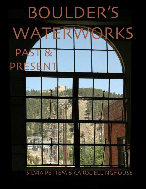
The cover image was taken from the Boulder Canyon Hydro Plant, with a view to the Betasso<br />
Water Treatment Plant in the background. Pettem photo, 2013<br />
ii
<strong>BOULDER’S</strong> <strong>WATERWORKS</strong> –– PAST & PRESENT<br />
INTRODUCTION 1<br />
SETTLEMENT& DITCHES 3<br />
• Boulder City Town Company; Early Ditches, 1859<br />
• First in Time; First in Right<br />
• Municipal Incorporation; Farmers Ditch<br />
PUBLIC <strong>WATERWORKS</strong> & PROBLEMS 11<br />
• Boulder’s First Public Waterworks; City Reservoir #1<br />
• Second Municipal Incorporation, 1878<br />
• New Visions and Plans for the Future<br />
• The Maxwell family and the Silver Lake Ditch and Reservoir Company<br />
NEED FOR NEW RESERVOIRS 23<br />
• City/Sunshine Reservoir #2, 1891<br />
• The “100-Year” Flood and the 1890s<br />
• The Chautauqua Reservoirs: 1898 and 1922-1923<br />
INTO THE 20TH CENTURY 29<br />
• Discovery of Arapaho Glacier<br />
• Watershed Reservoirs and the Lakewood Pipeline<br />
• Water Storage in the Mountains<br />
• Lakewood, Lakewood Reservoir & Tungsten Mining/Milling<br />
• Lakewood Pipeline, Beginnings<br />
• Federal Grants & Water Rights in the Watershed<br />
• Albion Lake Reservoir<br />
BOULDER HYDRO SYSTEM 41<br />
• Barker Dam<br />
• Boulder Hydro Plant, Pipeline, and Penstock<br />
iii
iv<br />
ADDITIONAL WATERSHED DEVELOPMENTS 51<br />
• Silver Lake Pipeline<br />
• Purchase of Arapaho Glacier, 1927<br />
• Infrastructure Development in the 1930s<br />
• Northern Colorado Water Conservancy District<br />
• Silver Lake and Lakewood Pipelines Reconstruction<br />
NEW WATER SUPPLIES & GROWTH, 1950s-1970s 63<br />
• Boulder in the Post-war Era<br />
• Growth Brings Changes, 1950s<br />
• Boulder Reservoir, 1955<br />
• Silver Lake Ditch & Reservoir Agreements<br />
• Blue Line, 1959<br />
• Boulder in the 1960s & 1970s<br />
BETASSO WATER TREATMENT PLANT, 1964 77<br />
• Fluoridation<br />
• Improvements to the Betasso Plant, 1976<br />
• Betasso Treatment Process<br />
BOULDER RESERVOIR WATER TREATMENT PLANT, 1971 85<br />
WATER AND POWER FOR THE FUTURE, 1980s 89<br />
• The Windy Gap Project<br />
• Increasing Use of Barker Reservoir<br />
• Silver Lake Watershed Dams<br />
• Wittemyer Ponds<br />
• Boulder’s New Hydropower Development<br />
• Continued Interest in Environmental Protection<br />
• Protecting Enchanted Mesa<br />
• Protecting Boulder Creek Streamflow & the 1988 Raw Water Master Plan<br />
DEVELOPMENTS IN THE 1990s 97<br />
• Raw Water System Rehabilitation<br />
• Reconstruction of Silver Lake Pipeline & Construction of Silver Lake Hydro<br />
• Implementing the Raw Water Master Plan<br />
• Treated Water Master Plan Updates<br />
• Water Treatment Plant Improvements<br />
• Treated Water System Improvements<br />
• Lawsuits Over the Anderson Ditch<br />
TWENTY-FIRST-CENTURY PROGRESS 107<br />
• Boulder Canyon Hydro––City’s Seventh Hydroelectric Plant<br />
• Repair of the Barker Gravity Line<br />
• Lakewood Pipeline reconstruction<br />
• Lakewood Hydro Plant, 2004
• Water System Security Improvements<br />
• Water Treatment Improvements<br />
• Dealing with Drought<br />
• Expansion of treated water deliveries from Boulder Reservoir<br />
PREPARING FOR THE FUTURE 123<br />
• Water Budget Rate Structure<br />
• More Silver Lake Ditch Issues<br />
• Carter Lake Pipeline II<br />
• Rebuilding the Betasso Pipelines<br />
• Rebuilding Boulder Canyon Hydro<br />
• The Thousand-Year Rain<br />
• Looking Ahead<br />
APPENDIX 133<br />
• Water Utilities Work Program<br />
• Water Resources Advisory Board (WRAB)<br />
ENDNOTES 135<br />
v
vi<br />
For many years, this “Welcome to Boulder” sign hung from a pipe over Broadway, near Norwood Avenue.<br />
The pipe carried water from Silver Lake Ditch. Carnegie Branch Library for Local History, Boulder Historical<br />
Society collection (129-11-44)
INTRODUCTION<br />
The story of Boulder’s waterworks is a long and integral part of the City’s history. Prospectors<br />
used the waters of Boulder Creek to wash their gold-bearing gravels. Farmers, who<br />
“mined the miners,” dug ditches, grew crops, and raised cattle. Boulder was founded on<br />
mining and agriculture, and both needed water.<br />
Water usage became controversial and confrontational. Water rights were determined<br />
by who claimed them first, not by who owned the land crossed by rivers, as in the Eastern<br />
states. The public, rather than private companies, generally won out in controversies over<br />
who should control Boulder’s water distribution.<br />
In the late 1800s, pollution of Boulder Creek caused Boulder to seek cleaner water by<br />
moving its water intake upstream into the mountains and to carry the water into the City<br />
in pipelines. In 1906, the City reached even higher toward the source of Boulder’s water on<br />
North Boulder Creek with the construction of Lakewood Reservoir near Nederland and ten<br />
more miles of pipeline.<br />
The City then began a far-sighted process of acquiring lands to be protected for water supply<br />
almost a century before the practice of source water protection became commonplace.<br />
The properties were located just below the Continental Divide and included the recently<br />
discovered Arapaho Glacier. The threat of contamination continued, however, when the<br />
world’s largest tungsten mill built next door to the City’s newest intake at Lakewood Reservoir.<br />
In 1919, the City extended its pipelines even higher with an intake located within<br />
the City-owned Silver Lake Watershed.<br />
Meanwhile, in 1910, big advances had come in the private sector with the construction of<br />
Barker Dam and Reservoir, along with the opening of the Boulder Hydroelectric Plant in<br />
Boulder Cañon (now Canyon). The hydro plant helped electrify Boulder and, beginning<br />
in the 1950s, became a key part of Boulder’s water supply. But, it would be more than 90<br />
years before the City became owner and operator.<br />
The 1930s brought the Great Depression. For Boulder, the good news was that the unemployed<br />
were hired with federal funds to rebuild infrastructure, including the Works<br />
Progress Administration’s (WPA) biggest local project––Island Lake Dam. The WPA’s work<br />
ended in 1942, when World War II made the program obsolete.<br />
1
In 1947, the first Western Slope water from the Colorado-Big Thompson Project flowed<br />
through the 13.1-mile Alva B. Adams Tunnel, under the Continental Divide. Boulder, not<br />
yet a member of the Northern Colorado Water Conservancy District, eyed its neighbors to<br />
the north. Suddenly, in the years following the end of the war, Boulder’s population exploded,<br />
and everyone demanded more water.<br />
Boulder entered into the Northern Colorado Water Conservancy District in 1953 and built<br />
Boulder Reservoir in 1955. The City’s continued growth brought many more changes.<br />
Water was treated consistently for the first time, in 1964, with the opening of the Betasso<br />
Water Treatment Plant. The Boulder Reservoir Water Treatment Plant followed in 1971.<br />
The City looked to the future with additional water supplies from the Windy Gap Project<br />
in 1985, the same year that Boulder began producing its own hydroelectric power. Then, in<br />
2001, after constructing six of its own hydroelectric plants, the City ended up as owner of<br />
the then-91-year-old Boulder Canyon Hydro Plant in Boulder Canyon. At the time, Boulder<br />
purchased all of the Barker system facilities for water supply purposes. With the construction<br />
of the Lakewood Hydro, in 2004, Boulder now owns and operates a total of eight<br />
hydroelectric plants.<br />
In recent years, the City has been fine-tuning its facilities and maintaining its investments––all<br />
for an end product that can be easy for Boulder’s residents and visitors to take<br />
for granted. The following pages are meant to give readers a better understanding of, and<br />
appreciation of, Boulder’s water––where it comes from, where it’s stored, how it’s treated,<br />
and how it’s used. There were people (and their stories) involved in this process, too, and<br />
some of them are included here, as well. The topic is far from dry.<br />
2
SETTLEMENT& DITCHES<br />
Boulder City Town Company; Early Ditches, 1859<br />
Boulder––first known as the “Boulder City Town Company”––was founded on February 10,<br />
1859 by 54 men who had crossed the Great Plains to seek their fortunes in gold. One of the<br />
prospectors, Alfred A. Brookfield, wrote in a letter home to his wife, “We thought that as<br />
the weather would not permit us to mine, we would lay out and commence to build what<br />
may be an important town.”<br />
A few months earlier, the prospectors had split from a larger band of gold-seekers (bound<br />
for the Cherry Creek “diggings,” now the Denver area) and followed St. Vrain Creek to<br />
Boulder Creek and on to Boulder Canyon. After weeks of traversing the seemingly endless<br />
prairie, Boulder’s first Anglo settlers pitched their tents in the shadows of towering sandstone<br />
slabs that would later be called the Flatirons.<br />
The men had neighbors––the Arapahos. 1 At the time, Colorado, and even Colorado Territory,<br />
did not exist. The Kansas-Nebraska Act of 1854 had placed most of the Boulder area<br />
in Nebraska Territory, with the fortieth parallel (now Baseline Road) the dividing line<br />
between Nebraska and Kansas territories. According to federal decree, all of the land belonged<br />
to the Indians. But, the prospectors were successful in discovering gold, its lure was<br />
strong, and many of the men decided to stay. They elected former Nebraska City mayor<br />
Alfred A. Brookfield as “president.” The “States,” with United States President James Buchanan<br />
was far away.<br />
Boulder County’s early settlers must have been pleasantly surprised when they noticed the<br />
small streams cascading down the Front Range. Although none of the streams were navigable,<br />
they brought enough water to the Boulder Valley to support the native plants that<br />
fed resident buffalo, antelope, and deer. Members of the Southern Arapaho nation had<br />
known for generations that the Boulder Valley was a good place to hunt, as they spent the<br />
winter months there, sheltered by the high mountains from intense weather.<br />
Other Anglos had come before the prospectors. Colonel Stephen H. Long, for whom Longs<br />
Peak is named, reached the Rocky Mountains in 1829 after crossing what he called “The<br />
Great American Desert.” Long described the Great Plains as “a rainless, treeless, wasteland”<br />
and stated that it was “unfit for human habitation.” The next generation of explorers<br />
turned their attention to the Far West, particularly when gold was discovered in California<br />
in 1848. Boulder’s prospectors, like their California predecessors, diverted water from<br />
3
mountain streams when they washed sand and gravel from the heavier particles of gold in<br />
rockers, long toms, and sluice boxes.<br />
Eventually, additional prospectors would find silver, tungsten, and fluorspar, as well, while<br />
other Boulder County inhabitants turned to farming––the occupation they knew best.<br />
Whether they mined or farmed, they needed water.<br />
Boulder County’s economy was founded on mining and agriculture, as depicted in this Art Deco bas relief<br />
sculpture over the front entrance of the present-day Boulder County Courthouse. Pettem photo<br />
Brothers Sylvanus, Luther, and Henry Wellman arrived in Boulder in August 1859. Instead<br />
of prospecting, they predicted that flour would be almost as valuable as gold, and that the<br />
miners would provide a ready market for grains and produce. The men selected 640 acres<br />
of bottom land along Boulder Creek (in the vicinity of what is now Arapahoe Avenue and<br />
the Foothills Parkway), built log cabins, and planted turnips as their first crop.<br />
4<br />
Although the summer was nearly over, the soil was rich and the rainfall, that year, was<br />
plentiful. Then, when the turnips were almost ready to be harvested, they were devoured<br />
by grasshoppers. Undeterred, the brothers planted wheat the following the spring. According<br />
to Amos Bixby, who wrote the earliest account of the county’s history, the Wellmans’<br />
first wheat harvest yielded 45 bushels per acre. 2 Sylvanus Wellman later testified as to<br />
the brothers’ early use of water, and stated that Boulder Creek often overflowed into the<br />
grasslands in the bottoms during flood season. He then added that during the summer of
1859, they dug small ditches from Boulder Creek to irrigate approximately 800 acres.<br />
Meanwhile, in the vicinity of Arapahoe Avenue and 17th Street, Marinus G. Smith and<br />
William G. Pell took up adjoining properties. In October 1859, they plowed the ground for<br />
a joint vegetable garden and dug the Lower Boulder irrigation ditch––the first in Boulder<br />
County. Smith, Pell, Brookfield (who gave up mining for a farm in Valmont), the Wellman<br />
brothers, and others lost no time in determining that the construction of irrigation ditches<br />
from South Boulder Creek, Main Boulder Creek, Left Hand Creek, and St. Vrain Creek<br />
would convey enough water to grow a plentiful supply of crops despite the area’s dry<br />
climate.<br />
By the early fall, in 1859, barely a year after the first Anglo settlers had arrived in the Boulder<br />
Valley, a number of families established the first rights to divert water from Boulder<br />
Creek and South Boulder Creek. Some early and/or prominent ditches from Boulder Creek<br />
are listed below. 3<br />
Priority # Name of Ditch: Date of: Appropriation:<br />
1 Lower Boulder Ditch October 1, 1859<br />
2 Smith & Goss Ditch November 15, 1859<br />
3 Howell Ditch December 1, 1859<br />
4 Anderson Ditch October 1, 1860<br />
5 Godding, et al March 1, 1861<br />
6 Houck #2 Ditch April 1, 1861<br />
Early and prominent Boulder ditches also include:<br />
North Boulder Farmers Ditch June 1, 1862<br />
Farmers Ditch October 1, 1862<br />
Boulder & Left Hand Ditch December 1, 1873<br />
Boulder & White Rock Ditch November 1, 1873<br />
Town of Boulder Ditch June 17, 1875<br />
Silver Lake (Maxwell) Ditch February 28, 1888<br />
First in Time; First in Right<br />
Boulder’s early settlers came from the eastern states where water rights are riparian,<br />
meaning that water can be freely used by landowners adjacent to the stream because<br />
there was enough rain runoff and groundwater flow to always keep rivers running. However,<br />
the west was arid and did not receive the ample rainfall seen in eastern states. Western<br />
streams often dried up in late summer and barely flowed in the winter. Often the most<br />
productive land was not near any stream. So, western water users took their cue from<br />
those who had established water rights in the Far West during the California gold rush.<br />
Colorado water rights did not automatically go along with ownership of land next to the<br />
river, but went to those who put water to use first, no matter where their land was located.<br />
5
“First in time, first in right” became the common law for most western waterways. This<br />
principle was codified as governments formed in the area. Colorado Territory (and its 17<br />
original counties, including Boulder) was created on November 1, 1861. 4 The first-comefirst-served<br />
rule was then affirmed by the Colorado Territorial Legislature in 1862. By 1864,<br />
there were 23 ditch companies that had initiated claims for water rights on Boulder Creek<br />
based on actions taken to physically divert water out of the creek, but there would be a<br />
long way to go before an enforceable water rights system was developed. 5<br />
When Colorado became a state in 1876, its Constitution stated, “The right to divert the<br />
un-appropriated waters of any natural stream to beneficial uses shall never be denied.<br />
Priority of appropriation shall give the better right as between those using water for the<br />
same purpose.” 6<br />
If the miners had not established some system to fairly distribute the water, early Boulder<br />
residents might have resorted to “shovel diplomacy,” a term coined by a Colorado water<br />
attorney, the late George Vranesh, to describe what one miner would do if he discovered<br />
another miner diverting all the water upstream. The first miner simply “walked up the<br />
creek and hit the other miner over the head with his shovel.” 7<br />
This 2012 photo, or the headgate of Left Hand Ditch, shows the diversion dam that moves water from the<br />
South St. Vrain Creek into the Left Hand Ditch. Courtesy Donlyn Arbuthnot<br />
6
“Shovel diplomacy,” however, did play a part in the benchmark case of Coffin vs. Left Hand<br />
Ditch Company, which affirmed the doctrine of prior appropriation––“first in time, first<br />
in right.” The confrontation involved Boulder farmer Reuben Coffin. He and his brother,<br />
George, had owned land next to St. Vrain Creek as early as 1866, but had never declared<br />
any claim to use of the water in the bountiful stream next to their lands. Previously, in<br />
1863, the founding members of the Left Hand Ditch Company had built a dam across St.<br />
Vrain Creek to divert water into James Creek for irrigation of land further downstream off<br />
of Left Hand Creek. This was not a problem in wetter years, but 1879 was a drought year<br />
and Coffin found the St. Vrain to be bone-dry while he watched his corn shrivel in the summer<br />
heat. Enraged, he and a few other farmers went upstream to the company’s dam and<br />
tore it apart. The company rebuilt and Rueben Coffin sued. 8<br />
The case of Coffin vs. Left Hand Ditch Company went all the way to the Colorado Supreme<br />
Court. In 1882, the Court determined that Coffin was out of luck and out of line to have<br />
trespassed on ditch-company property. The court ruled that the Left Hand Ditch Company’s<br />
right to divert water was superior to Coffin’s claim because water was to be allocated<br />
based on date of first use, not proximity of land to the river. 9 The ruling also stated that<br />
the ditch company had the right to divert water from one drainage to another, thus paving<br />
the way for the trans-mountain movement of water in the future.<br />
A lengthy newspaper article on May 5, 1882, probably by Eugene Wilder (editor at the<br />
time) of the Boulder News and Courier, sheds light on how the water appropriation issue<br />
was handled by the press and perceived by the public.<br />
THE WATER QUESTION<br />
(Boulder News and Courier, May 5, 1882)<br />
The resolution adopted for discussion at Longmont two weeks ago will go far<br />
towards establishing a foundation for the water situation. Gradually is it approaching<br />
the standpoint of USE as a basis, and the righteousness thereof becoming<br />
more prevalent and universally conceded. As men consider the matter,<br />
they become convinced that the truth of this view cannot be denied.<br />
Water is a free element given to the people and owned by the people, and there<br />
is no law in the United States that will protect a man or corporation in monopolizing<br />
that which is so necessary to the wants, rights, or liberties of another.<br />
And this great principle, which is the foundation of our institutions, will assert<br />
itself in all cases, and bring conviction with it. A corporation may construct a<br />
ditch and take toll for carrying the water, and the one who uses it is the appropriator––his<br />
priority, however, is a matter of date. He owns the water by right<br />
of use, and should he choose to receive it through another channel can do so,<br />
and who can hinder him?<br />
A man has a farm of 160 acres; in 1874 he may have cultivated 20 acres and<br />
used water sufficient for that amount. In 1876 he may have cultivated 40<br />
acres, and in 1880 he cultivates 80 acres. Now, the neighbor, who comes in<br />
7
1875 and takes water from the same stream, has a priority over the appropriation<br />
of the first man for the additional amount he appropriated in 1876 or<br />
1880. We cannot hold others accountable for our shortsightedness or inabilities.<br />
The word “use,” and an honest appropriation of it, will be the equalizing power<br />
of this intricate question among our people. It must be so; by no other means<br />
can it be settled, and as such must it be finally recognized by the courts. A<br />
company has no right to dam up a stream, run the water through a ditch, and<br />
compel the people to buy it of them or go without. They own the ditch, but the<br />
water, never!<br />
A ditch cannot appropriate water; it is the use of it on the land that does it,<br />
and the man who uses it is the appropriator, and consequently the owner, and<br />
he can have that water recorded to him for his benefit. And no court can, with<br />
justice and human right, deprive him of it. All through the country last season<br />
was fraud perpetrated on the people by fraudulent ditch stock. In many of the<br />
ditches was water sold, thousands of inches more than the ditch could possibly<br />
carry, and many lost their crops.<br />
Now I want to say to the farmers: To you belongs the water by right of use, and<br />
not to the ditches. 10<br />
Municipal Incorporation; Farmers Ditch<br />
As was the case with many Western communities, Boulder was slow to establish a municipal<br />
water supply system separate from the early irrigation ditches that were constructed<br />
through the town. The frontier mining supply town did not consider municipal government<br />
until 1871 and only then because some residents chafed under what they felt to be<br />
dictatorial rulings by the three Boulder County Commissioners, whose offices had been<br />
established in 1861. On November 4, 1871, the name “Boulder City” was dropped, and the<br />
“Town of Boulder” was incorporated. 11 By then, Ulysses S. Grant had become President of<br />
the United States.<br />
In the 1870s, the establishment of the Town’s waterworks was not immediately perceived<br />
as a matter for municipal concern. A few fortunate Boulder residents used water from<br />
their recently dug wells or springs on their property, but most of the rest of the 2,500 city<br />
residents obtained their domestic water from Boulder Creek or from one of the ditches,<br />
while some wealthy homeowners laid pipes (some fashioned from hollow logs) from the<br />
ditches to their residences.<br />
The privately owned Boulder Aqueduct Company was organized in May 1872 by three<br />
of Boulder’s prominent pioneers–– Alfred A. Brookfield, Andrew J. Macky, and James P.<br />
Maxwell. Macky would later become the president of the First National Bank of Boulder,<br />
and Maxwell, a water engineer, would become mayor of Boulder, as well as a Colorado<br />
8
state senator. In January 1873, the aqueduct company was granted a charter by the Town<br />
Trustees. 12 The three businessmen promised to lay wooden water pipes from Farmers Ditch<br />
(completed in 1862) along the principal streets, with pipes leading into the houses whose<br />
owners requested the service. 13 However, they did not get far with their plans for a private<br />
water company because many of Boulder’s citizens believed a water system should be<br />
public.<br />
Farmers Ditch (visible in the foreground) was built in 1862, and its water was piped into<br />
Boulder homes beginning in 1872. This photo of 637 Pine Street was taken in 1973.<br />
Carnegie Branch Library for Local History, Boulder Historical Society collection (207-14-<br />
7#1)<br />
9
10<br />
Arrows point to Farmers Ditch, Silver Lake Ditch, and Anderson Ditch. Drumm’s 1926 map of Boulder County,<br />
Pettem collection
PUBLIC <strong>WATERWORKS</strong> & PROBLEMS<br />
• 1875, Town of Boulder Ditch<br />
• 1875, Town of Boulder Reservoir #1<br />
• 1877, Boulder’s first water supply protective ordinance<br />
• 1879, Town of Boulder Reservoir capacity deemed inadequate<br />
• 1887, Construction began on a new reservoir––City/Sunshine #2<br />
• 1887, James P. Maxwell began construction of Silver Lake Ditch<br />
Boulder’s First Public Waterworks; City Reservoir #1<br />
In 1874, a citizen committee was formed to decide whether the waterworks should continue<br />
under a private company, or if they should be built by the town. Some voted in favor of<br />
the private company, but committee members Frederick A. Squires, Ephraim Pound, and<br />
Alfred A. Brookfield decided that, indeed, the waterworks should be publicly funded. 14<br />
The men proposed an $18,000 bond issue to build a reservoir near the mouth of Boulder<br />
Canyon, southwest of Red Rocks. On October 31, 1874, there were 71 citizens who voted<br />
for the expenditures and 17 voted against. Hotel owner and former Boulder County Sheriff<br />
Ephraim Pound had been elected President of the Town Trustees in 1873 and was appointed<br />
Boulder’s first water commissioner. He served from 1875 to 1877.<br />
Construction began on the Town of Boulder Ditch and the Town of Boulder Reservoir (also<br />
known as Red Rocks Reservoir or Sunshine Reservoir No. 1) in 1875. Martin D. Currigan, a<br />
contractor specializing in plastering and cement work, was in charge of pipe-laying, and he<br />
also built the storage pond which measured 138 feet across and ten feet deep. The intake<br />
was at a headgate at the mouth of Boulder Canyon, on the north bank of Boulder Creek.<br />
Diverted waters flowed through a wooden flume and ditch that soon-to-be-elected President<br />
of the Board of Trustees John A. Ellet dug, in 1875 and 1876, through land acquired by<br />
the City from John Brierley.<br />
The land was located south of Red Rocks, about halfway between Farmers and Silver Lake<br />
ditches. Shortly thereafter, in 1878, another purchase of approximately ten acres of land<br />
was made from John Ryan who owned the land “on which the reservoir is located.” Ellet<br />
charged $2,000 for his work, but the Town Trustees had run out of money. Instead, they<br />
offered Ellet water bonds “with accrued interest thrown in.” 15 The ditch measured three<br />
feet across and one foot deep, with a five-foot-per-mile grade.<br />
11
Hotel owner, former Sheriff, and President of the Town Trustees, Ephraim Pound, was also Boulder’s first<br />
water commissioner, serving from 1875 to 1877. Carnegie Branch Library for Local History, Boulder (420<br />
pound-daniel #2)<br />
12<br />
Before the water flowed into the reservoir, it seeped through a sand filter. From the storage<br />
pond, the water flowed downhill along Pearl Street through a curved cast-iron-eightinch<br />
pipe to Twelfth Street (now Broadway). Later, another eight-inch pipe was run down<br />
to the public square (site of the Boulder County Courthouse), which lay 160 feet below the<br />
elevation of the reservoir. (Boulder replaced some of these pipes in 1917, when a portion of<br />
Pearl Street was paved for the first time.)
Above, the Town of Boulder Reservoir, built in 1875, was also known as the Red Rocks Reservoir and<br />
Sunshine Reservoir #1. The use of the name “Sunshine” is misleading, as the site is accessed through<br />
today’s Settlers’ Park, off of Pearl Street. The Yount flour mill is in the right center of the photo.<br />
Carnegie Branch Library for Local History, Boulder Historical Society collection ( S-936)<br />
Below, the site of the first reservoir looks like this today. Pettem photo, 2013<br />
13
Many Boulder residents got their water at the public square. The trip downtown became a<br />
social event, as citizens took time to visit, perhaps watch a baseball game, and then trudge<br />
home with full pails. With the addition of a few fire plugs, Boulder’s hose companies at<br />
least had a chance to put out the town’s frequent fires rather than stand by and watch<br />
wooden buildings burn to the ground. Boulder’s fierce seasonal winds made the possibility<br />
of a fire a frightening, but common, prospect.<br />
Before long, another bond issue of $12,000 was required to lay pipes to Spruce and Pine<br />
streets. Twelve additional fire hydrants were installed, and firefighters had 140 pounds of<br />
water pressure for their hoses. But the project received a lot of complaints. According to<br />
the Town Minutes, the contractor promised the Town Trustees he would “make tight all<br />
joints, connections, and hydrants now leaking or that may be found to be leaking within<br />
20 days.” 16<br />
The complaints continued. When foundry man J. W. Develine ordered his pipe connection,<br />
only a trickle of water dropped from his new faucet. Upon investigation, a quantity<br />
of swollen corncobs stuffed into the street pipes explained the lack of water. A couple of<br />
years later, Boulder fire hydrant pressure had dropped to ten pounds. A cast-iron main was<br />
dug up on Twelfth Street, and a five-foot length of wood, four and one-half inches wide,<br />
was wedged in such a way that only two-and-one-half inches of pipe were available for<br />
water flow.<br />
Meanwhile, the University of Colorado had been founded, in 1876, on a barren mesa. One<br />
argument to the Colorado Territorial Legislature that Boulder be chosen as its home was<br />
the town’s proposed gift of ten shares of Anderson Ditch water to the University. Every<br />
tree had to be planted and continually watered. Today this irrigation system is still in use<br />
on campus.<br />
In 1877, a “diversion” was built between downtown Boulder and Boulder Creek, so that the<br />
water collecting in the streets might flow back to the stream. The following year, $30,000<br />
was spent to patch up the then-five-mile-long water system, but the town’s water became<br />
more and more clouded with mill tailings from gold and silver workings upstream.<br />
Boulder’s first water supply protection ordinance was passed the same year. Instead of<br />
mentioning minerals, however, it stated, “No person shall put any carcass or filthy animal<br />
or vegetable matter into the reservoir, nor shall any person bathe or swim therein or skate<br />
upon the ice which may form thereon in cold weather.” 17<br />
With the waterworks in place, a number of businesses used water from the new municipal<br />
pipelines, but others continued to rely on the original ditches for their enterprises. One<br />
was Andrew Douty’s grist mill and waterwheel which used Farmers Ditch water to grind<br />
flour for bread. The Boulder County News had started using a water-powered typesetting<br />
machine in 1874. Meanwhile, pipes were laid to schools and other public buildings.<br />
14
<strong>BOULDER’S</strong> EARLY <strong>WATERWORKS</strong> PRESENTED PROBLEMS<br />
by Silvia Pettem (Daily Camera, August 15, 2002)<br />
In 1882, banker Charles Buckingham was taken to police court and fined<br />
nine dollars for watering his lawn between the hours of 9a.m. and 4p.m. Like<br />
his Pine Street neighbors, he was prohibited by a city ordinance from “using<br />
water from the Boulder City waterworks through a hose and sprinkler” during<br />
the daytime. Water has always been a precious commodity in Boulder, and the<br />
watering restrictions that we have today are nothing new.<br />
Boulder’s earliest settlers realized that their semi-arid climate required a<br />
dependable source of water, but they didn’t find it in the 19th century. At first,<br />
the town founders dug irrigation ditches, not only for their farmlands but for<br />
their domestic water, as well.<br />
Farmers Ditch was one of the earliest waterways and began at a head-gate on<br />
Boulder Creek near the mouth of Boulder Canyon. The ditch then meandered<br />
through the Mapleton Hill area before flowing northeast of Boulder and out<br />
to the plains. Within the city, side ditches, called laterals, supplied water to<br />
neighborhoods downtown.<br />
The ditch, still in place but intermittently covered, was an improvement over<br />
hauling water from the creek, but it was convenient only when the water<br />
flowed. In 1869, an early newspaper reported, “There is no water running in<br />
the Farmers Ditch which should supply the tidy housewives of Boulder who<br />
are grumbling considerably.”<br />
Before long, it became evident that Boulder needed a more permanent water<br />
works than Farmers and the other ditches could supply. In 1874, residents<br />
had approved a bond issue to finance the building of a small reservoir near<br />
the mouth of Boulder Canyon and to fill it from another intake ditch farther<br />
upstream. Soon its water flowed underneath Pearl Street through an eightinch<br />
cast-iron water main. Another bond issue financed pipes that were laid to<br />
carry water to the cross streets.<br />
“Boulder can already claim to have better water works than any city in the<br />
Territory,” stated the Colorado Banner, in 1875, a year before Colorado became<br />
a state. “The pressure is enough to throw it over any house that ever will<br />
be built in Boulder.” 18<br />
At the time, water rates cost homeowners ten dollars per year for a house with<br />
five rooms or less. Each additional room added an extra dollar to the bill. Additional<br />
annual rates for lawn sprinkling were 15 cents per linear foot (along the<br />
street). Gardens were rated at one cent per square yard. By 1878, Boulder’s<br />
water lines had been extended throughout most of the downtown area.<br />
In 1882, when Boulder initiated its first watering restrictions and Bucking-<br />
15
ham was hit with his fine, the municipal water supply was clouded with mill<br />
tailings. Two years later, the newspapers reported that the City’s water was<br />
“murkier than ever,” then it was temporarily shut off when dead horses were<br />
found in the creek. Town leaders began to talk of an entirely new system.<br />
The situation was expected to improve in 1891 when the City built the Sunshine<br />
#2 Reservoir at the mouth of Sunshine Canyon. According to newspaper<br />
reports, its intake pipes were several miles “up in the mountains.”<br />
The water situation, however, went from bad to worse. The Camera stated that<br />
city council members, who had described themselves as a “committee of the<br />
whole,” renamed themselves a “committee of the hole” because they claimed<br />
that instead of water, they saw only “mud and microbes.”<br />
16<br />
Second Municipal Incorporation, 1878<br />
Boulder’s governmental structure underwent several changes with a second incorporation<br />
in 1878. Although the changes didn’t affect the waterworks, Colorado had been granted<br />
statehood in 1876, and the state legislature provided for incorporation of cities under<br />
state, rather than county, statutes. The President of the Town Trustees became known as<br />
the Mayor, and the city limits were extended to include all of the additions that had been<br />
platted since 1871. 19<br />
Even though the town now had a pressurized municipal pipe system, the cobblestone-lined<br />
laterals running from the Farmers Ditch continued to play an important water supply role.<br />
These small ditches bordered Pearl and neighboring streets and measured two feet wide<br />
and eight inches deep. They served to water horses, wandering cattle, and pigs, as well<br />
as providing a small amount of water for firefighting or to settle the summer dust on the<br />
streets. Small boys were known to have used the waterways to wash their feet. One newspaper<br />
reporter stated that, sometimes, water was allowed to run down the streets for no<br />
discernible reason, where it formed “nauseating puddles.” 20<br />
Due to the on-going importance of the laterals, as well as the seniority of the 1862 Farmers<br />
Ditch right to divert from Boulder Creek, as compared to the right established in 1875 for<br />
the Town of Boulder Ditch, the Town Trustees decided to pursue purchase of shares in the<br />
Farmers Ditch Company. On October 23, 1879, the Town Trustees set aside 50 dollars to<br />
buy 20 shares of Farmers Ditch stock, but the ditch company shareholders with whom the<br />
Town was negotiating––James P. Maxwell, Austin Smith, James H. Carle, Joseph Wolff, and<br />
Frederick A. Squires refused to sell any of their shares. On November 3, 1879, the trustees<br />
offered $1,000 for ten shares. Again, the ditch shareholders backed off.<br />
By January 5, 1880, however, the Town of Boulder had purchased three and one-half<br />
shares of Farmers Ditch water, followed by another four and one-half shares for a total<br />
cost of $800. 21
Ditch laterals paralleled 12th Street (now Broadway), near its intersection with Pine Street, when<br />
this photo was taken in the 1890s. Carnegie Branch Library for Local History, Boulder Historical<br />
Society collection (207-4-42 #1)<br />
Most Boulder residents, however, were still drinking untreated creek water delivered from<br />
the Town of Boulder Reservoir into the municipal water system, even though it was becoming<br />
more and more clouded with mill tailings. A writer for the Herald recommended<br />
that the water be taken out at a higher point in the canyon to avoid mining and milling<br />
debris. Even so, thirsty shoppers drank from downtown fountains. A few householders also<br />
erected, in front of their homes, ornamental fountains––Boulder’s new status symbols.<br />
By 1879, the City’s first reservoir was declared inadequate for Boulder’s growing needs. As<br />
a stop-gap measure, the City ordered that the reservoir be enlarged to a depth of 18 feet,<br />
a width of 150 feet, and a length of 200 feet. However, the Town Trustees continued to<br />
discuss the need for a new reservoir in a better location.<br />
Many ditch companies were becoming interested in building reservoirs as well. Water<br />
users were beginning to realize that storing water for future use was essential because<br />
the natural flow of Boulder Creek swelled with snowmelt from May to July, but dropped<br />
to ankle-deep levels the rest of the year. So many water rights had been claimed on Boulder-area<br />
creeks by the late 1860s that there were more demands for water in late summer<br />
than was in the creeks. Only the earliest ditches could continue diverting when water<br />
levels dropped. There were sometimes disputes over who had the more senior water right<br />
because no state or court approved priority list existed. Ditch companies with more junior<br />
17
water rights began building reservoirs in the 1880s to store spring runoff water for late<br />
irrigation season use.<br />
New Visions and Plans for the Future<br />
Colorado Governor Frederick W. Pitkin appointed Boulder farmer and stock-raiser Hiram<br />
Prince as the state’s first Water Commissioner, in 1880. A few years later, while serving in<br />
the state legislature, Prince would become known as an advocate––far before his time––of<br />
the trans-mountain movement of water.<br />
By 1882, Boulder’s population had reached 3,000, and the frontier town was re-incorporated<br />
again. This time Boulder became a “city of the second class.” Elected officials were<br />
Mayor, Treasurer, and four Aldermen (formerly known as Trustees). Together they formed<br />
the City Council. 22 Then, on June 2, 1882, local water rights were adjudicated (officially recognized<br />
and quantified) for the first time by the Boulder County District Court.<br />
During many of the previous months, water users who had diverted from Boulder-area<br />
creeks had been giving testimony about when they started using water, how much was<br />
used and where it was used. Ninety-eight ditch companies were accorded priority rights to<br />
use water in order of priority depending upon the dates when the ditches were first built. 23<br />
The decrees that were issued had limits on how much water each ditch could take based on<br />
the size of the ditch. The companies were owned by their shareholders and delivered water<br />
for irrigation of shareholder land within the service area of the ditch. The new City of<br />
Boulder was granted a decree with an 1875 appropriation date for the old Town of Boulder<br />
Ditch that specifically allowed domestic use, which is unusual because the Colorado Legislature<br />
did not actually provide for adjudication of any water uses besides irrigation until<br />
1903.<br />
Boulder farmer and stock-raiser, Hiram<br />
Prince, was appointed the state’s first<br />
Water Commissioner in 1880.<br />
Photo from Portrait & Biographical Record<br />
of Denver and Vicinity<br />
18
A few weeks later, the City Council met to discuss what the local newspaper called “two<br />
matters of importance.” One was the construction of the first downtown railroad depot<br />
and the other dealt with water. After urging the building of the depot, the Boulder News<br />
and Courier stated:<br />
EDITORIAL (Boulder News and Courier, July 7, 1882)<br />
The other matter of importance is that of enlarging the water main, as eloquently<br />
urged by Major Whiteley at the dedication of Fireman’s Hall the other<br />
evening. 24 It is assumed that there will be some objections, on the ground of<br />
the great expense, but there was that objection to this town’s constructing<br />
water works in the first place. It is an objection which all public enterprises<br />
have to face. Let it be faced down by the forward-looking, progressive spirit of<br />
the town. 25<br />
As a result, City Council members, in 1883, proposed a $50,000 bond issue to rebuild the<br />
waterworks. A Boulder County Herald writer stated, “The system could not be improved in<br />
part, but must be made entirely anew. The water question is getting to be a serious one.” 26<br />
The Herald noted that after dead horses had been found in the creek upstream, the water<br />
had to be turned off entirely for a short time. As soon as it was on again, residents continued<br />
to drink it. A physician recommended that households filter their drinking water and<br />
a university professor suggested a formula of alum and soda which, he said, would “settle<br />
95 per cent of the dirt in 20 minutes.” 27 (Formulations of alum and soda are still commonly<br />
used in water treatment processes today.)<br />
Another problem lay with the aging Town of Boulder Reservoir. In 1886, a group of enraged<br />
citizens visited the City Council to demand a new reservoir. Amid great controversy<br />
and debate, a $150,000 bond issued passed––459 votes in favor to 39 votes against. Residents<br />
hoped this would clear up the water problem for good.<br />
In 1887, excavation began on the new reservoir, located nearer the base of Sunshine Canyon<br />
on land newly acquired by the City. The site was 100 feet higher than that of the old<br />
reservoir. Dirt from the excavation was carted down to Pearl Street to fill in potholes.<br />
Boulder’s residents were optimistic that this would clear up the water quality problems for<br />
good. However, the troubled municipal water system was still not considered adequate to<br />
support new development and city leaders were reluctant to approve any new extensions<br />
of water mains. This left James P. Maxwell and his partner, George Oliver, high and dry<br />
without a water supply for their proposed development on Mapleton Hill.<br />
The Maxwell family and the Silver Lake Ditch and Reservoir Company<br />
James P. Maxwell was involved in both private and public water projects. As previously<br />
mentioned, in 1872, he was one of the founders of the Boulder Aqueduct Company. Then,<br />
in 1875, he surveyed the Town of Boulder Reservoir site and began a long career in public<br />
19
service. From 1876 to 1880, Maxwell served his first term as state senator, overlapping the<br />
years 1878 to 1880, when he also was Boulder’s mayor. 28<br />
Meanwhile, Maxwell had purchased 15 acres of North Boulder land known as the “Maxwell<br />
Addition.” In order to develop his subdivision and make it attractive to prospective buyers,<br />
he needed water, but the City refused new connections. Maxwell and his partner George S.<br />
Oliver (listed as a feed store clerk in the 1880 federal census) formed a plan to build reservoirs<br />
high in the mountains and deliver stored water for the elegant new Mapleton Hill<br />
residences through a ditch on higher ground than the existing Farmers Ditch.<br />
Laborers are shown, in 1888, constructing the wooden flume for the Silver Lake Ditch in Boulder Canyon.<br />
The line of the narrow gauge railroad (then the Greeley, Salt Lake & Pacific) is visible between the flume and<br />
Boulder Creek. Carnegie Branch Library for Local History, Boulder (511-2-1 #1)<br />
20<br />
In 1887, Maxwell and Oliver began construction of Silver Lake Reservoir near the headwaters<br />
of North Boulder Creek northwest of Nederland, just below the Continental Divide. At<br />
the outlet of the natural Silver Lake, the men built a dam of earth, rock, and timber which<br />
held back some water, but, more importantly, it established their claim to the water. 29<br />
Maxwell also stocked Silver Lake with fish. 30<br />
In 1888, the men formed the Silver Lake Ditch and Reservoir Company to deliver water<br />
throughout Mapleton Hill and to the lands north of Boulder. Their Silver Lake Ditch ran on<br />
the far western edge of Boulder and wound through Mapleton Hill. In 1890, the company<br />
would begin construction on a second mountain reservoir, Island Lake.
Silver Lake Ditch had five wooden flumes (stretching 1,300 feet) pinned to the walls of<br />
Boulder Canyon, as well as a 185-foot-long tunnel dug through a rock formation known as<br />
Elephant Buttress. 31 Beginning in the 1890s, laterals from the ditch watered maple saplings<br />
that Maxwell had planted along Mapleton Avenue.<br />
The Silver Lake Ditch Company was different from other ditch companies since it was a<br />
for-profit company owned solely by Maxwell and Oliver. (Maxwell later bought out his<br />
partner and became the sole owner of the company.) The company delivered water under<br />
paid contracts to specific parcels of land and did not allow the contract water users to use<br />
that water anywhere else. Other companies were mutual ditch companies whose water<br />
rights were considered to be owned by the shareholders of the ditch companies and company<br />
shares could be freely bought and sold for use on other land served by the ditch.<br />
This distinction would prove important in 1906 when Maxwell entered into a contract selling<br />
all of the mountain reservoirs and storage water rights to the City of Boulder. Individual<br />
contract water users of the Silver Lake Ditch then became reliant on Boulder to deliver<br />
water from city-owned sources to the ditch under the terms of a separate city/company<br />
contract. (Maxwell later sold the company to the Degge family who then sold it to contract<br />
water users.) During the next decade, the ditch’s five wooden flumes were replaced<br />
with the steel pipes that now hang on the walls of Boulder Canyon. 32<br />
James P. Maxwell knew Boulder’s waterworks<br />
both as a private investor and as a<br />
public official. Carnegie Branch Library for<br />
Local History, Boulder Historical Society collection<br />
(220-5-4)<br />
James P. Maxwell filed for a land patent from the federal government that encompassed<br />
Silver Lake and Island Lake, high in the mountains above 10,000 feet. In 1896, he received<br />
title from the federal government for 160 acres. Maxwell was actively involved in water<br />
issues for the rest of his life. In the early 1890s, he was also state engineer, having authority<br />
over all of Colorado’s irrigation diversions. He then became an active player in efforts to<br />
improve Boulder’s municipal water supply sources in the early 1900s.<br />
21
22<br />
The locations of both the first Town of Boulder/Sunshine Reservoir and the second<br />
City/Sunshine Reservoir are indicated on this section of Drumm’s 1915 City of Boulder<br />
Map. The first reservoir was completed in 1875; the second in 1891. Silver Lake<br />
Ditch was completed in 1888. Carnegie Branch Library for Local History, Boulder<br />
Historical Society collection, Drumm’s 1915 City of Boulder map
NEED FOR NEW RESERVOIRS<br />
• 1891, Opening of the City/Sunshine #2 Reservoir<br />
• 1898, Construction began on Chautauqua Reservoir #1<br />
• 1922, Construction began on Chautauqua Reservoir #2<br />
City/Sunshine Reservoir #2, 1891<br />
In March 1890, a committee was formed to recommend ways to improve the quality and<br />
reliability of the City’s water. The committee recommended moving the intake that would<br />
feed the City’s new reservoir further upstream. 33 The new reservoir to replace the Town of<br />
Boulder/Red Rocks/Sunshine Reservoir #1 became known as the City/Sunshine Reservoir<br />
#2 and was projected to hold five-million gallons of water. Flagstone was used to pave<br />
the reservoir sides. A small stone tower, containing a control valve, was constructed near<br />
the center of the reservoir and was connected to land by a wooden pier. A new 20-inch<br />
pipe was laid into Boulder in March 1891. One merchant was so thrilled with the prospect<br />
of clean water that he offered a sale on “the greatest bargains in Pure Toilet Soap ever<br />
known.” 34<br />
Plans for the new reservoir were somewhat deficient, however, because no one thought,<br />
at first, to line the bottom with cement. The Daily Camera, during its first year, in 1891,<br />
described a trip by City Council members to what its editor called the “much-maligned<br />
reservoir.” 35 Finally, in 1893, after extensive discussion in the City Council chambers, the<br />
City/Sunshine Reservoir #2 was lined, but the City had to ask its residents for an additional<br />
$50,000 in a bond issue, even though it had not yet spent all of the original $150,000 in<br />
what a newspaper writer called a “gaudy show of economy.” 36<br />
Heeding the advice of the editor of a competing newspaper, the Boulder County Herald,<br />
the intake for the City/Sunshine Reservoir #2 was moved to a natural settling basin above<br />
the community of Orodell (originally named Orodelfan), in Boulder Canyon, just beyond<br />
the intersection of Four Mile and Boulder creeks. 37 The City hired laborers to build a crude<br />
dam of cement sacks and constructed a wooden flume of yellow pine which measured 200<br />
feet long, four feet wide, and three feet deep. A flume was required to measure the flow of<br />
water and make sure that diversions didn’t exceed the amounts in the City’s water rights.<br />
This intake was sometimes called the Blanchard Intake, since the owner of Blanchard’s<br />
Lodge (later the Red Lion Inn) homesteaded 160 acres, including the future Betasso Ranch.<br />
(This intake would later be called the Lower Intake when the City began diverting even<br />
further upstream.) New piping from the intake to the reservoir was laid on higher ground,<br />
which required another land purchase. However, water problems continued.<br />
23
24<br />
Above, excavation of the City/Sunshine Reservoir #2 began in the late 1880s. Below, the City/Sunshine #2<br />
Reservoir was a destination for these ladies when this photo was taken shortly after the reservoir’s completion<br />
in 1891.<br />
Both photos, Carnegie Branch Library for Local History, Boulder Historical Society collection (Above, S-937,<br />
below S-939)
Continued population growth in Boulder forced the City to re-open the first (Town of<br />
Boulder) reservoir for a short time. Again there were complaints of murky water. The Water<br />
Superintendent (whose title had changed in 1887 from Water Commissioner to avoid<br />
confusion with the new state employees who regulated water users on the rivers) solved<br />
the problem, at least temporarily, and called for the use of the City/Sunshine Reservoir #2<br />
water during the day when the customers could see it and the use of the “old reservoir”<br />
water at night when they could not.<br />
After all of the bridges had washed out in the 1894 flood, this makeshift conveyance transferred people (and<br />
kegs of beer) across Boulder Creek. Carnegie Branch Library for Local History, Boulder Historical Society collection<br />
(225-1-8)<br />
The “100-Year” Flood and the 1890s<br />
The City/Sunshine Reservoir #2 was never a danger to Boulder residents, but after what<br />
was later called the “100 Year” flood, in late May 1894, a rumor circulated throughout the<br />
City that the reservoir had burst. The Daily Camera gave the following account on June 1,<br />
1894, when flood waters were at their highest:<br />
THEY TOOK TO THE HILLS (Daily Camera, June 1, 1894)<br />
When the report was set in motion by George Whitney rushing frantically<br />
down the street crying, “Get to the hills; the reservoir is busted!” it spread like<br />
wild fire. Pete Werley rushed home in great haste and met his pale and anxious<br />
wife and children. “Get to Lovers Hill [now Sunset Hill]!” exclaimed Peter.<br />
25
“Get there quick!” and then he repeated the order to his anxious neighbors.<br />
Brother Wangelin and his family were already there, and Otto had kindly told<br />
his neighbors of their great danger so that when Pete arrived, he counted no<br />
less than 75 terror-stricken Boulderites, viewing the waste places from on<br />
high.<br />
When, after a few hours, word came that the reservoir had not really and truly<br />
burst, they cautiously descended and each and every one of them still lives<br />
and will tell the story, let us hope, to future generations with the same modesty<br />
as now makes their discourse on this subject. 38<br />
With a fair amount of bond issue money then currently at hand, the City, in 1894, concentrated<br />
upon improving its water supply lines. A steam-powered pumping station, located<br />
at the intersection of Ninth Street and Aurora Avenue, supplied the line to University Hill,<br />
since gravity alone could not deliver water with enough force to those areas. Eventually,<br />
after the turn of the twentieth century, that portion of the waterworks was re-designed so<br />
that the pumping station was no longer needed.<br />
In 1896, a visitor from Iowa was impressed with the City’s waterworks, and his, or her,<br />
comments ended up in the Daily Camera. “The City’s water supply comes from an open<br />
reservoir 200-to-300 feet higher than the town, which is supplied through pipes reaching<br />
several hundred feet still higher, several miles up the mountain,” stated the tourist. “It is<br />
snow water and is the cleanest, purest, and softest water we have ever seen.” 39<br />
Even so, there still were problems with Boulder’s water quality. In 1897, a local laundry<br />
sent the City a bill totaling $7.50 for “hauling water while city water was muddy.” 40 Contamination<br />
continued to seep into Boulder Creek. During the winter of 1895-1896, the City<br />
laid its first sewer main.<br />
The year of 1898 brought the opening of Chautauqua Park, bringing many new seasonal<br />
visitors. And, the City Council saw a need for another city reservoir.<br />
26<br />
The Chautauqua Reservoirs: 1898 and 1922-1923<br />
A group of Texans built Chautauqua Park on the hillside south of Park Avenue (now Baseline<br />
Road). Boulder’s Chautauqua was part of a national movement of educational and cultural<br />
summer resorts, with speakers and entertainers who traveled the Chautauqua circuit.<br />
To accommodate them, the first buildings were the auditorium and dining hall, both still<br />
in use today. During the early years, guests stayed in tents which, gradually, were replaced<br />
with cottages. But even before most out-of-town visitors had roofs over their heads, excavation<br />
had begun on the first Chautauqua Reservoir, located at the very southern, and<br />
uphill, end of the settlement. Water for the first Chautauqua Reservoir came from two<br />
sources––a ditch that had been dug from Gregory Canyon and a line (with a boost from<br />
the Ninth Street pumping station) from the pipes in Boulder Canyon. 41
In Boulder, laborers replaced pipes, first in south Boulder in 1904 and then in north Boulder<br />
in 1905. They installed split pipelines from the Lower Intake at Orodell––a 16-inch line<br />
swung north to Sunshine Reservoir and a 12-inch pipe ran to the Chautauqua Reservoir.<br />
(Pipes from Orodell to Sunshine Reservoir were replaced again in 1922, 1926, and 1928.<br />
Lines to the second Chautauqua Reservoir also received attention in 1934, 1945, 1940, and<br />
1946.) Another 12-inch pipe went down to the business district.<br />
The first Chautauqua Reservoir, built in 1898, was filled in with soil when Chautauqua Reservoir<br />
#2 was constructed in 1921-1922. (After 1948, eight houses were built on the filled-in<br />
former reservoir ground.)<br />
When the Chautauqua Reservoir (left of center) was constructed in 1898, Chautauqua was basically a tent<br />
city. The auditorium is on the right. Carnegie Branch Library for Local History, Boulder Historical Society collection<br />
(212-1-44 #8<br />
In Boulder, laborers replaced pipes, first in south Boulder in 1904 and then in north Boulder<br />
in 1905. They installed split pipelines from the Lower Intake at Orodell––a 16-inch line<br />
swung north to Sunshine Reservoir and a 12-inch pipe ran to the Chautauqua Reservoir.<br />
(Pipes from Orodell to Sunshine Reservoir were replaced again in 1922, 1926, and 1928.<br />
Lines to the second Chautauqua Reservoir also received attention in 1934, 1945, 1940, and<br />
1946.) Another 12-inch pipe went down to the business district.<br />
The first Chautauqua Reservoir, built in 1898, was filled in with soil when Chautauqua Reservoir<br />
#2 was constructed in 1921-1922. (After 1948, eight houses were built on the filled-in<br />
former reservoir ground.)<br />
27
28
INTO THE 20TH CENTURY<br />
Discovery of Arapaho Glacier<br />
On July 14, 1900, Boulder druggist and future Chamber of Commerce Secretary Eben G.<br />
Fine was visiting the owner of a mine in the vicinity of Silver Lake. Fine couldn’t find anyone<br />
to hike with him, so he set off alone from the lake. He headed for South Arapaho Peak<br />
and decided to cross what Boulder residents then called “the big snow bank” (visible from<br />
parts of the city).<br />
When Fine reached the middle of the snow bank, he realized that he was standing on a<br />
living glacier. In his book Remembered Yesterdays, Fine noted, “If the glacial character of<br />
that snowfield had ever been suspected, certainly no word had ever appeared in print.” 42<br />
He added that he was so excited that he nearly fell into one of the crevasses, but he made<br />
it home safely and stated, years later, that the discovery of a glacier was a splendid way to<br />
bring in the new century.<br />
Darwin M. Andrews (left) and Herbert N. Wheeler (right) were photographed, in 1897, in Barker Meadows<br />
(site of the Barker Reservoir) east of Nederland, on their way to the Silver Lake area. Carnegie Branch Library<br />
for Local History, Boulder (513-2-12<br />
29
However, Herbert N. Wheeler (on a botanical expedition) claimed that, three years earlier,<br />
he and Darwin M. Andrews––not Fine––had been the true discoverers of the Arapaho<br />
Glacier. In his memoirs, Wheeler wrote of the hike the men took during the last week of<br />
August 1897.<br />
EXCERPT FROM THE MEMOIRS OF HERBERT NEWELL WHEELER<br />
D.M. Andrews and I took his burro and walked up to Camp Albion, an old mining<br />
camp in a valley across the ridge to the north of Silver, Island, and Goose<br />
lakes. He wanted to get some bulbs of dogtooth violet from the valley floor at<br />
the head of the Silver Lake area. After getting the bulbs, he said he had always<br />
wanted to see what was at the head of that valley, so we went on beyond the<br />
last lake and climbed up the steep slope of rocks and ice. After reaching the<br />
top, we walked toward the north and soon came upon cracks in the ice, at first<br />
a few inches wide and then several feet wide, rather terrifying. Darwin said<br />
this is a glacier. We dropped rocks down into the crevasses but didn’t hear<br />
them strike bottom. 43<br />
Early (and unidentified) hikers<br />
explored Arapaho Glacier in 1912.<br />
Carnegie Branch Library for Local<br />
History, Boulder Historical Society<br />
collection (141-9-32 #1)<br />
30
In 1904, glacier hikers even included ladies in long dresses! Carnegie Branch Library for Local History, Boulder<br />
Historical Society collection (S-2037)<br />
Watershed Reservoirs and the Lakewood Pipeline<br />
• WATER STORAGE IN THE MOUNTAINS<br />
• LAKEWOOD, LAKEWOOD RESERVOIR & TUNGSTEN MINING/MILLING<br />
• LAKEWOOD PIPELINE, BEGINNINGS<br />
• FEDERAL GRANTS & WATER RIGHTS IN THE WATERSHED<br />
• ALBION LAKE RESERVOIR<br />
Regardless of who had been the first to walk on the glacier, the early 1900s was a time<br />
when Boulder began to collect water rights, reservoir storage rights, and watershed lands<br />
in earnest. According to the 1900 census, Boulder’s population had nearly doubled in the<br />
preceding decade, and the Sunshine and Chautauqua reservoirs were viewed as inadequate<br />
for a growing city of 6,150 people. A drought in 1902 made the situation more urgent and<br />
restricted water use. Water-powered motors in printing plants and other industries were<br />
shut down, and heavy water users were told to conserve.<br />
31
WATER STORAGE IN THE MOUNTAINS<br />
In September 1902, the City Council voted to visit Silver Lake to investigate the possibility<br />
of obtaining water storage high in the mountains. 44 Due to the on-going water quality<br />
problems near the mouth of Boulder Canyon, it was decided to look into moving the intake<br />
for city pipelines up to North Boulder Creek, above its confluence with Boulder Creek.<br />
Even then, however, the Silver Lake area wasn’t a pristine wilderness. The North Boulder<br />
Creek watershed was impacted by runoff from the mining camp of Albion that flowed into<br />
Silver Lake. There, 19th-century mines produced lead, silver, and a small amount of gold.<br />
In addition, there were roads and the dams at Silver and Island lakes that had been built<br />
by James P. Maxwell. These dams raised the water levels in the easternmost of the natural<br />
lakes that had been gouged out thousands of years ago by glaciers. Maxwell’s oldest son,<br />
Clint Maxwell, had also embarked on a dam construction project in 1901. Clint had placed<br />
a small, eight-foot high dam downstream of a natural lake (called Oval Lake) to raise the<br />
lake level and create the predecessor to what would become Goose Lake.<br />
In February 1903, James P. Maxwell, who had become City Engineer at the time, proposed<br />
to the City Council that he and the City of Boulder form a public-private partnership with<br />
regard to his storage right in Silver Lake. The Daily Camera published his comments.<br />
“WATER MORE WATER SAYS THE COUNCIL”<br />
Proposition of ex-Senator Maxwell for Construction of a Dam on Silver and<br />
Goose Lakes, Near the Snowy Range––If Lawyers and Engineers Approve It,<br />
The Proposition Will Be Accepted by the City<br />
(Daily Camera, February 5, 1903)<br />
“The Silver Lake Ditch and Reservoir Company will grant to the City of Boulder<br />
a perpetual lease or other good and sufficient contract to one-half of its water<br />
storage right in Silver Lake Reservoir,” he[James P. Maxwell] stated, “on<br />
the condition that the City of Boulder shall build and maintain at the present<br />
site of the Silver Lake Reservoir a good and substantial structure of such material<br />
as may be agreed upon and of sufficient height and body to impound 25<br />
feet in depth of water above the floor of the present discharge flume in the dam<br />
now constructed. 45<br />
32<br />
The offer was not acted on by the City, possibly because it required the City to pay for the<br />
construction of a new and larger dam to replace the leaky timber-crib dam built in 1887.<br />
Maxwell did not even have any decreed water storage right, since the courts had not yet<br />
issued decrees for any reservoirs in the Boulder Creek basin. 46 If the City followed through,<br />
it would not have any ownership in the new dam it built, the land at Silver Lake, any decreed<br />
water rights, or in water stored behind the dam. Basically, all Maxwell was offering<br />
the City was the privilege of building a sturdy new dam for his company to impound water<br />
at its reservoir site in exchange for leasing the right to use water that might eventually be<br />
stored in any new reservoir space.
The Maxwells also made a similar proposal for Clint’s reservoir at Goose Lake, but, after<br />
much debate, both partnership offers were turned down. At this point, the Maxwells<br />
reached an agreement with the City to sell some of their Silver Lake area properties that<br />
were not needed to provide water supplies for James P. Maxwell’s Boulder developments.<br />
The City’s initial purchase––$15,000 in 1904––was from Clint Maxwell for land surrounding<br />
Triple Lakes (three natural lakes with no dams) and Oval/Goose Lake. 47 In January 1906,<br />
the City also purchased, from James P. Maxwell, land near the Albion mining camp for<br />
$12,000. 48<br />
James P. Maxwell continued to negotiate with the City about the Silver Lake property, but<br />
discussions turned to proposals that would sell full ownership of the land and reservoirs at<br />
Silver and Island lakes to the City. The negotiations were complex since Maxwell wanted to<br />
sell all of his interests in the Silver Lake Ditch and Reservoir Company, including the ditch,<br />
but the City was only interested in buying the reservoirs. Maxwell needed the City to agree<br />
to a contract committing to provide enough reservoir water (from what would become<br />
the City's reservoirs) to satisfy the contracts that his company had already signed with<br />
water users along the Silver Lake Ditch. On January 17, 1906, it appeared that negotiations<br />
had reached an end. The following day, a writer for the Daily Camera reported:<br />
EDITORIAL (Daily Camera, January 18, 1906)<br />
Mr. Maxwell says that he is weary with jockeying about Silver Lake and he<br />
proposes now to keep the property for himself. The incident was formally<br />
closed when City Attorney [Henry O.] Andrew last night told the Council of<br />
Mr. Maxwell’s withdrawal of the option. Of course, the only thing to do now is<br />
to try and see if a dam at Goose Lake will impound enough water for the city’s<br />
uses.<br />
We believe, however, that the very first proposition that should have been undertaken<br />
was the securing of the services of some eminent engineer from outside<br />
the city or state, to pass on the entire subject matter. The episode which<br />
has just closed in the discouragement of the people and defeat of the mayor<br />
and Council is deeply to be deplored. Some day, Silver Lake or some such body<br />
of water or reservoir site will bring a price from Boulder’s taxpayers that will<br />
require some six figures to express. 49<br />
This may have been posturing on Maxwell’s part since (by the end of January, 1906) the<br />
City and the company had entered into an agreement for the City to purchase Silver Lake<br />
and Island Lake for $34,000. The Deed for the transaction included the sale to the City of<br />
the land surrounding the reservoirs and “…all water rights, storage rights, water decrees,<br />
reservoir decrees, and filings, and filings for further storage of water and all other rights<br />
of every kind and nature whatsoever…owned by [Silver Lake Ditch and Reservoir Company]….”<br />
50<br />
33
The obligation to satisfy contract holders under the Silver Lake Ditch remained with the<br />
company, to be satisfied through the contractual right to use any water from the City’s<br />
first annual fill of space located above the Silver Lake and Island Lake outlet works and<br />
imaginary elevation planes located several feet above the outlets. 51 This left the City with<br />
the right to use first-fill water stored in the space above these elevation planes and below<br />
the tops of the dams. The City also gained the right to use water from any reservoir space<br />
that could be refilled during the course of the year and any first-fill water not used by the<br />
company, as well as any water below the outlet in the natural lake area that the City could<br />
manage to access. 52<br />
The contract further stated that the City’s obligation to deliver water to the company<br />
would decline over time as contract holders abandoned use of their Silver Lake Ditch water<br />
or were supplied by other water sources, such as by annexation to the City. 53<br />
(In 1908, Clint Maxwell sold the remaining assets of the Silver Lake Ditch and Reservoir<br />
Company to W. W. Degge, developer of a subdivision named Wellington Gardens. These<br />
assets were a direct-flow right for the Silver Lake Ditch, the ditch structure itself, and the<br />
contract with the City to have storage water released for ditch company use. Degge’s property<br />
was located on the east side of 12th Street––now Broadway––north of the County<br />
Poor Farm that was located northeast of today’s intersection of Broadway and Iris Avenue.)<br />
54<br />
During the time that the “jockeying,” as described by James P. Maxwell, was occurring,<br />
the City moved forward with plans to enlarge Goose Lake. The City started by extending<br />
the road from Silver Lake. In 1905, when the road was completed, John Teagarden began<br />
replacing the modest earthen dam at Goose Lake by cleaning rock from the stream outlet.<br />
Work continued in 1906 under the supervision of the new City Engineer, Fred A. Fair. 55 A<br />
toe trench for the dam was cut into solid bedrock and filled with concrete. Timber cribbing<br />
was placed on top with cross ties every ten feet. The cribs were then filled with broken<br />
stone.<br />
A setback came on March 14, 1910, when the dam was partially completed to a height of<br />
16 feet. A lightning-caused forest fire burned and destroyed the lower eight feet of the<br />
timber cross ties in the dam. 56 Eventually, however, the dam was raised to a height of 30<br />
feet, at a cost of $26,245.65. 57 The improvements increased the size of the reservoir from 65<br />
million gallons to 338 million gallons and fully engulfed Oval Lake. 58<br />
On the following page is a portion of Drumm’s 1926 Map of Boulder County with arrows to show Arapahoe<br />
[sic] Glacier, the Triple Lakes, Goose Lake Reservoir, Island Lake Reservoir, Silver Lake Reservoir, and Albion<br />
Lake Reservoir. Drumm’s 1926 Map of Boulder County, Pettem collection<br />
34
LAKEWOOD, LAKEWOOD RESERVOIR & TUNSTEN MINING/MILLING<br />
Meanwhile, water quality problems near the City’s pipeline intake at the mouth of Boulder<br />
Canyon were worsening, and prospectors near Nederland kept stumbling upon a substance<br />
they called “black iron.” In 1900, the ore was identified as tungsten, in demand as a hardening<br />
agent in steel. The earliest-known tungsten deposits were in the vicinity of the Boulder<br />
County Ranch (which became the Tom Tucker Ranch, then the Van Vleet Ranch, and is<br />
now Caribou Ranch).<br />
By 1904, several large mining and milling corporations had replaced the previous smalltime<br />
miners. Involved with several of the corporations was Chauncey F. Lake, so it’s not<br />
surprising that the mining camp that was located near the entrance from today’s Peak to<br />
Peak Highway to the Caribou Ranch was named Lakewood. (Lakewood even had its own<br />
post office, established October 1, 1912 and discontinued on December 31, 1920.)<br />
LAKEWOOD, LAKEWOOD RESERVOIR & TUNSTEN MINING/MILLING<br />
Meanwhile, water quality problems near the City's pipeline intake at the mouth of Boulder<br />
Canyon were worsening, and prospectors near Nederland kept stumbling upon a substance<br />
they called “black iron.” In 1900, the ore was identified as tungsten, in demand as a hardening<br />
agent in steel. The earliest-known tungsten deposits were in the vicinity of the Boulder<br />
County Ranch (which became the Tom Tucker Ranch, then the Van Vleet Ranch, and is<br />
now Caribou Ranch). 59<br />
By 1904, several large mining and milling corporations had replaced the previous smalltime<br />
miners. Involved with several of the corporations was Chauncey F. Lake, so it’s not<br />
surprising that the mining camp that was located near the entrance from today’s Peak to<br />
Peak Highway to the Caribou Ranch was named Lakewood. (Lakewood even had its own<br />
post office, established October 1, 1912 and discontinued on December 31, 1920.) 60<br />
Tungsten was also discovered in Boulder Canyon, and mines and mills opened there, as<br />
well. Because of the contamination that filtered down to the intake just above Orodell,<br />
the City made the big decision, in 1906, to move Boulder’s intake pipeline farther upstream<br />
on North Boulder Creek. The first step was to construct the Lakewood Reservoir, used as<br />
a forebay for the new pipeline. The reservoir was built on 20 acres of land purchased from<br />
Theodore N. Barnsdall of Pittsburgh, Pennsylvania, then owner of the Boulder County<br />
Ranch.<br />
35
36<br />
Chauncey F. Lake’s Primos Mill, in Lakewood, became the world’s largest producer of tungsten during World<br />
War I. It also was seen as a likely polluter of the Lakewood Pipeline. (Foundations are still visible from today’s<br />
Peak to Peak Highway.) Carnegie Branch Library for Local History, Boulder (604-1-49)
In addition, the City acquired easements for the Boulder City Pipeline (a portion of which<br />
is now called the Lakewood Pipeline) and for diversions from the creeks running across<br />
lands owned by Barnsdall. City officials were already considering the potential need to extend<br />
the Boulder City Pipeline even further up North Boulder Creek since the City had also<br />
acquired the right to connect a future pipeline from Silver Lake Reservoir into Lakewood<br />
Reservoir “should future emergencies require, whether from pollution of the stream or<br />
otherwise.” 61<br />
This was a period when installation of new electric power grids were starting to transform<br />
the shape of society. Barnsdall recognized the potential for electric generation using hydropower<br />
created by running the City's water diversions through a pressurized pipeline<br />
dropping hundreds of feet through the mountain terrain. As a part of the land sale at Lakewood,<br />
Barnsdall was given the right to construct a pipeline from North Boulder Creek that<br />
would drive a hydroelectric plant before discharging into Lakewood Reservoir. Barnsdall,<br />
however, never constructed his pipeline and power plant. It would be eight decades before<br />
Barnsdall's vision for hydroelectric power from the City’s water system was realized.<br />
LAKEWOOD PIPELINE, BEGINNINGS<br />
In 1906, the City began laying pipe from Lakewood Reservoir down to Boulder's existing<br />
pipeline intake, near the mouth of Boulder Canyon. Crews excavated a pipeline trench<br />
through the mountainous terrain using mostly picks and shovels to clear away rock loosened<br />
by blasting. 62 Below Lakewood Reservoir, the City laid 32,500 feet of 18-inch pipe, followed<br />
by 16,900 feet of 15-inch pipe, before completing the line with the final 3,800 feet<br />
of 12-inch pipe. The pipe was made of steel, lap-welded with converse lock joints sealed<br />
with lead solder, and was guaranteed to stand a pressure of 500 pounds per square inch. 63<br />
The Lakewood Pipeline was completed in 1906 at a cost of $155,000–– a mammoth outlay<br />
for such a small city. The City Council knew, however, that this was just the beginning of<br />
larger expenditures for the water system. The acquisition of North Boulder Creek land was<br />
falling into place, and City leaders were well pleased with the quality of the water.<br />
WE BEAT THE WORLD<br />
Boulder’s Water Pronounced by a Great Chemical Laboratory<br />
to be Nearly Aqua Pura<br />
(Daily Camera, January 3, 1907)<br />
City Superintendent of Water Works W.W. Wells recently addressed a letter<br />
to the Dearborn Drug & Chemical Company of Chicago, whose laboratory is<br />
one of the greatest in the world, and sent a sample of a gallon of water taken<br />
from the mains of the City of Boulder, with a request for analysis. The returns<br />
are most gratifying to the mayor and city council and to Mr. Wells. The water<br />
is found to be almost entirely free of any element that can injure the human<br />
organism.<br />
37
If water enters largely into the daily needs of the people, this analysis affords<br />
a striking illustration of the boast that Boulder is “the place to live.” It<br />
is doubtful if any other city of 11,000 or 12,000 souls on earth has water as<br />
nearly pure as that given Boulder by its present superb system of pipes and<br />
reservoirs. The analysis follows:<br />
Silica<br />
Oxides of iron and aluminum<br />
Carbonate of lime<br />
Carbonate of magnesia<br />
Sodium and potassium sulphates<br />
Sodium and potassium chlorides<br />
Loss, etc.<br />
Grains of solids per gallon<br />
.560 grains<br />
.116 grains<br />
.700 grains<br />
.309 grains<br />
.311 grains<br />
.340 grains<br />
.116 grains<br />
2.452 grains<br />
The above shows that there is one grain of impurity in the 24.576 grains contained<br />
in a gallon of water, or a percentage of 99 996/1000 purity.<br />
An image of a pick and shovel<br />
for the miners and a plow<br />
for the farmers (along with<br />
a book for the University of<br />
Colorado) were depicted on<br />
the City of Boulder’s early<br />
twentieth-century logo. No<br />
doubt the 99+ percent water<br />
added to the city’s slogan,<br />
“Boulder: The Place to Live.”<br />
Pettem collection<br />
FEDERAL GRANTS & WATER RIGHTS IN THE WATERSHED<br />
Individual purchases from the Maxwells and other area landowners, however, only supplied<br />
a portion of the land eventually owned by the City of Boulder in the area that would<br />
become known as the Silver Lake Watershed. Most of land was purchased from the federal<br />
government for $1.25 per acre based on three grants made by the U.S. Congress in 1907,<br />
1919, and 1927.<br />
38
The Act that conveyed the first grant to the City, on March 2, 1907, stated:<br />
EXCERPT FROM “AN ACT TO GRANT CERTAIN LANDS TO<br />
THE CITY OF BOULDER, COLORADO, 1907”<br />
“…for purposes of water storage and supply of its waterworks… said City shall<br />
forever have the right, in its discretion, to control and use any and all parts<br />
of the premises herein conveyed, and in the construction of reservoirs, laying<br />
such pipes and mains, and in making such improvements as may be necessary<br />
to utilize the water contained in any natural or constructed reservoirs<br />
upon said premises.” 64<br />
That same year, the City began obtaining court-decreed water rights for the municipal<br />
water storage reservoirs within the Silver Lake Watershed area. Prior to March 1907, there<br />
had not been any court-issued water decrees for the reservoirs in the Boulder Creek basin.<br />
Every earlier decree issued by the court had required that all diverted water was to be put<br />
to immediate use, otherwise known as a direct-flow water right.<br />
Until the late 1890s, there were sufficient water supplies available to fill existing reservoirs<br />
whenever direct-flow rights for irrigation weren't taking the entire flow of the stream.<br />
But, by the early 1900s, so many reservoirs had been built that diversions for storage needed<br />
to be regulated in order of priority in the same manner as direct-flow diversions.<br />
The 1907 Boulder District Court decree recognized reservoir storage rights for the first<br />
time, as well as all water rights that had been developed since the 1882 general adjudication<br />
or had missed the previous general adjudication. 65 The City was decreed a 20-cubicfeet-per-second<br />
(cfs) direct-flow water right for the Boulder City Pipeline for diversions<br />
from North Boulder and Como creeks. The court also issued the first decreed water rights<br />
for Silver Lake, with appropriation dates of 1887 and 1906; Island Lake, with appropriation<br />
dates of 1890 and 1906; and Goose Lake with appropriation dates of 1901 and 1906, as well<br />
as a conditional water right for enlargement. 66<br />
Other watershed improvements during this era included the strengthening of the log-andtimber<br />
dam at Island Lake, in 1908, and the repair of the 16-foot-dam at Silver Lake (assuring<br />
its the 263-million-gallon capacity), following a fire in 1910. 67 Boarding and bunk houses<br />
were built nearby for work crews. 68<br />
The Boulder County Miner published a special Magazine Supplement on June 30, 1910. At<br />
that time, Fred R. Dungan was City Engineer, having taken over the responsibilities of acquisition<br />
of the watershed reservoirs and the construction of the Lakewood Pipeline from<br />
Fred A. Fair, who served from 1906 to 1910. (Fair then transitioned into a consulting engineering<br />
role for the City.) The publication’s lead story was “Boulder’s Water System:” Fair<br />
stated:<br />
“Few realized at the time that changing of the point of diversion of Boulder water supply<br />
from Middle to North Boulder Creek meant ultimately the expenditure of something like<br />
a million dollars in order to retain the rights and secure a supply of pure water, equal to<br />
present demands and provide a reasonable margin for the future growth of the city.” 69<br />
39
The Albion Lake Dam<br />
is visible in the background,<br />
on the right, in<br />
this view of the mining<br />
camp of Albion taken<br />
shortly after 1913.<br />
Courtesy Alan Cass<br />
40<br />
ALBION LAKE RESERVOIR<br />
Albion Lake was the last lake in the watershed area to be raised by the City for use as a<br />
reservoir. (The City would later buy the five Green Lakes with the dams already existing on<br />
three of them.) Surveying for the 60-foot-rock-fill dam had begun prior to the City's 1907<br />
purchase of land near the Albion mining camp from the Cashier Mining and Milling Company.<br />
70 It was agreed that the Cashier Company could capture any water seeping out of<br />
Albion Lake to run through its planned Cascade Pipeline that the company would construct<br />
to generate hydropower for mining operations. 71 By 1908, the pipeline drove a hydroelectric<br />
plant located below Albion Lake. 72<br />
Plans for the City's new dam included an outlet channel, a bunk house, and a construction<br />
plant, as well as repairs on the road between Albion Lake and Hill Siding (a stop on the<br />
narrow-gauge railroad). In addition, a new road was constructed to Silver Lake. The 1910<br />
Boulder County Miner Magazine Supplement mentioned the City’s concerns about the<br />
disposal of surface contamination from the Albion mines. At the time, the output of lead<br />
in the previous year had amounted to more than $10,000, with silver and gold production<br />
more than $7,000. 73<br />
Nevertheless, construction began by 1910. Claire Victor Mann, an assistant city engineer,<br />
supervised the dam’s construction. Mann’s crew of 175 men worked day and night, made<br />
possible by electric lighting powered by the Cascade Pipeline hydro plant. In addition,<br />
steam-powered tramways transported construction materials along cables, thereby avoiding<br />
2,000 feet of steep roads. 74 Mine dump and mill tailings from the Cashier Mining and<br />
Milling Company’s Snowy Range Tunnel and Albion Mill were used as material for the<br />
dam. 75 By 1912, two-thirds of its construction had been completed at a cost of $210,000,<br />
but the City ran out of money. Although the dam was originally designed to be 60 feet<br />
high, it was only built to a height of 39 feet, and no new work was performed after 1913. 76<br />
The much-larger Barker Dam––that created Barker Reservoir––would be the dam that<br />
made the news.
BOULDER HYDRO SYSTEM, 1910<br />
The twentieth century ushered in sweeping changes for Boulder and Boulder County.<br />
Proud of its educational status with the University of Colorado and its cultural advantages<br />
with the founding of the Chautauqua Resort, the City of Boulder called itself the “Athens<br />
of the West.” While health-seekers sought “treatment” at John Harvey Kellogg’s Boulder-Colorado<br />
Sanitarium, Fred White (mine owner at Albion) and other Prohibitionists<br />
supported the temperance movement.<br />
Along with social changes came changes in technology. The world's first commercial hydroelectric<br />
plant had been built in Ophir, in San Miguel County, Colorado, in 1891, to feed<br />
the Gold King mine. 77 Before long, there was an expanding demand for the electrification<br />
of cities and towns. In 1904, the newly incorporated Central Colorado Power Company<br />
began construction of the Shoshone Plant on the Colorado River (called the Grand River at<br />
the time), near Glenwood Springs. The company delivered electricity to Denver from Shoshone<br />
via a 153-mile transmission line through Leadville and Georgetown, crossing some of<br />
Colorado's most rugged terrain. The line reached 13,532 feet in elevation, and was, at the<br />
time, the highest transmission line in the world. 78<br />
In June 1903, the Denver-Eureka Power Company filed a claim with the U.S. Department<br />
of the Interior to allow use of federal land for portions of a hydropower project that would<br />
carry water from a new reservoir near Nederland to a power plant on Boulder Creek near<br />
Orodell, in Boulder Canyon. 79 In 1902, the company filed claims with the State Engineer for<br />
pipeline alignments for the Eureka Ditch.<br />
Then, in 1905, the company filed on a pipeline alignment designed to carry water from<br />
Nederland to a hydro plant near Orodell. 80 W. Hollingsworth McCleod, a Boulder businessman,<br />
purchased land for constructing a reservoir for the Denver-Eureka project at Sulphide<br />
(between Eldora and Nederland). 81 The interests of Denver-Eureka and McCleod were<br />
bought out by the Eastern Colorado Power Company when it was formed in 1907 for the<br />
specific purpose of building a hydroelectric project on Boulder Creek. 82<br />
Barker Dam<br />
The project was, at that time, proposed to include two reservoirs on Middle Boulder Creek<br />
(the Nederland Reservoir and Barker Meadow Reservoir), a non-pressurized pipeline run-<br />
41
ning from Barker Dam to a forebay reservoir at Kossler, a penstock (pressurized pipeline)<br />
leading to a powerhouse, and another reservoir out on the plains (Twin Lakes Reservoir)<br />
northeast of Boulder to capture water released from the hydroplant for later irrigation<br />
use. 83 Eastern Colorado Power eliminated the reservoir site at Sulphide because drilling<br />
tests showed that the glacial gravel deposits at the site were so thick and the bedrock layer<br />
so deep that a water-tight reservoir couldn't be built. 84 The plans changed to focus on the<br />
remaining dam site in a meadow east of Nederland, owned by widowed schoolteacher,<br />
Hannah Barker. She initially refused to sell, but condemnation proceedings in the Boulder<br />
District Court in 1907 forced the sale in exchange for $23,800. 85<br />
As soon as work was begun on Barker Dam, newspaper readers were kept informed. In<br />
January 1908, the Daily Camera stated that, during the fall, between 600 and 700 men<br />
were employed at the various camps. The original plans that provided for the construction<br />
of the Sulphide dam first were changed, and work was shifted to Barker Meadows, where<br />
winter quarters were built. “A steam shovel is now at work below the dam site,” stated a<br />
reporter. “About 50 men are now employed at the Barker dam and this will be increased as<br />
fast as weather conditions permit the working of a larger force. It is expected that by the<br />
first of May, 300 men will be employed at Barker meadows, when the work will go forward<br />
night and day.” 86<br />
In 1926, when Henry Drumm drew this Boulder County map, the narrow gauge railroad was no longer in<br />
operation, but the railroad grades were still in place. The map shows the railroad grade extending south<br />
from Cardinal Station. At Sulphide, the main line went west to Eldora, but a spur line went east through the<br />
abandoned “Nederland Reservoir” site, then extended the length of the completed Barker Meadow Reservoir.<br />
Pettem collection<br />
42
The dam was photographed on April 11, 1910, when it was nearing completion. Carnegie Branch Library for<br />
Local History, Boulder Historical Society collection (S-288)<br />
At the time, a narrow-gauge railroad, then operated by the Denver, Boulder & Western,<br />
ran west from Boulder into Boulder Canyon (then spelled Cañon) and to Orodell, where<br />
the trains turned northwest and followed Four Mile Creek to the town of Sunset. From<br />
there, the train branched north to Ward (completed in 1898) and, also, south to Cardinal,<br />
Sulphide, and Eldora (completed in 1904). Neither the hydroelectric plant site nor the<br />
Barker Dam site were on the main railroad route, but, even so, the railroad played an important<br />
role in their construction.<br />
Cement and other building materials and supplies for Barker Dam were transported via<br />
the railroad’s southern branch that terminated at Eldora. At Sulphide, the power company<br />
hooked several of its 250 rail cars to a company locomotive and transported them down a<br />
temporary five-mile spur line, through Nederland, directly to the Barker Dam construction<br />
site, where the “McArthur construction camp” employed 356 laborers. While some were<br />
American, there also were immigrants from many countries including Germany, England,<br />
Sweden, Denmark, Austria, Greece, France, Turkey and Bulgaria. 87<br />
Barker Dam was completed in 1910. The dam structure, which cost $2.7 million, was built<br />
with a storage capacity of 500 million gallons (12,000 acre-feet) and measures 175 feet in<br />
height with a width of 720 feet and is made of cyclopean concrete.<br />
43
This view of Barker Reservoir and Dam from was taken on July 25, 1911. Carnegie Branch Library for Local History,<br />
Boulder Historical Society collection (S-239)<br />
44<br />
Boulder Hydro Plant, Pipeline, and Penstock<br />
Progress on construction of other portions of the hydro project proceeded in fits and starts.<br />
The Daily Camera reported at the beginning of July 1907 that many men were needed for<br />
the construction of the powerhouse. Then, at the end of July, hundreds of powerhouse<br />
workers were being laid off. The superintendent gave the reason for the delay as “work is<br />
ahead of machinery.” 88 However, Eastern Colorado Power appeared to be having financial<br />
difficulties. 89 Later, the company would be sued by the manufacturer of the turbines for<br />
non-payment of $79,038.80. 90<br />
In 1909, the Eastern Colorado Power Company was merged into the Central Colorado Power<br />
Company. Central Colorado Power envisioned using power generated at Boulder Canyon<br />
Hydro to supplement generation from the Shoshone Hydro.<br />
The 107-by-40-foot Boulder Hydro Plant was constructed of brick, stone, and steel. A huge<br />
crane permanently installed just below the ceiling was used to place two I.P. Morris Waterwheels<br />
connected to two General Electric AC generators. Each generator was capable of
producing 5,000 kilowatts (KW) of power, for a total capacity of 10,000 KW.<br />
Building materials and supplies for the construction of the Boulder Hydro Plant also were<br />
transported by the narrow-gauge railroad. Steel pipe sections, generators, shafts, turbines<br />
and other necessary pieces of equipment were delivered by train to Orodell. The equipment<br />
then was unloaded from the rail cars and transferred to wagons. The largest wagons,<br />
capable of carrying turbines weighing 36,000 pounds, were pulled by 14-and-16-horse<br />
teams. 91<br />
Equipment then was hauled to a construction camp known as Headquarters Camp that<br />
was established at the Hydro Plant site. The small village included living quarters, offices,<br />
a stable, a blacksmith shop, and a dining hall––all fed with running water through a piped<br />
water system diverting from Boulder Creek.<br />
During construction, a tramway was built from Headquarters Camp to carry materials<br />
up the steep mountainside to the site of Kossler Reservoir, on the ridgeline of Flagstaff<br />
Mountain 1,828 feet above the Hydro Plant. The site was located in a natural depression<br />
which required dams no more than 18 feet high. When completed, Kossler Reservoir was<br />
connected to the Boulder Canyon Hydro Plant by a 9,647-foot-steel penstock, still in use<br />
today. The upper section of the penstock is 50 inches in diameter and tapers to 44 inches. 92<br />
The huge drop between Kossler Reservoir and the plant created the highest head of any<br />
hydroelectric plant in the country, at the time.<br />
One difficult construction problem was caused by the tremendous water pressure developed<br />
due to the large elevation change in the penstock. The penstock was constructed<br />
from steel plates held together with two-inch rivets, but it was not enough to seal the<br />
joints against pressures reaching 840 pounds per square inch. A welder skilled in the new<br />
process of acetylene welding was brought in to secure the rivets and joints, but the joints<br />
cracked when they cooled. After experimentation, the crews discovered that hitting the<br />
rivets with a ball peen hammer while still hot from welding prevented the cracking and<br />
stopped the leaks. "Ball peen welding" was thereby invented. 93<br />
As work continued on the dam at Barker Reservoir and also at the plant, the Barker Gravity<br />
Line––a 36-inch diameter, reinforced-concrete pipeline––was built between Barker Dam<br />
and Kossler Reservoir on Flagstaff Mountain. Most of the Barker Gravity Line was constructed<br />
out of concrete pipe sections that were two feet in length to accommodate all of<br />
the twists and turns the pipeline had to make through the rugged terrain. The pipe sections<br />
were cast in place in a meadow on Magnolia Hill, then transported up the mountain<br />
for placement. 94 It was estimated that the Gravity Line would cost $550,000 to build. 95<br />
By October 1909, the three dams that formed Kossler Reservoir and the 11.7-mile Gravity<br />
Line were completed, and the first water flowed through the pipeline to Kossler on September<br />
1, 1909. 96<br />
45
The Boulder Hydro System is explained in this undated, but early, drawing. The transcribed text is enlarged<br />
below. Courtesy City of Boulder.<br />
46<br />
GENERAL OUTLINE<br />
WATER flows from Barker Reservoir through the Gravity Line to the Forebay. Here it<br />
is stored temporarily, pending its 1,835’ drop through the Pressure Line to the Pelton<br />
wheels in the Power House.<br />
BARKER RESERVOIR has a storage capacity of 15,000,000 kilowatt hours of water. This<br />
energy would burn a 100 watt light for 17,265 years.<br />
BARKER DAM was constructed in 1909 at a cost of 1,500,000 dollars. 4,000 carloads of<br />
concrete were used, and the dam’s safety factor is 130 to 1. It stands 177’ from bed rock<br />
and is 787’ long.<br />
GRAVITY LINE is constructed of 36” concrete pipe and will deliver 50 cu. ft. per second<br />
at Kossler Forebay. Laid on a 0.5% slope, the line falls only 335’ in the 11.7 miles that it<br />
travels.<br />
KOSSLER FOREBAY with a capacity of 165,000 K.W.H. of water, cares for the plant<br />
during peak loads when consumption exceeds the Gravity Line capacity.<br />
PRESSURE LINE drops 1,835’ to the Power House and delivers its water under a static<br />
head of 800 lbs. per square inch.<br />
POWER HOUSE contains two 12,000 horsepower Pelton wheels. Their generating<br />
capacity is 25,000 K.V.A. Power is transmitted to Denver at 100,000 volts.
On August 4, 1910, a ceremony was held to celebrate the completion of the Boulder Hydro<br />
Project. It was intended for Boulder Mayor A. A. Greenman to push a lever to set one of<br />
the Hydro Plant’s two generators into operation, producing 7,000 kilowatts of power. 97<br />
Power was then to be transmitted to Denver via a steel tower transmission line and connected<br />
there with the line from Shoshone, 150 miles west in Glenwood Canyon.<br />
However, unbeknown to all the dignitaries in attendance, the plant was not yet ready<br />
for water to hit the turbines and for the turbines to spin the generators. Not wanting to<br />
cancel the celebration, the plant operators arranged for power fed from Shoshone to begin<br />
turning the generator when the lever was pushed. The ceremony proceeded with no one<br />
suspecting the sleight of hand.<br />
Big Wheels Revolve at Mayor’s Touch<br />
Mayor Greenman, by Touch of Lever, Sets in Motion Powerful<br />
Machinery at Big Plant in Boulder Cañon<br />
(Daily Camera, August 4, 1910)<br />
At 2:30 o’clock this afternoon, Mayor Greenman, in the presence of nearly<br />
100 representatives of the Boulder municipality, university, and scientific circles,<br />
and the Commercial Association, besides noted engineers from Denver,<br />
touched a lever which, in a moment, set in motion the powerful Norris Company<br />
wheel of 10,000 horsepower capacity with water having a 1,800-foot head,<br />
the wheels moving at 400 revolutions per minute. The transmission shaft in<br />
the big wheel is 22 inches in diameter.<br />
The splendid power house thus formally dedicated has two units, or wheels,<br />
of 10,500 horsepower capacity each, but one of which was put in motion today.<br />
While Mayor Greenman was congratulating the power company upon the<br />
completion of its great enterprise, flashes of lightning from the heavens added<br />
to the crackling sensation of a great electric plant and affected the nerves of<br />
some of the spectators. The party arrived at the power plant in the midst of a<br />
shower which continues at the hour of going to press.<br />
President James H. Baker and Dean Ketchum of the Engineering Department<br />
of the University of Colorado, the President and Secretary of the Commercial<br />
Association, the Mayor and City Council, Boulder County Commissioners,<br />
[and] representatives of local and Denver papers witnessed the formal opening.<br />
The test was highly successful and the machinery and installation are the admiration<br />
of the engineers and all others present. Superintendent J.W.E. Taylor,<br />
J.D. Dalton and other officials of the company took great pains to explain<br />
in detail all of the workings of the great plant. 98<br />
47
48<br />
Luckily, L.C. McClure, a<br />
well-known photographer,<br />
was on hand on August 4,<br />
1910 for opening day at the<br />
Boulder Hydro Plant. Photos<br />
courtesy City of Boulder.
This drawing of the original two generators is a detail from the Central Colorado Power Company’s original<br />
“Power House and Pressure Line” plan. Courtesy City of Boulder<br />
The Colorado Power Company acquired the Central Colorado Power Company in 1913, then<br />
merged with the Public Service Company of Colorado in 1924. Except for brief periods for<br />
repair and renovation, the plant has operated continuously since 1910.<br />
The narrow gauge railroad was abandoned in 1919 after a flood washed out many miles of<br />
track. By then, motorized vehicles had lessened the demand, in the mining communities,<br />
for trains to haul out ore and bring in supplies. Forest Crossen, the late author of The Switzerland<br />
Trail of America, writes that, when Barker Reservoir is low, it is sometimes possible<br />
to see the grade of the temporary spur line that extends almost to Barker Dam. 99<br />
For several decades, there were five houses located at the Boulder Canyon Hydro site<br />
where plant operators and their families lived. Everett H. Brines worked as an operator at<br />
the plant for 38 years (1920-1958). He and his wife, Daisy Irene, raised six children at the<br />
site. In his memoir, Brines recalled that he was paid $90 a month. His compensation also<br />
included free rent, water, and utilities.<br />
Brines also recalled lightning strikes at the plant that would “throw a load on our generators<br />
and they would start to groan and make a hell of a noise.” In 1933, Brines burned his<br />
right hand so badly that it had to be amputated, when he accidentally touched one of the<br />
13,000-kilovolt (KV) circuit breakers. He was given an artificial hand, but he found it cumbersome<br />
and didn't use it. 100<br />
49
50<br />
The Boulder Canyon Hydro Plant was substantially rebuilt in the mid-1930s, with the<br />
installation of new generators, circuit breakers, and control panels. The new generators<br />
doubled the capacity of each unit to 10,000 MW, and the total modernization project cost<br />
$287,000. Much of the equipment from this period continued to operate until the next<br />
major renovation in 2011. 101
ADDITIONAL WATERSHED DEVELOPMENTS<br />
After City officials suffered through numerous water quality problems with the City’s early<br />
water system, one of their major concerns was to assure that the water in Boulder’s Silver<br />
Lake Watershed remained (nearly) pure. On July 23, 1914, Mayor W.L. Armstrong, City<br />
Engineer H.E. Phelps, Consulting Engineer M.C. Hinderlinder, six aldermen, the city health<br />
officer, and newspaperman Otto Wangelin piled into one large Stanley Steamer and drove<br />
to Silver Lake for an inspection. 102<br />
Twenty-five species of trout had been identified in the watershed, and the area had become<br />
a tremendous attraction to Colorado fishermen. After the field trip, the council<br />
discussed the need for a guard for the watershed, or, at least, the possibility of hiring a<br />
caretaker for the premises. Shortly afterwards, the City hired its first caretaker, Alfred T.<br />
Wheeler to make releases from the reservoirs, but also to keep an eye on recreational users<br />
of the area to assure no polluting activities took place. 103<br />
Silver Lake’s first caretaker, Alfred T. Wheeler, posed with some of the trout he had caught<br />
in the lake. Carnegie Branch Library for Local History, Boulder (Carnegie 513-2-26 #1).<br />
51
After talk of further contamination from campers and tourists in the Silver Lake area, a<br />
health officer was dispatched to the site in 1916. 104 His report concluded that the City’s<br />
water supply was not yet threatened, although he did mention that recent outbreaks of<br />
typhoid fever had occurred in the Boulder area. However, by 1920, Boulder closed all of its<br />
Silver Lake Watershed land to public access, fenced the area, and authorized the watershed<br />
caretaker to ticket trespassers. 105<br />
Engineers then proposed that Boulder water be treated for the first time. By 1917, chlorine<br />
and ammonium sulfate were added, seasonally, in Lakewood Reservoir, even though<br />
customers complained of the taste. (In 1949, chlorine was added to the water year- round,<br />
allegedly so that customers would not notice a change of taste.) Also in 1917, Boulder voters<br />
adopted a new city charter. It established a city manager form of government that was<br />
divided into five departments: Public Health, Public Welfare, Finance and Records, Public<br />
Safety, and Public Service––the department that housed water utilities. The Department<br />
of Public Service was headed by a city engineer. Among his many duties, he planned the<br />
extension of water systems and maintained 43 miles of water mains. 106<br />
The City passed an ordinance in 1918 that established new water rates at a level that would<br />
remain essentially unchanged until 1953. 107 The water rate structure did not encourage<br />
water conservation and, in fact, encouraged water waste. Residential customers were not<br />
metered and paid a flat rate for water no matter how much they used. Commercial, industrial<br />
and institutional water customers were metered, but paid less money for each additional<br />
block of water used as their water use increased.<br />
Meanwhile, winter cold snaps took their toll on the Boulder City Pipeline. Breaks occurred<br />
in 1914, 1919, and 1921, requiring the temporary use of a private well near Chautauqua and<br />
a spring located near the Boulder-Colorado Sanitarium at 4th Street and Mapleton Avenue.<br />
The spring of 1921 was exceptionally snowy as well. In 1921, Silver Lake received 75.8 inches<br />
of snow in a 24-hour period on April 14 and 15. This remains the national record for snowfall<br />
amount within 24 hours. 108<br />
Wheeler (lower left) posed<br />
with his snowshoes next<br />
to his snow-covered cabin,<br />
following the April 1921<br />
snowstorm. Courtesy City of<br />
Boulder<br />
52
Silver Lake Pipeline<br />
In the years prior to and during World War I, the Primos Mill, at Lakewood, became the<br />
world’s largest producer of tungsten. The mill also continued to be eyed as a likely water<br />
polluter. To circumvent the problem, Boulder’s city engineers proposed a further extension<br />
of the City’s Lakewood Pipeline towards Silver Lake. An 18-inch-clay-tile conduit was<br />
completed in 1919 and stretched from Lakewood to two miles below Silver Lake, a distance<br />
of seven miles.<br />
This new pipeline was called the Boulder City Pipeline Extension, but later became referred<br />
to as the Silver Lake Pipeline. The land at its intake was included in the second grant of<br />
public lands that the City received from the federal government. 109 Immediately after the<br />
pipeline’s construction, the City of Boulder received a court decree dating to 1904, as the<br />
City needed water rights that showed ownership. The City had also started diverting the<br />
1875 Town of Boulder Ditch water at the new intakes.<br />
These water rights, however, were not enough to allow the City to keep diverting the water<br />
flowing past its head gates in late summer when more senior rights were calling for water<br />
downstream. Instead, court approval was needed to divert the water at the City's pipeline<br />
intakes. So, in 1925, Boulder completed its first water-rights-change-of-use proceeding.<br />
This allowed 14 ¾ shares in the Anderson Ditch Company (with an 1860 water right) and 8<br />
shares in the Farmers Ditch Company (with an 1862 water right) to be used in the municipal<br />
water system. 110 Following that first change decree, the City continued to buy shares in<br />
irrigation ditches located in the Boulder Valley that had senior water rights (e.g. Anderson,<br />
Farmers, Harden, Smith & Goss, and McCarty).<br />
Boulder continued to purchase shares from prior agricultural water users––mostly those<br />
whose lands had been developed and became served by the City water system. The City periodically<br />
returned to court to change newly acquired ditch water rights to municipal use<br />
and move the decreed diversion points upstream to the City's water facilities. Change-ofuse<br />
court decrees for additional ditch company shares acquired by the City were obtained<br />
in 1942, 1963 and 1989. 111<br />
Today, the City’s most senior direct-flow-municipal rights––amounting to approximately<br />
45 cfs, if all were in full priority––are derived from ditch company shares. These changed<br />
irrigation rights may be used only during the irrigation season to reflect their original pattern<br />
of use purposes. 112<br />
The City continued to make improvements to the dams in the Silver Lake Watershed. In<br />
1925, the dam at Goose Lake was enlarged through the addition of a concrete facing on<br />
the lower 13 feet of the upstream dam face and placement of rock fill on the downstream<br />
face. 113 The outlet through the dam at Silver Lake was lowered with construction of a siphon<br />
structure in 1929. The new pipe was attached to the existing pipe extending through<br />
the dam and allowed the City to gain access to the reservoir pool below the old outlet<br />
works. 114<br />
53
Purchase of Arapaho Glacier, 1927<br />
Arapaho Glacier was a cool place to go in the 1920s. At the time, the snowfield west of<br />
Nederland on the Continental Divide was Boulder County’s main tourist attraction. By the<br />
end of the decade, however, Boulder residents were more interested in water quality than<br />
in tourism, and the hype over glacier trips melted away.<br />
The tourists started to arrive when the Chicago-based Burlington Railroad adopted the<br />
Arapaho Glacier trip as one of its featured excursions. “In 36 hours from Chicago,” stated a<br />
railroad official, “people can see more than the Alps provide in thrills and mountain grandeur.”<br />
As soon as the mid-western visitors arrived in Boulder, they piled into seven-passenger<br />
touring cars and were chauffeured up Boulder Canyon to a base camp at Rainbow Lakes,<br />
west of today’s Peak to Peak Highway. Then the flatlanders rode to the glacier on horseback,<br />
played on the ice and snow for an hour, and returned to the camp for a cookout.<br />
Eben G. Fine (who claimed to have discovered the Arapaho Glacier in 1900) produced the above tinted postcard<br />
during the 1920s, when the glacier was promoted as a tourist attraction. Pettem collection<br />
In 1925, the glacier’s national publicity continued to draw crowds, so tour leaders planned<br />
to build a toll road from Rainbow Lakes to an overlook called Arapaho Saddle, at an elevation<br />
higher than the glacier. The scenic lookout was to include a shelter house and refreshment<br />
stand. Secretary of the Boulder Chamber of Commerce, Frank Eckel, supported the<br />
plan and proclaimed, “Let the [road] builders go through and bid them god-speed.” A Daily<br />
Camera editorial echoed his sentiments and stated, “If the glacier is one of God’s master-<br />
54
pieces, are we justified in denying sight of it to any of His children?”<br />
The proposed commercialization alarmed area naturalists. The Colorado Mountain Club<br />
and the Rocky Mountain Climbers’ Club discussed a possible expansion of the recently<br />
created Rocky Mountain National Park southward to include Arapaho Glacier. The club<br />
members believed this action would “keep the area free from spoliation by the greed of<br />
commercial interests or irresponsible transient tourists.”<br />
Finally, over the strenuous objection of the United States Park Service, clean water won<br />
out. On March 4, 1927, the United States Congress passed enabling legislation for Boulder’s<br />
third federal land grant. 115 Nearly two years later, a short Associated Press article on the<br />
front page of the Daily Camera, on February 15, 1929, stated, “The City of Boulder deposited<br />
at the federal land office today a check for $4,618.89 in payment for 3,695 acres of<br />
federal land west of the City near the Arapahoe [sic] Glacier. Possession of the land was<br />
procured by the City to protect the watershed and its water supply, and for the development<br />
of the assets of the scenic grandeur of the region.” 116<br />
The deed became official on July 23, 1929, three months prior to the country’s devastating<br />
stock market crash. The purchase included four peaks along the Continental Divide and,<br />
combined with an earlier acquisition of a half section of land in 1919, it guaranteed the<br />
integrity of the western portion of the Silver Lake Watershed. The City continued to insist<br />
that there be no public access to the area.<br />
A group of people on one of the former annual Chamber of Commerce hikes are shown on Arapaho Saddle<br />
(above Arapaho Glacier) in this undated photo. Courtesy Daily Camera<br />
55
Ten years later, a compromise was reached when the Chamber of Commerce led the first of<br />
its annual group hikes to the glacier. For one day only, in the middle of the summer, participants<br />
could slide around on the ice and snow. The group hikes eventually were discontinued<br />
in 1976.<br />
Today, individual hikers often hike to Arapaho Ridge for a close-up look, but they are not<br />
allowed to venture onto the glacier. They can see the glacier and drink from it, but they<br />
can’t walk on it anymore.<br />
The Silver Lake Watershed remains closed to public access to prevent wildfire that might<br />
impact the water supply, as well as to protect water quality, the fragile alpine environment,<br />
and the wildlife habitat. Protection also extends to sensitive University of Colorado<br />
research studies, begun in the 1930s, of alpine and climate conditions.<br />
Infrastructure Development in the 1930s<br />
The 1930s threw the whole country into the Great Depression. In 1933, following Franklin<br />
D. Roosevelt’s inauguration as United States President, many young men in need of work<br />
were hired by the federal government for public works programs. One of the first of Roosevelt’s<br />
“New Deal” programs was the Civilian Conservation Corps (CCC). In 1933 and 1934,<br />
two camps were set up in Boulder––one was west of Chautauqua, and the other was on<br />
the site of the Boulder County Justice Center, located at 6th Street and Canyon Boulevard.<br />
Laborers from these camps worked on many improvements in Boulder’s Mountain Parks,<br />
including the construction of the Sunrise Amphitheater and Chapman Drive.<br />
The second public works program, established in 1935, was the Works Progress Administration<br />
(WPA). Like the CCC, the program’s philosophy was to put the unemployed back to<br />
work in jobs that would serve the public good, but instead of housing out-of-town workers<br />
in camps, the WPA hired unskilled local laborers. The federal government footed approximately<br />
two-thirds of the bill, while the City of Boulder paid the rest. While earning a total<br />
of more than two-million dollars, the men graded roads, built parks, and improved schools,<br />
but they also were credited with developing the City’s water system, years ahead of what<br />
would have been possible without federal aid. 117<br />
Boulder’s WPA projects began in 1935 and ended in 1942, when World War II made the<br />
program obsolete. “Something very worthwhile was accomplished on every project,” stated<br />
City Manager H.C. McClintock in a review of the program in 1943. “Much of it cannot be<br />
seen. For example, the extensive improvement to the water distribution system is underground,<br />
and people soon forget how the streets were before they were improved.” 118<br />
The first project was started in October 1935, when six men mapped the City’s water main<br />
system and then installed a 12-inch main on 14th Street, between Pearl and Mapleton<br />
streets. Their work schedule was based upon the recommendations of a study by the Pitometer<br />
Company of Denver and commissioned by the Boulder City Council. (A pitometer is<br />
a piece of equipment that measures the relative velocity of fluid.)<br />
56
The WPA built much of<br />
Boulder’s water-related infrastructure.<br />
The program’s<br />
largest contribution to the<br />
City of Boulder was the<br />
construction of the Island<br />
Lake Dam during the summers<br />
of 1936 and 1937. WPA<br />
Federal Art Project, courtesy<br />
Library of Congress<br />
Other WPA crews built concrete bridges to replace wooden bridges over Anderson Ditch,<br />
and they relocated Farmers Ditch along 4th Avenue (now Dellwood Avenue) between 9th<br />
and 11th streets. During most of the seven years that WPA crews worked in Boulder, they<br />
installed more than 10,000 lineal feet of mains each year. They also lowered mains and<br />
service pipes on many of the city’s streets and installed storm and sanitary sewer systems.<br />
In 1935, Boulder acquired the Green Lakes, above Albion, for a total cost of $35,000. (Three<br />
of the five natural lakes had been raised with dams in 1906.) That same year, another WPA<br />
crew repaired Goose Lake Dam, after first rebuilding the road from Silver Lake. 119<br />
The road was used again during the summers of 1936 and 1937, when the WPA built the<br />
700-foot-long reinforced concrete dam at Island Lake––the WPA’s single biggest contribution<br />
to the City of Boulder. In 1938, they repaired the dam at Lakewood Reservoir. Then,<br />
the following year, they placed a steel facing on the upstream side of the Green Lake No.<br />
3 dam. From 1941 to 1942, the workers rebuilt Green Lake No. 2 dam as a rock-and-earthfilled<br />
dam with a steel upstream facing. 120<br />
In charge of most, if not all, of these projects was Boulder’s Water Superintendent and<br />
Swedish immigrant Carl E. Carlson. In 1936, Charlie Smith (a writer and artist with the Dai-<br />
57
ly Camera) featured Carlson in a cartoon and also praised the members of the City’s water<br />
department in an accompanying article.<br />
“Cartoonist Charlie Smith, storekeeper for the City of Boulder, has caught members of the water department<br />
in characteristic poses. Attempting to get the women to listen to him is Carl G. Carlson, superintendent, who<br />
ordinarily has no trouble in handling the gentler sex. Below Carlson is Jim Pulliam, and in the trench are Ole<br />
L. Quam and Lonnie L. Shepherd. At the base of the cartoon to the left is Ernest E. Bierbaum; holding the<br />
compass, Clarkson P. ‘Jerry’ O’Brien; putting on the boot, Michael E. ‘Pike’ Shanahan, and with the pick Danoto<br />
‘Dan’ Carmosino.” 121<br />
UNSUNG HEROES: STAFF OF THE BOULDER WATER DEPARTMENT<br />
(Daily Camera, February 27, 1936)<br />
Working in the high wind, in sub-zero weather, in wind, snow, sleet, and sunshine<br />
may be found members of Boulder’s water department. Day and night––<br />
sometimes all night––may be found the unsung heroes––making repairs, improvements,<br />
and emergency replacements.<br />
58<br />
They may be found in the shadow of Arapahoe [sic] Glacier; along the transmission<br />
line from Blue Bird Falls to the City Reservoirs, in the far extremities<br />
of the city, and at the outlet of the city sewage. They are charged with the<br />
upkeep and cleaning of reservoirs; with perfect maintenance of miles of trans-
mission lines which, in places, has to be anchored to precipitous cliffs with<br />
heavy cables.<br />
At places, the transmission line has to be embedded in cement, with steel and<br />
stone reinforcements to keep the water from blowing the pipe skyward. There<br />
are miles of distribution lines traversing every street in Boulder. The lines<br />
have to be kept in perfect condition. Fire hydrants have to be kept in good<br />
working condition, and because of the efficiency of the department, a hydrant<br />
has never failed the fire department at a critical time.<br />
There are hundreds of water meters to be read, cleaned, repaired, and kept<br />
from freezing in the winter time. Air has to be removed from the water<br />
through the operation of valves. The air gets into the pipeline and when not<br />
released charges the water effectively as bromo seltzer. Overflow from the two<br />
reservoirs have to be watched to prevent waste of water.<br />
Turn-on and turn-off orders as people leave or move into houses or buildings<br />
keeps members of the staff busy. Roads have to be built, tons of rock have to be<br />
blasted away, dams have to be reinforced! Outlets of reservoirs have to be kept<br />
free of debris.<br />
Bridge trestles and buildings are constructed by the members of this department.<br />
Hundreds of miles of sanitary and storage sewers have to be kept repaired<br />
and clear. The city’s new sewage plant has to be kept in efficient operation.<br />
The above are only a few of the many jobs that fall upon the well-staffed<br />
water department. 122<br />
The City continued to buy additional parcels of land in the Silver Lake Watershed area<br />
from private owners until it owned approximately 6,500 acres that included 13 reservoirs<br />
and natural lakes. Almost all of the water supply from the area came from melting snows,<br />
with only a fraction of a percent from the melting of Arapaho Glacier. This high-quality<br />
source of water supply was sufficient to meet all of Boulder’s water needs until the 1950s. 123<br />
Northern Colorado Water Conservancy District<br />
Along with the financial hard times of the 1930s came serious drought conditions throughout<br />
the West. The trading of water and storage supplies became serious business in Boulder<br />
and elsewhere. While the WPA was at work in the mountains helping municipalities<br />
repair dams, farmers and ranchers on the plains formed the District Six Water Users Association.<br />
It acted as a “watchdog” group to assure that transfers of water rights to the City<br />
of Boulder and other municipalities did not harm the association’s water rights.<br />
The Great Depression was characterized by a series of dry years and, in 1937, more dry<br />
years were predicted for the 1940s. At the time, the United States Bureau of Reclamation<br />
joined forces with farmers, ranchers, cities and towns in northern Colorado, located within<br />
the Platte River drainage, to form the Northern Colorado Water Conservancy District<br />
59
(NCWCD). Together, they envisioned an immense diversion of Western Slope water to the<br />
Eastern Slope.<br />
Theirs was the same dream that Boulder attorney and Water Commissioner Hiram Prince<br />
had spoken of in 1889––nearly a half century earlier––in front of the Colorado General<br />
Assembly. “Gentlemen,” Prince had stated. “Colorado’s surplus waters are on the Western<br />
Slope of the Continental Divide; the lands available for their use are on the Eastern Slope.<br />
I want an appropriation of $25,000 to find a route for bringing these waters across the<br />
mountains where they can be used.” 124 Supposedly, the Assembly gave the state engineers<br />
some funds to pursue various routes across the mountains, but their conclusions, if any,<br />
are unknown. The time had not yet come to act on Prince’s vision.<br />
In 1937, the Bureau of Reclamation agreed to pay one half of the proposed expenditure,<br />
estimated at $44 million, to be repaid by hydropower revenues from the project. The other<br />
half would be paid by the eastern slope water users through the NCWCD. Construction of<br />
the complicated facility began the following year. In 1947, the first Western Slope water to<br />
be carried through the Colorado-Big Thompson Project (otherwise known as the CBT Project)<br />
flowed through the 13.1-mile Alva B. Adams Tunnel, under the Continental Divide, and<br />
out to the Big Thompson River and the plains of the South Platte drainage.<br />
Despite its promise of ample water supplies for the future, Boulder was not an original<br />
member of NCWCD, which had its headquarters in Loveland. The Boulder City Council had<br />
previously considered acquiring rights to the Blue River on the Western Slope, with the<br />
water to be delivered through a pipeline directly over the Divide into the Silver Lake Watershed.<br />
After many years of discussion, the project was dropped. Boulder would wait until<br />
1953 to become a partner in the CBT system.<br />
60<br />
Silver Lake and Lakewood Pipelines Reconstruction<br />
When the lower portion of the Boulder City Pipeline below the Lakewood Reservoir was<br />
originally constructed in 1906, its builders had used smaller-diameter pipe that restricted<br />
the flow rate. Beginning in 1939, Boulder’s water department crews began to replace<br />
deteriorated segments of the Lakewood Pipeline (as this section between Lakewood Reservoir<br />
and Orodell then became called) with larger-diameter pipe. That same year, the US<br />
Forest Service (USFS), for the first time, issued a Special Use Permit for approximately 30<br />
percent of the pipeline that crossed USFS land. 125 This permit was a land use authorization<br />
in addition to the right-of-way that the City held for Lakewood Pipeline based on the U.S.<br />
Congressional Acts conveying land in the Silver Lake Watershed to the City and the Congressional<br />
right-of-way act passed in 1866. 126<br />
Additional pipeline replacements continued as follows:<br />
• From 1946 through the mid-1950s: All of the old pipe between Lakewood Reservoir and<br />
Sugarloaf was replaced with 22-inch steel pipe that was 1/4-inch in thickness.<br />
• During 1947: With the salvaged pipe from the Lakewood Pipeline, crews replaced even
older clay tile pipe on the pipeline’s upper portion––known as the Silver Lake Pipeline.<br />
• In 1951: The intake of Silver Lake Pipeline was extended from the foot of Upper Boulder<br />
Falls several hundred feet upstream to a point inside the fence line of the protected Silver<br />
Lake Watershed. 127 (The Silver Lake Pipeline would be rebuilt again in 1997-1998.)<br />
Above, is the watershed gate as it looked in the 1950s. Below, a survey crew posed at Silver Lake,<br />
in 1949. Note the “Boulder Eng. Dept.” logo on the car. Both photos, Carnegie Branch Library for<br />
Local History, Boulder (above, 511-2-13 #3; below, 511-2-19 #4)<br />
61
62
NEW WATER SUPPLIES & GROWTH, 1950s-1970s<br />
Boulder in the Post-war Era<br />
Despite signs that Boulder was about to boom, the town of 13,000 residents slept its way<br />
through the 1940s, regularly voting down measures to allow serving liquor by the drink<br />
and the fluoridation of City water. Letters to the newspaper increased in volume and<br />
acidity on both of these issues. Both were poisons, opponents held, and had no place in a<br />
college town.<br />
During World War II, the City patriotically put $220,000 of its water revenues into War<br />
Bonds. Although Boulder lay far from either coast, armed guards were posted near reservoirs<br />
and pipelines as a precaution against possible sabotage. Meanwhile, Boulder’s population<br />
of permanent residents inched upward from approximately 11,000 in 1925 to 15,000<br />
in 1947. However, the hint of big changes loomed as the student population boomed after<br />
the war, jumping from roughly 3,000 in 1925 to nearly 9,000 in 1947.<br />
Each water customer was using an average of 300 gallons of water per day. This was about<br />
the same amount used during the 1920s, but was about 50 per cent more than the levels<br />
that water use had dropped to during the lean years of the Depression, almost double the<br />
amount in 1935. 128 The shortage of materials and workers during the war had prevented<br />
the City from making the improvements necessary for the water system to keep up with<br />
population growth. In 1947, the City Council reaffirmed its policy to charge outside-thecity<br />
users double for metered water and 50 per cent more for those receiving water by flat<br />
rate assessment.<br />
The City then commissioned R. J. Tipton of Denver to complete an engineering study of<br />
Boulder’s water resources and water facility capacities. By October 1949, Tipton had found<br />
that the City’s water rights would yield enough water to supply a population of 22,000 in<br />
average years, but it would be insufficient for a population of 17,000 in a drought. Given<br />
that the population was projected to grow by 500 to 2,000 each year, Tipton recommended<br />
immediate action. To plan Boulder’s water needs for a population of 60,000 in 1970 and<br />
100,000 by 1990, Tipton recommended the construction of additional reservoirs, construction<br />
of larger pipelines, the regular chlorination of water, and the further acquisition of<br />
water rights.<br />
In particular, Tipton recommended the acquisition of additional shares in the Baseline<br />
Land and Reservoir Company as a source of water to trade to downstream senior water<br />
rights that would otherwise limit diversions under Boulder’s more junior water rights. At<br />
63
the time, Boulder owned 50 shares out of the total 555 shares in the Baseline Company.<br />
The company’s water rights ranged in appropriation dates from 1904 to 1929. The City had<br />
been using these shares to exchange for water delivered to the Silver Lake Ditch rather<br />
than having to release water to the ditch from Silver Lake. (The City currently owns 68.265<br />
shares of Baseline Company.)<br />
Tipton was lukewarm on the subject of residential meters and some charged the engineer<br />
with bowing to political pressures. The City Council, however, adopted many of Tipton’s<br />
recommendations. Improvements were begun on the water distribution system, the face<br />
of Goose Lake dam was resurfaced, and enlargement projects for pipelines got underway.<br />
In addition, $4,000 bought a chlorination plant at Lakewood for year-round use.<br />
In 1949, City water crews replaced the 4,200 feet of the 12-inch segment of Lakewood<br />
Pipeline (from Betasso Ranch to the valve house at Orodell) with an 18-inch diameter steel<br />
line, eliminating its major flow constriction. In 1954-1955, the old 15-inch segment of the<br />
pipeline running from Sugarloaf Hill to Betasso Ranch was replaced with 18-inch diameter<br />
pipe.<br />
Due to the scarcity of steel after World War II, the pipe used to rebuild Lakewood Pipeline<br />
was only 1/4 inch thick. The use of thin steel pipe meant that the pipe could not withstand<br />
the amount of vacuum full pressure that could develop when water flowed up and down<br />
mountains and valleys from Lakewood Reservoir into the city. Therefore, air evacuation<br />
valves and surge chambers were built at points along the pipeline to let air in and out,<br />
in order to avoid collapse of the pipe walls. 129 This pipeline design allowed air to become<br />
entrained in the water, actually causing it to fizz. This eventually caused problems with<br />
water treatment processes following the construction of the Betasso Water Treatment<br />
Facility.130<br />
Art Jammer stands by the<br />
Betasso surge chamber<br />
following its reconstruction<br />
in 1949. Carnegie<br />
Branch Library for Local<br />
History, Boulder (511-2-19<br />
#2)<br />
64
One of the surge chambers for the pipeline was on the Betasso Ranch, purchased from<br />
Walter Blanchard by Steven Betasso, in 1915. 131 Steven was a miner-turned-rancher who<br />
had immigrated from Italy in 1883. With his sons Richard and Ernest, he expanded his<br />
property and raised cattle. Steven died in 1939 and is buried in Boulder’s Green Mountain<br />
Cemetery. Richard and Ernest inherited the property.<br />
The Betasso surge chamber measured 10-by-20-square feet and had a 60,000 gallon capacity.<br />
Two diversion chambers were covered by a sheet-metal building. (The original surge<br />
chamber, built in 1906, had been rebuilt in 1949. It remained in use until 1964, when it was<br />
replaced with a pressure-reducing valve at the time of completion of the Betasso Water<br />
Treatment Plant.) 132<br />
Despite the country’s desire for peace and prosperity following the end of World War II,<br />
the U.S. government feared that the Soviet Union would acquire atomic weapons. They<br />
did, and what we now know as the Cold War was begun. In order to build up our country’s<br />
own arsenal of atomic weapons, the federal government opened the Rocky Flats plant of<br />
the Atomic Energy Commission, just south of Boulder, in 1952. In the intervening years,<br />
the covert facility was clouded in controversy and is now shut down, but in its infancy it<br />
meant new jobs and unprecedented growth for Boulder.<br />
The news of the site selection caught the community’s residents by surprise. According<br />
to census records, Boulder’s population, in 1950, was only 19,999. The large new plant’s<br />
expected impact on the small town received national attention. In April 1951, one month<br />
after the AEC disclosed the location, a California newspaper predicted Boulder’s boom in<br />
an article titled “Atomic plant to end town’s lazy, quiet life.”<br />
Growth in the 1950s<br />
In the early 1950s, the Dow Chemical Company was chosen as the federal government’s<br />
prime contractor to machine a plutonium component for use in atomic weapons. The<br />
first building to go up was a guard house, with a tight-lipped foreman who instructed his<br />
watchmen to mount a 24-hour vigil against all visitors.<br />
The Denver-Boulder Turnpike opened in January 1952. That same month, a frustrated<br />
Rocky Mountain News reporter visited the Rocky Flats site. The next day, he wrote, “The<br />
41-million-dollar Rocky Flats plant of the Atomic Energy Commission will start producing<br />
– whatever it will produce – shortly after it is completed – whenever that is. Just what will<br />
be produced will probably not be known until a free world can examine atomic progress<br />
without fear.”<br />
Regular operations at Rocky Flats began in April 1952. By November 1953, the plant employed<br />
1,200 people attracted by the high (for the time) wages of $2.31 per hour. The employees’<br />
housing needs quickly stimulated Boulder’s real estate market and also increased<br />
the demand for the City’s schools, water and sewer lines, and other services.<br />
The secretiveness and security of the weapons facility didn’t seem to bother local residents.<br />
Many, at the time, believed that nuclear war was imminent, and that Rocky Flats provided<br />
65
their best chance of survival. A University official stated that the plant’s work “fitted in<br />
well with the cultural aims of the university,” while Boulder Mayor J. Perry Bartlett, owner<br />
of a clothing store, was quoted as saying, “From an economic viewpoint, Boulder business<br />
certainly welcomes the project.”<br />
During the boom days of the 1950s, water and its future availability were often discussed<br />
by the City Council. Members could not agree how to estimate the number of people that<br />
Boulder might attract in the coming years. Most of the estimates, it turned out, were far<br />
too low.<br />
A former chief in the Water Department charged that the water utility operated in a<br />
wasteful manner, and he demanded that the office be investigated. The City Attorney<br />
did, but he reported that he found no evidence of waste. Boulder citizens, however, were<br />
known to have wasted water, in both winter and summer. In the summer, they over-watered<br />
their lawns and gardens. In the winter, in order to avoid the bills to repair frozen<br />
pipes, many residents habitually left their water taps running all the time. Some even attached<br />
a string to the faucet so that dripping water would travel down the string with no<br />
annoying noise.<br />
In February 1952, City Manager Bert Johnson suggested to the City Council that heavy<br />
expenditures in the area of water supplies were necessary “to meet the requirements of<br />
the Turnpike era in our municipal history.” 133 A $400,000 water bond issue had passed the<br />
previous November––1999 votes to 192, and two new reservoirs to be located in the city<br />
were on the drawing boards. North Reservoir, renamed Maxwell Reservoir after the notable<br />
early financier who owned the land, was built in 1953. South Reservoir was completed<br />
and renamed Kohler Reservoir after the family who had previously owned the property.<br />
As the City woke up to the extent to which it would need to expand its water supplies to<br />
deal with the exploding population growth, it began considering how to pay for the expansion.<br />
Tipton had estimated that more than $15 million would need to be spent to upgrade<br />
the City water system to meet the growth demands, with about $1 million needed just to<br />
make the system adequate for the existing needs. 134<br />
On June 1, 1952, the City Council passed an ordinance changing the customer water rate<br />
structure that differed from water rate structures in place since 1918. For the first time,<br />
charges for metered water customers were increased to be more in line with those paid by<br />
flat rate customers.<br />
Revenue from metered customers, which included commercial, industrial and institutional<br />
water users, was projected to increase by 55 per cent. Although the City began requiring<br />
new residential construction to be metered, only 10 per cent of residential customers were<br />
metered by 1960. In 1961, the City's consulting engineering firm, Black and Veatch, recommended<br />
that all water users be metered. A universal metering program was completed<br />
during the next few years. Black and Veatch estimated that there would be a 40-to-50 per<br />
cent reduction in water use for those accounts that had been flat rate and a 25 per cent<br />
reduction in city-wide water use. 135<br />
66
At this time, Boulder was beginning to view joining the Northern Colorado Water Conservancy<br />
District as the only realistic means to acquire new water supplies. 136 Tipton's report<br />
had revealed the limits on obtaining the amount of new water needed for growth from the<br />
Boulder Creek basin.<br />
The possibility of receiving 10,000 acre feet of water from the Colorado Big Thompson<br />
(CBT) Project seemed so attractive that some City Council members voted to turn down<br />
another $1,647,000 proposal to buy Western Slope water. The Council learned that annexing<br />
into the Northern Colorado Water Conservancy District would eventually increase<br />
Boulder’s water supplies by 50 per cent.<br />
Acquiring CBT water was City Manager Bert Johnson’s first priority when he was hired in<br />
1950. But, not everyone agreed with him. The Daily Camera was dubious about the proposed<br />
arrangement and dragged its feet editorially. By December 1952, however, Council<br />
member A. A. Wickstrom, City Manager Johnson, and others were heavy into negotiations<br />
with the Northern Colorado Water Conservancy District and the Bureau of Reclamation.<br />
Boulder agreed to pay its share of back taxes to the Northern Colorado Water Conservancy<br />
District (NCWCD), plus 2 per cent, starting with the year 1937, the year of the District’s<br />
official formation.<br />
In order to start using western slope water, the City agreed to build a reservoir at the<br />
southern end of the CBT Project. Boulder would put up the money––$1.2 million––and<br />
NCWCD would refund $450,000 to the City in 40 installments. 137 The enabling ordinance<br />
to join the District was approved by the City Council, and citizens voted in the “now or<br />
never” election, in 1953, to annex into the District. Membership in the CBT Project, it<br />
was stated, would never be offered again. Boulder voters approved the measure and also<br />
passed a $2 million water bond issue to fund it. 138<br />
In 1954, the presence of the federal government increased with the newly opened National<br />
Bureau of Standards (now National Institute of Standards and Technology), followed, in<br />
the mid-1960s, by the National Center for Atmospheric Research (NCAR).<br />
Developers rushed to complete Highland Park, Martin Acres, and Table Mesa, mid-century<br />
housing developments south of Baseline Road. Other businesses that brought new workers<br />
and residents included Esquire Magazine (later called Neodata), Arapaho Chemicals (later<br />
called Syntex), Beech Aircraft’s Aerospace Division, Ball Brothers Research Corporation,<br />
and International Business Machines (IBM).<br />
Pressure to develop additional water supplies increased even more, beginning in 1954.<br />
From that year through 1957, a severe drought further strained the limits of Boulder’s Silver<br />
Lake Watershed and North Boulder Creek water supply. Senior water rights owned by<br />
downstream users routinely forced the City to bypass direct flow diversions, instead using<br />
releases from storage reservoirs. In 1954, alone, stream flows fell below 50 per cent of average.<br />
The City ran short of water and imposed water use restrictions.<br />
67
When this photo of the new Highland Park and Martin Acres subdivisions was taken in<br />
1956, Boulder was experiencing a huge new demand for city services. The Boulder-Denver<br />
Turnpike (now U.S. 36) opened in 1952 and is on the right. South Broadway is on the left,<br />
and Table Mesa Drive is in the foreground. Carnegie Branch Library for Local History, Boulder<br />
Historical Society collection (207-23-21 #1).<br />
Realizing that it needed to increase its mountain reservoir storage space to maximize<br />
Boulder Creek water yields, the City looked first at what could be done with Silver Lake. In<br />
1940, the original rock-fill-timber-crib structure had been replaced by an earthen embankment<br />
that did not increase the size of the reservoir. 139<br />
The City had considered an enlargement to the reservoir in 1941, but plans were set aside.<br />
Boulder finally began enlarging the dam and filing for new water storage rights in the mid-<br />
1950s. Silver Lake dam was enlarged in 1956, giving 1,181 more acre-feet of reservoir storage,<br />
and enlarged it again, in 1966, for another 1,839 acre-feet. 140<br />
In response to the drought crisis, Water Superintendent E.B. Debler proposed that the City<br />
obtain emergency water by leasing supplies from Barker Reservoir, owned by Public Service<br />
Company of Colorado (PSCo, now Xcel Energy), and from the City of Denver. The City<br />
could use the leased water supplies by releasing them in exchange for increased diversions<br />
at Boulder's pipeline intake at Lakewood Reservoir. Boulder would later file for a decreed<br />
exchange right on Boulder Creek based on these first water exchanges in 1954. 141<br />
68
The City entered into an agreement with the company, in 1955, allowing Boulder to have<br />
limited use of the Barker facilities to store the City's own water. 142 A 1959 agreement gave<br />
the City the permanent right to store 4,000 acre-feet of water in Barker Reservoir. 143 However,<br />
Boulder still did not have an ownership interest in the Barker facilities and had little<br />
say in how they were operated and maintained. The City would continue to negotiate<br />
with Public Service in the coming decades to secure sufficient control over the facilities to<br />
assure its critical function as a part of the municipal water supply system.<br />
Boulder Reservoir, 1955<br />
The early 1950s brought the construction of Boulder Reservoir, required for Boulder to<br />
begin using Colorado Big Thompson (CBT) Project water. The City owns the reservoir and<br />
surrounding land, but the Northern Colorado Water Conservancy District (NCWCD) owns<br />
storage space and controls water deliveries. Meanwhile, the City operates all of the recreational<br />
facilities.<br />
Prior to the Boulder Reservoir Water Treatment Plant’s completion, in 1971, the City used<br />
its CBT Project water only by exchanging it for additional water taken at the City’s upper<br />
Boulder Creek intakes. Currently, the CBT Project consists of 12 reservoirs, six power plants,<br />
three pumping plants, 95 miles of associated canals and waterways, and 35 miles of underground<br />
tunnels and siphons, as well as the necessary control and measurement facilities.<br />
Boulder Reservoir was photographed shortly after its opening in 1955. Carnegie Branch Library for Local<br />
History, Boulder Historical Society collection (129-12-28 #3)<br />
69
BOULDER RESERVOIR HAS DRAWN CROWDS FOR MORE THAN 50 YEARS,<br />
by Silvia Pettem<br />
(Daily Camera, June 11, 2006)<br />
In the fall of 1953, the Camera invited its readers to send in names for the “big<br />
new water storage reservoir” then planned for northeast of Boulder. “Panorama,<br />
Eisenhower,” and “Columbine” were a few of the suggestions. “Foothills”<br />
was submitted more frequently than any other name. In the end, however, the<br />
Boulder City Council chose “Boulder,” the first choice of only three of the 97<br />
people who sent in 142 suggestions.<br />
Although the generic name wasn’t popular, the promise of a beachfront recreation<br />
area quickly drew large crowds. The 540-acre Boulder Reservoir opened<br />
to an enthusiastic public in the summer of 1955. The lake’s initial purpose was<br />
to provide irrigation water for farm lands. Landowners exchanged some of<br />
their ditch rights with the City of Boulder, allotting more water in the mountain<br />
watershed for municipal use.<br />
But judging by the reservoir’s initial reception, what most people really wanted<br />
was a place to boat and swim.<br />
Water from the western slope via the Colorado-Big Thompson project first<br />
flowed into the excavated basin in April 1955. Two months later, the Milne<br />
Ready Mixed Concrete Company provided 75 tons of sand at cost to construct<br />
a beach. City trucks hauled the sand to the reservoir’s south shore, just west<br />
of a newly constructed boat dock.<br />
During the recreation area’s first Fourth of July weekend, families packed picnics<br />
and beach balls into 1,430 cars to enter the parking lot off of North 51st<br />
Street. The fee was 25 cents per car. Basking in the sun gave people the opportunity<br />
to see and be seen.<br />
At first, if people wanted to change their clothes, they had to do it in their cars.<br />
By mid-July 1955, the City of Boulder completed the construction of temporary<br />
dressing rooms. Concession space and modern rest rooms were planned<br />
for the future. More immediate concerns were cables and floats to set off the<br />
swimming area and the hiring of life guards.<br />
A second beach area was proposed for the north side of the reservoir, but its<br />
plans never materialized. Other ideas that never left the drawing board included<br />
selected areas for “hot rods,” skeet shooting, rifle and pistol ranges, and<br />
a model airplane flying field.<br />
The reservoir today supplies Boulder with some of its water. (The rest comes<br />
from Barker Reservoir as well as the Arapaho Glacier/Silver Lake watershed.)<br />
In addition to its practical value, Boulder Reservoir is still a good place to<br />
swim, boat, and fish, or enjoy the “lazy days” of summer.<br />
70
Beginning in 1947, CBT Project water from the Western Slope flowed in a tunnel through the Continental<br />
Divide to St. Mary’s Lake. After the CBT facilities on the southern end of the system were completed in 1955,<br />
some of the water was then carried southward to Carter Lake near Loveland. Then the water flowed in the<br />
St. Vrain Canal to Lyons, and then through the Boulder Feeder Canal to Boulder Reservoir.<br />
The Boulder Reservoir Water Treatment Plant (on the east side of Boulder Reservoir, as noted on the map)<br />
opened in 1971. Excerpt of the City of Boulder’s Watershed map, courtesy City of Boulder.<br />
Silver Lake Ditch and Reservoir Company Agreements<br />
In the 1950s, the simmering tensions between the City and the Silver Lake Ditch water<br />
users reached a full boil. Silver Lake Ditch users had been in an uneasy relationship with<br />
the City ever since James P. Maxwell, as sole owner of the Company, had sold Silver Lake<br />
and Island Lake reservoirs, along with all of their water storage rights, to the City in 1906.<br />
Maxwell had included provisions in the 1906 Agreement that the City would continue deliveries<br />
of storage water to the contract water users of the Silver Lake Ditch Company. The<br />
City took over all maintenance and operation of the reservoirs. And so, the uncomfortable<br />
reliance of the Company's water users on the City began.<br />
Under the contracts that the Silver Lake Ditch Company had entered into with individual<br />
ditch users prior to 1906, they were to use water only on the land specified in each contract<br />
and could not use that water anywhere else. Therefore, Maxwell and the City expected<br />
that the City's contractual water delivery obligation to the Silver Lake Ditch would<br />
decrease over time, and the City would eventually have full use of the reservoirs.<br />
71
The 1906 Agreement also prohibited Silver Lake Ditch Company from allowing ditch users<br />
to transfer water to new properties.<br />
In 1908, James Maxwell’s son, Clint Maxwell, sold the Silver Lake Ditch and Reservoir Company,<br />
including the contract with the City for storage water deliveries, to W. W. Degge.<br />
Under control of the Degge family, the ditch fell into disrepair after it received insufficient<br />
revenue under the water user contracts to pay for repairs. In 1946, the ditch users offered<br />
to buy the Company in order to bring the ditch back into working condition. The Degge<br />
family sold out to a newly formed Silver Lake Ditch Water Users Association in 1948. The<br />
ditch users began repairing the ditch and replacing pipelines.<br />
First Supplemental Agreement – 1955<br />
With the onset of severe drought in 1954, the City looked closely at the amount of land irrigated<br />
by the Silver Lake Ditch. The Company's 1906 Agreement with the City stated that<br />
the City’s obligation to deliver Silver Lake Ditch water would decline as contract holders<br />
abandoned use of their ditch water or were supplied by other water sources, such as by<br />
annexation to the City. 144 The total acreage watered by the ditch had decreased since 1906<br />
from 1,006 acres to approximately 891 acres, in 1947, but the City’s storage water delivery<br />
obligation had not decreased. 145<br />
The initial amount of water owed to Silver Lake Ditch by the City was defined in 1906 as<br />
equal to the amount lying between two elevations, or “level planes,” located above the<br />
outlets in Silver Lake and Island Lake reservoirs, as they existed in 1906. 146 This reservoir<br />
storage volume had been surveyed and found to contain space for 951 acre-feet. 147 The<br />
amount of storage water released had not been a major issue in most years because the<br />
City (since at least the 1930s) had not usually met its obligation to the ditch by dropping<br />
water out of Silver Lake or Island Lake. In fact, the City’s practice had been to exchange<br />
water from other sources, such as Baseline Reservoir, to meet Silver Lake Ditch needs.<br />
However, in drought years, there was no opportunity to trade water in this manner.<br />
In 1954, just as City water customers were facing water use restrictions, the City had to<br />
release from Silver and Island lakes all of the precious water captured from the fleeting<br />
spring snowmelt that year so that Silver Lake Ditch users could continue watering.<br />
The Silver Lake Ditch Company cried foul when the City advised its users that it would be<br />
reducing future storage water deliveries based on the reduction in land irrigated by the<br />
ditch, and, further, would be reducing deliveries in years when the City's reservoirs didn't<br />
fill up to the "level planes" in the 1906 Agreement. When the City had lowered the Silver<br />
Lake outlet pipe by 15 feet, in 1928, the lower portion of the reservoir became accessible.<br />
Based on this work, the City was given a decreed water right in 1928 for an additional 322.7<br />
acre-feet of storage space. When water was put into the reservoir by the City under the<br />
most senior 1887 Silver Lake water right, it filled the reservoir from the bottom up and<br />
occupied the space below the "level planes" specified in the 1906 Agreement for storage of<br />
water for Silver Lake Ditch Company use.<br />
72
The next water rights used to fill storage space in Silver Lake were the City’s 1906, 1928,<br />
and 1941 water rights. Therefore, water that was actually placed in-between the two "level<br />
planes" was derived from more junior water rights, which could reduce the amount of water<br />
delivered to Silver Lake Ditch in dry years if the junior rights were called out. The Silver<br />
Lake Ditch Company contended that, despite City ownership of the reservoirs and water<br />
rights, the City had not been legally allowed to make changes to the reservoir facilities<br />
without company approval. Even though the City didn't agree that approval was necessary,<br />
this was a problem since City plans were well underway for an enlargement of Silver<br />
Lake Dam, with construction scheduled to begin in 1955.<br />
The disagreements were addressed in 1955 through a Supplemental Agreement between<br />
the City and the Silver Lake Ditch and Reservoir Company. 148 It was agreed that, instead of<br />
delivering whatever water lay between the "level planes" defined in 1906, the City would<br />
provide Silver Lake Ditch with an amount of storage water equal to what the City could<br />
divert that year under the 1887 Silver Lake and the 1890 Island Lake water rights, not to<br />
exceed 800 acre-feet. Ditch users gained assurance that the senior water rights would be<br />
used to determine the storage water amount released, and the City was relieved that it<br />
would not have to deliver more water in drought years than yielded by the 1887 and 1890<br />
water rights.<br />
The company agreed that the City could continue delivering water from any source and<br />
didn't have to deliver out of Silver Lake or Island Lake. The 1955 Agreement included a formula<br />
for reducing the delivery obligation to less than 800 acre-feet, once the amount of<br />
acreage irrigated by the ditch fell below 400 acres. Use of the formula assured that there<br />
would always be enough water to cover ditch losses, even if only one ditch user remained.<br />
Since the agreement ended the definition of the water to be delivered to the Silver Lake<br />
Ditch Company as the specific water that physically existed in reserved storage space within<br />
Silver Lake and Island Lake, 148 the Company dropped its objections to the City’s previous<br />
lowering of the Silver Lake outlet in 1928 and agreed that the City was free to make changes<br />
to Silver and Island lakes in the future.<br />
Second Supplemental Agreement – 1965<br />
In 1960, the City requested a list of irrigated properties from the Silver Lake Ditch Company<br />
and was given a list showing 526 irrigated acres. This was quite a drop from the 891<br />
irrigated acres reported by the Degges in 1947. The irrigated acreage was still greater than<br />
400 acres, so the drop was not enough to reduce the City's obligation to deliver water<br />
under the terms of the 1955 Agreement. However, when the City asked for an updated list<br />
in 1962, the ditch company listed properties totaling 696 acres, claiming that the 1960 list<br />
was an estimate based on faulty record-keeping.<br />
In 1963, the City concluded that Silver Lake Ditch water was being transferred from properties<br />
that were no longer being irrigated to new properties not included in the 1906<br />
agreements and to re-establish irrigation on properties that had previously abandoned use<br />
of Silver Lake Ditch water. 150 Both actions were in violation of the terms of the previous<br />
Silver Lake Ditch Company/City agreements.<br />
73
The City attempted to resolve the issue with the Silver Lake Ditch Company, but the Board<br />
of Directors refused to meet. So, the City filed a Complaint with the court to stop the Silver<br />
Lake Ditch Company from transferring water to new land and to determine the extent of<br />
the City's contractual obligations, alleging that the Company served less than 400 legitimate<br />
acres. 151 Dissension rolled through the ranks of the ditch users when a flier was sent<br />
out criticizing the actions of the previous board that had approved the 1955 Agreement.<br />
The decision to replace the City obligation to use specific storage space for the Company's<br />
water with the obligation to provide water based on specific water rights according to an<br />
acreage formula was viewed by some as leading to the eventual demise of the ditch .<br />
Owners of newly irrigated land that was not listed under the 1906 ditch-user contracts<br />
were warned that their Silver Lake Ditch water supplies were in jeopardy. Everett Long<br />
and other ditch users defended the previous board and advocated keeping a level head.<br />
The Silver Lake Ditch Water Users Association met, voted out the Board of Directors, and<br />
appointed a new board with a willingness to meet with the City. 152 After negotiations, a<br />
new Agreement was signed, in 1965, that identified specific parcels of land that had been<br />
irrigated with water from the Silver Lake Ditch prior to 1955.<br />
From that point on, only land associated with a specific Map Number under the 1965<br />
Agreement was allowed to be irrigated with the contract storage water deliveries. 153 The<br />
Agreement also provided specific time frames for the periods of non-use of water or<br />
non-payment of ditch assessments that would constitute abandonment of the right to use<br />
Silver Lake Ditch water.<br />
The 1965 Agreement allowed the City and the Silver Lake Ditch Company to live in tolerance<br />
of each other. However, since both entities desire use of the same water, the underlying<br />
tension would continue until it would once again boil over 40 years later, or almost<br />
100 years after Maxwell and the City first entered into the agreements that brought about<br />
the shotgun marriage.<br />
74<br />
Blue Line, 1959<br />
Since Boulder was growing so quickly during the 1950s, an organization called PLAN-Boulder<br />
formed in 1959, with its goal to slow down and direct growth in order to preserve what<br />
it saw as the City’s special qualities. When the City proposed the burying of water transmission<br />
lines in the foothills above Boulder, PLAN Boulder drew up a proposed Charter<br />
amendment, establishing a “Blue Line.” No city water or sewer services would be extended<br />
west of this imaginary boundary drawn through Boulder’s mountain backdrop at approximately<br />
5,750 feet in elevation.<br />
PLAN-Boulder successfully petitioned the City Council to place the amendment on the<br />
ballot. Even though a water bond issue was defeated that year, the Blue Line amendment<br />
passed overwhelmingly.<br />
However, one and one-half years later, an exception was made to the Blue Line on the<br />
January 1961 ballot. Voters were asked to decide whether or not the National Center for
Atmospheric Research’s proposed building site on a mesa beyond the Blue Line should<br />
be accorded water and sewer services. Initially, there was considerable opposition to the<br />
exception, but a majority of those voting evidently felt that NCAR’s presence on the mesa<br />
would not unduly disturb the mountain backdrop. The “exception” passed 5,461 to 1,479.<br />
By 1960, the City’s population had exploded to 37,718 and then, by 1970, it nearly doubled<br />
to 66,870. The cold war had ushered in an economic boom. When the press predicted “a<br />
disruption of Boulder’s traditionally placid existence,” they weren’t far off. 154<br />
Boulder in the 1960s and 1970s<br />
The mid-1960s to early 1970s was a turbulent time for Boulder and the nation as a whole.<br />
In 1964, U.S. President Lyndon B. Johnson made a major military commitment in Vietnam,<br />
inciting anti-war protesters across the country. Folk singer Bob Dylan released a new song<br />
that quickly became a hit––“The Times They Are A-Changing.” And, they were. In the same<br />
city that had at one time been “dry” with strict limitations on the sale of alcohol, the police<br />
battled an influx of hippies as Boulder became a major crossroads in drug trafficking between<br />
Chicago and California. While some characteristics of Boulder appeared to be undergoing<br />
radical change, other unique traits of the city were enhanced.<br />
In 1962, Rachel Carson published Silent Spring, a book that describes the poisoning of humans<br />
and nature caused by widespread use of pesticides. A developing awareness of environmental<br />
concerns started sweeping the nation, eventually leading to the observation of<br />
the first Earth Day on April 22, 1970.<br />
Although interest in environmental protection increased in Boulder, as well, the desire to<br />
preserve the beautiful surroundings of Boulder was nothing new for the City’s citizens.<br />
In 1897, the City had purchased land to establish a Chautauqua retreat and to protect the<br />
surrounding natural areas––later considered the City’s first Open Space purchase. Boulder’s<br />
citizens had been concerned about the quality of their drinking water since the late 1800s.<br />
Beginning in 1905, the City made land purchases to protect the source of Boulder’s water<br />
supply in the Silver Lake Watershed.<br />
Already concerned with the aesthetic layout of the city in 1907, Boulder’s citizens had<br />
convinced Frederick Law Olmsted, Jr. to visit and give advice on its development. Olmsted,<br />
a pre-eminent landscape architect and son of the designer of New York City’s Central<br />
Park, was hired by the Boulder City Improvement Association. He published his plan for<br />
Boulder’s beautification in 1910, calling for the preservation of Boulder Creek and showing<br />
all land to the west of the City preserved as open space. Protection of the Boulder Creek<br />
corridor would not occur until the 1980s, but Olmsted’s vision of open space finally came<br />
about in the 1960s.<br />
Following the adoption of the Blue Line in 1959, Boulder citizens wanted additional protection<br />
for the mountain backdrop. In 1967, voters approved the first tax for the purpose of<br />
open space acquisition in the United States and began purchasing thousands of acres. (The<br />
City now has 45,000 acres of open space lands.) Residents of neighboring cities scratched<br />
75
their heads, not realizing that their own cities would have open space programs by the<br />
1990s. Buying up a protective ring of open space, however, wasn’t considered enough to<br />
preserve the City’s character against the onslaught of a burgeoning population. After much<br />
public debate, the City adopted a building height restriction ordinance in 1972 and a residential<br />
growth management ordinance in 1977.<br />
These changes would eventually slow Boulder's growth rate below the explosive levels<br />
experienced from the 1950s through the 1980s. The City's water system planners, however,<br />
didn't have the luxury of assuming that the minimum level of growth would occur out of<br />
the broad range of possibilities laid out by city planners. Doing so could mean shortages of<br />
essential water supplies, particularly since water projects often took 20 years to plan and<br />
build. So, efforts to expand water facilities and acquire water supplies continued with an<br />
eye on the worst projections of what would be needed 30 years in the future.<br />
In 1973, actor Woody Allen<br />
rappelled down the side<br />
of NCAR while filming the<br />
movie “Sleeper.” Courtesy of<br />
the Daily Camera<br />
76
BETASSO WATER TREATMENT PLANT, 1964<br />
Until the 1960s, Boulder had been able to avoid providing any significant water treatment<br />
processes for the City’s water. Most early drinking water treatment programs in the U.S.<br />
focused on removing turbidity (dirt and particulates) since they were known to harbor<br />
bacteria and pathogens. 156 Although the City, beginning in 1949, had begun year-round<br />
chlorination of water at a small station near the Lakewood Reservoir, it was believed that<br />
little treatment was needed since Boulder’s water was derived from pure snowmelt out of<br />
a protected watershed.<br />
Gradually, more became known about the health effects of a variety of potential water<br />
contaminants. In 1962, the U.S. Public Health Service adopted standards for municipal<br />
drinking water treatment that addressed 28 contaminants.<br />
In 1962, the City of Boulder purchased land for the Betasso Water Treatment Plant to be<br />
located in the mountains west of Boulder, near Sugarloaf Mountain. 157 The seller of the<br />
land was Ella Rhea Newsome, a longtime property owner who had bought the land from<br />
its original homesteader, Lewis Lindemuth, one of Steven Betasso’s neighbors. 158<br />
In 1964, the plant began operation with a capacity of 28 million gallons per day. The construction<br />
of the Betasso plant had a dual purpose:<br />
• Filter and disinfect water delivered from the City’s historic facilities in the Silver<br />
Lake watershed and the Lakewood Reservoir.<br />
• Allow direct use of the new water supplies from Barker Reservoir gained by the<br />
City under its new contracts with Public Service Company. (Prior to the construction of<br />
the Betasso Plant and new pipelines, the City had only been able to use water from Barker<br />
Reservoir indirectly by releasing it to Middle Boulder Creek in exchange for additional<br />
diversions into Lakewood Pipeline.)<br />
Also in 1964, the portion of the old Boulder City Pipeline that carried water between Lakewood<br />
Reservoir and the western edge of Boulder was re-plumbed to connect to the new<br />
Betasso Water Treatment Plant. The upper segment that brings raw water to the plant is<br />
still called the Lakewood Pipeline. The lower segment of the old Boulder City Pipeline that<br />
now carries treated water from Betasso into the City became known as the Boulder Canyon<br />
Pipeline. A second treated water pipeline, the Sunshine Pipeline, with a 30-inch diameter,<br />
was constructed in 1965.<br />
77
78<br />
Above, this sign greets visitors to the Betasso Water Treatment Plant. Pettem photo, 2013<br />
Below is the interior of the Betasso Water Treatment Plant, photographed shortly after it opened in 1964.<br />
Carnegie Branch Library for Local History, Boulder (511-2-14 #4)
A new raw water pipeline was constructed between the Public Service Company’s Boulder<br />
Canyon Hydro Plant, on Boulder Creek, at Orodell, and the Betasso Water Treatment Plant<br />
in order to deliver water from Barker Reservoir for treatment. The City would use capacity<br />
in the Public Service Company’s Barker Gravity Line and the penstock leading to the hydro<br />
plant to carry City water based on contractual agreements with the company.<br />
The series of pipeline segments running from Barker Reservoir to the Betasso Water Treatment<br />
Plant is called Boulder City Pipeline #3. 159<br />
Fluoridation<br />
When the Betasso Water Treatment Plant first opened, fluoride was not added to the<br />
water. In fact, the question of whether Boulder’s water should be fluoridated was highly<br />
debated. The issue had been simmering for years, and, until 1969, voters had twice soundly<br />
defeated the additive. Fluoridation of Boulder’s water finally went into effect in July<br />
1970. 160<br />
THIS BOULDER CONTROVERSY HAD SOME TEETH<br />
(by Carol Taylor, Daily Camera, November 3, 2012)<br />
The U.S. Center for Disease Control cites fluoridation of drinking water among<br />
the 10 great public health achievements of the 20th century. It took three<br />
elections to get fluoridation approved in Boulder. At one point there were so<br />
many letters to the editor, both for and against, that the Daily Camera called for<br />
a moratorium.<br />
Groups in favor thought Boulder should join other progressive cities in fluoridating<br />
the water supply to prevent tooth decay. Opponents rejected chemical<br />
additives to their pure glacier water.<br />
Interest in the topic was piqued after results of studies reported in the Daily<br />
Camera in 1952 revealed a high rate of tooth decay in Boulder, reportedly the<br />
result of a lack of the element fluorine in the City’s water supply. The National<br />
Institute of Dental Research conducted one study in Boulder and Colorado<br />
Springs and found Colorado Springs residents superior to Boulder’s in terms<br />
of dental health.<br />
The variation was related to the amount of fluorine in each city’s water supply.<br />
Boulder’s natural water supply contained practically no fluorine, which was<br />
why the City was chosen for the study. Colorado Springs’ water supply had<br />
averaged 2.5 parts per million for many years. Upon the recommendation of<br />
dentists and public health officials, the Boulder City council passed an ordinance<br />
for water fluoridation in April 1954.<br />
Not so fast, opponents said. A referendum petition forced the issue to a vote<br />
of the people. Mr. Archibald Lacy (A.L.) Camp headed the campaign against<br />
adding fluoride with The Committee for Pure Boulder Water. Camp wrote in a<br />
79
letter to the editor, “I believe we have the best and purest water in the world; it<br />
is the joy and pride of beautiful Boulder.”<br />
Camp and his ilk said adding the chemical fluorine to the public water supply<br />
was a form of mass medication with a poisonous substance and a violation of<br />
their human rights. If people really wanted this chemical for dental health,<br />
they could get it individually from their dentist, the group argued.<br />
Proponents insisted there would be no ill effects from the addition of a small<br />
amount of the chemical and that research backed up their position. In October<br />
1954, the measure was defeated by 742 votes. “Boulder Citizens for Good<br />
Teeth” petitioned fluoridation onto the ballot again in 1964. Nearly every medical,<br />
dental and public health group in the city endorsed adding fluoride to the<br />
water supply. The Committee for Pure Water again formed the opposition.<br />
The Daily Camera reported that the U.S. Surgeon General sent a wire to Boulder’s<br />
acting mayor, Robert W. Knecht, supporting fluoridation. Even so, the<br />
measure was defeated for a second time.<br />
In 1969, the measure was petitioned onto the ballot once more. The Fluoride<br />
Study Group staged a series of public information meetings at which they emphasized<br />
the harmful effects of adding the chemical.<br />
However, just before the election, the World Health Organization adopted a<br />
resolution calling on member nations to introduce fluoridation of community<br />
water supplies. With a large voter turnout, the measure was approved by 278<br />
votes, 3,257 to 2,979 against. 161<br />
Boulder now fluoridates its drinking water to 0.9 parts per million, as recommended<br />
by the Colorado Department of Public Health and Environment.<br />
80<br />
Improvements to the Betasso Plant, 1976<br />
The Safe Drinking Water Act was signed into law by President Ford in 1974. It gave the<br />
newly created Environmental Protection Agency and state health departments authority<br />
to regulate the nation's drinking water supplies. Increasingly more was being learned<br />
about the health effects of small doses of chemicals that had previously been considered<br />
harmless. Studies had shown the presence of carcinogenic chemicals in the water supplies<br />
of New Orleans and Cincinnati. Some of these "volatile organics" were from the environment,<br />
but some were thought to occur as a result of chlorination processes for drinking<br />
water that were not carefully controlled in timing and amount. 162<br />
The City of Boulder knew that it would soon have to meet new EPA drinking water standards.<br />
Planning began for improvements to the Betasso Water Treatment Plant that would<br />
improve treatment processes as well as expand capacity to meet ever-growing water demands.
In 1976, the Betasso Water Treatment Plant underwent a $2.4 million expansion that was<br />
planned to more than double capacity up to 50-million gallons of water per day. However,<br />
EMA, Inc., a St. Paul, Minnesota, water consulting firm, issued its commissioned report<br />
shortly after the expansion and stated that Boulder still did not have sufficient capacity to<br />
treat water for its growing population. Given the limits on land available at the Betasso<br />
site and on the water supplies available from the City's Boulder Creek basin sources, any<br />
future treatment expansions for growth needs would have to occur at the City's other water<br />
treatment plant at Boulder Reservoir.<br />
In 1977, the new EPA drinking water regulations mandated under the Safe Drinking Water<br />
Act went into effect. They required testing for bacteria, ten inorganic chemicals, six organic<br />
pesticides, turbidity and radiological contamination. Any violations of the maximum<br />
limits on these contaminates had to be reported to the public. Boulder was well prepared<br />
to meet these standards for water produced at the Betasso Water Treatment Plant due to<br />
its protected water sources and the new expansion. 163<br />
Betasso Treatment Process<br />
The basics of the treatment process at the Betasso Treatment Plant are as follows:<br />
COAGULATION is the first step in removing contaminants by forming clumps of particles<br />
known as floc that trap pathogens and other contaminants. Coagulants are rapidly mixed<br />
(within one-to-three seconds) into the source water. Coagulant chemicals used at Betasso<br />
are Alum blended with a polyaluminum chloride polymer called Sumaclear.<br />
FLOCCULATION is the process of allowing the floc particles to grow using slow mixing in<br />
order to remove suspended solids. Flocculation occurs in four basins for three-to-six hours,<br />
depending on plant flow.<br />
SEDIMENTATION is accomplished in four sedimentation basins. At Betasso, clear water<br />
spills off the top of the basins and the residuals settle to the bottom where it is scraped<br />
into a solids collection system for disposal.<br />
FILTRATION is performed using beds of fine sand and anthracite that are 30-32 inches<br />
deep with clay tile under-drains. Water drains through the filter beds for 48-to-60 hours.<br />
Flushing water is then forced upwards through the filters for a period of about ten minutes<br />
to clean them before they are allowed to settle and are re-used.<br />
FLUORIDATION involves adding liquid fluoride to a level that reduces tooth decay in children.<br />
DISINFECTION kills or inactivates pathogens (disease-causing organisms) using chlorine.<br />
STABILIZATION adjusts alkalinity and pH (to 7.8) through lime and carbon-dioxide gas to<br />
prevent erosion of pipes in the distribution system and in buildings.<br />
81
Prior to being piped to distribution reservoirs in the City (Kohler, Chautauqua, and Maxwell),<br />
the water is held in temporary storage in a large tank, called a clearwell, at Betasso<br />
to allow the disinfecting action to complete.<br />
Boulder’s water is treated to protect public health, comply with drinking water regulations and standards,<br />
and for aesthetic reasons. The current process at the Betasso Water Treatment Plant is graphically depicted<br />
in the above diagram.<br />
82<br />
The map on the following page shows the portion of the City of Boulder’s Watershed that includes<br />
. #1 (Barker Reservoir watershed, 38 square miles)<br />
. #2 (Lakewood Reservoir watershed, 21 square miles)<br />
. #3 (Silver Lake watershed, 10 square miles)<br />
. #6 (watersheds occasionally linked to Boulder Reservoir).<br />
Note, also, the Silver Lake Pipeline between Silver Lake and Lakewood Reservoir, the Lakewood Pipeline<br />
between Lakewood Reservoir and the Betasso Water Treatment Plant, and the Barker Pipeline from Barker<br />
Reservoir to Kossler Reservoir, then to the Boulder Canyon Hydro Plant, in Boulder Canyon, and on to the<br />
Betasso Water Treatment Plant.<br />
Also shown is the Boulder Canyon Pipeline between the Betasso Water Treatment Plant and Boulder.<br />
Both illustrations courtesy City of Boulder
83
84
BOULDER RESERVOIR WATER TREATMENT PLANT, 1971<br />
In 1967, after residents passed a water bond issue and allocated $3 million for a second<br />
water treatment plant, the City of Boulder began constructing the Boulder Reservoir plant,<br />
east of Boulder Reservoir on 63rd Street. Also, during this time, came the opening of the<br />
sprawling IBM (International Business Machines) complex, the second lane of the Diagonal<br />
Highway, and the Gunbarrel Estates subdivision.<br />
The Boulder Reservoir water treatment plant began operation on September 30, 1971. For<br />
the first time, Colorado-Big Thompson water was treated and used directly by Boulder customers<br />
instead of water delivered to Boulder Creek in exchange for more diversions into<br />
the Barker system or Lakewood Pipeline.<br />
The treatment plant had a sustainable capacity of eight million gallons of water per day<br />
when it first opened. The plant design provided for treatment of up to 12 million gallons of<br />
water per day for short durations under conditions referred to as “overload.” Initially, only<br />
three million gallons per day could be delivered into Boulder due to limitations on pumping<br />
capacity for the treated water coming out of the plant.<br />
When first constructed, the treatment processes in the Boulder Reservoir plant were similar<br />
to that in the Betasso plant.<br />
The Boulder Reservoir<br />
Water Treatment<br />
Plant opened in 1971.<br />
Pettem photo, 2013<br />
85
The Boulder Reservoir Water Treatment Plant is located east of Boulder on 63rd Street. Pettem photo, 2013<br />
On October 1, 1971, the Daily Camera published a photograph of the Boulder Reservoir Water<br />
Treatment Plant. Underneath was a caption that stated:<br />
Boulder’s new $3.25 million water treatment plant, north of the Longmont<br />
Diagonal Highway at 63rd, began serving the City Thursday under this panoramic<br />
view of sky and clouds. Aided by a northeast-city pumping station,<br />
the plant can provide up to three million gallons a day for in-city and Gunbarrel<br />
area users. With the aid of a planned second pumping station, the facility’s<br />
full eight-million-gallon-a-day capacity, linked with that of the Betasso<br />
Hill plant, could serve a population up to 90,000. 164<br />
During the first years of its existence, the Boulder Reservoir Water Treatment Plant was<br />
run just during the summer months. Water to feed the plant could only be taken directly<br />
out of the Boulder Feeder Canal and not out of Boulder Reservoir. The Canal operates<br />
only in the months of April through October when there is no potential for ice to block the<br />
water flow. In 1982, a pump station was added to draw water from Boulder Reservoir to<br />
feed the plant, in addition to the Boulder Feeder Canal intake, allowing the plant to operate<br />
year-round. This pump station includes three pumps capable of delivering eight million<br />
gallons per day, and one pump with a four-million-gallons-per-day capacity. Three of these<br />
pumps were installed in 1982, and the fourth was installed in 2010.<br />
86
Throughout the 1970s, employees of the Boulder Reservoir plant couldn’t avoid driving<br />
past college-aged-skinny-dippers who outraged the neighbors by walking along 63rd Street<br />
to sunbathe and swim in the nude in nearby Coot Lake. The lake, also owned by the City of<br />
Boulder, had been created when bulldozers scraped the ground for earth to build the dam<br />
for Boulder Reservoir.<br />
The activities of the “cooties,” as the skinny-dippers were called, even made the July 1980<br />
issue of Newsweek Magazine, putting Boulder in the national spotlight. The problem was<br />
resolved in the early 1980s, when the City passed an ordinance that prohibited public nudity.<br />
165 Today, Coot Lake remains a city park, but only dogs are allowed to swim.<br />
Boulder County Sheriff’s Deputy<br />
Tom Ecker was among the City<br />
and County law-enforcement officers<br />
on patrol at Coot Lake, in<br />
1979. The man at the lower left<br />
had just been asked to pour out<br />
his beer. Photo courtesy Daily<br />
Camera<br />
87
88
WATER AND POWER FOR THE FUTURE, 1980s<br />
Boulder’s population nearly doubled from 1950<br />
to 1960, and then, during the next decade, it<br />
nearly doubled again. In 1961, Boulder had also<br />
begun entering into water service agreements<br />
for areas outside the city limits. By 1980, it was<br />
obligated to serve water to about 13,000 people<br />
outside the City. 166<br />
Boulder’s Population<br />
(from census records)<br />
1950 19,999<br />
1960 37,718<br />
1970 66,870<br />
1980 76,228<br />
Other cities along the Front Range grew rapidly, as well. They all would need more water,<br />
and many were concerned about the effects of continuing to move local water supplies out<br />
of agricultural use in order to quench the demands of the urbanites.<br />
Windy Gap Project<br />
Planning for future municipal water supplies of the northern Colorado Front Range moved<br />
into the execution stage in the summer of 1967, when Longmont Mayor Ralph Price filed<br />
for water rights for a water diversion project in the Colorado River Basin. Price was acting<br />
as trustee for a coalition of six cities––Boulder, Estes Park, Fort Collins, Greeley, Longmont,<br />
and Loveland.<br />
The cities jointly considered a project that would construct a small 445-acre-foot reservoir<br />
at a local natural geologic cut called Windy Gap, located just below the confluence of the<br />
Colorado and Fraser rivers near the town of Granby. 167 Initially known as the Six Cities Project,<br />
the name was changed to the Windy Gap Project.<br />
After studying the booming growth rates and water supply and demand projections, representatives<br />
of the six Front Range cities concluded that a new water supply project was<br />
necessary, specifically to meet the needs of their cities. In order to make this happen, the<br />
cities petitioned for a Municipal Subdistrict to be formed as part of the Northern Colorado<br />
Water Conservancy District. This formation required court approval after petitions were<br />
obtained that included signatures of at least 5 percent of the landowners within each of<br />
the six cities, as well as 25 percent of the owners of irrigated land within the proposed<br />
boundaries. The Subdistrict––formed for the purpose of building and operating the Windy<br />
Gap Project––was approved in 1970. 168<br />
Bonds were sold to finance the Windy Gap Project, and construction of a pumping plant<br />
and a diversion dam on the Frasier River began in 1981. 169 The Project was completed, tested,<br />
and became operational in the spring of 1985. Since then, water has been pumped (primarily<br />
during the snowmelt-runoff season between April and July) from Windy Gap Reservoir<br />
into a six-mile pipeline up to Lake Granby. There, the water is stored for later delivery<br />
89
through the Colorado-Big Thompson system to northern Front Range cities and industries.<br />
There are 480 ownership units in the Windy Gap Project. Due to sales of units in the<br />
Windy Gap Project to new project participants, there are now ten project allottees. Boulder<br />
initially owned 80 units of the Project, but, in 1991, sold 43 units to the City of Broomfield.<br />
A decade later, this income would finance the purchase of the Barker Water System,<br />
which includes Barker Reservoir, the gravity pipeline, Kossler Reservoir, the penstock, and<br />
the Boulder Canyon Hydro plant.<br />
Increasing Use of Barker Reservoir<br />
The City's first agreement with the Public Service Company, signed in 1955, only allowed<br />
Boulder to have limited use of Barker Reservoir. In 1959, a new agreement gave the City<br />
access for storage of 4,000 acre-feet of water in Barker Reservoir. Under successive agreements,<br />
the storage space allotted to the City was increased until 1978 when it reached<br />
8,000 acre-feet out of the 11,686 acre-feet of space in Barker Reservoir. The City's rights to<br />
use the Barker facilities were still just a lease from Public Service, which continued to use<br />
Barker storage space for water to generate electricity at the Boulder Canyon Hydro Plant.<br />
Throughout the years, Public Service had made some improvements to Barker Dam. In<br />
1946 and 1947, the company modified the outlet works on Barker Dam and placed concrete<br />
panels on the upstream face to reduce seepage. In 1971, an enlarged spillway was designed<br />
to pass flood flows up to 4,544 cfs. Cosmetic improvements were made to the downstream<br />
face of the dam in 1971. However, the Federal Energy Regulatory Commission believed<br />
more extensive repairs were needed.<br />
In 1982, the Commission placed a storage restriction on Barker Reservoir due to concerns<br />
about the ability of Barker Dam to withstand an over-topping event from flooding. The<br />
needed repair for the dam involved securing it with post-tensioned anchors to increase the<br />
factor of safety. 170 The Public Service Company’s reluctance to pay for such an expensive<br />
repair presented the City with an opportunity. The City and Public Service entered into a<br />
new agreement, in 1984, that called for Boulder to pay for the stabilization repair at a cost<br />
of $3,315,000. In return, the City received a perpetual interest in the Barker facilities that<br />
gave Boulder the permanent use of 8,000 acre-feet of Barker Reservoir storage space and<br />
two-thirds of the flow capacity in the Barker pipeline facilities. 171<br />
90<br />
Silver Lake Watershed Dams<br />
Meanwhile, there were problems with the Goose Lake and Green Lake No. 2 dams in the<br />
Silver Lake Watershed. In 1983, the timber cribbing inside the Goose Lake Dam caught<br />
fire, after a contractor applied shotcrete (concrete through a hose) to the dam’s upstream<br />
face. The damage was repaired the following year with wire fabric, anchored and welded<br />
in place. 172 In 1989, while repairs were made to the outlet works and the spillway and a new<br />
outlet house was constructed, the downstream face of the dam was covered with roller-compacted<br />
concrete to increase the ability to safely pass floodwater over the dam. 173
In 1989, roller-compacted concrete was installed on the downstream face of Goose Lake. Photo courtesy City<br />
of Boulder<br />
The dam at the old Green Lake No. 2 Dam was no longer able to safely contain water due<br />
to deterioration of its steel face and the instability of the base. Inspectors recommended<br />
that the problem be addressed prior to the next snowmelt season, so the City temporarily<br />
removed a portion of the dam embankment.<br />
Wittemyer Ponds<br />
In 1986, the City’s Public Works Department purchased a 159-acre property known as Wittemyer<br />
Ponds, from John Wittemyer, a descendant of a longtime Boulder County family.<br />
The property, which cost $380,000 and is located along Boulder Creek south of Highway<br />
52 near the Boulder/Weld County Line, includes both mineral and water rights. 174 Prior to<br />
its acquisition by the City, 68 acres had been mined for gravel. The gravel pits have since<br />
filled with groundwater, creating a series of five ponds. 175 The City purchased the property<br />
with the intention of lining the gravel pits and using them to store reusable water for later<br />
exchange into the City system, or to lease to downstream water users.<br />
91
92<br />
Boulder’s New Hydropower Development<br />
Public interest in the hydroelectric potential of Boulder’s water system had been growing<br />
in the 1980s, so the City finally began to pursue the possibility. An idea that had first been<br />
proposed at the time of the Lakewood Pipeline construction in 1906 was now, three-quarters<br />
of a century later, ready to be developed.<br />
In 1980, a study was completed for the City titled Waste Water Pressure and<br />
Potential Energy Generation: A Feasibility Study of the Hydroelectric Potential in Part of<br />
the Domestic Water System of Boulder, Colorado. The document examined five potential<br />
power generation sites within the City’s water system: Silver Lake Pipeline, Betasso Pipeline,<br />
Sunshine Pipeline, Orodell, and the 6th and Canyon site. This initial study revealed the<br />
extent to which hydroelectric development potential existed on Boulder’s water system.<br />
By 1983, Boulder was granted a preliminary permit by the Federal Energy Regulatory Commission<br />
to conduct feasibility studies of the hydroelectric development potential of the<br />
City’s watershed, supply, transmission, treatment and distribution systems. 176<br />
Boulder’s water system is ideally suited for hydropower development. Pressure develops<br />
in a pipeline through the force of gravity when there is a drop in elevation from one point<br />
on the pipeline to another. The City’s watersheds extend to the top of the Continental<br />
Divide––more than 5,000 feet higher than downtown Boulder. Raw water pipelines drop<br />
hundreds of feet in elevation from the stream intakes to the Betasso Water Treatment<br />
Plant. The treated water pipelines from Betasso also drop hundreds of feet into Boulder.<br />
There also are pressure zones within the distribution system in the City as the elevation<br />
drops by 600 feet from the west to the east side of Boulder.<br />
This pressure needs to be reduced before entering into the water treatment plant or customers’<br />
homes. The City uses pressure-reducing valves to dissipate this energy, but this<br />
wastes a potential power source. By installing turbines and generators on pipelines running<br />
parallel to the pressure-reducing valves, the pressure can be used to generate electricity,<br />
while still maintaining the valves as backup for the pressure-reduction function when<br />
needed.<br />
Along with the public, the Boulder City Council enthusiastically supported generating electricity<br />
using the non-polluting “green” power within Boulder’s water system. No new dams<br />
had to be built, and no new water diversions were needed for power production since the<br />
hydropower generation used the same water already being delivered to Boulder’s water<br />
customers. In the 1980s, Boulder embarked on a journey that has resulted in the construction<br />
of seven hydroelectric stations and may result in still more in the future. (The City<br />
would later purchase the Boulder Canyon Hydro Plant as its eighth station.)<br />
As previously noted, the Boulder Canyon Hydro Plant (owned by the Public Service Company<br />
of Colorado) had been producing electricity since 1910. Many decades later, in 1983,<br />
the City negotiated its first power sales agreement with Public Service for a tiny hydro<br />
plant located between Pressure Zones 2 and 3 within the City’s water distribution system<br />
at Maxwell Reservoir. The Maxwell Hydro/Pump Station went into operation in 1985. The<br />
Maxwell station can generate electricity whenever water is flowing downhill from the high
pressure zone into the lower zone. However, when water needs to be pumped up into the<br />
high pressure zone, the turbine is run backwards and used as a pump.<br />
The City soon entered into separate agreements with Public Service to sell power from<br />
three more small hydro plants, and construction soon followed. Two of these plants,<br />
Orodell and Sunshine, are located on treated water transmission lines running from the Betasso<br />
Water Treatment Plant into Boulder. The third plant, Kohler, is a pump/turbine plant<br />
like Maxwell station and is located between pressure zones in the distribution system.<br />
In 1984, the City and Public Service entered into another agreement for three proposed<br />
hydroelectric projects on the City’s raw water transmission pipelines––Betasso, Lakewood,<br />
and Silver Lake. 177 Only one of these plants, Betasso, would be built in the 1980s. The other<br />
two would have to wait until the rebuilding of the Lakewood and Silver Lake pipelines.<br />
Two years later, the City hired new project manager June Heinrich Busse to oversee the<br />
permitting and construction of the hydro plants, the reconstruction of the two pipelines,<br />
and other projects on the raw water system. Also in 1986, the City began efforts to get<br />
permit approval from the U.S. Forest Service for reconstruction of the Lakewood Pipeline<br />
in the location where it had been since 1906, prior to the reservation of the Arapahoe<br />
Forest. 178 Little did June know that it would take almost 20 years and the entirety of her<br />
career with the City to finally accomplish the reconstruction at a cost of more than $28<br />
million. 179<br />
In its first year of hydro operation, the City generated about 400,000 kilowatt-hours of<br />
electricity––sufficient to supply the annual needs of approximately 70 Boulder households<br />
and yielding $16,700 in revenue for the City’s water utility. The City of Boulder now owns<br />
eight hydroelectric plants capable of generating more than 50,000,000 kilowatt-hours<br />
every year (enough for about 9,000 households) and providing more than $2 million in<br />
revenue each year to the water utility fund. By 2012, the City’s hydro plants had generated<br />
a total of more than 645,000,000 kilowatt-hours and brought in more than $31 million in<br />
revenue. As of this writing, 5 per cent of Colorado’s electricity comes from nearly 70 hydroelectric<br />
facilities, most of them being very small. 180<br />
During the 1980s, construction of the Maxwell plant was followed by four others, as follows:<br />
181<br />
Plant In Service Treated/Raw Penstock<br />
Maxwell April 1985 Treated 12” approximately 2 miles long<br />
Kohler October 1986 Treated 12” approximately 2 miles long<br />
Orodell September 1987 Treated 18” – 1 mile long<br />
Sunshine September 1987 Treated 30” – 4.5 miles long<br />
Betasso December 1987 Raw 20” – 3 miles long<br />
93
The Maxwell, Kohler, Orodell, and Sunshine hydro plants use Francis turbine wheels (similar<br />
to centrifugal pumps), but the remaining plants, including the Betasso Hydro Plant,<br />
have Pelton wheels. The Pelton wheel is a water impulse turbine that is driven by a pressurized<br />
stream of moving water. Unlike traditional overshot wheels rotated by free-falling<br />
water and used by Boulder County’s early farmers in their gristmills, Pelton wheels spin<br />
when high-pressure water, from nozzles, is forced against a series of buckets. The rotating<br />
turbines/wheel turns generators that create electricity.<br />
The Pelton wheel was invented in 1878, in California, by millwright Lester Allan Pelton<br />
after the Ohio native had observed gold miners concentrating streams of water under very<br />
high head, through a nozzle and against banks of dirt and gravel, in a process called hydraulic<br />
mining. He patented his water wheel in 1889.<br />
This Pelton impulse turbine (on display in the<br />
Betasso Hydro Plant), left, is similar to the<br />
one in use at that facility, located in a separate<br />
building on the grounds of the Betasso Water<br />
Treatment Plant. Pettem photo, 2013<br />
94<br />
Continued Interest in Environmental Protection<br />
In addition to renewed interest, in the 1980s, in the environmental benefits of hydroelectric<br />
power, the decade also brought continued public concern with protecting the natural<br />
beauty of Boulder's surroundings.<br />
Protecting Enchanted Mesa<br />
The City had its Blue Line in place but, in May 1983, it had a new problem. In order to better<br />
regulate water flow from the Chautauqua Reservoir to the Kohler and Devil’s Thumb<br />
reservoirs, City officials called for a new pipeline to be laid underground through part of<br />
Enchanted Mesa, parallel to the existing pipeline. Water Utilities Director Roger Hartman<br />
explained to the public that if the transmission line went by way of Enchanted Mesa, the<br />
bill would cost $585,000. However, if the City were forced to go under the existing streets,
costs would rise to $999,000. Hartman told the Council that he might have to charge a<br />
two-cent-per-1,000-gallon surcharge in order to pay for the more expensive route.<br />
City Council members realized that few citizens would stand for pipes running through<br />
Enchanted Mesa, even underground. Council member George Boland spoke of previous<br />
“scars” nearby. To avoid going through the greenbelt, the two-cent surcharge was adopted.<br />
Council member Greg Lefferdink dubbed it an “environmental surcharge.” After peace had<br />
returned to civic matters, at least for a time, Hartman found out that the pipeline estimates<br />
were high, and he did not have to charge extra after all.<br />
Protecting Boulder Creek Streamflow and the 1988 Raw Water Master Plan<br />
When Frederick Law Olmsted Jr. published his beautification plan for Boulder, in 1910, he<br />
envisioned a park running the length of Boulder Creek through the City. With the creation<br />
of the Greenways Plan in 1984, this vision was finally on its way to being realized. Unfortunately,<br />
as pathways and parks were built along the banks of Boulder Creek, the lack of any<br />
significant flowing water in the creek during most months of the year became apparent.<br />
Irrigation diversion structures, such as the huge Boulder and White Rocks Ditch head gate,<br />
located in Central Park at Broadway, pulled most of the water out of the creek during the<br />
mid-and-late summer months. The City’s diversions far upstream pulled off much of the<br />
water in the winter months.<br />
In 1973, Senate Bill 97 had given the Colorado Water Conservation Board (CWCB) the legal<br />
right to acquire water to be used for stream flows to preserve the natural environment<br />
and to own water rights that are specifically decreed for instream flow use. Water that is<br />
left in a stream under a decreed instream flow right can’t be taken by other downstream<br />
water users. The CWCB made one of its first filings for an instream flow water on Boulder<br />
Creek and was granted a 1973 year-round right for 15 cfs for flow in the creek. Unfortunately,<br />
a 1973 water right on a creek with rights dating back to 1859 is a very junior right.<br />
All that this water right could do was prevent the Boulder Creek instream flow situation<br />
from getting worse under new water rights filings. Fortunately, however, the CWCB was<br />
also given the right to acquire senior water rights for instream flow through donations or<br />
purchase. The CWCB began discussions with the City on what more could be done to provide<br />
streamflow on Boulder Creek. Some temporary water trades were done with irrigation<br />
ditch companies until more permanent solutions could be found.<br />
At this time, the City had an increasing number of questions about the adequacy of its<br />
water rights portfolio. How far toward meeting impending water demands had all of the<br />
efforts at increasing Boulder’s water supply gone? How much more water was needed to<br />
secure Boulder’s future? The City hired Lee Rozaklis through WBLA (later Hydrosphere,<br />
then AMEC) as a consultant to do a Raw Water Master Plan and received some surprising<br />
answers. All the while that the City had been striving to meet water demands based on the<br />
worst case population projections, Boulder had been taking growth control measures and<br />
buying open space to make sure that the worse case didn’t happen.<br />
Somewhere along the way, the amount of water acquired by the City had surpassed the<br />
95
projection of water demands for the now-limited, but fully built-out, population of the<br />
City’s projected water service area. The finding that Boulder owned enough water rights<br />
and contracts to meet all of its future needs except in the worst drought conditions led to<br />
a new question. In years when Boulder had enough water supply, how could the surplus<br />
water be used? Lee Rozaklis would become an essential part of answering questions such<br />
as this over the next several decades by modeling the City’s water system and advising on<br />
water policy.<br />
In 1988, Boulder’s Raw Water Master Plan identified a goal for the City of achieving instream<br />
flows in main Boulder Creek and its tributaries. 182 As a result, City Council adopted<br />
policies supporting an instream flow program that would still allow the City to meet water<br />
system reliability goals. 183 In 1990, Boulder donated senior water rights that had previously<br />
been used in the City’s water system to the CWCB to use for instream flows during the<br />
months when irrigation ditches were drying up Boulder Creek.<br />
As a condition of the donation, the City reserved the right to use the water for municipal<br />
purposes in drought years and during high streamflow periods when they were not needed<br />
for instream flow. The agreement was amended in 1992 to add donation of storage water<br />
for use on North Boulder Creek below the City’s water intakes to address the low flow conditions<br />
in winter. 184 A decree for a change in use of the water rights to allow instream flow<br />
was signed by the Water Court on December 20, 1993. 185<br />
The City’s Water Utility has operated the instream flow program as an agent of the CWCB<br />
since that time. David Harrison and Veronica (Ronni) Sperling were the water attorneys<br />
hired by the City to usher the instream flow program through Water Court. Ronni would<br />
continue to advise the City on all its water rights issues for the next two decades.<br />
96
DEVELOPMENTS IN THE 1990s<br />
From the 1950s through the 1980s, much of the City’s attention and resources had been<br />
directed toward expanding the distribution water system in Boulder to keep up with exponential<br />
growth in population and building water treatment capacity to meet new drinking<br />
water regulations. As water bills increased to fund the expanded facilities, the City’s water<br />
customers began to have very negative reactions to any new request for water rate increases.<br />
Maintenance of existing raw water infrastructure suffered as a result.<br />
During the 1990s, the City turned its focus to rebuilding much of the aged source water<br />
and treated water delivery systems. This work included an expanded program to replace<br />
distribution piping within the city, seal leaking water storage tanks, improve safe access to<br />
facilities, and replace equipment such as pumps, values and hydrants.<br />
Also, with better hydraulic modeling capabilities, numerous weaknesses in the delivery<br />
system were discovered and improved with the addition of large-diameter-treated-water<br />
transmission pipes, monitoring and control features, and armoring of vulnerable pipes at<br />
stream crossings. Many people contributed to this work including Terry Rogers, Annie Noble,<br />
Randy Earley, Barbara Kenyon, John Mellblom and Brett Hill.<br />
In 1994, City staff was reorganized to create the Water Resources work group. For the first<br />
time, the City had personnel dedicated solely to management of the City’s raw water pipelines<br />
and reservoirs, raw water diversions and storage, water rights, and interactions with<br />
irrigation ditch companies. Carol Ellinghouse moved out of the Utilities Project Management<br />
group to become the Water Resources Coordinator and worked with Project Manager<br />
June Busse to begin the reconstruction of the raw water system.<br />
Raw water system rehabilitation<br />
Boulder’s raw water system was in dire need of repair. Lakewood Pipeline frequently<br />
broke, often when it peeked through the road surface and was hit by county snowplows.<br />
At some places in the pipeline, there were “temporary” air release valves made from<br />
plumbing fittings that could have been picked up at a local hardware store and which<br />
discharged water so frequently that deer had learned to drink from the pipe. Silver Lake<br />
Pipeline regularly sprang leaks at broken joints and, in some places, was rusted completely<br />
through.<br />
97
The patchwork repairs to Goose Lake Dam in the 1980s produced a very strange-looking<br />
structure that did not stop the seepage, contributing to crumbling and failing on the upstream<br />
shotcrete face.<br />
One spring morning in 1994, Craig Skeie, the City’s Source Water Facilities Manager,<br />
walked out onto the deck of his house at Lakewood Reservoir with coffee cup in hand, to<br />
find that the reservoir had, overnight, turned into a mudflat. The spillway structure had<br />
failed dramatically, causing the reservoir to empty into North Boulder Creek.<br />
The City-owned house at Lakewood Reservoir also had problems that needed attention,<br />
since it was found to have a cobbled-together electrical system that was a fire danger,<br />
along with two-by-four rafters perilously holding up the roof. In 1995, extraordinarily-high<br />
streamflows during spring runoff caused the disintegrating diversion structures for both<br />
Lakewood and Silver Lake Pipelines to collapse.<br />
The City rebuilt the Lakewood Reservoir spillway in 1994, then rebuilt a large section of<br />
the Lakewood Reservoir Dam in 1996. Boulder reconstructed the Silver Lake and Lakewood<br />
diversion structures on North Boulder Creek and added measurement devices for<br />
instream flow releases.<br />
Also rebuilt was the Como Creek diversion. A new screened inlet for the Lakewood Pipeline<br />
was installed in Lakewood Reservoir in 1998, and a new valve house at the reservoir, complete<br />
with a new pressure-reduction (Mokveld) valve, was completed in 1999. The City’s<br />
house for the Facilities Manager at Lakewood was rehabilitated and remodeled, as the<br />
septic system at the house had failed. In addition, the walls and floors of the caretaker’s<br />
house at Silver Lake were replaced, along with the septic system for that house and for the<br />
bunkhouse.<br />
By the 1990s, Boulder had acquired the majority of shares in the Farmers’ Ditch Company.<br />
Most of Boulder’s shares had been changed in use through Water Court proceedings<br />
to allow diversion at the City’s upper pipeline intakes on Boulder Creek instead of at the<br />
Farmers’ Ditch head gate. However, a group of the City’s Farmers’ Ditch shares that were<br />
included in a change decree issued in 1989 were required to be delivered through the<br />
Farmers’ Ditch to Boulder Reservoir for Boulder’s use.<br />
In order to allow this use, the City constructed a larger outlet from the ditch into Boulder<br />
Reservoir in 1993. In addition to the City having an on-going interest in the condition of<br />
Farmers’ Ditch, there still are hundreds of small shareholders in the Company that rely on<br />
the ditch to deliver irrigation water for use on property stretching from Mapleton Hill to<br />
above Boulder Reservoir. Boulder worked with the Farmers’ Ditch Company in 1995 and<br />
1996 to complete the first thorough head-to-tail cleaning of the ditch since the 1960s.<br />
Goose Lake Dam underwent an extensive rehabilitation in 1999. A geo-membrane was<br />
attached to the upstream face and covered by an earth-fill and rock-fill slope, significantly<br />
altering the appearance of the upstream face. Seepage was reduced considerably. 186<br />
98
Reconstruction of Silver Lake Pipeline & Construction of Silver Lake Hydro<br />
The Silver Lake Pipeline was rebuilt in 1997-1998. 187 The City removed the old pipeline,<br />
which was built with pipe salvaged from the original Lakewood Pipeline construction in<br />
1906, and replaced it with a welded steel, cement mortar-lined pipeline. The new pipeline<br />
is fully-gravity-pressurized with a 27-inch diameter and has a nominal capacity of 20 million-gallons-per-day.<br />
The pipeline extends approximately 3.6 miles from the Silver Lake<br />
Diversion on North Boulder Creek (located approximately two miles below Silver Lake) to<br />
Lakewood Reservoir. The pipeline carries both water released from Silver Lake and direct<br />
flow diversions from North Boulder Creek.<br />
By building a fully-pressurized Silver Lake Pipeline, the City was able to create enough<br />
pressure to drive Boulder’s sixth hydroelectric plant. Silver Lake Hydro Plant is located at<br />
Lakewood Reservoir and was completed in 1999. 188<br />
Plant In Service Treated/Raw Penstock<br />
Silver Lake July 1999 Raw 27” – 3.6 miles long<br />
During negotiations on easements for the Silver Lake Pipeline with the neighboring property<br />
owner James Guercio, he objected to the industrial look proposed in the initial drawings<br />
of the hydro plant building. The discussions led to the final design of a building compatible<br />
with the architecture of buildings on the adjacent ranch. Silver Lake Hydro became<br />
affectionately referred to as the “hydro in a barn.”<br />
The Silver Lake Hydro Plant is located next to Lakewood Reservoir. Pettem photo, 2013<br />
99
As work neared completion on the Silver Lake hydroelectric facility in 1999, preliminary<br />
testing was started on the turbine equipment. But, during this testing, an equipment failure<br />
caused a pressure surge to travel through the Silver Lake Pipeline. The resulting water<br />
hammer pounded and dented air-release valves on the pipeline. It was quickly shut down,<br />
but streams of water poured out of the damaged valves until the pipeline finally drained<br />
out hours later.<br />
The valves were repaired, and Silver Lake Hydro became fully operational in 2000. However,<br />
the gremlins haunting the plant had not left. After going into service, the hydro plant's<br />
electrical control equipment sustained damage from a lightning strike. The hydro was<br />
again operational by the end of the year.<br />
The City had employed hydro technicians as a part of the water treatment work group<br />
since the 1980s. In 2001, management of the hydro plants and hydro technicians was<br />
moved to the Water Resources work group, and the City's first Hydroelectric Manager,<br />
Jake Gesner, was hired shortly thereafter.<br />
100<br />
Implementing the Raw Water Master Plan<br />
The 1988 Raw Water Master Plan had shown that the City held enough water rights and<br />
water delivery contracts to meet its build-out needs during most years. However, it was<br />
expected that there would be drought years when Boulder’s water supply would not meet<br />
unlimited water demands. 189 As a result of the plan, the City Council decided that, in a<br />
semi-arid climate like Boulder's, it was not worth the expense to buy all the water rights<br />
necessary to meet all water demands in the face of any and all droughts. Very dry years<br />
happen, on average, about every ten years in Boulder's area. The City set goals that would<br />
try to assure that Boulder's citizens only faced water use reductions once every 20 years<br />
on average and that the reductions were usually minimal.<br />
This was a departure from the way water planning had historically been done in Colorado<br />
(and is still done by many cities). Boulder was not planning to run the water supply system<br />
full out during dry years until all water was almost gone, and all water use had to be radically<br />
restricted (known as the firm yield approach). Instead, the City was actually planning<br />
to have controlled reductions in water use during drought years, with the level of reduction<br />
imposed on its customers based on objective criteria such as reservoir levels (known<br />
as reliability criteria).<br />
The City of Pueblo had tried this approach on a limited basis, but it was not a method that<br />
was very widely known or tried. Boulder's novel approach to drought planning would not<br />
be tried by other cities until its worth was proven much later during the severe drought of<br />
2002.<br />
In 1989, the City Council adopted water supply reliability criteria that struck a balance<br />
between the costs and environmental impacts of water development and the consequences<br />
of temporary water supply reductions during the inevitable drought years. 190 These<br />
reliability criteria are expressed in terms of the number of years that different levels of
water shortages should occur. The criteria support the City’s goal to assure sufficient water<br />
to meet all municipal demands in 19 out of 20 years on average over time (a 5 per cent<br />
chance of water use reductions each year).<br />
Damage severe enough to cause loss of landscape should not occur more often than once<br />
every 100 years (a 1 per cent chance each year).The City works to assure provision of all<br />
water necessary to meet essential health and safety needs, such as water for drinking and<br />
fire-fighting, at a level where it is not to be interrupted any more than once in a one-thousand<br />
year period (a 0.1 per cent chance each year). Therefore, such a drastic shortage of<br />
municipal water should not happen in the lifetimes of Boulder’s residents.<br />
Another of the recommendations in the 1988 Raw Water Master Plan was that the City<br />
should reconfigure its water rights portfolio. The plan recommended that Windy Gap<br />
water be sold. The City was advised that the sale proceeds be used for replacement water<br />
supplies and assets in the Boulder Creek basin that would be capable of other uses in addition<br />
to municipal, leading to enhanced yield of existing water facilities. The City pursued<br />
this goal through its 1991 sale to the City of Broomfield of 43 of its original 80 units in the<br />
Windy Gap Project. 191<br />
Broomfield's main reservoir, Great Western, had become contaminated with plutonium<br />
from Rocky Flats. The controversy this caused contributed to the decision to end manufacture<br />
of triggers for nuclear warheads at Rocky Flats. Regular protests by peace activists<br />
had been held outside the closed gates of the plant since the 1970s, but it wasn't until the<br />
Berlin Wall fell in 1989, marking the end of the Cold War, that the possibility of shutting<br />
down Rocky Flats became likely. The final nail in the Rocky Flats coffin was set upon discovery<br />
of wide-spread contamination with radioactive materials and industrial chemicals<br />
outside the fenced boundaries of the extensive acreage surrounding the plant.<br />
The U.S. Department of Energy (DOE) agreed to buy a replacement water supply for<br />
Broomfield. A deal was reached in 1991 that required DOE to provide not only money for<br />
Broomfield to purchase of the Windy Gap units, but to also pay Boulder enough money<br />
to cover the operation and maintenance expenses for the 43 units on Broomfield's behalf<br />
for the next 25 years. Out of the total $21.5 million received from the Windy Gap sale, $3.7<br />
million was set aside to cover Broomfield's operation and maintenance expenses.<br />
Approximately $1.4 million was spent prior to 1999 on purchase of irrigation company<br />
shares and other replacement water supplies. In addition, approximately $12.4 million was<br />
used to purchase the Boulder Canyon Hydro Project, including Barker Reservoir, from Public<br />
Service Company of Colorado.<br />
Part of the sale proceeds also were applied toward the purchase of Caribou Ranch, adjacent<br />
to the City’s Lakewood Reservoir property. Through agreements made in 1996 and in 2001,<br />
the City and Boulder County jointly purchased the 2,181 acres and associated water rights<br />
from owner James Guercio. 192 One of the City’s purposes for the purchase of the land and<br />
its conservation easements was to gain ownership of a 120-foot wide corridor along the<br />
Silver Lake Pipeline.<br />
101
In addition, the City wanted to protect the quantity and quality of the portion of Boulder's<br />
water supply coming from Caribou Ranch into Lakewood Reservoir. Provisions mandating<br />
the City’s right to be involved in any Boulder County management activities that might<br />
affect water quality were included in the agreement that also included a land trade made<br />
to clear up property boundaries adjacent to Lakewood Reservoir. Boulder County obtained<br />
title to the remainder of the purchased acreage with the City holding a conservation easement<br />
over that acreage.<br />
Treated Water Master Plan Updates<br />
In 1990, Boulder hired Brown & Caldwell Consulting Engineers to complete the first phase<br />
of a new Treated Water Master Plan to assess the City’s treated water system infrastructure.<br />
One of the recommendations of the Plan was to expand the water conservation<br />
program to take aim at reducing peak water demands.<br />
The study also recommended the establishment of reliability criteria for the City’s treated<br />
water delivery system that paralleled the reliability criteria recently adopted by the City<br />
Council for the City's source water supplies. New treated water system reliability criteria<br />
were approved by the City Council in November 1990. A second phase of the Plan evaluated<br />
the hydraulic condition of the City’s water distribution system and future needs<br />
through the year 2010. 193<br />
Principal Engineer Bob Harberg worked with the Boulder Energy Conservation Center to<br />
establish a new water conservation program. The purpose of the program was to reduce<br />
the City’s peak water demand during the summer months so that the need to expand<br />
treatment capacity at Boulder Reservoir Water Treatment Plant could be delayed by many<br />
years. 194<br />
In 1999, the City started a Water Conservation Futures Study to determine the direction<br />
of the water conservation program. The Study suggested several different levels of conservation<br />
efforts and predicted the future water demands under each scenario in order to<br />
determine when an expansion might be needed at the Boulder Reservoir Water Treatment<br />
Plant. As the Study progressed, it became clear that it would be necessary to complete a<br />
hydraulic study of the distribution system along with the treatment capacity study. 195<br />
As a result of this need, in 2000, the City hired Integra Engineering to update the Treated<br />
Water Master Plan. The update provided an assessment of the treated water system, as<br />
well as improvements required for continued reliable water delivery of adequate quantity<br />
and water quality through 2020. 196<br />
In 2000, the City Council adopted the Comprehensive Conservation Scenario as identified<br />
in the Treated Water Master Plan and Water Conservation Futures Study. 197 Following<br />
completion of the new master plan, the City began the development of a geographic information<br />
system (electronic mapping or GIS) and of new hydraulic computer models of the<br />
treated water transmission and distribution systems.<br />
102
Water Treatment Plant improvements<br />
In 1991, the U.S. Environmental Protection Agency (EPA) issued the Lead and Copper Rule<br />
requiring all large water systems to provide corrosion control to prevent excess amounts<br />
of lead and copper from entering drinking water due to pipe corrosion. To meet these<br />
requirements, the City added chemical stabilization processes at both water treatment<br />
plants. The goal of the processes was to maintain the pH and alkalinity of the water within<br />
specific limits so that metal ions will not be picked up by the water as it passes through<br />
pipes. Since the raw water quality is different at each plant, different chemicals are used to<br />
attain water stability.<br />
The raw water treated at Betasso Water Treatment Plant is low in alkalinity. To raise the<br />
alkalinity to the target range, it was decided to add lime and carbon dioxide. At the Boulder<br />
Reservoir Water Treatment Plant, chemical adjustment for alkalinity was not needed.<br />
Sodium hydroxide was selected as the best chemical to use for pH adjustment. In 1993,<br />
Black & Veatch was selected to design improvements at the Betasso and Boulder Reservoir<br />
Water Treatment Plants. The City's project manager, Annie Noble, oversaw the construction.<br />
Improvements to administrative facilities at Betasso Water Treatment Plant in 1993 included<br />
an addition of 5,000 square feet of new offices at the west end of the plant and a maintenance<br />
addition of 1,500 square feet at the east end. Existing space was remodeled to<br />
include a new kitchen, lunchroom, operations and control room, laboratory, pilot-testing<br />
facility, and maintenance shop .<br />
Chemical feed and corrosion control updates were made to Betasso Water Treatment Plant<br />
as well. In 1994, the City completed a new building to house both a chlorine scrubber and<br />
feed facilities, as well as providing storage for chlorine, alum, carbon, and fluoride. The improvements<br />
allowed the use of lime and carbon dioxide for corrosion control. In addition a<br />
new generator was installed for emergency power. 198<br />
Corrosion control treatment was also installed at the Boulder Reservoir Water Treatment<br />
Plant in 1998. Construction of improvements included updating the chemical feed and<br />
storage equipment and adding two filters and a high service pump. These improvements<br />
did not increase the capacity of the Boulder Reservoir plant but provided increased redundancy<br />
and operational flexibility. The project also enlarged the existing laboratory and<br />
remodeled the existing chemical building into an administrative building to house Water<br />
Treatment Operations and Maintenance, as well as the Water Conservation and the Drinking<br />
Water Program. 199<br />
Although Betasso Water Treatment Plant was designed for a capacity of 50 million gallons<br />
per day, operational experience soon showed that the actual capacity is between 35 and 40<br />
million gallons per day. Piping and most treatment processes can handle 50 million gallons<br />
per day, but the flocculation and filtration processes must be run at a lower flow rate in<br />
order to meet the newest drinking water standards for turbidity.<br />
103
Treated Water System Improvements<br />
In 1992, the City undertook a unique project in cooperation with Pine Brook Hills Water<br />
District. The Pine Brook Hills subdivision, in the foothills northwest of Boulder, needed<br />
additional treated water storage, as did Boulder. The two entities designed a water tank<br />
inside a tank to meet both their needs with one facility.<br />
The construction of the Booten (North Terminal) Storage Tank was completed under the<br />
direction of Terry Rogers as the project manager. The facility was officially named Booten<br />
Reservoir in honor of the cooperative effort the City received from the property owner,<br />
John Booten. 200 It was put into successful operation the same year, with the filling of the<br />
Pine Brook tank (inside tank) and the outer tank for Boulder.<br />
Another City facility in dire need of attention is the Boulder Canyon Pipeline. A portion of<br />
the pipeline still consists of 16-inch-diameter sand-cast pipe laid in 1894 when the City's<br />
water system intake was first moved upstream to the Blanchard intake near Orodell. 201<br />
Improvements made to the pipeline in the early 2000s included removing the Fourmile<br />
Pressure-reducing-valve (PRV) station and repairing a section of the 16-inch pipeline. Several<br />
leaks were identified on the newer 24-inch segment of Boulder Canyon Pipeline, laid in<br />
1952 between the Orodell Hydro/PRV station and the old Fourmile PRV station, and some<br />
pipe segments were replaced.<br />
Lawsuits over the Anderson Ditch<br />
In the mid-1990s, tensions between the Base Line Land and Reservoir Company and the<br />
Anderson Ditch Company that had simmered for decades spilled over into full-fledged lawsuits.<br />
Newspaper writers leapt on the story, but frequently had difficulty with factual reporting<br />
due to the complexity of the issues. Both companies were private ditch companies<br />
with numerous shareholders, but the majority of shares in the Base Line Company were<br />
owned by the City of Lafayette, and the majority of shares in the Anderson Ditch Company<br />
were owned by the City of Boulder (with the University of Colorado as the second-largest<br />
shareholder). Even though the disagreements involved numerous shareholders and were<br />
about Anderson Ditch capacity and not water rights, it quickly became mistakenly portrayed<br />
as a water-rights war between the cities of Lafayette and Boulder.<br />
The ditch companies’ arguments had started long before, when the majority of shares in<br />
both companies were owned by agricultural water users. The two companies had entered<br />
into an agreement in 1911 allowing the Base Line Company to use Anderson Ditch to carry<br />
water to Baseline Reservoir in the non-irrigation season. Ever since, there had been numerous<br />
fights and re-negotiations of the 1911 Agreement. Most of the disagreements were<br />
about who held the responsibility to pay for maintaining Anderson Ditch at a capacity that<br />
was in excess of Anderson’s needs, but needed by Base Line. Base Line Company had on<br />
several occasions run more water than Anderson Ditch Company had set as the safe limit<br />
and flooded Columbia Cemetery and the basements of properties throughout University<br />
Hill.<br />
104
The dispute escalated when the City of Lafayette set its sights on using the Anderson Ditch<br />
to carry water for its municipal water system rather than bearing the expense of building a<br />
new pipeline from Boulder Creek. Lafayette joined in Base Line Company’s efforts to force<br />
Anderson Ditch Company to pay for almost doubling the capacity of the ditch. Lafayette<br />
sought to void Boulder’s agreement with the Anderson Ditch Company that allowed Boulder’s<br />
use of all unused ditch capacity to carry storm-water runoff from University Hill and<br />
adjoining areas.<br />
Lafayette and the Base Line Company sued the Anderson Ditch Company and the City of<br />
Boulder in two separate lawsuits filed in 1996 and 1997. In 1999, a court ruling was issued<br />
in one lawsuit denying Lafayette the use of Anderson Ditch to carry municipal water.<br />
Boulder’s right to use Anderson Ditch to carry storm-water was upheld. The court also<br />
found that Anderson did not need to pay to maintain the Anderson Ditch at a capacity<br />
greater than Anderson’s needs and had the right to limit the amount of water carried by<br />
Base Line Company to prevent flooding.<br />
After the court ruling, and before the next trial, a settlement agreement was reached<br />
between the cities and the ditch companies. Lafayette and Boulder entered into an Intergovernmental<br />
Agreement in 2001 to implement it. Lafayette paid for and constructed a<br />
new pipeline to carry its municipal water from a diversion point on Boulder Creek east of<br />
75th Street to Goose Haven Ponds. Boulder paid for and extended its wastewater effluent<br />
pipeline to a new discharge point several hundred feet east of 75th Street and downstream<br />
of Lafayette’s new intake.<br />
In return, Lafayette gave up all efforts to use Anderson Ditch capacity to carry Lafayette’s<br />
water, now and in the future. Boulder and Lafayette completed construction of the new<br />
pipeline facilities in 2003.<br />
105
106
TWENTY-FIRST-CENTURY PROGRESS<br />
As the new century dawned, the City was continuing to grapple with the problems caused<br />
by water supply facilities that had deteriorated since they had first been placed in service<br />
during the twentieth century. Boulder was also looking at infrastructure acquisitions and<br />
improvements to support its future water supply needs. The City had a good idea of what<br />
the boundaries of its water service area would be when it was fully built-out, which was<br />
expected to be in the mid-twenty-first century. However, the projections of population<br />
size and how many employees would work in the service area kept changing as land use<br />
plans were continually revised.<br />
One more unknown thrown into the mix was the potential for climate change to affect the<br />
amount of water flowing from the City’s water supply basins high in the mountains. The<br />
City started planning infrastructure improvements and acquisitions with an eye toward<br />
incorporating as much flexibility into its operations as possible. The City took advantage of<br />
new technology as it became available.<br />
A computerized asset management system for inventorying and tracking the ages and conditions<br />
of water system components was developed. This led to better planning of repair<br />
and replacement needs, as well as improved project scheduling and forecasting of capital<br />
improvement budgets adequate for sustaining the water system in the future.<br />
In addition, Boulder expanded its use of computer-based tools such as databases, spreadsheets<br />
and geographic information systems. These tools helped to prioritize efforts under<br />
the on-going waterline and facility replacement program by tracking waterline breaks to<br />
identify areas most needing attention. Water meter reading became more efficient when<br />
new remote read-out meters were installed throughout Boulder that could be read when<br />
the City’s meter-reading staff drove by in their trucks.<br />
The City also planned major work programs for each of the three source water systems<br />
delivering water into the City to assure both the capacity and flexibility that would be demanded<br />
by the mid-twenty-first century. These efforts would lead to the acquisition of the<br />
Barker Reservoir system, the reconstruction of Lakewood Pipeline, and the expansion of<br />
capacity for delivering water from the Boulder Reservoir Water Treatment Plant into the<br />
City. Along the way, Boulder would acquire two more hydro plants, upgrade water system<br />
security in the wake of the 9/11/01 terrorist attacks and deal with the worst drought year in<br />
recorded history.<br />
107
Boulder Canyon Hydro––City’s Seventh Hydroelectric Plant<br />
Although the Boulder Canyon Hydro Plant had been in operation since 1910, it only came<br />
under the City of Boulder’s control in 2001.<br />
Plant In Service Treated/Raw Penstock<br />
Boulder April 2001 Raw 48” – 2 miles long<br />
The exterior of the Boulder Canyon Hydro Plant has changed very little since 1910. Pettem photo, 2013<br />
108<br />
Throughout the late 1980s and 1990s, the City had expressed an interest in acquiring the<br />
entire Barker system (including the Gravity Line, penstock, dams, and reservoirs––with<br />
or without the hydro plant), but the Public Service Company of Colorado refused to sell.<br />
However, in the late 1990s, the company merged into a larger utility that eventually<br />
became Xcel Energy. The new company agreed to dispose of assets that, for them, were<br />
under-performing.<br />
Maintenance of the Boulder Canyon Hydro facilities had not been a high priority for Public<br />
Service, and the Gravity Line had deteriorated to the point that it was unreliable for municipal<br />
water supply purposes. In early 2000, one of the generators burned out and became<br />
inoperable, leaving only one turbine-generator unit functioning in the plant.
Meanwhile, the City wanted to gain more control over the maintenance of the facilities<br />
and to end water surges, from the hydro plant, into Boulder Creek. Boulder also wanted to<br />
increase the amount of reservoir storage space available for the municipal water supply.<br />
(Previously, up to one-third of the water stored in Barker Reservoir was used solely to generate<br />
hydropower at the Boulder Canyon Hydro.)<br />
In 2001, for $12.4 million, the City purchased the entire Boulder Canyon Hydro Project––<br />
including Barker Reservoir––with a portion of the revenue generated from the sale of 43<br />
Windy Gap units to the City of Broomfield. The City acquired the Barker facilities, associated<br />
water rights, easements, and rights-of-way, as well as land surrounding Barker Reservoir,<br />
Kossler Reservoir, the Boulder Canyon Penstock, and the Boulder Canyon Hydro plant<br />
site.<br />
The Barker Gravity Pipeline is on easements, either deeded or prescriptive, and is on land<br />
managed by the U.S. Forest Service. Today, the City uses the hydroelectric water rights it<br />
acquired for hydropower generation and has obtained additional water rights for storage<br />
of municipal water in Barker Reservoir.<br />
One of the two original generators was photographed in 1924. The generators, installed in 1910, were replaced<br />
in 1936 (see following page). Carnegie Branch Library for Local History, Boulder Historical Society collection<br />
(141-2-9<br />
109
110<br />
Above, two 400 rpm GE 10 Mw synchronous generators were installed in 1936 to replace the original units<br />
(see preceding page). This generator (“Unit A”) is no longer functional, but it remains in the Boulder Canyon<br />
Hydro Plant for historic preservation. (The other unit was replaced in 2012.) Below, the overhead crane dates<br />
from 1910. Pettem photos, 2013
Repair of the Barker Gravity Line<br />
Following the purchase of the Boulder Canyon Hydro Project, the City quickly embarked<br />
on a program to repair the Barker Gravity Line. At the time of the purchase, about 10 per<br />
cent of the water entering the inlet to the pipeline leaked before reaching Kossler Reservoir.<br />
A survey of the pipeline was done in 2001 to identify access roads and assess the pipeline's<br />
condition. This led to an on-going maintenance program for replacement and repair<br />
of pipeline sections beginning in 2003.<br />
The pipeline runs through dense forest and rugged mountain terrain. Access for maintenance<br />
and repair is difficult and requires All Terrain Vehicles. Most of the work involved<br />
stabilizing the pipe bench that keeps the pipeline perched on the side of mountainous<br />
slopes as it winds its way along the ridgeline high above Boulder Creek. Maintenance also<br />
involved replacing some of the steel pipe sections in the seven siphons across valleys. Access<br />
to the project required a combination of existing historical access roads constructed in<br />
1910, as well as helicopters for transporting steel pipe. Another assessment, done in 2008,<br />
found that the most serious defects had been addressed. However, the concrete in the<br />
pipeline was more than 100 years old and showed its age. 202<br />
Left, this 1910-era photograph<br />
shows the Barker Gravity Line under<br />
construction.<br />
Above, in 2012, steel pipe was used<br />
in the repair of one section of the<br />
pipeline. Both photos, courtesy City<br />
of Boulder<br />
111
A helicopter transported steel<br />
pipe during the repair of the<br />
Barker Gravity Line. Photo<br />
courtesy City of Boulder<br />
112<br />
In February 2006, cascades of water poured down the mountainside above Boulder Creek.<br />
Overnight, an ice blockage had formed in Siphon 4 of the Barker Gravity Line when the<br />
flow of water was stopped for a maintenance shutdown which caused significant erosion<br />
damage below the pipeline. Cleanup and restoration took place in 2006 and 2007. The<br />
section of pipe just upstream of Siphon 4 was replaced, along with the replacement of a<br />
timber-plank, mechanically stabilized earth (MSE)-fill retaining wall below the pipeline<br />
bench. 203<br />
The City is considering various liners and types of pipe for repair or replacement of the<br />
aged concrete pipe. In order to do so, Boulder must first obtain a Special Use Permit from<br />
the U.S. Forest Service. This became necessary when the City filed to convert its existing<br />
Federal Energy Regulatory Commission (FERC) license for Boulder Canyon Hydro Project<br />
into a licensing exemption, which would limit FERC jurisdiction to just the hydro plant.<br />
(Exemptions are already held for all of Boulder's other hydro projects.)<br />
Although FERC will soon no longer have jurisdiction over the Gravity Line, coordinating<br />
approval processes for two federal agencies is complicated. The City had applied for<br />
a Special Use Permit for the Gravity Line from the Forest Service in 2008 and expected<br />
that it would be issued before FERC was scheduled to issue its order granting the City an<br />
exemption from licensing for the Boulder Canyon Hydro. Instead, the Forest Service had<br />
not completed its work, and the FERC Order was issued contingent on the Forest Service<br />
issuing a Special Use Permit.<br />
The delay is frustrating for the City, but it is nothing compared to the delays experienced<br />
with the approval process for the Lakewood Pipeline reconstruction, which took from 1986<br />
until 2001 to complete.
Lakewood Pipeline reconstruction<br />
Burial of the Lakewood Pipeline had been a major accomplishment for the City of Boulder<br />
in 1906, when crews first excavated a nearly 10-mile trench through mountainous terrain<br />
from Lakewood Reservoir to the intake near the mouth of Boulder Canyon. As noted earlier,<br />
routine maintenance had required the replacement of the pipeline, a section at a time,<br />
from 1939 to 1955. By the 1980s, however, the age and design of the pipeline were making<br />
water delivery unreliable and interfering with treatment at Betasso Water Treatment<br />
Plant.<br />
The deterioration of the pipeline also presented several additional problems:<br />
• The thin steel replacement pipe could not be fully pressurized without breaking. At<br />
numerous transition zones from high places to low spots, water and air churned inside the<br />
pipeline, causing tiny bubbles to be trapped in the water or "entrained." The entrained air<br />
began fizzing when the water was released from the pipeline at Betasso Water Treatment<br />
Plant.<br />
• The air bubbles prevented particles from settling out during the sedimentation process<br />
and created channels for water to pass freely through the filters. The resulting high<br />
turbidity levels raised the potential for disease organisms and other contaminants to pass<br />
through into the drinking water. Since disinfection is not as effective in water with high<br />
turbidity, the City was not able to meet newly issued drinking water standards without<br />
fixing the entrained air problem. The entrained air also caused additional expense for frequent<br />
replacements of filter material that stuck to air bubbles during filter back-washing.<br />
Pressurizing the pipeline would eliminate the entrained air.<br />
• Freezing had cracked the pipeline's interior lining. Since water in the pipeline traveled<br />
at a flow rate more than twice the recommended maximum rate, it had stripped the damaged<br />
lining from the pipe wall. Lining fragments reduced pipeline capacity when they piled<br />
up in low points. Without the lining, the interior surface of the pipe had corroded and became<br />
rougher, which further contributed to the capacity reduction. Pipeline capacity had<br />
dropped to less than 75 per cent of its original capacity.<br />
• Parts of the pipeline ran under Cold Springs Road and other back roads. Since the pipe<br />
was at a shallow depth, snowplows and road graders often caused the pipeline to rupture.<br />
The Lakewood Pipeline carries as much as 40 per cent of Boulder’s total water supply each<br />
year. However, at times, including much of fall and winter, all of Boulder’s water flows<br />
through this pipeline. During times of peak water use in the summer, all three of Boulder's<br />
water sources, including Lakewood Pipeline, need to be operating to meet demand. 204<br />
Another replacement of the pipeline was crucial in order to meet the City’s water supply<br />
needs.<br />
Work on the pipeline’s recent reconstruction was exceptionally delayed due to approval<br />
processes by the U.S. Forest Service and other agencies. Discussions with the Forest Service<br />
began in 1986 when the City requested a Special Use Permit for reconstruction of Lakewood<br />
Pipeline in its original location. Issue piled upon issue until what had seemed like it<br />
113
114<br />
would be a simple process became an ordeal involving numerous studies, lawyers, a public<br />
vote, assistance from a congressman and a senator, and a literal Act of Congress. The City<br />
finally was issued a perpetual easement by the Forest Service in 2001, but the process had<br />
been long and complicated.<br />
The City has a perpetual right of way across federal land for the Lakewood Pipeline under<br />
the Federal Right-of-Way Act of 1866 and the Congressional Acts of 1907, 1919, and 1927<br />
that granted the City most of Silver Lake Watershed. Although the City believed it was<br />
not required to get a Forest Service permit for Lakewood Pipeline because of the 1866 Act<br />
right-of-way, there had been no previous problem with getting Special Use Permits. When<br />
the City filed an application for a permit to replace the lower four miles of Lakewood Pipeline<br />
in 1986, the Forest Service issued a decision approving the work. However, the decision<br />
was withdrawn in 1989. 205<br />
In December 1991, the Forest Service informed the City that it would have to relinquish its<br />
permanent 1866 Act right of-way for Lakewood Pipeline in order to obtain a Special Use<br />
Permit good for 20 years. The Forest Service also intended to condition the permit with<br />
“bypass flows” that would confiscate about one-third of the City’s water from the Silver<br />
Lake Watershed.<br />
In the face of these unacceptable conditions, the City withdrew from the Forest Service<br />
permitting process in 1993, intending to proceed on the basis of its 1866 Act right-of-way<br />
alone. In 1994, the City went ahead with the construction of the lower 1.1 mile of the Lakewood<br />
Pipeline, which did not cross Federal land.<br />
Both the City and Forest Service wanted to avoid litigation over the 1866 Act right-of-way<br />
and sought the help of Congressman David Skaggs. In 1994, Congressman Skaggs personally<br />
conducted a mediation with small groups of staff from the Forest Service and the City.<br />
The parties agreed to specific language for an easement for the pipeline that was neutral<br />
concerning the right-of-way. The Forest Service agreed that the City’s instream flow program<br />
with the Colorado Water Conservation Board was adequate and no bypass flows<br />
were required. The City re-entered the Forest Service process.<br />
Work resumed on the permit, but the Forest Service continually added new studies. The<br />
years dragged on with no end to the permitting process in sight.<br />
Next, the U.S. Fish and Wildlife Service jumped into the mix. In 1997, the Fish and Wildlife<br />
Service issued a Biological Opinion under the Endangered Species Act that found Boulder’s<br />
water diversions at the Continental Divide jeopardized species along the Platte River in<br />
Nebraska. Senator Hank Brown met with the Fish and Wildlife Service staff. Congressman<br />
Skaggs assisted with mediation again in 1998. A new Biological Opinion was issued in May<br />
1998. The City made a one-time payment of $100,000 to the Fish and Wildlife Foundation<br />
for the benefit of Nebraska species as the Reasonable and Prudent Alternative under the<br />
Endangered Species Act for the Lakewood Pipeline reconstruction.<br />
In May 1998, the US Congress passed specific language in an appropriations bill stating<br />
that Boulder’s acceptance of a new easement agreement with the Forest Service or recon-
struction of the Lakewood Pipeline in a new location did not negate the City’s 1866 Act<br />
right-of-way.<br />
The Forest Service issued a decision on the Lakewood Pipeline easement in April 1999. The<br />
Forest Service approved a route that minimized effects on the environment and area residents<br />
by shifting a portion of Lakewood Pipeline to North Peewink Mountain, but avoiding<br />
most of Sugarloaf Road by staying near the historic pipeline route.<br />
Finally it was time for Boulder County to weigh in. During the delay in obtaining Forest<br />
Service approval, Boulder County had greatly expanded its construction project approval<br />
process. The City submitted an application to the County for a permit for Lakewood Pipeline<br />
in 1999. Several public hearings were held in front of County boards and the County<br />
Commissioners in late 1999 and early 2000.<br />
After the City was required to relocate the Lakewood Pipeline into Sugarloaf Road, its reconstruction disrupted<br />
the lives of Sugarloaf Mountain residents. The road was (and still is) their only direct access to Boulder.<br />
Photo courtesy City of Boulder<br />
115
116<br />
Many of the residents along the existing pipeline route testified that the alignment should<br />
be moved away from their property, so that the majority of the route lay in Sugarloaf<br />
Road. City staff, led by Ned Williams and Bob Harberg, valiantly made a case for the benefits<br />
of using the existing alignment, which stayed out of Sugarloaf Road and had served<br />
well since 1906. The City pointed out the difficulties of construction in a narrow heavily<br />
trafficked mountain road. Unfortunately, the residents who lived along Sugarloaf Road<br />
and those who drove the road did not appear at the hearings to provide the Commissioners<br />
with their point of view.<br />
The Boulder County Commissioners issued a decision on Lakewood Pipeline in early 2000.<br />
But the Commissioners selected a pipeline alignment different than the one approved by<br />
the Forest Service. Over the City’s objections, the Commissioners chose to move much of<br />
the Lakewood Pipeline out of its historic alignment and into Sugarloaf Road. Discussions<br />
were reopened to modify the previous Forest Service decision to conform with the Commissioners’<br />
action. The Forest Service performed new studies and issued a revised decision<br />
approving the Lakewood Pipeline reconstruction in 2001.<br />
The Commissioners also required the City to install three fire hydrants on the Lakewood<br />
Pipeline for use by fire districts near the pipeline route, above Boulder’s Blue Line. Voters<br />
approved the hydrants at a November 2000 election. The upper mile of Lakewood Pipeline<br />
in Cold Springs Road along the original alignment was completed with little fanfare in<br />
2000.<br />
Although there had been little comment from Sugarloaf residents during the County Commissioner<br />
hearings, that soon changed when they learned that one lane of their mountain<br />
road would have to be closed from 9 a.m. to 4 p.m., and both lanes would need to be<br />
closed, for safety reasons, for up to 20 minutes during rock blasting activities.<br />
Beginning in the summer of 2002, the reconstruction project disrupted the lives of 600<br />
Sugarloaf residents. Since Sugarloaf Road is their only route down the mountain to Boulder,<br />
daytime drivers, for months, had to drive west to the Peak to Peak Highway, then<br />
detour through Nederland. Clint Talbott’s December 19, 2002 Daily Camera column, “Take<br />
this pipe and shove it,” reflected the frustrations of many of the residents.<br />
The City modified the County-approved Traffic Control Plan several times to try to improve<br />
conditions for residents (and held the contractor to strict compliance with the 20-minute<br />
limit on complete closures), but it was no comfort to the residents that the Commissioners’<br />
decision had made the City, staff, consultants, contractors and Council miserable, as well.<br />
Making matters worse, the contractor had used pipe manufactured with sub-standard<br />
welds and cracked interior lining for installation of four-and-one-half miles of the newly<br />
buried pipe in Sugarloaf Road. The City was reluctant to accept the faulty pipe, but residents’<br />
anger had reached the boiling point when faced with the possibility that part of the<br />
pipeline might have to be dug up and replaced once again. 206<br />
By March 2004, however, the pipeline had withstood several high-pressure tests––good<br />
news for the City and residents alike. 207 The City filed a lawsuit against the contractor and
the pipe manufacturer for enough money to install additional pipe breakage alarms, do<br />
more frequent pipe inspections, reline the pipeline more often and possibly replace the<br />
pipeline decades earlier than its expected 100-year life. In 2006, the second attempt at<br />
mediation resulted in a settlement agreement, which the Council approved four days later.<br />
The agreement provided the City with approximately $15 million from the contractor and<br />
pipe manufacturer to set aside for the future needs of Lakewood Pipeline.<br />
Ned Williams, Bob Harberg, Sue Ellen Harrison, June Busse, and Carol Ellinghouse, along<br />
with many other City staff members, had devoted years of their careers to seeing Lakewood<br />
Pipeline rebuilt. They now believed that the saga of the Lakewood Pipeline easement<br />
was ended with the completion of the reconstruction in 2004. But, it was not.<br />
In 2004, the Forest Service informed the City it wanted to reopen the 2001 easement<br />
agreement because of the substandard pipe. The new Forest Service proposed easement<br />
agreement contained insurance and liability provisions like the ones that the City had rejected<br />
in 2001, as well as new vague easement suspension language.<br />
After much new negotiation, City and Forest Service staff came to agreement on language<br />
to present to City Council in 2009. However, the Council had apparently decided it had<br />
reached a limit with the Forest Service demands and declined to approve the new terms of<br />
the easement, establishing the City view that the 2001 easement agreement is binding.<br />
Lakewood Hydro Plant<br />
Prior to the reconstruction of the Lakewood Pipeline, energy from the falling water was<br />
dissipated by its high velocity, as well as by a pressure reducing valve at the Betasso Water<br />
Treatment Plant. The Pipeline’s reconstruction as a fully-pressurized pipe made it possible<br />
to use the pressure to drive a turbine and generator at a new hydroelectric plant––the<br />
Lakewood Hydro.<br />
Construction of the Lakewood Hydro Plant was started in 2003. Once the Lakewood Pipeline<br />
reconstruction had been completed, in 2004, this newest of the hydro plants was put<br />
into service. It’s located in the same building as the Betasso Hydro Plant, on the grounds of<br />
the Betasso Water Treatment Plant.<br />
Plant In Service Treated/Raw Penstock<br />
Lakewood 2004 Raw 24” – 9.8 miles long (from an<br />
elevation of 8,180 feet at Lakewood<br />
Reservoir to 6,340 feet at the<br />
Betasso Water Treatment Plant)<br />
117
The Lakewood hydroelectric turbine and generator followed on the heels of the Lakewood Pipeline reconstruction.<br />
Photo courtesy City of Boulder<br />
Boulder, through its Water Utilities Fund, now owns and operates a total of eight hydroelectric<br />
plants. Generation of hydroelectricity is secondary to operation of the water system<br />
to meet the City’s municipal water demands. The revenues from these plants are used<br />
to offset a portion of the water utility operating costs, resulting in lower water rates for<br />
customers.<br />
118<br />
Water System Security Improvements<br />
Much of American life changed on September 11, 2001 when terrorists flew airplanes into<br />
the Twin Towers in New York, the Pentagon, and a Pennsylvania field. Even though the<br />
tragedies seemed far away from Boulder, the events of that day changed operating procedures<br />
at the Water Utility and other City departments. The U.S. Department of Homeland<br />
Security was formed and, along with many other State and Federal agencies, it gave directions<br />
to cities for security upgrades for critical public infrastructure.<br />
In 2003, a consultant was hired to help City staff complete a federally mandated Vulnerability<br />
Assessment for the water supply system. During several closed-door conference ses-
sions, City staff surprised themselves with the number of creative ways they could identify<br />
to harm the system, given their background and knowledge. The experience was invaluable<br />
for identifying where to direct resources available for water security improvements.<br />
City staff formed a Group for Utilities Security (GUS) headed up by Brad Segal and Joe<br />
Taddeucci, with support from Bob Harberg, to guide improvements. In 2005, various projects<br />
were prioritized for implementation at the City’s major water assets. In the following<br />
years, the City upgraded video surveillance equipment, fencing, locks, and fiber-optic<br />
communication links among many other unmentioned improvements. They also steppedup<br />
security procedures at the water treatment plants and other key facilities and updated<br />
emergency response plans. 208<br />
Water Treatment Improvements<br />
In 1993, an incident far from Boulder would affect the way that water utilities throughout<br />
the country would treat drinking water in the future. Over the span of two weeks in late<br />
March and early April of 1993, 403,000 of the 1.6 million residents of Milwaukee, Wisconsin,<br />
became ill with stomach cramps, fever, diarrhea and dehydration. At least 104 deaths<br />
occurred mostly among the elderly, as well as among people with compromised immune<br />
systems, such as AIDS patients .209 This largest-waterborne-disease outbreak in U.S. history<br />
was traced to a tiny (5 micron) protozoan known as Cryptosporidium that passed through<br />
the filtration and chlorination systems of one of the City's water-treatment plants. Initially<br />
thought to have come from upstream cattle pastures or runoff, the Cryptosporidium was<br />
eventually traced to a sewage treatment plant outlet 2 miles upstream in Lake Michigan. 210<br />
The Milwaukee incident led to increased knowledge about water-borne pathogens that are<br />
highly resistant to disinfection, such as Giardia and Cryptosporidium. At the same time,<br />
knowledge was increasing about the byproducts that could occur when disinfectants reacted<br />
with natural materials in water. In 1996, the U.S. Congress passed Amendments to the<br />
Safe Drinking Water Act that led to requirements for more protection against pathogens,<br />
especially Cryptosporidium, while minimizing the risk of disinfection-byproducts. In addition<br />
to improvements in filtration and chlorination processes, the requirements established<br />
a new way of looking at water treatment–– known as the Multiple Barrier Approach––as<br />
reaching from the source water, through the treatment plant, to the distribution system. 211<br />
Boulder would need to make improvements to its water treatment processes to meet the<br />
new regulations, but the City already was familiar with source water protection because<br />
Boulder's forward-thinking leaders had, 90 years earlier, purchased and closed the Silver<br />
Lake Watershed.<br />
In 2001, the City completed work on improvements to the settling basins and coagulant<br />
mixing at Betasso Water Treatment Plant. The project also included improvements to the<br />
residuals’ drying beds and backwash system Annie Noble coordinated this work. 212 Changes<br />
also were made at the Boulder Reservoir Plant. Prior to 2005, its treatment processes were<br />
similar to those in the Betasso plant. In 2005, however, the flocculation/sedimentation<br />
process at the Boulder Reservoir plant was changed to use a dissolved air flotation (DAF)<br />
system. 212<br />
119
At the Boulder Reservoir Water Treatment Plant, residuals are scraped off of the water’s surface. Pettem<br />
photo, 2013.<br />
Unlike at the Betasso plant, where clear water spills off the top of settling basins and the<br />
residuals settle to the bottom, at the Boulder Reservoir plant, clear water is drawn from<br />
the bottom of three basins (two added in 2005 and the third in 2010). The residuals are<br />
floated to the top of the basins using injected air, then scraped into a solids collection system<br />
for disposal. The clear water then moves on to filters.<br />
Disinfection at the Boulder Reservoir Water Treatment Plant was accomplished using<br />
chlorine gas until 2004, when (to be safer) an on-site-mixed-oxidant-generation system<br />
replaced the chlorine gas. In 2010, a liquid sodium hypochlorite disinfection system was<br />
installed to replace the mixed-oxidant system because of performance issues. Also in 2010,<br />
a carbonic acid feed system was installed to stabilize pH for alkalinity control and to promote<br />
good coagulation.<br />
Both of the City's water treatment facilities have disinfectant feed points before (pre-chlorination)<br />
and after (post-chlorination) filtration. Prior to summer 2006, the pre-filtration<br />
chlorine was added to the raw water before flocculation and sedimentation. This practice<br />
resulted in high disinfection-byproducts levels. The City modified its disinfection practices<br />
to eliminate routine pre-chlorination in 2006 and now applies free chlorine to the settled<br />
water.<br />
120
Dealing with Drought<br />
In April 2002, Craig Skeie watched the snow-pack levels drop in the Silver Lake Watershed.<br />
Usually these levels increase during April from spring upslope storms. But, in 2002, strong<br />
winds blew across the snow-pack throughout April without any snowstorms at all. By the<br />
end of the month, there was no snow to be found at the lower elevations of the Silver<br />
Lake Watershed––a first since records had been started in 1938. In fact, when compared to<br />
the records, the April 1, 2002 snow-pack levels had been one-third of average. Meanwhile,<br />
Carol Ellinghouse was down in Boulder, worriedly watching Boulder Creek. Normally,<br />
streamflows start picking up in April as the snow-packs begin to melt. But that year, the<br />
creek remained a trickle even as the snow-pack dwindled and the winds carried the moisture<br />
away. Finally, on May 1, 2002, snow-course readings confirmed what both Skeie and<br />
Ellinghouse already knew––the situation was bad.<br />
The upper elevations in the Silver Lake Watershed had less than 25 per cent of the average<br />
levels of snow-pack and had one-third of the amount seen in the previously worst-casedrought<br />
year on record of 1954. Later, a streamflow record recreated from tree-ring studies<br />
would show that 2002 was the driest year the area had seen since 1706. The only bright<br />
spot was that the City had been able to acquire an additional 3,686 acre-feet of reservoir<br />
storage space with the purchase of Barker Reservoir just a year previously (in addition to<br />
the 8,000 acre-feet of space Boulder had already been using in Barker), and streamflow<br />
conditions had allowed Boulder to fill that space full of water in 2001.<br />
The reliability criteria that the City Council had approved in 1990 would finally come into<br />
play. Since it had been planned that water use reductions would occur in drought years,<br />
Boulder avoided much of the debate about if restrictions should be imposed and focused<br />
on how much water use should be restricted. The City requested voluntary water use<br />
restrictions from its customers in early May of 2002 and imposed mandatory restrictions<br />
for all City water users in early June. Landscape watering was restricted to twice a week<br />
for no more than 15 minutes in any sprinkler zone or area. Irrigation was further limited to<br />
the hours of 6 p.m. through 9 a.m. Restrictions were also put in place for other water uses<br />
such as car washing, swimming pools, and fountains.<br />
A lot of residents were unhappy with Boulder’s mandatory water use restrictions, but almost<br />
all complied. During the irrigation season from May to October, outdoor use dropped<br />
by 50 per cent and indoor use by approximately 10 per cent. This indoor use reduction<br />
continued throughout the winter of 2002-2003 and remained at that level in subsequent<br />
years. The restrictions reduced overall demand by approximately 20 per cent from May 1,<br />
2002, through April 30, 2003.<br />
At first other Colorado Front Range cities were surprised by Boulder's announcement of<br />
water use restrictions in May, but by July and August every area city had done the same.<br />
Many, like Denver, openly admitted they had waited too long. City staff would then field<br />
lots of questions from other cities about water planning using reliability criteria.<br />
Fortunately, the drought turned out to be a one-year event, instead of a multi-year<br />
drought, such as had occurred from 1954 to 1957, or in the mid-1960s. As often happens in<br />
121
Colorado, one snowstorm can completely change the water-supply picture. On March 17,<br />
2003, the snow-pack in the Silver Lake Watershed was at 82 per cent of average. On March<br />
20, after a massive spring blizzard had shut down the Eastern Slope from the Continental<br />
Divide to the eastern state line, the snow-pack in the Watershed was above the average<br />
level for that date. Approximately 20 per cent of the total annual snow-pack had fallen in<br />
three days.<br />
Based on what was learned in 2002, the City developed a Drought Plan, in 2003, to provide<br />
guidance for recognizing when a drought is severe enough to affect the City's water<br />
supply and for responding suitably. 213 The Drought Plan established Drought Alert Stages<br />
corresponding to the severity of shortages in water supplies, and to the particular actions<br />
that might be taken to respond to each stage. The Drought Plan was updated in 2010 to<br />
incorporate drought response actions that were made possible by the implementation of a<br />
water-budget-rate structure in 2007. The Drought Plan is separate from the City's Water<br />
Conservation Plan, which was developed in 2008 and addresses the City’s on-going efforts<br />
to promote wise water use during non-drought periods. 214<br />
122<br />
Expansion of treated water deliveries from Boulder Reservoir<br />
One outcome of the 2002 drought was a direct demonstration of the need to expand the<br />
capacities of the Boulder Reservoir Water Treatment Plant and the treated water transmission<br />
line that carried that water into Boulder. The City knew an expansion would be<br />
needed by the time that the water service area was fully developed, since all of Boulder's<br />
Colorado Big Thompson Project (CBT) water supplies would be needed then to meet demands.<br />
The expansion would allow most of the CBT water to be treated at the Boulder<br />
Plant instead of relying so heavily on the Boulder Creek exchange to trade CBT water for<br />
more water diverted to the Betasso Water Treatment Plant.<br />
The shortage of physical water supply from the Boulder Creek water sources in 2002 made<br />
it clear that the expansion was needed then, not later. In 2002, Boulder Creek was so depleted<br />
that the City had more CBT water to exchange than there was water in the creek<br />
available for trading. Even with the Boulder Reservoir Plant running at its maximum dayin-and-day-out<br />
capacity, the City had more CBT water than could be treated or could be<br />
exchanged. In the midst of a severe drought, Boulder had water that it had no way to use.<br />
Following this stark demonstration that the need was now, not in the future, work got<br />
underway in 2003 to expand the Boulder Reservoir Water Treatment Plant from 8 to 16<br />
million gallons per day capacity under normal conditions. The improvements also allowed<br />
the plant to produce up to 20 million gallons per day on a short-term emergency basis. The<br />
associated high-service pump station at the Boulder Plant was expanded to handle delivery<br />
of the higher output into the treated water system. In 2005, a new twenty-four-inch-diameter-treated-water<br />
transmission pipe was built alongside the Diagonal Highway from the<br />
Boulder Reservoir west to the Iris Pump Station to allow the City to deliver this water into<br />
Boulder's upper pressure zones. 215 By 2010, the Iris Pump Station and the Cherryvale Pump<br />
Station had been expanded to transfer 11.9 million gallons per day from zone 1 up into zone<br />
2 on an average summer day, and 13.0 million gallons per day on a low demand day. 216
PREPARING FOR THE FUTURE<br />
Boulder is now in the enviable position of having sufficient water supplies to meet its<br />
future needs when the city is fully built-out, even if moderate changes occur to Boulder’s<br />
water supplies due to climate change. 217 After completing extensive computer modeling,<br />
the City concluded that its water system can withstand streamflow changes without violating<br />
its adopted reliability criteria as spring runoff in the mountains starts earlier. 218 Boulder<br />
would still be able to avoid water use restrictions on the average of once in twenty<br />
years. The City would only have decreased water supplies if climate change also brings very<br />
large decreases in total annual precipitation. Since a few of the climate models did show<br />
decreased annual precipitation in the Boulder Creek basin ranging from minor to severe,<br />
the City is not ignoring potential changes in future water supplies. As a result, the City is<br />
preparing for the future by making sure its water supplies are well-managed and its water<br />
infrastructure is both reliable and flexible.<br />
Water Budget Rate Structure<br />
A new five-block-water-budget rate structure was approved by the City Council in 2004.<br />
The structure still used increasing block rates to encourage water conservation as the City<br />
had done for decades, but the new block sizes are based on the customers’ individual water<br />
needs. A new utility billing system with new programming was needed to implement the<br />
change and went into use in 2006. Beginning in 2007, Boulder’s water customers began<br />
receiving water bills based on their individual water budget. In 2008, budgets were also<br />
determined for each city department based on use at individual meters.<br />
The monthly water budget for each customer is based on criteria such as number of people<br />
in the household, historic usage and specific irrigable area. The budgets for residential<br />
customers are shaped throughout the year to reflect outdoor watering patterns. Water<br />
use above a monthly water budget is billed at increasingly higher rates than water use that<br />
is within a monthly water budget. The new structure will encourage conservation, but<br />
will also be used as a drought management tool by reducing the size of water budgets in<br />
drought years.<br />
More Silver Lake Ditch Issues<br />
Even though the Silver Lake Ditch and Reservoir Company had reached a new agreement<br />
with the City, in 1965, their uneasy relationship continued. Disagreements erupted again<br />
123
almost 100 years after the first agreement that sold Silver Lake and Island Lake reservoirs<br />
to the City was signed in 1906. The City had expected to have full use of the reservoirs for<br />
municipal water needs soon after 1906, as Silver Lake Ditch users annexed into the City.<br />
But, when the properties that were eligible for use of Silver Lake Ditch water were tabulated<br />
for the 1965 Agreement, it was clear that many had managed to tap into the municipal<br />
system while still using Silver Lake Ditch water. This amounted to a double tap on the City<br />
water facilities since the Silver Lake Ditch storage water was delivered from City reservoirs.<br />
This situation was magnified during the 2002 drought. Municipal water customers without<br />
access to Silver Lake Ditch complained that they were restricted in their water use, but<br />
Silver Lake Ditch users, with the same limited use of their municipal water tap, could still<br />
irrigate with water from City reservoirs fed through the ditch. The City was contractually<br />
required to deliver to the Silver Lake Ditch all of the storage water that the City had been<br />
able to place in Silver and Island lakes in 2002 (as it did in many less-severe dry years),<br />
making shortages for City water users worse.<br />
The City had attempted to address the inequities caused for municipal water customers<br />
through City ordinances that required owners of ditch rights to sell their rights to the City<br />
upon annexation or getting a water tap. Although the ordinance with the ditch rights sale<br />
requirement had been in place since 1978 (with earlier versions dating back to the early<br />
1960s), the City’s use of the ordinance to acquire ditch rights became a heated issue with<br />
the Silver Lake Ditch Company in the years following the drought.<br />
By 2007, the number of irrigated acres under the Silver Lake Ditch had dropped to 248<br />
acres, and the amount of storage water to be delivered by the City each year had dropped<br />
to 572 acre-feet from 800 acre-feet. The remaining Silver Lake Ditch users were upset at<br />
their dwindling supplies. Every time ditch users subdivided their properties and asked for<br />
new water taps or expanded use of existing water taps, the City exercised the ordinance<br />
requirements and required ditch rights to be sold to Boulder. Negotiations on new amendments<br />
to the previous agreements were started, but they did not result in agreement until<br />
2009, after many discussions and a mediation.<br />
The new agreement very clearly spells out when the City can require that Silver Lake Ditch<br />
Company shares be offered to the City as a condition of a water tap. The Company agreed<br />
to limit the amount of the City’s contract water delivery obligation in drought years according<br />
to the same reduction levels imposed on municipal water system customers. As a<br />
part of the agreement, a new list of eligible Silver Lake Ditch users was created to update<br />
the 1965 list and correct errors that had subsequently occurred in ditch-user tabulations.<br />
124<br />
Carter Lake Pipeline II<br />
In 1997, when the pipeline was built by Northern Colorado Water Conservancy District to<br />
carry Carter Lake water to cities in the southern part of the District, Boulder had not been<br />
a participant in the project. (Boulder’s Colorado-Big Thompson and Windy Gap water is<br />
carried to Boulder Reservoir from Carter Lake through the St. Vrain Supply Canal and the
Boulder Feeder Canal, and that was considered to be sufficient at the time.) Following<br />
the construction of the pipeline, a new recreational trail was proposed by Boulder County<br />
along the Boulder Feeder Canal. That proposal, along with accumulating water quality<br />
data showing the level of contamination in the canal, got the City to start looking very<br />
closely at the benefits of a new pipeline from Carter Lake.<br />
The canal feeding Boulder Reservoir is an open channel that is vulnerable to contamination<br />
by runoff from 43 stormwater outfalls that drain directly into the canal. Land uses in the<br />
areas include agricultural (crops and cattle grazing), industrial, and residential, presenting<br />
the potential for a variety of water contamination. Water quality testing showed that<br />
canal water is the City’s most protozoan-contaminated raw water source. The canal also<br />
is prone to severe turbidity spikes associated with summer storms. Turbidity may jump<br />
dramatically within minutes due to storms that may be located many miles from Boulder<br />
Reservoir. Currently the solution is to shut down the Boulder Reservoir Water Treatment<br />
Plant until the turbidity spike passes. Another issue associated with use of water from the<br />
canal is difficult-to-treat tastes and odors attributed to algae. Delivery of the City’s water<br />
from Carter Lake directly to the Boulder Reservoir plant in an enclosed pipeline would<br />
eliminate these problems.<br />
Discussions of the possibility of development of a second Carter Lake Pipeline with the District<br />
and five other northeastern Colorado municipal water providers resulted in the proposed<br />
Southern Water Supply Project II (SWSP II). A feasibility study on this project was<br />
completed in 2006 by Integra Engineering. A second phase of the pipeline project evaluation,<br />
in 2007, focused on permitting and environmental issues. 219 However, the Great<br />
Recession, beginning in 2008, tightened the belt and limited funding for the participating<br />
water providers. The pipeline project has been put on hold until 2018, at the earliest. 220<br />
Rebuilding the Betasso Pipelines<br />
As explained on previous pages, Boulder was making great strides at rebuilding old pipelines.<br />
Recently, another aging pipeline needed attention––the Betasso Penstock, running<br />
from the Boulder Canyon Hydro Plant up to the Betasso Hydro Plant. The City considered<br />
simply replacing Betasso Penstock with a similar pipeline just to ensure its reliability, but<br />
then realized that other problems could also be solved. Boulder simply needed to recycle<br />
old pipelines into new uses, similar to Boulder’s reuse of old pipe from the Lakewood Pipeline<br />
to build the Silver Lake Pipeline in 1919.<br />
• Problem 1-- Restricted flowrates limiting hydro generation.<br />
Betasso Pipeline was built in 1963, prior to construction of Betasso Hydro. When the pipeline<br />
only served the purpose of carrying water to the Betasso Water Treatment Plant, the<br />
pipeline’s small diameter and rough interior were useful for removing energy and pressure<br />
from the water before it entered the treatment plant. In 1985, after the installation of Betasso<br />
Hydro, the Betasso Pipeline was converted into a penstock, feeding the hydro plant<br />
before reaching the treatment plant. The large energy loss during the pipeline’s run up the<br />
steep hill to Betasso was no longer advantageous. The water-pressure drop in the Betasso<br />
Penstock reduced the amount of power for turning the turbine, so the generator had never<br />
125
een able to reach its full capacity. This would change if the reconstructed Betasso Penstock<br />
had a larger diameter and smooth interior lining.<br />
• Problem 2 -- Deteriorated Orodell Pipeline<br />
The Orodell Pipeline carries treated water down the hill from Betasso Water Treatment<br />
Plant into the City. Sections of the Orodell Pipeline installed in the 1950s were rusting<br />
through, requiring emergency repairs. The possibility of reconstructing the Betasso and<br />
Orodell pipelines at the same time presented an opportunity to fix yet a third problem.<br />
The Boulder Canyon<br />
Hydro Plant is viewed<br />
from the Betasso<br />
Water Treatment<br />
Plant, over the revegetated<br />
Betasso<br />
Penstock. Pettem<br />
photo, 2013<br />
126
Problem 3 – Discharging water back to the creek from Betasso<br />
The City had no way to discharge water from the Betasso facilities back to Boulder Creek<br />
when it would help with operations at the treatment plant or the hydro plants. Sometimes<br />
overflow releases were made into a nearby gulch when no other option was available to<br />
address treatment concerns. In addition, the City was limited in its ability to increase revenue<br />
from Betasso Hydro since part of the power sales payment is based on monthly hydro<br />
capacity tests. Large amounts of water run through the turbine during these tests had to<br />
be delivered into the treatment plant, where it disrupted treatment processes. Therefore,<br />
hydro capacity tests were often run at reduced levels that decreased revenue.<br />
What was needed was a discharge line to carry overflows and capacity test water surges<br />
back to Boulder Creek.<br />
A creative solution addressing all of the problems was the installation of a new larger pipeline<br />
to replace the Betasso Penstock, then re-plumbing the existing Betasso Penstock to become<br />
a new Orodell Pipeline, and then re-using the existing Orodell Pipeline as a discharge<br />
line during capacity tests and for overflows. The increase in future hydropower sales will<br />
pay for the construction that began in 2008 and was completed in 2010. 221 Approximately<br />
3,400 feet of 20-to-33-inch-diameter steel pipe was installed, along with new pressure-reducing<br />
valves for use when the hydros aren't operating. 222<br />
The Betasso Water Treatment Plant. Pettem photo, 2013<br />
127
Rebuilding Boulder Canyon Hydro<br />
In 2009, Hydroelectric Manager Jake Gesner came across an opportunity that he couldn't<br />
wait to present to other City staff. Under the Federal Recovery Act stimulus funding program,<br />
intended to jumpstart the economy out of the Great Recession, the U.S. Department<br />
of Energy was offering a grant for modernization of hydroelectric facilities. The one existing<br />
Boulder Canyon Hydro turbine-generator that still ran had been installed in 1936.<br />
When the City purchased the Boulder Canyon Hydro Project from the Public Service Company<br />
of Colorado, in 2001, this generator was not expected to last for more than five years.<br />
Jake and his crew had babied and patched the unit to gain four more years, but it was on<br />
borrowed time. There didn't appear to be enough money in the City budgets for full rehabilitation<br />
of the hydro until at least 10 more years.<br />
The City quickly put together an application for the grant. In late 2009, Boulder received<br />
notice of an award of $1.18 million for the project, if the City could come up with $4.3 million<br />
of matching funds. The Water Utilities capital project funding was rearranged to take<br />
advantage of the grant. The City's investment in construction of the rehabilitated Boulder<br />
Canyon Hydro would be recovered from power sales revenues after 10 years of operation<br />
with the grant and after 14 years without the grant.<br />
Construction of the Boulder Canyon Hydro Modernization Project began in 2012 and reflected<br />
what the Boulder water system does well--melding the old with the new. The project<br />
replaced the existing operational 10 megawatt turbine/generator unit (“Unit B”) with<br />
a new five megawatt turbine/generator. The existing “Unit A,” which no longer functioned<br />
in 2001 when the City obtained ownership, was left in place for historic preservation.<br />
The modernization project was completed in September 2012. The new turbine is more<br />
efficient at converting the pressure of water shooting from the nozzles of the Boulder Canyon<br />
Penstock into electricity. In addition, the new appropriately sized turbine doesn't have<br />
to be shut down at low flow rates, unlike the massive old turbine.<br />
Therefore, the new turbine/generator unit, although smaller than the old, generates about<br />
30 per cent more electricity than the old equipment. The new unit will generate about<br />
580,000 megawatt-hours of electricity throughout its 50-year life.” 223<br />
The City project also replaced ancient, crumbling wiring in the Boulder Canyon Hydro<br />
building, improved lightning protection, and installed a remotely operated turbine isolation<br />
valve to replace the 1910 valve that was still in use. At the same time as the City's<br />
improvements, the Public Service Company’s successor, Xcel Energy, began a project to<br />
relocate and replace its relaying and control equipment from within the City’s hydro building<br />
to a new dedicated Xcel building constructed outside the hydro plant.<br />
128
Above, a new generator and turbine, installed in the Boulder Hydro Plant, in 2012, replaced “Unit<br />
B”––one of two units dating from 1936. While keeping up with the latest technologies, the future of<br />
Boulder’s waterworks also builds on its past. The photo, below, of the Boulder Canyon Hydro Plant<br />
was taken in 2013. Pettem photos , 2013<br />
129
The electricity generated at Boulder Canyon Hydro had been sold by the City to Xcel Energy<br />
since the City's purchase in 2001. However, after much negotiation on a new power<br />
sales contract for the newly installed generator, the City and Xcel could not reach an<br />
agreement. In 2012, the City entered into an agreement with Tri-State Generation to sell<br />
the electricity generated at Boulder Canyon Hydro. A new era had begun.<br />
The Thousand-Year Rain<br />
In September 2013, Boulder and the surrounding area experienced a “1,000-year rain”––an<br />
event with a one in 1,000 probability of happening in any given year. Between September<br />
11 and 18, more than 17 inches of rain fell on the city, equal to 85 per cent of the total<br />
amount of precipitation that usually arrives during an entire year. On Wednesday, September<br />
11, more than three inches of rain fell on Boulder. The next day, three times that<br />
amount fell. Emergency alert sirens screamed out on Wednesday and Thursday nights<br />
with evacuations ordered at the mouth of Boulder Creek. On Thursday night, automated<br />
phone system warnings were sent to 8,000 telephone numbers urging residents to move<br />
to higher ground.<br />
Water flooded more than 5,800 homes across the city and severely strained the City’s infrastructure.<br />
Approximately 1,700 houses were so damaged that they were uninhabitable.<br />
One office building was completely demolished by a landslide. The Federal Emergency<br />
Management Agency (FEMA) provided assistance, as the cost of damages to city infrastructure<br />
was estimated at more than $43 million. The damages extended to more than 50<br />
city buildings/facilities; water, sewer, and stormwater infrastructure; and parks and recreation<br />
facilities.<br />
Sediment and debris ran in all 15 creek drainages throughout the city; washed out streets,<br />
sidewalks, and trails; and flooded irrigation facilities. It was anticipated that FEMA would<br />
reimburse the City for 75 per cent of the costs to repair municipal-owned structures, and<br />
the State of Colorado would reimburse another 12.5 per cent. Debris removal would take<br />
months and full repairs were expected to take years.<br />
The City's water supply system fared better than other structures throughout Boulder,<br />
but still was impacted. Water deliveries were able to continue throughout the storms. The<br />
Betasso Water Treatment Facility suffered minimal damage, but it had to operate on an<br />
emergency generator until power was restored by Xcel Energy. The highway in Boulder<br />
Canyon was damaged, so fuel and chemical deliveries to Betasso were difficult until the<br />
road was restored in early October.<br />
In addition, the Boulder Reservoir Water Treatment Plant lost power during the flood. The<br />
plant then had to remain shut down due to the large amount of sediment that had washed<br />
into Boulder Reservoir from the local drainages, as well as damage to the Boulder Feeder<br />
Canal that delivers water from Carter Lake. Turbidity levels in Boulder Reservoir dropped<br />
enough for the treatment plant to go back into operation by early October using water<br />
pumped from the reservoir.<br />
130
The Feeder Canal would require repair and the influent pipe from the canal to the treatment<br />
plant needed sediment removal before it could be used again.<br />
Both of the treated water transmission pipelines in Boulder Canyon were impacted by<br />
flood erosion and unstable slopes. The Boulder Canyon Pipeline was taken offline until<br />
stabilization work could be completed in November 2013. Dams, diversion, and source<br />
water pipelines were inspected for damage and confirmed safe and operable. Hydroelectric<br />
facilities were inspected for damage and quickly brought back online. Several access roads<br />
suffered damage from erosion, the most serious being the road leading up to the Booten<br />
water storage tank. Wittemyer Ponds had significant damage to the berms between the<br />
ponds and to the Howell Ditch diversion structure.<br />
The local irrigation ditches didn't survive the floodwaters as well. Headgates on the creeks<br />
were washed out, and stormwater flooded into ditch channels in many locations, filling<br />
ditches with debris and breaking through ditch banks. Repairs to local ditches were expected<br />
to take years.<br />
Looking Ahead<br />
By 2008, the City provided water to approximately 113,000 residents, both inside and<br />
outside the city limits. Residential single-family users make up most of the 28,500 connections<br />
in the service area. The City’s total daily per capita water use has varied from year to<br />
year, from a low of 148 gallons per day in 2004 and 2007 to a high of 209 gallons per day<br />
in 1988.<br />
According to the Boulder Planning Department’s publication, “Existing and Projected<br />
Housing Units, Population, and Employment: 2008, 2030 and Build-Out” (that updated<br />
population and employment projections for the Boulder service area), the study predicted<br />
that the jobs-to-population ratio at build-out in Boulder will be as high as 1.28.<br />
Population<br />
Employment<br />
2008 Actual 113,100 100,500<br />
Projected 2030 129,600 120,800<br />
Projected Build-out 129,600 166,000<br />
The City of Boulder is nearing its built-out condition, and any additional improvements or<br />
additions to its water system will focus more on improving system operating flexibility and<br />
performance rather than increasing capacity.<br />
Work began on a comprehensive Water Utility Master Plan in 2010 after the City realized<br />
the various master plans and studies for different aspects of the water system needed to be<br />
integrated. The plan is a comprehensive analysis and plan for the City’s water source, storage,<br />
treatment and delivery systems to be used in guiding future water utility decisions.<br />
The plan updates the Treated Water Master Plan (2000) with general planning information<br />
and updated population projections. In addition, it incorporates the recently completed<br />
Source Water Master Plan (2009) and Water Quality Strategic Plan (2009), and<br />
131
consolidates and prioritizes capital improvements identified in the Source Water, Water<br />
Quality and Treated Water plans. The City Council accepted the Water Utility Master Plan<br />
in September 2011. 224<br />
The history of the City's waterworks is filled with stories of ambitious efforts that began<br />
more than 150 years ago with the first hopeful turn of a shovel to build Boulder's earliest<br />
irrigation ditch. As a result, Boulder's current residents and visitors have the ability to<br />
turn on a faucet and receive abundant, clear water without giving their actions a second<br />
thought. The past few decades have focused the City's efforts on rebuilding many of its<br />
water facilities that were created many decades ago, and fine-tuning its operations, while<br />
meeting new regulatory requirements for water supplies.<br />
All this was, and is, done with an eye toward Boulder's water needs decades into the future,<br />
just as had been done by the City in past decades when our predecessors assured<br />
today's water supplies. Future Boulder citizens will continue to enjoy the benefits of the<br />
forward-thinking vision and on-going efforts that have resulted in water supplies and a<br />
water system worth admiring.<br />
Hopefully, the preceding pages have given readers an appreciation for water––an image<br />
conjured up by singer and songwriter Bob Nolan in his 1936 recording of Cool Water. The<br />
song was made popular, in 1948, by the Sons of the Pioneers, then recorded by many other<br />
artists, including Hank Williams, Johnny Cash, Marty Robbins, and Joni Mitchell.<br />
All day I’ve faced a barren waste<br />
Without the taste of water, cool water.<br />
Old Dan and I with throats burnt dry<br />
And souls that cry for water,<br />
Cool, clear water.<br />
The nights are cool and I’m a fool,<br />
Each star’s a pool of water, cool water.<br />
But with the dawn I’ll wake and yawn<br />
And carry on to water,<br />
Cool, clear water.<br />
Sons of the Pioneers version on YouTube, http://www.youtube.com/watch?v=We-nX6qjNWQ<br />
132
APPENDIX<br />
Recent Water Utilities Work Program Staff<br />
Executive Director of Public Works<br />
Dave Rhodes and Mo Rait<br />
Director of Public Works for Utilities<br />
Ned Williams and Jeff Arthur<br />
Finance and Analysis Manager<br />
Carol Linn and Ken Baird<br />
Principal Engineer<br />
Bob Harberg<br />
Water Resources and Hydroelectric Manager<br />
Carol Ellinghouse and Joe Taddeucci<br />
Water Treatment Operations Manager<br />
Jim Carmody and Randy Crittenden<br />
Water Quality and Environmental Services Manager<br />
Chris Rudkin and Bret Linenfelser<br />
Utilities Maintenance Manager<br />
Don Vetterling, Felix Gallo and Joe Cowan<br />
Water Resources Advisory Board (WRAB)<br />
The Water Resources Advisory Board (WRAB) was first seated in 1993 and advises the City<br />
Council, Planning Board and city staff on community utilities issues. The board also:<br />
• reviews Capital Improvement Programs for the three city-provided utilities (water,<br />
wastewater, and stormwater/flood);<br />
• reviews utilities community and environmental assessment processes (CEAPs),<br />
• reviews utilities master plans; and may provide recommendations concerning policy<br />
issues on operating programs.<br />
133
Throughout the years, the following people have served as the board’s chairs:<br />
1993 – Peter Gowen<br />
1994 – Peter Gowen<br />
1995 – Peter Gowen<br />
1996 – Peter Gowen<br />
1997 – Peter Gowen<br />
1998 – Robert Fiehweg<br />
1999 – Robert Fiehweg<br />
2000 – Robert Fiehweg<br />
2001 – Robert Fiehweg<br />
2002 – Robert Fiehweg<br />
2003 – Robert Fiehweg<br />
2004 – Jeannette Hillary<br />
2005 – Ken Wilson<br />
2006 – Ken Wilson<br />
2007 – Jim Knopf<br />
2008 – Bart Miller<br />
2009 – Robin Beyers<br />
2010 – Bill DeOreo<br />
2011 – Bill DeOreo<br />
2012 – Susan Iott<br />
2013 – Chuck Howe<br />
134
ENDNOTES<br />
1<br />
The word “Arapaho” can also be spelled “Arapahoe,” but “Arapaho” is preferred for the<br />
tribe. Also, according to the U. S. Board on Geographic Names, it is the only correct spelling<br />
for North (and South) Arapaho Peak and Arapaho Glacier.<br />
2<br />
Amos Bixby, History of Clear Creek and Boulder Valleys, Colorado, 1880 (Chicago: O.L.<br />
Baskin & Co., 1880) 389.<br />
3<br />
Anne Dyni, Pioneer Voices of the Boulder Valley, an oral history (Boulder: Boulder County<br />
Parks and Open Space, 1996) Appendix D, Originally from the files of Tom Platt, former<br />
District #6 Water Commissioner.<br />
4<br />
Noel, Mahoney, and Stevens, Historical Atlas of Colorado (Norman: University of Oklahoma<br />
Press, 1994) 15.<br />
5<br />
City of Boulder Source Water Master Plan, Section 3<br />
6<br />
Colorado Constitution, Article XVI, section 6.<br />
7<br />
Daily Camera, June 12, 1977.<br />
8<br />
Phyllis Smith, “The Race for Water; an historical perspective,” Daily Camera, October 7,<br />
1984.<br />
9<br />
Gordon Morris Bakken, Law in Western United States (Norman: University of Oklahoma<br />
Press, 2001) 153-159.<br />
10<br />
The Boulder News and Courier, May 5, 1882.<br />
11<br />
Lynn I. Perrigo, A Municipal History of Boulder 1871-1946 (Boulder: Boulder County Historical<br />
Society and City of Boulder) 63; and Boulder News and Courier, June 30, 1882.<br />
12<br />
Boulder Town Minutes, January 10, 1873.<br />
13<br />
Boulder Town Minutes, November 29, 1872, and Boulder County News, January 10, 1873.<br />
14<br />
Boulder County News, January 2, 1874.<br />
15<br />
Boulder Town Minutes, April 22, 1876.<br />
135
16<br />
Boulder Town Minutes, October 5, 1875, and November 25, 1875.<br />
17<br />
Fred A. Fair Engineering Association, Water Rights of the City of Boulder, Colorado, Report<br />
to E. O. Heinrich, City Manager (Boulder: 1919) Appendix B, 7.<br />
18<br />
Colorado Banner, October 7, 1875.<br />
19<br />
Lynn I. Perrigo, A Municipal History of Boulder 1871-1946 (Boulder: Boulder County Historical<br />
Society and City of Boulder) 65.<br />
20<br />
Boulder County Herald, August 15, 1883.<br />
21<br />
Boulder Town Minutes, October 23, 1879; November, 1879; January 5, 1880; and February<br />
2, 1880.<br />
22<br />
Lynn I. Perrigo, A Municipal History of Boulder 1871-1946 (Boulder: Boulder County Historical<br />
Society and City of Boulder) 66.<br />
23<br />
Daily Camera, “Ditches in Boulder area with priorities up to 1870 listed,” February 15,<br />
1952.<br />
24<br />
John A. Ellet was mayor at the time. M.S. Whiteley would become mayor in 1899.<br />
25<br />
Boulder News and Courier, July 7, 1882.<br />
26<br />
Boulder County Herald, April 5 and 19, 1882.<br />
27<br />
Boulder County Herald, February 26, 1890 and July 23, 1890.<br />
28<br />
Portrait and Biographical Record of Denver and Vicinity (Chicago: Chapman Publishing<br />
Co., 1898) 319-320.<br />
29<br />
Boulder County Miner, June 30, 1910, page 2.<br />
30<br />
Portrait and Biographical Record of Denver and Vicinity (Chicago: Chapman Publishing<br />
Co., 1898) 319-320.<br />
31<br />
Elizabeth Black, The Ditch Project, 150 Years of Ditches: Boulder’s Constructed Landscape,<br />
Silver Lake Ditch (Boulder: 2009) http://bcn.boulder.co.us/basin/ditchproject/<br />
32<br />
Elizabeth Black, The Ditch Project, 150 Years of Ditches: Boulder’s Constructed Landscape,<br />
Silver Lake Ditch (Boulder: 2009) http://bcn.boulder.co.us/basin/ditchproject/<br />
33<br />
City of Boulder Source Water Master Plan<br />
34<br />
Boulder County Herald, March 26, 1890.<br />
136
35<br />
Daily Camera, October 20, 1891.<br />
36<br />
Daily Camera, June 20, 1893.<br />
37<br />
The Orodelfan post office was established on June 9, 1876 and discontinued January 3,<br />
1881. William Bauer, et al, Colorado Post Offices 1859-1989 (Golden: Colorado Railroad<br />
Museum, 1990) 108.<br />
38<br />
Daily Camera, June 1, 1894.<br />
39<br />
Daily Camera, February 14, 1896.<br />
40<br />
Boulder Council Minutes, January 4, 1897.<br />
41<br />
Boulder Council Minutes, April 1898, May 1899, December 18, 1901, Daily Camera, March<br />
22, 1900.<br />
42<br />
Eben Fine, Remembered Yesterdays (Boulder: Johnson Publishing Company, 1957) 13.<br />
43<br />
Herbert Newell Wheeler, Memoirs of Herbert Newell Wheeler 1873-1964 (unpublished<br />
document, Carnegie Library 799-1-1, page 13A).<br />
44<br />
City of Boulder Source Water Master Plan.<br />
45<br />
Daily Camera, February 5, 1903.<br />
46<br />
State of Colorado Boulder County District Court. (1907a). Findings and Decree: Water<br />
District Six: Silver Lake Reservoir [Case No. 4842: General Adjudication]. Boulder, CO:<br />
Clerk of District Court, 172-176.<br />
47<br />
Boulder County Clerk, Book 279, Page 416.<br />
48<br />
Boulder County Clerk, Book 304, Page 279.<br />
49<br />
Daily Camera, January 18, 1906.<br />
50<br />
Boulder County Clerk, Book 296, Page 104.<br />
51<br />
Boulder County Miner, Magazine Supplement, June 30, 1910, page 3.<br />
52<br />
State of Colorado Boulder County District Court. (1907). Findings and decree: Water District<br />
Six: Silver Lake Reservoir [Case No. 4842: General Adjudication]. Boulder, CO: Clerk<br />
of District Court, 172-176.<br />
53<br />
Boulder County Clerk, Book 300, Page 101.<br />
54<br />
Boulder County Clerk and Recorder, Book 326, Page 393. Also, Elizabeth Black, The Ditch<br />
137
Project, 150 Years of Ditches: Boulder’s Constructed Landscape, Silver Lake Ditch (Boulder:<br />
2009) http://bcn.boulder.co.us/basin/ditchproject/<br />
55<br />
R.J. Tipton Associated Engineers, Inc. & Phillips-Carter-Osborn, Inc. Engineers. (1957). op.<br />
cit., 40.<br />
56<br />
Fred A. Fair Engineering Association. op. cit., Report page 13, Exhibit B: Book 7, page 169<br />
City Council minutes dated May 4, 1908 & Book 6, page 519 City Council minutes dated<br />
June 20, 1906.<br />
57<br />
Boulder County Miner, Magazine Supplement, June 30, 1910, page 4.<br />
58<br />
State of Colorado Boulder County District Court. (1907a). Findings and decree: Water<br />
District Six: Goose Lake Reservoir & Oval Lake Reservoir [Case No. 4842: General Adjudication].<br />
Boulder, CO: Clerk of District Court, 222-224.<br />
59<br />
T. S. Lovering and Ogden Tweto, Boulder County Tungsten District, Colorado, USGS Professional<br />
Paper 245 (U.S. Gov. Printing Office, 1953) 74.<br />
60<br />
William Bauer, et al, Colorado Post Offices 1859-1989 (Golden: Colorado Railroad Museum,<br />
1990) 85.<br />
61<br />
Fred A. Fair Engineering Association. op. cit. Exhibit B: Book 6, page 537 City Council<br />
minutes dated August 1, 1906.<br />
62<br />
State of Colorado Boulder County District Court. (1909). Findings and decree: Water District<br />
Six: Boulder City Pipe Line [Case No. 5563: General Adjudication for Use of Water for<br />
Purposes Other than Irrigation]. Boulder, CO: Clerk of District Court.<br />
63<br />
Boulder County Miner, Magazine Supplement, June 30, 1910, page 30.<br />
64<br />
An Act to grant certain lands to the City of Boulder, Colo. (Public No. 185) H.R. 22599,<br />
59th Cong. 2nd Sess., Ch. 3536, February 25, 1907.<br />
65<br />
State of Colorado Boulder County District Court. (1907a). op. cit.<br />
66<br />
Ibid.<br />
67<br />
Fred A. Fair Engineering Association. op. cit., Exhibit B: Book 8, page 124 City Council<br />
minutes dated March 14, 1910.<br />
68<br />
Boulder County Miner, Magazine Supplement, June 30, 1910, page 6.<br />
69<br />
Boulder County Miner, Magazine Supplement, June 30, 1910, page 2.<br />
138<br />
70<br />
Native Cultural Services. (2005). A literature review and summary of Albion. Boulder<br />
County, CO: Gleichman, P.J., 1, 12.
71<br />
Deed between The Cashier Mining and Milling Company and the City of Boulder. (1907).<br />
In consideration of the sum of five hundred dollars for eight and one-quarter acres less the<br />
mineral rights of the land dated November 9, 1907 [Reception No. 90063101]. Boulder,<br />
CO: Boulder County Clerk, Book 326 Page 420; and Fred A. Fair Engineering Association.<br />
op.cit. Exhibit B: City Council minutes dated October 28, 1907.<br />
72<br />
Native Cultural Services. (2005). A literature review and summary of Albion. Boulder<br />
County, CO: Gleichman, P.J.<br />
73<br />
Boulder County Miner, Magazine Supplement, June 30, 1910, page 18.<br />
74<br />
Colorado Historical Society Office of Archaeology and Historic Preservation. (1980a).<br />
op.cit., 3.<br />
75<br />
Native Cultural Services. op. cit., 13.<br />
76<br />
Fred A. Fair Engineering Association. op.cit. Exhibit B: Book 8, page 214 City Council<br />
minutes dated May 1, 1911; and Simons, Li &Associates, Inc. (1985b). Inventory and inspection<br />
of facilities in the City of Boulder mountain reservoir water supply system dated January<br />
18, 1985 [Project no. PCO-CB-06 RDF176,173/F614]. Fort Collins, CO, 3.13.<br />
77<br />
http://en.wikipedia.org/wiki/Ames_Hydroelectric_Generating_Plant<br />
78<br />
http://www.historic-structures.com/co/glenwood_springs/shoshone_hydro1.php<br />
79<br />
Bureau of Land Management, Brief for D-031410 R/W, March 8, 1966.<br />
80<br />
Map and filing by Denver-Eureka Power Company with Colorado State Engineer’s Office<br />
for Claim #3791, June 27, 1907.<br />
81<br />
Colorado Historical Society Office of Archaeology and Historic Preservation. (1980a).<br />
Architectural/Historical component form dated October 16, 1980 [Resource No. 5BL.547].<br />
82<br />
Wilbur Fiske Stone, History of Colorado (Chicago: S.J. Clark Pub. Co., 1918) 318.<br />
83<br />
Memorandum to the Federal Power Commission re: Public Service Company of Colorado,<br />
KP-1005-Colorado, Boulder Project, J.F. Lawson, Acting General Counsel, July 1, 1931, p.13.<br />
84<br />
Colorado Historical Society Office of Archaeology and Historic Preservation. (1980a),<br />
October 16, 1980 [Resource No. 5BL.547].<br />
85<br />
Daily Camera, November 2, 1907.<br />
86<br />
Daily Camera, “Great Power Plant Eastern Colo. Co.,” January 4, 1908.<br />
87<br />
1910 federal census. ED 28, Sheets 5-8, “Central Colorado Power Co., McArthur Camp –<br />
construction workers on Barker Dam.” Approximately 361 people, includes some children.<br />
139
Lists: Engineer-Power House, Machinist, Carpenters. Then, Boarders: American, Japan (1),<br />
Germany, England, Sweden, Denmark, Austria (“Austrian Boarding House”), Greece and<br />
Crete (“Greek Boarding House”), France, Bulgaria, and Turkey.<br />
88<br />
Daily Camera, July 11, 1907 and July 26, 1907.<br />
89<br />
Serving Colorado for 50 Years, 1910-1960. Pamphlet produced for the 50th anniversary of<br />
the power plant. 4 August. Text published in Boulder Daily Camera. 8/4/1960.<br />
90<br />
Daily Camera, February 11, 1911.<br />
91<br />
Colorado Cultural Resource Survey, OSAC/DHP, 1980, page 11. Also, Daily Camera, July 23,<br />
1960.<br />
92<br />
Public Service Company, History of Boulder Canyon Hydro Electric Plant and Barker<br />
Dam. Denver, Colorado, 1959.<br />
93<br />
Serving Colorado for 50 Years, 1910-1960. Pamphlet produced for the 50th anniversary of<br />
the power plant. 4 August. Text published in Boulder Daily Camera. 8/4/1960.<br />
94<br />
Letter from William D. Fitzmaurice to L.B. Card, Public Service Company of Colorado, re:<br />
Boulder Canon Hydro, June 7, 1960.<br />
95<br />
Map and filing by Denver-Eureka Power Company with Colorado State Engineer’s Office<br />
for Claim #3791, June 27, 1907.<br />
96<br />
Public Service Company, History of Boulder Canyon Hydro Electric Plant and Barker<br />
Dam. Denver, Colorado, 1959.<br />
97<br />
The conversion from horse power to kilowatts is 1hp = 0.745699872 Kw. Thus, 10,500<br />
horse power equals approximately 14,000 kilowatts. (Pettem’s email correspondence with<br />
Jake Gesner, August 29, 2013.)<br />
98<br />
Daily Camera, August 4, 1910.<br />
99<br />
Forest Crossen, The Switzerland Trail of America (Boulder: Pruett Press, 1962) 196. Also,<br />
Daily Camera, July 23, 1960.<br />
100<br />
Arrows to Atoms: The Autobiography of Everett Brines. Manuscript on file, Betasso Water<br />
Treatment Plant. Boulder, Colorado.<br />
101<br />
Modernization of the Boulder Canyon Hydroelectric Project, DE-FOA-0000120. Boulder,<br />
Colorado, 2009.<br />
102<br />
Daily Camera, July 23, 1914.<br />
140<br />
103<br />
City of Boulder Source Water Master Plan, Section 3: Management of Boulder’s Water
Supply, April 2009, pages 3-10.<br />
104<br />
Howard E. Phelps, “A Sanitary Engineering Study of the Boulder Water Supply,” Bachelor<br />
of Science degree thesis, University of Colorado at Boulder, 1916.<br />
105<br />
Smith, P. A History of the Waterworks of Boulder, Colorado (Boulder: Public Works<br />
Department, 1986, 35-37.<br />
106<br />
Lynn I. Perrigo, A Municipal History of Boulder 1871-1946 (Boulder: Boulder County Historical<br />
Society and City of Boulder) 52.<br />
107<br />
Preliminary Design Memorandum, Water Works Improvements, Boulder, Colorado,<br />
Black and Veatch Consulting Engineers, Kansas City , MO, January 1961, p.54.<br />
108<br />
Denver Post, November 4, 1992.<br />
109<br />
Grant from the United States of America to City of Boulder of certain public lands authorized<br />
by an act of Congress (Public No. 55), H.R. 6410, 66th Cong, 1st Sess. (1919). Dated<br />
June 8, 1920, Patent number 757998.<br />
110<br />
State of Colorado Boulder County District Court. (1925). Order and decree: In the matter<br />
of the adjudication of priorities of rights to the use of water in Water District No. 6 in the<br />
State of Colorado [Case No. 8407: Farmers and Anderson Ditches]. Boulder, CO: Clerk of<br />
District Court.<br />
111<br />
State of Colorado Boulder County District Court. (1942). Order and decree: In the matter<br />
of the adjudication of priorities of rights to the use of water in Water District No. 6 in the<br />
State of Colorado [Case No. 10518: Farmers, Anderson and Town of Boulder Ditches]. Boulder,<br />
CO: Clerk of District Court.<br />
112<br />
State of Colorado Boulder County District Court. (1925). Order and decree: In the matter<br />
of the adjudication of priorities of rights to the use of water in Water District No. 6 in the<br />
State of Colorado [Case No. 8407: Farmers and Anderson Ditches]. Boulder, CO: Clerk of<br />
District Court.<br />
113<br />
R.J. Tipton Associated Engineers, Inc. & Phillips-Carter-Osborn, Inc. Engineers. (1957). op.<br />
cit., 40.<br />
114<br />
City of Boulder Source Water Master Plan, Section 4: Assets, April 2009, pages 4-20.<br />
115<br />
An Act authorizing the City of Boulder, Colorado, to purchase certain public lands (Public<br />
No. 786), H.R. 10467, 69th Cong., 2nd Sess., Ch.492 (1927).<br />
116<br />
Daily Camera, February 15, 1929.<br />
117<br />
Daily Camera, February 25, 1943.<br />
141
118<br />
Daily Camera, February 15, 1943.<br />
119<br />
City of Boulder Source Water Master Plan, Section 4: Assets, April 2009, pages 4-18.<br />
120<br />
Simons, Li & Associates, Inc. (1985a).op. cit., B.4, 2.8, 3.8; and Smith, P. op. cit., 45.<br />
121<br />
Daily Camera, February 27, 1936.<br />
122<br />
Daily Camera, February 27, 1936.<br />
123<br />
City of Boulder Source Water Master Plan, Management of Boulder’s Water Supply,<br />
April 2009.<br />
124<br />
United States Bureau of Reclamation, The Story of the Colorado-Big Thompson Project<br />
(Washington D.C.: U.S. Gov. Printing Office, 1962) 5.<br />
125<br />
United States Forest Service. (1939). Special use permit: [Lakewood] water transmission<br />
pipeline dated March 20, 1939. Washington D.C.: Department of Agriculture.<br />
126<br />
An Act granting the right of way to ditch and canal owners over the public lands, and for<br />
other purposes [Chap. CCLXII, 39th Cong., 1st Sess. Ch. 262 (July 26, 1866)]. In G. P. Sanger<br />
(Ed.), The statutes at large, treaties, and proclamations of the United States of America<br />
from December, 1865 to March, 1967: Arranged in chronological order and carefully collated<br />
with the originals at Washington with references to the matter of each act and to the<br />
subsequent acts on the same subject (pp. 251-253). Boston: Little, Brown, and Company<br />
(1868).<br />
127<br />
Engineering Report on Waterworks Expansion Program, City of Boulder, Colorado, C.H.<br />
Hoper and Company, September 1958, p. III-2.<br />
128<br />
R.J. Tipton and Associates, Inc. (1949). Report on Boulder water supply. Denver, CO.<br />
129<br />
City of Boulder Source Water Master Plan, Section3: Management of Boulder’s Water<br />
Supply, April 2009, pages 3-11.<br />
130<br />
R.J. Tipton and Associates, Inc. (1949). Report on Boulder water supply. Denver, CO.<br />
131<br />
Boulder County Clerk, Warranty Deed, Book 393, page 87 (T1N R71W Section 28).<br />
142<br />
132<br />
Phyllis Smith, A History of the Waterworks of Boulder, Colorado (Boulder: Public Works<br />
Department, 1986).<br />
133<br />
“Water Utility Improvements, “ Bert W. Johnson to Members of City Council, February 1,<br />
1952.<br />
134<br />
A Long-Range Plan of Development of Supplemental Water Supply for the City of Boulder,<br />
R.J. Tipton Associated Engineers, Inc., Denver, CO, October 1952.
135<br />
Preliminary Design Memorandum, Water Works Improvements, Boulder, Colorado,<br />
Black and Veatch Consulting Engineers, Kansas City , MO, January 1961, p.57<br />
136<br />
Phillips, Orley Oliver. (1957). A long range program of development of water resources<br />
and water supply for the City of Boulder, Colorado dated May 23, 1957. Boulder, CO: University<br />
of Colorado Department of Civil Engineering, 81.<br />
137<br />
Agreement of Northern Colorado Water Conservancy District and City of Boulder.<br />
(1953). Annexation agreement dated August 24, 1953. Boulder, CO.<br />
138<br />
The remainder of 1953’s $2 million water bond issue went to improvements at Silver Lake<br />
Dam, Green Lake Dam Number 2, and $285,000 for replacement of portions of the Boulder<br />
City Pipeline (Lakewood Pipeline) from Sugarloaf Mountain downhill to the Lower Intake.<br />
139<br />
Smith, P. op. cit., 45.<br />
140<br />
City of Boulder Source Water Master Plan, Section 4: Assets, April 2009, pages 4-46.<br />
141<br />
Contract between Public Service Company of Colorado and City of Boulder. (1959). Regarding<br />
Boulder Creek exchange dated October 5, 1959. Boulder, CO.<br />
142<br />
Agreement of Public Service Company of Colorado and City of Boulder. (1955). Regarding<br />
joint use of Barker Meadow Reservoir dated April 26, 1955. Boulder, CO.<br />
143<br />
Contract between Public Service Company of Colorado and City of Boulder. (1959). op.<br />
cit.<br />
144<br />
Boulder County Clerk, Book 300, Page 101.<br />
145<br />
City of Boulder. (1962). Memorandum from M.B. Woolf: Regarding Silver Lake Ditch to<br />
N. King, City Attorney dated October 29, 1962. Boulder, CO: Boulder City Clerk.<br />
146<br />
Boulder County Miner, Magazine Supplement, June 30, 1910, page 3.<br />
147<br />
R.J. Tipton and Associates, Inc. (1949). Report on Boulder water supply. Denver, CO.<br />
148<br />
Supplemental Agreement of Silver Lake Ditch and Reservoir Company and City of Boulder.<br />
(1955). Regarding clarification of 1906 agreement dated July 20, 1955. Boulder, CO:<br />
Boulder City Clerk.<br />
149<br />
Moses, Wittemyer and Harrison, P.C. (1973). Letter to A. Hollar regarding “level plane”<br />
definition of capacity in the 1906 agreement between the City of Boulder and Silver Lake<br />
Ditch and Reservoir Company dated May 30, 1973. Boulder, CO.<br />
150<br />
City of Boulder. (1963). Memorandum from M.B. Woolf: Regarding Silver Lake ditch to<br />
N. King, City Attorney dated October 25, 1963. Boulder, CO: Boulder City Clerk.<br />
143
151<br />
City of Boulder, Colorado vs. The Silver Lake Ditch and Reservoir Company. (1964). Complaint<br />
under rule 105 and for injunctive relief dated April 30, 1964 [Civil Action No. 17693].<br />
Boulder, CO: Bolder District Court.<br />
152<br />
Agreement of City of Boulder and Silver Lake Ditch and Reservoir Company. (1965).<br />
Regarding clarification of the 1906 and 1955 agreements dated June 12, 1965. Boulder, CO:<br />
Boulder City Clerk.<br />
153<br />
Hutchinson, Black & Hill. (1968). Letter to D. Smith from J. Buchanan, Silver Lake Ditch<br />
Company Attorney, regarding Mr. and Mrs. Alber Rose, 440 Juniper Street, Boulder, Colorado<br />
– Silver Lake Ditch dated July 19, 1968. Boulder, CO. City of Boulder Water Resources<br />
files.<br />
154<br />
Silvia Pettem, Daily Camera, “Cold War brought economic boom to Boulder,” May 2,<br />
2002.<br />
155<br />
NAOP Board of Trustees to Explore Colorado Olmsted Legacy, National Association for<br />
Olmsted Parks news release, April 24, 2013.<br />
156<br />
The History of Drinking Water Treatment, EPA-816-F-00-006, U.S. Environmental Protection<br />
Agency, February 2000.<br />
157<br />
In 1976, Boulder County purchased 712 acres from Steven’s son, Ernest Betasso. The popular<br />
recreation area adjoins the plant and is now called the Betasso Preserve. The Betasso<br />
Water Treatment Plant is off-limits to the public, except by appointment.<br />
158<br />
Boulder County Clerk, Warranty Deed, Book 1235, page 329 (T1N R71W Section 33).<br />
159<br />
Final Water Utility Master Plan (October 2011) – Volume 4, pages 3-13.<br />
160<br />
Daily Camera, July 25, 1970.<br />
161<br />
Daily Camera, July 25, 1970.<br />
162<br />
Train Names 80 Cities for EPA Drinking Water Survey, EPA press release, December 18,<br />
1974.<br />
163<br />
EPA Safe Drinking Water Standards Go into Effect Today, EPA press release, June 25,<br />
1977.<br />
164<br />
Daily Camera, October 1, 1971.<br />
165<br />
Silvia Pettem, “Ordinance on nudity exposed at Coot Lake,” Daily Camera, July 27, 2007.<br />
166<br />
Master Plan of Treated Water Facilities for Boulder, Colorado, Black and Veatch Engineers,<br />
Project No. 10710, Aurora, Colorado, January 1984, p. 2-1.<br />
144
167<br />
The Windy Gap Project, Municipal Subdistrict, Northern Colorado Water Conservancy<br />
District, page 3.<br />
168<br />
The Windy Gap Project, Municipal Subdistrict, Northern Colorado Water Conservancy<br />
District, pages 4-5.<br />
169<br />
Final Water Utility Master Plan, October 2011, pages 3-14.<br />
170<br />
GEI Consultants, Inc., Brown & Caldwell, Hydrosphere Resource Consultants, ERO Resources<br />
Corp., Western Environmental Analysts, Kris Kranzush, et al. (2002). Middle Boulder<br />
Creek water source management work plan. Boulder, CO, 18, 32-33 & 104.<br />
171<br />
Ibid., 127; and Agreement of Public Service Company of Colorado and City of Boulder.<br />
(1984). Agreement regarding the allocation of rights and responsibilities for the storage of<br />
water in Barker Reservoir and the use of associated water transmission facilities and payment<br />
for dam stabilization improvements dated May 7, 1984. Boulder, CO.<br />
172<br />
Simons, Li & Associates, Inc. (1985b). op. cit., 3.22-3.24; and Smith, P. op. cit., 45.<br />
173<br />
Harza Engineering Company. (1990). Watershed dams project: final construction report<br />
Goose lake and Silver Lake Dam rehabilitation. Denver, CO.<br />
174<br />
Warranty Deed from John Wittemyer to City of Boulder. (1986). As a charitable contribution<br />
and in consideration of the sum of $380,000 for real property and water rights<br />
dated December 30, 1986 [Reception No. 00816621]. Boulder County, CO: Boulder County<br />
Clerk; and Quitclaim Deed from John Wittemyer to City of Boulder. (1986). As a charitable<br />
contribution and other valuable considerations and ten dollars dated November 14, 1986<br />
[Reception No. 00807952]. Boulder County, CO: Boulder County Clerk.<br />
175<br />
Colorado Revised Statutes. (n.d.). Statute no. §37-90-137 (11)(b): Permits to construct<br />
wells outside designated basins - fees - permit no ground water right - evidence - time limitation<br />
- well permits - repeal.<br />
176<br />
City of Boulder, Colorado Application for Preliminary Permit for the Boulder Hydroelectric<br />
Development Project before the Federal Energy Regulatory Commission, James M.<br />
Montgomery Consulting Engineers, March 1986.<br />
177<br />
Final Water Utility Master Plan, October 2011, pages 3-14.<br />
178<br />
Phyllis Smith, A History of the Waterworks of Boulder, Colorado (Boulder: Public Works<br />
Department, 1986).<br />
179<br />
Daily Camera, July 10, 2003.<br />
180<br />
Colorado Small Hydro Association, www.smallhydro.co<br />
181<br />
Fact Sheet 2011, City of Boulder Hydroelectric and Co-Generation Facilities.<br />
145
182<br />
WBLA, Inc. (1988). City of Boulder Raw Water Master Plan. Boulder, CO.<br />
183<br />
Boulder City Council minutes dated December 20, 1988 and January 17, 1989.<br />
184<br />
Agreement of Colorado Water Conservation Board and City of Boulder. Regarding use<br />
of water rights for instream flow on Boulder Creek dated July 20, 1990. [Boulder County<br />
Reception No. 01060612]. Boulder, CO: Boulder County Clerk.; and Second Addendum to<br />
the Agreement of Colorado Water Conservation Board and City of Boulder. (1992). Regarding<br />
use of water rights for instream flow on Boulder Creek dated May 26, 1992. [Boulder<br />
County Reception No. 011187397]. Boulder, CO: Boulder County Clerk.<br />
185<br />
State of Colorado District Court Water Division1. (1993). Findings of fact, conclusions<br />
of law, judgment and decree: Concerning the application for water rights of the Colorado<br />
Water Conservation Board on behalf of the State of Colorado and water rights of the City<br />
of Boulder [Case No. 90CW193]. Greeley, CO: Clerk of Water Court.<br />
186<br />
ECI. (2000). Final construction report for Goose Lake Dam seepage modifications project<br />
[Bid no. 25-99]. Englewood, CO.<br />
187<br />
R.J. Tipton and Associates, Inc. (1949). Report on Boulder water supply. Denver, CO, 1.<br />
188<br />
City of Boulder Utilities Report, 1999, page C-9.<br />
189<br />
WBLA, Inc. (1988). City of Boulder raw water master plan. Boulder, CO.<br />
190<br />
WBLA, Inc. (1988). City of Boulder raw water master plan. Boulder, CO, VI-1 – VI-2; and<br />
Integra Engineering. (2000). City of Boulder treated water master plan dated December<br />
19, 2000. Denver, CO, 41 – 42.<br />
191<br />
Water Rights Agreement of City of Boulder and City of Broomfield. (1991). Regarding<br />
the sale by Boulder of 43 units of Windy Gap to Broomfield dated February 19, 1991 [Boulder<br />
County recording no. 01094435]. Boulder, CO: Boulder City Clerk.<br />
192<br />
Municipal Subdistrict Northern Colorado Water Conservancy District. (1991) Resolution:<br />
Resolution approving transfer of 43 units of subdistrict allotted water from the City of<br />
Boulder to the city of Broomfield [MS-178-6-91]. Loveland, CO.<br />
193<br />
City of Boulder Utilities Report, 1990, page 20.<br />
194<br />
City of Boulder Utilities Report, 1990, page 25.<br />
195<br />
City of Boulder Utilities Report, 2000, page C-5.<br />
196<br />
City of Boulder Utilities Report, 2001, page 9.<br />
146<br />
197<br />
City of Boulder. (2004d). Weekly information packet to City Council dated September 9,<br />
2004 regarding the Zero in on Xeriscaping program. Boulder, CO: Boulder City Clerk.
198<br />
City of Boulder Utilities Report, 1993, page C-3.<br />
199<br />
City of Boulder Utilities Report, 1998, page C-4.<br />
200<br />
City of Boulder Utilities Report, 1992, page C-3.<br />
201<br />
2000 Utilities Annual Report, p. C-14.<br />
202<br />
Barker to Kossler Pipeline Maintenance Project, Boulder, Colorado, Pipeline Rehabilitation<br />
Recommendations, GEI Consultants, Inc. and Jason Consultants Group, Washington,<br />
D.C., December 2008.<br />
203<br />
City of Boulder. (2006c). op. cit., C-20.<br />
204<br />
City of Boulder Utilities Report, 2006, page C-17.<br />
205<br />
The Forest Service had recently lost a Colorado Water Court case seeking water rights<br />
for channel maintenance flows in National Forests along the Northern Front Range of<br />
Colorado and was pursuing a new plan to obtain the streamflow releases from water users<br />
applying for permits.<br />
206<br />
Daily Camera, “Pipeline frustration returns––Project along Sugarloaf Road has people<br />
asking who’s going to pay,” July 21, 2003.<br />
207<br />
Daily Camera, “Lakewood pipeline project passes test––City officials say flawed pipes<br />
don’t need to be replaced,” March 19, 2004.<br />
208<br />
City of Boulder Utilities Report, 2006, page C-24.<br />
209<br />
Neil J. Hoxie, et al. (December 1997), “Cryptosporidiosis-Associated Mortality Following<br />
a Massive Waterbome Outbreak in Milwaukee, Wisconsin”, American Journal of Public<br />
Health 87 (12): 2032–2035<br />
210<br />
“1993 Milwaukee Cryptosporidiosis outbreak,” Wikipedia.<br />
211<br />
“The Multiple Barrier Approach to Public Health Protection”, Office of Water (4606M)<br />
EPA 816-K-06-005, www.epa.gov/safewater, September 2006.<br />
212<br />
City of Boulder Utilities Report, 2001, page 9.<br />
213<br />
City of Boulder, Aquacraft, Inc., & Hydrosphere Resource Consultants, Inc. (2003).op.<br />
cit; and City of Boulder, Aquacraft, Inc., & Hydrosphere Resource Consultants, Inc. (2004),<br />
38.<br />
214<br />
Brendle Group, Inc. (2008). City of Boulder water conservation plan. Fort Collins, CO.<br />
215<br />
City of Boulder Utilities Report, 2005, page C-17-18.<br />
147
216<br />
City of Boulder Utilities Report, 2010, page C-11-C-12.<br />
217<br />
Source Water Master Plan, Vol. 2, p.71, 2009.<br />
218<br />
The Potential Consequences of Climate Change for Boulder, Colorado’s Water Supplies,<br />
Smith, Joel B., et.al., Feb. 2009, NOAA Climate Program Office, Silver Spring, MD.<br />
219<br />
City of Boulder Utilities Report, 2007, pages C-15-C-16.<br />
220<br />
Author’s email correspondence with Bob Harberg, June 24, 2013.<br />
221<br />
City of Boulder Utilities Report, 2009, page C-26<br />
222<br />
City of Boulder Utilities Report, 2010, page C-27.<br />
223<br />
City of Boulder Utilities Report, 2012, page C-28.<br />
224<br />
City of Boulder Utilities Report, 2011, pages C-6-C-7.<br />
148
149
<strong>BOULDER’S</strong> <strong>WATERWORKS</strong> PAST & PRESENT was published by the City of Boulder<br />
in 2014, with a second printing in 2015.<br />
For related information, see <strong>BOULDER’S</strong> WASTEWATER PAST & PRESENT,<br />
published in 2015.