

HULHULE-MALE’ BRIDGE PROJECT
QkZOny
QkZOny

You also want an ePaper? Increase the reach of your titles
YUMPU automatically turns print PDFs into web optimized ePapers that Google loves.
ENVIRONMENT IMPACT ASSESSMENT<br />
FOR THE PROPOSED<br />
<strong>HULHULE</strong>-<strong>MALE’</strong> <strong>BRIDGE</strong> <strong>PROJECT</strong><br />
July 2015<br />
Prepared for<br />
Ministry of Housing and Infrastructure<br />
Maldives<br />
Consultants<br />
China Shipping Environment Technology, China<br />
and<br />
CDE Consulting, Maldives
މ ާ ހުޅެލެ- ލ ެ<br />
ބްރިޖް<br />
މަޝްރޫޢުއިން<br />
ށ ތިމާވެއްޓަ ް<br />
އަސަރުކުރާނެ<br />
މިންވަރު<br />
ބަޔާންކުރާ<br />
ރިޕޯޓް<br />
ޖުލައި 2015<br />
މަޝްރޫޢުގެ<br />
އެދިޔާރު:<br />
ހައުސިންގ އޮފް މިނިސްޓްރީ<br />
އެންޑް<br />
އިންފްރާސްޓްރަކްޗަރ<br />
އީ. މަޝްރޫޢުގެ<br />
އ ަ އ އ ި. ޭ ކޮންސަލްޓަންޓް:<br />
ޗައިނާ ޝިޕިންގް<br />
އެންވަރަންމަޓް<br />
ޓެކްނޮލޮޖީ،<br />
ޗައިނާ<br />
ސީ.ޑީ.އީ<br />
ކޮންސަލްޓިންގ،<br />
ދިވެހިރާއްޖެ
EIA for the proposed Hulhule-Male’ Bridge Project<br />
Table of Contents<br />
List of Figures ................................................................................................................................. x<br />
List of tables ................................................................................................................................. xiii<br />
List of Abbreviations ................................................................................................................. xv<br />
Acknowledgement ....................................................................................................................... xvi<br />
Lead Consultant’s Declaration .................................................................................................... xvii<br />
Proponent’s declaration ............................................................................................................. xviii<br />
Executive Summary ..................................................................................................................... xix<br />
1 Introduction ............................................................................................................................. 1<br />
1.1 Purpose of the EIA ........................................................................................................... 1<br />
1.2 Project Proponent ............................................................................................................. 1<br />
1.3 Project Scope .................................................................................................................... 1<br />
1.4 Project Rationale, Aim and Objectives ............................................................................ 2<br />
1.5 Consultants, Contractors and Government Institutions.................................................... 2<br />
1.6 Project Financing.............................................................................................................. 2<br />
1.7 Scope and Terms of Reference of EIA ............................................................................. 3<br />
1.8 Assessment Methodology ................................................................................................ 4<br />
1.8.1 General Approach ........................................................................................................ 4<br />
1.8.2 The Study Area.............................................................................................................. 4<br />
1.8.3 Field Observations ....................................................................................................... 5<br />
1.8.4 Key Stakeholder Consultation ...................................................................................... 8<br />
1.8.5 Data Analysis ................................................................................................................ 9<br />
1.8.6 Report Format ............................................................................................................ 10<br />
2 <strong>PROJECT</strong> DESCRIPTION ................................................................................................... 11<br />
2.1 Project Location ............................................................................................................. 11<br />
2.2 Project Outline and Project Site Plan ............................................................................. 11<br />
2.3 Detailed Project Outline ................................................................................................. 18<br />
2.3.1 Bridge Design Considerations .................................................................................... 18<br />
2.3.2 Bridge Design Details ................................................................................................ 19<br />
2.3.3 Proposed work sites .................................................................................................... 22<br />
2.3.4 Justifications ............................................................................................................... 25<br />
2.3.5 Sand Sourcing ............................................................................................................. 27<br />
2.4 Work Methodology ........................................................................................................ 28<br />
2.4.1 Construction method of main bridge .......................................................................... 28<br />
2.4.2 Construction method of approach bridge ................................................................... 31<br />
2.4.3 Construction method of land connection .................................................................... 32<br />
Prepared by: CDE Consulting & China Shipping Environment Technology<br />
Page|iii
EIA for the proposed Hulhule-Male’ Bridge Project<br />
2.4.4 Dredging and reclamation method ............................................................................. 32<br />
2.4.5 Construction method of breakwater ........................................................................... 33<br />
2.4.6 Equipment ................................................................................................................... 33<br />
2.5 Project Schedule and Life Span ..................................................................................... 35<br />
2.6 Labour Requirements and Availability .......................................................................... 35<br />
2.7 Logistics, Waste Management and Safety Measures ..................................................... 35<br />
2.7.1 Construction stage accommodation ........................................................................... 35<br />
2.7.2 Utilities ....................................................................................................................... 35<br />
2.7.3 Construction Waste Management and Disposal ........................................................ 36<br />
2.7.4 Pollution and Emission Control Measures ................................................................. 36<br />
2.7.5 Health and Safety Measures ....................................................................................... 37<br />
2.8 Summary of Project Inputs and Outputs ........................................................................ 37<br />
2.9 Demobilization ............................................................................................................... 38<br />
3 POLICY AND LEGAL FRAMEWORK .............................................................................. 39<br />
3.1 Relevant Legislation ....................................................................................................... 39<br />
3.1.1 Environment Protection and Preservation Act (Act no. 4/93).................................... 39<br />
3.1.2 The Civil Aviation Act of the Maldives 2001 .............................................................. 40<br />
3.1.3 Decentralization Act ................................................................................................... 41<br />
3.1.4 General Laws Act – 4/68 (Public property) .............................................................. 41<br />
3.1.5 Law on Cultural and Historical places and objects of the Maldives - 27/79 ............. 42<br />
3.2 Relevant Domestic Regulations and Guidelines ............................................................ 42<br />
3.2.1 Environmental Impact Assessment Regulations 2012 ................................................ 42<br />
3.2.2 The Civil Aviation Regulations ................................................................................... 43<br />
3.2.3 Sand and Coral Mining Regulation ............................................................................ 45<br />
3.2.4 Regulation on Dredging and Land Reclamation ........................................................ 45<br />
3.2.5 Regulation on Cutting Down, Uprooting, Digging Out and Export of Trees and<br />
Palms from One Island to Another ........................................................................................ 46<br />
3.2.6 Dewatering Regulation (Regulation No. 2013/R-1697) ............................................. 47<br />
3.2.7 Waste Management Regulation 2013 ......................................................................... 48<br />
1.1.1 Regulation on Environmental Damage Liabilities (2011/R-9).................................. 48<br />
3.2.8 Compliance ................................................................................................................. 49<br />
1.2 Permits Required for the Project .................................................................................... 49<br />
1.2.1 Environmental Impact Assessment (EIA) Decision Note ........................................... 49<br />
3.2.9 Work Permit and Security Clearance ......................................................................... 49<br />
3.2.10 Dewatering Permit ..................................................................................................... 49<br />
3.2.11 Dredging and Reclamation Permit ............................................................................. 50<br />
1.3 Responsible Institutions ................................................................................................. 50<br />
1.3.1 Ministry of Environment & Energy ............................................................................ 50<br />
1.3.2 Ministry of Housing and Infrastructure...................................................................... 50<br />
Prepared by: CDE Consulting & China Shipping Environment Technology<br />
Page|iv
EIA for the proposed Hulhule-Male’ Bridge Project<br />
1.3.3 City Council ................................................................................................................ 51<br />
1.4 Guiding Policies and Documents ................................................................................... 51<br />
1.4.1 Waste Management Policy ......................................................................................... 51<br />
1.5 International Conventions .............................................................................................. 51<br />
1.5.1 Convention on Biological Diversity ........................................................................... 51<br />
1.5.2 UNFCCC and Kyoto Protocol .................................................................................... 52<br />
1.5.3 United Nations Convention on the Law of the Sea (UNCLOS).................................. 52<br />
1.5.4 International Convention for the Prevention of Pollution from Ships (MARPOL).... 53<br />
4 EXISTING ENVIRONMENT .............................................................................................. 54<br />
4.1 Meteorology ................................................................................................................... 54<br />
4.1.1 Climate........................................................................................................................ 54<br />
4.1.2 Winds .......................................................................................................................... 55<br />
4.1.3 Rainfall ....................................................................................................................... 57<br />
4.1.4 Temperature................................................................................................................ 59<br />
4.2 Hydrology....................................................................................................................... 60<br />
4.2.1 Tidal Pattern ............................................................................................................... 60<br />
4.2.2 Waves .......................................................................................................................... 62<br />
4.2.3 Currents ...................................................................................................................... 65<br />
4.2.4 Sea Level Rise ............................................................................................................. 70<br />
4.2.5 Bathymetry .................................................................................................................. 70<br />
4.3 Topography, Geology and Soils ..................................................................................... 72<br />
4.3.1 Geology ....................................................................................................................... 72<br />
4.4 Water .............................................................................................................................. 78<br />
4.4.1 Ground water quality.................................................................................................. 78<br />
4.4.2 Marine water quality .................................................................................................. 79<br />
4.5 Ecology........................................................................................................................... 81<br />
4.5.1 Terrestrial Environment ............................................................................................. 81<br />
4.5.2 Marine Ecology .......................................................................................................... 90<br />
4.6 Air quality, Noise and Vibration .................................................................................. 108<br />
4.6.1 Noise Quality ............................................................................................................ 108<br />
4.6.2 Air Quality ................................................................................................................ 109<br />
4.7 Recreational Resources ................................................................................................ 109<br />
4.7.1 Parks and recreational areas ................................................................................... 109<br />
4.7.2 Surfing ...................................................................................................................... 110<br />
4.7.3 Diving ....................................................................................................................... 110<br />
4.7.4 Recreational Fishing ................................................................................................ 110<br />
4.7.5 Sports ........................................................................................................................ 110<br />
4.8 Natural Hazards ............................................................................................................ 113<br />
4.8.1 Earthquake................................................................................................................ 113<br />
Prepared by: CDE Consulting & China Shipping Environment Technology<br />
Page|v
EIA for the proposed Hulhule-Male’ Bridge Project<br />
4.8.2 Tsunamis ................................................................................................................... 116<br />
4.9 Baseline Social Conditions........................................................................................... 118<br />
4.9.1 Demography ............................................................................................................. 118<br />
4.9.2 Economic activities ................................................................................................... 122<br />
4.9.3 Employment .............................................................................................................. 123<br />
4.9.4 Public Finance .......................................................................................................... 125<br />
4.9.5 Land use .................................................................................................................... 126<br />
4.9.6 Traffic Conditions ..................................................................................................... 128<br />
4.9.7 Livelihoods of economic groups ............................................................................... 129<br />
4.9.8 Transport Services .................................................................................................... 130<br />
4.9.9 Services quality and accessibility ............................................................................. 132<br />
4.9.10 Community needs ...................................................................................................... 133<br />
5 IMPACTS IDENTIFICATION ........................................................................................... 134<br />
5.1 Introduction .................................................................................................................. 134<br />
5.2 Nature of potential impacts on key components .......................................................... 134<br />
5.3 Identification of significant impacts ............................................................................. 134<br />
5.4 Overall positive impacts from the project .................................................................... 141<br />
6 SIGNIFICANT IMPACTS AND MITIGATION MEASURES ......................................... 142<br />
6.1 Impact Assessment on Marine Hydrodynamic ............................................................ 142<br />
6.1.1 Characteristics of regional hydrology ...................................................................... 142<br />
6.1.2 Characteristics and changes of flow field before and after engineering construction143<br />
6.1.3 Construction impacts on scouring, silting and coastal erosion ............................... 146<br />
6.1.4 Impacts on Surfing Area ........................................................................................... 147<br />
6.2 Impact on marine water quality .................................................................................... 152<br />
6.2.1 Impact and mitigation measures during construction period .................................. 152<br />
6.2.2 Analysis for impact of bridge deck runoff on marine water quality during operating<br />
period 154<br />
6.3 Impact assessment on marine ecology ......................................................................... 154<br />
6.3.1 Impact analysis and mitigation measures during construction period .................... 154<br />
6.3.2 Assessment on marine ecology impact during operating period .............................. 156<br />
6.4 Impact assessment on terrestrial ecology ..................................................................... 156<br />
6.4.1 Direct vegetation impacts from the bridge and associated roads ............................ 157<br />
6.4.2 Direct vegetation impacts from the work sites ......................................................... 157<br />
6.4.3 Mitigation measures ................................................................................................. 157<br />
6.5 Noise and Vibration Impact Assessment ..................................................................... 158<br />
6.5.1 Noise and Vibration impact assessment and mitigation measures during the<br />
construction period .............................................................................................................. 158<br />
6.5.2 Prediction and evaluation on traffic noise impact during operation period ............ 160<br />
6.6 Impact Assessment on Ambient Air ............................................................................ 167<br />
Prepared by: CDE Consulting & China Shipping Environment Technology<br />
Page|vi
EIA for the proposed Hulhule-Male’ Bridge Project<br />
6.6.1 Impacts on ambient air during construction period and mitigation measures ........ 167<br />
6.6.2 Prediction and evaluation on automobile exhaust impact during operating period 169<br />
6.7 Impact Assessment on Groundwater ........................................................................... 176<br />
6.7.1 Impact Assessment on Groundwater during construction period ............................ 176<br />
6.7.2 Mitigation measures to reduce risks to ground water .............................................. 177<br />
6.8 Evaluation of landscape impact.................................................................................... 177<br />
6.9 Social Impact Assessment ............................................................................................ 180<br />
6.9.1 Socio-economic impacts ........................................................................................... 180<br />
6.9.2 Socio-economic impact mitigation measures ........................................................... 185<br />
6.10 Marine Navigation Risk Assessment ........................................................................... 187<br />
6.10.1 Present situation of navigation environment ............................................................ 187<br />
6.10.2 Navigation safety analysis of bridge ........................................................................ 188<br />
6.10.3 Risk factor analysis of proposed project .................................................................. 189<br />
6.10.4 Risk management of proposed project...................................................................... 190<br />
6.11 Cost of Mitigation measures ........................................................................................ 194<br />
7 ALTERNATIVES ............................................................................................................... 195<br />
7.1 ‘No Project’ Alternative ............................................................................................... 195<br />
7.2 Comparison and Selection for Bridge Location Scheme ............................................. 197<br />
7.2.1 Introduction to Bridge Location Scheme .................................................................. 197<br />
7.2.2 Comparison and Selection Results for Bridge Location Scheme ............................. 198<br />
7.3 Comparison and Selection for Bridge Scheme ............................................................ 200<br />
7.3.1 Factors considered for selecting a bridge scheme ................................................... 200<br />
7.3.2 Introduction to Bridge Scheme ................................................................................. 202<br />
7.3.3 Scheme Comparison of Bridge ................................................................................. 204<br />
7.4 Foundation Scheme Comparison ................................................................................. 205<br />
7.4.1 Foundation Scheme Introduction ............................................................................. 205<br />
7.4.2 Results of Foundation Scheme Comparison ............................................................. 207<br />
7.5 Alternative works site for Male’ .................................................................................. 209<br />
7.6 Alternative of Borrow Area.......................................................................................... 209<br />
7.7 Alternative Scheduling ................................................................................................. 210<br />
8 ENVIRONMENTAL MANAGEMENT PLAN ................................................................. 212<br />
8.1 Environmental management system............................................................................. 212<br />
8.1.1 Management structure and responsibilities ............................................................. 213<br />
8.1.2 Project proponent ..................................................................................................... 214<br />
8.1.3 Consultants ............................................................................................................... 214<br />
8.1.4 Environmental Protection Agency ............................................................................ 214<br />
8.1.5 Contractors ............................................................................................................... 214<br />
8.1.6 Local Authority ......................................................................................................... 215<br />
8.2 Management Programme ............................................................................................. 215<br />
Prepared by: CDE Consulting & China Shipping Environment Technology<br />
Page|vii
EIA for the proposed Hulhule-Male’ Bridge Project<br />
8.3 Communications........................................................................................................... 222<br />
8.4 Monitoring and Reporting Responsibilities ................................................................. 224<br />
8.5 Evaluation..................................................................................................................... 225<br />
8.6 Capacity Building ......................................................................................................... 225<br />
8.7 Bridge EIA Implementation Budget ............................................................................ 226<br />
8.8 Stakeholder Engagement .............................................................................................. 226<br />
8.9 Health and Safety Management ................................................................................... 226<br />
9 ENVIRONMENTAL MONITORING PLAN .................................................................... 230<br />
9.1 Introduction .................................................................................................................. 230<br />
9.2 Objectives of the Monitoring Plan ............................................................................... 230<br />
9.3 Before Construction ..................................................................................................... 230<br />
9.4 Monitoring during Construction Phase ........................................................................ 230<br />
9.5 Monitoring during operations phase ............................................................................ 231<br />
9.6 Socio-economic impact monitoring ............................................................................. 231<br />
9.7 Monitoring Report ........................................................................................................ 231<br />
9.8 Commitment for Monitoring ........................................................................................ 231<br />
10 STAKEHOLDER CONSULTATIONS .............................................................................. 241<br />
10.1 Introduction .................................................................................................................. 241<br />
10.2 Summary of stakeholder concerns and issues .............................................................. 241<br />
10.3 Key findings of ferry user consultations ...................................................................... 242<br />
10.3.1 Public awareness and acceptance ............................................................................ 242<br />
10.3.2 Existing travel (Hulhumale’-Male’) ......................................................................... 242<br />
10.3.3 Existing travel (Male’-Hulhule) ............................................................................... 243<br />
10.3.4 Advantages of current mode of travel ....................................................................... 243<br />
10.3.5 Preferred mode of travel ........................................................................................... 243<br />
10.3.6 Benefits of bridge development ................................................................................. 244<br />
10.3.7 Enhance the positive impact of the project ............................................................... 244<br />
10.4 Key findings of the public consultations ...................................................................... 245<br />
10.4.1 Use of the Area Surrounding the Proposed Project Location .................................. 245<br />
10.4.2 Awareness of the project........................................................................................... 245<br />
10.4.3 Preferred Mode of Transportation Once the Bridge is Operational ........................ 245<br />
10.4.4 Concerns regarding the project ................................................................................ 246<br />
10.4.5 Benefits of the project ............................................................................................... 246<br />
10.4.6 Enhancing the impact of the project ......................................................................... 246<br />
11 Potential Data Gaps and Assessment Limitations ............................................................... 248<br />
11.1 Gaps in Information ..................................................................................................... 248<br />
11.2 Uncertainties in Impact Prediction ............................................................................... 248<br />
12 CONCLUSIONS ................................................................................................................. 250<br />
REFERENCES ........................................................................................................................... 254<br />
Prepared by: CDE Consulting & China Shipping Environment Technology<br />
Page|viii
EIA for the proposed Hulhule-Male’ Bridge Project<br />
APPENDIX A – Terms of Reference ..................................................................................... 257<br />
APPENDIX B – Site Plan ....................................................................................................... 258<br />
APPENDIX C – Detailed drawings ........................................................................................ 259<br />
APPENDIX D – Work Plan .................................................................................................... 260<br />
APPENDIX E – Survey Locations.......................................................................................... 261<br />
APPENDIX F – Wave information for Male’ region ............................................................. 262<br />
APPENDIX G – Bathymetry .................................................................................................. 264<br />
APPENDIX H – Water Test Results ....................................................................................... 265<br />
APPENDIX I – Fish Census ................................................................................................... 266<br />
APPENDIX J – Consultation Notes ........................................................................................ 269<br />
APPENDIX K – CV’s of Consultants..................................................................................... 308<br />
APPENDIX L – Declaration and Commitment to Monitoring ............................................... 309<br />
APPENDIX M – Survey forms ............................................................................................... 310<br />
Prepared by: CDE Consulting & China Shipping Environment Technology<br />
Page|ix
EIA for the proposed Hulhule-Male’ Bridge Project<br />
List of Figures<br />
Figure 1.1: Study Area boundary .................................................................................................... 5<br />
Figure 1.2: Schematic diagram of the measurement method .......................................................... 6<br />
Figure 2.1: Location map of proposed bridge and worksites....................................................... 13<br />
Figure 2.2: Locality map showing sensitive environments and marine protected areas .............. 14<br />
Figure 2.3: Proposed site plan (Reduced Version) ....................................................................... 15<br />
Figure 2.3a: Project foot print and Potential Affected Areas at bridge site .................................. 16<br />
Figure 2.3b: Project foot print and Potential Affected Areas at borrow site ................................ 17<br />
Figure 2.5 Typical Cross-section of the Bridge ............................................................................ 18<br />
Figure 2.6: Standard Cross-section of Concrete Box Girder of Main Bridge .............................. 19<br />
Figure 2.7: Standard cross-section of the approach bridge ........................................................... 20<br />
Figure 2.8 Standard Cross-section of Subgrade ............................................................................ 20<br />
Figure 2.9: Cross section Diagram of Approach Embankment .................................................... 22<br />
Figure 2.10: Schematic Diagram for Plane Layout of Precast yard on Hulhumale Island ........... 23<br />
Figure 2.11: Layout of Construction Site on Male’ Island ........................................................... 24<br />
Figure 2.12 Schematic Diagram for Plane Layout of Construction Site on Airport Island .......... 25<br />
Figure 2.13: Schematic Diagram for Main Control Conditions on Topography and Land Features<br />
for the Bridge ................................................................................................................................ 26<br />
Figure 2.14: Integral Steel Casing Platform and Bottom Steel Cofferdam Structure Diagram .... 28<br />
Figure 2.15: Process Flow Diagram for Construction Technology of Integral Steel Casing<br />
Platform + Bottom Steel Cofferdam ............................................................................................. 29<br />
Figure 2.16 Self-elevating mobile platform .................................................................................. 32<br />
Figure 4.1: Monthly Frequencies of Wind Direction in Central Maldives based on National<br />
Meteorological Center 10 year Data (adapted from Naseer, 2003). ............................................. 56<br />
Figure 4.2: 24 Year Wind Frequency Recorded at National Meteorological Center. .................. 56<br />
Figure 4.3: Mean Daily Wind Speed and Direction Recorded at National Meteorological Centre<br />
(1978 – 2004) ................................................................................................................................ 57<br />
Figure 4.4: Mean Monthly Rainfall in Hulhule’ (1975-2004)...................................................... 58<br />
Figure 4.5: Maximum daily rainfall by year in Hulhule’ (1975-2005) - (Source: Hay, 2006) ..... 58<br />
Figure 4.6: Maximum Temperature by year in Hulhule’- 1975-2005 (Source: Hay, 2006) ........ 59<br />
Figure 4.7: Picture of coast and tide in bridge location ................................................................ 61<br />
Figure 4.8: Rising and falling field during spring tide.................................................................. 61<br />
Figure 4.9: Flow direction process of mean flow speed for layered and vertical line at 1 # survey<br />
point .............................................................................................................................................. 66<br />
Figure 4.10: Flow direction process of mean flow speed for layered and vertical line at #2<br />
survey point ................................................................................................................................... 66<br />
Figure 4.11: Estimated wave patterns aorund Gaadhoo Koa ........................................................ 68<br />
Prepared by: CDE Consulting & China Shipping Environment Technology<br />
Page|x
EIA for the proposed Hulhule-Male’ Bridge Project<br />
Figure 4.12: Daily mean values of sea level for Hulhulé (1989 to 2005), relative to mean sea<br />
level. Also shown is the linear trend in sea level over the same period ....................................... 70<br />
Figure 4.13: Bathymetry model of Gaadhoo Koa ......................................................................... 71<br />
Figure 4.14 Bathymetry around Male’ .......................................................................................... 73<br />
Figure 4.15: Bathymetric model of theeastern side of Male’ showing the past reef collapse areas<br />
....................................................................................................................................................... 75<br />
Figure 4.16: Schematic diagram of existing drilling location in Male Island .............................. 76<br />
Figure 4.17: Rock specimen of geological exploration drilling ................................................... 78<br />
Figure 4.18: Vegetation cover at the children’s park .................................................................... 82<br />
Figure 4.19: Old Nika tree and vegetation within the foot print of the widened road .................. 82<br />
Figure 4.20: Vegetation around the bridge landing area at Male’ ................................................ 82<br />
Figure 4.21: Vegetation around the bridge landing area at Hulhule’ ........................................... 83<br />
Figure 4.22: Cross-section of the reef system on the southeast corner of Malé (not-to-scale)..... 90<br />
Figure 4.23: Cross-section of the reef system on the southeast corner of Hulhulé (not-to-scale) 91<br />
Figure 4.24: Select images showing typical benthic substrate composition along transect 1<br />
(Raalhugandu, Male’ 10 m depth) ................................................................................................ 92<br />
Figure 4.25: Benthic substrate composition along transect 1 (Raalhugandu, Male’ 10 m depth) 92<br />
Figure 4.26: Coral genera composition along transect 1 (Raalhugandu, Male’ 10 m depth) ....... 93<br />
Figure 4.27: Select images showing typical benthic substrate composition along transect 2<br />
(Raalhugandu, Male’ 20 m depth) ................................................................................................ 94<br />
Figure 4.28: Benthic substrate composition along transect 2 (Raalhugandu, Male’ 20 m depth) 95<br />
Figure 4.29: Coral genera composition along transect 2 (Raalhugandu, Male’ 20 m depth) ....... 95<br />
Figure 4.30: Select images showing typical benthic substrate composition along transect 3<br />
(Raalhugandu, Male’ 30 m depth) ................................................................................................ 96<br />
Figure 4.31: Benthic substrate composition along transect 3 (Raalhugandu, Male’ 30 m depth) 97<br />
Figure 4.32: Coral genera composition along transect 3 (Raalhugandu, Male’ 30 m depth) ....... 97<br />
Figure 4.33: Select images showing benthic substrate composition along transect 4 – (Hulhule’<br />
10 m depth) ................................................................................................................................... 98<br />
Figure 4.34: Benthic substrate composition along transect 4 (Hulhule’ Island, 10 m depth) ....... 98<br />
Figure 4.35: Coral genera composition along transect 4 (Hulhule’ Island, 10 m depth) .............. 99<br />
Figure 4.36: Select images showing benthic substrate composition along transect 5 – (Hulhule’<br />
20 m depth) ................................................................................................................................... 99<br />
Figure 4.37: Benthic substrate composition along transect 5 (Hulhule’ Island, 20 m depth) ..... 100<br />
Figure 4.38: Coral genera composition along transect 5 (Hulhule’ Island, 20 m depth) ............ 100<br />
Figure 4.39: Select images showing benthic substrate composition along transect 6 – (Hulhule’<br />
30 m depth) ................................................................................................................................. 101<br />
Figure 4.40: Benthic substrate composition along transect 6 (Hulhule’ Island, 30 m depth) ..... 101<br />
Figure 4.34: Coral genera composition along transect 6 (Hulhule’ Island, 30 m depth) ............ 102<br />
Figure 4.41: Benthic substrate composition along transect 7 (Malé, Dolphin Café, 2 m depth 102<br />
Prepared by: CDE Consulting & China Shipping Environment Technology<br />
Page|xi
EIA for the proposed Hulhule-Male’ Bridge Project<br />
Figure 4.42: Select images showing reef flat at Raalhugandu area ............................................ 103<br />
Figure 4.43: Select images showing sea bed at the channel near Raalhugandu area .................. 104<br />
Figure 4.44:Select images showing reef flat along south eastern side of Hulhule’ .................... 105<br />
Figure 4.45: Select images showing seabed at channel near Hulhule’ ....................................... 106<br />
Figure 4.46: Select images showing Maldives Victory dive site, stressed from sedimentation . 107<br />
Figure 4.47: Football pitch at Adi park ....................................................................................... 111<br />
Figure 4.48: Adi park area .......................................................................................................... 111<br />
Figure 4.49: Parks and recreational areas in the vicinity of the project site ............................... 112<br />
Figure 4.50: Regional distribution map of historical earthquakes ............................................. 114<br />
Figure 4.51: Earthquake structure area and its simulation fault line resource ........................... 115<br />
Figure 4.52: The affected area and wave height in Male’ during 2004 tsunami ........................ 116<br />
Figure 4.53: Water level recordings from the tide gauge at Hulhulé’ indicating the wave height<br />
of tsunami 2004........................................................................................................................... 117<br />
Figure 4.54: Population of Male’ between 1985- 2014 .............................................................. 118<br />
Figure 4.55: Population of Male’ by ward, 2000-2014 .............................................................. 119<br />
Figure 4.56: Population Pyramid for Male’, 2006 ..................................................................... 121<br />
Figure 4.57: Change in employment by industry, 2006 and 2010 .............................................. 124<br />
Figure 4.58: Employment by industry for Male’, 2007 .............................................................. 124<br />
Figure 4.59: Number of Living quarters in Male’ from 1985 to 2014 ....................................... 126<br />
Figure 4.60: Income levels of residents in Male’ area (in MVR). .............................................. 129<br />
Figure 6.1: Flow Regime at flood and ebb tide before and after the Construction..................... 144<br />
Figure 6.2 Variation Diagram of Flow Velocity after the Bridge Construction ......................... 145<br />
Figure 6.3 Model of Submarine Topography ............................................................................. 148<br />
Figure 6.4 Model of Bridge ........................................................................................................ 148<br />
Figure 6.5 Model of Main Pier for Grand Bridge ....................................................................... 149<br />
Figure 6.6 Lateral Wave Propagation Picture of Male Island Before Construction of Bridge ... 150<br />
Figure 6.7: Lateral Wave Propagation Picture of Male Island After Completion of the Bridge 151<br />
Figure 6.8: Wave Height Comparison at Different Locations Behind the Bridge Location (Wave<br />
for Two Year Return Period on Designed High Water Level ) .................................................. 151<br />
Figure 6.9: Wave Height Comparison at Different Locations Behind the Bridge Location (Wave<br />
for Two Year Return Period on Designed low Water Level ) .................................................... 152<br />
Figure 6.10: Effect diagram for the project ................................................................................ 161<br />
Figure 6.11: Distribution of horizontal sound field .................................................................... 163<br />
Figure 6.12 Distribution of vertical sound field in K0+015 section at daytime ......................... 164<br />
Figure 6.13 Distribution of vertical sound field in K0+015 section in nighttime ...................... 164<br />
Figure 6.14 Sketch of prediction points ...................................................................................... 165<br />
Figure 6.15: The distribution diagram of predicted annual average concentration of NO2 ....... 173<br />
Figure 6.16: The distribution diagram of predicted hourly average concentration of NO2 ....... 174<br />
Figure 6.17: The distribution diagram of predicted hourly average concentration of CO ......... 175<br />
Prepared by: CDE Consulting & China Shipping Environment Technology<br />
Page|xii
EIA for the proposed Hulhule-Male’ Bridge Project<br />
Figure 6.18 Design sketch after completion of proposed project (bird's-eye view) ................... 178<br />
Figure 6.19 Design sketch after completion of the proposed project (eye-level)....................... 178<br />
Figure 6.20 Perspective drawing on the bridge of the proposed project .................................... 179<br />
Figure 6.21 Perspective drawing of piers of approach bridge of the proposed project .............. 179<br />
Figure 7.1: Plan of Each Route Location Scheme ...................................................................... 197<br />
Figure 7.2: Schematic Diagram for Main Control Conditions on Topography and Surface<br />
Features for the Bridge................................................................................................................ 200<br />
Figure 7.4: General Structure of Pile-group Foundation for main pier (Unit: m) ...................... 206<br />
Figure 7.5: General Structure of Main Pier Caisson Foundation (Unit:cm)............................... 207<br />
Figure 7.6: Preferred altenative worksite in Male’ ..................................................................... 211<br />
Figure 8.1 : Environmental Management Strategy flow diagram............................................... 213<br />
Figure 8.2: Environmental Management Plan for construction and operation phase ................. 223<br />
List of tables<br />
Table 1.1: Fish abundance category................................................................................................ 7<br />
Table 2.1: Predicted Results on Traffic Volume for this Project (pcu/d) ..................................... 18<br />
Table 2.2: Proposed sand borrow area details .............................................................................. 27<br />
Table 2.3 Key equipment for the main bridge .............................................................................. 33<br />
Table 2.4 Key equipment for the approach bridge ....................................................................... 33<br />
Table 2.5 Key equipment for the type-I girder precast & installation .......................................... 34<br />
Table 2.6 Key equipment for land connection works ................................................................... 35<br />
Table 2.7: Major Project Inputs .................................................................................................... 37<br />
Table 2.8: Major Project Outputs.................................................................................................. 38<br />
Table 4.1: Key Meteorological Information of the Maldives ....................................................... 54<br />
Table 4.2: Summary of General Wind Conditions from National Meteorological Center ........... 55<br />
Table 4.3: Probable Maximum Precipitation for various Return periods in Hulhule’.................. 59<br />
Table 4.4: Tidal Variations at Hulhule International Airport ....................................................... 60<br />
Table 4.5: Design tide levels and tide ranges with different recurrence intervals in tide station of<br />
Airport Island (PIII) ...................................................................................................................... 60<br />
Table 4.6: Table for wave height calculation parameters ............................................................. 63<br />
Table 4.7: Effective wave height (m) and mean wave period (s) of SSE direction of the control<br />
points in the vicinity of bridge location ........................................................................................ 63<br />
Table 4.8: Maximum mean flow velocity and corresponding flow direction at the pier under the<br />
current conditions in different recurrence intervals (flow velocity: m/s, flow direction) ............. 69<br />
Prepared by: CDE Consulting & China Shipping Environment Technology<br />
Page|xiii
EIA for the proposed Hulhule-Male’ Bridge Project<br />
Table 4.1: Groundwater Quality Results ...................................................................................... 78<br />
Table 4.10: Marine water quality assessment results from MWSC laboratory ............................ 80<br />
Table 4.11 - Flora inventory at proposed bridge work area in Male’ ........................................... 86<br />
Table 4.12: Fauna inventory at proposed bridge work area in Male’ ........................................... 89<br />
Table 4.13: Pests observed in proposed bridge work area in Male’ ............................................. 89<br />
Table 4.14: Ambient Noise Quality Monitoring Results ............................................................ 108<br />
Table 4.15: Parks and recreational areas in the vicinity ............................................................. 109<br />
Table 4.16: Regional earthquake list (M≥7, 1902-2014) ........................................................... 114<br />
Table 4.17: Average Annual Population Growth Rate, 2014 ..................................................... 120<br />
Table 4.18: Supply of Housing Units in Hulhumale', 2010-2012 .............................................. 127<br />
Table 4.19: Housing projects in Hulhumale’ Phase 1 ................................................................. 127<br />
Table 4.20: Number of health professionals in Male’ zone. ....................................................... 132<br />
Table 5.1: Impact Identification Matrix ...................................................................................... 135<br />
Table 5.2: Evaluation of key impacts on the natural environment during construction and<br />
operation stage ............................................................................................................................ 136<br />
Table 6.1 Traffic flow prediction of main road Unit: PCU/d ..................................................... 161<br />
Table 6.2 Traffic flow of per hour after the conversion Unit: number/hour ............................... 162<br />
Table 6.3 Noise limits regulated in PPG 24 for newly built road project (Unit: dB(A)]........ 162<br />
Table 6.4 Conditions of prediction points................................................................................... 165<br />
Table 6.5 Prediction results Unit: dB(A) .................................................................................... 165<br />
Table 6.6 Traffic flow at different operating period (vehicle per hour) ..................................... 169<br />
Table 6.7 Motor Vehicle Emission Standard of Maldives .......................................................... 170<br />
Table 6.8 Source intensity of automobile exhaust in long-term operation (the mean in daytime of<br />
2032) ........................................................................................................................................... 170<br />
Table 6.9 Maximum landing concentration at the regional grid point ....................................... 171<br />
Table 6.10: List of calculation results of sensitive point (contribution value) ........................... 172<br />
Table: 6.11: Resorts in South Male’ Atoll .................................................................................. 184<br />
Table 6.12: Impact mitigation measures. .................................................................................... 185<br />
Table 7.1: Comparative Summary of "No Project" alternative ................................................. 195<br />
Table 7.2 Comparison Table for Each Scheme .......................................................................... 198<br />
Table 7.3: Scheme Comparison of Main Bridge ........................................................................ 204<br />
Table 7.4: Comparison Table of Main Bridge Foundation Construction ................................... 208<br />
Table 8.1: Environmental Management Plan for construction and operation phase .................. 216<br />
Table 9.1: Before construction monitoring plan ........................................................................ 232<br />
Table 9.2: Monitoring schedule for construction stage .............................................................. 234<br />
Table 9.3: Monitoring schedule for operations stage .................................................................. 237<br />
Table 9.4: Monitoring schedule for socio-economic impacts ..................................................... 239<br />
Table 11.1: EIA study aspects and their limitations .................................................................. 249<br />
Prepared by: CDE Consulting & China Shipping Environment Technology<br />
Page|xiv
EIA for the proposed Hulhule-Male’ Bridge Project<br />
List of Abbreviations<br />
COADS<br />
DPR<br />
EIA<br />
EPA<br />
GPS<br />
IPCC<br />
IPPC<br />
MACL<br />
MEE<br />
MHI<br />
MoTAC<br />
MoTCA<br />
MPL<br />
MSL<br />
MWSC<br />
NAPA<br />
NE<br />
NEAP II<br />
NW<br />
SAP<br />
SE<br />
TSS<br />
ToR<br />
UNFCCC<br />
Comprehensive Ocean-Atmosphere Data Set<br />
Daily Progress Report<br />
Envrionmental Impact Assessment<br />
Environmental Protection Agency<br />
Global Positioning System<br />
Intergovernmental Panel on Climate Change<br />
International Plant Protection Convention<br />
Maldives Airports Company Limited<br />
Ministry of Environment and Energy<br />
Ministry of Housing and Infrastructure<br />
Ministry of Tourism, Arts and Culture<br />
Ministry of Tourism and Civil Aviation<br />
Maldives Ports Limited<br />
Mean Sea Level<br />
Maldives Water and Sewerage Company<br />
National Adaptation Programme of Action<br />
North East<br />
National Environmental Action Plan II<br />
North West<br />
Strategic Action Plan<br />
South East<br />
Total Suspended Solids<br />
Term of Reference<br />
United Nations Framework Convention on Climate Change and the Kyoto<br />
Protocol<br />
Prepared by: CDE Consulting & China Shipping Environment Technology<br />
Page|xv
EIA for the proposed Hulhule-Male’ Bridge Project<br />
Acknowledgement<br />
This report is prepared by China Shipping Environment Technology (Shanghai) Co. Ltd<br />
(CSET), China and CDE Consulting, Maldives.<br />
The team members from CSET of this EIA are:<br />
1. Mr Xinglong Chen (Team Leader, China)<br />
2. Mr Baojun Cui (Noise impact assessment)<br />
3. Mr Yucai Bai (Marine impact assessment)<br />
4. Ms Xuhua Yu (Environmental risk assessment)<br />
5. Ms Ying Xu (Atmospheric environment impact assessment)<br />
The team members from CDE of this EIA are:<br />
1. Dr. Ahmed Shaig (Team Leader, Maldives)<br />
2. Dr. Simad Saeed (Social impact assessment)<br />
3. Mr Mohamed Faizan (Marine baseline assessment)<br />
4. Mr Ali Moosa Didi (Hydrographic surveys)<br />
5. Mr Ali Nishaman Nizar (Terrestrial Environment)<br />
6. Mr. Mohamed Ali (Marine surveys)<br />
7. Mr. Mohamed Haiman (Marine surveys)<br />
8. Ms. Aneesa Yoosuf (Social impact assessment)<br />
9. Ms. Nashiya Saeed (Social impact assessment)<br />
10. Ms. Hana Saeed (Social impact assessment)<br />
11. Ms. Shahda (Terrestrial Environment)<br />
In addition 10 enumerators were involved in community consultations and social surveys<br />
The curriculum vitae’s of the EIA consultants are attached in Appendix F of this report.<br />
Prepared by: CDE Consulting & China Shipping Environment Technology<br />
Page|xvi
EIA for the proposed Hulhule-Male’ Bridge Project<br />
Lead Consultant’s Declaration<br />
Prepared by: CDE Consulting & China Shipping Environment Technology<br />
Page|xvii
EIA for the proposed Hulhule-Male’ Bridge Project<br />
Proponent’s declaration<br />
This page intentionally left blank<br />
Please refer to Appendix E<br />
Prepared by: CDE Consulting & China Shipping Environment Technology<br />
Page|xviii
EIA for the proposed Hulhule-Male’ Bridge Project<br />
Executive Summary<br />
The purpose of this document is to fulfil the requirements to get necessary environmental<br />
clearance from the Environmental Protection Agency (EPA) to carry out the proposed Hulhule-<br />
Male’ Bridge Project. The proponent of this project is Ministry of Housing and Infrastructure<br />
(MHI). This EIA has been prepared by China Shipping Environment Technology (Shanghai) Co.<br />
Ltd, China and CDE Consulting, Maldives.<br />
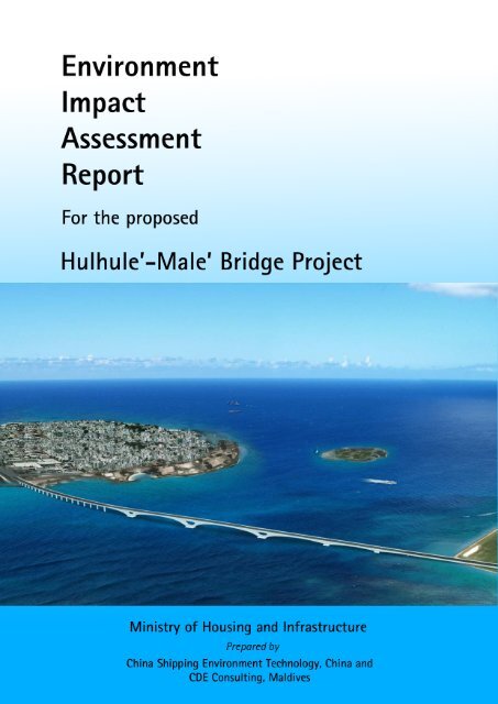
The project involves the construction and operation of a bridge linking Hulhule and Male’ Island<br />
across Gaadhoo Koa atoll pass. This is the first bridge of its kind in the Maldives. The total<br />
length of the proposed bridge is 2 km; the section of the bridge that covers the overwater area<br />
across Gaadhoo Koa channel is 1.39 km. The elevation of the bridge is 20 m. The width of the<br />
bridge is 20 m and there will be four lanes and pedestrian/bicycle lanes. The bridge landing area<br />
on Malé side is next to the Tsunami Monument and onto the Boduthakurufaanu Magu. The<br />
landing area on Hulhule’ is on the southern tip of Hulhule Island. The landing area that connects<br />
with Hulhule needs some land reclamation and shore protection. The source of sand for<br />
reclamation is a proposed harbour at Gulhifalhu Island. The duration of the proposed project is<br />
two years. The projects sites cover the bridge landing areas on the SE corner of Male’ (next to<br />
Tsunami monument), bridge approach located on the reef slopes of Male’ and the bridge main<br />
span located in the deep waters of Gaadhoo Koa. In addition, there will be a casting yard in<br />
Hulhumale’, a worksite in Hulhule and a worksite in Male’ located in “Adi Park”. The project is<br />
expected to employ about 480 persons of which specialist foreign labour will consist of 120<br />
persons and the rest are expected to be sourced from local workforce.<br />
The main rationale for the Hulhule-Malé Bridge is to increase the social development and<br />
economic opportunities in the Malé urban area. One of the biggest bottlenecks to the full<br />
utilization of Malé-Hulhule-Hulhumale as contiguous unit is the absence of land links. The<br />
bridge will link both the airport and Hulhumale’ to Malé and is part of a broader masterplan to<br />
link all the islands within Malé Urban Region spanning from Hulhumale’ to Thilafushi. The<br />
objective of this project is to develop the Malé and Hulhule section of the overall link.<br />
All project activities will be in conformance to the laws and regulations of the Maldives, and<br />
relevant international conventions that Maldives is party to. The key laws and regulations<br />
applicable to this project are Environmental Protection and Preservation Act, The Civil Aviation<br />
Act 2001, Decentralization Act, General Laws Act 4/68 and Law on Cultural and Historical<br />
Places 27/79. The key regulations applicable to this project are , Environmental Impact<br />
Assessment (EIA) Regulation 2012, Civil Aviation Regulations, Sand and Coral Mining<br />
Regulation, Regulation on Dredging and Reclamation, Regulation on cutting down trees,<br />
Dewatering Regulation, Waste Management Regulation 2013 and Regulation on Environmental<br />
Damage Liabilities 2011/R-9. This EIA is prepared based on the EIA Regulation 2012.<br />
Prepared by: CDE Consulting & China Shipping Environment Technology<br />
Page|xix
EIA for the proposed Hulhule-Male’ Bridge Project<br />
Existing environment of the proposed bridge sites and its surroundings were assessed. The<br />
proposed site for the project is Gaadhoo Koa. On Male’ side, the structure utilises the gentle reef<br />
slope on the SE corner of Male’ to construct the bridge approach. The main pillars are located at<br />
40 m depth on the channel bottom and the approach for Hulhule is partially on the Hulhule reef<br />
slope. The channel experiences strong tidal flow and receives strong swells from the SE<br />
direction. In particular, the wave conditions on the SE reef corner of Malé and on the southern<br />
tip of Hulhule Island are particularly strong. These hydrological conditions may hamper the<br />
project activities. The ecological condition of the reef around the proposed site is poor.<br />
However, there is a prominent dive site – the Maldives Victory - within close proximity to the<br />
site. The coastal areas around both Hulhule and Malé island is protected using shore protection<br />
measures and therefore impacts on coastal environment and erosion is non-existent. The<br />
proposed bridge passes over Raalhugandu, a prominent surfing spot in Malé. Gaadhoo Koa is at<br />
present is the main shipping lane for Malé port but will have to be closed down permanently.<br />
The proposed worksites at Hulhumale’ and Hulhule are barren land which were recently<br />
reclaimed. The sites on Malé will occupy land presently used for recreation. Traffic flow at the<br />
proposed site is very high and road closure is imminent. Traffic will have to be diverted. The<br />
proposed landing area on the southern tip of Hulhumale’ will interfere with flight path and<br />
therefore will have the work times restricted<br />
The negative physical impacts during the construction stage of this project are limited to the<br />
immediate vicinity of the project site and work sites. These include impacts on groundwater<br />
quality due to potential contamination; impacts on marine water quality due to drilling,<br />
reclamation, dredging, accidental oil or chemical spills, sewage, waste dumping and anchoring;<br />
vegetation loss on Malé site, impacts on marine ecology due to drilling, dredging, reclamation,<br />
shore protection, anchoring, self-lifting platform spuds; potential impacts on reef slope geology<br />
due to vibrations and drilling; hydrodynamic changes in relation to tidal flow and wave height<br />
changes; and noise, dust and vibration impacts around Malé landing site and Hulhumale’ work<br />
sites. Socio economic negative impacts include significant impacts on marine traffic which<br />
would be blocked off for the entire construction period; impacts on the surfing activities during<br />
construction; impacts on recreational activities at Adi Park; land traffic disruption; disruptions to<br />
airport activities; social impacts associated with a having large foreign workforce and impacts<br />
on visual amenity.<br />
Negative impacts during operation stage include loss of livelihood for ferry operators; increased<br />
accidents due to speeding, traffic congestion in Male’ due to presence of more vehicles arriving<br />
from Hulhumale’; rapid increase in traffic in Hulhumale’ which at present enjoys limited traffic;<br />
potential effects on surfing activities; parking challenges at airport, effects of surface runoff on<br />
marine water quality due to contaminants on the road surface; noise impacts around Male’<br />
Prepared by: CDE Consulting & China Shipping Environment Technology<br />
Page|xx
EIA for the proposed Hulhule-Male’ Bridge Project<br />
landing area, increased cost of airport transfer if the ferry services are ceased; impacts of shading<br />
from bridge on marine ecology; and, potential marine accidents with the bridge piers.<br />
The project mainly has positive socio-economic benefits, including increased direct and indirect<br />
job opportunities, growth of Hulhumale’ as an extension of Male’, ease of transport, tourism<br />
growth in Hulhumale’ and availability of better housing options.<br />
A number of mitigation measures are proposed for the most significant impacts from the project.<br />
These include reuse of dreg removed from the drilling activities for backfilling in Thilafushi,<br />
proper management of sewage, relocating trees within the project foot print, limiting working<br />
hours around bring landing site in Male’, planned rerouting of traffic, proper management and<br />
disposal of drilling fluids, installing anti-collision measures for marine traffic, measure to<br />
prevent marine and ground water pollution, measures to prevent sedimentation during dredging<br />
and reclamation, and measures to minimise impacts on social activities within the project foot<br />
print.<br />
Alternatives options were evaluated for the activities that are identified to have significant<br />
impacts on or from the project. The “no project” option was found to be viable for this project<br />
based on economic and social grounds as there are numerous other national level social and<br />
economic priorities. However, the “no project” option was found to be not viable in political<br />
terms as the proposed bridge is a key election promise of the present Government and the<br />
negotiations with the Chinese Government is far advanced. Additional alternatives evaluated<br />
include the choice of bridge location, bridge design scheme, foundation designs, dredging<br />
options, work site locations and scheduling. Among these, given the high impact on recreational<br />
activities in Adi park area, an alternative site with the same land area as the original plan is<br />
recommended within Adi Park area. Alternative dredging sites may have to be considered in a<br />
future addendum to this report.<br />
Stakeholders covering relevant government agencies, civil society and economic entities were<br />
consulted and their concerns are included in the report and recommended for the eventual<br />
implementation. In addition, a public opinion survey covering 847 respondents was conducted at<br />
the ferry terminal and within Male’. In general, there was an overwhelming positive response<br />
towards the project. The concerns of the Government agencies were similar focusing on bridge<br />
design parameters (such as bridge width, elevation, appearance and location), functionality (eg.<br />
how it fits within the broader master plan and traffic flow requirements), jurisdictional issues,<br />
and impacts on Male’ traffic. Some serious specific concerns were raised by some economic<br />
entities such as the communications service providers who will incur a significant cost to<br />
relocate their main manhole connecting the submarine fibre optic cables which support most of<br />
the communications of Male’. The manhole is located right below the bridge landing area and<br />
any shifting will involve significant disruption to communications in Maldives, specifically<br />
Prepared by: CDE Consulting & China Shipping Environment Technology<br />
Page|xxi
EIA for the proposed Hulhule-Male’ Bridge Project<br />
because the two service providers have their cables landing a the proposed bridge site. Concerns<br />
also exist with Maldives Ports Authority regarding closure of Gaadhoo Koa, but they have<br />
already been preparing for the change. Civil Aviation raised concerns about the bridge elevation,<br />
equipment elevation during construction, lighting during construction and operation and the<br />
significant time restrictions imposed when working closer to the airport. Among civic society the<br />
surfers have serious concerns regarding the potential unuseability of the surfing area,<br />
Raalhugandu, due to closure during construction and due to potential changes in wave conditions<br />
following pier construction. Public using the Adi Park area were concerned that the most heavily<br />
used areas are currently planned to be used as a work site in Male ‘during construction. They<br />
recommended changing the orientation to avoid the main areas of use. This change has been<br />
recommended in the alternatives section.<br />
Monitoring plan is designed to assess significant impacts on key areas such as marine water<br />
quality, noise, groundwater quality, air quality, waste management, marine pollution, social<br />
changes and impacts on reef environment. The management plan for this project is designed to<br />
produce a framework for anticipated impacts, including practicable and achievable performance<br />
requirements and systems for monitoring, reporting and implementing corrective actions. In<br />
addition provide evidence of compliance to legislation, policies, guidelines and requirements of<br />
relevant authorities.<br />
As the project has limited major adverse environmental impacts and relatively high socio<br />
economic benefits, the project should be carried out as proposed and with the mitigation<br />
measures and alternatives suggested in this report.<br />
Prepared by: CDE Consulting & China Shipping Environment Technology<br />
Page|xxii
EIA for the proposed Hulhule-Male’ Bridge Project<br />
ސާދާ ޚުލާސާ<br />
މި ރިޕޯޓަކީ ހުޅުލެއާއި މާލެ އާއި ދެމެދު<br />
ޕްލޭ ްނ އެޅުމަށް<br />
ކުރެވެމުންދާ ބްރިޖް<br />
އިމާރާތްކުރުމުގައާއި ހިންގުމުގައި<br />
ތިމާވެއްޓަ ްށ<br />
ކޮށްފާނެ އަސަރު ވަޒަންކުރުމުގެ ގޮތުން<br />
ތައްޔާރުކުރެވިފައިވާ އީ.އައި.އޭ ރިޕޯޓެވެ.<br />
މިމަޝްރޫޢުގެ އެދިޔާރަކީ<br />
މިނިސްޓްރީ އޮފް<br />
ހައުސިންގ އެންޑް އިންފްރާސްޓަރަކްޗަރެވެ.<br />
މިރިޕޯޓުގެ މައިގަނޑު ބޭނުމަކީ މަޝްރޫޢު ހިންގުމަށްޓަކައި ބޭނުންވާ ތިމާވެށީ ެގ<br />
ހުއްދައަށް ބޭނުންވާ މައުލޫމާތުތައް އެންވަޔަރަމެންޓް ޕްރޮޓެކްޝަން އެޖެންސީއަށް ހުށަހެޅުމެވެ.<br />
މިރިޕޯޓް ތައްޔާރުކޮށްފައި މިވަނީ<br />
ޗައިނާ ޝިޕިން އެންވަޔަރަންމަނޓް ޓެކްނޮލޮޖީ<br />
(ޗައިނާ)<br />
އަދި ސީ.ޑީ.އީ<br />
ކޮންސަލްޓިންގް<br />
(ދިވެހިރާއްޖެ) އިންނެވެ.<br />
މިމަޝްރޫޢުގައި މައިގަނޑު ގޮތެއްގައި ހިމެނެނީ މާލެއާއި ހުޅުލެއާއި ދެމެދު ގާދޫ ކޯ ހުރަސްކޮށް ބްރިޖެއް<br />
އެޅުމެވެ. މި ބްރިޖްގެ<br />
ސަބަބުން<br />
މާލެ އާއި ހުޅުލެ އަދި ހުޅުމާލެ އެއްގަމު މަގުން ގުޅާލެވޭނެއެވެ. މިއީ ރާއްޖޭގައި އިމާރާތްކުރެވޭ މިފަދަ ފުރަތަމަ<br />
ބްރިޖެވެ. މުޅި ބްރިޖުގެ އެއްގަމު މަގުތަކާއެކު ޖުމްލަ 2<br />
ކިލޯމީޓަރ ހިމެނޭނެއެވެ. މީގެ ތެރެއިން ގާދޫ ކޯ ހުރަސް ކުރާ<br />
20<br />
20<br />
ސަރަހައްދުގައި ހިމެނޭނީ 1.39<br />
ކިލޯމީޓަރެވެ. ބްރިޖްގެ އުސްމިނަކީ<br />
މީޓަރެވެ.<br />
ބްރިޖުގެ ފުޅާ މިނަކީ<br />
މީޓަރެވެ.<br />
ބްރިޖުގައި 4<br />
ލޭނާއި ހިނގާ/ބައިސްކަލް ދުއްވާ ދެ ލޭން ހިމެނޭނެއެވެ.<br />
މާލޭ ފަޅިން ބްރިޖް އެއްގަމާ ގުޅޭނީ ސުނާމީ ބިނާ<br />
ކައިރިން ބޮޑު ތަކުރުފާނު މަގަށެވެ. ހުޅުލޭ ކޮޅުން ގުޅޭނީ ހުޅުލޭ ދެކުނު ކޮޅަށެވެ. ހުޅުލެއާއި ގުޅުމަށް ފަރުން ތަންކޮޅެއް ހިއްކައި<br />
ތޮށި ލާން ޖެހެއެވެ.<br />
މިމަސައްކަތައް ވެލި ގެންނާނީ ގުޅިފަޅުންނެވެ.<br />
މަޝްރޫޢުގެ މަސައްކަތް ހިނގާނީ މާލޭގެ އިރު ދެކުނު<br />
ކަނުގަޔާއި، މާލޭ އިރުދެކުނު ފަރު މަތިން އަދި ގާދޫ ކޮލުގެ ފުން ސަރަހައްދުތަކާއި ހުޅުލޭ ދެކުނު ކޮޅުގައެވެ. މީގެ އިތުރުން<br />
މަޝްރޫޢުގެ ކާސްޓިންގ ޔާޑް ހުޅުމާލެއިން އަލަށް<br />
ހިއްކި ބިމުގައި އެޅުމަށާއި، ހުޅުމާލޭ ހުޅަނގު ދެކުނުކޮޅުގައި އަލަށް<br />
ހިއްކާފާއިވާ ބިމުގައި މަސައްކަތު ސައިޓެއް އެޅުމަށާއި މާލޭގެ "އަޑި ޕާކު"ގައި ސައިޓެއް އެޅުމަށް ވަނީ ޕްލޭން ކުރެވިފައެވެ.<br />
މާލެ އާއި ހުޅުލެއާއި ދެމެދު ބްރިޖެއް އެޅުމުގެ މައިގަނޑު މަޤްސަދަކީ މާލޭ އަރބަން ސަރަހައްދަށް އިތުރު އިޖްތިމާޢީ އަދި<br />
އިގްތިސާދީ ތަރައްޤީ ގެނައުމެވެ. ހުޅުމާލެއަކީ މާލެއަށް ދިމާވެފައިވާ ތޮއްޖެހުން ކުޑަކުރުމަށް ޕްލޭން ކުރެވިފައިވާ ރަށަކަށް<br />
ވީނަމަވެސް އެރަށަށް އަންނަންޖެހޭ ފުރިހަމަ ކުރިއެރިން ނައިސް ލަސްވާ އެއް ސަބަބަކީ މާލެއާއި<br />
އެއްގަމު މަގުން ގުޅިފައި<br />
ނެތުން ކަމުގައި ވަނީ ބެލެވިފައެވެ. މިމަޝްރޫޢަކީ މާލޭ އާބަން ސަރަޙައްދުގައި ހިމެނޭ ހުރިހާ ރަށެއް (ހުޅުމާލެއިން ފެށިގެން<br />
ތިލަފުށްޓާ ހަމައަށް) ގުޅާލުމަށް ތައްޔާރު ކުރެވިފައިވާ މާސްޓަރ ޕްލޭންގެ ދަށުން ކުރިއަށް ގެންދޭ ހަމައެކަނި މާލެ-ހުޅުލެ ގުޅާ<br />
ލުމުގެ ބައެވެ. މިހާތަނަށް ހަމައެކަނި ގުޅާލެވިފައިވަނީ ހުޅުލެއާއި ހުޅުމާލެއެވެ.<br />
މިރިޕޯޓް ކަމާއި ބެހޭ އިދާރާތަކުން ފާސްކޮށް ހުއްދަލިބުމާއިއެކު މަސައްކަތަށް ބޭނުންވާ ތަކެއްޗާއި ސާމާނު އަދި<br />
ސްޕެޝަލިސްޓް<br />
މަސައްކަތު<br />
މީހުން<br />
ރާއްޖެ ގެނެވޭނެއެވެ. މިމަޝްރޫއުއަށް ހިނގާނެކަމަށް ލަފާކުރެވިފައިވާ މުއްދަތަކީ<br />
ދެ އަހަރު ދުވަހެވެ.<br />
Prepared by: CDE Consulting & China Shipping Environment Technology<br />
Page|xxiii
EIA for the proposed Hulhule-Male’ Bridge Project<br />
120<br />
މިމަޝްރޫޢަށް ޖުމްލަ 480<br />
މީހުން ބޭނުން ވާނޭ ކަމަށް އަންދާޒާ ކުރެވެއެވެ. މީގެ ތެރެއިން<br />
މީހުންނަކީ ޗައިނާއިން ގެންނަ<br />
ސްޕެޝަލިސްޓުންނެވެ. އަދި ރާއްޖެއިން ބާކީ އެހެން މަސައްކަތްތެރިން ހޯދަން ޖެހޭނެކަމަށް ވަނީ އަންދާޒާ ކުރެވިފައެވެ.<br />
މިމަޝްރޫގެ ބައިތައް ރާއްޖޭގެ ގާނޫނާއި ގަވާއިދަށާއި މިހާރުގެ ސަރުކާރުގެ ސިޔާސަތުތަކަށް<br />
ފެތެއެވެ.<br />
މީގެ އިތުރުން މަސައްކަތް<br />
ފެށުގުމުގެ ކުރިން ނަގަން ޖެހޭ ހުއްދަތަކަކާއި އަންގަންޖެހޭ ފަރާތްތަކެއް ހިމެނެއެވެ. އެހުއްދަތައް މިރިޕޯޓްގައި<br />
2012<br />
ފާހަގަކުރެވިފައިވާނެއެވެ.<br />
މިރިޕޯޓް ތައްޔާރު ކުރެވިފައި މިވަނީ އީ.އައި.އޭ ހެދުމުގެ ގަވާއިދު<br />
މައްޗަށް ބިނާކޮށެވެ.<br />
މިދިރާސާގައި މިސަރަހައްދުގެ<br />
ހާލަތަށް ބަލާލެވިފައިވާނެއެވެ.<br />
މާލޭ ފަޅީން ބްރިޖެ އެޅުމަށް ހަމަޖެހިފައިވާ<br />
ސަރަހައްދުގެ<br />
އެއްގަމުގައި މިހާރު<br />
ހުރީ ބޮޑު ތަކުރުފާނު މަގެވެ. މިސަހައްދާޖެހިން ސުނާމީ ބިނާއާއި ޕާކެއް ހިމެނެއެވެ. ސުނާމީ ބިނާ<br />
މިސަރަހައްދުން އެހެން ތަނަކަށް ބަދަލު ކުރުމަށް ހައުސިންގ މިނިސްޓްރީއިން ވަނީ ނިންމަވާފައެވެ. ޖެހިގެން ހުރިޕާކުގައި ހުރީ<br />
މުޅިންވެސް<br />
އިންދާފައި ހުރި ގަސްތަކެވެ. މަސައްކަތުގެ ސަބަބުން ބައެއް ގަސް އެހެން ތަނަކަށް ބަދަލު ކުރަން ޖެހޭނެއެވެ.<br />
ބްރިޖެ އެޕްރޯޗްބައި އެޅުމަށް ހަމަޖެހިފައިބަނީ މާލޭ އިރު ދެކުނުފަރާތުގައި ތިލަކޮށް އޮތް ފަރުގައެވެ. މިސަރަހައްދުގެ ފަރުގެ<br />
45<br />
ދިރުން ވަރަށް ދަށެވެ.<br />
ބްރިޖުގެ<br />
މައިގަނޑު ބައި އެޅުމަށް ހަމަޖެހިފައިވަނީ ގާދޫ ކޮލުގެ<br />
މީޓަރު ފުން ސަރަހައްދެއްގައެވެ.<br />
މިސަރަހައްދުގައި މުޅިން ހިމެނެނީ ވެއްޔެވެ. ގާދޫ ކޮލަކީ ވަރަށް ބާރު އޮޔެއް އަޅާ ކަނޑުއޮޅިއެކެވެ. އަދި މާލޭ އިރުދެކުނު<br />
ކަންމައްޗާއި ހުޅުލޭ ދެކުނު ކޮޅަކީ ވަރަށް ބޮޑެތި ރާޅުނަގާ ސަރަހައްދެކެވެ. މިކަމުގެ ސަބަބުން މަޝްރޫގެ މަސައްކަތްތަކަށް ބު ޫރ<br />
އެރުމަކީ އެކަށީގެންވާ ކަމެކެވެ. ހުޅުލޭ ފަޅީގެ ވެސް ފަރުގެ ހާލަތު ދަށެވެ. ނަމަވެސް މާލެއަތޮޅުގެ އެންމެ މުހިން އެއް ޑައިވް<br />
ސައިޓްކަމަށްވާ "މޯލްޑީވްސް ވިކްޓަރީ" އޮންނަނީ ބްރިޖް އެޅުމަށް ހަމަޖެހިފައިވާ ސަރަހައްދާއި ކައިރީގައެވެ. މާލޭ ކޮޅުން ބްރި ްޖ<br />
ފަށާ ސަރަހައްދަކީ ރާޅާ އެޅުމަށް މުހިން "ރާޅުނަޑު ސަރަހައްދު" ފެށޭ ހިސާބެވެ. އަދި ގާދޫ ކޮލަކީ މާލޭ ކޮމާޝަލް ބަނދަރަށް<br />
ބަނދަރު ކުރާ ގިނަ ބޯޓު ފަހަރު ދަތުރު ކުރާ މަގެވެ. މިމަޝްރޫއާއި ގުޅިގެން ބޯޓުތައް<br />
ދެން ދަތުރުކުރާނީ ބޮޑު ކަޅިންނެވެ.<br />
ހުޅުލޭ ދެކުނުކޮޅުގައި މަސައްކަތް ކުރާ ސަރަހައްދަކީ މިހާރު ގެ ރަންވޭގެ ފްލައިޓް ޕާތެވެ. ވީމާ މަސައްކަތް ކުރެވޭ ވަގުތުތަށް<br />
ވަރަށް ބޮޑަށް ކޮންޓްރޯލް ކުރެވޭނެއެވެ. ރަންވޭ އެހެން ދިމާލަކަށް ބަދަލު ކުރުމުގެ މަޝްރޫއެއް ވަރަށް<br />
އަވަހަށް ފަށަން<br />
ހަމެޖެހިފައިވާކަމަށް އެއަޕޯޓް ކޮމްޕެނީ އިން ވަނީ މަޢުލޫމާތު ދެއްވާފައެވެ. މާލޭގެ މަސައްކަތު ސައިޓް އެޅުމަށް ހުށަހަޅާފައިވާ<br />
ސަރަހައްދަކީ މިހާރު ގިނަބަޔަކު ކުޅިވަރު ކުޅުމަށާއި ކަސްރަތު ކުރުމަށް ބޭނުން ކުރާ ތަނެކެވެ.<br />
ހުޅުމާލޭއާއި ހުޅެލޭގެ ސައިޓަކީ<br />
ވަރަށް ފަހުން ހިއްކާފައިވާ ހުސްބިންތަކެވެ.<br />
މަޝްރޫއަށް ވެލިނެގުމަށް ހުށަހެޅިފައިވާ ގުޅިފަޅަކީ މިހާރުވެސް ކޮނުމާއި ހިއްކުމުގެ<br />
މަސައްކަތް ކުރަމުންދާ ތަނެކެވެ.<br />
މިދިރާސާއިން ފާހަގަކުރެވުނުގޮތުގައި މިމަޝްރޫއުގެ ސަބަބުން އަމަލީ މަސައްކަތުގެ މަރުހަލާގައި<br />
ތިމާވެއްޓަށް ކޮށްފާނެ ނޭދެ ޭވ<br />
އަސަރުތަށް<br />
ބޮޑަށް ކުރާނީ މަޝްރޫޢު ހިންގާ ސަރަހައްދާއި މަސައްކަތު ސައިޓްތަކުގައެވެ.<br />
މީގެ ތެރޭގައި ރަށުގެ ފެންފަށަލައަށް<br />
ތަޣައްޔަރު<br />
ވުމާއި، މޫދުގެ ލޮނުގަނޑަށް ޕައިލް އެޅުމަށް ތޮރުފުމާ ިއ، ބި ން ހިއްކު މާއި. ކޮނުމާއި، ތޮށި ލުމާއި،<br />
ކުނިއެޅުމާއި ތެޔޮ<br />
އެޅުމާއި ނަގިސް ފެން ދިއުމުގެ<br />
ސަބަބުން އަސަރު ކުރުމާއި، ގަސް<br />
މަދުވުމާއި، ފަރަށް ގެއްލުން ވުމާއި، އަޑު ގަދަވުމުގެ<br />
Prepared by: CDE Consulting & China Shipping Environment Technology<br />
Page|xxiv
EIA for the proposed Hulhule-Male’ Bridge Project<br />
ސަބަބުން އާންމުންނަށް އުނދަގޫ ވުމާއި، އޮއިވަރަށާއި<br />
ރާޅުގަނޑަށް ބައެއް ބަދަލު އައުން ފަދަ ކަންތައް ހިމެނެއެވެ. މީގެ<br />
އިތުރުން އިޖްތިމާއީ އަދި އިގް ިތސާދި ގޮތުން ކުރާ ނޭދެވޭ އަސަރުތަކުގެ ތެރޭގައި ބޮޑެތި ބޯޓް ފަހަރަށް ގާދޫ ކޯ ބޭނު ްނ<br />
ނުކުރެވުމާއި، އިމާރާތް ކުރާ<br />
މުއްދަތުގެ<br />
ތެރޭގައި އެއްވެސް އުޅަނދަކަށް ގާދޫ ކޯ ބޭނުން ނުކުރެވުމާއި،<br />
ރާޅުގަނޑު ސަރަހައްދު<br />
ބައެއް ހާލަތްތަކުގައި ސޭފްޓީއަށް ޓަކައި ބޭނުން ނުކުރެވުމާއި، އަޑި ޕާކް ބޭނުންކުރާ އެތައް ބަޔަކަށް އަސަރު ކުރުމާއި އަދި<br />
ރާއްޖެއިން ބޭރުން ގިނައަދަދެއްގެ ބޭރުމީހުން މާލެއާއި ހުޅުމާލެއަށް އައުމުން ދިމާވެދާނެ އިޖްތިމާއީ ހަމަނުޖެހުން ހިމެނެއެވެ.<br />
ބްރިޖް އިމާރާތް ކުރުމަށްފަހު ހިންގުމުގައި ދިމާވެދާނެ ނޭދެވޭ އަސަރުތަކުގެ ތެރޭގައި ފެރީ އޮޕަރޭޓް ކުރާފަރާތްތަށް ދިމާވެދާ ެނ<br />
މާލީ ގެއްލުން ތަކާއި، އެކްސިޑެންޓްތައް ގިނަވުމާއި، މާލެ އަދި ހުޅުމާލޭގެ ޓްރެފިކް އިތުރަށް ތޮށް ޖެހުމާއި، ރާޅާ އެޅުމުގެ<br />
ކުޅިވަރަށް ފަހަރުގައި ނޭދެވޭ އަސަރު ކުރުމާއި، ހުޅުލޭގައި ޕާކިން<br />
މައްސަލަ ނިކުތުމާއި، ވިއްސާރަވެހުމުން ބްރިޖް މަތީގައިވާ<br />
ތަޢައްޔަރުވެފައިވާ ފެން މޫދަށް ފޭބުމުން ކަނޑުގެ ލޮނުގަނޑުގެ ކޮލިޓީއަށް އަސަރު ކުރުމާއި،<br />
މި ސަރަހައްދުތަކަށް<br />
އަޑުގަދަވުމާއި، އެއަރޕޯޓަށް ދަތުރު ކުރުމުގެ ޚަރަދު ބޮޑުވުމާއި، ބްރިޖްގެ ހިޔާއެޅުމުގެ ސަބަބުން ކަނޑުގެ ދިރުމަށް<br />
އަސަރުކުރުމާއި ކަނޑުމަތީގެ އެކސިޑެންޓްތައް އިތުރުވެގެން ދިއުން ހިމެނެއެވެ.<br />
މިމަޝްރޫޢުގެ ސަބަބުން މައިގަނޑު ގޮތެއްގައި ހުރީ އިޖްތިމާއި އަދި އިގްތިސާދީ ފައިދާ ތަކެވެ. މިގޮތުން ވަޒީފާގެ ފުރުސަތު<br />
ބްރިޖް މަޝްރޫޢުއިން ތަނަވަސް ވުމާއި ބްރިޖް އެޅުމާއި ގުޅިގެން އިތުރު ވަޒީފާ އުފެދުމާއި، ހުޅުމާލެ އިގްތިސާދީ ގޮތުން<br />
ހަލުއިކޮށް ތަރައްގީވުމަށް މަގުފަހި ވުމާއި، ދަތުރުފަތުރުގެ ޚަރަދު ކުޑަވުމާއި މާލެ ތޮއްޖެހުން ކުޑަވުމަށް ބައެއް ފުރުސަތުތަށް<br />
ހުޅުވިގެން ދިއުން ހިމެނެއެވެ.<br />
މަޝްރޫޢުއިން ދިމާވެދާނެ ނޭދެވޭ އަސަރުތަށް ކުޑަކުރުމަށް އެޅިދާނެ ފިޔަވަޅުތައް މިރިޕޯޓްގައި ބަޔާން ކުރެވިފައިވާނެއެވެ. މިގޮތުން<br />
ޕައިލް ކުރަން ކޮނުމުގެ ސަބަބުން އުފެދޭ ބާކީ ބައި ސަލާމަތްތެރި ކަމާއެކީ ތިލަފުށްޓަށް ގެންދިއުމުގެ އިންތިޒާމް ހަމަޖެއްސުމާއި،<br />
މަސައްކަތު މީހުން ތިބޭ ސައިޓް ތަކުގެ ނަޖިސް ފެން ހިންދާނޭ ރަނގަޅު ނިޒާމެއް ގާއިމު ކުރުމާއި، ބޮޑެތިގަސްތައް އެހެ ްނ<br />
ސަރަހައްދަކަށް ބަދަލު ކުރުމާއި،<br />
ޓްރެފިކް ރަނގަޅަށް މެނޭޖް ކުރުމާއި، ކަނޑު މަތީގެ ހާދިސާތައް މަދުކުރުމަށް ބްރިޖް ވަށައިގެ ްނ<br />
މެރިން ސޭފްޓި ވަރުގަދަ ކުރުމާއި، ފެން ފަށަލައަށާއި މޫދު<br />
ލޮނުގަނޑަށް ނޭދޭވޭ އަސަރު ކުރުން މަދުކުރުމަށް ފިޔަވަޅު އެޅުމާއި<br />
އިޖްތިމާއީ ގޮތުން ލިބިދާނެ ގެއްލުންތައް ކުޑަކުރުން ހިމެނެއެވެ.<br />
މިމަޝްޜޫޢޫގެ ބައިތަކަށް ގެނެވިދާނެ ބައެއް ބަދަލުތަކަށް ބަލާލެވިފައިވާނެއެވެ. މިގޮތުން މި ޕްރޮޖެކްޓް ނުހިންގުމާއި، ބްރިޖް<br />
ޑިޒައިން<br />
ކުރެވިދާނޭ އިތިރު ގޮތްތަކާއި، ފައުންޑޭޝަން އެޅިދާނޭ އިތުރުގޮތްތަކާއި، ބްރިޖް އެޅިދާނޭ އިތުރު ދިމާތަކާއި،<br />
މަސައްކަތު ސައިޓްތައް އެޅިދާނޭ އެހެން ތަންތަނާއި ޝެޑިއުލަށް ގެނެވިދާނޭ ބައެއް ބަދަލުތަކަށް ބަލާލެވިފައިވާނެއެވެ. މީގެ<br />
ތެރެއިން ބަދަލު ކުރުމަށް ލަފާދީފައިވަނީ މާލޭގެ މަސައްކަތު ސައިޓަށް އެކަންޏެވެ. އެއީ ރ މިހާ ު<br />
ހުށަހެޅިފައިވާ ގޮތަށް ބި ްނ<br />
Prepared by: CDE Consulting & China Shipping Environment Technology<br />
Page|xxv
EIA for the proposed Hulhule-Male’ Bridge Project<br />
ނަގައިފިނަމަ<br />
މިސަރަހައްދުގައި ކުޅިވަރު ކުޅުމަށް ބޭނުން ކުރާ އެތައް ބަޔަކަށް އުނދާގޫ ވުމާއި އެބިން ސައިޒަށް އިތުރު ބަދަލެއް<br />
ނުގެނެސް ކުޅިވަރު ކުޅޭ މީހުންނަށް އުނދަގޫ ނުވާ<br />
ނޭ ގޮތަކަށް ނެގެން އޮތުމުންނެވެ.<br />
މިރިޕޯޓުގައި ބަޔާންކޮށްފައިވާ ތިމާވެއްޓަށް<br />
އަސަރުކުރާމިންވަރު ދެނެގަތުމަށާއި އެފަދަ ކަމަކުން ލިބިދާނެ ގެއްލުން ކުޑަކުރުމަށާ ިއ<br />
އަދި މި ރިޕޯޓުގައި ބަޔާންކުރެވިފައިނެތް ކަމެއް ކުރިމަތިވެއްޖެ ހާލަތެއްގައި އެކަންކަން ދެނެގަތުމަށްޓަކައި މަޝްރޫއުގެ އެ ިކ<br />
މަރުހަލާތަކުގައި މިފަދަ ކަންކަމަށް ސްކްރީންކުރުމަށް ހަމަޖެހިފައިވެއެވެ. މިގޮތުން ބެލުމަށް ހަމަޖެހިފައިވާ މައިގަނޑު<br />
ކަންތައްތަކުގެ ތެރޭގައި<br />
ވަށައިގެންވާ ސަރަހައްދުގެ<br />
ފެންޓެސްޓްކޮށް އަންނަ<br />
ބަދަލުތައް ދެނެގަތުމާއި<br />
އިޖްތިމާޢީ ގޮތުން<br />
އަންނަ<br />
ބަދަލުތައް<br />
ފަދަ ކަންކަން<br />
ކަނޑައެޅިފައިވާ ވަކި މުއްދަތުތަކެއްގައި ބަލާ ދިރާސާކުރުން ހިމެނެއެވެ.<br />
މިދިރާސާގައި ކަމާބެހޭ ސަރުކާރުގެ އިދާރާތަކާއި<br />
އާންމު ރައްޔިތުންނާއި<br />
ބައްދަލުކޮށް ޚިޔާލު ބަދަލުކުރެވިފައިވާނެއެވެ. މިގޮތު ްނ<br />
24<br />
ސަރުކާރުގެ އިދާރާތަކާއި،<br />
މަދަނީ<br />
މުޖުތަމަޢުގެ ހިމެނޭގޮތަށް<br />
ފަރާތަކާ މަޝްވަރާ ކުރެވުނެވެ. މީގެ އިތުރުން އާންމު<br />
ރައްޔިތުންގެ 847<br />
ފަރާތަކާ އިންޓަވިއު ސަރވޭ އެއް ކުރެވުނެވެ. މިދިރާސާތަކުން ފެނުނުގޮތުގައި މިމަޝްރޫޢަށް ބޮޑު ތަރުހީބެއް<br />
އެބައޮތެވެ. ސަރުކާރުގެ ކަމާ ބެހޭ ފަރާތްތަކާއެކު ކުރެވުނު<br />
މަޝްވަރާތަކުގައި ގިނައިން ވާހަކަ ދެގެވުނީ ބްރިޖްގެ ޑިޒައިންގެ<br />
ބައިތަކާ ބެހޭގޮތުންނާއި، ބްރިޖް ބޭނުން ކުރުމާއި ބްރިޖާއި ގުޅިގެން ދިމާވެދާނެ ބައެއް ކަންކަމާ ބެހޭގޮތުންނެވެ. ނަމަވެސް ބައެއް<br />
ފަރާތްތަކުން މުހިންމު ބައެއް ކަންބޮޑުވުން ތައް ހުއްޓެވެ. މީގެ ތެރޭގައި އޫރިދޫ އަދި ދިރާގުގެ ކަނޑުއަޑިން ގުޅާލެވިފައިވަ ކޭބަ ްލ<br />
އެއްގަމާ ގުޅޭ މޭންހޯލް ބޭންދިފައި ވަނީ މިސަރަހައްދުގައި ކަމަށް ވުމުން މިތަން ބަދަލު ކުރުމުގެ ތެރޭގައި ރާއްޖޭގެ މުވާސަލާތީ<br />
30<br />
ޚިދްމަތްތަކަށް 14<br />
ނުވަތަ<br />
ދުވަސް ވަންދެން އަސަރުކުރުމާއި ބޮޑު ޚަރަދެއް ދިއުން ހިމެނެއެވެ. އަދި ސިވިލް އޭވިއޭޝަނުން<br />
ފާހަގަ ކުރެއްވިގޮތުގައި ބްރިޖްގެ<br />
އުސްމިނާއި، ލައިޓް ހަރުކުރެވޭގޮތާއި، ހުޅުލޭ ކައިރީގައި މަސައްކަތް ކުރާއިރު މަސައްކަތް<br />
ކުރާގަޑި ކޮންޓްރޯލް ކުރަންޖެހުމާއި، ބޭނުންކުރާ<br />
އިކުއިޕްމަންޓްތަކުގެ އުސްމިން ކޮންޓްރޯލްކުރަން ޖެހޭނޭކަމަށް ފާހަގަކުރެއްވިއެވެ.<br />
ޕޯޓްސް އޮތޯރިޓީއާއި ޓްރާންސްޕޯޓް އޮތޯރިޓީ އަދި ކޯސްޓްގާޑުން މެރީން ޓްރެފިކް ސެކިއުރިޓީއާއި ބެހޭގޮތުން ކުރަންޖެނޭ ބައެ ްއ<br />
ކަންކަން ފާހަގަކުރެއްވިއެވެ. މީގެ އިތުރުން ބްރިޖް އެޅުމުގަޔާއި އެޅުމުގެ ފަހުން މިސަރައްހައްދުގެ ރާޅުތަކަށް އަތުވެދާނެ<br />
ބަދަލަކާމެދު މިސަރަހައްދުގައި ރާޅާ އަޅާ ފަރާތަތްކުން ކަންބޮޑުވުން ފާޅު ކުރެއްވިއެވެ. އަދި އަޑި ޕާކް ބޭނުންކުރާ ފަރާތަތްކުން<br />
މާލޭ މަސައްކަތު ސައިޓް މިހާރު އެންމެ ބޭނުން ކުރާ ދަނޑުތައް ނަގަން ޖެހޭ ގޮތަށް ކުރަހާފައި ވާތީވެސް ކަންބޮޑުވުން ފާޅުކޮށް<br />
ސައިޓް ހަމަ އެބޮޑުމިނުގައި ނަމަވެސް ގިނަފަރާތްތަކަށް އުނދަގޫ ނުވާނެ ގޮތަކަށް ބޭއްވިދާނެ ގޮތްތަކެއް ފާހަގަ ކުރެއްވިއެވެ.<br />
މި މަޝްރޫއުގެ ސަބަބުން<br />
ސަރަހައްދުގެ ވެށްޓަށް<br />
ނޭދެވޭ<br />
އަތުވެދާނެ ކަމަށް ބެލެވެއެވެ.<br />
ނަމަވެސް މިރިޕޯޓްގައި ބަޔާންކޮށްފައިވާ<br />
މިޓިގޭޝްން މެޝަރސް ތަކާއި ބަދަލުގައި ކުރެވިދާނޭ ކަންކަމަށް ރިޔާކޮށް އަދި ތަފްސީލްކޮށް ވެއްޓަށް<br />
އަންނަމުންދާ ބަދަލުތަ ްށ<br />
ރަނގަލަށް ބެލިއްޖެނަމަ މިދެންނެވުނުފަދަ<br />
ބަދަލުތަކުގެ<br />
ނޭދެވޭ ކުރާ ސަބަބު ްނ<br />
އަސަރުތަށް<br />
ބޮޑަށް ވަރަށް<br />
ކުޑަކުރެވިދާނެއެވެ.<br />
މިމަޝްރޫއަކީ އިޖްތިމާއި އަދި އިގްތިސާދީ ގޮތުން ނުހަނު ފައިދާ ހުރި ޕްރޮޖެކްޓަކަށް ވާތީ އަދި ނޭދެވޭ އަދި އިޔާދާ ނުކުރެވޭ<br />
ވަރުގެ ބޮޑު ބަދަލެއް ތިމާވެށްޓަށް ނުކުރާތީވެ މިމަޝްރޫޢު ކުރިއަށް ގެންދިއުމަށް މިރިޕޯޓުން ލަފާދެއެވެ.<br />
Prepared by: CDE Consulting & China Shipping Environment Technology<br />
Page|xxvi
EIA for the proposed Hulhule-Male’ Bridge Project<br />
1 Introduction<br />
1.1 Purpose of the EIA<br />
This Environment Impact Assessment (EIA) report is an evaluation of the potential<br />
environmental impacts of the proposed Hulhule-Male’ Bridge Project. The project is proposed<br />
by Ministry of Housing and Infrastructure (MHI). The EIA consultant is China Shipping<br />
Environment Technology (Shanghai) Co. Ltd (CSET), China and CDE Consulting, Maldives.<br />
This document is submitted to EPA by the proponent to fulfil the requirements of Environmental<br />
Protection and Preservation Act (EPPA) of the Maldives (4/93), more specifically the clause 5 of<br />
the Act which states that a report should be submitted before implementation of any project that<br />
may have a potential impact on the environment. This document has been developed based on<br />
the Terms of Reference (Appendix A) issued by the Environmental Protection Agency (EPA) on<br />
10 June 2015.<br />
1.2 Project Proponent<br />
The proponent of this project is Ministry of Housing and Infrastructure.<br />
1.3 Project Scope<br />
The project involves the construction and operation of a bridge between Male’ and Hulhule<br />
Island. This bridge will be the first of its kind and will link Male’, Hulhule Airport and<br />
Hulhumale’ settlement.<br />
The main activities of the project are:<br />
1. Mobilization and work site setup (in Male’, Hulhule and Hulhumale’)<br />
2. Land reclamation and shore protection at Hulhumale’ landing site<br />
3. Construction of bridge landing area roads<br />
4. Construction of bridge approach and main sections<br />
5. Installation of auxiliary facilities<br />
6. Demonization<br />
7. Operation<br />
Prepared by: CDE Consulting & China Shipping Environment Technology<br />
Page|1
EIA for the proposed Hulhule-Male’ Bridge Project<br />
1.4 Project Rationale, Aim and Objectives<br />
The main rationale for the Hulhule-Male’ Bridge is to increase the social development and<br />
economic opportunities in the Male’ urban area. One of the biggest constraints to the full<br />
utilization of Male’-Hulhule-Hulhumale as contiguous unit is the absence of land links.<br />
This project will enable the linking of Male’ to Hulhule. It is critical to have a land link between<br />
the capital Male’ and the international airport that serves the capital. The international airport<br />
presently receives about three million international passengers and 796,333 domestic passengers<br />
every year. The planned airport expansion and redevelopment envisages arrival of over 5 million<br />
tourists to the Maldives every year.<br />
Hulhumale’ currently hosts a population of 30,000. By the end of phase II development,<br />
Hulhumale’ is expected to have a resident population of about 200,000. The bridge will allow<br />
for the full integration of the Hulhumale’ residential population as an integral part of the Male’<br />
urban area. The bridge will provide essential access to services such as schools, hospitals, sports,<br />
recreation and entertainment. The bridge will also facilitate daily commuting for employment<br />
and business purposes.<br />
The bridge development is envisaged to provide new and additional economic opportunities for<br />
businesses in the Male’ urban area and improve the economic competitiveness of the Maldives<br />
as a whole.<br />
The aim of this project is to link the two main settlements in Male Urban Region – Male’ and<br />
Hulhumale’. The project is part of an overall master plan to link all islands within the Male’<br />
Urban Region group.<br />
The object of this project is to build a bridge linking Hulhule and Male’ and subsequently to<br />
Hulhumale via the existing roads between Hulhule and Male’.<br />
1.5 Consultants, Contractors and Government Institutions<br />
All the EIA related work is undertaken by consultants from China Shipping Environment<br />
Technology (Shanghai) Co. Ltd (CSET), China and CDE Consulting, Maldives. The project<br />
engineer is CCCC Highway Consultants Co. Ltd, China.<br />
The project is executed by Ministry of Housing and Infrastructure<br />
1.6 Project Financing<br />
The project is to be financed with the assistance of Chinese Government, Chinese banks and<br />
Maldivian Government. The estimated project cost is between US$250-300 million. The<br />
Prepared by: CDE Consulting & China Shipping Environment Technology<br />
Page|2
EIA for the proposed Hulhule-Male’ Bridge Project<br />
Chinese Government is expected to provide US$100 million as grants and the Maldivian<br />
Government will contribute US$30 million. The rest are expected to be financed from Chinese<br />
Banks.<br />
1.7 Scope and Terms of Reference of EIA<br />
The scope of this EIA is broadly based on the Environmental Impact Assessment Regulations<br />
2012. The assessment more specifically adheres to the Terms of Reference (ToR) issued by the<br />
Environmental Protection Agency on 10 June 2015. The ToR is based on scoping meetings held<br />
between the stakeholders on 4 June 2015. A copy of the ToR is attached in Appendix A.<br />
The EIA report contains the following main aspects.<br />
A description of the project including the need for the project, how the project will be<br />
undertaken, full description of the relevant parts of the project, implementation schedules, site<br />
plans and summary of project inputs and outputs (Chapter 1&2).<br />
A description of the pertinent national and international legislation, regulations and policies that<br />
are relevant and applicable to the project and a demonstration of how the project conforms to<br />
these aspects (Chapter 3)<br />
Information on the baseline environmental condition of the project site; this includes information<br />
on terrestrial environment near the project site (Chapter 4).<br />
An assessment of the potential impacts during both construction and operational stages of the<br />
project and identification and cost of the potential mitigation measures to prevent or reduce<br />
significant negative impacts during both construction and operation stages of the project<br />
(Chapter 5 & 6).<br />
Assessment of alternatives for the proposed project (Chapter 7).<br />
Details of the environmental management and monitoring plan (Chapter 8 & 9).<br />
Stakeholder Consultations (Chapter 10)<br />
Potential gaps in information (Chapter 11)<br />
Main conclusions (Chapter 12)<br />
Prepared by: CDE Consulting & China Shipping Environment Technology<br />
Page|3
EIA for the proposed Hulhule-Male’ Bridge Project<br />
1.8 Assessment Methodology<br />
1.8.1 General Approach<br />
This EIA is broadly guided by the EIA Regulations 2012.<br />
This report has been prepared to ensure that the significant environmental and social impacts of<br />
the proposed project at the preconstruction, construction, operation and demobilising stages have<br />
been considered and assessed at the project planning phase.<br />
The process followed in the preparation of this EIA report consists of six parts. These are:<br />
scoping consultations; literature review; field surveys; stakeholder consultations; analysis of<br />
results; and compilation of the assessment in the form of a report.<br />
In order to conduct a broad based and inclusive study, the proponent and the consultant have<br />
from the onset ensured the exercise is participatory. As such, discussions have been held with<br />
community members in the projects area and relevant stakeholders with the assistance and<br />
coordination of the proponent.<br />
1.8.2 The Study Area<br />
The study area of this project considers that the reef pass, SE corner of Male’, Southern side<br />
Hulhule Island and the worksites will be physically affected by the development. In addition, it<br />
is assumed that socio-economic impacts will be primarily felt on the three islands (Male’,<br />
Hulhule and Hulhumale’ Island).<br />
Study area boundary is presented in Figure 1.1 and survey locations map for the project is<br />
attached in Appendix E.<br />
Prepared by: CDE Consulting & China Shipping Environment Technology<br />
Page|4
EIA for the proposed Hulhule-Male’ Bridge Project<br />
Figure 1.1: Study Area boundary<br />
1.8.3 Field Observations<br />
Field assessments were undertaken between April and June 2015. Field visits mainly covered<br />
marine environment, hydrology and areas on land where boreholes are to be drilled. In addition,<br />
stakeholder consultations were carried out with relevant agencies, specifically for this EIA.<br />
1.8.3.1 Oceanography<br />
Bathymetric data was collected by attaching an echo sounder system with a small motorized<br />
vessel and traversing the area following depth sounding principle. Secondary bathymetric data<br />
available on charts were also collected and reviewed.<br />
Currents were measures using drogue method. About 3 measurements were undertaken from<br />
every site and an average value is determined. Current measurements at the surface of lagoon<br />
and open sea were also measured using an AQUAlogger 520 current meter. The Wave/Current<br />
measurement is divided into six layers for assessment purposes. They are the surface, 0.2H,<br />
0.4H, 0.6H, 0.8H and bottom (see Figure 1.2).<br />
Prepared by: CDE Consulting & China Shipping Environment Technology<br />
Page|5
EIA for the proposed Hulhule-Male’ Bridge Project<br />
Figure 1.2: Schematic diagram of the measurement method<br />
Tide data has been taken from Male’ International Airport Tide Gauge.<br />
Wave patterns have been estimated using secondary studies and by installing a wave gauge<br />
(AWAC—AST) located at the project site near Male’ reef.<br />
1.8.3.2 Marine Assessments<br />
Visual Snorkelling Survey<br />
Visual snorkelling surveys were carried out at selected locations of the reef flat and the channel<br />
near Male’ and Hulhule’ island that falls within the footprint of the project, to qualitatively<br />
determine the main benthic composition and the general status of these areas. This method<br />
allows for a quick assessment of the survey areas.<br />
Photo Quadrat Survey<br />
A 50 m transect line was deployed along the reef slope at 10 m, 20 m, and 30 m depths at each<br />
island (Male’ and Hulhule’). A total of 10 high resolution photographs were taken every 5 m,<br />
along the transect lines (each photograph covers 0.5 m 2 area of the sea bed). These were later<br />
analysed using CPCe. CPCe, or Coral Point Count with excel extension, developed by the<br />
National Coral Reef Institute, is software designed to determine coral community coverage and<br />
diversity using transect photographs. Underwater photographic frames are overlaid by a matrix<br />
of randomly generated points, and the fauna/flora of species or substrate type lying beneath each<br />
point is identified. 20 random points per picture were analysed to characterize the substrate<br />
composition (sample size: 250 points per transect).<br />
Prepared by: CDE Consulting & China Shipping Environment Technology<br />
Page|6
EIA for the proposed Hulhule-Male’ Bridge Project<br />
Fish Census<br />
Fish and invertebrate species assemblages and abundance were surveyed using the same 50 m<br />
line transects deployed for the Photo Quadrat survey. An observer swam along the transect line<br />
and recorded the different species of fish and invertebrates observed within 2.5 m either side of<br />
the transect line. A category based method was adopted to estimate fish abundance and the mean<br />
number of fish per category and observation was extracted to estimate species and family<br />
abundance. The categories used to estimate abundance is displayed in<br />
Table 1.1: Fish abundance category<br />
Category Number of Fish<br />
1 1<br />
2 2 – 4<br />
3 5 – 16<br />
4 17 – 64<br />
5 65 – 256<br />
6 257 – 1024<br />
7 1025 - 4096<br />
In addition the following secondary data/ information were also obtained from the govt.<br />
departments:<br />
• Identification and evaluation of Marine Protected Areas/ Habitats in the vicinity)<br />
• Protected or endangered species within the study boundary<br />
• Identification and evaluation of key ecosystems (e.g. coral reefs, spawning sites for fish,<br />
nursery areas for crustaceans or specific sites for marine mammals, sharks and turtles)<br />
• Fish diversity, fish landing, fish breeding and migration<br />
• IUCN Red List species and any species of national conservation interest to Maldives<br />
• Types of endemic and restricted-ranged species<br />
• Type of migratory species, including offshore migratory marine animals<br />
1.8.3.3 Noise Measurement<br />
Sound pressure level measurements in decibels dB (A) (with a precision upto 1 decimal place)<br />
have been recorded continuously for 24 hours at 15 minutes interval using a calibrated noise<br />
meter with attached data logger to store the data. Moreover, at each of the selected sites<br />
monitoring was planned for two days to get a representative mean result. The data stored at the<br />
meter was transferred to the computer using compatible software. Equivalent noise levels for day<br />
(Leq day) and night (Leq night) were calculated considering data for 0700-2200 hrs. As day time<br />
and 2200-0700 hrs. as night time. The recorded decibels values were converted to equivalent day<br />
time and night time levels and compared with the levels specified at Guidelines for Community<br />
Noise, WHO 1999.<br />
Prepared by: CDE Consulting & China Shipping Environment Technology<br />
Page|7
EIA for the proposed Hulhule-Male’ Bridge Project<br />
The noise monitoring stations have been selected at receptor locations that are likely to be<br />
affected during construction and operational phases of the proposed project viz. due to operation<br />
of construction machineries and vehicular movement.<br />
1.8.3.4 Flora and Fauna<br />
Terrestrial flora of all three islands were surveyed by walking along the island following the line<br />
transect method. The types and abundance of species were recorded along the surveyed lines.<br />
Information on the occurrence of terrestrial fauna was obtained along the line transect.<br />
1.8.3.5 Marine Water Samples<br />
Water quality was assessed from MWSC laboratory. Water quality samples were taken at<br />
different locations selected based on proposed developments. Parameters measured include<br />
electrical conductivity, total dissolved solids (TDS), salinity, pH, temperature, Sulphate,<br />
Phosphate, Total Petroleum Hydrocarbon and biological oxygen demand (BoD). The laboratory<br />
uses methods prescribed in “Standard Methods for Examining Water and Wastewater”. Samples<br />
were collected in clean 1.5L PET bottles after washing them with the water to be sampled. Water<br />
samples were collected below 1 m from the surface. Biological samples were collected in<br />
sterilized 100 ml glass bottles provided by the MWSC Laboratory.<br />
1.8.3.6 Ground Water Samples<br />
Ground water samples were collected from three locations: Male’, Hulhule and Hulhumale’. In<br />
Male’ a well was dug to 1 m below water table and allowed to settle, before taking grab samples.<br />
In addition, water from the well at the nearest building – Marine Research Centre building – was<br />
also taken. Samples at Hulhule and Hulhumale’ were collected by digging a well 1 m below<br />
water level.<br />
Samples were collected in clean 1.5L PET bottles after washing them with the water to be<br />
sampled. Water samples were collected below 1 m from the surface. Biological samples were<br />
collected in sterilized 100 ml glass bottles provided by the Public Health Laboratory.<br />
1.8.4 Key Stakeholder Consultation<br />
During the EIA preparation for the bridge project, stakeholder consultations were conducted<br />
extensively. Stakeholder consultations were conducted between 15 th June and 5th July 2015. The<br />
following stakeholders were consulted for this EIA:<br />
1. Ministry of Housing and Infrastructure<br />
2. Hulhumale’ Development Corporation<br />
3. Male’ City Council<br />
Prepared by: CDE Consulting & China Shipping Environment Technology<br />
Page|8
EIA for the proposed Hulhule-Male’ Bridge Project<br />
4. Ministry of Youth and Sports<br />
5. Relevant Associations and Surf School<br />
6. State Electric Company Limited<br />
7. Maldives Water and Sewerage Company<br />
8. Dhiraagu<br />
9. Ooredoo<br />
10. Maldives Transport Authority<br />
11. Maldives Transport and Contracting Company<br />
12. Maldives Ports Limited<br />
13. STO<br />
14. Maldives Airport Company Limited<br />
15. Maldives Civil Aviation Authority<br />
16. MNDF Coast Guard<br />
17. Traffic Police<br />
18. Ministry of Fisheries and Agriculture<br />
19. Marine Research Centre<br />
20. Ministry of Tourism<br />
21. Ministry of Environment and Energy<br />
22. Environment Protection Authority<br />
23. Maldives Meteorological Department<br />
24. Tourist Resorts nearby Male’<br />
Consultations were also held with the general public of greater Male’ area. Two main surveys<br />
were conducted to get the opinions of the public regarding the proposed project. A ferry user<br />
survey was conducted for the customers using Male’-Hulhule’ and Male’-Hulhumale’ in order to<br />
understand their purpose of travel, advantages and disadvantages of their current mode of travel<br />
as well as their opinion on the proposed project. Targeting peak and off-peak hours of the ferries,<br />
a total of 467 ferry users were interviewed for this survey. A further survey was also conducted<br />
for the public of greater Male’ area to understand their opinion and concerns regarding the<br />
project. A total of 380 respondents took part in the public survey.<br />
Questionnaires used for both surveys are presented in Appendix M.<br />
1.8.5 Data Analysis<br />
The EIA experts used their experience and knowledge in their respective fields to analyze the<br />
data from the previous studies and field visits in order to determine the potential impacts of the<br />
proposed projects, the severity of effects arising from these impacts and how any adverse<br />
impacts can be best mitigated and positive impacts enhanced. This analysis provides the<br />
framework for the recommendations on corrective actions and remedial measures and provides<br />
Prepared by: CDE Consulting & China Shipping Environment Technology<br />
Page|9
EIA for the proposed Hulhule-Male’ Bridge Project<br />
the basis for the formulation of the environmental management plan which forms part of this<br />
EIA.<br />
Evaluation on change and influence for flow field<br />
The model called Mike21 will be used to simulate the flow field in sea area, and the flow field<br />
change and influence to sectional flow caused after predicting and calculating the bridge project<br />
construction on this basis. MIKE 21 is a computer program that simulates flows, waves,<br />
sediments and ecology in rivers, lakes, estuaries, bays, coastal areas and seas in two dimensions.<br />
It was developed by DHI Water Environment Health of Denmark.<br />
Noise impact assessment<br />
The model called Cadna/A will be used to forecast the traffic noise impact of the bridge project<br />
during operation period. Cadna/A (Computer Aided Noise Abatement) is the simulation software<br />
based on RLS90 in Germany for calculation, presentation, assessment and prediction of<br />
environmental noise. It was developed by Data Kustik Gmbh of Germany.<br />
Atmospheric environment impact assessment<br />
The model called ADMS will be used to forecast the potential impact of the bridge project on<br />
ambient air during operation period. The ADMS (Atmospheric Dispersion Modelling System) is<br />
an advanced atmospheric pollution dispersion model for calculating concentrations of<br />
atmospheric pollutants emitted both continuously from point, line, volume and area sources, or<br />
intermittently from point sources. It was developed by Cambridge Environmental Research<br />
Consultants (CERC) of the UK.<br />
1.8.6 Report Format<br />
The report format and structure presented here follows the report formatting guidelines issued by<br />
EPA.<br />
Prepared by: CDE Consulting & China Shipping Environment Technology<br />
Page|10
EIA for the proposed Hulhule-Male’ Bridge Project<br />
2 <strong>PROJECT</strong> DESCRIPTION<br />
2.1 Project Location<br />
The project location is Gaadhoo Koa, the reef pass between Hulhule and Male’ Island (see<br />
Figure 2.1). The widths of the channel along the proposed survey lines cover about 1400 m. The<br />
proposed landing area for the Male’ side is at the SE corner of the island where<br />
Boduthakurufaanu Magu meets the Tsunami Monument. The landing area on Hulhule’ side is at<br />
the southern tip of the island. An area is planned to be reclaimed and protected with a breakwater<br />
to facilitate the landing area. The road on Male’ side connects to Boduthakurufaanu Magu and<br />
changes are proposed to the road layout in nearby streets.<br />
The landing site on Hulhule site will connect with the causeway and road connecting Hulhule<br />
and Hulhumale’ Island.<br />
The work site on Male’ is located at the “Adi Park”. Site in Hulhule and Hulhumale’ is located<br />
on newly reclaimed barren land. A borrow areas has been identified on Gulhifalhu Island (See<br />
Figure 2.1)<br />
There are no major protected areas within close proximity to the bridge site (See Figure 2.2) but<br />
there is an important dive site within 500m of the bridge.<br />
2.2 Project Outline and Project Site Plan<br />
The proposed site plan is presented in Appendix B. As noted above the project involves<br />
constructing a bridge between Hulhule and Male’. Figure 2.3 shows a reduced version of the site<br />
plan and Figure 2.4 provides the project footprint and potential affected area.<br />
The overall distance covered by the project including the landing area roads is 2.0 km long. The<br />
length of the bridge including the approaches is 1.390 km and the width is 20.3 m. The height of<br />
the bridge from MSL is 20 m.<br />
The main bridge is a prestressed concrete six-span continuous rigid frame structure. The main<br />
bridge is 760 m long. The approach bridge is pre-stressed concrete I-type beam bridge and is 630<br />
m long.<br />
The main components of the project are:<br />
• Mobilization and work site setup (in Male’, Hulhule and Hulhumale’)<br />
• Land reclamation and shore protection at Hulhumale’ landing site<br />
Prepared by: CDE Consulting & China Shipping Environment Technology<br />
Page|11
EIA for the proposed Hulhule-Male’ Bridge Project<br />
• Construction of bridge landing area roads<br />
• Construction of bridge approach and main sections<br />
• Installation of auxiliary facilities<br />
• Demonization<br />
• Operation<br />
The next section provides the details of the project components.<br />
Prepared by: CDE Consulting & China Shipping Environment Technology<br />
Page|12
EIA for the proposed Hulhule-Male’ Bridge Project<br />
Figure 2.1: Location map of proposed bridge and worksites<br />
Prepared by: CDE Consulting & China Shipping Environment Technology<br />
Page|13
EIA for the proposed Hulhule-Male’ Bridge Project<br />
Figure 2.2: Locality map showing sensitive environments and marine protected areas<br />
Prepared by: CDE Consulting & China Shipping Environment Technology<br />
Page|14
EIA for the proposed Hulhule-Male’ Bridge Project<br />
Figure 2.3: Proposed site plan (Reduced Version)<br />
Prepared by: CDE Consulting & China Shipping Environment Technology<br />
Page|15
EIA for the proposed Hulhule-Male’ Bridge Project<br />
Figure 2.3a: Project foot print and Potential Affected Areas at bridge site<br />
Prepared by: CDE Consulting & China Shipping Environment Technology<br />
Page|16
EIA for the proposed Hulhule-Male’ Bridge Project<br />
Figure 2.3b: Project foot print and Potential Affected Areas at borrow site<br />
Prepared by: CDE Consulting & China Shipping Environment Technology<br />
Page|17
EIA for the proposed Hulhule-Male’ Bridge Project<br />
2.3 Detailed Project Outline<br />
2.3.1 Bridge Design Considerations<br />
2.3.1.1 Traffic Forecasts<br />
The planned traffic volume for this project is presented in Table 2.1.<br />
Table 2.1: Predicted Results on Traffic Volume for this Project (pcu/d)<br />
Year 2018 2024 2032<br />
Equivalent of automobile 3314 5925 7218<br />
Therein:Bus 285 536 658<br />
Motorcycle 5465 9598 11818<br />
2.3.1.2 Major technical standards<br />
• Road grade: first-class highway<br />
• Designed driving speed: 60 km/h<br />
• Bridge’s normal width: 20.3 m; for specific road width, refer to Figure 2.5<br />
• Design load of bridge: highway – Grade I<br />
• Deck transverse slope: 2.5%<br />
• Design tide level: design highest tide level: 0.55 m, design lowest tide level: -0.51 m<br />
• Design standard wind speed: 26.3 m/s<br />
• Seismic peak ground acceleration: 43 gal, Grade VI<br />
Figure 2.5 Typical Cross-section of the Bridge<br />
2.3.1.3 Plane design<br />
This project starts from the southeast corner of Malé, links up with the planned<br />
Boduthakurufaanu Magu (road), and then connects to the Moonlight Hin’gun road by setting a<br />
grade crossing at AK0+036. The Male’ side approach bridge starts around the tsunami<br />
Prepared by: CDE Consulting & China Shipping Environment Technology Page| 18
EIA for the proposed Hulhule-Male’ Bridge Project<br />
monument. The approach bridge is about 540 m long. The route then ends at the south side of<br />
Hulhule and connects with the planned road connecting the airport and Hulhumale.<br />
2.3.1.4 Profile design<br />
The profile of this project, based mainly on height constrains of existing breakwaters, navigable<br />
clearance and navigation height restriction, is designed after considering the graceful appearance<br />
of bridge and other factors. At Male’ end the existing breakwater requires the starting point to be<br />
elevated 20 cm from the surface of the breakwater. The middle part of the bridge requires<br />
navigable clearance height for smaller vessels. At Hulhule side the elevation profile needs to be<br />
very low to account for flight path restrictions. The maximum longitudinal gradient of the whole<br />
route is 3.5%; the minimum slope length is 150 m; the minimum convex curve radius is 5,000 m<br />
and the minimum concave curve radius is 4,500 m.<br />
2.3.2 Bridge Design Details<br />
2.3.2.1 Design scheme of main bridge<br />
The main bridge is a prestressed concrete six-span continuous rigid frame structure, with a span<br />
layout of 100+180×2+140+100+60 m. The whole bridge is 760 m long.<br />
The superstructure of main bridge adopts single-box double-cell prestressed concrete box girder<br />
and its overall width is 20.3 m. The gradient of symmetrical herringbone cross slope, which is<br />
set on the flange plate of super face of box girder, is 2.5%. The mid-span beam of box girder is<br />
3.0 m high; the beam depth of root shall be take 1/16 of the span, which are 11.25 m (180 m<br />
span) and 6.25 m (140 m/100 m span) respectively. The beam depth varies by 1.8 parabolas<br />
from root to mid-span.<br />
Figure 2.6: Standard Cross-section of Concrete Box Girder of Main Bridge<br />
Prepared by: CDE Consulting & China Shipping Environment Technology Page| 19
EIA for the proposed Hulhule-Male’ Bridge Project<br />
2.3.2.2 Design scheme of Approach Bridge<br />
Approach bridge adopts 30 m of span, with 18 spans at the side of Male’ Island and 3 spans at<br />
the side of Airport Island.<br />
Superstructure adopts precast Type-I girder (See figures 2.7). Ten type-I girders shall be<br />
arranged in each span, with a total of 210 girders.<br />
Figure 2.7: Standard cross-section of the approach bridge<br />
2.3.2.3 Design scheme of land connection<br />
The project’s design speed is 60km/h and the width of the road is 20.3 m. The cross section<br />
includes: 0.9m pipeline reserved area; 2.5m sidewalk; 3.0m motorcycle scrambling; 2×3.75m<br />
carriageway; 3.0m motorcycle scrambling; 2.5m bikeway and; 0.9m pipeline reserved area. This<br />
design is based on traffic composition in the region and future demand.<br />
2030<br />
90<br />
250<br />
300<br />
375 375<br />
300 250<br />
90<br />
2.5% 2.5%<br />
Figure 2.8 Standard Cross-section of Subgrade<br />
According to the field survey, the traffic volume of this Project will mainly be composed of<br />
sedan cars and motorcycles. Therefore, this Project will adopt bituminous pavement as per<br />
reference analysis on the road pavement under construction and road-related design data from<br />
other projects in Maldives.<br />
Prepared by: CDE Consulting & China Shipping Environment Technology Page| 20
EIA for the proposed Hulhule-Male’ Bridge Project<br />
Concrete structures are as follows:<br />
Carriageway: 5 cm bituminous concrete + 10 cm asphalt macadam base +20 cm gravel-sorted<br />
subbase +15 cm coral sand cushion;<br />
Sidewalk: 20 cm cement concrete +45 cm coral sand cushion.<br />
2.3.2.4 Design scheme of piers and foundation<br />
There will be a total of 26 bridge piers (No.1 to No.26) and 2 bridge abutments (No. 0 and No.<br />
27). The cast-in-situ bored pile foundation is adopted uniformly for all bridge piers and<br />
abutments. The scheme for all bridge piers and foundation is presented in Appendix C.<br />
No. 0 abutment of the Male island side shall adopt pier foundation with a 1.5 m diameter.<br />
No. 1 to 10 pier bodies are T-type piers, with 2.0 (axial direction) × 4.0 m (transverse direction)<br />
of sectional dimension. The pier foundation scheme is planned to use 4 cast-in-place piles with<br />
1.5 m of diameter, and bearing platform is 2.5 m high, with 6.25 (axial direction) × 7.0 m<br />
(transverse direction) of plane dimension.<br />
No. 11 to 17 pier bodies are T-type piers, with 2.0 (axial direction) × 4.0 m (transverse direction)<br />
of sectional dimension. The pier foundation scheme is planned to use 6 cast-in-place piles with<br />
1.5 m of diameter, and bearing platform is 3.0 m high, with 6.25 (axial direction) × 10.0 m<br />
(transverse direction) of plane dimension.<br />
No. 18 pier is the transition pier of the main bridge, the pier body is T-type pier with 3.0 (axial<br />
direction) × 4.0 m (transverse direction) of sectional dimension. The pier foundation scheme is<br />
planned to use 6 cast-in-place piles with 1.5 m of diameter, and bearing platform is 3.0 m high,<br />
with 6.25 (axial direction) × 10.0 m (transverse direction) of plane dimension.<br />
No. 19 to 21 pier bodies are V-type piers, which are fastened and connected to the top box<br />
girder. Main pier No. 19, 20 and 21 shall have 12 variable cross-section bored piles with<br />
diameters ranging from 2.5 m to 2.8 m; the bearing platform is rectangular, with an overall<br />
dimension of 17.0 (axial direction) × 23.25 m (transverse direction).<br />
The box girders at Pier No. 22 to 23 are directly fastened and connected with the bearing<br />
platform, without the pier body. Main pier No. 22, and 22 shall have 8 variable cross-section<br />
bored piles with diameters ranging from 2.5 m to 2.8 m; the bearing platform is rectangular, with<br />
an overall dimension of 10.75 (axial direction) × 23.25 m (transverse direction).<br />
Prepared by: CDE Consulting & China Shipping Environment Technology Page| 21
EIA for the proposed Hulhule-Male’ Bridge Project<br />
No. 24 pier is the transition pier of the main bridge, without the pier body. The pier foundation<br />
scheme is planned to use 4 cast-in-place piles with 1.5 m of diameter, and bearing platform is 2.5<br />
m high, with 6.25 (axial direction) × 6.25 m (transverse direction) of plane dimension.<br />
No. 25 and 26 pier bodies are T-type piers, with 2.0 (axial direction) × 4.0 m (transverse<br />
direction) of sectional dimension. The pier foundation scheme is planned to use 4 cast-in-place<br />
piles with 1.5 m of diameter, and bearing platform is 2.5 m high, with 6.25 (axial direction) ×<br />
7.0 m (transverse direction) of plane dimension.<br />
No. 27 abutment of the Airport side shall adopt pier foundation, with 1.5 m of diameter.<br />
2.3.2.5 Design scheme of breakwater<br />
The bridge on the side of airport joins with land via shore-connecting approach embankment<br />
about 115 m in length. A dyke will be constructed around the embankment which will serve as<br />
the breakwater. The core of the breakwater will consist of sand filled geobags, filter cloth and a<br />
rubble cushion layer. The proposed design includes, 0.8 t quadrangle hollow blocks for wave<br />
armour block. The width of approach embankment pavement is 20.3 m with 1:2 for gradient on<br />
both banks. Cast-in-situ concrete anti-billows wall is set on both sides of dyke top. A drain ditch<br />
is set in the rear of wall. The embankment toe (about 5 m wide) will be protected using 150-200<br />
kg apron or rubble and riprap.<br />
Figure 2.9: Cross section Diagram of Approach Embankment<br />
2.3.3 Proposed work sites<br />
2.3.3.1 Precast yard at Hulhumale’<br />
The precast yard is a 40,000 m 2 (160 × 250m) area located at the newly reclaimed section of<br />
Hulhumale Island (See Figure 2.10). The site will be mainly used for fabricating I-type beam on<br />
the superstructure of approach bridge. The site includes precast yard area, I-type beam storage<br />
area, reinforcement processing and storage area, steel structure processing area, mixing station,<br />
sandstone stockpiling yard, equipment parking area, materials storage area, power generator<br />
house, parts warehouse, site laboratory, Office and living area and temporary construction wharf.<br />
Major equipment includes gantry crane, generator, mixing station, and wheel type beam carrier<br />
vehicle. Main construction materials and equipment are transported via the sea and unloaded<br />
Prepared by: CDE Consulting & China Shipping Environment Technology Page| 22
EIA for the proposed Hulhule-Male’ Bridge Project<br />
using the temporary construction wharf. After the precasting I-type girder will transport to the<br />
construction site on barges for hoisting and splicing.<br />
Figure 2.10: Schematic Diagram for Plane Layout of Precast yard on Hulhumale Island<br />
2.3.3.2 Temporary construction site on Male’ side<br />
The construction site on Male side locates at “Adi park” or “Adu park” on the SE corner of<br />
Male’ (See Figure 2.11). A total of 5000 m 2 (60 × 83.3 m) will be allocated and will be mainly<br />
used for construction of land connection and approach bridge on Male' side. The plane layout<br />
covers concrete mixing area, reinforcement processing area, steel structure processing area,<br />
equipment parking area, materials storage area, office and living area and sewage treatment area,<br />
etc. Main equipment covers mixing station, power generator and transportation vehicle, etc. The<br />
construction site closes to Boduthakurufaanu Magu, the main materials and equipment all are<br />
transported via municipal road.<br />
Prepared by: CDE Consulting & China Shipping Environment Technology Page| 23
EIA for the proposed Hulhule-Male’ Bridge Project<br />
Figure 2.11: Layout of Construction Site on Male’ Island<br />
2.3.3.3 Temporary construction site on Airport side<br />
The construction site on Airport side is located in the newly reclaimed area on the southwest end<br />
of Airport Island. A 5000 m 2 (40 × 125 m) will be allocated and used for construction of land<br />
connection and approach bridge on Hulhule side. The plane layout covers concrete mixing area,<br />
reinforcement processing and storage area, steel structure processing area, equipment parking<br />
area, materials storage area, office and living area and sewage treatment area. Main equipment<br />
covers mixing plant, power generator and transportation vehicle. The construction site is close to<br />
Hulhule-Hulhumale’ link road and the main materials are transported via this road.<br />
Alternatively, landing craft may be used to directly unload the material onto the site.<br />
Prepared by: CDE Consulting & China Shipping Environment Technology Page| 24
EIA for the proposed Hulhule-Male’ Bridge Project<br />
Figure 2.12 Schematic Diagram for Plane Layout of Construction Site on Airport Island<br />
2.3.4 Justifications<br />
2.3.4.1 Justification for the location of bridge<br />
The master plan of the Male’ urban region envisages that the Hulhumale, Hulhule, Male’,<br />
Vilingilli, Gulhifalhu and Thilafushi Island will be connected via a series of bridges. The<br />
proposed location provides the smoothest connecting line between Male’ and Hulhule Island,<br />
which is also in line with the overall conceptual road in the master plan.<br />
One of the key factors in determining the landing point of the bridge is the ease in which traffic<br />
can be assimilated into the local traffic. In this regard, Boduthakurufaanu Magu (on Male’ side)<br />
offers the most practical landing point where large number of vehicles can be easily integrated<br />
into Male’ traffic. Similarly, there is a limitation on the airport side due to the presence of the<br />
runway and associated aviation restrictions. The only route available, at present, is to connect<br />
Prepared by: CDE Consulting & China Shipping Environment Technology Page| 25
EIA for the proposed Hulhule-Male’ Bridge Project<br />
with the Hulhule-Hulhumale’ link road via the southern tip of Hulhule Island. Thus, the best<br />
landing points in terms of allowing traffic flow are the two proposed points. This site has also<br />
been finalised with extensive consultations with the Government agencies.<br />
In addition the proposed location offers better terrain to construct the bridge approach due to the<br />
presence of gentle reef slope. This is crucial as the bridge approach can take up considerable<br />
space on land as it has to be elevated. There is very limited space to spare in Male’ Island proper<br />
for the approach bridge.<br />
The location also offers the least impact location for traffic assimilation in terms of disturbance<br />
to the local buildings and houses in the vicinity.<br />
2.3.4.2 Justification for the location, depth and size of piers<br />
The main factors influencing the bridge design at the proposed location include submarine<br />
topography, aviation height limits, navigation clearance requirements and the deep water sea bed<br />
conditions. Based on these limitations and the principle of simple design used for the project,<br />
pre-stressed concrete V-shaped outrigger six-span continuous steel structure scheme is selected<br />
for main bridge.<br />
Male<br />
(breakwater spacing)<br />
Airport<br />
(Aviation<br />
height<br />
Navigation clearance: 12m<br />
li it) (mean sea level )<br />
Water depth: 46m<br />
(Width of deep slot)<br />
Figure 2.13: Schematic Diagram for Main Control Conditions on Topography and Land Features for the Bridge<br />
The design is controlled by factors such as aviation height limit on airport side, elevation at<br />
breakwater on Male’ side, design water level, wave height, location of intersection, water depth<br />
and scouring depth as well as the practicality during construction and aesthetic factors.<br />
The bridge pier location is determined in accordance with bridge type and spanning length<br />
scheme for main bridge and approach bridge. The foundation form and pile foundation depth are<br />
determined based on the geological investigation results, calculation results of structural bearing<br />
capacity and the bridge pier dimension.<br />
Prepared by: CDE Consulting & China Shipping Environment Technology Page| 26
EIA for the proposed Hulhule-Male’ Bridge Project<br />
2.3.4.3 Justification for the location of construction sites and borrow area<br />
The proposed construction sites have been allocated by the relevant Government authorities on<br />
an availability basis. The site in Male’ has been chosen as it is the largest and closest open site<br />
available on the SE corner of Male’.<br />
The site in Hulhumale’ was chosen as it is the site with best sea access required for barge<br />
landing. It also provides least disruption to Hulhumale residents and Hulhumale’ development<br />
activities.<br />
The site in Hulhule was chosen based on proximity and least disruption from air traffic.<br />
The proposed borrow area site in Gulhifalhu was chosen based on the closest distance to Male’<br />
and has ongoing dredging and reclamation programmes. A further site may be sought at a later<br />
stage for which a separate assessment is required.<br />
2.3.5 Sand Sourcing<br />
The project requires sourcing about 30,000 - 50,000 cbm of sand for levelling, backfilling and<br />
general construction needs.<br />
2.3.5.1 Borrow Areas<br />
The proposed borrow area for the project is the proposed new harbour at Gulhifalhu. The<br />
alternative site is also located within the Gulhifalhu reef. The proposed borrow areas are<br />
presented in Appendix B. This site already has a Decision Note from Gulhifalhu Reclamation<br />
Phase III and subsequent EIAs, but work has not been undertaken. It has to be noted that the<br />
alternative borrow sites has not been finalised yet and therefore does not have the necessary<br />
dredging and reclamation approvals. Should the alternative borrow areas be required, the<br />
dredging and reclamation approval and a separate addendum may be required.<br />
Details of the borrow areas are summarised in Table below.<br />
Table 2.2: Proposed sand borrow area details<br />
Feature Area m 2 Depth m Volume to Dredge<br />
cbm<br />
Proposed Borrow Area 8000 -4.0 to -4.5 24,000 – 28,000<br />
Proposed Alternative 15000 -4.5 50,000<br />
Site<br />
Prepared by: CDE Consulting & China Shipping Environment Technology Page| 27
EIA for the proposed Hulhule-Male’ Bridge Project<br />
2.3.5.2 Reclamation Areas<br />
Reclamation is proposed for the SW corner of Hulhule Island to establish a base for the land<br />
area. The specifications for reclamation are as follows:<br />
The design details for land reclamation are as follows.<br />
Feature<br />
Reclamation height<br />
Reclamation design height<br />
Average Depth at Site<br />
Volume required<br />
Specification<br />
+3.0 m MSL<br />
+3.2 m MSL<br />
-1 m MSL<br />
6000 cbm<br />
2.3.5.3 Backfilling areas<br />
It is expected that areas within Male’ and Hulhule at the bridge landing points may need to be<br />
backfilled. The exact area and volume of backfilling required is not clear at this stage.<br />
2.4 Work Methodology<br />
2.4.1 Construction method of main bridge<br />
2.4.1.1 Construction of pile group foundation of bored pile<br />
Deepwater main pier foundation<br />
The pile group foundation will use “integral steel casing and bottom steel cofferdam” system. It<br />
uses a bottom steel cofferdam to hold the piling area in place while steel casings for the pile are<br />
driven to the require depth. Each casing will form a continuous unit with some reaching up to a<br />
100 m in length. Once the casings are in place the piles will be cast-in-place by pouring<br />
concreted into them. The upper section of the pier will be constructed on the installed piles. The<br />
scheme of “integral steel casing and bottom steel cofferdam” is presented in Figure 2.14.<br />
Figure 2.14: Integral Steel Casing Platform and Bottom Steel Cofferdam Structure Diagram<br />
Prepared by: CDE Consulting & China Shipping Environment Technology Page| 28
EIA for the proposed Hulhule-Male’ Bridge Project<br />
The construction technology process of this scheme is presented in Figure 2.15.<br />
Underwater topographic survey at pier<br />
Integral steel casing + bottom steel cofferdam<br />
manufacturing and transportation<br />
Floating crane<br />
installation<br />
Installation of casing and<br />
cofferdam<br />
Anchor rope<br />
distribution and<br />
anchorage<br />
Anchor rope installation<br />
Casing is accurately in-place<br />
Installation of<br />
winch<br />
Removal of winch<br />
Fixing bottom steel<br />
cofferdam<br />
Bored pile construction<br />
Removal of anchor<br />
Removal of drilling platform<br />
Construction of bearing<br />
Figure 2.15: Process Flow Diagram for Construction Technology of Integral Steel Casing Platform + Bottom Steel<br />
Cofferdam<br />
Shallow-water transition pier foundation<br />
Construction of transition pier pile foundation will use a steel cofferdam, drilling platform, and<br />
rotary driller. The construction technology is as follows:<br />
• Steel cofferdam will be transported to the site on barges. A floating crane will place the<br />
steel cofferdam on the seabed, install the steel cofferdam top profile and set up the<br />
drilling platform.<br />
• The floating crane will hoist and place the steel casing in cofferdam. The different<br />
sections of the casing will be welded together to form a continuous casing. Alignment<br />
Prepared by: CDE Consulting & China Shipping Environment Technology Page| 29
EIA for the proposed Hulhule-Male’ Bridge Project<br />
accuracy will be closely monitored and fixed. Concrete will be poured into the casings to<br />
fix the casing bottom and steel cofferdam.<br />
• A slurry recycling system will be established on the work vessel.<br />
• Drilling machine will use gas-lift reverse circulation technology. A steel reinforcement<br />
cage will be lowered in the casing to create the cast-in-situ piles. After the casing insides<br />
are cleaned, concrete will be poured in.<br />
2.4.1.2 Pier body construction<br />
The pier body is cast-in-site. The construction work covers locating, formwork erection,<br />
reinforcement assembling, concreting and demoulding.<br />
2.4.1.3 Pouring concrete into box girder<br />
Pouring concrete into the box girder of the superstructure will use a cantilever and a basket.<br />
Pouring process of standard girder sections include mobile hanging basket, locating and<br />
formwork erection, reinforcement assembling, concreting, tension of longitudinal and transverse<br />
prestressing tendon and demoulding.<br />
2.4.1.4 Construction of box girder’s closure segment<br />
Construction of box girder’s closure section also uses a hanging basket to cast-in-site. After the<br />
completion of closure the hanging basket shall be removed.<br />
2.4.1.5 Construction of side-span cast-in-site segment<br />
After the closure of each main span, the construction of side-span cast-in-site will be completed.<br />
The construction of side-span cast-in-site segment uses a hanging bracket. The hanging basket<br />
used in the construction shall be replace by hanging bracket when the cantilever reaches the<br />
maximum.<br />
The nose girder shall be set between the transition pier and hanging bracket. Other activities<br />
include formwork erection, reinforcement assembling and the concrete pouring of side-span<br />
cast-in-site segment.<br />
Prepared by: CDE Consulting & China Shipping Environment Technology Page| 30
EIA for the proposed Hulhule-Male’ Bridge Project<br />
2.4.2 Construction method of approach bridge<br />
2.4.2.1 Superstructure construction technology<br />
Superstructure of the bridge approach will be a type-I precast structure. It will be precast at<br />
Hulhumale and transported to site on a barge. Once at the site, it will be hoisted using purpose<br />
installed cranes and lifting stations.<br />
Bridge deck slabs and diaphragms (partially) are cast on-site. The bridge deck system (including<br />
pitch pavement, sidewalk, guardrail and so on) will also be cast on-site but after one year from<br />
the bridge approach construction.<br />
2.4.2.2 Substructure construction technology<br />
No. 1 to 6 piers, No. 25 and 26 pier construction<br />
No. 1 to 6 piers, 25 and 26 piers are pile foundations. They will be installed by setting up drilling<br />
platforms right above the designated locations. Activities involved in the construction of piers<br />
includes setting up trestles along the shore to every pier and setting up drilling platforms; driving<br />
the steel sheet piles; excavating the foundation trench; driving pile foundation steel casing;<br />
drilling and pouring concrete; pouring sub-sealing concrete on the bearing platform and<br />
constructing the bearing platform; finishing the pier bodies and bent cap construction.<br />
No. 7 and 17 underwater pier construction<br />
No.7- 17 pier belongs to an underwater pier, with more than 3 m of water depth, which is<br />
planned to be constructed using a self-elevating mobile platform.<br />
Construction process of the self-elevating mobile platform:<br />
1) Position the working platform and lift it above the water surface.<br />
2) Install the guiding orientation rack, and pass down the steel casing utilizing crawler crane<br />
of 200 t on the platform. The drilling machine will drill into rock and pour concrete into<br />
the casings as described before.<br />
3) Repeat the step two to complete the lowering of rest steel casings.<br />
4) Remove the construction platform and move the platform to the next pier.<br />
Prepared by: CDE Consulting & China Shipping Environment Technology Page| 31
EIA for the proposed Hulhule-Male’ Bridge Project<br />
Figure 2.16 Self-elevating mobile platform<br />
The piling method will adopt either air-lift reverse circulation drilling or the rotary drilling.<br />
Considering that the pile casing is inserted into base rocks, it is planned to use clean water drills<br />
in order to avoid the environmental pollution.<br />
Once the foundation is completed, the main structure will be hoisted and connected. Most of the<br />
remaining works will involve concrete casting on-site as described above.<br />
2.4.3 Construction method of land connection<br />
Constructing the landing areas will involve the following activities:<br />
(1) Site clearing: All existing vegetation within the project foot print will be removed or<br />
relocated; the existing pavement and road surface will be demolished or disassembled; a<br />
temporary drain ditch and settling pond will be established on the road side; and the road<br />
area will be backfilled and levelled to the required level.<br />
(2) Base treatment: Including levelling, compacting and sub grading.<br />
(3) Surfacing and pavement construction<br />
2.4.4 Dredging and reclamation method<br />
Dredging at the borrow site will be undertaken by an excavator mounted on a sand bed. The sand<br />
bed will be constructed from the existing lagoon material. Excavated material will be placed on<br />
to a barge and transported to the designated sites. The barge is expected to have a capacity of<br />
3000-5000 cbm and will be towed by a tugboat.<br />
The barge lading area for Hulhule Island is the proposed works site which can be directly<br />
accessed from the lagoon. Unloading at the site will be undertaken by an excavator. Trucks will<br />
carry the material to the reclamation site and loaders will be used to distribute the material.<br />
Given the strong wave conditions on the southern tip of Hulhule Island, sand filled geobags may<br />
be placed before infilling. Shore protection works will begin simultaneously to minimise sand<br />
loss.<br />
Prepared by: CDE Consulting & China Shipping Environment Technology Page| 32
EIA for the proposed Hulhule-Male’ Bridge Project<br />
Landing in Male’ will be via the barge landing area next to Viligilli ferry terminal.<br />
2.4.5 Construction method of breakwater<br />
Breakwater will be constructed using excavators and loaders. The use of cranes may be less<br />
practical given the frequent disruptions anticipated during flight take-off and landing. The core<br />
of the breakwater will be constricted from geobags filled with sand. The upper layers will be<br />
filled with filter cloth and layers of rubble for cushioning. The main breakwater units will be<br />
quadrangle hollow blocks constructed from concrete. These units will be manufactured on the<br />
Hulhule worksite or the pre-casting yard at Hulhumale’ and transported to the site on a need<br />
basis.<br />
2.4.6 Equipment<br />
Key equipment of the main bridge, approach bridge, girder precast & installation and land<br />
connection works are presented in Table 2.3, Table 2.4, Table 2.5, Table 2.6.<br />
Table 2.3 Key equipment for the main bridge<br />
S/N Equipment name Power or tonnage Qty. Remarks<br />
1 Floating crane of 350 t 350 t 1<br />
2 Floating crane of 100 t 350 t 1<br />
3 Concrete mixing vessel 160 m³/h 2<br />
4 Crawler crane 200 t(150 t) 1 Pile casting down-pass<br />
5<br />
Abrasion drill or spin dig<br />
drill<br />
Φ 250 cm 12 Bored pile construction<br />
6 Hanging baskets 200 t 10 sets<br />
Table 2.4 Key equipment for the approach bridge<br />
S/N Equipment name Capability Qty. Use<br />
1<br />
Set up drilling platforms and<br />
Self-elevating Water depth >10 m<br />
3 construction of the bored piles<br />
mobile platform ,loads 200 t<br />
for five months<br />
2 Crawler crane 80 t 3<br />
Pass down the pile casing for<br />
five months<br />
3<br />
Abrasion drill or<br />
rotary drill<br />
φ160 cm 6 Pile casing rock-socketed<br />
4 Trestle 1 300×8=2400 m 2 1 Male island side<br />
Prepared by: CDE Consulting & China Shipping Environment Technology Page| 33
EIA for the proposed Hulhule-Male’ Bridge Project<br />
5 Trestle 2 130×8=1040 m 2 1 Airport island side<br />
6 Drilling machine φ160 cm 6<br />
7 Trencher 2<br />
8 Hoist 50 t 1<br />
9<br />
Concrete mixing<br />
Concrete production and<br />
160 m³/h 1<br />
vessels<br />
transportation<br />
Table 2.5 Key equipment for the type-I girder precast & installation<br />
Service<br />
Mechanical<br />
S/<br />
Specification<br />
time<br />
equipment<br />
Unit Qty.<br />
N<br />
s and models<br />
(month<br />
name<br />
)<br />
Remarks<br />
1 Gantry crane 100 t Piece 2 4<br />
For type-I beam lifting at the<br />
precast yard<br />
2 Gantry crane 10 t Piece 2 4<br />
For formwork assembling and<br />
disassembling, concrete<br />
pouring<br />
SDLB140/40<br />
3<br />
double<br />
Bridge<br />
guiding<br />
erecting<br />
beams bridge<br />
machine<br />
erecting<br />
Piece 1 4 For type-I beam erection<br />
machine<br />
4 Tank car 10 m 3 Piec<br />
For concrete transportation,<br />
3 5<br />
e<br />
sharing with the infrastructure<br />
5<br />
Rubber-tired<br />
Piec<br />
One precast yard and bridge<br />
transporting 100 t<br />
2 4<br />
e<br />
floor respectively<br />
girder vehicle<br />
6<br />
Transporting<br />
Piec<br />
For type-I beam water<br />
1000 t<br />
1 4<br />
girder ships<br />
e<br />
transportation<br />
7 Generator 200 KW Set 2 9<br />
Spared construction power<br />
supply unit<br />
8<br />
Lifting beam<br />
For type-I beam lifting to the<br />
100 t Set 1 4<br />
station<br />
bridge<br />
9<br />
Production<br />
Concrete<br />
For concrete production,<br />
capability 90 Set 1 5<br />
mixing station<br />
m 3 sharing with the infrastructure<br />
/h<br />
Prepared by: CDE Consulting & China Shipping Environment Technology Page| 34
EIA for the proposed Hulhule-Male’ Bridge Project<br />
Table 2.6 Key equipment for land connection works<br />
S/N Machines and Equipment and temporary works Qty.<br />
1 Dumper 3<br />
2 Excavator 1<br />
3 Land leveler 1<br />
4 Road roller 2<br />
5 Loader 2<br />
6 Earthmover 2<br />
7 Bitumen blending tower 1<br />
8 Bitumen distribution truck 1<br />
9 Paver 1<br />
10 Blender 1<br />
2.5 Project Schedule and Life Span<br />
Maldives Government has placed urgent demands on this project. The construction period is<br />
suggested to be 27 months. The construction preparation period is three months. During this<br />
period, the design work of construction drawing may be conducted. After commencement, the<br />
formal construction period is 24 months. .<br />
The project work plan is presented in Appendix D.<br />
2.6 Labour Requirements and Availability<br />
It is estimated that about 480 workers will be required for the project. Among these, about 120<br />
technicians are expected to come from China while about 360 local labour is expected hired.<br />
2.7 Logistics, Waste Management and Safety Measures<br />
2.7.1 Construction stage accommodation<br />
Temporary construction stage accommodation will be built on all three work sites. However, the<br />
bulk of the accommodation is expected to be in the Hulhumale’ precast site. All accommodation<br />
units are expected to be prefabricated units imported from China. Major restrictions on worker<br />
movement will be imposed on the Hulhule site die to security requirements.<br />
2.7.2 Utilities<br />
− Water in the Hulhumale’ and Hulhule site will be produced from temporary desalination<br />
plants. Water in Male’ will be supplied by MWSC.<br />
− Electricity for construction in all sites will be provided by STELCO. Where required,<br />
portable generators might be used.<br />
Prepared by: CDE Consulting & China Shipping Environment Technology Page| 35
EIA for the proposed Hulhule-Male’ Bridge Project<br />
− The sewerage system proposed for the temporary work sites in Hulhumale’ and Hulhule<br />
is septic tanks. If required a pumping system may be installed to pump the sewage<br />
beyond 5 m depth from the reef edge.<br />
2.7.3 Construction Waste Management and Disposal<br />
The cast-in-situ bored pile foundation is adopted for bridge pier foundation of this project. This<br />
method produces a chemical and mud slurry, particularly if Bentonite is used. To manage the<br />
slurry, a tank will be set on the construction platform to recycle slurry produced in the process of<br />
drilling and grouting. Surplus slurry and drilling dregs are pumped onto a spate tank on the<br />
transportation barge and will be transported into designated waste management centre in<br />
Thilafushi.<br />
The earthwork removed from the landing area of Male Island will be reused for backfilling while<br />
paving tiles on the existing pavement may be reused for other municipal road maintenance<br />
projects.<br />
The sandstone, building materials, steel and packing materials discarded by construction should<br />
be cleared regularly and recycled as much as possible. The unusable materials shall be<br />
transported into designated waste management centre in Thilafushi.<br />
The sealed garbage station should be set on construction sites and all work sites. The<br />
construction garbage and domestic garbage should be stored in categories and transported into<br />
designated waste management centre in Thilafushi regularly.<br />
All other general waste generated during the lifetime of the project will be disposed to nearest<br />
waste site. No material, including liquid, is expected to be disposed into the sea.<br />
2.7.4 Pollution and Emission Control Measures<br />
The following measures will be taken to ensure minimal pollution during construction stage.<br />
− Machinery will be properly tuned and maintained to reduce emissions and minimize risk<br />
of spills/leaks.<br />
− The worksite will be properly marked with a boundary wall and separated from the<br />
public.<br />
− The plane layout design shall be conducted properly in the construction site, the<br />
production area is separated from living area, the necessary collection and storage<br />
facilities, individual toilet, individual kitchen and dining room are provided.<br />
− The ventilation system is set in the kitchen and the soot purifier is installed additionally<br />
so as to reduce the influence on soot.<br />
Prepared by: CDE Consulting & China Shipping Environment Technology Page| 36
EIA for the proposed Hulhule-Male’ Bridge Project<br />
− If a diesel generator is used, it should be placed indoors, the doors and windows should<br />
have sound insulation and a silencer must be installed at the air inlet and outlet. The<br />
sound isolation, noise elimination and vibration reduction measures are taken for air<br />
compressor and ventilator in the production area.<br />
2.7.5 Health and Safety Measures<br />
− The contractor would ensure that Health and Safety procedures are complied with at all<br />
times.<br />
− Construction activities would be carried out under the supervision of a suitably<br />
experienced person.<br />
− All reasonable precautions will be taken for the safety of employees, and equipment will<br />
be operated by competent persons.<br />
− Warning signs, barricades or warning devices will be provided and used. Necessary<br />
safety gear will be worn at all times.<br />
− Fire extinguishing equipment would be readily available and employees will be trained in<br />
its use. In general, water-based fire extinguishers would be used.<br />
2.8 Summary of Project Inputs and Outputs<br />
The types of materials that will go into the development and from where and how this will be<br />
obtained are given in Table 2.7 and the type of outputs (products and waste streams) and what is<br />
expected to happen to the outputs are given in Table 2.8<br />
Table 2.7: Major Project Inputs<br />
Input resource(s) Source/Type Method of obtaining materials<br />
Construction<br />
Construction workers Local and foreign, mainly foreign Recruiting agencies, etc.<br />
Engineers and Site Foreign Recruiting agencies, etc.;<br />
supervisors<br />
through Chinese contractor<br />
Construction material Precast concrete units, reinforcement<br />
steel, steel sheets, sheet piles, hollow<br />
Import and purchase where<br />
locally available at competitive<br />
steel piles, asphalt, street lights, prices – Main Contractor’s<br />
geotextile rolls, geobags, electrical responsibility.<br />
cables and wires, DBs and MCBs,<br />
PVC pipes, light weight concrete<br />
blocks, sand, river sand, cement,<br />
aggregates, telephone cable CAT 5,<br />
PVC conduits, paint, Bentonite,<br />
Prepared by: CDE Consulting & China Shipping Environment Technology Page| 37
EIA for the proposed Hulhule-Male’ Bridge Project<br />
Input resource(s) Source/Type Method of obtaining materials<br />
Water supply (during<br />
construction)<br />
Electricity/Energy<br />
(during construction)<br />
varnish, lacquer, thinner...etc.<br />
Desalinated water MWSC and portable<br />
Diesel/Electricity<br />
desalination plant<br />
STELCO and portable power<br />
plant<br />
Machinery See Tables 2.3 to 2.6 Import or hire locally where<br />
Temporary<br />
for workers<br />
housing<br />
Food and Beverage<br />
Fuel, Kerosene and<br />
LPG<br />
Operation<br />
Prefabricated houses installed<br />
Mainly imported sources except a<br />
few locally available products.<br />
Light Diesel, LPG Gas, Petrol,<br />
Lubricants<br />
available<br />
Import from China<br />
Import and purchase locally<br />
Local suppliers<br />
Electricity supply Diesel STELCO<br />
Operational staff Not decided by government yet Recruiting agencies<br />
Machinery Maintenance vehicles for road<br />
surfacing and simple maintenance<br />
works<br />
Table 2.8: Major Project Outputs<br />
Products and waste<br />
materials<br />
Anticipated<br />
quantities<br />
Import or hire locally<br />
Method of disposal<br />
Construction waste Large quantity Disposed in Thilafushi Island<br />
Slurry from drilling<br />
activities<br />
Large quantity<br />
Disposed in Thilafushi Island<br />
Waste oil Moderate quantities Barrelled and sent to Thilafushi site<br />
Green Waste Very Small quantities Disposed at Thilafushi; transplanted<br />
Excavated earth Very Small quantities Reused for backfilling<br />
Hazardous waste (diesel) Moderate quantities Barrelled and sent to Thilafushi site<br />
Noise 70- 80 dBA No special measures will be taken<br />
Sewage Moderate quantities Disposed directly to sea; MWSC<br />
2.9 Demobilization<br />
The proponent advocates a phased demobilization plan to commence in the last week of the<br />
contract. Machinery transported from overseas will have to be demobilized on one specific date.<br />
Prepared by: CDE Consulting & China Shipping Environment Technology Page| 38
3 POLICY AND LEGAL FRAMEWORK<br />
EIA for the proposed Hulhule-Male’ Bridge Project<br />
These legal and policy provisions have to be fully respected in carrying out the proposed project.<br />
All contractors and sub-contractors will be informed of these requirements. This project<br />
conforms to all relevant laws and regulations of the Maldives.<br />
3.1 Relevant Legislation<br />
3.1.1 Environment Protection and Preservation Act (Act no. 4/93)<br />
The Environmental Protection and Preservation Act (4/93) enacted on 19 March 1993 is the<br />
framework law related to environment protection in the Maldives. The authority responsible for<br />
the Environment Act is the Ministry of Environment and Energy.<br />
Articles 2, 4, 5, 6, 7, and 8 of the law are relevant to the Male’-Hulhule Bridge Project.<br />
Article 2 states that the concerned government authorities shall provide the necessary guidelines<br />
and advise on environmental protection in accordance with the prevailing conditions and needs<br />
of the country. All concerned parties shall take due considerations of the guidelines provided by<br />
the government authorities.<br />
The project developers and contractors shall abide by any guidelines or advice given by the<br />
concerned Government authorities for the project.<br />
Article 4 states that the Ministry of Environment shall be responsible for identifying protected<br />
areas and natural reserves and for drawing up the necessary rules and regulations for their<br />
protections and preservation.<br />
The project developers and contractors shall ensure that there is no negative impact from the<br />
proposed project on any protected area or protected species.<br />
According to Article 5 (a) of the Act, an Environmental Impact Assessment study shall be<br />
submitted to the Ministry of Environment before implementing any development project that<br />
may have a potential impact on the environment.<br />
According to Article 5 (b), The Ministry of Environment shall formulate the guidelines for EIA<br />
and shall determine the projects that need such assessment as mentioned in paragraph (a) of this<br />
clause.<br />
This report is prepared to fulfil this clause.<br />
Prepared by: CDE Consulting & China Shipping Environment Technology Page| 39
EIA for the proposed Hulhule-Male’ Bridge Project<br />
According to Article 6, the Ministry of Environment has the authority to terminate any project<br />
that has any undesirable impact on the environment. A project so terminated shall not receive<br />
any compensation.<br />
All project developer and contractors shall be aware of this provision and contractors shall take<br />
all practical measures to ensure there is no irreversible and significant negative impact of the<br />
projects on the environment<br />
Article 7 of the EPPA (4/93) states that any type of waste, oil, poisonous gases or any substances<br />
that may have harmful effects on the environment shall not be disposed within the territory of<br />
the Maldives. In cases where the disposal of the substances becomes absolutely necessary, they<br />
shall be disposed only within the areas designated for the purpose by the government. If such<br />
waste is to be incinerated, appropriate precaution should be taken to avoid any harm to the health<br />
of the population.<br />
All project contractors shall comply with the Environmental Management Plan presented in this<br />
report which specifies how the wastes, oil and gases generated by the project will be disposed.<br />
Article 8 of the EPPA (4/93) states that Hazardous/ Toxic or Nuclear Wastes that is harmful to<br />
human health and the environment shall not be disposed anywhere within the territory of the<br />
country.<br />
Any hazardous wastes that may be generated from this project shall be transferred to the<br />
designated waste site in Thilafushi for disposal according to Government regulations and<br />
standards. It should not be disposed at Male’, Hulhule and Hulhumale’ Island as it does not<br />
have the necessary facility.<br />
3.1.2 The Civil Aviation Act of the Maldives 2001<br />
The Civil Aviation Act of the Maldives relates to registration and operation of civil aircraft and<br />
building, registration, operation and use of civil aerodromes and other matters relating to civil<br />
aviation and safety relating to civil aviation.<br />
According to the Act, building, registration and usage of civil aerodromes in the Maldives shall<br />
be in accordance with the Act and regulations made under the Act. Accordingly, any aerodrome<br />
in the Maldives shall be constructed only after land or space required for such purpose has been<br />
obtained lawfully and only after submission and approval of the drawings, details and other<br />
information required under the Act and regulations made under the Act.<br />
The Civil Aviation Act of the Maldives provides wide statutory powers to the Civil Aviation<br />
Ministry including setting out guidelines and making regulations regarding safety of civil<br />
Prepared by: CDE Consulting & China Shipping Environment Technology Page| 40
EIA for the proposed Hulhule-Male’ Bridge Project<br />
aerodromes, maintaining standards of safety zones and demarcation of a certain area surrounding<br />
the aerodrome for activities such as:<br />
• Construction of buildings and other structures<br />
• Planting and cultivating trees and other crops<br />
• Driving and parking of various types of vehicles<br />
• Illuminating, rearing of birds and having airborne objects and engage in other operations<br />
that will endanger the safety of civil aviation.<br />
• Building controls in the vicinity of the airport<br />
The Civil Aviation Act of the Maldives also outlines the penalties for breaching the Act and any<br />
Regulations under the Act.<br />
The proposed bridge is location in close proximity to the airport runway and approach path. The<br />
bridge designs and construction machinery should conform to the height restriction and safety<br />
measures specified by the Act and its associated regulations.<br />
3.1.3 Decentralization Act<br />
The Decentralization Act establishes the local councils as the highest political authority in the<br />
locality and who shall have executive powers to be exercised in accordance with this Act. The<br />
Act establishes Atoll Councils, Island Councils and City Councils.<br />
According to Articles 24 (e) and 42 (e) of the Decentralization Act provision of electricity,<br />
water, sewerage and other utility services in their jurisdictions according to the laws of the<br />
Maldives is the responsibility of Island Councils and City Councils respectively.<br />
Articles 24 (b) and 42 (b) of the Act mandate Island Councils and City Councils to provide<br />
adequate waste management services.<br />
According to Article 23 (h), (i) and Article 41 (g), Island Councils and City Councils are<br />
responsible for release of land for development according to the provisions of the Land Act, the<br />
Land Use Plan of the island, and any guidelines issued by the Ministry responsible for land.<br />
City council must be fully informed of the proposed project. A copy of this EIA shall be<br />
submitted to City Council.<br />
3.1.4 General Laws Act – 4/68 (Public property)<br />
The general Laws Act 4/68, Paragraph 7 stipulates that public property such as trees, coconut<br />
palms, farm land, households and such owned by public or private individuals, if required to be<br />
obtained by the Government, the property can be obtained by the Ministry of Justice or the High<br />
Prepared by: CDE Consulting & China Shipping Environment Technology Page| 41
EIA for the proposed Hulhule-Male’ Bridge Project<br />
Court of the Maldives. The above shall be done only after the individual is fairly compensated<br />
for the property or by financial compensation proposed by the property holder. If the public<br />
property to be attained is a land plot or a household, the property holder shall be given adequate<br />
time for clearance of the area. If a private property belonging to one individual creates nuisance<br />
to another, the matter shall be resolved by the Atoll Council for issues arising in the islands.<br />
This project does not require removal of any personal properties. The vegetation in the proposed<br />
areas is all reported as public property. No registrar is maintained on the public trees. The sites<br />
in Hulhumale’ belong to the state and the site at Hulhule Island belongs to Maldives Airports<br />
Company Limited.<br />
3.1.5 Law on Cultural and Historical places and objects of the Maldives - 27/79<br />
The Law on Cultural and Historical Places and Objects of the Maldives 27/79 prohibits<br />
destroying or damaging any historical and cultural places, sites, objects and artefacts belonging<br />
to the sovereign area of the Maldives. The historical and cultural objects are those that were used<br />
by or feature the life of locals or foreign ancestors who had resided in the Maldives. The<br />
historical and cultural places refer to religious monuments, idols or place of worship or<br />
residences used by locals or foreign ancestors who had resided in the Maldives.<br />
The proposed project is expected to relocate two monuments in the area. They are the Tsunami<br />
Monument and Male’ Breakwater Monument. Relocation of these monuments shall take this law<br />
into account.<br />
3.2 Relevant Domestic Regulations and Guidelines<br />
3.2.1 Environmental Impact Assessment Regulations 2012<br />
Environmental Impact Assessment regulations were issued by Environment Ministry on 8 May<br />
2012. The first step in environmental assessment process involves screening of the project to be<br />
classified as one that requires an EIA or not. Based on this decision, the Ministry then decides<br />
the scope of the EIA (ESIA) which is discussed with the proponent and the EIA (ESIA)<br />
consultants in a “scoping meeting”. The consultants then undertake the EIA (ESIA) starting with<br />
baseline studies, impact prediction and finally reporting the findings with impact mitigation and<br />
monitoring programme. This report follows the principles and procedures for EIA (ESIA)<br />
outlined in the EIA regulations.<br />
The EIA (ESIA) report is reviewed by MEE following which an EIA Decision Note is given to<br />
the proponent who will have to implement the Decision Note accordingly. As a condition of<br />
approval, appropriate environmental monitoring may be required and the proponent shall have to<br />
report monitoring data at required intervals to the Ministry. The project proponent is committed<br />
Prepared by: CDE Consulting & China Shipping Environment Technology Page| 42
EIA for the proposed Hulhule-Male’ Bridge Project<br />
to implement all impact mitigation measures that are specified in this EIA (ESIA) report.<br />
Furthermore, the proponent is committed to environmental monitoring and shall fulfil<br />
environmental monitoring requirements that may be specified in the EIA decision note as a<br />
condition for project approval.<br />
This report complies with the EIA regulations.<br />
3.2.2 The Civil Aviation Regulations<br />
The Maldivian Civil Aviation Regulations (MCAR) was introduced in July 2007, aimed at<br />
complying with the requirements of the International Civil Aviation Organisation (ICAO). The<br />
MCAR comprise of important regulatory measures such as Aerodrome Rules, Air Traffic<br />
Control, Conditions of Flight, Rescue and Fire Fighting Services, Airport and Aircraft Security,<br />
Accident Investigation, Protection of the Environment and Fees for Licenses and Charges for<br />
Airport Navigation Services. The MCAR also now consists of an Aerodrome Standards Manual<br />
which came into effect on 15 th December 2008. The manual is a comprehensive guideline of the<br />
MCAR as per the requirements of the ICAO. Accordingly, this project, particularly the proposed<br />
domestic airport component will comply with the MCAR and its Aerodrome Standards Manual.<br />
The following outline the primary components of the Civil Aviation Regulations that are<br />
relevant to this project:<br />
Obstruction Clearance and Marking<br />
MCAR specifies that:<br />
Whenever any object located in the vicinity of an aerodrome for public use constitutes an<br />
obstruction or potential hazard to aircraft moving in the vicinity of the aerodrome, the occupier<br />
of the place or, in the case of a movable object, the person having the management of it shall<br />
comply with terms of a notice from the Director within the time specified in the notice to either<br />
remove the object or a portion of it or to install and operate lights on the object and mark it in<br />
accordance with the requirements of the notice.<br />
According to the Civil Aviation Department, it is ideal to have the runway away from the island<br />
vegetation. This will ensure maximum safety in terms of obstruction to aircraft flight path and<br />
also reduce the number of accidents due to ignorant crossing on the runway by trespassers.<br />
The structure and construction equipment within the obstruction zone shall be clearly marked<br />
with the relevant colours and lighting used where required.<br />
Prepared by: CDE Consulting & China Shipping Environment Technology Page| 43
EIA for the proposed Hulhule-Male’ Bridge Project<br />
Zoning of Land and Waters in the Vicinity of Aerodromes<br />
MCAR specifies that, with effect upon publication in a local newspaper, the Director of Civil<br />
Aviation may by order restrict the use of land or waters in the vicinity of an aerodrome for<br />
public uses for the purpose of protecting the approach and transitional surfaces of an aerodrome<br />
in accordance with the material standards and recommended practices for air navigation services<br />
prescribed under the Chicago Convention. Such an order may provide for: Prohibition of the<br />
erection of or limitation of the height of buildings, structures or things;<br />
• Prohibition of the planting of or limitation of the height of any trees; Prohibition of<br />
sowing or growing any plant or crop; and Prohibition of the bringing of vessels or<br />
vehicles or anchoring, mooring or parking of any vessel or vehicle.<br />
However, different provisions may be made with respect to different areas and an order only<br />
becomes effective upon publication in a local newspaper.<br />
The proponent shall follow the relevant order to restrict the development and airspace around<br />
the aerodrome.<br />
Dumping of Rubbish<br />
As the presence of waste food stuffs, in the vicinity of an aerodrome for public use, may<br />
constitute an attraction to birds as to create potential hazard to aircraft using or flying in the<br />
vicinity of that aerodrome, MCAR specifies that the Director by notice may prohibit the leaving<br />
or bringing on of waste food in an area of land or water in the vicinity of the aerodrome.<br />
Hence to minimise the attraction to birds, waste food items or other rubbish has to be kept in<br />
closed containers and the aerodrome should be kept clean at all times.<br />
All waste will be managed as per the established waste management plan. Particular attention<br />
will be given to provide dustbins for food waste.<br />
Aeronautical Lights and Dangerous Lights<br />
For Aeronautical lights MCAR specifies that;<br />
• A person, except with the permission of the Director and in accordance with the<br />
conditions of the permission, shall not establish, maintain or alter the character of:<br />
o An aeronautical beacon; or<br />
o An aeronautical ground light (other than an aeronautical beacon), which forms<br />
part of the lighting system for use by aircraft taking off or landing at such an<br />
aerodrome<br />
Prepared by: CDE Consulting & China Shipping Environment Technology Page| 44
EIA for the proposed Hulhule-Male’ Bridge Project<br />
• For Dangerous lights MCAR specifies that;<br />
o A person shall not exhibit a light which;<br />
o Because of its glare may endanger aircraft taking off or landing at an aerodrome<br />
or using an A.T.S route; or<br />
o Because it may be mistaken for an aeronautical ground light, may endanger<br />
aircraft.<br />
Upon service of a notice from the Director and within the period specified in the notice the<br />
occupier of the place at which the dangerous light is located or the person in charge thereof shall<br />
permanently extinguish the dangerous light or take such other measures as may be specified in<br />
the notice.<br />
All lighting on the bridge during construction and operation should conform to the regulation.<br />
3.2.3 Sand and Coral Mining Regulation<br />
Regulation on sand mining covers sand mining from uninhabited islands that have been leased;<br />
sand mining from the coastal zone of other uninhabited islands; and aggregate mining from<br />
uninhabited islands that have been leased and from the coastal zone of other uninhabited islands.<br />
The regulation also bans sand or coral aggregate mining from within 100ft of an inhabited island<br />
shoreline.<br />
Coral mining from house reef and atoll rim has been banned through a directive from President’s<br />
Office dated 26 September 1990.<br />
Sand should not be mined from any part of the Male’ island beach.<br />
3.2.4 Regulation on Dredging and Land Reclamation<br />
The regulation of Dredging and Land Reclamation was published on 2 April 2013 with the aim<br />
of minimising environmental impacts associated with dredging activities in islands and reefs<br />
across Maldives.<br />
− The regulation defines the rationales acceptable for dredging as those related to<br />
approved development activities on inhabited islands and economic islands. It<br />
defines that those activities should be if utmost necessity for dredging to be<br />
considered.<br />
− All dredging and reclamation activities must be approved by EPA in writing. The<br />
process includes the submission of project information to EPA along with a<br />
scaled before and after map.<br />
Prepared by: CDE Consulting & China Shipping Environment Technology Page| 45
EIA for the proposed Hulhule-Male’ Bridge Project<br />
− The regulation defines rationales for reclamation as those absolutely necessary for<br />
social, economic or safety purposes.<br />
− Beach replenishment is restricted from 10 m of the registered shoreline in resort<br />
islands<br />
− Dredging is restricted in the following areas:<br />
o 500 m from the ocean side reef edge<br />
o 50 m from any island vegetation line<br />
o An environmentally sensitive site<br />
− Land reclamation is restricted within 200 m of a sensitive area.<br />
− Land reclamation cannot exceed 30% of the house reef area<br />
The dredging sites for sourcing sand has not been finalised but a list of alternative options are<br />
evaluated in this report. If any of these sites are selected by the proponent, a Dredging and<br />
Reclamation permit will be required from the EPA.<br />
3.2.5 Regulation on Cutting Down, Uprooting, Digging Out and Export of Trees and<br />
Palms from One Island to Another<br />
In pursuant to the Environment Protection and Preservation Act of Maldives 1993, the<br />
Environment Ministry made a bylaw with the purpose of educating developers about the<br />
importance of trees including best management practices for maintaining trees and provide<br />
standards for preservation of trees in the Maldives and set down rules and regulations to be<br />
adhered to prior to commencing felling, uprooting, digging out and exporting of trees and palms<br />
from one island to another in Maldives.<br />
The by law states that the cutting down, uprooting, digging out and export of trees and palms<br />
from one island to another can only be done if it is absolutely necessary and there is no other<br />
alternative. It further states that for every tree or palm removed in the Maldives two more should<br />
be planted and grown in the island.<br />
The by law prohibits the removal of the following tree types;<br />
− The coastal vegetation growing around the islands extending to about 15 meters<br />
into the island<br />
− All the trees and palms growing in mangrove and wetlands spreading to 15<br />
meters towards dry land;<br />
− All the trees that are in a Government protected areas;<br />
Prepared by: CDE Consulting & China Shipping Environment Technology Page| 46
EIA for the proposed Hulhule-Male’ Bridge Project<br />
− Trees that are being protected by the Government in order to protect species of<br />
animal/organisms that live in such trees; and<br />
− Trees/palms that is abnormal in structure.<br />
This project does not require removal of trees within the protected area. However, small bushy<br />
vegetation and medium sized trees will need to be relocated from the proposed new road around<br />
the Male’ landing area.<br />
3.2.6 Dewatering Regulation (Regulation No. 2013/R-1697)<br />
This regulation is drafted under the Act number 4/93 (Maldives Environment Protection and<br />
Preservation Act) and issued on 31st December 2013. The main purpose of the regulation is to<br />
minimize the impact of dewatering activities on ground water table and also to decrease the<br />
impacts on the receiving environment of the disposed water. The regulation encourages<br />
prevention of contamination and damage to ground water table, protect the living organisms as<br />
well as the environment from the negative impacts due to dewatering activities.<br />
This regulation is to be enforced by EPA of the Maldives.<br />
If dewatering is to be carried out for any development purposes in any of the islands in<br />
Maldives, it shall be done by gaining a written approval from the enforcing agency or an agency<br />
assigned by the enforcing body. However, dewatering done at individual level i.e., from a bore<br />
well or for the purpose of installing a bore well and water drawn for agricultural purposes are<br />
considered exceptions from the regulation.<br />
Dewatering can only be to be carried out, after gaining approval by submitting “the dewatering<br />
approval form” in the annex 1 to the enforcing body for approval with all the required<br />
documents expressed and with an administrative fee of Rf500. Water quality tests results also<br />
have to be submitted as one of the required component.<br />
The regulation also guides on where and how the extracted water shall be disposed of, and how<br />
it has to be handled. According to the regulation, permission can be granted for dewatering at a<br />
stretch for a maximum of 28 days, for which a sum of Rf500 should be paid per day. This<br />
amount is liable to be increased with the number of days increased.<br />
A fine not exceeding Rf100 million may be charged for violation.<br />
This project may require pumping water during excavation works, particularly if undertaken<br />
during the rainy season. The proponent will be required to get an approval from EPA before<br />
commencing excavation.<br />
Prepared by: CDE Consulting & China Shipping Environment Technology Page| 47
EIA for the proposed Hulhule-Male’ Bridge Project<br />
3.2.7 Waste Management Regulation 2013<br />
Waste Management Regulation (WMR) was published on August 2013 and comes into effect in<br />
February 2014. It will be implemented by EPA. The aim of WMR is to implement the national<br />
waste policy which contains specific provisions to:<br />
- Implement measures to minimize impacts on human health<br />
- formulate and implement waste management standards<br />
- implement an integrated framework for sustainable waste management<br />
- encourage waste minimisation, reuse and recycling<br />
- implement Polluter-Pays Principle<br />
- introduce Extended Producer Responsibility<br />
WMR contains four main sections:<br />
- Waste management standards: Defines standards for waste collection, transfer, treatment,<br />
storage, waste site management, landfills and managing hazardous waste.<br />
- Waste management Permits: Defines approval procedures for waste sites<br />
- Waster transfer: Standards and permits required for waste transport on land and sea,<br />
including trans-boundary movements.<br />
- Reporting requirements: Defines reporting and monitoring requirements and procedures.<br />
- Enforcement: Defines procedures to implement WRM and penalties for non-compliance.<br />
This project is not expected produce any special waste or hazardous waste, expect for waste oil.<br />
The general waste, green waste and construction shall be disposed at the Thilafushi Waste Site.<br />
1.1.1 Regulation on Environmental Damage Liabilities (2011/R-9)<br />
This law is pursuant to Article 22 of national constitution that states that protection, preservation<br />
and maintenance of the Maldivian natural environment, the richness of the living species, the<br />
natural resources and the beauty of the Maldives for the present generations as well as for the<br />
future generations is a basic obligation of the Maldivian government. The government shall<br />
enforce that the activities conducted in order to gain economic and social development should be<br />
of sustainable nature that protect the environment and such activities shall not deteriorate the<br />
environment, endanger any species, damage the environment, and shall not waste any natural<br />
resources.<br />
This regulation is also pursuant to Environment Protection and Preservation Act of Maldives<br />
(4/93). The regulation is aimed at maintaining equal standards for reprimanding and enforcing<br />
Prepared by: CDE Consulting & China Shipping Environment Technology Page| 48
EIA for the proposed Hulhule-Male’ Bridge Project<br />
environmental liabilities, fines for those who violate the rules and regulations and give guidance<br />
to those who are involved in the implementation process of the regulations pursuant to<br />
Preservation Act of Maldives (4/93).<br />
One of the key objectives of the environmental liability regulation is also to practice polluterpay-principles<br />
in the Maldives.<br />
All project developer and contractors shall be aware of this provision and contractors shall take<br />
all practical measures to ensure that all relevant laws and regulations, and the EMP proposed<br />
in this EIA is followed<br />
3.2.8 Compliance<br />
In general, the proposed developments are in compliance with the laws and regulations described<br />
above. Where there is a special requirement to comply, the EMP identifies measures and<br />
mechanisms required to comply.<br />
1.2 Permits Required for the Project<br />
1.2.1 Environmental Impact Assessment (EIA) Decision Note<br />
The most important environmental permit to initiate project work would be a decision regarding<br />
this EIA. The EIA Decision Note, as it is referred to, shall govern the manner in which the<br />
project activities must be undertaken. This EIA report assists decision makers in understanding<br />
the existing environment and potential impacts of the project. Therefore, the Decision Note may<br />
only be given to the Proponent after a review of this document following which the Ministry<br />
may request for further information or provide a decision if further information is not required.<br />
In some cases, where there are no major environmental impacts associated with the project, the<br />
Ministry may provide the Decision Note while at the same time requesting for further<br />
information.<br />
3.2.9 Work Permit and Security Clearance<br />
Workers engaged in drilling boreholes at Hulhule Island will require a specific work permit and<br />
security permits from the Maldives Airport Company Limited and Maldives National Defence<br />
Force.<br />
3.2.10 Dewatering Permit<br />
A dewatering permit is required for the project during excavation works. A separate application<br />
will have to be made to the EPA to get the permit. Permission can be granted for dewatering at a<br />
Prepared by: CDE Consulting & China Shipping Environment Technology Page| 49
EIA for the proposed Hulhule-Male’ Bridge Project<br />
stretch for a maximum of 28 days, for which a sum of Rf500 should be paid per day. This<br />
amount is liable to be increased with the number of days increased.<br />
3.2.11 Dredging and Reclamation Permit<br />
Prior to dredging or reclamation, a special permit has to be taken from the EPA. A specific form<br />
published by EPA has to be completed and submitted for the approval. EIA application form will<br />
only be accepted when the form is submitted with the costal modification approval given by<br />
EPA in writing.<br />
As noted above, this project does not have the Dredging and Reclamation approval from the<br />
EPA and will be required before commencement of the project.<br />
1.3 Responsible Institutions<br />
The main government institutions that have roles and responsibilities relevant to this project are<br />
summarised below.<br />
1.3.1 Ministry of Environment & Energy<br />
The Ministry of Environment and Energy (formed in 2012) formerly the Ministry of Housing<br />
and Environment is mandated for the effective implementation of the Environmental Protection<br />
Act of the country and has the statutory power over issues related to the environment. It has the<br />
central control over the environment protection, management, conservation and environmental<br />
emergencies. The Ministry operates mainly at a policy level and the more regulatory and<br />
technical assessment activities are mandated to the Environmental Protection Agency (EPA). In<br />
this respect EPA has now been mandated to manage all issues relating to Environmental Impact<br />
Assessment of individual projects.<br />
The Ministry of Environment also seeks the advice of National Commission for the Protection of<br />
Environment (NCPE) on all significant environmental matters. The commission is appointed by<br />
the president and is mandated to advice the Minister of Environment on environmental matters<br />
such as environment assessment, planning and management, and political decisions with regard<br />
to the protection of environment.<br />
1.3.2 Ministry of Housing and Infrastructure<br />
Ministry of Housing is the proponent and the agency responsible for overall implementation of<br />
this project. The locations and the designs for the bridge need approval from the Ministry of<br />
Housing.<br />
Prepared by: CDE Consulting & China Shipping Environment Technology Page| 50
EIA for the proposed Hulhule-Male’ Bridge Project<br />
1.3.3 City Council<br />
Under the Decentralization Act, Male’ city has elected Male’ City Council comprising of<br />
representatives from each of the political wards of the greater Male’ region. Male’ City Council<br />
is the main focal point of Government Ministries in the City and they co-ordinate and liaise with<br />
Government Ministries and other relevant authorities on issues relating to the City.<br />
A copy of this EIA will have to be submitted to the Male’ City Council.<br />
1.4 Guiding Policies and Documents<br />
1.4.1 Waste Management Policy<br />
The aim of the waste management policy is to formulate and implement guidelines and means<br />
for solid waste management in order to maintain a healthy environment. Accordingly, the key<br />
elements of the policy include:<br />
− Ensure safe disposal of solid waste and encourage recycling and reduction of<br />
waste generated;<br />
− Develop guidelines on waste management and disposal and advocate to enforce<br />
such guidelines through inter-sectoral collaboration;<br />
− Ensure safe disposal of chemical, hazardous and industrial waste.<br />
The proponents of this project must be aware of the policy and all solid and hazardous waste<br />
produced in this project should be disposed according to the Environmental Management Plan<br />
for the project, which reflects the principles of the Waste Management Policy.<br />
1.5 International Conventions<br />
1.5.1 Convention on Biological Diversity<br />
The Maldives is a party to the United Nations Convention on Biological Diversity. The objective<br />
of the convention is “the conservation of biological diversity, the sustainable use of its<br />
components and the fair and equitable sharing of the benefits arising out of the utilization of<br />
genetic resources, including by appropriate access to genetic resources and by appropriate<br />
transfer of relevant technologies, taking into account all rights over those resources and to<br />
technologies, and by appropriate funding”. The proposed development activities outlined in this<br />
project does not fall on any area recognised for its ecological value. Therefore it is unlikely that<br />
there will be a major loss of biodiversity. The loss is not going to be significant at atoll or<br />
national level.<br />
Prepared by: CDE Consulting & China Shipping Environment Technology Page| 51
EIA for the proposed Hulhule-Male’ Bridge Project<br />
1.5.2 UNFCCC and Kyoto Protocol<br />
The Maldives is a party to the United Nations Framework Convention on Climate Change and<br />
the Kyoto Protocol to the UNFCCC. The objective of the Convention is to achieve, in<br />
accordance with the relevant provisions of the Convention, stabilization of greenhouse gas<br />
concentrations in the atmosphere at a level that would prevent dangerous anthropogenic<br />
interference with the climate system. Such a level should be achieved within a time-frame<br />
sufficient to allow ecosystems to adapt naturally to climate change, to ensure that food<br />
production is not threatened and to enable economic development to proceed in a sustainable<br />
manner.<br />
The IPCC defines mitigation “as an anthropogenic intervention to reduce the sources or enhance<br />
the sinks of greenhouse gases.” The greenhouse gas inventory of the Maldives forms an integral<br />
part of the First National Communication of the Maldives to the UNFCCC. In March 2009, the<br />
President of the Maldives has announced the target to make Maldives carbon neutral by 2020.<br />
Hence, in the implementation of the project, careful attention needs to be given to ensure energy<br />
efficiency and reduce transport related fuel consumption. Furthermore, planting of beach<br />
vegetation would help in mitigation of greenhouse gas emissions from the project.<br />
The IPCC defines adaptation “as an adjustment in natural or human systems in response to<br />
actual or expected climatic stimuli or their effects.” Various type of adaptation include<br />
anticipatory and reactive adaptation; private and public adaptation; and autonomous and planned<br />
adaptation. The adaptation policies and strategies of the Maldives are given in the Maldives<br />
National Adaptation Programme of Action (NAPA).<br />
1.5.3 United Nations Convention on the Law of the Sea (UNCLOS)<br />
The UNCLOS provides a legal order for the seas and oceans to facilitate international<br />
communication, promote the peaceful uses of the seas and oceans, the equitable and efficient<br />
utilization of their resources, the conservation of their living resources and the study, protection<br />
and preservation of the marine environment.<br />
Under UNCLOS, the Maldives is an archipelagic state and UNCLOS provides important<br />
provisions for the utilization of fishery resources within the territory of the Maldives and ensure<br />
that there is no serious pollution or dumping of waste by vessels that use the territory of the<br />
Maldives.<br />
All vessels used in this project must comply with the UNCLOS, particularly in relation to waste<br />
management.<br />
Prepared by: CDE Consulting & China Shipping Environment Technology Page| 52
EIA for the proposed Hulhule-Male’ Bridge Project<br />
1.5.4 International Convention for the Prevention of Pollution from Ships (MARPOL)<br />
The MARPOL is the main international convention covering prevention of pollution of the<br />
marine environment by ships from operational or accidental causes. It is a combination of two<br />
treaties adopted in 1973 and 1978. MARPOL includes regulations aimed at preventing and<br />
minimising pollution from ships either by accidental or from routine operations.<br />
The Convention currently includes:<br />
− Prevention of Pollution by Oil,<br />
− Control of Pollution by Noxious Liquid Substances in Bulk,<br />
− Prevention of Pollution by Harmful Substances Carried by Sea in Packaged Form,<br />
− Prevention of Pollution by Sewage from Ship,<br />
− Prevention of Pollution by Garbage from Ships, and<br />
− Prevention of Air Pollution from Ships<br />
All vessels used in this project must comply with the MARPOL convention.<br />
Prepared by: CDE Consulting & China Shipping Environment Technology Page| 53
EIA for the proposed Hulhule-Male’ Bridge Project<br />
4 EXISTING ENVIRONMENT<br />
4.1 Meteorology<br />
4.1.1 Climate<br />
The climate in Maldives is warm and humid, typical of the tropics. The average temperature<br />
ranges between 25°C to 30°C and relative humidity varies from 73 percent to 85 precent. The<br />
annual average rainfall is approximately 1,948mm. As Maldives lies on the equator, Maldives<br />
receives plenty of sunshine throughout the year. Significant variation is observed in the climate<br />
between the northern and the southern atolls. The annual average rainfall in the southern atolls is<br />
higher than the northern atolls. In addition, greater extremes of temperature are also recorded in<br />
the southern atolls. On average southern atolls receive 2704 hours of sunshine each year. Table<br />
4.1 provides a summary of key meteorological findings for Maldives. The nearest<br />
meteorological station is National Meteorological Centre on Hulhule’ Island. This study uses<br />
National Metrological Centre due to more comprehensive data.<br />
Table 4.1: Key Meteorological Information of the Maldives<br />
Parameter<br />
Data<br />
Average Rainfall<br />
9.1mm/day in May, November; 1.1mm/day in February<br />
Maximum Rainfall 184.5 mm/day in October 1994<br />
Average air temperature 30.0 C in November 1973; 31.7 C in April<br />
Extreme Air Temperature 34.1 C in April 1973; 17.2 C in April 1978<br />
Average wind speed 3.7 m/s in March;5.7 m/s in January, June<br />
Maximum wind speed W 31.9 m/s in November 1978<br />
Average air pressure 1012 mb in December; 1010 mb in April<br />
4.1.1.1 Monsoons<br />
The climate of Maldives is characterised by the monsoons of Indian Ocean. Monsoon wind<br />
reversal significantly affects weather patterns. Two monsoon seasons are observed in Maldives:<br />
the Northeast (Iruvai) and the Southwest (Hulhangu) monsoon. The parameters that best<br />
distinguish the two monsoons are wind and rainfall patterns. The southwest monsoon is the rainy<br />
season while the northeast monsoon is the dry season. The southwest monsoon occurs from May<br />
to September and the northeast monsoon is from December to February. The transition period of<br />
southwest monsoon occurs between March and April while that of northeast monsoon occurs<br />
from October to November.<br />
Prepared by: CDE Consulting & China Shipping Environment Technology Page| 54
EIA for the proposed Hulhule-Male’ Bridge Project<br />
4.1.2 Winds<br />
The winds that occur across Maldives are mostly determined by the monsoon seasons. The two<br />
monsoons are considered mild given that Maldives is located close to the equator. As a result,<br />
strong winds and gales are infrequent although storms and line squalls can occur, usually in the<br />
period May to July. During stormy conditions gusts of up to 60 knots have been recorded at<br />
Male’.<br />
Wind has been uniform in speed and direction over the past twenty-plus monsoon seasons in the<br />
Maldives (Naseer, 2003). Wind speed is usually higher in central region of Maldives during both<br />
monsoons, with a maximum wind speed recorded at 18 ms-1 for the period 1975 to 2001. Mean<br />
wind speed as highest during the months May and October in the central region. Wind analysis<br />
indicates that the monsoon is considerably stronger in central and northern region of Maldives<br />
compared to the south (Naseer, 2003).<br />
Besides the annual monsoonal wind variations there are occasional tropical climatic disturbances<br />
(tropical storms or low intensity tropical cyclones) in the central region which increases wind<br />
speeds up to 110 km/h, precipitation to 30 to 40 cm over a 24 hour period and storm surges up to<br />
3 m in open ocean (UNDP, 2006).<br />
Table 4.2 summarises the wind conditions in central Maldives throughout a year. Medium term<br />
meteorological data from Hulhule Meteorological Centre (see Figure 4.2, Figure 4.3 and Figure<br />
4.4) and findings from long-term Comprehensive Ocean-Atmosphere Data Set (COADS) are<br />
used in this analysis.<br />
Table 4.2: Summary of General Wind Conditions from National Meteorological Center<br />
Season Month Wind<br />
NE - Monsoon December Predominantly from NW-NE.<br />
January<br />
February<br />
High Speeds from W<br />
Transition Period 1 March From all directions. Mainly W; High Speeds from W.<br />
April<br />
SW - Monsoon May Mainly from W.<br />
June<br />
July<br />
August<br />
September<br />
High Speeds from W.<br />
Transition Period 2 October<br />
November<br />
Mainly from W.<br />
High Speeds from W<br />
Prepared by: CDE Consulting & China Shipping Environment Technology Page| 55
EIA for the proposed Hulhule-Male’ Bridge Project<br />
Figure 4.1: Monthly Frequencies of Wind Direction in Central Maldives based on National Meteorological Center 10 year<br />
Data (adapted from Naseer, 2003).<br />
WNW<br />
W<br />
NW<br />
NNW<br />
2500<br />
2000<br />
1500<br />
1000<br />
500<br />
N<br />
NNE<br />
NE<br />
ENE<br />
E<br />
WSW<br />
ESE<br />
SW<br />
SSW<br />
S<br />
SSE<br />
SE<br />
Figure 4.2: 24 Year Wind Frequency Recorded at National Meteorological Center.<br />
Prepared by: CDE Consulting & China Shipping Environment Technology Page| 56
EIA for the proposed Hulhule-Male’ Bridge Project<br />
Figure 4.3: Mean Daily Wind Speed and Direction Recorded at National Meteorological Centre (1978 – 2004)<br />
The Disaster Risk Profile of Maldives (UNDP, 2006) reports 11 cyclonic events over the<br />
Maldives in the last 128 years and only one event over the central Maldives. All of these events<br />
were of category 1 cyclones. There have been no cyclonic events since 1993.<br />
4.1.3 Rainfall<br />
The average annual rainfall for the archipelago is 2,124mm. There are regional variations in<br />
average annual rainfall: southern atolls receive approximately 2,280 mm and northern atolls<br />
receive approximately 1,790 mm annually (MEC, 2004). Mean monthly rainfall also varies<br />
substantially throughout the year with the dry season getting considerably less rainfall. This<br />
pattern is less prominent in the southern half, however. The proportions of flood and drought<br />
years are relatively small throughout the archipelago, and the southern half is less prone to<br />
drought (UNDP, 2006).<br />
The mean annual rainfall in Hulhule’ is 1991.5 mm with a Standard Deviation of 316.4 mm and<br />
the mean monthly rainfall is 191.6 mm. Rainfall varies throughout the year with mean highest<br />
rainfall during October, December and May and lowest between February and April (See Figure<br />
4.4).<br />
Prepared by: CDE Consulting & China Shipping Environment Technology Page| 57
EIA for the proposed Hulhule-Male’ Bridge Project<br />
Mean Monthly Rainfall in Hulhule'<br />
250<br />
200<br />
Men Rainfall (mm)<br />
150<br />
100<br />
50<br />
0<br />
J F M A M J J A S O N D<br />
Month<br />
Figure 4.4: Mean Monthly Rainfall in Hulhule’ (1975-2004)<br />
Analysis of daily maximum annual rainfall data shows high variability; including extremes (see<br />
Figure 4.5 below). However, no significant long term trends are evident in the Hulhule data.<br />
Figure 4.5: Maximum daily rainfall by year in Hulhule’ (1975-2005) - (Source: Hay, 2006)<br />
Prepared by: CDE Consulting & China Shipping Environment Technology Page| 58
EIA for the proposed Hulhule-Male’ Bridge Project<br />
The probable maximum precipitations predicted for Hulhule’ by UNDP (2006) are shown in<br />
Table 4.3.<br />
Table 4.3: Probable Maximum Precipitation for various Return periods in Hulhule’<br />
Station Return Period<br />
50 year 100 year 200 year 500 year<br />
Hulhule’ 187.4 203.6 219.8 241.1<br />
Source (UNDP, 2006)<br />
4.1.4 Temperature<br />
Daily temperatures of Maldives vary little throughout the year with a mean annual temperature<br />
of 28°C. The annual mean maximum temperature recorded for Male’ during the period 1967-<br />
1995 was 30.4°C and the annual mean minimum temperature for the same period was 25.7°C.<br />
The highest recorded temperature for Male’ was 34.1°C on 16th and 28th of April 1973. The<br />
hottest month recorded was April 1975 with a maximum monthly average temperature of<br />
32.7°C, the next highest being 32.6°C in April 1998. The lowest minimum average temperature<br />
of 23.7°C was recorded in July 1992.<br />
There is considerable inter annual variability in extreme temperatures for Hulhule as shown in<br />
Figure 4.6. A maximum temperature of at least 33.5 o C is rare at Hulhule and has a return period<br />
of 20 years (Hay, 2006).<br />
Figure 4.6: Maximum Temperature by year in Hulhule’- 1975-2005 (Source: Hay, 2006)<br />
Prepared by: CDE Consulting & China Shipping Environment Technology Page| 59
EIA for the proposed Hulhule-Male’ Bridge Project<br />
4.2 Hydrology<br />
4.2.1 Tidal Pattern<br />
Tides in the Maldives are mixed and semi-diurnal/diurnal. Water levels at the site vary mainly in<br />
response to tides, storm surge or tsunamis.<br />
Tidal variations are referred to the standard station at Hulhulé Island. Typical spring and neap<br />
tidal ranges are approximately 1.0 m and 0.3 m, respectively (MEC, 2004). Maximum spring<br />
tidal range in Hulhulé is approximately 1.1 m. There is also a 0.2 m seasonal fluctuation in<br />
regional mean sea level, with an increase of about 0.1 m during February to April and a decrease<br />
of 0.1 m during September to November. Table 4.4 summarizes the tidal elevations reported at<br />
Hulhulé, which is representative of tidal conditions at the project site.<br />
Table 4.4: Tidal Variations at Hulhule International Airport<br />
Tide Level<br />
Referred to Mean Sea level<br />
Highest Astronomical Tide (HAT) +0.64<br />
Mean Higher High Water (MHHW) +0.34<br />
Mean Lower High Water (MLHW) +0.14<br />
Mean Sea Level (MSL) 0.00<br />
Mean Higher Low Water (MHLW) -0.16<br />
Mean Lower Low Water (MHLW) -0.36<br />
Lowest Astronomical Tide (LAT) -0.56<br />
The tidal levels were simulated for the project site based on the tidal data from Hulhule’. The<br />
results are presented in Table 4.5. Based on these results, the spring tide range is about 0.90 m<br />
measured during spring tide; the design highest level of 10% of cumulative frequency of high<br />
tide is 0.55 m, the design lowest level of 90% of cumulative frequency of low tide is -0.51 m;<br />
within 300 years, the high tide level is 0.78 m, the low tide level is -0.83 m and the tide range is<br />
1.30 m.<br />
Table 4.5: Design tide levels and tide ranges with different recurrence intervals in tide station of<br />
Airport Island (PIII)<br />
Recurrence interval (years) High tide level (m) Low tide level (m) Tide range (m)<br />
300 0.78 -0.83 1.30<br />
200 0.77 -0.82 1.29<br />
100 0.76 -0.80 1.27<br />
50 0.74 -0.78 1.25<br />
20 0.72 -0.75 1.22<br />
10 0.70 -0.72 1.19<br />
2 0.63 -0.63 1.12<br />
Prepared by: CDE Consulting & China Shipping Environment Technology Page| 60
EIA for the proposed Hulhule-Male’ Bridge Project<br />
Figure 4.7: Picture of coast and tide in bridge location<br />
The rising tide and falling tide in this project location present reversing current between the<br />
Gaadhoo Koa reef pass or channel. A vector model of the current flow patterns around the<br />
project site, based on tide and sediment numerical model are presented in Figure 4.5. The current<br />
in North Male Atoll flows to the southeast through the channel during high tide and joins to the<br />
flood current to the south side of Male Island to form a weak recirculation zone just south of<br />
Hulhule’ Island. This zone is likely to be the effect of comparatively strong flow through<br />
channel. With the reversing flow direction at low tide, the current forms a clockwise<br />
recirculation zone offshore to the southwest of corner of Hulhule Island reef.<br />
Hulhumale<br />
Hulhumale<br />
0 0.2 0.4km<br />
Male<br />
0 0.2 0.4km<br />
Male<br />
1m/s<br />
1m/s<br />
(a) Tide race rising<br />
(b) Tide race falling<br />
Figure 4.8: Rising and falling field during spring tide<br />
Prepared by: CDE Consulting & China Shipping Environment Technology Page| 61
EIA for the proposed Hulhule-Male’ Bridge Project<br />
4.2.2 Waves<br />
There are two major types of waves observed along the islands of Maldives. The first type is<br />
wave generated by local monsoon wind with a period of 3-8 seconds and the second type is<br />
swells generated by distance storms with a period of 14-20 seconds [Kench et. al (2006), DHI<br />
(1999), Binnie Black & Veatch (2000), Lanka Hydraulics (1988a & 1998b)]. The local monsoon<br />
predominantly generates wind waves, which are typically strongest during April-July in the<br />
southwest monsoon period. Wave data for Male and Hulhulé’ between June 1988 and January<br />
1990 (Lanka Hydraulics 1988a & 1998b) shows that the maximum significant wave height (Hs)<br />
recorded for June was 1.23 m with a mean period (Tm) of 7.53s. The maximum recorded Hs for<br />
July was 1.51 m with a Tm of 7.74s. The mean wave periods were 5.0 – 9.0s and the peak wave<br />
periods were within 8.0 – 13.0s.<br />
Maldives experiences occasional flooding caused by long distance swell waves that are<br />
generated by South Indian Ocean storms (Goda 1988). The swell waves of height 3 meters that<br />
flooded Male’ and Hulhulé’ in 1987 are said to have originated from a low pressure system off<br />
west coast of Australia (refer the next section for more detail). In addition, Maldives has recently<br />
been subject to an earthquake-generated tsunami reaching heights of 4.0m on land (UNEP,<br />
2005). Historical wave data from Indian Ocean countries show that tsunamis have occurred in<br />
more than 1 occasion, most notable has been the 1883 tsunami resulting from the volcanic<br />
explosion of Karakatoa (Choi et al., 2003).<br />
The proposed site is partially exposed to wind generated waves during SW monsoons and during<br />
transition periods (See Figure 4.11). Being located on the SE rim of the atoll rim, the site is<br />
generally protected from the NE monsoon wind waves.<br />
Waves studies around Maldives have identified the presence of swell waves approaching<br />
predominantly from a southwest to a southerly direction Kench et. al (2006), Young (1999),<br />
DHI(1999), Binnie Black & Veatch (2000) and Naseer (2003). The proposed site is exposed to<br />
swell waves approaching from the SE. These waves approach and penetrate the reef pass<br />
between Male’ and Hulhule. The timings of these waves usually coincide with SW monsoon and<br />
occur between May and September with peak periods between June to August (See Appendix<br />
F).<br />
Waves generated from abnormal events could also travel against the predominant swell<br />
propagation patterns (Goda, 1998), causing flooding on the eastern and southern islands of<br />
Maldives (UNDP, 2009).<br />
Prepared by: CDE Consulting & China Shipping Environment Technology Page| 62
EIA for the proposed Hulhule-Male’ Bridge Project<br />
Wave modelling<br />
Simulated calculations of waves in different tide levels and incoming flow directions were<br />
conducted in the special research on marine hydrology and the calculation results were found to<br />
be appropriately identical to the measured results of the tide stations of three tide stations in<br />
Maldives. The calculated working conditions and simulation point locations are presented in<br />
Table 4.6.<br />
Table 4.6: Table for wave height calculation parameters<br />
Recurrence<br />
interval of<br />
wave<br />
(years)<br />
300<br />
200<br />
100<br />
50<br />
20<br />
10<br />
2<br />
Water level<br />
Extreme<br />
high tide<br />
level<br />
Extreme low<br />
tide level<br />
Design high<br />
tide level<br />
Design low<br />
tide level<br />
Direction<br />
of wave<br />
from<br />
open<br />
seas<br />
E, ESE,<br />
SE, SSE,<br />
S<br />
Calculation<br />
point<br />
location<br />
Five points<br />
along the<br />
bridge site<br />
(B1~B5),<br />
one point (w)<br />
on the<br />
location -40<br />
m far away<br />
from the<br />
opening<br />
outside<br />
464000<br />
462000<br />
460000<br />
Point location arrangement diagram<br />
B1<br />
B2<br />
B3<br />
B4<br />
B5<br />
W<br />
334000 336000 338000 340000<br />
1000<br />
500<br />
200<br />
100<br />
50<br />
30<br />
20<br />
The effective wave height (m) and mean wave period (s) of SSE waves are provided in Table 4.7<br />
for the designed high and low tide level.<br />
Table 4.7: Effective wave height (m) and mean wave period (s) of SSE direction of the control points in<br />
the vicinity of bridge location<br />
Water level<br />
Recurrence<br />
interval 300 200 100 50 20 10 2<br />
(years)<br />
B1 3.46 3.37 3.21 3.06 2.81 2.61 2.04<br />
B2 3.57 3.46 3.3 3.14 2.87 2.66 2.07<br />
Design high B3 3.78 3.67 3.51 3.34 3.06 2.83 2.19<br />
tide level B4 4.11 3.98 3.82 3.62 3.32 3.08 2.39<br />
+0.55 m B5 3.52 3.45 3.29 3.15 2.89 2.66 2.23<br />
W 3.87 3.75 3.58 3.40 3.11 2.88 2.24<br />
Tm 15.9 15.8 15.4 15.1 14.7 14.3 13.4<br />
Design low B1 3.44 3.35 3.2 3.05 2.8 2.61 2.04<br />
Prepared by: CDE Consulting & China Shipping Environment Technology Page| 63
EIA for the proposed Hulhule-Male’ Bridge Project<br />
Water level<br />
tide level<br />
-0.51 m<br />
Recurrence<br />
interval<br />
(years)<br />
300 200 100 50 20 10 2<br />
B2 3.56 3.46 3.29 3.13 2.87 2.65 2.07<br />
B3 3.78 3.67 3.5 3.33 3.05 2.82 2.19<br />
B4 4.1 3.98 3.8 3.62 3.32 3.07 2.39<br />
B5 3.5 3.43 3.28 3.13 2.88 2.63 2.08<br />
W 3.87 3.75 3.58 3.40 3.11 2.88 2.24<br />
Tm 15.9 15.8 15.4 15.1 14.7 14.3 13.4<br />
According to the results, the proposed project site present the characteristics of low to moderate<br />
wind, high and strong waves, and long wave periods.<br />
• The site receives a mix of swell and wind waves. Swell waves approximately 2.0 m at<br />
high tide level and with period of 8~10s exists at the bridge location without wind waves.<br />
The wave mainly approaches from a SSE~ESE direction. Wave approaching from SE<br />
direction is predominant (72.8% of annual frequency) followed by SSE direction (21.4%<br />
of annual frequency).<br />
• The analysis from mathematic model calculations shows that the wave height at open<br />
ocean is higher than that of project site. The wave period also increases slightly closer to<br />
the project location with an observed difference between 0 and 0.5 s. The incoming<br />
waves are also refracted around the reefs of Hulhule and Hulhumale’ Island.<br />
• It can be seen from the wave height distribution in the vicinity of this project that waves<br />
in SE and SSE direction make the strongest influence on the bridge location. Under the<br />
combined condition of the wave recurrence interval of 300 years and the corresponding<br />
high water level, the maximum effective wave height Hs of the control point along the<br />
bridge site is 4.17 m with the corresponding wave height H 1% of 5.94 m. The maximum<br />
wave height is expected to be experienced at site B4 (Raalhugandu area) to the west side<br />
of the bridge.<br />
• The wave heights outside the atoll reef pass at point W (just outside Gaadhoo Koa)<br />
varies slightly. The wave height is almost equal in W point and B4 point along the bridge<br />
site. Under the condition of the wave recurrence interval of 300 years, the effective wave<br />
height of this control point is 4.12 m and the corresponding water height H 1% is 6.05 m.<br />
Prepared by: CDE Consulting & China Shipping Environment Technology Page| 64
EIA for the proposed Hulhule-Male’ Bridge Project<br />
4.2.3 Currents<br />
Currents that affect the reef pass can be caused by tidal currents, wind-induced currents and<br />
wave-induced currents. It is presumed that generally current flow through the country is defined<br />
by the two-monsoon season winds. Westward flowing currents are dominant from January to<br />
March with the change in current flow pattern taking place in April and December (Kench et. al,<br />
2006). In April the westward currents become weak while the eastward currents start to take<br />
over. In December the eastward currents are weak with the westward currents becoming more<br />
prominent. Hence, currents within the site are very likely to be heavily influenced by the<br />
monsoons.<br />
Current measurements were undertaken at the site during field visits between 5 and 6 April 2015<br />
(SW monsoon transition period) for two days for a 24 hour period. Generally, long term studies<br />
are required to establish the prevailing site specific current patterns. However, due to time<br />
limitations of the present study a snapshot assessment was undertaken. Current loggers have<br />
been deployed but the data will be available later and in time for the engineering team.<br />
Based on the results, current flow resulting from monsoonal winds was relatively weaker with in<br />
Gaadhoo Koa. Instead, it was largely controlled by tidal flows. Figure 4.9 and Figure 4.10 shows<br />
the water level changes, vertical layered flowing vector, flow direction and mean flow speed at<br />
the two surveyed locations. It may be observed that within 2 hours after low tide and high tide<br />
when the flow speed of rising and falling tide is greater, the flow speed from surface layer to<br />
bottom layer presents and descending tendency. However, the difference of flow direction<br />
between surface layer and bottom layer is not great. During actual measurement period, the<br />
vertical mean flow speed at two 1# and 2# points is less than 0.70 m/s.<br />
(a) Layered Flowing Vector<br />
Prepared by: CDE Consulting & China Shipping Environment Technology Page| 65
EIA for the proposed Hulhule-Male’ Bridge Project<br />
流 速 (m/s)<br />
0.60<br />
0.50<br />
0.40<br />
0.30<br />
0.20<br />
0.10<br />
1#<br />
流 速<br />
流 向<br />
450<br />
400<br />
350<br />
300<br />
250<br />
200<br />
150<br />
100<br />
50<br />
0<br />
流 向 (°)<br />
0.00<br />
-50<br />
12:00 13:00 14:00 15:00 16:00 17:00 18:00 19:00 20:00 21:00 22:00 23:00 0:00 1:00 2:00 3:00 4:00 5:00 6:00 7:00 8:00 9:00 10:00 11:00 12:00 13:00<br />
时 间<br />
(b) Flow direction and mean flow speed in vertical direction<br />
Figure 4.9: Flow direction process of mean flow speed for layered and vertical line at 1 # survey point<br />
(a) Layered flowing vector<br />
0.80<br />
2#<br />
400<br />
流 速 (m/s)<br />
0.70<br />
0.60<br />
0.50<br />
0.40<br />
0.30<br />
0.20<br />
0.10<br />
流 速<br />
流 向<br />
350<br />
300<br />
250<br />
200<br />
150<br />
100<br />
50<br />
流 向 (°)<br />
0.00<br />
0<br />
12:00 13:00 14:00 15:00 16:00 17:00 18:00 19:00 20:00 21:00 22:00 23:00 0:00 1:00 2:00 3:00 4:00 5:00 6:00 7:00 8:00 9:00 10:00 11:00 12:00 13:00<br />
时 间<br />
(b) Flow direction process for mean flow speed in vertical direction<br />
Figure 4.10: Flow direction process of mean flow speed for layered and vertical line at #2 survey point<br />
Prepared by: CDE Consulting & China Shipping Environment Technology Page| 66
EIA for the proposed Hulhule-Male’ Bridge Project<br />
Current simulations for proposed piers<br />
The simulated flow velocity results for the proposed piers are presented in Table 4.8. The results<br />
represented the simulations of tide range at different recurrence intervals and the combined<br />
mathematic model of wind speed. The maximum vertical mean velocity measured nearby the<br />
bridge location is about 1.33 m/s. The results show that tide range has a little effect on flow<br />
velocity nearby the bridge location but the monsoon current makes comparatively large<br />
influence on design velocity. The flow velocity on #20~#23 piers of main piers is relatively<br />
large. The maximum vertical mean flow velocity at the recurrence intervals of 300, 100, 50, 20,<br />
10 and 2 years respectively are 4.51 m/s, 4.33 m/s, 4.15 m/s, 3.95 m/s, 3.70 m/s and 3.00 m/s.<br />
Prepared by: CDE Consulting & China Shipping Environment Technology Page| 67
EIA for the proposed Hulhule-Male’ Bridge Project<br />
Figure 4.11: Estimated wave patterns aorund Gaadhoo Koa<br />
Prepared by: CDE Consultancy Page| 68
EIA for the proposed Hulhule-Male’ Bridge Project<br />
Table 4.8: Maximum mean flow velocity and corresponding flow direction at the pier under the current conditions in different recurrence intervals (flow<br />
velocity: m/s, flow direction)<br />
Recurrence interval<br />
Ocean current in W direction at<br />
the interval of 300 years<br />
Ocean current in W direction at<br />
the interval of 100 years<br />
Ocean current in W direction at<br />
the interval of 50 years<br />
Ocean current in W direction at<br />
the interval of 20 years<br />
Ocean current in W direction at<br />
the interval of 10 years<br />
Ocean current in W direction at<br />
the interval of 2 years<br />
Pier No.<br />
2 4 6 8 10 12 14 16 18 20 21 22 23 24 26<br />
FV 1.2 2.18 2.91 3.01 3.49 3.56 3.7 3.59 3.59 3.6 3.93 4.35 4.45 4.51 4.3<br />
FD 59 13 6 360 357 358 355 350 345 328 321 314 307 299 289<br />
FV 1.2 2.06 2.68 2.84 3.35 3.43 3.53 3.51 3.49 3.52 3.85 4.21 4.3 4.33 4.21<br />
FD 59 12 5 358 357 357 354 349 345 330 322 313 305 298 288<br />
FV 1.11 1.94 2.58 2.7 3.08 3.06 3.28 3.2 3.19 3.34 3.59 3.79 3.97 4.15 4.05<br />
FD 59 9 3 354 356 355 353 349 342 326 314 308 296 299 288<br />
FV 1.11 1.91 2.44 2.6 2.84 2.91 3 3.04 3.06 3.07 3.44 3.64 3.9 3.95 3.9<br />
FD 59 10 4 357 355 357 353 349 344 330 320 313 307 299 289<br />
FV 1.05 1.75 2.27 2.41 2.61 2.73 2.73 2.77 2.77 2.95 3.13 3.51 3.6 3.7 3.57<br />
FD 59 8 3 355 355 356 353 348 343 328 319 312 307 287 292<br />
FV 0.93 1.48 1.87 2.01 2.19 2.24 2.32 2.4 2.44 2.54 2.8 2.84 2.99 3 2.87<br />
FD 239 359 358 350 353 353 350 345 341 327 318 311 302 294 290<br />
Note: FV = Flow velocity; FD = Flow Direction<br />
Prepared by: CDE Consultancy Page| 69
EIA for the proposed Hulhule-Male’ Bridge Project<br />
4.2.4 Sea Level Rise<br />
There is large inter-annual variability in sea level as well as a long term trend of increasing<br />
relative sea level (Figure 4.12) The observed long-term trend in sea level is 1.7 mm/yr (Hay,<br />
2006). This value is towards the upper end of the predicted global sea level rise values as<br />
described in the IPCC report (IPCC, 2007). Extreme sea levels are also present in the mean<br />
hourly sea-level data from Hulhulé’ which shows a long term trend of 7 mm/yr (Hay, 2006).<br />
These values suggest abnormal storm or swell activities which has the potential to cause<br />
flooding in low lying islands.<br />
Figure 4.12: Daily mean values of sea level for Hulhulé (1989 to 2005), relative to mean sea level. Also shown is the linear<br />
trend in sea level over the same period<br />
(Source: Hay, 2006)<br />
4.2.5 Bathymetry<br />
A detailed bathymetric survey of the proposed borrow sites was undertaken during April 2015.<br />
Survey results have been summarised in bathy charts Appendix G and Figure 4.13. The depth<br />
figures presented are in meters below MSL.<br />
The Male’ SE corner has a gently sloping reef protruding towards the channel. The slope extends<br />
from one m to 10 m at distance of 380 m. Thereafter, the slope becomes steeper, going from 10<br />
to 35 m within a span of 160 m. The slope levels off at 35-40 m within the reef pass about 580 m<br />
from the shallow reef flat of Male’ Reef.<br />
In contrast Hulhule SE corner, which is less exposed to strong swells, has a much steeper slope.<br />
The slope extends from 1 m to -35 m within a span of 140 m. The average depth of the reef pass<br />
is 40 m.<br />
Prepared by: CDE Consulting & China Shipping Environment Technology<br />
Page|70
EIA for the proposed Hulhule-Male’ Bridge Project<br />
Male Island<br />
Airport Island<br />
Figure 4.13: Bathymetry model of Gaadhoo Koa<br />
Prepared by: CDE Consulting & China Shipping Environment Technology<br />
Page|71
EIA for the proposed Hulhule-Male’ Bridge Project<br />
4.3 Topography, Geology and Soils<br />
4.3.1 Geology<br />
4.3.1.1 Geology of Male’ Region<br />
Recent findings on the geological history of Maldivian Atolls, including Male’ Atoll, indicate<br />
that it differs from the traditionally believed subsidence model proposed by Darwin. Instead, it is<br />
believed to have been formed through carbonate accumulation of over 3000 m throughout the<br />
Tertiary period (66 million to 2.58 million years ago), through various phases of aggradation and<br />
progradation associated with sea level variations (Aubert and Droxler, 1992; Purdy and Bertram,<br />
1993; Belopolsky and Droxler, 2003). During the Quaternary Period (2.6 million years to present<br />
day), reef growth was dominated by vertical growth associated with sea level fluctuations. The<br />
present morphology of Maldives is the result of vertical growth during the Holocene Period over<br />
the last 10,000 years (Kench et al., 2009). The thickness of the Holocene growth was measured<br />
between 12 to 14 m (Gischler et al., 2008; Kench et al., 2009). The modern islands themselves<br />
are known to have been formed between 5,500 - 4000 years across the infilled lagoon, and<br />
stabilised around 3,500 years ago (Kench et al., 2005).<br />
The Male’ Island geology was studied to a limited extend by Dr. André Droxler (Flury, 2009). In<br />
this study, based on borehole studies undertaken in the past, he established that Male’ Island is<br />
built upon the Holocene reef formation developments on top of a Pleistocene platform. Two<br />
Pleistocene edifices were identified: a wide section on southern half of Male’ and a narrow<br />
section on the northern half. The southern section is about 10-13 m deep but the northern section<br />
was identified as 22-27 m deep. Radio-carbon dating and borehole surveys by Riyaz et al.,<br />
(2008) confirmed these findings (See Figure 4.2). The Halocene growth usually contained<br />
unconsolidated sediments while the Pleistocene layers contained karstified limestone. As found<br />
in other studies (for example Gischler et al., 2008; Kench et al., 2009) the lower layers contained<br />
sediments about 11,000 to 8000 years old and the upper layers contained sediments about 6500<br />
years old.<br />
Male’ Island is a heavily modified island with numerous man made developments. The reef<br />
system has been reclaimed up to 45-50% of its original size. Shore protection has been<br />
constructed all around the island. All the remaining shallow reef areas have been dredged to<br />
create harbours. It is also described as the most densely populated city in the world with over<br />
50,000 per sq km. At least 60% of the island now comprises of buildings ranging between 1 to<br />
15 floors.<br />
The reef system of Male’ is moderate, covering over 231 Ha within the shallow reef. The length<br />
of the reef system is 2.02 km and width at its width point is 1.4 km. The reef system and the<br />
island are oriented in an East-west direction. The outer reef line extends a further 80 m towards<br />
Prepared by: CDE Consulting & China Shipping Environment Technology<br />
Page|72
EIA for the proposed Hulhule-Male’ Bridge Project<br />
the southern side and 440 m towards SE. The southern and Southeaster corner is regarded as the<br />
oceanward side facing open ocean swell and wind waves. The northern and north western<br />
shoreline is regarded as the atoll lagoon ward side facing wind waves from within atoll lagoon.<br />
The reef slope facing atoll lagoon is steep reaching deeper waters within a distance of few<br />
meters (See Figure 4.14). Slope on the southern and SE corner are gentler due to the presence of<br />
strong wave activity.<br />
Figure 4.14 Bathymetry around Male’<br />
Source: Naar et al., (2008), p9<br />
4.3.1.2 Reef slope failure around Male’<br />
Concerns were raised around stability of reef slope around Male’ following collapse of a section<br />
of the reef in 2002 on the NE corner of Male’, particularly infront of the present Hulhumale’<br />
Ferry Terminal. Subsequent studies were initiated to determine the causes and consequences of<br />
the collapse.<br />
The cause of the failure was largely attributed to a solid jetty build from concrete in the affected<br />
area. Riyaz (2008) reports that “..couple of years after completion of its construction and<br />
beginning of operations, on February 2002 the slope in that area failed taking down the jetty,<br />
parts, blocks and debris of reef deep into the atoll lagoon. Due to this failure numbers of new<br />
Prepared by: CDE Consulting & China Shipping Environment Technology<br />
Page|73
EIA for the proposed Hulhule-Male’ Bridge Project<br />
cracks are developed in the various parts of the reef flat and the reef slope. Some of these cracks<br />
extend 20-30 m into the slope.” The study found that reef collapse had occurred in at least three<br />
other locations around Male’. It authors notes that they were inclined to believe that “... reef<br />
slope failures that has occurred on the northern part of Male` reef is due to stress induced by the<br />
excessive weight that was put on the island subsurface from various development activities.”<br />
However, this study lacked the means confirm this finding, such as seismic studies and<br />
evaluations at other reef collapse sites, particularly those in untouched reefs.<br />
A more thorough assessment was commissioned though MFR Géologie-Géotechnique SA from<br />
Switzerland. The study also assisted by Dr. André Droxler, who has undertaken number key<br />
geological studies in the Maldives. The study used all existing borehole data and high resolution<br />
bathymetry surveys undertaken for the Male’ area (Naar et al., 2008) to determine the potential<br />
causes and existing risks.<br />
The study found that in addition to the reef collapse of 2002, there was evidence of seven other<br />
undated failures on the eastern reef slope of Male’ (Flury, 2009). The study also found numerous<br />
other points around Male’, particularly the NW corner, which it recommended for further study.<br />
The bathymetric data model showing the locations for the NE corner are presented in Figure<br />
4.15.<br />
The report establishes that there could be a potential future slope failure in the area, but when<br />
such an event could occur cannot be predicted with current information. This findings as also<br />
backed by Riyaz et al, (2008). The key findings from the report are to undertake detailed<br />
geotechnical investigations of the area (including underwater high resolution surveys, seismic<br />
survey), a moratorium on developments on the northeast half of Male’ and caution in<br />
undertaking cement grout for foundations. The also recommend avoiding all piling activities<br />
which may cause vibrations.<br />
The proposed bridge does not fall directly on any of these areas but the proposed activities on<br />
the reef slope are in proximity to the reported site. The assessment of reef condition around the<br />
proposed bridge locations round Male’ and Hulhule also show signs of collapsed areas (see<br />
section 4.5.2) but these area represent typical natural conditions rather than an collapse of the<br />
type that occurred on the NE corner of Male’.<br />
Prepared by: CDE Consulting & China Shipping Environment Technology<br />
Page|74
EIA for the proposed Hulhule-Male’ Bridge Project<br />
Figure 4.15: Bathymetric model of theeastern side of Male’ showing the past reef collapse areas<br />
Source: Flury, 2009, p36<br />
4.3.1.3 Engineering geology<br />
According to drilling data of Male Island for the last 20 years, the stratums of the Male Island<br />
could be divided to following soil elements: artificial fill (Q ml 4 ), loosing-state fine ~ medium<br />
sand (Q m al<br />
4 ), coral fragment mixed medium-dense sand (Q 4 ), coralline algae limestone which is<br />
underlying below 10~13 m. The Pleistocene coralline algae limestone deposits to several meters<br />
in drilling pore which is less 40 m depth, the brown part of Figure 5.16 shows data for boreholes<br />
where Pleistocene coralline algae limestone and the yellow part shows Holocene coralline rocks<br />
were reached.<br />
Prepared by: CDE Consulting & China Shipping Environment Technology<br />
Page|75
EIA for the proposed Hulhule-Male’ Bridge Project<br />
Figure 4.16: Schematic diagram of existing drilling location in Male Island<br />
Based on the work-stage geological drill, cover layer on the land of Male side is 8~15 m<br />
thickness, which is fill stratum and poor-cementation quasi reef limestone (Q o 3 ), underlying reef<br />
limestone (Q o 2-3 ). The layering for the abutment drilling is:<br />
• Filling (Q ml 4 ): 0~1.3 m.<br />
• Quasi reef limestone (Q o 3 ): 1.3~5.9 m, ivory, hoar, some of rock cores are short column<br />
which is semicircle, cylindrical section length for 10~20 cm, some of cores are 1~3 cm<br />
fragmental; almost skeletons is 0.5~1.0 cm coral gravel, just little is 2.0~4.0 cm coral<br />
gravel; crystalline calcite cement, cementation is poor, half-cementation state;<br />
intergranular void is mature, the surface of core is coarse, and rock mass is relatively<br />
fragmental; rate of exploitation for core is about 85%, RQD is about 20%.<br />
• Quasi reef limestone (Q o 3 ): 5.9~9.8 cm, ivory, hoar, almost core is loose, with coarse<br />
sand mixed with gravel, little of core is skull-shape reef limestone cylinder; leaf like<br />
calcite cement weakly, cementation is poor; high inter-granular voids, easily friable rock<br />
mass; the rate of exploitation for core is about 70%, RQD is 0.<br />
• Reef limestone (Q o 2-3 ): 9.8~65.4 m, biocalcirudite or massive coral limestone, ivory,<br />
hoar, most rock cores are 5~25 cm columns, part of rock core section is 30~40 cm<br />
length; the skeleton mainly consists of 0.5~1.5 cm coral clast and a few 2~4 cm coral<br />
debris; multi-crystalline calcite cement, and cementation is strong; biological pore, intergranular<br />
pore are mature, surface of the core is irregular; the core is rigid, the sound of<br />
hammering is silvery, and core is tough and rock mass is integrated relatively; the rate of<br />
exploitation for core is 60%-90%, RQD is about 5%-80%.<br />
Prepared by: CDE Consulting & China Shipping Environment Technology<br />
Page|76
EIA for the proposed Hulhule-Male’ Bridge Project<br />
Cover layer of the quasi reef limestone is 2.5~9.5 m thick in shallow water, and narrower<br />
towards deep water, underlying reef limestone (Q o 2-3 ).<br />
Cover layer of the deep grooves is thicker, overlying 10~20 m medium -coarse sand with gravel<br />
(Q m 4 ), underlying quasi reef limestone (Q o 3 ) and reef limestone (Q o 2-3 ), the main piers drilling of<br />
the deep grooves layered as follows:<br />
• Medium-coarse sand with debris (Q m 4 ): 0~2.4 m, loosing; grey, hoar, saturated,<br />
uncemented; calcareous bioclast, asymmetric particle, poor sorting and grading; mixed<br />
about 30% coral debris which diameter is 1~5 cm generally, the bigger one is above 10<br />
cm which is angular gravel-like.<br />
• Medium-coarse sand with debris(Q m 4 ): 2.4~4.8 m, slight-dense; grey, hoar, saturated,<br />
uncemented; calcareous bioclast, asymmetric particle, poor sorting and grading; mixed<br />
about 20~30% coral debris which diameter is 1~5 cm generally, the bigger one is above<br />
10 cm which is angular gravel-like, worn part.<br />
• Medium-coarse sand with debris (Q m 4 ): 4.8~18.2 cm, medium-dense; grey, hoary,<br />
saturated, uncemented; calcareous bioclast, asymmetric particle, poor sorting and<br />
grading; mixed about 20~30% coral debris which diameter is 1~5 cm generally, the<br />
bigger one is above 10 cm which is angular gravel-like, worn part.<br />
• Quasi reef milestone (Q o 3 ): 18.2-~23.5 cm, ivory, hoary, almost core is 3~15 cm short<br />
columnar, part of core is 2~5 cm fragment, partially mixed with debris-shape coral<br />
limestone; the framework mainly is 0.5~1.5 cm coral debris, including little 2~4 cm coral<br />
debris, and a port of it is 0.5 cm diameter, 2~3 cm dendritic coral snags; multi-crystalline<br />
calcite cement, and cementation is strong; biological pore, intergranular pore are mature,<br />
surface of the core is irregular with little biological pore; the core is more rigid, the sound<br />
of hammering is silvery, and core is tough and rock mass is fragile –integrated; the rate<br />
of exploitation for core is above 70%, RQD is about 10%.<br />
• Coral debris mixed with sand (Q m 2-3 ): 23.5~25.75 cm, hoary, grayish yellow, uncemented<br />
or poorly-cemented, the diameter of coral debris ranges from 2~6 cm, angular gravellike,<br />
the content of coral debris is about 50%; filling with calcareous gravelly sand,<br />
coarse sand or coarse sand mixed with gravel.<br />
Prepared by: CDE Consulting & China Shipping Environment Technology<br />
Page|77
EIA for the proposed Hulhule-Male’ Bridge Project<br />
(a) Medium-coarse sand with debris<br />
(b) Reef limestone<br />
Figure 4.17: Rock specimen of geological exploration drilling<br />
4.4 Water<br />
4.4.1 Ground water quality<br />
Groundwater samples were collected for 4 selected sites for analysis. The sites were distributed<br />
in Male’, Hulhule and Hulhumale’ work sites. Results of the findings are summarised in Table<br />
(Table 4.4) below and the laboratory results area attached in Appendix H. As groundwater is<br />
only used for flushing of toilets and other non-potable uses, the results were not compared with<br />
any drinking water standards.<br />
Table 4.9: Groundwater Quality Results<br />
Parameter G1 (MRC) G2 (Park near G3<br />
Tsunami Monument) (Hulhumale’)<br />
Physical appearance Clear with Clear with particles Clear with<br />
particles<br />
particles<br />
Temperature 0 C 20.1 21.2 23.0<br />
pH 7.70 7.44 8.32<br />
Nitrate (mg/L) 7.3 1.2 5.1<br />
Phosphate (mg/L) 0.18 0.08
EIA for the proposed Hulhule-Male’ Bridge Project<br />
The investigations of groundwater revealed that the quality of the parameters tested is at<br />
acceptable levels for non-potable waters, pH level is well within the recommended optimal range<br />
by EPA. The coliform levels are also at the normal range. Biological Oxygen Demand of water<br />
samples is also higher than the optimal range. Salinity level for G3 is also higher than the<br />
optimum level for groundwater. This is because the sample was taken from the recently<br />
reclaimed site at Hulhumale’.<br />
4.4.2 Marine water quality<br />
The primary objective of the lagoon water quality sampling was to determine the baseline<br />
conditions of the marine water around the project site. Water samples were collected from<br />
twelve locations. All water quality tests were done at the MWSC laboratory.<br />
The following table shows (see Table 4.10) the test results of the marine water samples collected<br />
on 14th June 2015. Laboratory results are attached in Appendix H.<br />
According to the results, marine water qualities for all parameters appear to be within acceptable<br />
ranges at most sites. Although there are some sites with a high nitrate count and BOD, for<br />
majority of the sites, all the parameters are within acceptable levels<br />
Prepared by: CDE Consulting & China Shipping Environment Technology<br />
Page|79
EIA for the proposed Hulhule-Male’ Bridge Project<br />
Table 4.10: Marine water quality assessment results from MWSC laboratory<br />
Parameter<br />
Optimal<br />
Range<br />
(EPA)<br />
Results<br />
SW1 SW2 SW3 SW4 SW5 SW6 SW7 SW8 SW9 SW10 SW11 SW12<br />
pH 8.0 – 8.3 8.16 8.35 8.36 8.18 8.21 8.23 8.20 8.25 8.26 8.27 8.31 8.26<br />
Temperature ( o C) 18 - 32 21.6 21.6 21.6 21.2 21.0 21.1 21.1 21.1 21.4 21.4 21.6 21.7<br />
Salinity ( o / oo ) 33.20 33.68 33.36 33.71 33.50 34.12 33.56 33.35 33.74 33.20 33.29 33.44<br />
Sulphate 3000 2700 2900 2800 2700 3000 3000 2900 2850 3000 2900 2500<br />
Nitrate (mg/L)
EIA for the proposed Hulhule-Male’ Bridge Project<br />
4.5 Ecology<br />
4.5.1 Terrestrial Environment<br />
4.5.1.1 Flora<br />
General Characteristics<br />
The three terrestrial areas where the project will have a direct impact on are the work sites in<br />
Hulhumale’, Hulhule’ and Male’. As the proposed work site in Hulhumale is on the newly<br />
reclaimed area, no terrestrial vegetation is observed on this site.<br />
The proposed work site in Hulhule, also does not have any significant vegetation, and the only<br />
observed species were grass species.<br />
The proposed work site in Male’ is a relatively large area located on the SE corner of the island.<br />
Due to its urban location, there are no naturally occurring vegetation groups in the vicinity of<br />
this location. All trees in the area have been planted as part of landscaping.<br />
The species observed in the area has been classified in the Flora inventory Table 4.11.<br />
Unique Vegetation<br />
No unique trees or species of importance were observed in the proposed work are in Male’. The<br />
only notable old tree observed was a Nika (Ficus benghalensis) tree located near the football<br />
pitch (4°10'17.15"N, 73°30'59.89"E). Given the size and health of the tree, it is recommended to<br />
move the tree slightly inside the park, as chances for its survival are considered high. There is<br />
also a Nika tree within “Nasreena Park” which may be affected due to the project. This tree can<br />
also be relocated successfully.<br />
Vegetation Types<br />
Since the area of assessment is relatively small for the proposed work area in Male’, (compared<br />
to the size of an average island) and as it is located in an urban area, there are no specific<br />
vegetation groups that can be classified at this location.<br />
The general classification that could be used for the entire areas would be an “urban landscaped<br />
area” with multiple ornamental and tree species used to further enhance the aesthetic value of the<br />
location.<br />
No specific species can be identified as being the dominant species at this location.<br />
Prepared by: CDE Consulting<br />
Page|81
EIA for the proposed Hulhule-Male’ Bridge Project<br />
Figure 4.18: Vegetation cover at the children’s park<br />
Figure 4.19: Old Nika tree and vegetation within the foot print of the widened road<br />
Figure 4.20: Vegetation around the bridge landing area at Male’<br />
Prepared by: CDE Consulting<br />
Page|82
EIA for the proposed Hulhule-Male’ Bridge Project<br />
Figure 4.21: Vegetation around the bridge landing area at Hulhule’<br />
4.5.1.2 Fauna<br />
General Characteristics<br />
Due to the unique nature of the proposed locations in Hulhule and Hulhumale, no observable<br />
terrestrial fauna was recorded during the field survey. The proposed location in Hulhumale in<br />
particular is newly reclaimed land, and currently remains barren. The proposed location in<br />
Hulhule, is near the end of the airport runway, and next to a heavily used road, which minimizes<br />
the number of bird species that can use the area drastically.<br />
However, some common faunal species were recorded in the proposed location Male’, where the<br />
general environment is considerably more vegetated and larger in size. As the occurrence fauna<br />
was found to be minimal during the brief survey period, faunal survey was carried out based on<br />
similar conditions found elsewhere in the Maldives, and local accounts on species found at the<br />
location. An inventory of the fauna found at proposed location in Male’ is presented in Table<br />
4.12.<br />
Birds<br />
No birds were observed at the project location during the field visit, however based on local<br />
accounts and similar conditions found in the Maldives, it is assumed that species such as Kaalhu<br />
(Corvus Linnaeus), Pigeon (Columba livia) and Koveli (Eudynamys scolopaceus) are found in<br />
the proposed location.<br />
Due to the short amount of time that is usually spent during field visits, the number and type of<br />
species recorded may not be completely accurate to study avian fauna of the island. In order to<br />
complete a detailed study of birds found at this location, it will require several months of on-site<br />
observation.<br />
Prepared by: CDE Consulting<br />
Page|83
EIA for the proposed Hulhule-Male’ Bridge Project<br />
Reptiles and Mammals<br />
Records of reptiles and mammals are minimal. The only terrestrial mammal to be recorded at<br />
this site were the Fruit bats (Pteropus giganteus ariel), however, these species does not seem to<br />
reside specifically in this area alone. Only 2 species of terrestrial reptiles were identified: the<br />
Common house gecko (Hemidactylus sp.) and the Common garden lizard (Calotes versicolor).<br />
Though some of these reptile species were not spotted on site, based on previous understandings<br />
on Maldivian biodiversity, it is safe to assume that these species will be present at this location.<br />
Crustaceans<br />
The only crustacean recorded on the site was the Swift-footed rock crab (Grapsus albolineatus).<br />
4.5.1.3 Pest & Diseases<br />
No Pest and diseases were observed at the project location(s) in Hulhumale and Hulhule. The<br />
only pests recorded were observed in the project location in Male’. They were identified during<br />
the floral and faunal assessment walks on the island.<br />
An inventory of the pest and diseases found in the proposed area in Male’ is presented in Table<br />
4.13.<br />
Pests<br />
Among animal pests, rats (Rattus norvegicus) were the most notable species recorded. Rats<br />
currently feed on food waste (leftovers by park users), but are not considered as a serious issue<br />
in the area at the moment.<br />
Two floral insect pesets were observed in the general environment of the area. One, being the<br />
Leaf miner (Unidentified species) and the other being the Coconut Hispine Beetle (Brontispa<br />
longissimi).<br />
The Leaf miner (Unidentified species) was observed on some Magoo plants (Scaevola taccada)<br />
in the area. The exact parent species of the leaf miner is often unknown unless an extensive<br />
classification process is carried out. Leaf miners are the larva of an insect that lives and eats the<br />
leaf tissue of the plants. The larva could be from one or more of the moth/butterfly (Lepidoptera<br />
family) or fly (Diptera) species found on the island. The miner is not considered as a high risk<br />
pest.<br />
The Hispine beetle’s damage and spread in the area seem extensive with almost all palm trees<br />
showing symptoms. As this pest is observed in other parts of Male’ as well as neighboring<br />
Prepared by: CDE Consulting<br />
Page|84
EIA for the proposed Hulhule-Male’ Bridge Project<br />
islands, the palms in this area are not considered as significant for protection. In fact the<br />
recommended control for this species includes the complete removal of highly infected palms.<br />
Mosquito (Culicoidea family, genus Unknown) population in the area is at a low-to-moderate<br />
level.<br />
Diseases<br />
No notable floral diseases were observed in the general environment of the proposed area in<br />
Male’, Hulhule, or Hulhumale’<br />
Prepared by: CDE Consulting<br />
Page|85
EIA for the proposed Hulhule-Male’ Bridge Project<br />
Table 4.11 - Flora inventory at proposed bridge work area in Male’<br />
Name<br />
Ethnobotanical Aspects<br />
# Categories<br />
Family Scientific English Dhivehi General Uses<br />
Medicinal Potential<br />
Uses Uses<br />
Multiple Uses,<br />
Virgin<br />
1<br />
2<br />
Arecaceae<br />
Fabaceae<br />
Cocos<br />
nucifera<br />
Pterocarpus<br />
indicus<br />
3<br />
Calophyllum<br />
Clusiaceae<br />
inophyllum<br />
Tree<br />
4<br />
Combretac Terminalia<br />
eae catappa<br />
5 Malvaceae<br />
Hibiscus<br />
tilaceus<br />
6 Moraceae<br />
Ficus<br />
benghalensis<br />
Coconut<br />
timber, fruit,<br />
Coconut<br />
Dhivehi ruh<br />
-<br />
palm<br />
toddy, thatch<br />
Oil<br />
making…etc<br />
Production<br />
Salt-tolerant<br />
Burmese<br />
species, fast<br />
Ofi eley<br />
rosewood<br />
growing, shade,<br />
wind barrier<br />
Timber, Seed<br />
Alexander<br />
Oil, Local<br />
Funa<br />
Laurel wood<br />
Medicine,<br />
Shade<br />
Country<br />
Timber, Nuts<br />
Midhili<br />
almond<br />
(expensive)<br />
Timber,<br />
Sea hibiscus Dhiggaa<br />
firewood, rope<br />
making,<br />
erosion control<br />
IUCN<br />
Distribut<br />
Red<br />
ion Population<br />
List<br />
(ACFOR (approx.)<br />
(Catego<br />
)<br />
ry)<br />
Remarks<br />
Unlisted<br />
C 35 (propos -<br />
ed LC)<br />
Unlisted<br />
- - R 2<br />
(propos -<br />
ed LC)<br />
Large<br />
-<br />
-<br />
Shady tree<br />
for picnic<br />
areas<br />
R 2 LC -<br />
Procesed<br />
Unlisted<br />
nut fetches<br />
O 6<br />
(propos<br />
high<br />
ed LC)<br />
prices<br />
-<br />
Unlisted<br />
- - A 67 (propos -<br />
ed LC)<br />
Banyan tree Nika Timber, Shade - - R 5 LC -<br />
Prepared by: CDE Consulting & China Shipping Environment Technology<br />
Page|86
EIA for the proposed Hulhule-Male’ Bridge Project<br />
# Categories<br />
Name<br />
Ethnobotanical Aspects<br />
Medicinal<br />
Family Scientific English Dhivehi General Uses<br />
Uses<br />
Potential<br />
Uses<br />
Distribut<br />
ion<br />
(ACFOR<br />
)<br />
Population<br />
(approx.)<br />
IUCN<br />
Red<br />
List<br />
(Catego<br />
ry)<br />
Remarks<br />
Legume, great<br />
7<br />
Mimosace<br />
ae<br />
Leucaena<br />
leucocephala<br />
Leucaena<br />
Ipil-ipil<br />
for its nitrogen<br />
fixing<br />
properties of<br />
- - R 2<br />
Unlisted<br />
(propos<br />
ed LC)<br />
-<br />
soil<br />
8<br />
Caesalpini<br />
aceae<br />
Tamarindus<br />
indica<br />
Tamarind<br />
Helen'beli<br />
Edible fruit,<br />
wind barrier<br />
- - R 2<br />
Unlisted<br />
(propos<br />
ed LC)<br />
-<br />
9<br />
Casuarinac<br />
eae<br />
Casuarina<br />
litoralis<br />
Casuarina<br />
Fithuroanu<br />
firewood,<br />
windbreak,<br />
control<br />
erosion<br />
soil<br />
- - R 2 LC<br />
6 Aged<br />
trees<br />
found<br />
inside<br />
Trends<br />
lighter<br />
10<br />
Apocynace<br />
ae<br />
Ochrosia<br />
oppositifolia<br />
Cork<br />
tree<br />
wood<br />
Dhunburi<br />
construction,<br />
carpentry,<br />
suuport for<br />
betel plants<br />
- - F 16 LC -<br />
11<br />
Plumeria<br />
krugii<br />
Frangipanni<br />
Gulchampha<br />
Ornamental,<br />
highly fragrant<br />
- - R 1 LC -<br />
Prepared by: CDE Consulting & China Shipping Environment Technology<br />
Page|87
EIA for the proposed Hulhule-Male’ Bridge Project<br />
Name<br />
Ethnobotanical Aspects<br />
# Categories<br />
Family Scientific English Dhivehi General Uses<br />
Medicinal<br />
Uses<br />
12<br />
roofing,<br />
swellings,<br />
Goodeniac Scaevola<br />
consumption<br />
Sea Lettuce Magoo<br />
eye<br />
eae taccada<br />
during food<br />
reddening,<br />
shortage<br />
diabetes,<br />
Shrub<br />
blood<br />
pressure,<br />
13 Rubiaceae<br />
Morinda<br />
arthritis,<br />
Noni Ahi Edible fruit<br />
citrifolia<br />
muscle<br />
aches,<br />
mestrual<br />
issues<br />
Others<br />
(ground cover Verbenace Clerodendrum Garden<br />
Fragrance,<br />
14<br />
Dhungethi<br />
/ vines / ae inerme quinine<br />
hedge plant<br />
ornamentals)<br />
IUCN<br />
Distribut<br />
Red<br />
ion Population<br />
List<br />
(ACFOR (approx.)<br />
Potential<br />
(Catego<br />
)<br />
Uses<br />
ry)<br />
Remarks<br />
Unlisted<br />
- C 30+ (propos -<br />
ed LC)<br />
- F 10+ LC -<br />
Unlisted<br />
- - O 5+ patches (propos -<br />
ed LC)<br />
NOTE:<br />
ACFOR: A: Abundant; C: Common; F: Frequent; O: Occasional; R: Rare<br />
IUCN:<br />
EX: Extinct; EW: Extinct in the wild; CR: Critically endangered; EN: Endangered; VU: Vulnerable; NT: Near Threatened; LC: Least Concern; DD: Data deficient; NE: Not<br />
evaluated<br />
Prepared by: CDE Consulting & China Shipping Environment Technology<br />
Page|88
EIA for the proposed Hulhule-Male’ Bridge Project<br />
Table 4.12: Fauna inventory at proposed bridge work area in Male’<br />
# Category<br />
Name(s)<br />
Class Order Family Species English Dhivehi<br />
Distribution<br />
(ACFOR)<br />
IUCN Red List<br />
(Category)<br />
Swift-footed<br />
Crustaceans Malacostraca Decapoda Grapsidae Grapsus albolineatus<br />
Kakuni C LC -<br />
1<br />
rock crab<br />
2<br />
Passeriformes Corvidae Corvus linnaeus Crow Kaalhu O LC -<br />
Eudynamys<br />
Protected 11th July<br />
3 Birds<br />
Aves<br />
Cuculiformes Cuculidae<br />
Asian koel Koveli R LC<br />
scolopaceus<br />
1999, 10-C/99/24<br />
4 Columbiformes Columbidae Columba livia Rock pigeon Kotharu O LC -<br />
Pteropus giganteus Indian Flying<br />
Unlisted<br />
5 Mammals Mammalia Chiroptera Pteropodidae<br />
Vaa<br />
O<br />
-<br />
ariel<br />
Fox<br />
(proposed LC)<br />
Common<br />
Unlisted<br />
6<br />
Agamidae Calotes versicolor<br />
Bondu<br />
F<br />
-<br />
garden lizard<br />
(proposed LC)<br />
Reptiles Reptilia Squamata<br />
Unlisted<br />
7 Gekkonidae Hemidactylus sp. Gecko Hoanu O<br />
-<br />
(proposed LC)<br />
Amphibians Amphibia - - - - - - - -<br />
Remarks<br />
NOTE:<br />
IUCN:<br />
ACFOR: A: Abundant; C: Common; F: Frequent; O: Occasional; R: Rare<br />
EX: Extinct; EW: Extinct in the wild; CR: Critically endangered; EN: Endangered; VU: Vulnerable; NT: Near Threatened; LC: Least Concern; DD: Data deficient; NE: Not<br />
evaluated<br />
Table 4.13: Pests observed in proposed bridge work area in Male’<br />
#<br />
Name(s)<br />
Distribution<br />
Class Order Family Species English Dhivehi (ACFOR)<br />
Host Species / areas Remarks<br />
1 Mammalia Rodentia Muridae<br />
Rattus<br />
norvegicus<br />
Rat Meedhaa R Food waste, green waste sites -<br />
2 - - Unidentified Ants Hini (kalhu) C All over the park area -<br />
3 - - Unidentified Wasps Kulhandhuru R Bush vegetation -<br />
4 - - Unidentified Spiders Makunu O Bush vegetation -<br />
5 - - Unidentified<br />
Leaf<br />
miner<br />
Soi fani O Multi-floral species -<br />
6 Coleoptera Chrysomelidae<br />
Coconut<br />
Brontispa<br />
Invasive if<br />
Hispine Hispid madi O Palm species<br />
longissima<br />
unattended<br />
Beetle<br />
7 Diptera Culicoidea Unidentified Mosquito Madhiri O General Environment<br />
Invasive if<br />
unattended<br />
NOTE:<br />
ACFOR: A: Abundant; C: Common; F: Frequent; O: Occasional; R: Rare<br />
Prepared by: CDE Consulting & China Shipping Environment Technology<br />
Page|89
EIA for the proposed Hulhule-Male’ Bridge Project<br />
4.5.2 Marine Ecology<br />
4.5.2.1 Reef environment<br />
Reef on the south eastern corner of Malé<br />
The reef environment observed on the southeastern corner of Malé comprises of three distinct<br />
environments; these include reef flat; reef edge, gradual reef slope, which terminates onto a flat<br />
bottom (channel between Malé and Hulhulé Island). Small caves were observed at about 30 m<br />
depth along the reef slope (shown in diagram below). Large blocks of a collapsed reef were<br />
observed at 40 m depth.<br />
Figure 4.22: Cross-section of the reef system on the southeast corner of Malé (not-to-scale)<br />
Reef on the south western corner of Hulhulé<br />
Reef associated with Hulhulé also shows similar morphology, with 4 distinct reef environments:<br />
extensive reef flat, reef edge, reef slope that terminates onto a flat bottom (ocean side). The reef<br />
slope is steeper compared to Malé and large caves were observed at 30 m depth. Large blocks of<br />
a collapsed reef were observed at 35 m depth. A diagrammatic representation of the reef system<br />
is shown in the diagram below.<br />
Prepared by: CDE Consulting & China Shipping Environment Technology<br />
Page|90
EIA for the proposed Hulhule-Male’ Bridge Project<br />
Figure 4.23: Cross-section of the reef system on the southeast corner of Hulhulé (not-to-scale)<br />
4.5.2.2 Photo Quadrat Survey<br />
Transect 1 – (Raalhugandu – 10 m)<br />
This transect was deployed at 10 m depth, along the reef slope on the SE side of Male’ island,<br />
parallel to the island. The reef slopes very gently, and is predominantly made up of rocky<br />
pavement. CPCe analysis of the photos shows that rocky pavement makes up about 55% of this<br />
transect. Generally, this site is poor in terms of coral life (
EIA for the proposed Hulhule-Male’ Bridge Project<br />
Figure 4.24: Select images showing typical benthic substrate composition along transect 1 (Raalhugandu, Male’ 10 m depth)<br />
70<br />
60<br />
54.5<br />
50<br />
% Cover<br />
40<br />
30<br />
20<br />
10<br />
9.5<br />
7.5<br />
3.5 3.5 3<br />
12.5<br />
6<br />
0<br />
Figure 4.25: Benthic substrate composition along transect 1 (Raalhugandu, Male’ 10 m depth)<br />
Prepared by: CDE Consulting & China Shipping Environment Technology<br />
Page|92
EIA for the proposed Hulhule-Male’ Bridge Project<br />
Pocillopora<br />
37%<br />
Porites (Massive)<br />
27%<br />
Goniastrea<br />
7%<br />
Lobophytum<br />
2%<br />
Acropora<br />
22%<br />
Favia<br />
5%<br />
Figure 4.26: Coral genera composition along transect 1 (Raalhugandu, Male’ 10 m depth)<br />
Prepared by: CDE Consulting & China Shipping Environment Technology<br />
Page|93
EIA for the proposed Hulhule-Male’ Bridge Project<br />
Transect 2 – (Raalhugandu – 20 m)<br />
This transect line was deployed 10 m below the transect 1 (at 20 m depth, parallel to the island).<br />
Similar to transect 1, the predominant benthic substrate along this transect line was also rocky<br />
pavement (~50%), and the live coral cover was poor making up less than 9% of the survey area.<br />
Six main genera of corals were recorded along this transect line. Turf algae made up about 10%<br />
of the survey area. Sea Urchins were observed hiding in crevices on the rocky pavement. In<br />
addition, Green Barrel sea squirts were observed along this transect (making up about 3.5% of<br />
the survey area), these sea quirts are suspension feeders filtering out planktons from the water<br />
that passes through their bodies.<br />
A total 29 fish species belonging to 14 fish families were recorded during the fish census at this<br />
site. Similar to previous transect, the most abundant fish species feeds predominantly on<br />
planktons and zooplanktons, indicating high level of planktons in the water column.<br />
Figure 4.27: Select images showing typical benthic substrate composition along transect 2 (Raalhugandu, Male’ 20 m depth)<br />
Prepared by: CDE Consulting & China Shipping Environment Technology<br />
Page|94
EIA for the proposed Hulhule-Male’ Bridge Project<br />
70<br />
60<br />
50.5<br />
50<br />
% Cover<br />
40<br />
30<br />
20<br />
10<br />
0<br />
9 10<br />
3.5<br />
0.5 1.5<br />
5<br />
12<br />
8<br />
Figure 4.28: Benthic substrate composition along transect 2 (Raalhugandu, Male’ 20 m depth)<br />
Pocillopora<br />
17%<br />
Porites<br />
(Massive)<br />
20%<br />
Goniastrea<br />
27%<br />
Acropora<br />
17%<br />
Galaxea<br />
6%<br />
Dendronephthya<br />
13%<br />
Figure 4.29: Coral genera composition along transect 2 (Raalhugandu, Male’ 20 m depth)<br />
Prepared by: CDE Consulting & China Shipping Environment Technology<br />
Page|95
EIA for the proposed Hulhule-Male’ Bridge Project<br />
Transect 3 – (Raalhugandu – 30 m)<br />
This transect was deployed 10 m below transect 2, along the reef slope parallel to the island.<br />
Similar to previous two transects at this slope, the predominant benthic substrate observed was<br />
rocky pavement (~46%), however the turf algae cover was observed higher at this depth (~23%).<br />
Live coral cover in this area was low, making up less than 6% of the surveyed area. The main<br />
coral species observed was Tubastrea micrantha unlike most species of coral this species derives<br />
energy by capturing planktonic life.<br />
A total of 34 fish species, belonging to 13 different fish families were recorded along this<br />
transect. Fish species diversity is good at this site, and is predominantly made up of species that<br />
feeds on planktons. Highest number of species was observed from Groupers (5 species), and<br />
Snapper (4 species). The key invertebrate observed was Moray eels. Two species of Moray eels<br />
were observed along this transect; Honeycomb Moray Eel (Gymnothorax favagieus), and Giant<br />
Moray Eel (Gymnothorax javanicus). Both these species are carnivorous and feeds on smaller<br />
fishes.<br />
Figure 4.30: Select images showing typical benthic substrate composition along transect 3 (Raalhugandu, Male’ 30 m depth)<br />
Prepared by: CDE Consulting & China Shipping Environment Technology<br />
Page|96
EIA for the proposed Hulhule-Male’ Bridge Project<br />
60<br />
50<br />
45.56<br />
40<br />
% Cover<br />
30<br />
23.33<br />
20<br />
17.22<br />
10<br />
6.11<br />
5.56<br />
0<br />
0.56 1.11 0.56<br />
Figure 4.31: Benthic substrate composition along transect 3 (Raalhugandu, Male’ 30 m depth)<br />
Goniastrea<br />
9%<br />
Porites (Massive)<br />
5%<br />
Favia<br />
2%<br />
Tubastrea<br />
25%<br />
Montipora<br />
52%<br />
Dendronephthya<br />
5% Acropora<br />
2%<br />
Figure 4.32: Coral genera composition along transect 3 (Raalhugandu, Male’ 30 m depth)<br />
Prepared by: CDE Consulting & China Shipping Environment Technology<br />
Page|97
EIA for the proposed Hulhule-Male’ Bridge Project<br />
Transect 4 – (Hulhule’ – 10 m)<br />
This transect was deployed along 10 m depth, along the reef slope on the south-eastern side of<br />
Hulhule’ Island. This site is mostly made up of rocky pavement (~ 45.5%). Live coral cover at<br />
this site is good making up about 20% of the survey area. A total of 10 coral genera were<br />
observed during the survey, the most abundant coral species belonged to the genera Favia and<br />
Porites, and small colonies of Acropora.<br />
Highest number of species was recorded from the family Acanthuridae (Surgeonfishes), which<br />
are predominantly algal grazers. Total of 29 fish species, belonging to 15 different fish families<br />
were recorded during the census.<br />
Figure 4.33: Select images showing benthic substrate composition along transect 4 – (Hulhule’ 10 m depth)<br />
60<br />
50<br />
45.5<br />
40<br />
% Cover<br />
30<br />
20.5<br />
20<br />
13<br />
10<br />
5.5<br />
2.5<br />
6<br />
7<br />
0<br />
Figure 4.34: Benthic substrate composition along transect 4 (Hulhule’ Island, 10 m depth)<br />
Prepared by: CDE Consulting & China Shipping Environment Technology<br />
Page|98
EIA for the proposed Hulhule-Male’ Bridge Project<br />
Leptoria<br />
2%<br />
Favites<br />
6%<br />
Goniastrea<br />
11%<br />
Sarcophyton<br />
1%<br />
Pocillopora<br />
12%<br />
Acropora<br />
18%<br />
Galaxea<br />
3%<br />
Porites<br />
(Massive)<br />
18% Montipora<br />
5%<br />
Favia<br />
24%<br />
Figure 4.35: Coral genera composition along transect 4 (Hulhule’ Island, 10 m depth)<br />
Transect 5– (Hulhule’ – 20 m)<br />
This transect was deployed along 20 m depth, along reef slope, on the south-eastern side of<br />
Hulhule’ Island, 10 m below transect 4. This area is predominantly made up of rocky pavement<br />
covered in a layer of sand (~ 63%). Live coral cover in this area was poor, making up less than<br />
10% of the surveyed area, a total of 8 coral genera was observed along this transect line. The<br />
main coral species observed were small colonies of Acropora sp.<br />
A total of 26 fish species, belonging to 14 different fish families were recorded along this<br />
transect.<br />
Figure 4.36: Select images showing benthic substrate composition along transect 5 – (Hulhule’ 20 m depth)<br />
Prepared by: CDE Consulting & China Shipping Environment Technology<br />
Page|99
EIA for the proposed Hulhule-Male’ Bridge Project<br />
% Cover<br />
45<br />
40<br />
35<br />
30<br />
25<br />
20<br />
15<br />
10<br />
5<br />
0<br />
9 7.5<br />
1.5 1.5 2.5 1.5 0.5<br />
33<br />
13<br />
30<br />
Figure 4.37: Benthic substrate composition along transect 5 (Hulhule’ Island, 20 m depth)<br />
Pocillopora<br />
7%<br />
Goniastrea<br />
9%<br />
Leptoria<br />
2%<br />
Favites<br />
10%<br />
Porites (Massive)<br />
5%<br />
Montipora<br />
24%<br />
Acropora<br />
31%<br />
Favia<br />
12%<br />
Figure 4.38: Coral genera composition along transect 5 (Hulhule’ Island, 20 m depth)<br />
Prepared by: CDE Consulting & China Shipping Environment Technology<br />
Page|100
EIA for the proposed Hulhule-Male’ Bridge Project<br />
Transect 6– (Hulhule’ – 30 m)<br />
This transect was deployed along 30 m depth, along the reef slope on the south-eastern corner of<br />
Hulhule’ island, at 10 m below transect 5. Live coral cover in this area was very low, making up<br />
5% of the surveyed area. Similar to the previous transects along this slope, the area is<br />
predominantly made up of rocky pavement. Two main genera of corals were observed;<br />
Montipora sp, and Favia sp.<br />
A total of 20 fish species, belonging to 14 different fish families were recorded along this<br />
transect. Highest number of species was observed can Surgeonfish family (4 species), which<br />
predominantly are algal grazers. Similar to previous transects, the most abundant fish species<br />
was Red-toothed Triggerfish.<br />
Figure 4.39: Select images showing benthic substrate composition along transect 6 – (Hulhule’ 30 m depth)<br />
80<br />
70<br />
63.5<br />
60<br />
% Cover<br />
50<br />
40<br />
30<br />
17<br />
20<br />
10<br />
0<br />
5<br />
1.5<br />
4<br />
0.5 0.5<br />
8<br />
Figure 4.40: Benthic substrate composition along transect 6 (Hulhule’ Island, 30 m depth)<br />
Prepared by: CDE Consulting & China Shipping Environment Technology<br />
Page|101
EIA for the proposed Hulhule-Male’ Bridge Project<br />
Favia<br />
22%<br />
Montipora<br />
78%<br />
Figure 4.34: Coral genera composition along transect 6 (Hulhule’ Island, 30 m depth)<br />
Transect 7 (Malé, Dolphin Café - 2 m)<br />
Transect was deployed at 2 m depth, along the reef edge parallel to the island on the northeastern<br />
side of Malé (opposite of Dolphin Cafê). Dominant substrate cover along this area is rocky<br />
pavement (90%). Live coral cover was very low (< 4%), and was mainly hardy coral species<br />
Pocillopora, and digitate type Acropora.<br />
Fish life was lowest at this site, only 19 fish species belonging to 9 different fish families were<br />
recorded during the fish census. Highest number of fishes were recorded from Surgeonfish<br />
family, which are mainly algal grazers.<br />
% Benthic Cover<br />
100<br />
90<br />
80<br />
70<br />
60<br />
50<br />
40<br />
30<br />
20<br />
10<br />
0<br />
3.89 3.33<br />
Live Coral<br />
Dead Coral with<br />
algae<br />
90<br />
2.22 0.56<br />
Dead Rock Coral Rubble Sand<br />
Figure 4.41: Benthic substrate composition along transect 7 (Malé, Dolphin Café, 2 m depth<br />
Prepared by: CDE Consulting & China Shipping Environment Technology<br />
Page|102
EIA for the proposed Hulhule-Male’ Bridge Project<br />
4.5.2.3 Visual Snorkelling Survey<br />
Time Swim 1 - Raalhugandu Reef Flat<br />
Visual snorkelling survey shows that the reef flat is generally made up of rocky bottom. Average<br />
depth at the time of survey was about 5 m. Live coral cover was low; only few interspersed<br />
Pocilliopora colonies were observed on the rocky bottom. Fish life was generally poor along the<br />
reef flat.<br />
Figure 4.42: Select images showing reef flat at Raalhugandu area<br />
Time Swim 2 - Raalhugandu Channel<br />
The reef slopes down gently to approximately 40 m to a rocky bottom, a number of caves and<br />
overhangs were observed at this depth. Colonies of Tubastrea micrantha, were observed on the<br />
bottom. These are hardy coral species, which feeds mostly on planktons. Fish life was generally<br />
very good at this depth. In addition, many mature Napoleon Wrasses (Cheilinus undulatus) was<br />
observed at this site. This species is listed as endangered in the IUCN Redlist, and is protected in<br />
the Maldives.<br />
Prepared by: CDE Consulting & China Shipping Environment Technology<br />
Page|103
EIA for the proposed Hulhule-Male’ Bridge Project<br />
Figure 4.43: Select images showing sea bed at the channel near Raalhugandu area<br />
Prepared by: CDE Consulting & China Shipping Environment Technology<br />
Page|104
EIA for the proposed Hulhule-Male’ Bridge Project<br />
Time Swim 3 - Hulhule’ Reef Flat<br />
Small spur and groove formation was observed at this site, and many coral recruits of<br />
Pocilliopora were observed growing on the reef flat. Fish life is good at this; the most abundant<br />
fish family observed was Surgeonfishes (Acanthuridae), which are mainly algal grazers.<br />
Figure 4.44:Select images showing reef flat along south eastern side of Hulhule’<br />
Prepared by: CDE Consulting & China Shipping Environment Technology<br />
Page|105
EIA for the proposed Hulhule-Male’ Bridge Project<br />
Time Swim 4 and 5 - Hulhule’ Channel<br />
Small overhangs were observed at about 35 m depth where the slope reaches the bottom, and<br />
two species of Moray Eels were observed; Honeycomb Moray Eel and Giant Moray Eel. The<br />
seabed is predominantly made up of a rocky pavement covered in a layer of sand. Fish life is<br />
very low at this site.<br />
Figure 4.45: Select images showing seabed at channel near Hulhule’<br />
Time Swim 5 – Maldives Victory Wreck<br />
Maldives Victory wreck is one of the most famous wreck dive sites in the Maldives, located on<br />
the southwestern side of Hulhulé Island. The wreck lies at about 35 m depth; and is slightly over<br />
100 meters in length. Divers visit this site on a daily basis, and the wreck is famous for its rich<br />
fish (personal communication, GertJan van Weert, General manager of Sea Explorers).<br />
Visibility at this location was very low (< 5 m) at the time of the survey, due to high sediment<br />
run-off from the land reclamation works that was being undertaken on the southwestern corner<br />
of Hulhulê. The wreck was covered in a thin layer of sediment, however marine life at the wreck<br />
was observed to be very good. The wreck is covered in corals; dominant coral species observed<br />
was Tubastrea micrantha. This species of corals mainly feeds on planktons brought in by the<br />
Prepared by: CDE Consulting & China Shipping Environment Technology<br />
Page|106
EIA for the proposed Hulhule-Male’ Bridge Project<br />
ocean currents, and do not depend on symbiont Zooxanthellae for nourishment. In addition, fish<br />
life was very good at the wreck, wide variety of fishes were observed including Bluefin Jacks,<br />
Trevallies, Surgeonfishes, and Orange Basselets etc.<br />
Figure 4.46: Select images showing Maldives Victory dive site, stressed from sedimentation<br />
Prepared by: CDE Consulting & China Shipping Environment Technology<br />
Page|107
EIA for the proposed Hulhule-Male’ Bridge Project<br />
4.6 Air quality, Noise and Vibration<br />
4.6.1 Noise Quality<br />
Noise quality surveys have been undertaken at twelve locations in Male’ and the proposed<br />
precast site at Hulhumale’ Island. Sound quality measurement locations are presented in<br />
Appendix E - Survey Locations.<br />
The hourly equivalent noise levels calculated for the two monitoring stations revealed day (7:00<br />
hrs. to 22:00 hrs.) average weighted noise levels were between 60 and 70 dBA and night time<br />
(22:00 hrs. to 7:00 hrs.) noise levels were between 50 and 73 dBA. Highest day time equivalent<br />
noise levels were observed at N10 and N11 (~90 dBA) while the maximum night time noise<br />
levels were also recorded at N11 (90.7 dBA). The day and night time equivalent noise level<br />
recorded for both the stations has been provided in Table 4.14 below.<br />
Table 4.14: Ambient Noise Quality Monitoring Results<br />
No<br />
Location<br />
GPS<br />
Coordinates<br />
Afternoon (11:30-14:30) Night (20:30 - 23:30)<br />
Min<br />
(dBA)<br />
Max<br />
(dBA)<br />
Avg<br />
(dBA)<br />
Min<br />
(dBA)<br />
Max<br />
(dBA)<br />
Avg<br />
(dBA)<br />
N1<br />
Usfasgandu Area<br />
4°10'11.94"N<br />
73°30'56.20"E<br />
56.6 83.2 65.4 52.2 88.8 65.9<br />
N2<br />
Residential House (ground<br />
floor)<br />
4°10'15.35"N<br />
73°30'58.26"E<br />
54.8 84.0 63.0 53.8 87.6 64.2<br />
N3<br />
Residential House (5th floor)<br />
4°10'16.37"N<br />
73°30'58.95"E<br />
55.8 89.1 66.1 56.6 88.5 64.6<br />
N4<br />
Park Area<br />
4°10'13.78"N<br />
73°31'1.08"E<br />
56.7 85.1 68.0 62.0 86.9 68.3<br />
N5<br />
Park Area (children’s)<br />
4°10'15.01"N<br />
73°31'1.57"E<br />
54.1 72.5 61.7 60.2 82.8 67.4<br />
N6<br />
Marine Research Center<br />
Building (inside)<br />
4°10'14.92"N<br />
73°30'59.20"E<br />
48.6 82.7 55.2 54.4 83.1 62.0<br />
N7<br />
Family Court<br />
4°10'15.88"N<br />
73°30'59.37"E<br />
54.1 88.0 64.9 56.3 85.8 66.1<br />
N8<br />
Senahiyaa Hospital (inside)<br />
4°10'17.88"N<br />
73°30'59.45"E<br />
60.4 87.2 63.9 60.1 82.0 63.6<br />
N9<br />
Football pitch<br />
4°10'16.83"N<br />
73°31'1.18"E<br />
54.2 78.4 62.9 57.1 83.1 65.3<br />
N10<br />
Basketball Court<br />
4°10'20.48"N<br />
73°31'0.65"E<br />
60.7 92.8 67.0 59.2 88.9 67.8<br />
N11<br />
Tuscaloosa Café<br />
4°10'21.01"N<br />
73°31'3.29"E<br />
62.6 91.9 71.9 65.2 90.7 73.6<br />
N12<br />
Artificial Beach<br />
4°10'27.08"N<br />
73°31'5.66"E<br />
57.2 86.7 64.5 58.7 85.2 67.8<br />
Prepared by: CDE Consulting & China Shipping Environment Technology<br />
Page|108
EIA for the proposed Hulhule-Male’ Bridge Project<br />
The reasons for the high noise level around N10 and N11 during day time may have been<br />
associated with construction activities on a building nearby. Night time readings were higher in<br />
all locations, mainly due to traffic, perhaps associated with Ramazan period. Measurements<br />
taken inside the building at N2, N3, N6 and N8 also showed unusually higher readings during<br />
night due to traffic. The higher readings at Senahiyaa hospitals were associated with the fans<br />
inside the building.<br />
Vibrations were not observed at any of the sites surveyed.<br />
4.6.2 Air Quality<br />
Ambient air quality measurement was not undertaken at the site due to the limited time available<br />
for this EIA. Instead, readings from the Male’ monitoring sites established by EPA have been<br />
presented here.<br />
The 24 hourly PM 10 values recorded at Hukuru Miskiiy between 2010 and 2012 1 range between<br />
7.90 – 21.94 µg/m 3 . Measurements at Villingili Island in 2011 2 were recorded at a similar range<br />
at 13.0 µg/m 3 .<br />
4.7 Recreational Resources<br />
4.7.1 Parks and recreational areas<br />
The SE corner of Male’ is considered one of the main recreational areas of the island. The<br />
distribution of recreational parks in the area is presented in Figure 4.49. Among these parks, the<br />
following parks will be directly affected during the project. Table below provides a list of the<br />
parks in the vicinity and how they are affected.<br />
Table 4.15: Parks and recreational areas in the vicinity<br />
Site Current use Affects from the project<br />
Adi Park<br />
Sports activities. Includes 4 small Whole area is to proposed to be<br />
dirt football or futsal pitches used as a work site during<br />
construction stage and not<br />
accessible to public. Planned to<br />
be redeveloped after the bridge<br />
project.<br />
Helipad area Used as an emergency helipad. Not currently proposed as a<br />
1 Data provided EPA<br />
2 CDE 2012, EIA for the proposed Solid waste management facility at Thilafushi, Male’,<br />
Maldives<br />
Prepared by: CDE Consulting & China Shipping Environment Technology<br />
Page|109
EIA for the proposed Hulhule-Male’ Bridge Project<br />
Site Current use Affects from the project<br />
Used for numerous public worksite but is expected to be<br />
activities and functions such<br />
stage shows, product launching,<br />
closed for public use during<br />
construction. Likely to become a<br />
surfing tournaments and major picturesque point during<br />
fireworks, among others. operation.<br />
Varunulaa beach<br />
Used as a beach occasionally by Likely to be closed permanently<br />
children<br />
Children’s park<br />
Used as a children’s park and has<br />
some play equipment; also used<br />
Likely to be closed during<br />
construction stage<br />
by women for running and<br />
exercising.<br />
Usfasgandu Used for relaxing, running, Only partially affected.<br />
walking and occasionally as<br />
gathering point for major social<br />
activities.<br />
Park (unofficially called Extensively used as an exercising Will be closed during<br />
“Nasreena Park”)<br />
point and for relaxing.<br />
construction. Park split due to<br />
construction of a road.<br />
4.7.2 Surfing<br />
The Varunulaa Raalhugandu area, located on the SE corner of Male’ is a well-known surfing<br />
point in Maldives (See Figure 4.49). It is used both by local and foreign surfers and is home to<br />
the main local surfing competitions. The proposed bridge site is located away from the main<br />
surfing zone but its presence may affect the wave conditions and safety of surfers.<br />
4.7.3 Diving<br />
One of the most important dive wrecks in the Maldives, the “Maldives victory” is located about<br />
250 m north of the bridge landing point at Hulhule Island. This site is used by tourist resorts in<br />
Male’ Atoll as a one of the key attractions for diving. Lagoon bottom disturbance can affect the<br />
visibility around the wreck.<br />
4.7.4 Recreational Fishing<br />
Gaadhoo Koa is occasionally used as a recreational fishing ground by locals.<br />
4.7.5 Sports<br />
Among the parks and recreational areas in the vicinity, there are three football pitches located in<br />
Adi Park site. These sites are heavily used daily and it is estimated that about 200-300<br />
Prepared by: CDE Consulting & China Shipping Environment Technology<br />
Page|110
EIA for the proposed Hulhule-Male’ Bridge Project<br />
individuals use these sites daily. The use of Adi Park as a works site may mean complete closure<br />
of these sites for further recreational activities.<br />
Figure 4.47: Football pitch at Adi park<br />
Figure 4.48: Adi park area<br />
Prepared by: CDE Consulting & China Shipping Environment Technology<br />
Page|111
EIA for the proposed Hulhule-Male’ Bridge Project<br />
Figure 4.49: Parks and recreational areas in the vicinity of the project site<br />
Prepared by: CDE Consulting & China Shipping Environment Technology<br />
Page|112
EIA for the proposed Hulhule-Male’ Bridge Project<br />
4.8 Natural Hazards<br />
According to the UNDP Disaster Risk Assessment Report of Maldives in 2006, Male’ Island is<br />
located in an area exposed windstorms, storm surges, swell waves and to tsunamis. The<br />
following parameters can be deduced for the Male’ region based on Disaster Assessment Report<br />
and the Detailed Island Risk Assessment Reports (UNDP, 2009).<br />
Tsunami: Maximum probable wave height range 3.20 – 4.50 m<br />
Cyclone or storm (wind): Probable maximum wind speed 84.2knots.<br />
Storm surge: predicted storm surge height – 0.60; predicted storm tide height 1.53<br />
Rainfall: probable maximum daily rainfall for Male’ for a 500 year return period 241.1 mm<br />
Earthquake (MMI Value): I (negligible)<br />
The rest of this section provides more detailed assessment of earthquakes and tsunami.<br />
4.8.1 Earthquake<br />
4.8.1.1 Seismic activity in near field and the bridge site area<br />
Seismic activity in Maldives is weak. Government authorities informed that there is no seismic<br />
monitoring station in Maldives. Therefore, the project team couldn’t get records about middle<br />
and small earthquakes in the vicinity of construction site in Maldives and had to expand the<br />
range of earthquake data collection in near field and far-field region of project site.<br />
The project team collected the seismic data of the project area with radius of 1,500 km recorded<br />
from 1902 to 2014. Data show that there were 836 earthquakes above magnitude 4.0 and among<br />
these: 460 above magnitude 4.5, 365 above magnitude 5.0, 8 above magnitude 6.0, and 3 with<br />
magnitude greater than 7.0. Within the region, the most serious historical earthquake is of<br />
magnitude 7.7 which occurred in 1983, with the epicentre 1,223 km from the project site; the<br />
latest historical earthquake happened in 2001, with the magnitude of 4.8 and the epicentre<br />
located 170 km from the project site. Regional seismic frequency after 1960 is significantly<br />
higher than that before 1960, which may be because modern seismic records are more complete<br />
than the early ones; the regional average repetition period of earthquakes with magnitude above<br />
7, calculated based on those three times happened here, is approximately 30 years. Figure 4.50<br />
shows the distribution map of historical earthquakes in the area from 1902 to 2014, and Table<br />
4.16 shows the record of earthquakes above magnitude 7 from 1902 to 2014.<br />
Prepared by: CDE Consulting & China Shipping Environment Technology<br />
Page|113
EIA for the proposed Hulhule-Male’ Bridge Project<br />
Table 4.16: Regional earthquake list (M≥7, 1902-2014)<br />
Focal<br />
Latitude Longitude<br />
Magnitude Distance from the epicentre<br />
S/N Time<br />
depth<br />
(S) (W)<br />
M<br />
(km)<br />
(km)<br />
1 1944-02-29 0.50 76.00 35 7.2 488<br />
2 1983-11-30 -6.48 72.06 10 7.7 1223<br />
3 2003-07-15 -2.66 68.33 10 7.5 944<br />
Figure 4.50: Regional distribution map of historical earthquakes<br />
4.8.1.2 Seismic geological structure of near field and the bridge site area<br />
The project site of the proposed bridge is located between the Male Island and the Airport Island<br />
in Maldives, where the terrain is low and flat, with an average elevation of about 1.2 meters. The<br />
site is far away from the mainland, about 600 km from the southern end of India and near 750<br />
km from the southwest end of Sri Lanka. Almost all sea areas within the region were submerged,<br />
Prepared by: CDE Consulting & China Shipping Environment Technology<br />
Page|114
EIA for the proposed Hulhule-Male’ Bridge Project<br />
and the only land area includes the project site Maldives islands consist of 26 natural atolls and<br />
more than 1,000 coral islands.<br />
Looking from a regional perspective, the region is located in the mid-oceanic ridge of Carlsberg<br />
and oceanic ridges of Ninety East. The mid-oceanic ridge of Carlsberg is the main seismogenic<br />
structure within the region, with the structural condition that may cause earthquake of magnitude<br />
7.5 and the fracture (Figure 4.51) stretching along NS direction within the region is predicted<br />
that it may cause the earthquake of magnitude 7.5. It should be considered in the seismic hazard<br />
analysis. The earthquakes in the mid-oceanic ridge of Carlsberg almost all distribute along its<br />
direction over the ridge axis, and most are shallow ones. So, it should be outlined along the midoceanic<br />
ridge of Carlsberg when dividing potential earthquake source region.<br />
Figure 4.51: Earthquake structure area and its simulation fault line resource<br />
Coral islands in near-field region basically are covered by calcareous sands, calcareous sand<br />
containing coral debris, loose coral rock mixed with sands and other loose materials, with<br />
uneven thickness that is various from a few to several tens meters. Underlying them are loose<br />
Prepared by: CDE Consulting & China Shipping Environment Technology<br />
Page|115
EIA for the proposed Hulhule-Male’ Bridge Project<br />
coral rocks and massive coral rocks. In near-field region, the faults in before late Pleistocene are<br />
well developed and they are basically distributed around the atoll.<br />
4.8.1.3 Seismic hazard analysis<br />
According to the analysis on seismogeology, geophysical field characteristics and seismic<br />
activity at the construction site, the project site is situated at a general field (moderate stiff soil<br />
sites), which designs the ground motion peak acceleration of 43 gal. According to the<br />
acceleration division standard in Chinese seismic ground motion parameters map (GB 18306-<br />
2011), the site region belongs to VI region that is of stable geological structure, which is suitable<br />
for bridge construction.<br />
4.8.2 Tsunamis<br />
The Maldives is not generally affected by tsunamis but there have been a few events in the<br />
Indian Ocean region over the last 100 years. Among these, two events stand out: the first caused<br />
by the eruption of Krakatau and the second was the infamous December 2004 Indian Ocean<br />
Tsunami, which caused wide spread damage along the Indian Ocean (UNDP, 2006). The Indian<br />
Ocean, the tsunami caused by an earthquake in Sumatra of Indonesia, with a wave height of<br />
1.2~4.2 m on December 26 th , 2004, caused severe impact and destruction to Maldives, resulting<br />
in serious damage in 39 islands. Nearly one-third of the Maldives people were seriously affected.<br />
About 29,580 residents were displaced and 12,000 were left homeless. The capital, Male’, is one<br />
of few islands had not been completely submerged by the seismic tsunami. Figure 5.1-20 shows<br />
the affected area and wave height in Male’ Island tsunami, which shows that the seismic tsunami<br />
has affected the project site with waves up to 1.7 meters.<br />
Figure 4.52: The affected area and wave height in Male’ during 2004 tsunami<br />
Prepared by: CDE Consulting & China Shipping Environment Technology<br />
Page|116
EIA for the proposed Hulhule-Male’ Bridge Project<br />
The fluctuations in sea level caused by the Indian Ocean tsunami in the Hulhule region are<br />
shown in Figure 4.53. The high levels of water are enough to inundate any unprotected coastline<br />
of Maldives including Male’ Island. However, there are no records of major damages on Male’.<br />
The lack of impact on Male’ has been associated with the submarine topography, tide level at the<br />
time and the location of the earthquake epicentre (Ali, 2005).<br />
Figure 4.53: Water level recordings from the tide gauge at Hulhulé’ indicating the wave height of tsunami 2004<br />
(Source: University of Hawaii Sea Level Centre, http://ilikai.soest.hawaii.edu/uhslc/iot1d/male1.html).<br />
The disaster risk profile of Maldives (UNDP, 2006) places Male’ as being located in a severe<br />
tsunami risk zone with a probable maximum wave height between 3.2 and 4.5 m. Studies in<br />
nearby Thulusdhoo Island notes that such a magnitude tsunami is likely to flood most of the<br />
islands in high risk zones and cause extensive damage particularly along the ocean ward<br />
shoreline (UNDP, 2009).<br />
Prepared by: CDE Consulting & China Shipping Environment Technology<br />
Page|117
EIA for the proposed Hulhule-Male’ Bridge Project<br />
4.9 Baseline Social Conditions<br />
4.9.1 Demography<br />
Male’ is the capital city of the Republic of Maldives and is currently administered by an elected<br />
City Council. It has 6 administrative wards, namely, Henveiru, Galolhu, Mahchangolhi,<br />
Mafannu, Villimale’ and Hulhumale’. Villimale’ and Hulhumale’ are the latest addition to the<br />
greater Male’ area and exist as geographically separate islands from the Male’ island.<br />
According to the preliminary results of Maldives Population and Housing Census of 2014, the<br />
total number of people residing in the greater Male’ area at the time of census was 153,379. This<br />
accounts for 38.35% of the total population of the Maldives. Out of the 153,379 people, 20,360<br />
were foreigners contributing to 13.27% of the total population residing in greater Male’ area.<br />
Figure below shows how the population of Male’ have increased from 1985 to 2014.<br />
Figure 4.54: Population of Male’ between 1985- 2014<br />
140000<br />
131490<br />
120000<br />
100000<br />
103693<br />
Population<br />
80000<br />
60000<br />
40000<br />
45874<br />
55130<br />
62519<br />
74069<br />
20000<br />
0<br />
1985 1990 1995 2000 2006 2014<br />
Year<br />
Source: Ministry of Planning and National Development 2008 and 2014.<br />
From 1985 to 2000, the population of Male’ increased gradually with an average increase of<br />
around 9,000 people per every five years. However, between 2000 and 2006, the population of<br />
Male’ experienced a huge growth with a population increase of 29,625 people. Since then, the<br />
population of Male’ has increased at a very high speed, making it home for almost 40% of the<br />
national population in 2014.<br />
Figure below represents the population of Male’ by ward for census years 2000, 2006 and 2014.<br />
The increase in population between 2000 and 2006 was mostly contributed by the increase in<br />
population of four original wards of Male’: Henveiru, Galolhu, Mahchangolhi and Maafannu.<br />
Prepared by: CDE Consulting & China Shipping Environment Technology<br />
Page|118
EIA for the proposed Hulhule-Male’ Bridge Project<br />
However, between 2006-2014, the majority of the increase in Male’ is a reflection of the<br />
growing population of Hulhumale’.<br />
Figure 4.55: Population of Male’ by ward, 2000-2014<br />
160,000<br />
140,000<br />
Number<br />
120,000<br />
100,000<br />
80,000<br />
60,000<br />
40,000<br />
20,000<br />
0<br />
2000 2006 2014<br />
Year<br />
Male'<br />
Henveiru<br />
Galolhu<br />
Machchangolhi<br />
Maafannu<br />
Villingili<br />
Hulhumale'<br />
Source: Department of National Planning, 2008 and 2014<br />
One of the main reasons for the increase in population of Male’ is the migration of people from<br />
other atolls. Male’, being the capital city of the country, is home for all government institutions<br />
and major business and employment opportunities. Furthermore, compared to the rest of the<br />
country, the quality of basic services such as education and health care are better in Male’.<br />
Consequently, people from across all atolls of Maldives continue to migrate to Male’.<br />
With the continuous influx of migrants from other atolls into Male’, the Maldives government<br />
established two other islands, Villingili and Hulhumale’ as additional wards of Male’ in order to<br />
accommodate the increase in population of the central Male’. Villingili, an island lying 1.2km<br />
west of Male’, became the fifth ward of Male’. Hulhumale’, on the other hand is an artificial<br />
island created by reclaiming an existing lagoon near Male’ island and became the sixth ward.<br />
The development of Hulhumale’ is planned in two different phases. The reclaiming of phase 1,<br />
which began on 16 th October 1997 and ended in June 2002, focused on reclaiming 188 hectares<br />
of land. The primary development of phase 1 was completed in 2004 and the initial settlement<br />
of the population was officially inaugurated in May 2004. The first settlement of Hulhumale’<br />
consisted of around 1,000 people, however, by 2013 it has reached a population of 30,000,<br />
which is 50% of its targeted population to be achieved by the completion the development of<br />
phase 1 by the year 2020 (HDC website). The reclamation of Hulhumale’ phase 2 has recently<br />
been completed, adding another 240 hectares to the island. This is planned to cater for another<br />
100,000 residents.<br />
Prepared by: CDE Consulting & China Shipping Environment Technology<br />
Page|119
EIA for the proposed Hulhule-Male’ Bridge Project<br />
4.9.1.1 Annual Population Growth Rate<br />
Inter-censal average annual growth rate between 2006 and 2014 showed that Maldives as a<br />
whole, experienced a positive growth with an average annual growth rate for the country of 1.56.<br />
Similarly, Male’ also experienced a positive growth during this period with an average annual<br />
growth rate of 2.94. Within the wards of Male’, Hulhumale’ experienced the biggest growth rate<br />
with an annual growth rate of 19.11.<br />
Table 4.17: Average Annual Population Growth Rate, 2014<br />
Average Annual Growth<br />
Locality<br />
Rate (2006-2014)<br />
Republic 1.56<br />
Male’ 2.93<br />
Henveiru 1.74<br />
Galolhu 2.20<br />
Machchangolhi 1.51<br />
Maafannu 2.35<br />
Villimale’ 0.57<br />
Hulhumale’ 19.11<br />
Source: Department of National Planning, 2014<br />
4.9.1.2 Sex Ratio<br />
According to the preliminary results of Maldives Population and Housing Census of 2014, the<br />
National Sex Ratio for the country shows that there are more males than females in Maldives<br />
with a sex ratio of 103 (103 males per 100 females). Sex ratio for the population residing in the<br />
greater Male’ area shows a slightly smaller gap between the number of males and females with a<br />
sex ratio of 99.<br />
4.9.1.3 Population Structure<br />
The figure below shows the population pyramid of Male’ based on Maldives Population and<br />
Housing Census of 2006.<br />
Prepared by: CDE Consulting & China Shipping Environment Technology<br />
Page|120
EIA for the proposed Hulhule-Male’ Bridge Project<br />
Figure 4.56: Population Pyramid for Male’, 2006<br />
Age (Years)<br />
65+<br />
60-64<br />
55-59<br />
50-54<br />
45-49<br />
40-44<br />
35-39<br />
30-34<br />
25-29<br />
20-24<br />
15-19<br />
10-14<br />
5-9<br />
0-4<br />
Male<br />
Female<br />
20 15 10 5 0 5 10 15 20<br />
Percentage<br />
Source: Ministry of Planning and National Development, 2008<br />
The most dominant age group in Male’ at the time of census 2006 was between 15-25 years, for<br />
both male and female populations. This population is now expected to reach 23-33 years age<br />
group and is likely to remain as the largest population group of the city population.<br />
According to census 2006, the working age population of Male’ comprised of 72% of its<br />
residing population. The overall dependency ratio stood at 39, with a child dependency ratio of<br />
35 and age dependency ratio of 4.<br />
4.9.1.4 Population Density<br />
Male’ is one of the most densely population city in the world. While the current size of Male’ is<br />
relatively big compared to the rest of the islands in the country, it has the highest population<br />
density within the country with 197 people per hectare.<br />
4.9.1.5 Migration<br />
People from across all atolls of the country migrate to Male’ for different purposes including<br />
access to better quality services such as education and health care and for business and<br />
employment opportunities. According to Maldives population and housing census 2006, 49% of<br />
the residing population in Male’ at the time of census were registered in other atolls. Out of the<br />
people who have migrated to Male’ from other atolls, 12% were from Addu atoll followed by<br />
9% from Gaaf Dhaal atoll and 7% from both Ha Alif and Thaa atoll.<br />
Prepared by: CDE Consulting & China Shipping Environment Technology<br />
Page|121
EIA for the proposed Hulhule-Male’ Bridge Project<br />
4.9.2 Economic activities<br />
The Maldives is an upper middle-income developing country. The GDP of the Maldives has<br />
been increasing significantly over the past four decades. The GDP growth averaged at 7.69%<br />
from 1997 to 2014. The real GDP recorded in 2014 was registered at MVR 29 billion equivalent<br />
to USD 2.3 billion. The registered economic growth in 2014 was 8.5%, which is a decline form<br />
8.8% in the previous year. The real GDP per capita in 2014 was USD 5,036.2 equivalent to<br />
MVR 64,464.00<br />
The largest contributing sector to the Maldives economy is tourism (30% of GDP). The tourism<br />
sector observed a growth of 6.5% in 2014. Tourist arrivals were recorded at 1.2 million by the<br />
end of 2014. Tourist receipts grew by 13% reaching up to USD 2.6 billion in 2014. As of 2014,<br />
there are total 508 registered tourist establishments in the Maldives including 112 island resorts,<br />
216 guest houses, 161 safari vessels and 19 hotels.<br />
Contribution from the fisheries industry to the Maldivian economy is 1% of GDP in 2014. The<br />
fisheries sector observed a decline over the past decade owing to boom in tourism and<br />
construction industries. However, fisheries sector remain to be the second highest source of<br />
foreign currency accounting for 47% of merchandise exports as well as a main source of income<br />
for some islands, especially in regions where tourism is less developed and fishing is good. The<br />
observed decline of 6.4% in fisheries sector in 2014 is mainly owing to decline in fisheries and<br />
fish related manufacturing and dip in international tuna prices in 2014 (MMA 2014).<br />
Construction sector observed a rebound, with growth of 20.6% in 2014 after observing negative<br />
growth in the past two consecutive years. In March 2014, the restriction of export of stone<br />
aggregates to the Maldives from India was waived. The recovery from severe shortage in the<br />
supply of construction materials largely resulted in the growth of the sector resulting from<br />
resumption of large-scale public sector infrastructure development projects and housing projects.<br />
The airline movements by international carriers resulting mainly from growth in tourist arrivals<br />
observed an increase in 7% concurrent to growth in international tourist arrivals to the Maldives<br />
in 2014. Transport sector observed a growth of 11.2% in 2014.<br />
At the end of 2014, retail trade sector totalled MVR 2.5 billion, performing a growth of 2%<br />
compared with 2013. The growth was mainly resulting from a robust tourism and construction<br />
sector in 2014. Commercial bank credit to the sector grew at an average of 8% in 2014 compared<br />
with 2% in 2013. Furthermore, private sector imports (excluding tourism) rose by 16% in 2014.<br />
In contrast the growth was 6% in the previous year.<br />
Inflation for the economy was managed at 2.4% in 2014 owing to decline in global food prices<br />
and oil prices. Additionally stable fish prices in the local market, which is very volatile<br />
Prepared by: CDE Consulting & China Shipping Environment Technology<br />
Page|122
EIA for the proposed Hulhule-Male’ Bridge Project<br />
otherwise, also accounted for the ease of inflation. Inflation is projected to decrease slightly to<br />
1.9% in 2015 (MMA 2014).<br />
The outlook projected for Maldivian economy for the year 2015 is positive, expecting expansion<br />
of the economy. The latest projection of the National Bureau of Statistics in October 2014 shows<br />
the real GDP is projected to expand by 10% in 2015, up from 8.5% in 2014. However, with<br />
predictions for tourism sector growth lower than the projections forecasted in October 2014, the<br />
GDP growth is predicted to be slower than predicted previously. These include lower than<br />
expected tourist arrivals, weakening of the Russian economy; which is the 4 th largest inbound<br />
tourist market to the Maldives with 5.5% market share in 2014 (MMA 2014).<br />
4.9.3 Employment<br />
Total employed persons in 2010 for the whole nation were 111,426. Total unemployed persons<br />
were 10,033. Total employed persons in Male’ were 43,782 and in atolls 67,645. Total<br />
unemployed persons in Male’ were 4006 and in atolls 9027 consecutively (HIES 2010). The<br />
Economic Survey from 2007 reveals that there were 191, 515 persons (both local and foreigners)<br />
employed in the Maldives. Of them 70,850 are in Male’ and 120,935 are in the atolls. Foreign<br />
employment totalled 46,058 for the whole nation in 2007 (DNP 2013). Employment in civil<br />
service, which accounts for a large share of employment, totalled 17,657 jobs in the country in<br />
2012. Of them 7540 are in Male’ and 10, 117 are in the atolls. Employment in political posts<br />
totalled 446 in 2012, a decrease from 544 political posts in 2011. Of them 67% are females and<br />
33% are males.<br />
4.9.3.1 Employment by industry<br />
Employment by industry has observed growth in the tertiary sector and decline in the secondary<br />
sectors due to decline in manufacturing and construction industry between 2006 and 2010. The<br />
average annual growth rates for employment for industries in the tertiary sector increased. The<br />
figure below shows the change in employment by industry between 2006 and 2010 (HIES 2010).<br />
Prepared by: CDE Consulting & China Shipping Environment Technology<br />
Page|123
EIA for the proposed Hulhule-Male’ Bridge Project<br />
Figure 4.57: Change in employment by industry, 2006 and 2010<br />
20000<br />
18000<br />
16000<br />
14000<br />
12000<br />
10000<br />
8000<br />
6000<br />
4000<br />
2000<br />
0<br />
Agriculture, Hunting…<br />
Fishing<br />
Mining and Quarrying<br />
Manufacturing<br />
Electricity, Gas and…<br />
Construction<br />
Wholesale and retail…<br />
Hotels and Restaurants<br />
Transport, Storage…<br />
Financial…<br />
Real estate, Renting…<br />
Public administration…<br />
Education<br />
Health and Social work<br />
Other community,…<br />
Private households…<br />
Not stated<br />
2006<br />
2010<br />
Source: DNP 2013, HIES, 2009/2010<br />
Employment in the capital city Male’ is largely in the tertiary sectors in trade, hotels, transport<br />
and real estate & business. The figure below shows the employment by industry of Male’ for<br />
2007<br />
Figure 4.58: Employment by industry for Male’, 2007<br />
18000<br />
16000<br />
14000<br />
12000<br />
10000<br />
8000<br />
6000<br />
4000<br />
Locals<br />
Foreigners<br />
2000<br />
0<br />
Source: DNP 2013, Economic Survey 2007, DNP<br />
Prepared by: CDE Consulting & China Shipping Environment Technology<br />
Page|124
EIA for the proposed Hulhule-Male’ Bridge Project<br />
4.9.3.2 Increase in labour force<br />
The working age population above 15 years of age increased by 20,000 between 2006 and 2010<br />
and the labour force increased by 19,000 (17%) over the same period. The labour force for males<br />
increased by 16% and females by 17%. Labour force participation rate is 61% for the nation<br />
(55% for Male’ and 64% for atolls).<br />
4.9.4 Public Finance<br />
The projected national budget for the year 2015 is MVR 24.3 billion. This is a 26% increase<br />
from the approved budget for 2014. The fiscal conditions in 2014 remained weaker than<br />
expected owing to shortfall in revenue and overruns in current expenditure (MMA 2014).<br />
The total revenue (excluding grants) in 2014 was MVR 14.5 billion (31% of GDP). Total<br />
revenue comprised of 72% tax revenue amounting to MVR 10.4 billion and 16% from import<br />
duty. Non-tax revenue accounted for 27% of total revenue, which totalled MVR 3.9 billion in<br />
2014. This comprises the lease period extension fees, lump-sum resort acquisition fees and resort<br />
lease rent. Grants totalled MVR 414.6 million in 2014, which is an increase of MVR 129.2<br />
million budgeted in 2014.<br />
Total expenditure (excluding net lending) was MVR 16.5 billion (35% of GDP) in 2014. Current<br />
expenditure contributed 82% to government expenditure in 2014. Expenditure increased by<br />
MVR 2.0 billion in 2014. Current expenditure mainly accounted for salaries, wages and<br />
allowances (43%). Social welfare benefits, subsidies and pensions also have increased<br />
significantly in contrast to 2013. The subsidies, social welfare compositions and subscriptions<br />
comprised 21% of the current expenditure. The social welfare contribution totalled MVR 1.5<br />
billion in 2014, which is an increase of MVR 673.3 million. 11% of currant expenditure<br />
constituted pensions and other payments and 19% was for administrative and operational<br />
purposes of the government. Capital expenditure accounted for 18% of the total expenditure<br />
reaching MVR 2.9 billion in 2014.<br />
Almost 64% of the financing of the government in 2014 was from domestic sources. However<br />
this was budgeted at 9% for the year. Foreign financing accounted for 36% of total financing.<br />
Foreign financing failed to materialize as budgeted in 2014. Total loans and advances for 2014<br />
was MVR 3 billion.<br />
The current account deficit worsened in 2014 and was recorded at USD 191.1 million,<br />
equivalent to 6% of GDP. This was largely due to increase in merchandise trade deficit resulting<br />
from increase in imports and decline in exports. Overall balance of payment improved<br />
significantly in 2014 in contrast to 2013. The surplus increased from USD 63.8 million to USD<br />
Prepared by: CDE Consulting & China Shipping Environment Technology<br />
Page|125
EIA for the proposed Hulhule-Male’ Bridge Project<br />
246.4 million, resulting in increase in gross international reserves to USD 614.7 million in 2014.<br />
The usable reserves grew by 38% (USD 40 million) compared with 2013. (MMA 2014)<br />
The fiscal deficit stood at 3.4% of GDP equivalent to MVR1.6 billion in 2014. Owing to<br />
accumulation of deficit over the past years, total public and publicly guaranteed debt reached<br />
65% of GDP at the end of 2014, with domestic debt accounting for 65% of total public and<br />
publicly guaranteed debt and external debt stood at 35% (MMA 2014). The budget deficit was<br />
mainly met through domestic sources, by issuing Treasury bills (T-bills) to domestic market and<br />
partly from foreign sources and Maldives Monetary Authority (MMA).<br />
4.9.5 Land use<br />
The increase in the population of Male’ within the past decade have not been met with adequate<br />
housing development projects. As a result, there is a high demand for housing in Male’ and the<br />
rent of housing in Male’ steadily increases annually.<br />
During the most recent call to submit application forms for social housing a total of 15,650<br />
people living in Male’ applied for housing units. This is a true reflection of the growing demand<br />
for housing opportunities in Male’. Figure below shows the number of living quarters in Male’<br />
between 1985-2006.<br />
Figure 4.59: Number of Living quarters in Male’ from 1985 to 2014<br />
16,000<br />
14,000<br />
14,107<br />
Number of Living quarters<br />
12,000<br />
10,000<br />
8,000<br />
6,000<br />
4,000<br />
5,278<br />
7,298<br />
6,727<br />
2,000<br />
0<br />
1985 1995 2000 2006<br />
Year<br />
Source: Ministry of Planning and National Development 2008<br />
Currently, Maldives government has a number of ongoing housing projects in Male’ island as<br />
well as in Hulhumale’, Villimale’ and Gulheefalhu. Gulheefalhu is another artificial island in the<br />
region, created using reclaiming an existing lagoon.<br />
Prepared by: CDE Consulting & China Shipping Environment Technology<br />
Page|126
EIA for the proposed Hulhule-Male’ Bridge Project<br />
Housing opportunities in Hulhumale’ focuses on both social and private housing. Table below<br />
summarizes the number of housing units supplied by HDC between the year 2010 and 2012.<br />
During the three-year period, a total of 484 housing units including 205 land plots and 26 row<br />
houses were supplied.<br />
Table 4.18: Supply of Housing Units in Hulhumale', 2010-2012<br />
Year Type Number<br />
2010<br />
Plot 55<br />
Row House 12<br />
2011<br />
Plot 150<br />
Coral Ville 178<br />
Row House 5<br />
Row House 9<br />
Coral Ville 2<br />
2012<br />
Rain View 10<br />
Water Lilly 10<br />
Damas 10<br />
Lexon 10<br />
Platinum Residence 33<br />
TOTAL 484<br />
Source: Department of National Planning, 2014<br />
The current housing programs of phase 1 of Hulhuamle’ also include providing land plots, flats,<br />
row houses, condominium apartments and apartment complexes. According to HDC, the total<br />
number of residential housing units in Hulhumale’ phase 1 is 10,955 with an expected<br />
population of 76,685 people. The table below summarises details of housing programs in<br />
Hulhumale’ phase 1.<br />
Table 4.19: Housing projects in Hulhumale’ Phase 1<br />
Description Type No. of units allocated<br />
Land Plots Social Housing 416<br />
Private Housing 534<br />
Flats, Row house,<br />
Condominiums and<br />
Apartment Complexes<br />
Social Housing 2993<br />
Private Housing 4162<br />
Prepared by: CDE Consulting & China Shipping Environment Technology<br />
Page|127
EIA for the proposed Hulhule-Male’ Bridge Project<br />
4.9.6 Traffic Conditions<br />
4.9.6.1 Current marine traffic at Gaadhoo Koa<br />
In 2014, total of 801 international ships called at Male’ Commercial Harbour. The highest<br />
number of ships a month was recorded in March 2014 when 99 ships arrived. The number of<br />
local ships that berthed alongside Meerubahuru Bandharu berth in 2014 was 3,660 and the<br />
monthly highest arrival for local ships this berth was 348 in March 2014.<br />
4.9.6.2 Current air traffic conditions<br />
There are three international airports and eight domestic airports across the Maldives. Ibrahim<br />
Nasir International Airport (INIA) is the main international airport in the Maldives and is located<br />
in a separate island, Hulhule’. INIA is the nearest airport to Male’. The INIA is a ten minute boat<br />
ride from the capital city Male’. It is also the main gateway into the Maldives for tourists and is<br />
well linked with major cities and countries around the world. INIA serves more than a million<br />
tourist visitors and other passengers travelling to the Maldives every year. The domestic terminal<br />
at INIA offers frequent trips to all international and domestic airports within Maldives. The<br />
Seaplane operation in INIA is mostly used to transfer tourists to their resort destinations in<br />
different parts of the Maldives. Hulhule’ is a dedicated airport island with airport related<br />
infrastructure, one hotel for transit passengers and employment for staff working at the airport.<br />
Total flight movements in 2013 were 169,900 and of whom the numbers of international flights<br />
were 22,106 while domestic flights accounted for 147,794 movements. Hence, on average there<br />
is one flight movement every three minutes.<br />
4.9.6.3 Current road traffic conditions in Male’ and Hulhumale’<br />
According to Maldives Transport Authority, as of June 2015, there are a total of 75,720-land<br />
transportation vehicles registered in the Male’ zone (Zone A). Out of these, 63,086 are<br />
motorcycles contributing to 83% of the total registered land vehicles in Zone A. The second<br />
most common type of vehicles registered in this zone includes 4,946 cars, 2,112 Pick-ups and<br />
1,315 Vans. There are also 461 battery scooters and 125 battery cars registered in Zone A. It has<br />
to be noted here that not all vehicles registered under Zone A are used in Male’ as some are<br />
taken to the other atolls. However, a vast majority of these vehicles are used to travel within the<br />
central Male’ area. Currently registration and using of inland transportation within Hulhumale’<br />
and Villimale’ are limited and strictly maintained by the relevant authorities.<br />
Prepared by: CDE Consulting & China Shipping Environment Technology<br />
Page|128
EIA for the proposed Hulhule-Male’ Bridge Project<br />
4.9.7 Livelihoods of economic groups<br />
Salaries and wages account for the largest proposition of household income (57%) nationally.<br />
Other sources of household income are 22% from businesses and 9% from property rent. The<br />
sources of household income for Male’ is 63% from income and wages, and 16% from property<br />
income from renting of buildings, land, machinery and equipment. Of them, 21% of the<br />
household income in Male’ is from property rent.<br />
The average household income for Male’ is MVR 28,909 with an average income of MVR<br />
10,132 per person. The average income of households in Male’ grew by 7.9% per annum<br />
between 2003 and 2010. Households in Male’ have on average 3 income earners (42% of the<br />
average household) per household. The average monthly income for households in Male’ are<br />
42% higher than that of the national average for household income (DNP 2012).<br />
The largest employer, the civil service employed 17,657 people across the nation. However the<br />
income for 46% of the civil servants is below MVR 5000 and only 1% earn MVR 10,000 and<br />
above.<br />
Figure 4.60: Income levels of residents in Male’ area (in MVR).<br />
40.0<br />
35.0<br />
30.0<br />
25.0<br />
20.0<br />
15.0<br />
10.0<br />
5.0<br />
Male'<br />
Villingili<br />
Hulhumale<br />
0.0<br />
No income<br />
70,000<br />
In a recent study undertaken in the Maldives, the mean individual incomes from all sources for<br />
Male’ region (Male’, Villimale’ and Hulhumale’) is between MVR 10,000 and MVR 15,000.<br />
The mean income proportions are 27% for Male’, 37.5% for Villimale’ and 28% for<br />
Hulhumale’(IFES 2015). The figure below shows the income for people in Male’, Hulhumale<br />
and Villimale’ (IFES 2015).<br />
Prepared by: CDE Consulting & China Shipping Environment Technology<br />
Page|129
EIA for the proposed Hulhule-Male’ Bridge Project<br />
Expenditure for households in Male’ is on an average MVR 19,456, of which the largest share<br />
(33%) of expenditure is on housing, water and electricity. Of this 22% is spent on housing rent<br />
alone, whereas households in the atolls spend only 1% of expenditure on rent. The percentage<br />
share of expenditure spent on food and beverages by households in Male’ (17.5%) are less than<br />
households in the atoll (25.4%) (DNP 2012).<br />
Urban poverty has worsened in recent years in Male’ (DNP 2012). While headcount ratio at the<br />
national level for Rf 22 declined from 21% in 2003 to 15% by 2010, the headcount ratio in<br />
Male’ increased from 4% in 2003 to 12% in 2010. The indicators of depth of poverty also shows<br />
that the poor in Male’ have become poorer. In Male’, the poverty gap ratio relative to the<br />
poverty line of Rf 22 increased from 1% in 2003 to 3% in 2010. Not only did the condition of<br />
the poor get worse, there is rising inequality in Male’. The Gini Coefficient for Male’ increased<br />
from 0.35 in 2003 to 0.45 in 2010 (DNP 2012).<br />
Forty per cent of the population live in Male’ and 46% of the total national household<br />
expenditure is in Male’. Of the national household expenditure, the richest people in Male’<br />
spends 18% of the total national household expenditure’ while 3% is spent by the poorest people<br />
(DNP 2012).<br />
4.9.8 Transport Services<br />
4.9.8.1 Ferry and bus services<br />
The capital city Male’ is connected by ferries to the main airport in Hulhule’ and residential<br />
satellite wards of Hulhumale’ and Villimale’. For Hulhumale’, the ferry and bus services is<br />
operated by Maldives Transport and Contracting Company (MTCC). The Hulhule’ airport<br />
ferries are operated by a private association knows as Airport Ferry Operators Association.<br />
MTCC have 12 vessels in their total fleet for dhoni ferry transport between Male’ and<br />
Hulhumale’. Of them 6 are owned by MTCC and 6 are rented. At a given time 10-11 ferries are<br />
operational. And number of ferries has to be increased to around 14 during the month of<br />
Ramadan. In addition, MTCC has one express ferry operating between Male’ – Hulhumale’.<br />
Apart from ferries, MTCC also operates buses within Hulhumale’ and between Hulhumale’ and<br />
Hulhule’. Presently two buses are operational within Hulhumale’ and two between Hulhumale’<br />
and Hulhule’. There are four designated routes, including school routes for bus operations.<br />
Furthermore, MTCC has two express ferry speedboats for operation between Male’ and<br />
Hulhule’. A total of 42 ferries are operated by the Hulhule’ dhoni ferry operators between Male’<br />
and Hulhule’.<br />
It is estimated that on average 1600 passengers travel to Hulhule’ everyday. The passenger fare<br />
is MVR 10.0 each trip. The operational ferries vary from time to time and an average 3 people<br />
Prepared by: CDE Consulting & China Shipping Environment Technology<br />
Page|130
EIA for the proposed Hulhule-Male’ Bridge Project<br />
are employed in each ferry. The peak hours vary according to domestic and international flight<br />
timings. The passengers are mostly international and domestic airport users and people travelling<br />
for employment.<br />
The Hulhule and Hulhumale’ ferries are operated at scheduled timings. On a daily basis, an<br />
average of 18,000 passengers commute to and from between Male’ and Hulhumale’ in the dhoni<br />
ferries. The dhoni ferries makes an average of 113 trips every day. The seating capacity of each<br />
ferry is 120 passengers. The passenger fare for dhoni ferries is MVR 5.5 each way and takes<br />
about 20 minutes to reach the destination. On weekdays, rush hours start in the morning from<br />
5:30am and continue till 9:00am; when the school hours and work hours for the government and<br />
private sector begins for the day. The second peak would be between 11:30am and 1:00pm in the<br />
afternoon. The time varies according to school student schedules for those attending schools in<br />
Male’. In the evening, the peak hours fall between 4:00pm and 7:00pm. The flow of passengers<br />
are mostly towards Male’ from Hulhumale’ for work and education purposes. In weekends, the<br />
peak is observed in the afternoon from 2:30pm onwards and between 9:00pm and 10:00pm from<br />
Male’ – Hulhumale’ sector and 7pm to 11pm in the Hulhumale’ - Male’ sector.<br />
On a daily basis, about 1700 motorbikes are transported both ways, amounting to 9% of the<br />
commuters carrying a motorbike to their destination. Motorbikes are charged MVR 15.00 for<br />
one motorbike and one person and MVR 21.00 for one motorbike and two persons. Bicycles are<br />
transported only rarely. There is also an express ferry operational every thirty minutes between<br />
Male’ and Hulhumale’. Approximately 1500 passengers commute between both ways in the<br />
express ferries. This is equivalent to 8% of the daily ferry dhoni commuters. The fare for express<br />
ferries is MVR 25.00 and takes about seven minutes to reach the destination. A separate cargo<br />
ferry operates between Male’ and Hulhumale’. The cargo ferry makes three return trips every<br />
day except Fridays. On Fridays, the cargo ferry makes one return trip. In the busses operational<br />
between Hulhumale’ and Hulhule’, an average of 1500 people commute every day. Majority of<br />
the commuters are those employed in jobs in Hulhule’, mostly in Maldives Airports Company<br />
Limited (MACL).<br />
For transfers between Male’ and Hulhule’, two express ferries are operational every fifteen<br />
minutes. On average about 600 people travel via the express ferry to the airport.<br />
On the human resource side, MTCC employs total 320 staff in the transport operations of<br />
Hulhule’, Hulhumale’ and Villimale’ ferries and busses. Staffs are under MTCC for MTCC<br />
owned ferries and under the owner for rented ferries. Both locals and foreign workers, mostly<br />
Bangladeshi men are in employment as crews.<br />
It is estimated that approximate annual revenue of MVR 56 million is generated from commuters<br />
between Male’ and Hulhumale’.<br />
Prepared by: CDE Consulting & China Shipping Environment Technology<br />
Page|131
EIA for the proposed Hulhule-Male’ Bridge Project<br />
4.9.8.2 Taxi services<br />
There are total eight taxi centres in Male’ city and one taxi centre in Hulhumale’. The Male’ taxi<br />
centres are regulated by the Department of Transport and Hulhumale’ taxi centre by Hulhumale’<br />
Development Corporation (HDC).<br />
It is estimated that about 800 taxis provide taxi services in Male’. On average about 100 taxis are<br />
operated by each taxi centre in Male’. A fixed income of MVR 600.00 per month is charged<br />
from each taxi to the centre, generating a monthly revenue of about MVR 60,000 for the taxi<br />
centre. The average monthly income of a taxi driver at present is about MVR 10,000 per month.<br />
4.9.9 Services quality and accessibility<br />
4.9.9.1 Health services<br />
Indira Gandhi Memorial Hospital, located in Male’, is the main government hospital established<br />
in the Maldives providing the most extensive health care services. ADK hospital, also located in<br />
Male’, is the main private hospital in the country. There are also a number of private clinics<br />
established in Male’, that provide specialist consultations as well as certain laboratory tests and<br />
treatments.<br />
Currently there is only one hospital in Hulhumale’. However, 2 land plots have been allocated to<br />
develop medical clinics and further clinics will be established with the completion of the mini<br />
mall that is currently being constructed in Hulhumale’.<br />
As of 2010, there were a total of 984 health professionals working in Male’. Out of the 984<br />
professionals, 49% were locals. The following table summarizes the number and type of health<br />
professionals working in Male’ by gender in 2010.<br />
Table 4.20: Number of health professionals in Male’ zone.<br />
Type of Health Professionals Total Male Female<br />
Doctors 219 142 77<br />
General Practitioners 106 67 39<br />
Specialists 113 75 38<br />
Nurse 660 63 597<br />
Paramedical Staff 358 194 164<br />
Lab. Technicians 141 27 114<br />
Physiotherapists 14 9 5<br />
Radiographers 31 22 9<br />
Dentists 27 7 20<br />
Pharmacist 145 129 16<br />
Community Health Professionals 2 0 2<br />
Source: Ministry of Health, 2013<br />
Prepared by: CDE Consulting & China Shipping Environment Technology<br />
Page|132
EIA for the proposed Hulhule-Male’ Bridge Project<br />
4.9.9.2 Education<br />
According to the Ministry of Education as of March 2013, there were a total of 36 schools in<br />
Male’ including13 government schools, 4 community schools and 11 private schools. A total of<br />
27,204 students were enrolled in these schools in 2013. The majority (57%) of the students were<br />
studying in the government schools while 20% were enrolled in community schools and 22% in<br />
private schools. Statistics from the Ministry of Education show equal gender representation of<br />
students in all three types of schools.<br />
Currently, there are 3 main schools in Hulhumale’ which includes Lale’ School, Gaazee School<br />
and the most recent Rehendhi School. Gazee school accommodates students up to Grade 12 and<br />
Rehendhi School is set to continue teaching up to grade 12 with its first, grade 8-batch, starting<br />
in 2015. According to HDC, there are plans to develop one more higher secondary school,<br />
which is currently in the design stage and a further international school offering education from<br />
preschool to grade 12 standards.<br />
4.9.9.3 Energy Supply, Water Supply and Waste Management<br />
Currently, STELCO provides electricity supply for the greater Male’ area. Male’ has a total<br />
installed capacity of 61.42 MW of diesel generator capacity, Villimale’ 2.8 MW, and 4.0 MW in<br />
Hulhumale’. The peak load demand in central Male’ is 40MW, for Villingili is 1.4 MW, and<br />
Hulhumale’ is 2.4 MW.<br />
MWSC is responsible for providing desalinated water to the greater Male’ area.<br />
Waste is collected to allocated waste management sites in Male’ and then taken to Thilafushi<br />
dump yard. Hulhumale’ has a waste management centre where all the waste is collected and<br />
some are burnt. Some of the waste from Hulhumale’ currently gets transferred to Thilafushi<br />
island. However, HDC plans to introduce an incinerator in Hulhumale’ waste management<br />
centre, after which there would no longer be a need to transfer waste to Thilafushi island.<br />
4.9.10 Community needs<br />
4.9.10.1 Security and Safety<br />
Maldives Police service is responsible for maintaining security and safety in the Maldives.<br />
Currently, the security and safety of central Male’ is maintained by 2 main police stations, 1 in<br />
Maafannu and 1 in Galolhu, as well as traffic police and a drug enforcement unit established in<br />
Male’. Presently there is also a police station in Villingili, a police post in Thilafushi, two police<br />
stations in Hulhumale’ and a tourist police unit working in Hulhule’<br />
Prepared by: CDE Consulting & China Shipping Environment Technology<br />
Page|133
EIA for the proposed Hulhule-Male’ Bridge Project<br />
5 IMPACTS IDENTIFICATION<br />
5.1 Introduction<br />
Potential adverse and beneficial impacts of the project are identified and evaluated in this<br />
section. Significant impacts are identified and evaluated in two stages. The first stage identifies<br />
the environmental and socio-economic components that may be impacted from key project<br />
activities. The second stage determines the significance of impacts on each component. The<br />
following sections provide details of the evaluation of impacts.<br />
5.2 Nature of potential impacts on key components<br />
Nature of potential impacts is defined here as no impact, adverse impact or beneficial impact.<br />
Table 5.1 below provides the nature of potential impacts from the proposed project on<br />
environmental and socio-economic components by the project. Where impacts are not applicable<br />
to different components, this is indicated as ‘na’. Some components may be affected both<br />
adversely and beneficially from the project.<br />
5.3 Identification of significant impacts<br />
Environmental and socio-economic components that may be impacted by the project as<br />
identified in Table 5.1 are further evaluated to identify significant impacts. Assessments of the<br />
impacts are conducted using the four criteria of magnitude, reversibility, duration and<br />
distribution as described below. Evaluation of key impacts is provided in Table 5.2.<br />
1. Magnitude: Refers to the quantum of change that will be experienced as a consequence<br />
of the impact.<br />
2. Reversibility: Refers to the degree of reversibility of an impact (i.e. ease of reversing the<br />
conditions).<br />
3. Duration: Refers to the temporal scale (i.e. duration, frequency) of the impact. It does<br />
not take into account the duration of the impact’s effects.<br />
4. Distribution: Refers to the spatial scale of the area impacted (e.g. a small portion of a<br />
reef or an entire lagoon)<br />
Estimates for negative impacts represent a ‘worst case scenario’ based on the assumption that the<br />
project will undergo full scale development with no consideration for its environmental and<br />
social consequences, i.e. significance is assessed prior to implementation of mitigation measures.<br />
Values are attributed by the EIA team on the basis of direct observation of surveyed sites,<br />
professional judgment and pre-existing experience in development projects of similar nature.<br />
Prepared by: CDE Consulting<br />
Page|134
EIA for the proposed Hulhule-Male’ Bridge Project<br />
Table 5.1: Impact Identification Matrix<br />
Activity<br />
Preliminaries and demobilization<br />
Noise level<br />
Air quality<br />
GHG emissions<br />
Ground water<br />
Marine hydrology<br />
Marine water quality<br />
Marine life<br />
Terrestrial flora & fauna<br />
Soil condition<br />
Natural hazard risk & safety<br />
Land traffic<br />
Navigation<br />
Aviation<br />
Land use<br />
Health and safety<br />
Employment<br />
Resettlement<br />
Tourism<br />
Temporary construction area setup - - - - x - x - - x - x x - - + x -<br />
Workforce x x x x x x x x x x x x x x x + x x<br />
Implementation Stage<br />
Pile foundation construction - x - - - - - x - x x - - x - + x x<br />
Pier body construction x x - x - x x x x x x - - x - + x x<br />
Box girder & deck construction x x - x x x x x x x x - - x - + x x<br />
Land connection construction - - - - x x x - - x - - - x - + x -<br />
Operation Stage<br />
Traffic - - - x x x x x x x + - x + x + + +<br />
Maintenance x x - x x - x x x x x x x x x + x x<br />
Drainage x x x x x - x x x x x x x x x x x x<br />
X (no impact), - (negative impact), + (positive impact)<br />
Prepared by: CDE Consulting & China Shipping Environment Technology<br />
Page|135
EIA for the proposed Hulhule-Male’ Bridge Project<br />
Table 5.2: Evaluation of key impacts on the natural environment during construction and operation stage<br />
Impact area Potential impacts Nature/ Distribution/<br />
Duration/ Magnitude<br />
Preliminary works<br />
Reversibility<br />
Significance<br />
Ambient noise level<br />
GHG emissions<br />
Ground water<br />
quality<br />
Impacts on soil<br />
Marine water quality<br />
Terrestrial flora &<br />
fauna<br />
Land traffic<br />
Noise pollution:<br />
Near temporary construction areas.<br />
Increase in GHG gas in atmosphere;<br />
Operation of vehicles that emit GHGs will results in negligible increase in<br />
GHG in the atmosphere.<br />
Water pollution;<br />
During setup and preparation on site, some chemicals and oils spillages may<br />
occur, and have adverse effects on the ground water<br />
Impacts on soil and land capability<br />
Will predominantly be felt during the site clearance activities for the<br />
temporary construction areas<br />
Water pollution;<br />
During setup and preparation of the temporary construction areas, some<br />
chemicals and oils spillages may occur, and have adverse effects on the<br />
marine water<br />
Near construction areas;<br />
Temporary construction areas will destroy some plants<br />
Near construction areas;<br />
Roads near the construction areas might have to be closed/diverted during the<br />
site preparation phase<br />
Direct/negative;<br />
100 m radius; Project site;<br />
Short term;<br />
Minor negative change<br />
Direct/negative;<br />
Island level;<br />
Short term;<br />
No change;<br />
Direct/negative;<br />
Project site;<br />
Short term;<br />
Moderate negative change<br />
Direct/negative;<br />
Project site;<br />
Short term;<br />
Minor negative change<br />
Direct/negative;<br />
Project site;<br />
Short term;<br />
Moderate negative change<br />
Direct/negative;<br />
Construction areas;<br />
Short term;<br />
Minor negative change<br />
Direct/negative;<br />
Project site;<br />
Short term;<br />
Minor negative change<br />
Easily reversible<br />
Easily reversible<br />
Reversible<br />
Reversible<br />
Reversible<br />
Reversible<br />
Reversible<br />
Moderately Significant<br />
Insignificant – negligible<br />
amount of GHGs is<br />
anticipated to be released.<br />
Insignificant – Spillages are<br />
very unlikely<br />
Insignificant<br />
Insignificant – Spillages are<br />
very unlikely<br />
Insignificant – low vegetation<br />
coverage<br />
Insignificant<br />
Land use Near construction areas; Direct/negative; Reversible Significant – Short term<br />
Prepared by: CDE Consulting & China Shipping Environment Technology<br />
Page|136
EIA for the proposed Hulhule-Male’ Bridge Project<br />
Impact area Potential impacts Nature/ Distribution/<br />
Duration/ Magnitude<br />
Temporary construction areas will occupy land may not be used for other Construction areas;<br />
usage<br />
Short term;<br />
Moderate negative change<br />
Health and safety Work related accidents; Direct/negative;<br />
Project site;<br />
Short term;<br />
Minor negative change<br />
Employment<br />
Tourism<br />
Ambient noise level<br />
Ambient air quality<br />
GHG emissions<br />
Marine hydrology<br />
Increase in employment opportunities;<br />
Over 300 workers will be employed for the project work.<br />
Near construction areas;<br />
Roads near the temporary construction areas might have to be closed/diverted<br />
during the site preparation phase, it will bring inconvenient to visitors<br />
Implementation stage<br />
Noise pollution;<br />
Near land connection construction areas & temporary construction areas<br />
Air quality degradation:<br />
Near land connection construction areas & temporary construction areas. In<br />
addition, small amounts of emission are anticipated during operation of<br />
machineries and vehicles.<br />
Increase in GHG gas in atmosphere;<br />
Operation of vehicles that emit GHGs will results in negligible increase in<br />
GHG in the atmosphere.<br />
Near pile foundation;<br />
Some chemicals and oils spillages may occur, and have adverse effects on the<br />
marine water<br />
Direct/positive;<br />
National level;<br />
Short term;<br />
Moderate positive change<br />
Indirect/negative;<br />
Project site;<br />
Short term;<br />
Minor negative change<br />
Direct/negative;<br />
100 m radius;<br />
Short term;<br />
Moderate negative change<br />
Direct/negative;<br />
100 m radius;<br />
Short term;<br />
Moderate negative change;<br />
Direct/negative;<br />
Island level;<br />
Short term;<br />
No change;<br />
Direct/negative;<br />
Project site;<br />
Long term;<br />
Moderate change<br />
Reversibility<br />
Reversible<br />
NA<br />
Reversible<br />
Easily reversible<br />
Easily reversible<br />
Easily reversible<br />
Irreversible<br />
Insignificant<br />
Significance<br />
Moderately Significant<br />
employment opportunity and<br />
mostly specialist personnel<br />
are required<br />
Insignificant – Short term<br />
Moderately Significant<br />
Moderately Significant<br />
Insignificant – Negligible<br />
amount of GHGs is<br />
anticipated to be released.<br />
Moderately –Small change<br />
will occurs near the pile<br />
foundation, will not impact<br />
shore zone configuration /<br />
Prepared by: CDE Consulting & China Shipping Environment Technology<br />
Page|137
EIA for the proposed Hulhule-Male’ Bridge Project<br />
Impact area Potential impacts Nature/ Distribution/<br />
Duration/ Magnitude<br />
Marine water quality<br />
Marine life<br />
Terrestrial flora &<br />
fauna<br />
Ground water<br />
quality<br />
Impacts on soil<br />
Land traffic<br />
Water pollution;<br />
During construction of the bridge, some chemicals and oils spillages may<br />
occur, and have adverse effects on the marine water<br />
Permanent loss of corals and sessile organisms;<br />
Depending on the pile foundation location, some corals and sessile organisms<br />
maybe destroyed in the process.<br />
Near construction areas;<br />
Land connection construction areas will destroy some plants<br />
Water pollution;<br />
Some chemicals and oils spillages may occur, and have adverse effects on the<br />
ground water<br />
Impacts on soil and land capability<br />
Will predominantly be felt during construction activities land connection<br />
construction areas<br />
Near land connection construction areas & temporary construction<br />
areas;<br />
Roads near the land connection construction areas & temporary construction<br />
areas might have to be closed/diverted during the construction phase<br />
Direct/negative;<br />
Project site;<br />
Short term;<br />
Moderate negative change<br />
Direct/negative;<br />
Project site;<br />
Short term;<br />
Moderate negative change<br />
Direct/negative;<br />
Construction areas;<br />
Short term;<br />
Moderate negative change<br />
Direct/negative;<br />
Project site;<br />
Short term;<br />
Moderate negative change<br />
Direct/negative;<br />
Project site;<br />
Short term;<br />
Minor negative change<br />
Direct/negative;<br />
Project site;<br />
Short term;<br />
Moderate negative change<br />
Reversibility<br />
Reversible<br />
Significance<br />
coastal morphology<br />
Insignificant – Spillages are<br />
very unlikely<br />
Reversible<br />
Moderately Significant –The<br />
pile foundation will be huge,<br />
but live coral coverage is very<br />
low at proposed sites<br />
Reversible Moderately Significant –<br />
Dozens of trees need to be<br />
ported<br />
Reversible<br />
Reversible<br />
Reversible<br />
Insignificant – Spillages are<br />
very unlikely<br />
Insignificant<br />
Moderately Significant<br />
Navigation<br />
Near pile foundation;<br />
The sea route between Male’ and Hulhule might have to be temporarily<br />
closed/diverted during the construction phase<br />
Direct/negative;<br />
Project site;<br />
Short term;<br />
Moderate negative change<br />
Reversible<br />
Moderately Significant<br />
Aviation<br />
Near airport island side;<br />
Some construction process of the Bridge near airport island side might impact<br />
the aircraft take-off and landing<br />
Direct/negative;<br />
Project site;<br />
Short term;<br />
Reversible<br />
Insignificant - very short time<br />
Prepared by: CDE Consulting & China Shipping Environment Technology<br />
Page|138
EIA for the proposed Hulhule-Male’ Bridge Project<br />
Impact area Potential impacts Nature/ Distribution/<br />
Duration/ Magnitude<br />
Moderate negative change<br />
Health and Safety Work related accidents; Direct/negative;<br />
Project site;<br />
Short term;<br />
Minor negative change<br />
Employment<br />
Increase in employment opportunities;<br />
Direct/positive;<br />
Over 300 workers will be employed for the project work.<br />
National level;<br />
Short term;<br />
Moderate positive change<br />
Tourism<br />
Ambient noise level<br />
Ambient air quality<br />
GHG emissions<br />
Marine water quality<br />
Land traffic<br />
Near construction areas;<br />
Roads near the land connection construction areas & temporary construction<br />
areas might have to be closed/diverted during the construction phase, it will<br />
bring inconvenient to visitors<br />
Operation stage<br />
Traffic noise pollution;<br />
Near land connection areas. The traffic noise will be anticipated during<br />
operation stage.<br />
Air quality degradation:<br />
Near land connection areas. The emission of automobile exhaust will be<br />
anticipated during operation stage.<br />
Increase in GHG gas in atmosphere;<br />
Vehicles that emit GHGs will results in negligible increase in GHG in the<br />
atmosphere.<br />
Water pollution;<br />
During operation of the bridge, petroleum substance which leaks out from<br />
cars driving on the bridge maybe flows into sea via rainwater, and have<br />
adverse effects on the marine water.<br />
Male island, Airport Island & Hulhumale island;<br />
The Bridge will bring convenient transportation between the Male Island<br />
and Airport Island/Hulhumale island.<br />
Indirect/negative;<br />
Project site;<br />
Short term;<br />
Minor negative change<br />
Direct/negative;<br />
Roadside;<br />
Long term;<br />
Moderate negative change<br />
Direct/negative;<br />
Roadside;<br />
Long term;<br />
Moderate negative change;<br />
Direct/negative;<br />
Island level;<br />
Short term;<br />
No change;<br />
Direct/negative;<br />
Project site;<br />
Minor negative change<br />
Direct/negative;<br />
Island level;<br />
Long term;<br />
Reversibility<br />
Reversible<br />
NA<br />
Reversible<br />
Irreversible<br />
Irreversible,<br />
Easily reversible<br />
negligible effects<br />
Easily reversible<br />
negligible effects<br />
NA<br />
Insignificant<br />
Significance<br />
Insignificant – Short term<br />
employment opportunity and<br />
mostly specialist personnel<br />
are required<br />
Insignificant – Short term<br />
Moderately Significant<br />
Moderately Significant<br />
Insignificant – negligible<br />
amount of GHGs is<br />
anticipated to be released.<br />
Insignificant<br />
Moderately Significant<br />
Prepared by: CDE Consulting & China Shipping Environment Technology<br />
Page|139
EIA for the proposed Hulhule-Male’ Bridge Project<br />
Impact area Potential impacts Nature/ Distribution/<br />
Duration/ Magnitude<br />
Moderate positive change;<br />
Navigation<br />
Land use<br />
Resettlement<br />
Employment<br />
Sea route between Male’ and Hulhule;<br />
Navigation capacity of the sea route between Male’ and Hulhule will<br />
downgrade during the operation phase<br />
Male island & Hulhumale island;<br />
Convenient transportation will promote the development of the two islands'<br />
land.<br />
Male island & Hulhumale island;<br />
Convenient transportation will promote more and more people from Male’<br />
island move to Hulhumale island.<br />
Increase in employment opportunities;<br />
Workers will be employed for the project maintenance work.<br />
Direct/negative;<br />
Project site;<br />
Long term;<br />
Moderate negative change<br />
Direct/ positive;<br />
Island level;<br />
Long term;<br />
Huge Positive change<br />
Direct/ positive;<br />
Island level;<br />
Long term;<br />
Huge Positive change<br />
Direct/positive;<br />
National level;<br />
Long term;<br />
Moderate positive change<br />
Tourism The Bridge will become an attraction to visitors. Direct/ positive;<br />
National level;<br />
Long term;<br />
Huge positive change;<br />
Reversibility<br />
Irreversible<br />
NA<br />
NA<br />
NA<br />
NA<br />
Significant<br />
Significant<br />
Significant<br />
Significance<br />
Significant – Long term<br />
employment opportunity and<br />
mostly specialist personnel<br />
are required<br />
Significant<br />
Prepared by: CDE Consulting & China Shipping Environment Technology<br />
Page|140
EIA for the proposed Hulhule-Male’ Bridge Project<br />
5.4 Overall positive impacts from the project<br />
First, it is the implementation of this project is significant to improvement of population layout<br />
in Maldives. This project strengthens the contact between two islands, improves the traffic<br />
transport environment and increases the attraction of Hulhumale’ Male Island so as to enable it<br />
to be population sub-center and relieve Male Island’s pressure.<br />
The implementation of this project may improve the transportation between Male Island and<br />
Airport Island so as to be applicable for reconstruction and extension of airport as well as<br />
improvement of transportation capability.<br />
This project will be important landscape engineering and will become an important tourist spot<br />
in Male Island for visitors.<br />
The construction activity during construction period of this project as well as management<br />
maintenance during operating period shall produce some new employment opportunities.<br />
The implementation of this project has strategic significance on the construction of then greater<br />
Male’ area.<br />
Prepared by: CDE Consulting & China Shipping Environment Technology<br />
Page|141
EIA for the proposed Hulhule-Male’ Bridge Project<br />
6 SIGNIFICANT IMPACTS AND MITIGATION MEASURES<br />
6.1 Impact Assessment on Marine Hydrodynamic<br />
6.1.1 Characteristics of regional hydrology<br />
The Maldives is located in the north-central part of the Indian Ocean. The proposed Malé -<br />
Hulhumalé Bridge, is located at the southeast corner of north Malé atoll, spanning the Gaadhoo<br />
Koa channel, connecting Malé with Hulhulé (Ibrahim Nasir International Airport), and<br />
Hulhumalé. The Gaadhoo Koa, is one of the main channels of north Malé atoll, its overall depth<br />
ranges between 40 to 50 m; and the maximum depth of water exceeds 60 m and the width is<br />
about 1 km. In the west side close to Malé there is a deep hole developing nearly oriented north<br />
and south. The channel cross-section is U-shaped due to the steep-sided coral reefs on both<br />
sides.<br />
The ocean current in Maldives consists of ocean current and tidal current, and the latter is<br />
relatively weak than the former in strength. The ocean current is mainly caused by monsoon.<br />
The northeast monsoon mainly occurs during December to April while the southwest monsoon<br />
mainly occurs during May to November. During the period of northeast monsoon, the ocean<br />
current flows toward the west, while during the period of southwest monsoon, the ocean current<br />
flows toward the east. Controlled by the whole tidal wave line of the Indian Ocean, the rising<br />
tide nearby Maldives starts from the west to the east, and the falling tide start reversely. The<br />
flow velocity of tide at different location may be different due to the effect of the topography of<br />
atoll. The project area is located in an open area of the Indian Ocean. In addition to the local<br />
wind wave caused by the monsoon and a few typhoons, the surge in the South Indian Ocean also<br />
has a larger influence on the sea area. Located on the east coast of Maldives Islands, the<br />
southwest surge nearby Malé is shrouded by the island chain and the surge mostly flows along<br />
south-south-east all year round. The surge in winter and spring is relatively larger, while that in<br />
summer and autumn is relatively small.<br />
Analysis of the tide data provided by Maldives Meteorological Service taken from a permanent<br />
tide gauge station in Ibrahim Nasir International Airport (in Hulhulé island), shows that this<br />
region experiences an irregular semi-diurnal tide i.e. two high tides and two low tides within one<br />
day.<br />
Prepared by: CDE Consulting & China Shipping Environment Technology<br />
Page|142
EIA for the proposed Hulhule-Male’ Bridge Project<br />
6.1.2 Characteristics and changes of flow field before and after engineering<br />
construction<br />
The total length of the proposed bridge is 2 km; the section of the bridge that covers the<br />
overwater area across Gaadhoo Koa channel is 1.39 km. Pile-group foundation is proposed for<br />
the main piers and the transition piers. There will be 12 or 8 main piers of bored piles with crosssections<br />
ranging between 2.5 – 2.8 m. There will be 6 transition piers of bored piles with a<br />
diameter of 1.6 m.<br />
The bridge pile foundations forms an obstacle to the water flow and may change water flow<br />
regime in Gaadhoo Koa. In addition, erection of the pile foundation reduces the total discharge<br />
area of Gaadhoo Koa channel, changes the water flow regime, and changes the cross-sectional<br />
flow across the channel.<br />
To fully comprehend the characteristics of tidal current distribution in the surrounding waters of<br />
the project site and the effect of the constructing the bridge based on the characteristics of<br />
surrounding flow field of the project area, a 2D horizontal mathematical model was modelled<br />
according to the vertical-averaged motion equation. This model helps to simulate the flow field<br />
of the whole computational domain and calculate the effect of the project on the flow field<br />
nearby. The mathematic model was compared with analogue values of the model to verify its<br />
accuracy. The results showed that the measured tidal level, flow velocity and direction were<br />
identical. Thus, the result indicates that the mathematic model can be used to demonstrate the<br />
characteristics of flow field in the project area.<br />
In the assessment, 78 locations were selected within Gaadhoo Koa to analyse the potential<br />
changes in high and low tide level before and after the construction. The results show that the<br />
impact of bridge construction is limited to the surrounding water level near the project area. The<br />
estimated maximum change is 1.5 cm and is expected to occur close to the pile foundation.<br />
Therefore, the construction of bridge basically has no influence on the nearshore tide level of<br />
Malé Island and Hulhulé Island.<br />
Figure 6.1 shows the modelled flow field in the project area during high and low tides, before<br />
and after construction of the bridge. At flood tide, tidal flow occurs out of the atoll lagoon<br />
through the channel (Gaadhoo Koa). The flow is strongest in the channel between Funadhoo and<br />
Male’ and close to the Hulhule reef. The strongest flow near Male’ occurs on the NE corner and<br />
as a result the flow close to the eastern reef of Male’ is moderately slower. There is a 400 m<br />
zone of weaker flow behind Funadhoo Island as the flow coming from atoll lagoon separates.<br />
The outgoing flow from the atoll lagoon meets with the Vadhoo Channel flow and an anticlockwise<br />
circulation zone is formed just south of Hulhule Island reef.<br />
Prepared by: CDE Consulting & China Shipping Environment Technology<br />
Page|143
EIA for the proposed Hulhule-Male’ Bridge Project<br />
During the ebb tide the flow direction is towards the atoll lagoon, which represents a complete<br />
reversal from flood tide flow pattern. The flow from Vaadhoo Channel moves into the atoll<br />
lagoon through Gaadhoo Koa and generally speeds up as they move towards the atoll lagoon.<br />
The maximum flow can reach speeds up to 1.50 m/s . Strongest flow occurs between Funadhoo<br />
and Male’ Island. The flow is separated due the presence of Funadhoo Island and a region of<br />
weak recirculation is observed at the leeward side of the Funadhoo.<br />
Dhoonidhoo<br />
Dhoonidhoo<br />
Funadhoo<br />
Hulhumale<br />
Funadhoo<br />
Hulhumale<br />
0 0.2 0.4km<br />
Male<br />
0 0.2 0.4km<br />
Male<br />
1m/s<br />
1m/s<br />
(a) Flood tide before Construction (b) Ebb tide before Construction<br />
Dhoonidhoo<br />
Dhoonidhoo<br />
Funadhoo<br />
Hulhumale<br />
Funadhoo<br />
Hulhumale<br />
0 0.2 0.4km<br />
Male<br />
0 0.2 0.4km<br />
Male<br />
1m/s<br />
1m/s<br />
(a) Flood tide after Construction (b) Flood tide after Construction<br />
Figure 6.1: Flow Regime at flood and ebb tide before and after the Construction<br />
Prepared by: CDE Consulting & China Shipping Environment Technology<br />
Page|144
EIA for the proposed Hulhule-Male’ Bridge Project<br />
It can be seen from Figure 6.1 that, the characteristics of tidal current closer to the channel<br />
opening before and after bridge construction remains almost unchanged. Thus, the construction<br />
would not cause any change to the characteristics of tidal current.<br />
To further compare the change characteristics of flow field in the project area before and after<br />
the engineering construction, Figure 6.2 shows the distribution of flow velocity variation before<br />
and after the construction. The results show that during flood tide, affected by the resistance of<br />
pier, the flow velocity in Gaadhoo Koa slows down, falling by 0.02 - 0.05 m/s. The flow velocity<br />
at the south of approach bridge pier close to Malé varies moderately and the maximum reduction<br />
of flow velocity after construction is 0.18 m/s. The reduction of flow velocity around the other<br />
main bridge piers and approach bridge piers ranges from 0.10 to 0.15 m/s. The variation of 0.02<br />
m/s of the flow velocity of flood tide may influence the upstream and downstream within the<br />
scope of 1.50 km.<br />
During ebb tide, the region of flow velocity variation is mainly located close to the bridge line<br />
and at the opening of Gaadhoo Koa. Due to the influence of bridge pier, the flow velocity<br />
presents a long striped reduction belt along the ebb tide flow path. The variation of 0.02 m/s of<br />
the flow velocity may influence the area towards the north of bridge location within a distance of<br />
2.40 km. The maximum reduction of flow velocity of falling tide close to bridge pier is about<br />
0.18 m/s.<br />
Dhoonidhoo<br />
Dhoonidhoo<br />
流 速 变 化 (m/s)<br />
流 速 变 化 (m/s)<br />
Funadhoo<br />
Hulhumale<br />
0.14<br />
0.12<br />
0.1<br />
Funadhoo<br />
Hulhumale<br />
0.08<br />
0.06<br />
0.08<br />
0.04<br />
0 0.2 0.4km<br />
Male<br />
0.06<br />
0.04<br />
0.02<br />
0<br />
-0.02<br />
-0.04<br />
-0.06<br />
-0.08<br />
-0.1<br />
-0.12<br />
0 0.2 0.4km<br />
Male<br />
0.02<br />
0<br />
-0.02<br />
-0.04<br />
-0.06<br />
-0.08<br />
-0.1<br />
-0.12<br />
-0.14<br />
-0.14<br />
-0.16<br />
-0.18<br />
-0.16<br />
-0.18<br />
(a) Flood tide<br />
(b) Ebb Tide<br />
Figure 6.2 Variation Diagram of Flow Velocity after the Bridge Construction<br />
Due to the blocking of pile foundation against the water flow and reduction of wetted crosssection<br />
area, the section flows reduces. The maximum flow of rising tide during the drastic<br />
rising of tide reduces by 5% from 31,008 m 3 /s to 29,400 m 3 /s; it decreases about 5%. While the<br />
Prepared by: CDE Consulting & China Shipping Environment Technology<br />
Page|145
EIA for the proposed Hulhule-Male’ Bridge Project<br />
maximum flow during the drastic falling of tide reduces to 25,307 m 3 /s from 26,271 m 3 /s, it<br />
decreases about 4%.<br />
6.1.3 Construction impacts on scouring, silting and coastal erosion<br />
The Maldives islands and reefs, including the project area are formed through variations in the<br />
sea level and due to ocean dynamics in the past 10,000 years. Its modern geomorphologic<br />
system is the result of stable marine biological process and sedimentary processes occurring<br />
within relatively stable hydrodynamic conditions. It is the product of biological processes and<br />
sedimentary processes adapting to the dynamic conditions. Therefore, from the perspective of<br />
natural evolution, the islands, reefs and atolls are relatively stable.<br />
The base structure on both Male’ and Hulhule is its reef. It has solidified over hundreds of<br />
thousands of years of coral accumulation. The present reef structure is the result of vertical<br />
growth over the last 10,000 years. Similarly, the seabed within Gaadhoo Koa consists of a layer<br />
of loose sand sitting on top of solidified reef structure dating back to the Pleistocene. Under<br />
these circumstances, surface scouring of sand is unlikely to erode the underlying reef structure<br />
both the reef slope and channel seabed.<br />
The coastal environment of the coral islands are highly dynamic and can respond to<br />
hydrodynamic changes by making significant changes to the beach size and location. The<br />
proposed project is being carried out in a region where almost all island coastlines have been<br />
protected through coastal engineering. In particular, the island of Male’ and Hulhule island have<br />
their entire shoreline within the vicinity of the project site, protected using breakwaters. The only<br />
exception is a relatively protected artificial beach. Therefore, it is unlikely that the project will<br />
have any significant impact on coastal erosion.<br />
Another characteristic of the coral islands and their beaches are their ability to grow through the<br />
sand produced from the reef system. This process requires a number of factors but a critical<br />
component is the wave processes operating around the reef. The proposed piers are located on a<br />
reef slope where waves are generated. Reduction in wave energy and sediment transportation<br />
patterns will deprive the island of the required sediments. However, as noted before, Male’<br />
Island does not have a natural beach and therefore any effects on the waves not have a<br />
significant effect on the island beach system.<br />
This report uses the relatively simple semi-empirical and semi-theoretical approach which is<br />
tested by engineering practice to calculate the annual silting impacts on the channel bed after<br />
construction. According to simulated results, back-silting area is mainly on both sides of bridge<br />
line. The back-silting strength near the bridge approach and the pier of main bridge has the heist<br />
siltation, with a local maximum back-silting about 0.30 m/a. The back-silting strength at the<br />
Prepared by: CDE Consulting & China Shipping Environment Technology<br />
Page|146
EIA for the proposed Hulhule-Male’ Bridge Project<br />
northeast coast of Malé Island is about 0.10~0.15 m/a. The depositional range from the works is<br />
expected to be within about 1.5 km on both sides of the construction area.<br />
Siltation intensity is expected to decrease annually, gradually reaching a balance between silting<br />
and scouring.<br />
6.1.4 Impacts on Surfing Area<br />
The southeast corner of Malé where the bridge is proposed is a popular surfing area among<br />
locals and tourists. The construction of the may impact the wave environment in this area.<br />
Nanjing Hydraulic Research Institute was entrusted to survey the wave field in the area before<br />
and after construction of the bridge through physical model experiments.<br />
The experiment was carried out in the large wave harbor basin of River and Harbor Institute of<br />
Nanjing Hydraulic Research Institute; the harbor basin is 52 m in length, 70 m in width and 1.2<br />
m in depth. The integral model experiment was conducted in an area with 50 m in width and 27<br />
m in length separated out from the harbor basin. The area is equipped with an irregular wave<br />
generator at one end to produce required simulative wave elements via an automaticallycontrolled<br />
computer. The wave generator produces regular and irregular wave as required. Wave<br />
height measurement is measures using wave height gauge, DS30 multifunctional automatic<br />
acquisition system is used for gathering data, and the data processing is controlled and analysed<br />
by the computer.<br />
The geometric scale of model is 1:80. The picture of topography simulation is presented in<br />
Figure 6.3. Bridge model picture and pier picture is presented in Figure 6.4 and Figure 6.5<br />
respectively.<br />
Prepared by: CDE Consulting & China Shipping Environment Technology<br />
Page|147
EIA for the proposed Hulhule-Male’ Bridge Project<br />
Figure 6.3 Model of Submarine Topography<br />
Figure 6.4 Model of Bridge<br />
Prepared by: CDE Consulting & China Shipping Environment Technology<br />
Page|148
EIA for the proposed Hulhule-Male’ Bridge Project<br />
Figure 6.5 Model of Main Pier for Grand Bridge<br />
There is an eastward semicircular submerged reef slope at bridge location of Male Island, whose<br />
north-south length is about 360 m, and west-east length is about 450 m. The top gradient of the<br />
reef is gentle, with about 1:30 and about 1:15 on both sides. The water depth at the edge of the<br />
reef is approximate 10 m. There is a steep slope at the edge of the reef, with 1:3~1:5 gradient.<br />
Water depth at the bottom of the reef slope is about 40 m. Based on the bathymetry of the reef,<br />
the oncoming swell waves may deflect along the depth-line gradient of the reef propagating in<br />
two directions: southeast and northeast. These two waves also criss-cross each other closer to the<br />
island. The modelled lateral wave propagation patterns in Male Island before construction is<br />
presented in Figure 6.6 and after construction is presented in Figure 6.7.<br />
Prepared by: CDE Consulting & China Shipping Environment Technology<br />
Page|149
EIA for the proposed Hulhule-Male’ Bridge Project<br />
Figure 6.6 Lateral Wave Propagation Picture of Male Island Before Construction of Bridge<br />
Prepared by: CDE Consulting & China Shipping Environment Technology<br />
Page|150
EIA for the proposed Hulhule-Male’ Bridge Project<br />
Figure 6.7: Lateral Wave Propagation Picture of Male Island After Completion of the Bridge<br />
The wave distribution on the reef of Male Island was analysed from the test. Figure 6.8 and<br />
Figure 6.9 show the wave heights compared between 10 m, 26 m and 42 m behind the proposed<br />
bridge piers against the wave heights from original topography. The test used estimated waves at<br />
high water level and low water level with two-year return period.<br />
Original Topography<br />
10m behind Bridge<br />
26m behind Bridge<br />
42m behind Bridge<br />
Figure 6.8: Wave Height Comparison at Different Locations Behind the Bridge Location (Wave for Two Year Return Period<br />
on Designed High Water Level )<br />
Prepared by: CDE Consulting & China Shipping Environment Technology<br />
Page|151
EIA for the proposed Hulhule-Male’ Bridge Project<br />
Original Topography<br />
10m behind Bridge<br />
26m behind Bridge<br />
42m behind Bridge<br />
Figure 6.9: Wave Height Comparison at Different Locations Behind the Bridge Location (Wave for Two Year Return Period<br />
on Designed low Water Level )<br />
The results of the experiment show that the wave height distribution changes before and after the<br />
construction is not significant. The wave height after project slightly decreases by 2% behind the<br />
piers. In the case of designed low water level, the changes to wave height are relatively less<br />
because the wavelength in the area is longer and the piers have little effect on the wave.<br />
The experiment shows that bridge has limited impact on wave propagation and that the waves<br />
propagating beyond the bridge piers have no significant change.<br />
6.2 Impact on marine water quality<br />
6.2.1 Impact and mitigation measures during construction period<br />
6.2.1.1 Impact on marine water quality during construction<br />
(1) Increased turbidity and suspended solids in marine water is one of the adverse impacts<br />
anticipated during the bridge pier foundation construction. These impacts will be short term<br />
and limited to the vicinity of the project site. The magnitude of suspended matter increase<br />
and impact scope is directly related to construction method. In the comparison and selection<br />
scheme of bridge pier foundation for this project, the caisson foundation scheme having<br />
great disturbance to seabed was abandoned, and the pile group foundation scheme was<br />
selected. More specifically, integral steel casing scheme was adopted for construction of<br />
main bridge foundation, and the steel trestle and steel casing scheme was adopted for<br />
construction of approach bridge foundation. Therefore, the significant disturbance on seabed<br />
Prepared by: CDE Consulting & China Shipping Environment Technology<br />
Page|152
EIA for the proposed Hulhule-Male’ Bridge Project<br />
during bridge pier construction will be felt mainly during the steel trestle construction stage<br />
and during installation of steel casing. Sediment study at the project site, shows that main<br />
categories of sediment at this site are sand and gravel, with 99% within D50: 0.872-1.61<br />
mm. However, it was noted that the grain size is smaller near the shore areas of the Airport<br />
Island (D50: 0.37 mm), possibly due to land reclamation. The impact of bridge foundation<br />
construction on marine water quality is short term and is expected to be limited to the project<br />
site.<br />
(2) The construction of cast in-situ bored pile will produce dregs or dredge waste, mainly from<br />
the bore holes. Dregs disposal into the sea will pollute the sea. Based on communication<br />
with Ministry of Housing and Infrastructure of Maldives, all drilling dregs shall be<br />
transferred to the waste management centre in Thilafushi.<br />
(3) Accidental oil leakage from the machinery, equipment and vessels may pollute the marine<br />
water. Hence special attention will be given to prevent oil leakages to the sea during the<br />
construction of the bridge.<br />
(4) Sand for this project will be borrowed from the proposed harbour at Gulhifalhu Island. Sand<br />
dredging will produce sediment plumes, and increase the turbidity level and suspended solid<br />
level, reducing the water quality at the site. However the turbid conditions are expected to<br />
subside shortly on completion of dredging.<br />
6.2.1.2 Mitigation measures<br />
(1) Due to the high number of bridge piers in this project and the dreg quantity is high and must<br />
be disposed properly. Based on communication with Ministry of Housing and Infrastructure in<br />
Maldives, all drilling dregs shall be transported to the designated waste management centre in<br />
Thilafushi, which may be used for backfilling or reclamation.<br />
(2) Domestic sewage generated in the bridge construction site must be disposed via septic tanks<br />
and shall not be directly discharged into nearby ditches. Sewage treated in septic tanks must be<br />
cleared and disposed at the designated waste management site in Thilafushi. Domestic waste<br />
generated by workers shall be collected in a designated location, and disposed at waste<br />
management site in Thilafushi. The flushing wastewater for sandstone materials must be<br />
recycled after sedimentation treatment in the sedimentation tank. The final wastewater may be<br />
discharged into the atoll lagoon beyond a depth of 5 m.<br />
(3) Chemicals and hazardous materials on the vessel will be safely stored and secured. The<br />
sandstone, cement and other powdery materials stockpiled on construction trestle, temporarilyconstructed<br />
dock and concrete mixing vessel must be covered for safekeeping.<br />
(4) The machinery and vessels used in construction of the bridge must be inspected strictly in the<br />
process of bridge construction so as to prevent the oil leaking. It is strictly forbidden to dispose<br />
Prepared by: CDE Consulting & China Shipping Environment Technology<br />
Page|153
EIA for the proposed Hulhule-Male’ Bridge Project<br />
sewage, garbage and waste oil into sea, these wastes should be gathered and disposed together<br />
with pollutants on the bridge construction site.<br />
6.2.2 Analysis for impact of bridge deck runoff on marine water quality during<br />
operating period<br />
After the bridge is constructed and commissioned, the pollutants discharged out by various<br />
vehicles, particles from wearing of automobile tyre, particles adhered on the vehicle frame, oil<br />
leaked by vehicles in poor operating condition and other pollutants that are deposited on the<br />
road, may all enter into the drainage system of road along with bridge deck runoff due to rain.<br />
These pollutants may enter into marine water. The study shows that, within 30 mins from<br />
preliminary stage of rainfall to runoff, the concentration of suspended matters in the rainwater<br />
and oily substances are higher. After half an hour, the concentration may decline rapidly along<br />
with receding rainfall. After 40~60 mins of rainfall, the pavement will be rinsed thoroughly; the<br />
concentration of pollutants produced by pavement runoff is lower level.<br />
Based on design document of the project, the bridge deck runoff is directly discharged from<br />
drainpipe set on both sides of bridge through 3 m intervals. After the bridge deck runoff is<br />
discharged into water body, the instantaneous concentration of pollutants within the small range<br />
adjacent to runoff water dropping point will be high. However, due the strong tidal current flow<br />
in the area, mixing within the water column and dispersal will occur rapidly. Thus, impacts from<br />
runoff are not expected to be significant.<br />
6.3 Impact assessment on marine ecology<br />
6.3.1 Impact analysis and mitigation measures during construction period<br />
6.3.1.1 Analysis for impact on plankton during construction period<br />
Health and growth of phytoplankton communities depend on availability of sunlight, and clear<br />
water conditions. Increased levels of suspended solids at this site during the bridge pier<br />
construction will reduce clarity of water, and reduce sunlight reaching phytoplankton population.<br />
Hence, this may impact growth of planktons at this site.<br />
The construction process of the bridge section in the proposed project easily disturbs the bottom<br />
mud, which is basic construction process. Based on geological condition of the project, the castin-situ<br />
bored pile foundation is adopted for main bridge and approach bridge construction in the<br />
proposed project. The construction process is conducted in the casing, the slurry is recycled, and<br />
the precipitated waste slag is discharged onto slurry transportation ship and transported it to the<br />
reclamation area for hydraulic reclamation. The integral steel casing scheme is adopted for<br />
Prepared by: CDE Consulting & China Shipping Environment Technology<br />
Page|154
EIA for the proposed Hulhule-Male’ Bridge Project<br />
construction of main bridge foundation; the construction of steel trestle is proposed to be<br />
adopted underneath the approach bridge. Therefore, in the process of steel trestle construction,<br />
deposition of integral steel casing sinks and water pumping, the partial bottom sediment may be<br />
disturbed easily so as to cause the suspension of bottom sediment. Based on geotechnical<br />
investigations, the dominant substrate at type at this project site is rock, rubble and sand with<br />
larger grain diameter. Except in nearshore waters, the concentration of suspended matters to<br />
construction will be in the vicinity of bridge pier, mainly within a 5 m area. Therefore, the<br />
impact of bridge foundation on plankton during construction period will be minimal.<br />
In addition, during construction of the bridge, accidental oil spills to the surrounding sea from<br />
machinery and equipment on the construction platform, the residual oil leaking in the process of<br />
machinery maintenance and oil leaking from construction ship and machinery equipment may<br />
cause serious oil pollution and adversely impact plankton population. Construction management<br />
measures to prevent these as prescribed in this report shall be strictly adhered during the<br />
execution of the project.<br />
A sand borrow area is proposed in Gulhifalhu Island for this project. Dredging is likely to<br />
generate sediment plumes at this site, and increase the level of suspended solids in water<br />
column, reducing the overall water quality. However, it is expected to subside shortly after<br />
dredging work.<br />
6.3.1.2 Analysis for impact on benthos during construction period<br />
Benthic flora and fauna are an important biotype in the marine ecosystem, and the coral reefs are<br />
the most important benthos in the Maldivian context. Coral reefs are highly sensitive to<br />
environmental changes and pollution. Live corals and sessile benthic flora and fauna within the<br />
footprint of the bridge (especially those falling in the footprint of the piers) are likely to be lost,<br />
if no measures are taken to move these to other suitable locations. Sediment plumes generated<br />
during the construction, will also adversely affect the benthic life forms at this site.<br />
In addition, shading by the bridge deck will adversely impact benthos that are dependent on<br />
sunlight for energy (e.g. corals, and algae.), these can be fatal depending on the level of sunlight<br />
they receive throughout the day.<br />
In this project, No.1-10 pier foundation is 6.25 m×7.0 m; No.11-18 pier foundation is 6.25<br />
m×10.0 m; No.19-21 pier foundation is 17 m×23.25 m, No.22-23 pier foundation is 10.25<br />
m×23.25 m, No.24 pier foundation is 6.25 m×6.25 m and No.25-26 pier foundation is 6.25<br />
m×7.0 m. Through calculation, the habitat area of benthos affected by occupation of bridge pier<br />
foundation is about 2706 m 2 ,the land reclamation area for connecting subgrade on Airport<br />
Prepared by: CDE Consulting & China Shipping Environment Technology<br />
Page|155
EIA for the proposed Hulhule-Male’ Bridge Project<br />
Island side is about 7150 m 2 , the permanently occupied seabed area by the bridge construction is<br />
about 9856 m 2 .<br />
A temporary construction wharf will be setup in the prefabrication yard of Hulhumalé Island.<br />
The temporary wharf is setup on land area formed by reclamation in Hulhumalé Island. The<br />
impact on benthos habitat and benthos due to construction of temporary wharf will be<br />
insignifcant.<br />
Sand borrow area is proposed to be set in Gulhifalhu Island for this project. Based on<br />
investigation, there is fine sand on the seabed, dredging is likely to impact benthos in the area.<br />
6.3.1.3 Mitigation measures<br />
(1) Strictly execute the mitigation measures on marine quality impact from the bridge<br />
construction in Section 6.1.2.<br />
(2) Prior to construction commencement, a detailed investigation shall be conducted of sea bed<br />
in bridge pier construction area, all live corals that falls within this footprint and 10 m buffer<br />
zone shall be moved and transplanted in a suitable location.<br />
(3) Fabricate an artificial reef by selecting suitable area so as to compensate the area of coral<br />
reef be occupied by the bridge pier construction.<br />
6.3.2 Assessment on marine ecology impact during operating period<br />
The impact on marine ecology, during the operation of the bridge will be mainly due to shading<br />
which is likely to prevent growth of organisms such as corals and algae which are directly or<br />
indirectly dependent on light for nourishment. In addition, accidental spillage of oil into the sea,<br />
especially due to collision of boats onto the piers of the bridge will be major concern to the<br />
marine environment and life in the area.<br />
6.4 Impact assessment on terrestrial ecology<br />
Both Malé and Hulhulé island are highly developed areas with relatively simple terrestrial<br />
ecology. There is small park immediately north of the bridge landing site at Male’. Main fauna<br />
observed in the periphery of project includes common birds as crow, piegons, reptiles such lizard<br />
and mammals cats, rats and bats. No endangered or rare animals are observed at this site.<br />
Therefore, the impact on terrestrial ecology by this project mainly will be adverse impact on<br />
vegetation due to land clearance.<br />
Prepared by: CDE Consulting & China Shipping Environment Technology<br />
Page|156
EIA for the proposed Hulhule-Male’ Bridge Project<br />
6.4.1 Direct vegetation impacts from the bridge and associated roads<br />
The land connection in Malé and parallel crossing of origin in this project will occupy the urban<br />
greening land between Ameenee Magu and Boduthakurufaanu Magu, it is estimated that the<br />
impacted area is about 650 m 2 and the quantity of impacted trees is about 63. Transplanting trees<br />
is required to be conducted according to relevant laws and regulations of the Maldives. It should<br />
be highlighted especially that there is an old Nika tree (Ficus benghalensis) (referring to Figure<br />
4.19) at the vicinity of Moonlight Higun in land area connection plan of Malé for this project.<br />
During the construction phase, avoidance should be considered as much as possible, if the<br />
avoidance can’t be realized, the transplanting should be considered.<br />
Grass can be observed on both sides of the main road of Hulhulé that will be affected by project.<br />
It is estimated that the impacted grass area is about 2000 m 2 .<br />
6.4.2 Direct vegetation impacts from the work sites<br />
Three construction sites are set in this project. The prefabrication site located in Hulhumalé<br />
Island is a newly reclaimed land, with no vegetation. The construction site located in Hulhulé is<br />
also a reclaimed land, with no vegetation. The construction site located in Malé is located in<br />
Henveiru Adi Park. This park is used to play soccer, and also for jogging. Grass can be observed<br />
growing in patches across the park. The grass area impacted by the construction site is expected<br />
to be less than 500 m 2 .<br />
6.4.3 Mitigation measures<br />
(1) For trees impacted by land connection and parallel crossing in Malé, transplanting is required<br />
according to the relevant laws and regulations of the Maldives. There is an old Nika tree (Ficus<br />
benghalensis) at the vicinity of Moonlight Higun in land area connection planning of Male<br />
Island for this project. Avoidance should be considered as much as possible, if the avoidance<br />
cannot be realized, transplanting should be considered.<br />
(2) The scope of permanent construction land occupation and temporary land occupation should<br />
be controlled strictly. All the construction activities must be confined to the proposed site. It is<br />
strictly prohibited to cut down or remove any vegetation outside the construction site boundary.<br />
(3) The contractor must clear the temporary work sites immediately after the construction is<br />
completed and return the land to land owner for use.<br />
Prepared by: CDE Consulting & China Shipping Environment Technology<br />
Page|157
EIA for the proposed Hulhule-Male’ Bridge Project<br />
6.5 Noise and Vibration Impact Assessment<br />
6.5.1 Noise and Vibration impact assessment and mitigation measures during the<br />
construction period<br />
6.5.1.1 Construction machinery and distribution<br />
Noise sources of the planned project in the construction stage mainly come from construction<br />
machinery, supplemented by radiation noise of transport vehicles. Specific construction<br />
machinery used in the project and their distribution are:<br />
• Drilling machine: this project adopts bored pile construction. Activities will be mainly<br />
over water and some close to SE corner of Male’.<br />
• Lifting machine: it is mainly used in hoisting and splicing of bridge precast box girder;<br />
• Concrete mixer and concrete vibrator are mainly used in the bridge foundation<br />
construction, casting and compacting of concrete works. They will be used in all work<br />
sites.<br />
• Asphalt paver, electric drill, electric saw, and cutting machine and so on are manly<br />
applied in pavement construction and traffic engineering construction, with<br />
comparatively less impact. It will be used both on the bridge and within Male’.<br />
• Rollers, bulldozers, excavators, and pneumatic picks and so on are mainly used in the<br />
construction of roads on Male’ and Hulhule’. It will also be used in dredging in<br />
Gulhifalhu.<br />
• Dump trucks are mainly employed in the construction sites, to transport building material<br />
to construction site and convey construction wastes and project dregs to the designated<br />
locations.<br />
6.5.1.2 Brief analyses on the noise vibration impact during the construction period<br />
(1) Analysis of construction noise impact<br />
Significant noise and vibration impacts are anticipated during the construction of ground roads<br />
and bridge engineering.<br />
Ground road construction is mainly involved in the bridge landing areas of Male’ and Hulhule<br />
Island. During ground road construction, rain pipes, sewage pipes, electricity channel and<br />
communication conduits, and various municipal pipelines shall be installed by excavating the<br />
both sides of the road. The construction machinery used primarily includes a pneumatic pick,<br />
drilling machine, bulldozer, excavator, air compressor, loader, land leveller, vibratory roller, and<br />
concrete mixer truck and transport vehicles. The noise intensity of these machineries is high, and<br />
Prepared by: CDE Consulting & China Shipping Environment Technology<br />
Page|158
EIA for the proposed Hulhule-Male’ Bridge Project<br />
part of them will generate vibration impact, having greater effect on the surrounding sensitive<br />
spots.<br />
The major noises in the bridge construction are generated by: the perfusion of drilling machinery<br />
adopted in the foundation construction; casting and compacting of concrete in the pier sites;<br />
lifting machine or erecting machines and related activities and so on. During the bridge<br />
construction, vibration mainly comes from the construction process of bridge pile foundation.<br />
According to the approved designing scheme, the bored pile construction adopted in this project<br />
has less vibration impact than the pile drivers. The nearest distance between piers and residential<br />
buildings is about 100 m. In addition to the pile casting, all other construction activities related<br />
to the foundation works have comparatively less impact on the residential building.<br />
There are no residential buildings around the precast yard in Hulhumalé and the construction site<br />
in Hulhulé. However residential buildings can be found to the west of the construction site<br />
located in Malé. The nearest residential building is approximately 20 m from this site. Hence,<br />
noise and vibration generated at this site is likely to be a nuisance to the residents in this area.<br />
Dredging activities in Gulhifalhu is also carried out in an already existing construction site and<br />
where limited numbers of people reside during night. There are no permanent residents on<br />
Gulhifalhu Island.<br />
In order to mitigate construction noises impact, strict management measures shall be taken in the<br />
construction process, as well as strengthened noise reduction measure of the works.<br />
(2) Analysis on acoustic environment impact of the transportation vehicles<br />
In the process of construction a great deal of transportation marine vessels and land vehicles are<br />
required. Large transport vehicles emit loud noises, which usually cause greater impacts on the<br />
acoustic environment along transport roads. Furthermore, horns, overloads, over-speeding, and<br />
construction at midnight, etc. all may worsen such noises impacts.<br />
6.5.1.3 Mitigation measures<br />
• Delineate the construction sites and in the worksites of Male’ and Hulhule, erect a<br />
boundary wall that is no less than 2 m high around the construction area.<br />
• While implementing the general layout of construction site in Male’, the equipment<br />
producing loud noises shall be set in the east side and in the south side, away from<br />
residential area close to the construction site. The office and living area that will not<br />
produce loud noises shall be arranged in the west side of the Male’ work site. And at the<br />
same time, distribute the construction site rationally to minimise the effects on<br />
surrounding residential areas.<br />
Prepared by: CDE Consulting & China Shipping Environment Technology<br />
Page|159
EIA for the proposed Hulhule-Male’ Bridge Project<br />
• According to impact analysis during the construction period, construction at night with<br />
strong noise has a higher impact, especially the sensitive buildings at the start section. So<br />
the construction plan needs to be arranged reasonably during planning. The project<br />
should avoid all construction work in Male’ during night time which involves high noise<br />
pollution. These may exclude continuous pouring of concrete and repair work. If it<br />
requires construction between 22:00 and 06:00 the next day, contractor should ask for the<br />
opinions and approvals from the local municipal administrative authority. After acquiring<br />
permission of night time construction, the requirements for noise mitigation shall be<br />
strictly followed. In cased of bored pile construction at night-time, casting and<br />
compacting of concrete as well as horns of all the vehicles in and out of the construction<br />
site shall be forbidden.<br />
• Strengthen the maintenance of construction equipment. Keep it lubricated and fasten all<br />
parts to reduce vibration noises while operating. Construction mechanical equipment<br />
should be placed firmly and steadily on the ground and if possible, vibration attenuation<br />
base should be used.<br />
• Reasonably arrange the driving routes and schedules for construction vehicles in and out<br />
of the site and strengthen the management of those construction vehicles. No horns,<br />
watch out the speed limit and drive courteously to reduce the traffic noises. Construction<br />
vehicles should try to avoid the driving in residential areas. For those that have to pass<br />
through the residential areas, a reasonable driving plan shall be made and negotiation and<br />
communication with neighboring residents shall be strengthened, to prevent the noise<br />
disturbance to the residents.<br />
6.5.2 Prediction and evaluation on traffic noise impact during operation period<br />
The key source of noise pollution during the bridge operation comes from the vehicles that use<br />
the bridge. Predicting and evaluating traffic noise impact on overall noise radiation level and the<br />
sensitive points affected helps develop reasonable noise mitigation measures..<br />
6.5.2.1 Prediction mode<br />
The factors effecting noise magnitude mainly include the parameters of traffic volume (traffic<br />
flow, speed, vehicle type, etc), the inherent parameters of relevant road (road type, height, slope,<br />
etc.), the distribution of buildings on both sides of the route and topography factors, etc.<br />
The prediction for this project is based on German Cadna/A environment noise prediction<br />
software, which is suitable for predicting impact of traffic noise complicated urban environments<br />
and road condition. The sketch of the prediction mode is shown in Figure 6.10.<br />
Prepared by: CDE Consulting & China Shipping Environment Technology<br />
Page|160
EIA for the proposed Hulhule-Male’ Bridge Project<br />
Hulhumale Island<br />
Direction<br />
Male Island<br />
Planned road<br />
Figure 6.10: Effect diagram for the project<br />
6.5.2.2 Selection of prediction parameters<br />
(1) Designed vehicle speed<br />
Designed vehicle speed is 60 km/h. Because the starting section enters urban area of Malé city,<br />
and considering the real traffic situation in urban area, the speed in sensitive point section is set<br />
at 40 km/h and that in main bridge section is 60 km/h;<br />
(2) Prediction period<br />
The proposed near or short term is 2018; middle or mid-term is 2024 and; long term is 2032.<br />
(3) Traffic flow<br />
Traffic flow estimated for the project is shown in Table 6.1. Traffic flow of per hour after the<br />
conversion is shown in Table 6.2<br />
Table 6.1 Traffic flow prediction of main road Unit: PCU/d<br />
Period 2018 2024 2032<br />
Car 3314 5925 7218<br />
Traffic flow Bus 285 536 658<br />
Motorcycle 5465 9598 11818<br />
Prepared by: CDE Consulting & China Shipping Environment Technology<br />
Page|161
Table 6.2 Traffic flow of per hour after the conversion Unit: number/hour<br />
EIA for the proposed Hulhule-Male’ Bridge Project<br />
Traffic<br />
flow<br />
Period 2018 2024 2032<br />
Car<br />
Daytime 184 329 401<br />
Nigh time 46 82 100<br />
Bus<br />
Daytime 11 20 24<br />
Nigh time 3 5 6<br />
Motorcycle<br />
Daytime 304 532 656<br />
Nigh time 76 133 164<br />
6.5.2.3 Evaluation standard<br />
Evaluation standard of the project refers to relative guidance standard of UK PPG 24. See<br />
detailed standards in Table 6.3.<br />
Table 6.3 Noise limits regulated in PPG 24 for newly built road project (Unit: dB(A)]<br />
Source of noise<br />
Road noise<br />
Period<br />
Noise limits dB(A)<br />
A B C D<br />
7:00 - 23:00 72<br />
23:00 – 7:00 66<br />
6.5.2.4 Prediction results on distribution of horizontal sound field<br />
The horizontal sound field of this prediction mainly is aimed at ground wiring area of starting<br />
section of bridge, namely, left side of Malé landing area. The predicted results are shown in<br />
Figure 6.11.<br />
According to Figure 6.11, the sensitive buildings in starting section affected by the traffic noise<br />
are mainly just north and NW of the landing area mainly through the new road planned to cut<br />
through the existing park. In horizontal sound field of operation in the short- term, the maximum<br />
radiation value of traffic noise from the sensitive building at daytime is about 62.5 dB(A), while<br />
that at night-time is about 56.5 dB(A). Compared with that of short-term values, the radiation<br />
values in operation middle term and long term increase respectively about 2.4dB(A) and<br />
3.3dB(A).<br />
Prepared by: CDE Consulting & China Shipping Environment Technology<br />
Page|162
EIA for the proposed Hulhule-Male’ Bridge Project<br />
Figure 6.11: Distribution of horizontal sound field<br />
Prepared by: CDE Consulting<br />
Page|163
EIA for the proposed Hulhule-Male’ Bridge Project<br />
6.5.2.5 Prediction on Distribution of typical vertical section sound field<br />
A typical section is selected for vertical sound field prediction, which is used to explain vertical<br />
distribution of noise and distribution conditions of front and rear noise impacted by the project.<br />
Road network of the project consist of bridge and ground connections. Considering the worst<br />
impact, we selected the sensitive nearest building in Malé to conduct prediction and analysis. At<br />
the same time we selected operation long term to conduct prediction. The prediction results are<br />
presented in Figure 6.12 and Figure 6.13.<br />
Figure 6.12 Distribution of vertical sound field in K0+015 section at daytime<br />
Height<br />
Height<br />
-10 0 10 20 30 40 50 60 70 80 90 100 110 120<br />
Distance with middle line of the road<br />
-10 0 10 20 30 40 50 60 70 80 90 100 110 120<br />
Distance with middle line of the road<br />
Figure 6.13 Distribution of vertical sound field in K0+015 section in nighttime<br />
According to the noise measurements carried out in the area, main line of the bridge and ground<br />
connection has a combined impact on the sensitive buildings. Noise value of buildings to the<br />
side of main line at front row of temporary main line is about 55dB(A) at daytime, and about<br />
49dB(A) that at night time. It can be seen from the above figure that the traffic noise radiation<br />
values experienced by 6 to 8-floor building are highest. The noise values of two storey building<br />
that is 63 m away from main line is the same with that of the 6 to 8 storey building that is 5 m<br />
away from main line. According to the prediction results, noise values of day and night all meet<br />
class B standard of UK PPG 24.<br />
Prepared by: CDE Consulting & China Shipping Environment Technology<br />
Page|164
6.5.2.6 Evaluation on noise impact in sensitive point<br />
EIA for the proposed Hulhule-Male’ Bridge Project<br />
According to field inspection and design documents, the impacts both from the constructed road<br />
and from the main line of the project should be taken into account to fully evaluate the impact<br />
during the project’s operating period.<br />
Four points around sensitive buildings were set to determine the impact of main line and planned<br />
road on the sensitive buildings along the line. See details in Table 6.4 and Figure 6.14, and see<br />
prediction results in Table 6.5.<br />
Table 6.4 Conditions of prediction points<br />
S/N Prediction point Floor Height (m)<br />
1 A 2 4.00<br />
2 B 2 4.00<br />
3 C 2 4.00<br />
4 D 7 21.00<br />
Table 6.5 Prediction results Unit: dB(A)<br />
Figure 6.14 Sketch of prediction points<br />
No.<br />
Prediction Near term Middle term Long term<br />
points Daytime Night time Daytime Night time Daytime Night time<br />
1 A 52.8 46.8 55.2 49.2 56.1 50.1<br />
2 B 60.0 53.9 62.4 56.3 63.3 57.2<br />
3 C 61.3 55.3 63.7 57.7 64.6 58.6<br />
4 D 55.5 49.5 57.9 51.9 58.8 52.8<br />
According to the prediction results in Table 6.5, during operation towards the end of the project,<br />
all predicted noise values both at daytime and night time can meet class B standard of PPG 24;<br />
Prepared by: CDE Consulting & China Shipping Environment Technology<br />
Page|165
EIA for the proposed Hulhule-Male’ Bridge Project<br />
operation during mid-way to the project, excluding all predicted noise values both at daytime<br />
and night time in point C meet the standard of C class are in PPG 24. Noise levels predicted at<br />
daytime and night time in point A, B and D meet the standard of B class area in PPG 24;<br />
prediction values in point C can meet the standard of C class area in PPG24. Operation during<br />
mid-way to the project, noise values predicted at point A and D both in daytime and night time<br />
can meet standard of B class area standard in PPG 24, and prediction values in point B and C<br />
both in daytime and night time can meet the standard of class B class area in PPG 24.<br />
6.5.2.7 Mitigation measures of traffic noise<br />
Considering the surrounding conditions of the project, evaluation group proposed specific<br />
control measures of traffic noise from four aspects; rational planning and layout, control of noise<br />
source, noise reduction in audient spread ways and enforce management of traffic noise.<br />
(1) Rational planning and layout<br />
According to the conclusion of the noise evaluation project, planning of residential buildings<br />
along the project site is implemented properly. The following measures are proposed for the<br />
planning of a new residential land along the project line.<br />
Planning should give full consideration to the impact of traffic noise from the proposed project<br />
and planned road. Residential buildings, hospital, school, nursing home and other sensitive<br />
buildings are not suitable to be constructed as the first row of buildings along the project line. In<br />
case of such plans, the construction party should be required to take the protective measures to<br />
mitigate noise reduction in such buildings. Such measures include optimizing internal function<br />
layout of the building, size and orientation of windows (for example: the side facing road should<br />
not build bedroom and other sensitive rooms), increasing sound insulation of doors and windows<br />
of the building (use insulation doors and windows) and assure that building outdoor or indoor all<br />
adhere to the corresponding requirements of environmental protection.<br />
(2) Control of noise source<br />
The road should be maintained regularly during the operating period to ensure pavement<br />
levelling, avoid traffic noise amplification and bumping of vehicles caused by poor road<br />
conditions.<br />
(3) Enhance traffic management<br />
Negotiate with the Maldives Traffic Police to set speed limit and no horn marks along residential<br />
buildings to avoid the vehicles speeding.<br />
Prepared by: CDE Consulting & China Shipping Environment Technology<br />
Page|166
EIA for the proposed Hulhule-Male’ Bridge Project<br />
6.6 Impact Assessment on Ambient Air<br />
6.6.1 Impacts on ambient air during construction period and mitigation measures<br />
6.6.1.1 Impact assessment of ambient air during construction period<br />
Pollution from the project are mainly air-borne dusts, generated from activities such as road<br />
construction, pipeline construction, and vehicle operations. The effect of pollution will be high<br />
on buildings close to the project site. Use of commercial asphalt is recommended in the<br />
construction, because its exhaust gas will have less impact.<br />
Air-borne dust from road and pipeline construction<br />
The subsequent waste following the establishment of the pipeline and construction of the road<br />
will need to be cleared at the earliest in order to avoid dust emission by wind and air. The<br />
construction activities such as loading and unloading on the construction site will also increase<br />
air-borne dust.<br />
Bridge construction<br />
Bridge construction mainly includes the construction of the foundation, bridge superstructure,<br />
lifting and splicing stage. In comparison to the air born dust resulting from the pavement<br />
construction, the impact of air-borne dust caused by bridge construction is relatively small. This<br />
is because, it neither involves the construction of a new pavement nor produces secondary air<br />
borne dust from driving on unfinished pavements.<br />
Secondary air-borne dust from driving vehicles<br />
The scattering dust from the vehicles used to transport concrete and muck along the way, which<br />
will increase the amount of air-borne dust on the driving routes, especially at the construction<br />
road, the entrance and exit points of the work sites.<br />
Air-borne dust in storage yard<br />
Storage yards are required to store construction materials such as lime, sand and stones for road<br />
construction. The air-borne dust blown by wind and generated in the loading and unloading<br />
process at storage yards will lead to air pollution. The volume of dust emission in the storage<br />
yard is closely related to the type and nature of materials and wind speed. For example, the<br />
materials with smaller gravity are more prone to dusting when they are disturbed and materials<br />
with large proportion of small particles, the corresponding degree of dusting will be high. The<br />
contractor will take the effective measures to alleviate the air-borne dust pollution, and watering<br />
is a comparatively effective way to control such dust.<br />
Prepared by: CDE Consulting & China Shipping Environment Technology<br />
Page|167
EIA for the proposed Hulhule-Male’ Bridge Project<br />
Air-borne dust from material mixing<br />
The concrete mixing stations is set up in three construction sites for the project. Among these,<br />
the surrounding precast yard in Hulhumale’ and the construction site in Hulhule’ had no<br />
residential area, hence mixing station will have no effect. In contrast, the mixing station in the<br />
construction site in Male’ is in close proximity to residential buildings; hence the impact on<br />
these residences will be high unless mitigation measures are taken. Thus, all mixing stations will<br />
adopt concentrated mixing mode and will operate in a fully enclosed space, to minimise the<br />
impact of air-borne dust in mixing process and to control the air-borne dust pollution from<br />
mixing materials.<br />
In conclusion, the air-borne dust pollution during the construction period of the project is mainly<br />
from the road construction dust, the pipeline construction dust, construction air-borne dust in<br />
storage yards and from mixing materials. Strict pollution control plans and precautionary<br />
measures in accordance with the relevant laws and regulations will need to be executed to<br />
effectively control and alleviate air-borne dust pollution.<br />
6.6.1.2 Mitigation measures<br />
Specific measures about prevention and control of dust pollution are as follows:<br />
• Fixed hard enclosure walls not lower than 2 m high will be set up around the construction<br />
area of the proposed project to prevent the impact of air-borne dust in the construction<br />
site; the contractor will assure that trained staff will be responsible for the maintenance<br />
and repair of facilities and for regular inspections.<br />
• Optimize the layout plan of construction site in Male: the concrete mixing area where the<br />
air-borne dust is produced will be arranged on the eastern side, away from residential<br />
area.<br />
• When the construction machineries are at work in the construction process of roadbed,<br />
pipelines, etc., the surface should be regularly watered to prevent air-borne dust<br />
pollution.<br />
• Facilities to wash vehicles, matched drainage facilities and mud sedimentation facilities<br />
will be set up at the construction site. The carrier vehicles will be washed, covered and<br />
cleaned thoroughly daily. This will prevent the construction materials, rubble and muck<br />
from scattering.<br />
• The road used to transport materials and the road in and out of the storage yard will be<br />
watered timely. The contractor will provide watering carts for watering twice a day and<br />
watering number should be appropriately increased in humid weather or strongly windy<br />
weather to prevent air-borne dust on the pavements.<br />
Prepared by: CDE Consulting & China Shipping Environment Technology<br />
Page|168
EIA for the proposed Hulhule-Male’ Bridge Project<br />
• Wind proofing and covering will be required for the materials such as concretes, sand<br />
and lime that can be easy to scattered during loading and unloading, transporting,<br />
transferring and temporarily storing.<br />
• Mortar and concrete will be mixed openly in the construction site similar to other open<br />
type processing operations that are prone to air-borne dust.<br />
• The demolition and dismantlement of construction structures shall be carried out in calm<br />
weather conditions with lower levels of wind speed in order to reduce the amount of airborne<br />
pollutants. Any unfinished work of the day should be covered along with watering<br />
measures as well.<br />
6.6.2 Prediction and evaluation on automobile exhaust impact during operating period<br />
6.6.2.1 Prediction model<br />
The prediction on traffic exhaust impact of this project adopts ADMS caculation model: ADMS<br />
steady-state model is a new generation of steady atmospheric diffusion model where the latest<br />
atmospheric boundary layer and atmospheric diffusion theory is applied to air pollutants<br />
diffusion model. ADMS computation model can simulate the concentration and distribution of<br />
pollutants emitted by point source, surface source, body source and road source in a short term<br />
(hourly mean, daily mean) and long term (annual mean).<br />
6.6.2.2 Description of predictive parameter<br />
(1) Source Intensity of automobile exhaust pollutants during operation period<br />
In the source intensity estimation, the daytime traffic flow in long-term operation of year 2032 is<br />
adopted during operation period. Refer to Table 6.6 for predicted traffic flow at different<br />
periods. Motor vehicle emission standard in Maldives is shown in Table 6.7.<br />
Table 6.6 Traffic flow at different operating period (vehicle per hour)<br />
Traffic flow<br />
Period 2018 2014 2032<br />
Cars<br />
Daytime 184 329 401<br />
Night time 46 82 100<br />
Buses<br />
Daytime 11 20 24<br />
Night time 3 5 6<br />
Motorcycles<br />
Daytime 304 532 656<br />
Night time 76 133 164<br />
Prepared by: CDE Consulting & China Shipping Environment Technology<br />
Page|169
Table 6.7 Motor Vehicle Emission Standard of Maldives<br />
Fuel<br />
Type<br />
Petrol<br />
Diesel<br />
EIA for the proposed Hulhule-Male’ Bridge Project<br />
HC+NO<br />
CO HC<br />
Vehicle Type<br />
Description<br />
X<br />
PM<br />
Measurements (g/km)<br />
Motorcycle - 2.00 - 2.00 -<br />
cars<br />
Limited to 6 seaters(including<br />
driver)<br />
2.20 - 0.50 -<br />
6 seaters above, but GVW upto<br />
3.5 t<br />
5.0 - 0.7 -<br />
GVW upto 3.5 t Light trucks including cars 1.5 - 1.2 0.17<br />
GVW exceeding<br />
3.5 t<br />
4.5 1.1 8.0 0.36<br />
The caculation formula on intensity of automobile exhaust source is:<br />
Q nj<br />
3<br />
= ∑ A •<br />
in E<br />
i=<br />
1<br />
ijn<br />
• 3600 −<br />
1<br />
Where: Qnj refers to the weight of emission j class in the nth year, per unit time and length when<br />
the vehicle operates (mg/m•s);<br />
Ain refers to traffic volume of vehicle i type in the evaluation year n (vehicle/hour);<br />
Eijn refers to single emission factor of emission j class of vehicle i type in the<br />
evaluation year n (mg/m• vehicle).<br />
Refer to Table 6.8 for the caculation results of road pollutants of this project.<br />
Table 6.8 Source intensity of automobile exhaust in long-term operation (the mean in daytime of 2032)<br />
Vehicle type<br />
2032<br />
CO (g/km·s)<br />
NO x (g/km·s)<br />
Motorcycles 0.0911 0.0911<br />
Cars 0.4010 0.0668<br />
Buses 0.0200 0.0307<br />
Subtotal 0.5121 0.1886<br />
(2) Meteorological data: the full-year hourly meteorological data of 2014 in Male.<br />
(3) Choose NO 2 and CO of the main pollutants of automobile exhaust as the predictive factors.<br />
(4) The conversion rate of NO 2 and NO x is to calculate the default conversion rate in ADMS<br />
software. The impact of NO 2 on surrounding environment will be predicted from the conversion<br />
rate of NO x 与 NO 2 default in ADMS model. The chemical reaction module in the model<br />
integrates the equation of Generic Reaction Set, considering the photochemical reaction among<br />
Prepared by: CDE Consulting & China Shipping Environment Technology<br />
Page|170
EIA for the proposed Hulhule-Male’ Bridge Project<br />
NO, NO 2 , VOC and NO 3 . This background value of O 3 in the prediction refers to the WHO<br />
criterion, and thereby, works out to the air quality standard of 100-120 μg/m 3 of O 3 , which is<br />
mainly based on the highest concentration limit for 8 consecutive hours.<br />
6.6.2.3 Evaluation standard<br />
The air impact evaluation of this project adopts the standard in Air quality guidelines-global<br />
update 2005 set by World Health Organization, in which the impact of CO on human health is<br />
mainly based on acute effect, hence quality standard of CO follows the limit at 15 min,30<br />
min,1 h and 8 h, namely 100 mg/m 3 ,60 mg/m 3 ,30 mg/m 3 and 10 mg/m 3 respectively. In<br />
contrast to the minimum time scale of hours in long-term conprehensive file output by ADMS-<br />
EIA, the maximum landing concentration of CO at regional grid point will follow the standard of<br />
maximum landing concentration per hour. NO 2 adopts annual average concentration of 40 μg/m 3<br />
provided by WHO, and hourly average concentration is 200μg/m 3 .<br />
6.6.2.4 Prediction and evaluation on impact<br />
(1) Analysis on predicted concentration of regional grid<br />
Table 6.9 provides the maximun landing concentration at the regional grid point.<br />
Table 6.9 Maximum landing concentration at the regional grid point<br />
Road<br />
Crosssea<br />
bridge<br />
Evaluation<br />
factors<br />
NO 2<br />
CO<br />
Concentration<br />
types<br />
Average<br />
concentration<br />
Hourly<br />
concentration<br />
Hourly<br />
concentration<br />
Maximum<br />
value<br />
Quality<br />
standard<br />
10.194 40<br />
45.602 200<br />
Unit<br />
μg/m 3<br />
Up to<br />
standard<br />
or not<br />
Up to<br />
standard<br />
Up to<br />
standard<br />
0.188 30 mg/m 3 Up to<br />
standard<br />
Maximum<br />
accounting for<br />
standard rate<br />
25.49%<br />
22.80%<br />
0.63%<br />
According to the caculation results, the maximum hourly concentration of NO 2 is at 18:00,<br />
October 26, 2014, and the maximum hourly concentration of CO is at 5:00, on February 19,<br />
2014. According to the prediction results of grid points, the maximum landing concentration<br />
emission of both NO 2 and CO discharged from vehicle exhaust on all the roads can meet the<br />
standard limit in Air quality guidelines-global update 2005 provided by WHO. Figure 6.15,<br />
Figure 6.16 and Figure 6.17 illustrates the distribution diagram of predicted annual average<br />
concentration of NO 2 , predicted hourly average concentration of NO 2 and predicted hourly<br />
average concentration of CO at regional grid points.<br />
Prepared by: CDE Consulting & China Shipping Environment Technology<br />
Page|171
(2) Analysis on the predicted concentration at sensitive point<br />
EIA for the proposed Hulhule-Male’ Bridge Project<br />
The sensitive point within the scope of evaluation area is the housing area in the northwest of the<br />
project site. Table 6.10 shows the predicted maximum concentration distribution.<br />
Table 6.10: List of calculation results of sensitive point (contribution value)<br />
S/N.<br />
NO<br />
Name of sensitive<br />
2 (μg/m 3 ) CO (mg/m 3 )<br />
point<br />
Annual average<br />
Hourly<br />
Hourly<br />
concentration concentration concentration<br />
P1 Housing 7.073 32.032 0.157<br />
Standard value 40 200 30<br />
Standard rate 17.68% 16.02% 0.52%<br />
Accordiong to the prediction, the following values can be derived:<br />
• the annual average concentration of NO 2 is 7.073 μg/m 3 , at standard rate 17.68%;<br />
• the hourly average concentration of NO 2 is 32.032 μg/m 3 , at standard rate 16.02%;<br />
• the hourly average concentration of CO is 0.157 mg/m 3 , at standard rate 0.52%.<br />
These values meet the standard limit in Air quality guidelines-global update 2005 provided by<br />
World Health Organization. Hence, the impact of automobile exhaust and scale of this project is<br />
comparatively limited.<br />
Prepared by: CDE Consulting & China Shipping Environment Technology<br />
Page|172
EIA for the proposed Hulhule-Male’ Bridge Project<br />
Figure 6.15: The distribution diagram of predicted annual average concentration of NO2<br />
Prepared by: CDE Consulting & China Shipping Environment Technology<br />
Page|173
EIA for the proposed Hulhule-Male’ Bridge Project<br />
Figure 6.16: The distribution diagram of predicted hourly average concentration of NO2<br />
Prepared by: CDE Consulting & China Shipping Environment Technology<br />
Page|174
EIA for the proposed Hulhule-Male’ Bridge Project<br />
Figure 6.17: The distribution diagram of predicted hourly average concentration of CO<br />
Prepared by: CDE Consulting & China Shipping Environment Technology<br />
Page|175
EIA for the proposed Hulhule-Male’ Bridge Project<br />
6.7 Impact Assessment on Groundwater<br />
6.7.1 Impact Assessment on Groundwater during construction period<br />
Drilling in study areas (for No. 0 abutment, No. 1 pier), produces risks of cross contamination,<br />
potentially spreading source material to previously uncontaminated depths and hydrogeological<br />
units.<br />
Though potential impacts from drilling are confined to marine environment, there is the<br />
possibility for ground water contamination due to mishandling and mismanagement of<br />
equipment, particularly in the work sites.<br />
During the constructional phase oil, paint or other chemicals will need to be handled properly.<br />
Mishandling of fuel has led to serious pollution of soil and groundwater aquifer in some of the<br />
other construction projects in Maldives. There have also been reports of spilled oil near<br />
temporary generator sets and around fuel transport lines in other similar projects. This sort of<br />
pollution may sometimes have long-term irreversible effects, extending through the operations<br />
stage, since such contamination does not degrade itself and is expensive to clean up. The cleanup<br />
itself may require extensive ground water extraction, which will impacts such as salt-water<br />
intrusion.<br />
Excavation can also expose groundwater and the deeper sections of the soil to more harmful<br />
contaminants such as oils and hydrocarbons from vehicles and other machineries used during the<br />
construction.<br />
Solid waste and wastewater generation during the construction stage can also affect the<br />
groundwater, if they are mishandled and mismanaged during the construction stage. The risk is<br />
moderate as construction will be well supervised and managed by project staff to ensure that<br />
waste is handled and disposed properly.<br />
Groundwater pollution can also occur as a result of leaking sewerage connections and may<br />
pollute the soil. This in turn will lead to the formation and accumulation in the aquifer of<br />
hazardous gases such as hydrogen sulphide. Eventually, the immediate vicinity of the ground<br />
water aquifer may become polluted and cause hazards to human health in medium to long-term.<br />
Prepared by: CDE Consulting & China Shipping Environment Technology<br />
Page|176
EIA for the proposed Hulhule-Male’ Bridge Project<br />
6.7.2 Mitigation measures to reduce risks to ground water<br />
1. Use of high quality fluids during the drilling process to minimise any chance of pollution<br />
of ground water.<br />
2. Where possible, above ground sumps or mud handling systems will be used.<br />
3. Additives to drilling water may be used in small quantities, which prevent the<br />
contamination of aquifers during drilling operations. BTEX drilling fluids will not be<br />
used.<br />
4. Oil, solid waste & hazardous waste handled carefully & transported in sealed containers.<br />
5. All paints, lubricants, and other chemicals used on site stored in a secure and bunded<br />
location<br />
6. General refuse stockpiled in one central area<br />
7. Keep spill clean-up materials readily available<br />
8. Train workers in spill prevention and clean-up, and designate responsible individuals<br />
9. Properly tune and maintain all machinery<br />
10. Carry out construction activities user the supervision of a suitably experienced person<br />
11. Only undertake dewatering when absolutely required<br />
6.8 Evaluation of landscape impact<br />
The structure of the bridge should be simple and elegant. In this project, aesthetic style and<br />
landscape design of the bridge will be given a high priority in the design phase of the bridge.<br />
Without compromising the existing natural setting of the country, the design based on<br />
“simplicity, durability and economic feasibility” not only meets the principle function of the<br />
bridge, it can also resonate with the surrounding landscapes. Figure 6.18. shows how the bridge<br />
will look following completion.<br />
Main bridge adopts rigid frame scheme of multi-cross V shape: the hollowing out of main piers<br />
have a transparency effect with light and handy shape, which will greatly decrease the visual<br />
blocking (Figure 6.19). In addition, there will be no structures on top of the bridge deck, which<br />
will broaden drivers’ and passengers’ view providing them with a view of the natural landscape<br />
around the bridge (Figure 6.20).<br />
The bottom structure of the approach bridge is the most commonly used column piers. But in<br />
light of this bridge, column piers at the bottom of the bridge will not meet the principle of<br />
landscape design of “simplicity and elegant”, so column piers of the approach bridge are solid<br />
Prepared by: CDE Consulting & China Shipping Environment Technology<br />
Page|177
EIA for the proposed Hulhule-Male’ Bridge Project<br />
piers body with T shaped and large cantilevers prestresses cap beam, which has the benefit of<br />
high stiffness and good viewing under the bridge (Figure 6.21).<br />
Figure 6.18 Design sketch after completion of proposed project (bird's-eye view)<br />
Figure 6.19 Design sketch after completion of the proposed project (eye-level)<br />
Prepared by: CDE Consulting & China Shipping Environment Technology<br />
Page|178
EIA for the proposed Hulhule-Male’ Bridge Project<br />
Figure 6.20 Perspective drawing on the bridge of the proposed project<br />
Figure 6.21 Perspective drawing of piers of approach bridge of the proposed project<br />
Prepared by: CDE Consulting & China Shipping Environment Technology<br />
Page|179
EIA for the proposed Hulhule-Male’ Bridge Project<br />
6.9 Social Impact Assessment<br />
6.9.1 Socio-economic impacts<br />
6.9.1.1 Land use conflicts and impact on infrastructure<br />
There are critical infrastructure investments in the project location that will be impacted by the<br />
construction of the bridge. The most critical investments in this context are the two submarine<br />
cables of Dhiraagu and Ooredhoo. Disruption to the telecommunication infrastructure in the<br />
project location could cause loss of services for more than two weeks duration and will have<br />
major impacts for economy and society. The project location also has electricity cables;<br />
sewerage pipes; and water pipes, which will require relocation. It is recommended that early<br />
information sharing dialogue and consultations are carried out to minimize the damage on<br />
infrastructure.<br />
6.9.1.2 Increased traffic congestion<br />
The already congested roads of Male’ are likely to get additional vehicles coming from<br />
Hulhumale’. Rush hour delays will be felt at civil service opening hours and closing hours. The<br />
demand for parking in Male’ will increase and as a result there will be increased pressure for<br />
more parking slots in Male’.<br />
6.9.1.3 Increased demand on social services<br />
The schools and health services are relatively well established in Male’ compared to<br />
Hulhumale’. Hence, a significant proportion of the residents in Hulhumale’ depend on the social<br />
services in Male’. With the bridge development it is likely that there will be additional demand<br />
on hospitals and schools in Male’.<br />
6.9.1.4 Loss of recreational area<br />
The project site in Male’ is adjacent to Lonuziyaraiy kolhu and Usfasgandu parks. These two<br />
parks are very popular recreational open spaces in Male’. It is estimated that about 600<br />
footballers, 120 surfers, and over a thousand people use the area for fitness purposes. Several<br />
children access the children’s park, and there are many who hang out with friends, and visit the<br />
area for rest and relaxation. The bridge construction activities will reduce access to the open<br />
spaces and park area. This will have a negative impact on recreation and fitness activities. It will<br />
be important to provide alternative routes and space for walking, jogging, football, cricket and<br />
children’s activities.<br />
Prepared by: CDE Consulting & China Shipping Environment Technology<br />
Page|180
EIA for the proposed Hulhule-Male’ Bridge Project<br />
6.9.1.5 Safety and accidents<br />
The bridge and the linked roads will demand for a higher speed limit than the present 30km/hr<br />
allowed in residential area of Male’. It is likely that a speed limit of 60km/hr will be allowed on<br />
the bridge and the road across Hulhule’. Regulatory authorities express concern over road safety<br />
with the increased speed. There is a need to evaluate the speed limit that will be allowed on the<br />
bridge, and make seat belts, helmets, and reflectors mandatory in the Male’ zone. Speed cameras<br />
and proper lighting will also become a necessity.<br />
The concerned authorities highlight the need to ensure safety of marine vessels in the bridge<br />
marine area. Collisions and accidents with the bridge pillars would need to be prevented through<br />
information and education as well as regulatory measures.<br />
6.9.1.6 Increased mobility<br />
The migration to Male’ and greater Male’ region keeps on increasing, creating pressure on<br />
available resources and a greater demand than the supply of service. Hulhumale’ phase 1 & 2<br />
combined is planned for a 200,000 resident population. Similarly, already 153,379 people (40%<br />
of the total population of the country) reside in the capital city Male’. Hence at present there is<br />
overflow of commuters from Hulhumale’ both ways, and service providers are unable to meet<br />
the demands of the commuters. Employment for jobs in Male’ is the primary reason for<br />
commuting between Male’ and Hulhumale’. The peak hour rush is towards one way during<br />
workdays. The bridge is proposed to be developed as an alternative transport passage via land<br />
connection for the people residing in Hulhumale’, and for easing every day discomfort arising<br />
from the ferry journey especially during monsoons.<br />
The bridge will increase mobility for the population. The bridge provides the opportunity for<br />
private independent travel at times of own choice. The bridge construction will also alleviate the<br />
biggest challenge faced by travellers during rough weather conditions.<br />
When Maldives Meteorological Services issues the yellow alert, ferry services are interrupted.<br />
When the yellow alert is issued, ferry users put considerable pressure on the ferry operator to<br />
continue the services. With the bridge construction, interruptions to travel from bad weather will<br />
be minimal.<br />
The bridge will improve the mobility for the vulnerable groups. The elderly, pregnant women,<br />
persons with disability, and families with young children will get the opportunity for more<br />
convenient and comfortable travel. In order to enable the vulnerable groups to access travel it<br />
will be important to issue concession cards, designated seating, and education for drivers in<br />
public transport.<br />
Prepared by: CDE Consulting & China Shipping Environment Technology<br />
Page|181
EIA for the proposed Hulhule-Male’ Bridge Project<br />
6.9.1.7 Livelihood of taxi services<br />
There are no negative impacts from bridge development on the taxi centres and taxi services<br />
highlighted by the taxi centres. Income opportunities highlighted include: increase in fare for<br />
transport across the bridge and increased revenue to taxi drivers.<br />
6.9.1.8 Livelihood of ferry crew<br />
The number of ferry services between Male’-Hulhule’ and Male’-Hulhumale’ will be reduced<br />
significantly with the operation of the bridge. The employers of the ferry crew believe that<br />
bridge will not have a major impact on livelihood of ferry crew because there is high demand for<br />
ferry services in the outer atolls.<br />
6.9.1.9 Occupational safety and health issues<br />
This will be the largest offshore construction project in the Maldives and the depth of sea in the<br />
project location reaches 40m. The construction workers in the marine environment will face the<br />
risk of accidents and injuries more than in a land environment. Hence it will be necessary to<br />
follow the international best standards of safety for construction workers in a marine<br />
environment.<br />
6.9.1.10 Impact on public finance/budget/ and debt<br />
A detailed cost estimation of the project has not been shared yet. This is the largest infrastructure<br />
development project in the Maldives. In contrast, the biggest project undertaken in the Maldives<br />
in the recent past is the reclamation of Hulhumale’ phase two project, which amounted to USD<br />
50 million. Bank of Ceylon financed USD 30 million for the project through a loan facility with<br />
interest rates of 8%. Hulhumale Development Corporation (HDC) financed the remaining USD<br />
20 million.<br />
It is estimated that the total construction of the project is USD 300 million, of which USD 100<br />
million is a free grant from Chinese government. According to Ministry of Finance, for the<br />
remaining USD 200 million, Chinese government is to grant a loan facility at 2% interest rate to<br />
the Maldivian government, upon paying 20% as advance payment 3 .<br />
A project of this scale and value is anticipated to impact fiscal deficit and increase current<br />
account deficit.<br />
3 (http://www.haveeru.com.mv/dhivehi/news/174079?o=hm_m)<br />
Prepared by: CDE Consulting & China Shipping Environment Technology<br />
Page|182
EIA for the proposed Hulhule-Male’ Bridge Project<br />
6.9.1.11 Employment<br />
Construction stage: It is estimated that 480 people will be employed over the period of<br />
construction of the project. The current plan is to employ 120 technical personnel from China<br />
and 360 labourers from the Maldives. Construction industry of Maldives runs mostly on foreign<br />
labour at present and it is assumed that majority of the supply of construction labourers will be<br />
foreigners. As a result, spending on the economy is anticipated to increase along with indirect<br />
positive impacts to economy. However, the remittances will be lost from the economy.<br />
Ferry services: The ferry services are provided by the state owned company MTCC and private<br />
parties. It is anticipated that after bridge becomes operational, ferry services will be scaled down<br />
although not completely halted. Since MTCC has plans to expand services to outer atolls, no<br />
major impact is anticipated for MTCC owned ferries. The majority of employment in privately<br />
owned dhonis is foreigners. At operational stage, some jobs are expected to be lost and some<br />
dhoni ferries will be impacted.<br />
6.9.1.12 Income and livelihoods<br />
The construction of a bridge between Male’ and Hulhule’ will have direct local economic<br />
impacts in the spending from construction phase, as well as construction of other infrastructure<br />
development projects arising as a result of the bridge construction and at operational stage from<br />
ongoing maintenance of the bridge. Secondly there will be impacts from the spending in the area<br />
for cafes, restaurants, and accommodation facilities and other services.<br />
Other indirect impacts to the local economy will be created by those generated from the<br />
additional revenue to businesses and the workers from buying and selling of goods and services<br />
in the economy.<br />
It is estimated that some amount of construction will go in to local contractors. Maldives lacks<br />
companies that specialise in this type of construction, given that no similar project has been<br />
undertaken in the country. If construction is outsourced to local companies, the local companies<br />
is anticipated to impact positively from construction as well as from supply of labour.<br />
6.9.1.13 Tourism<br />
The bridge is anticipated to ease access to hotels and guest houses in Male’ for the international<br />
visitors especially arriving at night and waiting for daytime transfers and those who want to visit<br />
Male’ during transits and while waiting for departure.<br />
Four out of every five international visitors to the Maldives stay in resorts. 50% of the visitors<br />
travel by speedboats to their place of stay, while another 31% of visitors travel by seaplanes and<br />
Prepared by: CDE Consulting & China Shipping Environment Technology<br />
Page|183
EIA for the proposed Hulhule-Male’ Bridge Project<br />
14% by domestic flights and 5% by ferries. The beauty of the Maldives, constituting of its<br />
weather, beach and small island features, motivates 50% of the visitors to visit the Maldives.<br />
(Maldives Visitor Survey 2015).<br />
Below is a list of tourist resorts in South Male’ Atoll covering Kaafu atoll, Vaavu atoll and<br />
Meemu atoll. Transport routes of the resorts south of Male’ atoll are at present using the<br />
Gaadhoo Koa channel to enter the Hulhule airport island. Transport is likely to be impacted<br />
during the construction phase of the bridge project. The travel routes for transfer of tourists; staff<br />
and cargo to and from resort have to shift to different routes during construction stages.<br />
Table: 6.11: Resorts in South Male’ Atoll<br />
Name of resort<br />
Distance from Male' (km)<br />
Taj Exotica Resort and Spa 7.91<br />
Adaaran Prestige Vaadoo 7.97<br />
Velassaru Maldives 9.9<br />
Embudhu Village 9.93<br />
Jumeirah Vittaveli Maldives 14.75<br />
Cocoa Island 21.77<br />
Naladhu Maldives 22.08<br />
Anantaru Dhigu 22.72<br />
Holiday Lodge 25.66<br />
Biyadhoo Island Resort 28.22<br />
Cocoa Island Resort 28.28<br />
Holiday Inn Resort Kandooma Maldives 29.82<br />
Adaaran Club Rannalhi 33.87<br />
Fun Island Resort 35.1<br />
Olhuveli Beach Resort & Spa 35.86<br />
Fihaalhohi Island Resort 36.13<br />
Rihiveli Beach Resort 41<br />
Dhiggiri 58<br />
Alimatha Aquatic Resort 63.53<br />
Hotel Medhufushi Island Resort 141.86<br />
Chaaya Lagoon Hakura Huraa 145.7<br />
According to Maldives Visitor Survey, more than a quarter of the international visitors visit the<br />
Maldives to enjoy its underwater beauty for snorkelling and diving. However, two frequently<br />
used dive sites, “Victory Dive Site” and “Banana reef” are likely to be impacted. “Victory Dive<br />
Site” cannot be used during construction stage of the development of the bridge. “Victory Dive<br />
Prepared by: CDE Consulting & China Shipping Environment Technology<br />
Page|184
EIA for the proposed Hulhule-Male’ Bridge Project<br />
Site” is used for both diving and training of divers as well. Similarly, with change in shipping<br />
channel from Gaadhoo Koa to Bodu Kalhi where “Banana reef” is located, is likely to impact<br />
“Banana reef” dive site.<br />
Route for transport of passengers from resorts in South Male’ atoll will be changed during<br />
construction stage of project. It is anticipated that the new routes will add to travel time to guest<br />
transfers, staff transfers and pose minor challenges in transportation of supply of goods and<br />
materials from some resorts.<br />
6.9.1.14 Transport<br />
Once the bridge becomes operational, majority of transportation to Hulhule’ and Hulhumale’ is<br />
anticipated to shift towards land transportation. Overall, personal and private transport such as<br />
motorbikes and cars are expected to increase. Taxis are likely to impact positively from increase<br />
in wages resulting from increased fare related with travel distance.<br />
Use of dhoni ferries are likely to be scaled down which might be impacted depending on similar<br />
users for the same type of ferries, as they are designed for transport of people. However, it is<br />
assumed that the same dhonis can be modified and used for other services in different regions.<br />
6.9.2 Socio-economic impact mitigation measures<br />
The table below summarises the mitigation measures for potential key impacts identified above.<br />
Table 6.12: Impact mitigation measures.<br />
Impact<br />
Damage to<br />
telecom<br />
submarine cables<br />
Damage to water<br />
and sewerage<br />
pipes<br />
Damage to<br />
electric cables<br />
Pre-Construction<br />
Stage<br />
Information sharing<br />
and consultations with<br />
service providers and<br />
regulators<br />
Information sharing<br />
and consultations with<br />
service providers and<br />
regulators<br />
Information sharing<br />
and consultations with<br />
service providers and<br />
regulators<br />
Construction Phase<br />
Indicative Mitigation<br />
Measures<br />
Relocation where necessary<br />
Careful supervision of work<br />
Relocation where necessary<br />
Careful supervision of work<br />
Relocation of electric cables<br />
Operation and<br />
Maintenance Phase<br />
Indicative Mitigation<br />
Measures<br />
Prepared by: CDE Consulting & China Shipping Environment Technology<br />
Page|185
Damage to<br />
cooling water<br />
pipes of STELCO<br />
Increase in traffic<br />
congestion in<br />
Male’<br />
Information sharing<br />
and consultations with<br />
service providers and<br />
regulators<br />
Route planning and<br />
traffic management<br />
controls<br />
EIA for the proposed Hulhule-Male’ Bridge Project<br />
Careful supervision of work<br />
Introduce convenient and<br />
comfortable public<br />
transport - buses<br />
Rush hour Route planning Introduce a circle line<br />
(loop) of public transport<br />
- loop<br />
Pressure on<br />
parking<br />
Multi-storey car parks<br />
Impact on<br />
recreation<br />
Impact on surfing<br />
Increased<br />
demand on social<br />
services in Male’<br />
Accidents and<br />
Safety<br />
Occupational<br />
health and safety<br />
Employment<br />
Economic Impact<br />
and Livelihoods<br />
Social conflicts<br />
Train local workers,<br />
wherever possible.<br />
Ensure wide<br />
dissemination of<br />
information to all<br />
stakeholders<br />
Ensure fair competition<br />
by creation of a level<br />
playing field.<br />
Ensure access to<br />
information and<br />
transparency in<br />
decisions.<br />
Undertake public<br />
Alternative locations for<br />
football, fitness,<br />
children’s parks should<br />
be provided<br />
Easy and affordable<br />
access to other surf spots<br />
Increase the quality and<br />
access to number of<br />
schools, hospital and<br />
services in Hulhumale’.<br />
- Helmets, seatbelts,<br />
reflectors, security<br />
cameras, proper lighting<br />
International offshore<br />
construction standards and<br />
national regulations and<br />
national health sstandards<br />
shall be followed<br />
Wherever possible, use local Same as construction<br />
labour for construction stage.<br />
Retraining of workforce if<br />
necessary<br />
Create awareness on<br />
grievance redress procedure<br />
Ensure project<br />
performance information<br />
project results are widely<br />
shared<br />
Same as construction<br />
stage.<br />
Prepared by: CDE Consulting & China Shipping Environment Technology<br />
Page|186
EIA for the proposed Hulhule-Male’ Bridge Project<br />
Impact<br />
Damage to<br />
telecom<br />
submarine cables<br />
Damage to water<br />
and sewerage<br />
pipes<br />
Damage to<br />
electric cables<br />
Damage to<br />
cooling water<br />
pipes of STELCO<br />
Pre-Construction<br />
Stage<br />
Information sharing<br />
and consultations with<br />
service providers and<br />
regulators<br />
Information sharing<br />
and consultations with<br />
service providers and<br />
regulators<br />
Information sharing<br />
and consultations with<br />
service providers and<br />
regulators<br />
Information sharing<br />
and consultations with<br />
service providers and<br />
regulators<br />
Construction Phase<br />
Indicative Mitigation<br />
Measures<br />
Relocation where necessary<br />
Careful supervision of work<br />
Relocation where necessary<br />
Careful supervision of work<br />
Relocation of electric cables<br />
Careful supervision of work<br />
consultation and<br />
information<br />
dissemination<br />
Establish and create<br />
awareness on grievance<br />
redress procedure<br />
Health and Safety - All safety measures required<br />
for offshore construction<br />
must be followed.<br />
All necessary protective gear<br />
must be worn at all times.<br />
Operation and<br />
Maintenance Phase<br />
Indicative Mitigation<br />
Measures<br />
Same as construction<br />
stage.<br />
6.10 Marine Navigation Risk Assessment<br />
6.10.1 Present situation of navigation environment<br />
Male’ port is divided into several parts according to its function, including trading port area,<br />
ferry berthing area between the island and local habours. Main part of the trading port area is<br />
located in the northwest corner of Male’. The area which is the closest to the project is the<br />
berthing area ferries operating between Male’, Hulhule and Hulhumale. It is located on the<br />
northeast of Male’, 1.1 km away from bridge location. Currently, Male’ port has six anchorages,<br />
distributing in the north and northwest waters of Male’, over 2 km away from the bridge<br />
location. There are 3 passages entering Male’ port including Gaadhoo Koa (Male’ Passage)<br />
Prepared by: CDE Consulting & China Shipping Environment Technology<br />
Page|187
EIA for the proposed Hulhule-Male’ Bridge Project<br />
Passage, Bodukalhi (Kanduoiygiri Passage) Passage and Male’ Viligili Passage. There is a large<br />
variety of ships in Male’ and its surrounding, including large ocean-going ships, luxury liners,<br />
aquatic product carriers, yachts, small power boats, ferries, sailing boats, diving boats, guard,<br />
patrol boats, etc. Currently, ships enter and exit Male’ port mainly through Gaadhoo Koa<br />
channel. This channel has good navigation conditions, with a water depth over 30 m and<br />
navigable water width over 560 m. According to the field observation, the average daily traffic<br />
of passenger ferries and traffic yachts, mainly high-speed craft, sailing through Gaadhoo Koa<br />
Passage over the bridge project is 100 vessels, where majority are high-speed boats. The average<br />
daily traffic of large-scale ships is 3-4 ships.<br />
The coast guard, which is a subordinate body to the Ministry of Defence and National Security,<br />
is responsible for monitoring and managing the safety of the waters. The management system<br />
includes rules for administration of maritime safety, overwater accident emergency and rescue<br />
system, onboard AIS system, CCTV system, patrol boat, search boat, search helicopter, VHF<br />
communication channel, GMDSS system. Ocean-going cargo ship will have pilotage service<br />
provided by MPL Company when entering and departing Male’ port. Foreign ships over 120GT<br />
are forced to have pilotage service when entering and departing Male Port. Prior to 2 hours<br />
arriving at the pilotage position of Male’ port which is located at the open water side of Gaadhoo<br />
Koa Passage, ships will have to contact with the port control. The pilotage service for ships<br />
entering Male’ port is provided between 06:00 to 23:00 and the 24-hour pilotage service is<br />
provided for ships departing Male’ port.<br />
6.10.2 Navigation safety analysis of bridge<br />
The height of the proposed bridge is strictly limited by Male’ International Airport aviation<br />
restrictions. Accordingly, the maximum height of the bridge structure should not be more than<br />
45 m. Following the bridge construction, certain large-scale ships which can originally pass<br />
Gaadhoo Koa Passage will not be allowed to pass. The representative navigation ship will be<br />
decided based on the basic requirements of the authorities, geometrical features of the optimal<br />
bridge type and full consideration of navigation demands. Therefore, the bridge mainly takes the<br />
navigation demands of small vessels, fire-control and rescue ships and passenger ferries, which<br />
are determined as the representative navigation vessels.<br />
6.10.2.1 Passage safety analysis<br />
The bridge is located in the intermediate waters of Male’ – Hulhule’, crossing Gaadhoo Koa<br />
Passage. The inner side of Gaadhoo Koa Passage is shallow sheltered waters and its outer side is<br />
deep sea open waters.<br />
Prepared by: CDE Consulting & China Shipping Environment Technology<br />
Page|188
EIA for the proposed Hulhule-Male’ Bridge Project<br />
Navigable spans with a net width of 70 m of the proposed bridge, suitable for 35 m passenger<br />
ferries are set up towards the centre of the bridge. Clear width of Navigable hole is 70 m. The<br />
current navigable water for larger ships at the bridge area is reduced. However, 35 m passenger<br />
ferries can pass through and the navigation rule of keeping to the right will be followed.<br />
After completion of the bridge, the large ocean-going ships will enter and depart Male’ port from<br />
other passages. According to the theoretical calculation analysis of ship domain, the ship<br />
navigation capacity of passages in bridge area is larger than the navigation flow requirements<br />
mentioned above. Therefore, construction of the works will not change the navigation order of<br />
smaller vessels.<br />
6.10.2.2 Safety analysis of overwater and underwater facilities<br />
At present, there is no anchorage near to the proposed bridge site. However there is a Male’ port<br />
anchorage located in the northwest and north of Male’, over 2 km away from the bridge, which<br />
may meet the requirements stipulated in Bridge Navigation Standard for Seagoing Vessel. The<br />
wharf which is the closest to the proposed bridge is the ferry berthing area northwest of Male’,<br />
about 1.1 km away from the bridge. In the absence of a wharf at its downstream, it meets the<br />
requirements stipulated in Bridge Navigation Standard for Seagoing Vessel. In accordance with<br />
the overwater transportation planning of Male’ and Hulhumale’ Island, the wharf for sightseeing<br />
boat, ferry and marina will be arranged in the ferry berthing area and recreational areas at the<br />
upstream of the bridge site. The controlled ship type at the bridge area is 17m fire control and<br />
rescue ship and 35 m passenger ferry. According to the scale of the control ship type, the<br />
distance between the bridge site and the wharfs upstream (within atoll lagoon) all meet the<br />
standard requirements.<br />
6.10.2.3 Anti-collision analysis of bridge<br />
Considering the large investment that is going in to the proposed bridge project, measures shall<br />
be taken to ensure long service life of the bridge. These include measures to reduce the risk of<br />
bridge collision as much as possible. The proposed bridge shall conform to AASHTO standard<br />
(AASHTO LRFD - Clause 4.1.1). If the annual collision damage frequency of the bridge is ≤10 -4<br />
(0.01 time in 100 year), the collision damage risk level of the bridge is acceptable. According to<br />
calculations, the predicted annual collision damage frequency of the bridge is 0.8964×10 -4 ,<br />
which is less than 10 -4 , so the collision damage risk level of the bridge is within acceptable limit.<br />
6.10.3 Risk factor analysis of proposed project<br />
The original open waters in the project site will change to “discontinuous” waters as a result of<br />
the piers built as supporting structures for the bridge. In case a ship gets out of control, is badly<br />
Prepared by: CDE Consulting & China Shipping Environment Technology<br />
Page|189
EIA for the proposed Hulhule-Male’ Bridge Project<br />
operated or gets caught in bad weather conditions such as dense rainfall and strong wind, the<br />
ship may collide with the piers, resulting in potential risk to ship and to the bridge as well.<br />
The navigable passage in the proposed bridge is located in the middle of the channel with a<br />
width of 70m, allowing some vessels to pass through while limiting the navigation freedom of<br />
other vessels. The changes in the navigation environment will be challenging to the pilots of the<br />
ships who are otherwise used to navigating in open waters. This could increase the risk of ship<br />
collisions.<br />
The construction of the proposed bridge will change the navigation channel which some ships<br />
are used to navigate in. If the relevant local authorities fail to properly address these changes<br />
through the establishment and enforcement of new navigation safety standards that is appropriate<br />
for the proposed bridge design, there could be unfortunate accidents from ships colliding with<br />
the bridge.<br />
The construction of the bridge increases the risk of marine accidents near the bridge site,<br />
especially the risk of ships colliding with the bridge piers. The impact of such accidents would<br />
be magnified if the local maritime search and rescue authority fails to prepare the corresponding<br />
safety emergency plan according to the changes in navigational environment around the bridge<br />
area, and to respond to accidents in a timely manner.<br />
6.10.4 Risk management of proposed project<br />
6.10.4.1 Risk prevention measures<br />
(1) Construction period<br />
• During the construction, the Gaadhoo Koa is planned to be completely closed. However<br />
during construction of bridge pile foundation, a safety operating area should be set up<br />
around the pile foundation and an over-water construction and navigation notice should<br />
be issued to prevent accidents from happening as a result of ships entering the<br />
construction zone. Contractor should not extend the range of safety operating area<br />
arbitrarily and should set up the relevant safety warning mark, be equipped with<br />
necessary safety facilities or guard ships and arrange the temporary navigation aids. The<br />
constructing ships or facilities should display the specified line lamps and shape in a<br />
visible area.<br />
• Strengthen the management of marine traffic and the administration of ships used for<br />
construction works. Provide effective communication devices for the ships or assign<br />
guard ships to oversee the sight during construction. Assign special personnel for<br />
warning and monitoring the marine traffic of the channel during the construction works<br />
Prepared by: CDE Consulting & China Shipping Environment Technology<br />
Page|190
EIA for the proposed Hulhule-Male’ Bridge Project<br />
or activities.<br />
• Pay attention to the weather and flow conditions to prevent unfavourable operation under<br />
bad weather conditions such as strong wind and wave activity, which may affect<br />
navigation safety.<br />
• Improve the standard operations of the marine navigators and strictly comply with the<br />
ship navigation rules to prevent accidents resulting from nonstandard operations and<br />
fatigued working from personnel, etc. Meanwhile, constructors shall conduct training to<br />
enhance the safety consciousness and environmental protection consciousness of related<br />
personnel and ensure that the implementation of the emergency plan and reporting is<br />
done in a timely manner in the event an accident occurs.<br />
(2) Operating period<br />
• Once the bridge work is completed, the marine navigation environment around the bridge<br />
area would have changed to some extent and the traditional sea route of the ships will be<br />
altered. The relevant government authorities should set out the corresponding navigation<br />
safety standards and ensure that these safety standards are implemented.<br />
• Before crossing the bridge, the vessels should obey the unified schedule of the command<br />
department and strictly comply with the relevant safety navigation standards set for the<br />
bridge area. Vessels should not race with each other when crossing the bridge and when<br />
vessels come close, should keep strong alertness and be fully prepared to give way.<br />
• Set up two pairs of and 8 lateral marks on both sides of 2 planned one-way channels.<br />
Take the protective measures, including potential collision with the bridge pile<br />
foundation, by establishing the bridge aids mark for navigation. These include 2 one-way<br />
navigation span marks, 4 navigation span limit marks, 8 navigation prohibition marks for<br />
navigation spans and 4 pier warning marks.<br />
• The vessels crossing the bridge should accurately understand the real time bridge<br />
clearance dimension, water level, weather and other navigation information and<br />
reasonably select the timing to cross the bridge.<br />
• Provide effective training for the boat pilots and crews. Standardize the safety<br />
communication operation in the bridge area so as to prevent the occurrence of accidents<br />
caused by nonstandard operation. At the same time, encourage pilot and crew to study<br />
the emergency plan to ensure timely action in case of accident to minimize accidents.<br />
6.10.4.2 Emergency plan<br />
According to the risk analysis of the proposed project, the risk of accidents happening is highest<br />
in and around the bridge construction sites. The probability of accidents can be greatly reduced<br />
through preventative measures; however, some level of risk will inevitably remain despite such<br />
Prepared by: CDE Consulting & China Shipping Environment Technology<br />
Page|191
EIA for the proposed Hulhule-Male’ Bridge Project<br />
measures. Any such accidents will have impacts on the environment and on public safety. A<br />
sound emergency plan needs to be established in order to timely respond to accidents and<br />
mitigate the consequences effectively.<br />
The emergency plan should be planned based on the provisions of relevant laws and regulations,<br />
the risk assessment of the proposed project, and the physical conditions of the project area. This<br />
plan should be a scientific, realistic and reasonable plan. The emergency plan should include the<br />
following aspects:<br />
(1) Emergency plan should comprise of steps to respond to emergencies at the project site<br />
and environmental pollution resulting from accidents (such as oil spills).<br />
(2) The organization and personnel for emergency<br />
Based on the features of the risk assessment of the proposed project, an emergency<br />
organizational setup consisting of all relevant authorities needs to be established. A command<br />
organization should also be set up with clearly identified roles and responsibilities during an<br />
emergency.<br />
(3) Guarantee for emergency rescue<br />
A sufficient inventory of emergency response facilities (such as oil booms, oil machine and oil<br />
dispersant) needed to respond to the risks identified in the risk assessment of the proposed<br />
project needs to be provided in addition to those required by relevant national and international<br />
laws and regulations. Additionally, during an emergency, good coordination with authorities<br />
outside the emergency organization system could help respond to emergencies quickly and<br />
effectively and minimize environmental, ecological and social consequences such as loss of life<br />
and property.<br />
(4) Emergency communications<br />
A good emergency communication system needs to be established to ensure timely and reliable<br />
transmission of information required for quick and effective response from all relevant<br />
authorities (including search and rescue authority) during an emergency situation such as a<br />
marine accident or oil spills.<br />
(5) Emergency monitoring<br />
An emergency monitoring system needs to be set up in the identified risk areas of the proposed<br />
project to monitor accidents, accurately identify the location of the ships involved in the<br />
accident, to learn about the nature and scale of accidents, etc. The existing over-water safety<br />
Prepared by: CDE Consulting & China Shipping Environment Technology<br />
Page|192
EIA for the proposed Hulhule-Male’ Bridge Project<br />
supervision facilities (CCTV system, GMDSS system, patrol boat, etc.) can be combined to form<br />
this emergency monitoring system which will provide the basis for emergency response<br />
measures and scheme selection.<br />
(6) Emergency response and termination condition<br />
All the risks identified in the risk assessment needs to be categorized based on the scale, nature,<br />
and controllability of the accident, the range of influence and the severity of the impacts, in order<br />
to determine the response procedure for different accidents. Such categorization will ensure that<br />
effective and precise measures are taken to contain the range of accident and mitigate the<br />
severity of consequences. In addition to this, the conditions for termination of emergency plan<br />
needs to be clearly defined.<br />
(7) Awareness, training and drills<br />
Improve the awareness of knowledge related to sea and provide regular training for personnel<br />
responsible for the implementation of emergency plan. Training of personnel should be based on<br />
performance assessment of the personnel to improve the quality and professional skills of those<br />
personnel. Emergency drills also need to be conducted regularly to prepare and familiarize<br />
emergency personnel with the emergency control equipment and procedure.<br />
6.10.4.3 Emergency measures<br />
Accidents should be reported to relevant authorities immediately upon finding out about the<br />
accident. The emergency organization should initiate the emergency plan as soon as the accident<br />
is reported to them. The emergency procedures initiated should be based on the category of the<br />
accident as specified in the emergency plan.<br />
Promptly report the accident once the accident occurs. The emergency organization should<br />
initiate the emergency preplan when receiving the accident report, starting the emergency<br />
procedures as per the accident levels specified in the preplan, developing the emergency actions<br />
based on the responsibilities and immediately taking the emergency measures. The report should<br />
include:<br />
• Time, place, name of ship and location of the accident<br />
• Weather and hydrology situation of the sea where the accident occurs<br />
• The measures taken and the level of control of the situation<br />
• The developing situation of the accident and the possibility of severe consequences<br />
• The required assistance (emergency facilities and materials, personnel, environmental<br />
monitoring, medical assistance, etc.);<br />
Prepared by: CDE Consulting & China Shipping Environment Technology<br />
Page|193
EIA for the proposed Hulhule-Male’ Bridge Project<br />
• Command organization, contact and telephone number, etc.<br />
Depending on the nature of the accident, it is necessary to follow the principle of prioritizing the<br />
protection of personnel and the safety of the ship over the protection of the environment during<br />
an emergency response. It is important to quickly organize the evacuation of personnel from the<br />
area where the accident happened, guide other ships to safe areas and to provide rescue<br />
assistance as soon as it is safe and feasible to take emergency action. At the same time, if the<br />
ship or ships involved in the accident are believed to be a risk to other ships using the<br />
navigational channel or to the residents of the coastal dwellings close to the accident zone,<br />
guidance should be sought from the command centre and inform the traffic regulation authority<br />
to control or divert the traffic headed towards the accident zone.<br />
The emergency personnel should wear the appropriate protective garment and respirator when<br />
attending the accident. The specific traffic control command should be uniformly issued by the<br />
command center to the relevant authorities and the traffic channel should clear for the passage of<br />
the rescue ships and materials.<br />
In the case of an accident involving oil spill or leakage, organize the technical team to take quick<br />
and effective measures such as oils control, recycling or dispersion and the temporary storage<br />
and disposal of oils.<br />
6.11 Cost of Mitigation measures<br />
Best practices and ethics are the basis of the mitigation measures. All works of the project will<br />
be aligned with environmental ethics to ensure that there is minimal negative impact of the<br />
project on the environment. This includes properly timing the construction works for<br />
environmentally favourable times and using environmentally friendly materials as much as<br />
possible. These mitigation measures may not have direct costs but the reduction in available<br />
work hours and consideration of safety factors may lead to an increase of about 2-4% increase in<br />
project costs. Based on these estimates, the cost of mitigation is estimated between US$8-10<br />
million.<br />
Prepared by: CDE Consulting & China Shipping Environment Technology<br />
Page|194
EIA for the proposed Hulhule-Male’ Bridge Project<br />
7 ALTERNATIVES<br />
This chapter considers possible alternatives for relevant components of the project including the<br />
no project option.<br />
7.1 ‘No Project’ Alternative<br />
The “No Project” option takes the following into account.<br />
- “Male-Hulhule” bridge will not be built under this project.<br />
A comparative summary of the advantages and disadvantages of the proposed alternative is<br />
given below.<br />
Table 7.1: Comparative Summary of "No Project" alternative<br />
Advantages<br />
• The money earmarked for bridge<br />
development could perhaps be diverted<br />
to more immediate social needs in the<br />
Male’ region such as waste management,<br />
upgrading hospital or social housing.<br />
• The project can avoid becoming a<br />
potentially ‘white elephant’<br />
infrastructure assuming that the planned<br />
airport upgrade does not happen in time.<br />
• Further traffic congestion in Male’ can<br />
be avoided by preventing vehicles from<br />
Hulhumale’ crowding Male’ streets.<br />
• Traffic congestion in Hulhumale’ due to<br />
vehicles coming for ‘leisure drives’ in<br />
Hulhmale’ could be avoided.<br />
• Adverse environmental impacts related<br />
to bridge development can be avoided<br />
• Public unease about constructing on the<br />
Disadvantages<br />
• Loss of opportunity to boost economic<br />
activities in both Male’ and Hulhumale’<br />
through a physical link.<br />
• Loss of opportunity to provide a more<br />
reliable and convenient mode of transport<br />
for people living in Hulhumale’ and<br />
between Male’ and airport.<br />
• Reduced costs of transport for both<br />
public and commercial sector<br />
• Loss of new direct employment<br />
opportunities related to the bridge project<br />
and subsequent indirect employment<br />
opportunities associated with the<br />
mobility provided from the bridge.<br />
• Loss of direct and indirect economic<br />
benefits associated with the bridge<br />
development project<br />
• The government fails to deliver on a<br />
campaign promise which was believed to<br />
Prepared by: CDE Consulting & China Shipping Environment Technology<br />
Page|195
EIA for the proposed Hulhule-Male’ Bridge Project<br />
Advantages<br />
reef slopes of Male island can be avoided<br />
• Traffic diversion problems around the<br />
south-east area of Male’ island can be<br />
avoided during the construction phase<br />
Disadvantages<br />
be one of the reasons for the present<br />
Government got elected.<br />
• Public dissatisfaction among concerned<br />
stakeholders that currently use the work<br />
areas and proposed bridge areas (i.e.<br />
surfers concern relating to the bridge<br />
location, recreational facility loss due to<br />
the Male work site, etc.) can be avoided<br />
• Potential accidents associated with the<br />
bridge can be avoided.<br />
• Costs related to diverting cargo shipping<br />
traffic to another channel can be avoided<br />
and closure of Gaadhoo Koa for 2 years<br />
for all local traffic (during construction)<br />
can be avoided.<br />
• Avoid further national debt from the<br />
estimated $170 million loan for the<br />
project<br />
• Avoid further migration from outer atoll<br />
to Male’ due to increased housing<br />
In summary, the presence of a bridge will be a welcome boost to the economic activities and<br />
mobility between Male’ and Hulhumale’. Its economic and social benefits are expected to be<br />
extremely positive in the long run. However, the bridge may not be considered an immediate<br />
necessity at this stage of development in the Maldives, given the numerous more urgent<br />
investments required in the social and economic sector. Thus, on economic and social grounds,<br />
the no project option is viable in the short-term. However, given that the bridge is a presidential<br />
election campaign promise by the present Government and since bilateral negotiations with the<br />
Chinese Government is at an advanced stage, the ‘no project’ option is not viable on political<br />
grounds.<br />
Prepared by: CDE Consulting & China Shipping Environment Technology<br />
Page|196
EIA for the proposed Hulhule-Male’ Bridge Project<br />
7.2 Comparison and Selection for Bridge Location Scheme<br />
7.2.1 Introduction to Bridge Location Scheme<br />
In the feasibility stage of the project, three selection schemes were analysed, namely (1) Scheme<br />
A (recommended scheme of project), (2) Scheme B and (3) Scheme C. Figure 7.1 below shows<br />
the proposed schemes for this project.<br />
Male<br />
Male<br />
Scheme C<br />
Airport Island<br />
Scheme B<br />
To<br />
Hulhumale<br />
Scheme A<br />
Figure 7.1: Plan of Each Route Location Scheme<br />
Scheme A:The origin of this route is located at the south-east corner of Male Island and trails<br />
the existing “Boduthakurufaanu Magu” road following along the existing breakwater line.<br />
The bridge route is set to span “Gaadhoo koa” strait and land at Hulhule Airport Island at the<br />
southern end of Hulhule Island (Pile No. K1+530), finally joining the planned route of the<br />
Airport-Hulhumale road. The full length of the route is 2.0 km, where the bridge has a length of<br />
1.39 km.<br />
After completion of field surveys, the origin location and the destination location of the route in<br />
this scheme has been designed in the form of a T-type planar intersection at “Boduthakurufaanu<br />
Magu” road. This design will combine with the road plan conditions in Male’ area, so as to<br />
increase diversion of traffic at this area.<br />
Scheme B: The origin of this route is located in the south east corner of Male Island, just north<br />
of the “Varunulaa Raalhugandu” Surfing area. The route starts at “Boduthakurufaanu Magu”<br />
street (north-south side) in a planar intersection and later on crosses the space between Artificial<br />
Prepared by: CDE Consulting & China Shipping Environment Technology<br />
Page|197
EIA for the proposed Hulhule-Male’ Bridge Project<br />
Beach and “Varunulaa Raalhugandu” Surfing area. The bridge spans the existing breakwater,<br />
starting at Pile No. K0+104, spanning the “Gaadhoo Koa” strait and landing at Hulhule Airport<br />
island at Pile No. K1+202. The destination of the route links up with the planned road of<br />
Hulhule Airport Island, giving the entire route a total length of 1.733 km with the bridge length<br />
being 1.175 km.<br />
The origin and destination of this scheme is designed to easily link up with existing roads in the<br />
form of a T-type intersection, making traffic diversion easier and smoother.<br />
Scheme C: The origin of the route is located in the south east corner of Male Island. The route<br />
joins “Boduthakurufaanu Magu” street (east-west side) in the form of an interchange to ease the<br />
traffic diversion in the area. The route spans the existing breakwater at Pile No. KO+441, and<br />
follows along the south side line of the breakwater. The bridge spans the “Gaadhoo Koa” strait<br />
and lands at Hulhule Airport Island at Pile No. K1+630, linking up with the main road from<br />
Airport to Hulhumale. The entire length of the route is 2.20 km which includes the total length<br />
of the bridge at 1.825 km.<br />
A single-trumpet interchange design has been adopted at the origin of the route to ease traffic<br />
diversion and a rhombus interchange design has been adopted at the destination end of the route<br />
to link with the existing Airport to Hulhumale Road. These designs will enable the smooth flow<br />
of traffic on and off the bridge, increasing traffic diversion rates and thereby reducing congestion<br />
on the bridge.<br />
7.2.2 Comparison and Selection Results for Bridge Location Scheme<br />
A comprehensive analysis of the advantages and disadvantages of each scheme was conducted.<br />
The results are presented in Table 7.2<br />
Table 7.2 Comparison Table for Each Scheme<br />
Route/<br />
Scheme<br />
Advantage<br />
Disadvantage<br />
Scheme<br />
A<br />
1. The origin of the route is from<br />
“Boduthakurufaanu Magu” street (eastwest<br />
direction), and is in-line with the<br />
proposed island joining project (bridge<br />
project).<br />
2. The destination of the route at Hulhule<br />
Island, will link up with the existing roads<br />
of the airport-hulhumale road and this<br />
route is also the most in-line with the<br />
future plans of the airport island.<br />
3. The bridge is located in a shallow water<br />
1. Compared to Scheme B, the route is<br />
slightly longer and the scale of the bridge<br />
is greater.<br />
2. The route passes south of Varunulaa<br />
Raalhugandu Surfing Area and since it is a<br />
bit closer to the surfing area, this route<br />
could have an impact on the safety of<br />
surfers.<br />
3. Construction may be difficult due the<br />
breaking waves in the area.<br />
4. More piles required on the reef slope,<br />
Prepared by: CDE Consulting & China Shipping Environment Technology<br />
Page|198
EIA for the proposed Hulhule-Male’ Bridge Project<br />
Route/<br />
Scheme<br />
Advantage<br />
Disadvantage<br />
Scheme<br />
B<br />
Scheme<br />
C<br />
area, with less construction difficulty.<br />
4. The side slope along the Male side is<br />
gentler, and provides a more stable bank<br />
slope.<br />
5. This scheme aligns well with the master<br />
plan of Male Urban area which envisages<br />
a road connecting all islands between<br />
Hulhumale’ and Thilafushi.<br />
1. The origin of the route is from<br />
“Boduthakurufaanu Magu” street (southnorth<br />
direction), and is in-line with the<br />
proposed island joining project (bridge<br />
project).<br />
2. The route crosses the space between the<br />
artificial beach and the “Varunulaa<br />
Raalhugandu” surfing area, keeping away<br />
from the surfing spot.<br />
3. The connection and the scale of the bridge<br />
are minimal thus the investment will be<br />
saved.<br />
4. Impact foot print on reef is lower compare<br />
to Scheme A.<br />
1. The origin of the route is from<br />
“Boduthakurufaanu Magu” street (eastwest<br />
direction), and is in-line with the<br />
proposed island joining project (bridge<br />
project).<br />
2. The design of the interchange at the origin<br />
and destination provides the smoothest<br />
traffic movement.<br />
3. The route passes from the north of<br />
“Varunulaa Raalhugandu” surfing area<br />
causing less impact on the surfing area.<br />
increasing the impact footprint on the reef<br />
significantly compare to other options.<br />
1. Traffic organization is more difficult as<br />
the origin of the route is limited by<br />
existing surface features and road<br />
network.<br />
2. The depth of water in which the bridge<br />
passes in this route is deeper; the maximal<br />
depth reached is 60 m. This greatly<br />
increases bridge construction difficulty.<br />
3. There is risk of slumping and stability loss<br />
on the side slope of Male’ island. It is also<br />
closer to the reef slope failure locations on<br />
the NE corner of Male’<br />
4. The connection on Male side occupies the<br />
recreation facilities located on the south<br />
side of artificial beach area.<br />
1. The project scale of this scheme is largest,<br />
with highest construction costs.<br />
2. The footprint of this scheme, especially at<br />
the interchanges both at the origin and<br />
destination of this route is the greatest,<br />
thereby greatly influencing future<br />
planning of Male Island.<br />
3. The depth of water in which the bridge<br />
passes in this route is deeper; the maximal<br />
depth reached is 60 m. This greatly<br />
increases bridge construction difficulty.<br />
4. There is risk of slumping and stability loss<br />
on the side slope of Male’ island. It is also<br />
closer to the reef slope failure locations on<br />
the NE corner of Male’<br />
5. The connection on Male side occupies the<br />
Henveiru Park land area, having great<br />
influence on a large number of users of<br />
this park as well as having a high<br />
opportunity cost on the one of the prime<br />
recreational land available in Male’.<br />
Prepared by: CDE Consulting & China Shipping Environment Technology<br />
Page|199
EIA for the proposed Hulhule-Male’ Bridge Project<br />
In conclusion, Scheme A is the recommended design for this project based on; (1) having<br />
smooth gradients and slopes, (2) provides the best alignment with existing road network, (3)<br />
being in line with the overall Male’ urban region master plan, (4) better depth and geological<br />
conditions of the sea area where the bridge passes being the best (5) having a route length that is<br />
also relatively shorter, and (6) limited loss of precious land in Male’.<br />
7.3 Comparison and Selection for Bridge Scheme<br />
7.3.1 Factors considered for selecting a bridge scheme<br />
Analysis of the investigations at project site revealed that the main factors influencing the<br />
distribution and spanning of the bridge are reef slopes, limited aviation height, navigation<br />
clearance, bridge type and deep water sea bed inside channel.<br />
Taking the above factors into account, under the principle 'Brief, Simplicity and Generosity' for<br />
bridge landscape and meeting the height limit for aviation service prestressed V-shaped concrete<br />
outrigger six-span continuous rigid structure scheme is selected for main bridge.<br />
Male<br />
(breakwater spacing)<br />
Airport<br />
(Aviation<br />
height<br />
Navigation clearance: 12m<br />
li it) (Mean sea level )<br />
Water depth: 46m<br />
(Width of deep slot)<br />
Figure 7.2: Schematic Diagram for Main Control Conditions on Topography and Surface Features for the Bridge<br />
(1) Bridge span scale<br />
The land area on both banks of the cross-sea bridge is formed by reclaimed land, with a mean<br />
ground elevation of 1.0~1.6 m. The width of the water area of the strait where the bridge spans is<br />
about 1.4 km,and the width of the deep section of the channel in this route is about 775 m<br />
where the maximal water depth reaches 46 m. In order to limit the scale of the main bridge and<br />
reduce the construction cost, the deep section area is only considered as the main bridge.<br />
(2) Consideration on deep water area<br />
Even though the recommended route is located in a relatively shallow area of Gaadhoo Koa<br />
channel, the depth of this area in the deeper sections can still reach 46 m. The construction cost<br />
and difficulty of the bridge foundation within such areas is quite high. Therefore, the span of the<br />
bridge in such areas should be increased appropriately to reduce the number of pier<br />
arrangements in the deeper areas as far as possible.<br />
Prepared by: CDE Consulting & China Shipping Environment Technology<br />
Page|200
EIA for the proposed Hulhule-Male’ Bridge Project<br />
(3) Applicability on aviation height limit<br />
The bridge is located within proximity to the airport where aviation height limits are in place.<br />
The nearer it is to the airport, the stricter the imposed aviation height limit becomes.<br />
If the newly-constructed airport runway is put into use before the bridge is open for traffic, the<br />
aviation height limit within the scope of the deep water area will be 45 m. The imposed height<br />
restrictions will limit the construction design to the following type of bridge schemes; beam<br />
bridge, arch bridge, steel truss girder and cable-stayed bridge.<br />
The spanning capability of this type of bridge is limited; and the length of the main bridge span<br />
is inadvisable to exceed 250 m.<br />
If the newly-constructed airport runway is not open for use before the bridge is open to traffic,<br />
all the permanent structures of the bridge must meet the minimum requirements of the aviation<br />
height limit.<br />
Corresponding to the existing airport runway, with a scope of 320 m adjacent to the deep water<br />
area of the airport side, the aviation height limit will be 45 m.<br />
The construction of a cable bent tower, using arch type ring, using a truss type and other such<br />
structures which needs to be set on the edge of the deep groove on the airport side will not be<br />
allowed, as it will fall within the scope of the aviation height limits of the airport.<br />
(4) Applicability on channel navigation requirement<br />
Male’ is located in North Male atoll and there are 3 natural channels nearby which allows the<br />
flow of traffic in and out from the atoll. Maldives government has clearly stated that, upon<br />
completion of the bridge, larger ships will not be allowed to pass through Gaadhoo Koa. Based<br />
on the results of the industrial feasibility stage, the navigation clearance height of Gaadhoo Koa<br />
is determined to be at 70 m wide and 12 m high (a double-hole one-way navigation). The<br />
structural dimension of the pier is considered while a certain safety distance is also reserved<br />
from both sides of the channels. It is inadvisable for the spanning length of the navigation hole<br />
for the main bridge to be less than 120 m.<br />
In addition, based on previous experiences, the economic values associated with the spanning<br />
length of various bridge types are known. For bridges with 120~250 m length of span, the beamtype<br />
bridge, extradoses cable-stayed bridge, truss bridge and anchor bridge are all more<br />
economic.<br />
Prepared by: CDE Consulting & China Shipping Environment Technology<br />
Page|201
EIA for the proposed Hulhule-Male’ Bridge Project<br />
(5) Consideration on bridge landscape<br />
The scenery in the Maldives is picturesque, as if a garland of pearls is scattered across the Indian<br />
Ocean. The bridge structure should appear in the form of a simple, fluent and elegant structural<br />
type. It should be coordinative and harmonious with the surrounding environment, as not to<br />
cause any influence on the natural landscape.<br />
7.3.2 Introduction to Bridge Scheme<br />
The specific comparison and selection for the bridge span is mainly based upon the depth of the<br />
deep channel covered by the main bridge. The comparison and selection was done between three<br />
different span lengths, namely; 125 m, 142 m, and 180 m, with regard to a beam-type bridge<br />
scheme (as shown in Figure 7.3). Comparisons are done in terms of costs, influence on<br />
construction period and landscape effect between different span lengths and different deep-water<br />
foundation quantities for similar bridge types.<br />
Prepared by: CDE Consulting & China Shipping Environment Technology<br />
Page|202
EIA for the proposed Hulhule-Male’ Bridge Project<br />
Scheme I: 125m V-type Continuous Rigid structure of Main Span<br />
Approach Bridge/Main Bridge<br />
Main Bridge/Approach Bridge<br />
Aviation height limit+46.600<br />
Aviation height limit for existing runway<br />
Navigation clearance 70×12m<br />
Seabed line<br />
Scheme II: 142m V-type Continuous Rigid structure of Main Span<br />
Approach Bridge/Main Bridge<br />
Main Bridge/Approach Bridge<br />
Aviation height limit +46.600<br />
Aviation height limit for existing runway<br />
Navigation clearance 70×12m<br />
Seabed line<br />
Scheme III: 180m V-type Continuous Rigid structure of Main Span<br />
Approach Bridge/Main Bridge<br />
Main Bridge/Approach Bridge<br />
Aviation height limit +46.600<br />
Aviation height limit for existing runway<br />
Navigation clearance 70×12m<br />
Seabed ling<br />
Figure 7.3: Schematic Diagram on Comparison and Selection for Main Span Long (Unit: m)<br />
Prepared by: CDE Consulting & China Shipping Environment Technology<br />
Page|203
EIA for the proposed Hulhule-Male’ Bridge Project<br />
7.3.3 Scheme Comparison of Bridge<br />
Table 7.3: Scheme Comparison of Main Bridge<br />
Scheme<br />
Scheme I (Main Scheme II (Main Scheme III (Main<br />
Project<br />
Span 125 m) Span 142 m) Span 180 m)<br />
Pre-stress Wire (t) 968 1045 1173<br />
Superstructur Ordinary<br />
3496 3623 3812<br />
e Reinforcement (t)<br />
Concrete (m 3 ) 13448 13937 14663<br />
465 372 387<br />
y<br />
Concrete (m 3 ) 2113 1691 1761<br />
Ordinary Steel (t) 7206 6950 5350<br />
Ordinary<br />
Foundation<br />
4642 4449 4403<br />
Reinforcement (t)<br />
Concrete (m 3 ) 36733 35126 33872<br />
Installation Expenses (Billion) 9.11 9.03 8.77<br />
Cost effectiveness Not Economical More Economical Economical<br />
Superstructure10 Superstructure11 Superstructure 12<br />
Construction Period (Month)<br />
24<br />
Schedule25 Schedule26<br />
Landscape Better Better Good<br />
Environment Protection General Better Good<br />
Not<br />
Recommendations<br />
Not Recommended<br />
Recommended<br />
Recommended<br />
Note: 1. All three schemes are adopted for framework pile foundation scheme.<br />
2. Total construction period includes 3-month preparatory stage and 3-month construction period of bridge<br />
deck and subsidiary engineering.<br />
In combination with the comparison analysis carried out in Table 7.3 and considering the<br />
following factors, the recommended span length is 180 m for the main span.<br />
1. As per project cost estimations, the foundation of the main bridge accounts for<br />
approximately 70% of the installation expenses of the main bridge. Scheme C, with the<br />
minimum amount of main piers, is the most economical one.<br />
2. As per hydrogeological conditions of the sea area for this project, the depth of water is up<br />
to 46 m. China has basic experience in similar construction conditions in slightly larger<br />
deep water areas. Therefore, reducing the number of foundation layouts in the deeper<br />
groove will reduce the uncertainty associated with constructing in that area.<br />
Works<br />
Substructure8 Substurcture8<br />
Ordinary<br />
Substructure 8<br />
Quantit<br />
Overall Schedule<br />
Substructure<br />
Overall<br />
Reinforcement (t)<br />
Overall<br />
Prepared by: CDE Consulting & China Shipping Environment Technology<br />
Page|204
EIA for the proposed Hulhule-Male’ Bridge Project<br />
3. Compared to the other 2 schemes, Scheme C requires less construction equipment.<br />
4. From an aesthetic point of view, the V-type rigid frame with a 180 m main span causes<br />
minimal impact and is in more balance with the nature compared to the other 2 schemes.<br />
5. From an environmental perspective, a V-type rigid frame with a 180 m main span has the<br />
least number of piers, thereby having the least footprint on the sea bed and in turn<br />
causing the least amount of disturbances to the marine benthic habitat down below.<br />
7.4 Foundation Scheme Comparison<br />
7.4.1 Foundation Scheme Introduction<br />
The special geological conditions and hydrological environment of the project area determines<br />
that the main point of discussion for selection of a scheme is based upon the practicability of the<br />
proposed scheme. Based on researches carried out on the construction technologies implemented<br />
during the development of many sea-crossing bridges in China, alternative schemes of the<br />
foundation for the main bridges are suggested as (1) Scheme A: Pile-group foundation scheme,<br />
and (2) Scheme B: Set Caisson foundation scheme.<br />
1. Pile-group foundation: 12 of 2.5 to 2.8 m variable sectional bored piles are mounted<br />
under each main pier; the profile dimension of the bearing platform plane is 23.25 ×<br />
10.75 m. Thickness of the bearing platform is 5.0 m, the top elevation is 4.0 m, the<br />
bottom elevation is -1.0 m, and the bottom sealing concrete thickness is 0.8 m.<br />
2. Caisson foundation: main pier caisson foundation is adopted to have a round-ended<br />
cross section with good flow adaptability. Dimension of the plane is 41×35 m, the height<br />
is 9 m, the dimension of chamfer in lateral direction is 13×3 m, the dimension of chamfer<br />
along the bridge is 13×3 m. Baseboard of caisson is 0.6 m in thickness, the exterior plate<br />
is 0.6 m in thickness, partition wall is 0.5 m in thickness, and top plate is 0.4 m in<br />
thickness. The dead weight of caisson is about 7,300 tons. The bridge pier is adopted to<br />
have a round-ended cross section; the cross-section dimension is 15×9 m, the wall is 0.8<br />
m in thickness. The depth of foundation excavation is 9 m, slope cutting excavation is by<br />
1:2 from position above 5 m outside the excavation of the plane scope of the basement<br />
outline, the foundation pit is filled with sand and a scour protection layer is paved on the<br />
sand after completion of infrastructure.<br />
Prepared by: CDE Consulting & China Shipping Environment Technology<br />
Page|205
EIA for the proposed Hulhule-Male’ Bridge Project<br />
Concrete for<br />
Connecting<br />
Connecting<br />
Seabed line<br />
Seabed line<br />
Figure 7.4: General Structure of Pile-group Foundation for main pier (Unit: m)<br />
Prepared by: CDE Consulting & China Shipping Environment Technology<br />
Page|206
EIA for the proposed Hulhule-Male’ Bridge Project<br />
Bridge pier centerline<br />
Bridge pier centerline<br />
Scouring<br />
Seabed<br />
Scouring<br />
Seabed<br />
Foundation profile<br />
Backfilling sand<br />
Foundation profile<br />
Backfilling sand<br />
Figure 7.5: General Structure of Main Pier Caisson Foundation (Unit:cm)<br />
7.4.2 Results of Foundation Scheme Comparison<br />
Upon comparison and selection, in the aspect of load-carrying properties, the pile group<br />
foundation jointly carries load via the overall steel casing, and has a strong displacement control<br />
capacity. It can adapt to the features of thick covering layer and scouring at depth in a better<br />
way. The caisson foundation has an adverse influence on the safety and comfort of the bridge to<br />
some extent, because it has a thick covering layer, long pier body, and poor displacement control<br />
capacity.<br />
In the aspect of construction, the caisson foundation requires more large-scale mechanical<br />
equipment which shall be dispatched from China. It also requires additional working procedures.<br />
Such as the need for large scale excavation of foundation pit, backfilling and scouring protection<br />
under the deep water condition of open sea, and the accurate positioning and installation of<br />
caisson and so on. The influence of complicated hydrological conditions, particularly the SE<br />
swells, may be very strong on the site introducing uncertainty and poor economic efficiency to<br />
the project. As a result, the scheme of pile group foundation using “the overall steel casing” is<br />
recommended as the scheme of main bridge foundation of the project. See details of specific<br />
comparison and selection in Table 7.4.<br />
Prepared by: CDE Consulting & China Shipping Environment Technology<br />
Page|207
EIA for the proposed Hulhule-Male’ Bridge Project<br />
Table 7.4: Comparison Table of Main Bridge Foundation Construction<br />
Designing<br />
Scheme<br />
Bearing<br />
Capability<br />
Construction<br />
Scheme<br />
Pile-group Foundation<br />
• Bearing capacity meets the<br />
requirements.<br />
• Overall steel casing contributes to<br />
joint load carrying and has strong<br />
displacement control.<br />
Overall steel casing<br />
Caisson Foundation<br />
• Bearing capacity meets the requirements.<br />
• Poor displacement control<br />
Prefabrication installation<br />
Practicability<br />
Construction<br />
• Scheme is feasible.<br />
• Technology is mature; there are<br />
many successful projects cases in<br />
China.<br />
• Less process conversion,<br />
implementing common<br />
construction methods of bored<br />
piles after the steel casing group is<br />
in place.<br />
• Need to choose the proper time<br />
window, when hoisting the overall<br />
steel casing.<br />
• Scheme is feasible.<br />
• Technology is mature, less application in China.<br />
• The proper time window will need to be<br />
selected for floating transportation and<br />
installation of caisson.<br />
• The height of 1000 t floating crane is 80~100 m,<br />
exceeding aviation height limit demand of 45 m.<br />
• More process conversion: prefabrication on the<br />
basic semi-submersible barge, body pier, and<br />
height pier, floating transportation of caissons,<br />
sinking, basement excavation and levelling are<br />
conducted in the floating state.<br />
Period<br />
9 Months 8.5 Months<br />
Quality<br />
Safety<br />
Environment<br />
Protection<br />
• Difficulty of controlling the plane<br />
position of steel casing is larger.<br />
• It is easier to assure the quality of<br />
pile foundation construction.<br />
• The overall steel casing has a large<br />
volume and heavy weight load.<br />
• The transportation and installation<br />
activities during construction carry<br />
a certain level of safety risk.<br />
• The small area of the steel casing<br />
group has little influence on<br />
seabed and marine animals and<br />
plants.<br />
• Bored pile construction needs to<br />
be strictly controlled to avoid<br />
sedimentation (especially mud<br />
pollution).<br />
• The prefabrication is conducted in semisubmersible<br />
barges under a floating state, and<br />
thus its quality is greatly influenced by the<br />
environment.<br />
• The quality of the pier body’s joint height when<br />
floating on the water is greatly influenced by<br />
environment.<br />
• Handling of seabed basement has high quality<br />
demand, Difficulty of controlling the planned<br />
position and gradient of caissons installation is<br />
higher.<br />
• The pier body’s joint height when floating on<br />
the water carries a higher level of safety risk.<br />
• Transportation and installation of caisson via<br />
floating have greater safety risk.<br />
• The pit excavation area of caisson is larger,<br />
which has great impact on seabed and marine<br />
animals and plants.<br />
Prepared by: CDE Consulting & China Shipping Environment Technology<br />
Page|208
EIA for the proposed Hulhule-Male’ Bridge Project<br />
Designing<br />
Scheme<br />
Economic<br />
Efficiency<br />
Recommendation Recommended<br />
Pile-group Foundation<br />
• The cost of positioning measure of<br />
steel casing is high.<br />
Caisson Foundation<br />
• Seabed basement handling will require<br />
additional costs.<br />
• After installation via use of floating cranes,<br />
caisson is required to be positioned accurately;<br />
• The positioning accuracy of the seabed surface<br />
with more than 40 m in depth will need to be<br />
studied more specifically.<br />
Not Recommended<br />
7.5 Alternative works site for Male’<br />
The proposed work site on Male’ Island falls into a heavily used recreational area. It has been<br />
recommended in the mitigation measures to try and avoid these areas without compromising the<br />
required land area for the work site. An alternative site is proposed within Adi Park (See Figure<br />
7.3).<br />
The proposed option currently takes up two of the three most heavily used football pitches. The<br />
loss of these sites effects between to 130 – 200 persons, including children. The proposed site is<br />
also in close proximity with a children’s play area and a heavily used ‘exercising area’. All in<br />
all, the about 300 persons may be affected daily due to the current proposal.<br />
The alternative proposal allocated the same amount of land area from the unused central part of<br />
Adi Park. This proposal retains all three most heavily used pitches and is located away from the<br />
children’s park and ‘exercising’ areas. Thus, this option offers a significant social benefit<br />
without compromising the land area and distance to the bridge site.<br />
Thus, based on net social benefits, the alternative option is preferred.<br />
7.6 Alternative of Borrow Area<br />
The proposed borrow site is located in Gulhifalhu where a planned harbour location has been<br />
identified as the main source. It is not clear exactly how much of the estimated 50,000 cbm of<br />
sand may be eventually needed but what is clear at this stage is the land reclamation<br />
requirement. The proposed harbour is adequate for this need. Should there be a need for further<br />
dredging, an alternative location has been identified on Gulhifalhu reef (See Appendix B). This<br />
site is capable of providing all the required material but should only be used if the material from<br />
harbour dredging is not adequate. The main disadvantage of the alternative location and<br />
Gulhifalhu reef in general is that these areas are marked for future reclamation.<br />
Prepared by: CDE Consulting & China Shipping Environment Technology<br />
Page|209
EIA for the proposed Hulhule-Male’ Bridge Project<br />
7.7 Alternative Scheduling<br />
One of the most critical elements for the success of the bridge project would be the<br />
implementation of the planned relocation of the existing airport runway. If the relocation of the<br />
runway does not materialise by the time the bridge becomes operational, the bridge may be<br />
virtually unusable at certain times of the day due to road closure. All road traffic will have to<br />
cease during take-off and landing as the road is too close to the runway. Traffic lights will be<br />
controlled by the Air Traffic Control and may involve unscheduled closures as well. This may<br />
make the traffic unpredictable and unreliable forcing people to use ferry services.<br />
An alternative option would be to either delay the construction of the bridge or the operation of<br />
the bridge until the runway is relocated. However, delaying construction may not be an option<br />
due to the advanced stage of negotiation with the Chinese Government and funding sources.<br />
Delaying the opening of the bridge is an option but is difficult to predict given that the opening<br />
is scheduled for an election year.<br />
Thus, even if the most ideal scheduling will be to delay the project until there is a guarantee on<br />
the start of the runway relocation project, the only practical option at this stage it to move<br />
forward with currently proposed scheduling.<br />
Prepared by: CDE Consulting & China Shipping Environment Technology<br />
Page|210
EIA for the proposed Hulhule-Male’ Bridge Project<br />
Figure 7.6: Preferred altenative worksite in Male’<br />
Prepared by: CDE Consulting & China Shipping Environment Technology<br />
Page|211
EIA for the proposed Hulhule-Male’ Bridge Project<br />
8 ENVIRONMENTAL MANAGEMENT PLAN<br />
The Environmental Management Plan (EMP) is an important component of the EIA process,<br />
needed to determine the accuracy of impact prediction, the adequacy of mitigation measures, and<br />
level of compliance with commitments regarding implementation of mitigation measures and<br />
monitoring of relevant environmental aspects.<br />
The main objectives of the environmental management plan are to:<br />
− Produce a framework for managing anticipated impacts, including practicable and<br />
achievable performance requirements and systems for monitoring, reporting and<br />
implementing corrective actions.<br />
− Provide evidence of compliance to legislation, policies, guidelines and requirements of<br />
relevant authorities.<br />
8.1 Environmental management system<br />
The environmental management framework for the proposed project is based on the standards<br />
and policies set out by the Environmental Protection Agency of the Maldives.<br />
- Environmental Management Planning and establishment of key performance<br />
indicators: The EMP specifies environmental management measures and required<br />
performance standards<br />
- Monitoring and corrective action: The implementation of EMP measures will be<br />
monitored. Any inconsistencies between the EMP and its on-site implementation will be<br />
identified and addressed through corrective actions<br />
- Auditing, reviews and improvement: The EMP will be reviewed. Improvements to the<br />
EMP will be made as necessary to achieve desired environmental outcomes.<br />
The environmental management strategy is demonstrated in the following figure.<br />
Prepared by: CDE Consulting & China Shipping Environment Technology<br />
Page|212
EIA for the proposed Hulhule-Male’ Bridge Project<br />
Commitment to<br />
environmental regulations,<br />
policies and guidelines<br />
Environmental Management<br />
Plan (EMP)<br />
Implementation of EMP<br />
Improvements to<br />
EMP<br />
Monitoring EMP<br />
Corrective and<br />
preventative<br />
actions<br />
Review of EMP<br />
Figure 8.1 : Environmental Management Strategy flow diagram<br />
8.1.1 Management structure and responsibilities<br />
The following parties are involved in the EMP of this project:<br />
− Project proponent: Ministry of Housing and Infrastructure<br />
− Consultants: Environmental consultants and engineers<br />
− Environmental Regulatory Authority: Environmental Protection Agency (EPA)<br />
− Government Authority: Ministry of Housing and Infrastructure<br />
− Contractors: Not identified<br />
− Local Authority: Male’ City Council<br />
The roles and responsibilities of the parties involved are as follows.<br />
Prepared by: CDE Consulting & China Shipping Environment Technology<br />
Page|213
EIA for the proposed Hulhule-Male’ Bridge Project<br />
8.1.2 Project proponent<br />
− Execution of all project activities<br />
− Preparation of EMP<br />
− Monitoring of the project activities<br />
− Submission of annual environmental monitoring reports as required by the EPA<br />
8.1.3 Consultants<br />
− Environmental Consultants<br />
o Preparation of EMP in consultation with the proponent<br />
o Monitoring of performance of project activities according to the EMP, as<br />
instructed by the proponent<br />
o Auditing the EMP to ensure desired outcomes are achieved<br />
o Making amendments to the EMP according to the results of the audits<br />
o Preparation of environmental monitoring report as required by the EPA<br />
(detailed in Chapter 9 of this report)<br />
− Project engineer<br />
o Monitoring contractor compliance to design specifications<br />
o Reporting contractor compliance for payment purposes<br />
o Approving structures<br />
o Guiding contractor on unforeseen issues related to implementing design<br />
specifications<br />
8.1.4 Environmental Protection Agency<br />
− Review environmental monitoring report<br />
− Intervention in the event of a breach in environmental permit conditions<br />
− Site visit and inspection<br />
8.1.5 Contractors<br />
− Undertaking construction work as defined by the proponent and project engineer<br />
− Ensure compliance with the EMP during construction stage, including purchase<br />
of construction equipment, implementing mitigation measures and monitoring<br />
construction site<br />
− Ensure all construction workers are aware of EMP and comply with its<br />
requirements<br />
Prepared by: CDE Consulting & China Shipping Environment Technology<br />
Page|214
EIA for the proposed Hulhule-Male’ Bridge Project<br />
8.1.6 Local Authority<br />
− Identify and assist in relocating large trees where possible<br />
− Providing local approvals for various activities related to the project such as road<br />
closures<br />
8.2 Management Programme<br />
The proposed management programme is outlined in Table 8.1 below<br />
Prepared by: CDE Consulting & China Shipping Environment Technology<br />
Page|215
EIA for the proposed Hulhule-Male’ Bridge Project<br />
Table 8.1: Environmental Management Plan for construction and operation phase<br />
Activity Management measures Responsible party Timing<br />
Training of staff and<br />
contractors<br />
All construction workers and project management staff will be provided<br />
information on general environmental issues, compliance with<br />
environmental permits and EMP.<br />
All staff involved with environmental monitoring will be provided<br />
training in environmental monitoring procedures.<br />
Project proponent &<br />
Environmental<br />
Consultant<br />
Before<br />
commencement of<br />
construction<br />
activities<br />
Health checks conducted prior to the commencement of project.<br />
Inform the general public on the project activities.<br />
non-<br />
and<br />
Documenting<br />
conformances<br />
corrective actions<br />
All non-conformances to the environmental permit conditions, observed<br />
during monitoring will be documented.<br />
Necessary corrective actions and preventative actions will be identified.<br />
Project proponent &<br />
Environmental<br />
consultant<br />
Continuous during<br />
construction phase<br />
Corrective actions will be implemented, with systematic follow ups to<br />
ensure effectiveness of these measures.<br />
Supervision of project<br />
activities<br />
Assign appropriately experienced and qualified personnel to supervise<br />
the entire project and ensure that all activities are carried out with<br />
minimal adverse impact on the environment.<br />
Project proponent<br />
Before<br />
commencement of<br />
the project<br />
Traffic management<br />
Inform local authorities to close the area during the implementation<br />
phase and implement a traffic diversion plan with assertive signboards<br />
to manage traffic.<br />
Project proponent<br />
Before<br />
commencement of<br />
the project<br />
Prepared by: CDE Consulting & China Shipping Environment Technology<br />
Page|216
EIA for the proposed Hulhule-Male’ Bridge Project<br />
Waste management<br />
All waste are to be segregated, stored temporarily and transferred to the<br />
existing waste management site.<br />
Project proponent<br />
Continuous, during<br />
construction phase<br />
Control of groundwater<br />
contamination and soil<br />
quality<br />
Oil, solid waste and hazardous waste handled carefully and transported<br />
in sealed containers.<br />
High quality fluids will be used during the drilling process to minimise<br />
Project proponent<br />
Continuous during<br />
construction phase<br />
any chance of pollution of ground water.<br />
Where possible, above ground sumps or mud handling systems will be<br />
used.<br />
Additives to drilling water may be used in small quantities.<br />
Contingency measures to be in place to prevent, contain, clean-up and<br />
dispose of any spillage.<br />
Noise<br />
A fixed and rigid stationary type of enclosure that is no less than 2 m<br />
high will be set up around the construction area.<br />
Project proponent<br />
Continuous, during<br />
construction phase<br />
The equipment that produces loud noises shall be set in the east and in<br />
the south side of the construction site, far away from residential area.<br />
The office spaces and living area that produces much lower levels of<br />
noises shall be arranged in the west and north side, closer to the<br />
residential area.<br />
With the exception of activities related to continuous pouring of<br />
concrete and other necessary repair work, all other work should be<br />
avoided at night time during the construction phase, in order to reduce<br />
the effects of noise pollution in the area. If any construction activity is<br />
Prepared by: CDE Consulting & China Shipping Environment Technology<br />
Page|217
EIA for the proposed Hulhule-Male’ Bridge Project<br />
required at night time, contractor should ask for the opinions of the local<br />
municipal administrative authority.<br />
Strengthen the maintenance of construction equipment.<br />
Mechanical equipment should be placed in a firm and stable ground.<br />
The driving routes and schedules for the construction vehicles moving in<br />
and out of the site shall be reasonably arranged and their management<br />
should be strengthened. Contractors shall try and reduce movement of<br />
heavy vehicles during night time (22:00 to 06:00 hrs) during the<br />
construction period as much as possible.<br />
Air quality<br />
Hard enclosure walls not lower than 2 m high shall be set up around the<br />
construction area of the proposed project to prevent the impact of airborne<br />
dust in the construction site on the outside.<br />
Project proponent<br />
Continuous, during<br />
construction phase<br />
Optimize the layout plan of the construction site; i.e. the concrete<br />
mixing area where air-borne dust is easily produced, shall be located at<br />
the southeast side of the site, keeping it far away from residential area.<br />
During the construction phase, all earthwork activities such as the<br />
preparation of roadbeds, pipelines…etc. will be undertaken along with<br />
watering measures to prevent air-borne dust pollution.<br />
Vehicle washing facilities will be set up (including drainage facilities)<br />
along with mud sedimentation facilities at the construction site. All<br />
vehicles shall complete the wash, cover and clean process before leaving<br />
the construction site, to prevent excess materials, building rubble and<br />
mulch from scattering around in the vicinity.<br />
The access road used to transport materials and the access road to the<br />
Prepared by: CDE Consulting & China Shipping Environment Technology<br />
Page|218
EIA for the proposed Hulhule-Male’ Bridge Project<br />
storage yard shall be watered regularly. The contractor shall provide<br />
watering carts for watering, twice a day and this frequency should be<br />
appropriately increased in the hot-dry season or strong-windy weather to<br />
ensure air-borne dust pollutants are kept to a minimum.<br />
For materials such as concretes, sand and lime, which can easily get<br />
scattered during handling and various stages of logistics, should be kept<br />
covered and wind-proofed to reduce air-borne pollutants.<br />
Open type processing operations such as mixing mortar and concrete<br />
shall not be carried out openly in the construction site as they can easily<br />
generate air-borne dusts.<br />
The demolition and dismantlement of construction structures shall be<br />
carried out in calm weather conditions with lower levels of wind speed<br />
in order to reduce the amount of air-borne pollutants. Any unfinished<br />
work of the day should be covered along with watering measures as<br />
well.<br />
Control of marine<br />
water quality and<br />
marine life<br />
All drilling dregs shall be transported onto designated waste<br />
management centre in Thilafushi.<br />
The domestic sewage in the bridge construction site must be disposed<br />
via septic tanks and shall not be directly discharged into any canal or<br />
nearby ditches.<br />
Project proponent<br />
Continuous, during<br />
construction phase<br />
The sewage from septic tank must be cleared and transported regularly<br />
after approval from local authorities. Domestic waste shall also be<br />
collected to a central location and transported regularly after approval<br />
from local authorities.<br />
The flushing wastewater for sandstone materials must be recycled after<br />
Prepared by: CDE Consulting & China Shipping Environment Technology<br />
Page|219
EIA for the proposed Hulhule-Male’ Bridge Project<br />
sedimentation treatment in the sedimentation tank, and the final<br />
wastewater along with sewage from the septic tanks shall be transported<br />
together to the designated waste management centre in Thilafushi.<br />
Chemicals and hazardous materials used on the vessel shall be safely<br />
stored and secured. The sandstone, cement and other powdery materials<br />
stockpiled on the construction trestle, temporarily-constructed dock and<br />
concrete mixing vessel must be covered for safekeeping.<br />
During the construction phase, all machineries and vessels must be<br />
inspected strictly, so as to prevent oil spills. Oil spill kits shall be made<br />
readily available on site to handle any accidental spills.<br />
Disposal of any sewage, garbage and waste oil to the sea is strictly<br />
forbidden. Such waste should be gathered and disposed together with<br />
other pollutants on the bridge construction site.<br />
Prior to construction commencement, the detailed investigation shall be<br />
completed for the sea bed along the bridge pier construction area. Any<br />
live coral along the area and within 10m scope of its periphery should be<br />
transplanted.<br />
All operations shall be handled by experienced personnel and supervised<br />
thoroughly.<br />
Terrestrial flora and<br />
fauna management<br />
Any trees impacted by works along the land connection and parallel<br />
crossing on Male Island, shall be transplanted as per relevant local laws<br />
and regulations. Therein, there is an old Nika tree (Ficus benghalensis)<br />
on Moonlight Higun which falls in the vicinity of the land area<br />
connection plans of Male island for this project. Removal of this tree<br />
should be avoided as much as possible, and unless absolutely necessary,<br />
Project proponent<br />
Continuous, during<br />
construction phase<br />
Prepared by: CDE Consulting & China Shipping Environment Technology<br />
Page|220
EIA for the proposed Hulhule-Male’ Bridge Project<br />
measures shall be taken to consider transplanting options for this tree.<br />
The scope of activities that occupies land spaces for permanent and<br />
temporary construction features shall be controlled as strictly as<br />
possible. All the construction activities must be confined to the proposed<br />
site.<br />
The removal of any vegetation outside the proposed site is strictly<br />
forbidden.<br />
Upon completion of the bridge construction, the contractor shall clear<br />
the site, replant any necessary vegetation and/or return the land to its<br />
previous land owner.<br />
Health and safety of<br />
construction staff<br />
Experienced personnel shall be appointed to instruct and supervise<br />
work.<br />
Project proponent<br />
Continuous, during<br />
construction phase<br />
First aid kit and evacuation facilities shall be made readily available on<br />
site at all times.<br />
Site will be made accessible only to authorise personnel and the area<br />
will be fenced off temporarily to restrict access to the general public.<br />
Work will be carried out during calm weather conditions for offshore<br />
boreholes.<br />
Chemicals and hazardous materials used on the vessel shall be safely<br />
stored and secured.<br />
As much as possible, work shall be carried out during the daytime.<br />
Safety precaution boards shall be erected on site.<br />
Prepared by: CDE Consulting & China Shipping Environment Technology<br />
Page|221
EIA for the proposed Hulhule-Male’ Bridge Project<br />
8.3 Communications<br />
This EMP will be communicated to all actors with responsibilities for its implementation,<br />
including all parties involved in the construction and operation of the bridge.<br />
Regulatory filings such as the EIA and annual monitoring reports submitted to the EPA are an<br />
important part of external communications related to the environmental and social performance<br />
of the project. Potential risks and procedures included in the EMP to reduce identified risks will<br />
also be communicated to relevant stakeholders, such as the surrounding communities.<br />
Environmental and social reporting shall be undertaken to provide evidence of the ongoing<br />
implementation of the EMP and will cover training activities, site conditions and operations,<br />
monitoring data, details of non-conformances, incidents, complaints and follow up action, results<br />
of audits and reviews. Reporting shall be undertaken by the project proponent and the<br />
Environmental Consultant. The reporting shall constitute an annual report of the environmental<br />
performance of the facility and operations. The annual environmental reporting process is<br />
summarized in Figure 8.2.<br />
Prepared by: CDE Consulting & China Shipping Environment Technology<br />
Page|222
EIA for the proposed Hulhule-Male’ Bridge Project<br />
Figure 8.2: Environmental Management Plan for construction and operation phase<br />
Environmental Protection Agency<br />
Project proponent<br />
Environmental consultant<br />
• Issues raised from periodic review<br />
of project<br />
• Recording of complaints<br />
• Training of personnel<br />
• Environmental monitoring<br />
• Recording of incidents<br />
• Recording of complaints and<br />
follow up actions<br />
• Review of EMP<br />
• Training of personnel<br />
• Environmental monitoring<br />
audits<br />
• Review of EMP<br />
Preparation of draft environmental<br />
report<br />
Submission of report<br />
Annual environmental monitoring report<br />
finalized<br />
Prepared by: CDE Consulting & China Shipping Environment Technology<br />
Page|223
EIA for the proposed Hulhule-Male’ Bridge Project<br />
8.4 Monitoring and Reporting Responsibilities<br />
The Ministry of Housing and Infrastructure will be responsible for regular monitoring and<br />
reporting of progress and achievements of the bridge project. The EPA, from time to time, will<br />
conduct an oversight of the sub-project results submitted by contractors and evaluate how the<br />
process was implemented.<br />
The EPA will be the lead agency for monitoring, reporting and evaluation on social impacts of<br />
the bridge. The Ministry of Housing and Infrastructure will establish a monitoring cell within the<br />
Ministry, particularly during the construction stage to gather information and consult on the<br />
bridge related issues. EPA will also carry out supervision to monitor progress of monitoring data<br />
collection. The main aim of supervision is to observe the challenges and to support the<br />
implementation teams. While most of the monitoring will be conducted by the MHI, if<br />
necessary, it may use the services of competent third party monitors to provide periodic and<br />
objective assessments of progress, shortfalls and challenges in the implementation of specific<br />
project components/sub-components. It may also seek assistance of the external consultants for<br />
advice and guidance on technical aspects such as changes in wave conditions.<br />
The monitoring and reporting of the bridge project at the different stages will include:<br />
A: Pre-construction to ensure that: (i) proposed construction activities, as applicable at each<br />
site(s), are subjected to environmental screening; plan and design for construction activities<br />
confirms to the Environmental Guidelines of the Government of the Maldives for Planning and<br />
Design; and (ii) site specific Environmental Assessment (EMP or EIA) for any changes to the<br />
approved EIA is prepared in time and incorporated into bidding documents for submission to the<br />
EPA for review and approval;<br />
B. During construction: The MHI and EPA, on an ongoing basis, will conduct compliance<br />
monitoring, using the specific environmental measures relevant to, and prescribed for the<br />
activities as well as to assess general environmental and social management/performance.<br />
Supervision, as well as progress report(s), should contain information with regard to social and<br />
environmental compliance as well as any difficulty or outstanding works need to be prepared.<br />
The findings should be discussed with the key stakeholders. The MHI and EPA will establish<br />
monitoring mechanism for operational stage monitoring. In addition, the Government of<br />
Maldives may consider an annual independent monitoring on social and environmental<br />
management and performance. The EPA will record these findings.<br />
C. Mid-Term and End-term Reviews: The EPA and MHI may conduct this, roughly during the<br />
middle of the project period, and an end-term review close to the time when the project ends.<br />
Important elements of these reviews will assess the project’s progress.<br />
Prepared by: CDE Consulting & China Shipping Environment Technology<br />
Page|224
EIA for the proposed Hulhule-Male’ Bridge Project<br />
D: During post-construction: The EPA and the MHI will agree to jointly prepare a postconstruction,<br />
post bridge completion report for their records. In addition, joint reviews by the<br />
Government and the contractor each year when the project is under implementation may also be<br />
conducted. The objective is to ensure the collection of reasonably complete and credible data<br />
from all participating project institutions on the key performance indicators and others.<br />
8.5 Evaluation<br />
The objective of evaluation is to judge the impact of implementation effectiveness. It will be<br />
done through independent consultants having experience in similar tasks. This will be<br />
undertaken during midterm and end of the project. The evaluation will assess the effectiveness<br />
of addressing environmental and social impacts of the project. The midterm evaluation will give<br />
feedback for the implementation of the bridge environmental impact management framework.<br />
8.6 Capacity Building<br />
Past experiences of similar projects suggest that the capacity of the government to deal with<br />
social and environmental issues is generally weak at all levels. The MEE and MHI therefore,<br />
will strengthen environmental training during the bridge construction phase through the<br />
following suggested measures:<br />
• Providing bridge and offshore infrastructure related training and awareness sessions to<br />
environmental policy makers<br />
• Providing Environmental Assessment and Monitoring training specific to bridge and<br />
offshore construction projects to EPA staff<br />
• Preparing manuals and guidelines on how to assess the environmental impacts of bridge<br />
and offshore construction projects.<br />
• Recruit or identify a Social, Environment and Safety Officer, who will be responsible for<br />
the following:<br />
o Liaison point for contractor to assist in following the procedures set out in this<br />
EIA, particularly the screening and approval processes.<br />
o Monitor the compliance of social and environment aspects related to bridge<br />
project.<br />
o First point of contact for Grievance Redress Mechanism<br />
• Social, Environment and Safety Officer must have a background in social and<br />
environmental management and be provided training specific to bridge and offshore<br />
construction projects<br />
Prepared by: CDE Consulting & China Shipping Environment Technology<br />
Page|225
EIA for the proposed Hulhule-Male’ Bridge Project<br />
8.7 Bridge EIA Implementation Budget<br />
The EIA related monitoring will be implemented and funded for most part by the MHI. The<br />
submissions, preparation of EAs and funding the mitigation measures will be responsibility of<br />
MHI and will be included as part of the overall project cost.<br />
The MHI will be responsible for financing the Social, Environment and Safety Officer post and<br />
monitoring activities. These are expected to be financed as part of the project administrative<br />
costs.<br />
8.8 Stakeholder Engagement<br />
Local regulatory requirements for stakeholder engagements are spelled out primarily in the EIA<br />
Regulations 2012, where pubic consultations are required with all relevant stakeholders during<br />
the preparation of the EIA.<br />
This project has gone through a stakeholder consultation process covering Government<br />
Agencies, civil society, business entities and the general public, among others. Consultations<br />
have also been undertaken during the EIA preparation process. More details of planning stage<br />
stakeholder engagement are presented in Chapter 10.<br />
Further engagements of stakeholders are expected throughout the construction stage.<br />
The public and persons affected by the project will engage the project through a Grievance<br />
Mechanism to be established by MHI.<br />
This report will be disclosed publicly on EPA website during evaluation stage for public review<br />
and comments.<br />
8.9 Health and Safety Management<br />
The purpose of this section is to define requirements and designate procedures to be followed<br />
during the construction activities for the project. All provisions of this section are mandatory to<br />
all contractors and subcontractors that may be engaged in all phases of the project. The<br />
provisions presented here conforms to the Employment Act of Maldives (Law number: 2/2008),<br />
specifically Chapter 8 of this Act: Work Place Safety and Employee Health.<br />
Project health and safety organization<br />
The project supervisor onsite has the overall authority and responsibility for all site related<br />
activities, including health and safety of the workers and public during construction stage.<br />
Prepared by: CDE Consulting & China Shipping Environment Technology<br />
Page|226
EIA for the proposed Hulhule-Male’ Bridge Project<br />
All employees will have the right to refuse to work and/or stop work authority when the<br />
employee feels that the work is unsafe (including subcontractors) or where specified safety<br />
precautions are not adequate or fully understood. All employees have the right to refuse to work<br />
on any site or operation where the safety procedure specified in this document or other safety<br />
policies are not being followed.<br />
All authorized visitors to the project sites shall be briefed by the Supervisor on the health and<br />
safety risks at the site and will be required to comply with the health and safety policies<br />
specified here. Unauthorized visitors will not be permitted to the project site.<br />
Health and Safety Risks<br />
The main health and safety risks envisaged form this project are:<br />
a) Accidents and Fatigue<br />
There is a general risk of accidents leading to injury to workers, due to inadequate operational<br />
control procedures. This may occur during construction. Such risks will be minimized through<br />
close supervision of construction activities. Access to site will be regulated and restricted, to<br />
minimize the risk of accidents. Since traffic accidents during the transportation process can also<br />
endanger communities, special attention will be given to driver awareness. Another significant<br />
source of occupational health and safety risk is fatigue, which can result in injury and prolonged<br />
illness. Hence, the working hours of the personnel will be scheduled with such considerations.<br />
b) Noise<br />
Noise can pose a significant health risk, especially for those in close proximity to equipment that<br />
emit loud sounds. However, loud noise is unlikely to prolong beyond 3-4 hours a day at a<br />
stretch.<br />
Safety Program<br />
a) Personal protective equipment<br />
Personal Protective Equipment shall be provided to protect workers from physical hazard that<br />
may be encountered. All employees are required to be trained in the use, limitations, care and<br />
maintenance of the protective equipment that they will have to use during the project.<br />
All project personnel will be required to wear:<br />
• Boots (Leather boots with safety toe)<br />
• Hard hat (Resist penetration by objects, absorb shock/blow, water resistant and slow<br />
burning,<br />
Prepared by: CDE Consulting & China Shipping Environment Technology<br />
Page|227
EIA for the proposed Hulhule-Male’ Bridge Project<br />
• Safety glasses<br />
• Masks<br />
• Gloves<br />
The following safety equipment must be used as required:<br />
• Ear mufflers (if working an high noise area)<br />
• Protective chemical gloves (when handling any waste oil or chemicals)<br />
• Safety harnesses<br />
All protective equipment’s must be inspected regularly for any malfunction/damages.<br />
b) Site Control<br />
• All authorized visitors to the project sites shall be informed to the Supervisor.<br />
Unauthorized visitors will not be permitted to the project site.<br />
• The working area of the site will be barricaded to prevent any trespassing into the area<br />
where the machineries are in constant work.<br />
• No open electrical connection will be kept at the site, all the switch boards, panels etc.<br />
will be covered and protected<br />
c) Safety Briefing<br />
All personnel will be made aware of task-specific health and safety risks that they may<br />
encounter during work.<br />
All personnel will be informed of fire prevention measures, fire extinguishing methods, and<br />
emergency response plan and evacuation procedures.<br />
Emergency Response<br />
The major categories of emergencies that could occur are:<br />
a) Illnesses and physical injuries<br />
b) Natural disasters (e.g., flooding)<br />
c) Fires and explosions<br />
All accidents should be immediately reported to the site supervisor. In case of fire, the<br />
supervisor or the most senior person on site must initiate a full evacuation from the site.<br />
First Aid box with the necessary medicine will be kept at the site office to take care of the small<br />
injuries etc.<br />
Prepared by: CDE Consulting & China Shipping Environment Technology<br />
Page|228
In Male’ City, the emergency contacts are as follows:<br />
EIA for the proposed Hulhule-Male’ Bridge Project<br />
• Fire and Rescue: Maldives National Defence Force, Fire Department<br />
• Accidents and Ambulance: ADK hospital or IGM Hospital<br />
• Police: Central Police station<br />
Records of the any accident or fault will be maintained so that the precaution will be taken for<br />
future<br />
Prepared by: CDE Consulting & China Shipping Environment Technology<br />
Page|229
9 ENVIRONMENTAL MONITORING PLAN<br />
9.1 Introduction<br />
EIA for the proposed Hulhule-Male’ Bridge Project<br />
This chapter will outline the monitoring plan for the proposed project. Environmental<br />
monitoring is essential because, although with proper mitigation measures, the overall<br />
environmental damage can be significantly minimized, an unforeseen impact may still occur.<br />
Furthermore, some of the impacts predicted may turn out to be far greater than predicted,<br />
making mitigation measures ineffective. Therefore, in order to avoid or reduce the chances of<br />
such events, regular and frequent environmental monitoring is vital.<br />
9.2 Objectives of the Monitoring Plan<br />
The main objectives of the monitoring plan are:<br />
• To identify whether the predicted impacts are accurate and mitigation measures taken are<br />
effective<br />
• To identify any unforeseen impacts so that appropriate mitigation measures can be taken<br />
at the earliest<br />
• To identify and resolve any issues of social unrest at the earliest<br />
• To eliminate or reduce environmental costs<br />
9.3 Before Construction<br />
The monitoring assessments prescribed in Table 9.1 are required before construction, if the<br />
construction activities begin 12 months from field survey dates in this EIA.<br />
9.4 Monitoring during Construction Phase<br />
Table 9.2 shows the details of the different monitoring attributes and parameters must be<br />
monitored during the construction stage.<br />
Additionally, the following aspects will be monitored during the construction stage to ensure that<br />
environmental impacts are minimized.<br />
• Daily monitoring to ensure that the cleared areas and other construction processes are not<br />
creating any significant dust nuisance for the local environment.<br />
• Daily monitoring of vehicle refuelling and repair should be undertaken to ensure that<br />
these exercises are carried out on hardstands and to ensure that they are done properly.<br />
This is to reduce the potential of soil contamination from spills. Spot checks will be<br />
conducted by the site supervisor.<br />
Prepared by: CDE Consulting & China Shipping Environment Technology<br />
Page|230
EIA for the proposed Hulhule-Male’ Bridge Project<br />
• Daily inspection of site clearance activities to ensure that the proposed construction plans<br />
are followed.<br />
• Weekly assessment to determine that toilets are in proper working order. This will ensure<br />
that sewage disposal will be adequately treated.<br />
• Monitor and ensure that approved suppliers and sources of local materials are used,<br />
where practical.<br />
9.5 Monitoring during operations phase<br />
Table 9.3 shows the details of the different monitoring attributes and parameters must be<br />
monitored during the operations stage.<br />
The purpose of these assessments are to identify the potential negative effects of the bridge<br />
operations such as emissions, water runoff, marine ecological changes, traffic accidents and<br />
provide guidance to undertake corrective measures.<br />
9.6 Socio-economic impact monitoring<br />
Table 9.4 shows the details of the socio-economic impact monitoring matrix.<br />
9.7 Monitoring Report<br />
A detailed environmental monitoring report is required to be compiled and submitted to the EPA<br />
annually based on the data collected for monitoring the parameters included in the monitoring<br />
plan given in the EIA. This report may be submitted to the relevant Government agencies in<br />
order to demonstrate compliance. If required, however, a monitoring report for the proposed<br />
work phase may be prepared and submitted to the Ministry of Environment. The report will<br />
include details of the site, strategy of data collection and analysis, quality control measures,<br />
sampling frequency and monitoring analysis and details of methodologies and protocols<br />
followed. In addition to this more frequent reporting of environmental monitoring will be<br />
communicated among the environmental consultant, project proponent, the contractors and<br />
supervisors to ensure possible negative impacts are mitigated appropriately during and after the<br />
project.<br />
9.8 Commitment for Monitoring<br />
The proponent is fully committed to undertake the monitoring program outlined in this Chapter<br />
(refer Appendix L of this report).<br />
Prepared by: CDE Consulting & China Shipping Environment Technology<br />
Page|231
EIA for the proposed Hulhule-Male’ Bridge Project<br />
Table 9.1: Before construction monitoring plan<br />
Monitoring<br />
aspect<br />
Seawater<br />
quality<br />
Noise levels<br />
Marine<br />
ecology<br />
Indicators Locations Methodology Frequency of<br />
monitoring<br />
The following parameters will<br />
Surveys sites W1, Water samples tested Once prior to<br />
be tested:<br />
W2, W4, W6, at a certified commencement of<br />
Temperature, Salinity, pH,<br />
W7, W10, W9 laboratory or using construction<br />
Turbidity, Sedimentation rate, (See survey certified equipment activities<br />
Total Suspended Solids, Nitrate, locations map)<br />
Phosphate,<br />
Sulfate,<br />
Hydrocarbons, BOD, COD,<br />
Nitrogen ammonia<br />
Equivalent day and night time Surveys sites N1<br />
Using noise meter Once prior to<br />
noise levels (Leq) in dBA – N12 (See<br />
(continuously for 24 commencement of<br />
survey locations<br />
hrs) at continuous construction<br />
map) & at monitoring receptors activities<br />
Hulhule southern and at selected<br />
tip<br />
intervals for the rest<br />
Indicator species density and<br />
diversity<br />
Sighting of Maldivian marine<br />
Surveys sites T1 –<br />
T7 (See survey<br />
locations map) &<br />
LIT surveys, and Fish<br />
census<br />
Visual observations<br />
Once prior to<br />
commencement of<br />
construction<br />
Applicable<br />
standards<br />
Maldivian marine<br />
water monitoring<br />
standards<br />
provided by EPA<br />
Manufacture<br />
specifications for<br />
machineries/equip<br />
ment noise<br />
WHO guidelines<br />
for community<br />
noise 1999 for<br />
industrial and<br />
commercial area<br />
Maldivian marine<br />
protected life<br />
Est. Total<br />
Costs RF 4<br />
Rf 10,400<br />
Rf 2500-3000<br />
Rf 7000 –<br />
14,000<br />
4 Estimates based on current market rates<br />
Prepared by: CDE Consulting & China Shipping Environment Technology<br />
Page|232
EIA for the proposed Hulhule-Male’ Bridge Project<br />
Ground<br />
Water<br />
Quality<br />
(ground<br />
water)<br />
protected species viz. marine<br />
turtles, clams, black corals,<br />
whale shark, dolphins, conch<br />
shell and lobster species<br />
The following parameters will<br />
be tested:<br />
Temperature, Salinity, pH,<br />
Nitrate, Phosphate, Total<br />
Coliform, Faecal coliform,<br />
Hydrocarbons<br />
Maldives victory<br />
dive site<br />
One from each<br />
site (Locations<br />
G1, G3, G4)<br />
activities<br />
Laboratory analysis Once prior to<br />
commencement of<br />
construction<br />
activities<br />
Maldivian (EPA)<br />
ground water<br />
monitoring<br />
standards (See<br />
Appendix A,<br />
Annex 1, Section<br />
1)<br />
Rf. 4000<br />
Prepared by: CDE Consulting & China Shipping Environment Technology<br />
Page|233
EIA for the proposed Hulhule-Male’ Bridge Project<br />
Table 9.2: Monitoring schedule for construction stage<br />
Monitoring<br />
Attribute<br />
Marine<br />
Water<br />
Quality<br />
(Marine)<br />
Ground<br />
Water<br />
Quality<br />
(ground<br />
water)<br />
Ambient air<br />
quality<br />
(Vehicles<br />
constructio<br />
n emissions)<br />
Marine<br />
Water<br />
Contaminat<br />
ion<br />
Indicator<br />
The following parameters will be<br />
tested:<br />
Temperature, Salinity, pH,<br />
Turbidity, Sedimentation rate,<br />
Total Suspended Solids, Nitrate,<br />
Phosphate, Sulfate,<br />
Hydrocarbons, , BOD, COD<br />
The following parameters will be<br />
tested:<br />
Temperature, Salinity, pH,<br />
Nitrate, Phosphate, Total<br />
Coliform, Faecal coliform,<br />
Hydrocarbons<br />
Solid particles: PM 10 , PM 2.5<br />
Gases: NO x , CO,<br />
SO2<br />
Oil spills<br />
(Surface layer of groundwater)<br />
Oil leakage from machinery or<br />
vessels<br />
Methodology<br />
Laboratory<br />
analysis<br />
Laboratory<br />
analysis<br />
Certified<br />
portable<br />
equipment<br />
Visual<br />
observation<br />
Maintenance and<br />
tuning of all<br />
machinery &<br />
vessels<br />
Locations &<br />
samples<br />
Surveys sites<br />
SW1 – SW12<br />
(See survey<br />
locations map)<br />
One from each<br />
site (Locations<br />
G1, G3, G4)<br />
Sites A1 , A2,<br />
A3<br />
corresponding<br />
to work sites<br />
All area where<br />
oil is handled<br />
All area where<br />
oil is handled<br />
Excavated<br />
areas<br />
Frequency<br />
Once every three months<br />
during construction<br />
Once every three months<br />
during construction<br />
Once every three months<br />
during construction<br />
Daily for the duration of the<br />
project<br />
Weekly during the<br />
construction phase<br />
Applicable<br />
standard<br />
WHO marine water<br />
quality standards<br />
Maldivian (EPA)<br />
ground water<br />
monitoring standards<br />
(See Appendix A,<br />
Annex 1, Section 1)<br />
USEPA standard<br />
NA<br />
NA<br />
Est. Total<br />
Costs RF 5<br />
Rf83,000<br />
Rf16,000<br />
Rf36,000<br />
Included in<br />
contractor<br />
fees<br />
Included in<br />
contractor<br />
fees<br />
5 Total construction and operations stage<br />
Prepared by: CDE Consulting & China Shipping Environment Technology<br />
Page|234
EIA for the proposed Hulhule-Male’ Bridge Project<br />
Monitoring<br />
Attribute<br />
Reef slope<br />
monitoring<br />
Noise<br />
Waste<br />
Land traffic<br />
monitoring<br />
Indicator<br />
Width of cracks; formation of<br />
new cracks<br />
Equivalent day and night time<br />
noise levels (Leq) in dBA<br />
Nosie complaints received<br />
Number of trucks/barges carrying<br />
general waste site for disposal<br />
Estimated dreg/slag in cbm<br />
transferred to Thilafushi waste<br />
site for disposal<br />
Type and amount of waste, types<br />
and fractions of waste<br />
(hazardous, nonhazardous,<br />
communal, inert)<br />
Complaints received<br />
Traffic count<br />
Methodology<br />
Manual<br />
measurements<br />
Using noise<br />
meter<br />
(continuously for<br />
24 hrs) at<br />
continuous<br />
monitoring<br />
receptors and at<br />
selected intervals<br />
for the rest<br />
Daily logs<br />
Daily logs<br />
Traffic counts<br />
continuously for<br />
24 hrs in front of<br />
Dharubaaruge<br />
and Tascaloosa<br />
restaurant during<br />
construction;<br />
Traffic counts<br />
Locations &<br />
samples<br />
All cracked<br />
sites,<br />
particularly the<br />
NE corner of<br />
Male’<br />
Surveys sites<br />
N1 – N12 (See<br />
survey<br />
locations map)<br />
& at Hulhule<br />
southern tip<br />
Bridge<br />
construction<br />
site and three<br />
works sites<br />
Project site<br />
Frequency<br />
Every four months during<br />
construction<br />
Once every month during<br />
construction.<br />
Everyday<br />
Waste census every 3 months<br />
during construction<br />
Everyday daily logs<br />
Traffic count once every 3<br />
months during construction<br />
Applicable<br />
standard<br />
NA<br />
Est. Total<br />
Costs RF 5<br />
Conducted<br />
with marine<br />
ecology<br />
surveys<br />
NA Rf 60,000<br />
NA<br />
NA<br />
Included in<br />
contractor<br />
fees<br />
Waste<br />
census: Rf<br />
15,000<br />
Daily Logs<br />
included in<br />
contractor<br />
fees<br />
Traffic<br />
Count<br />
~Rf16,000<br />
Prepared by: CDE Consulting & China Shipping Environment Technology<br />
Page|235
EIA for the proposed Hulhule-Male’ Bridge Project<br />
Monitoring<br />
Attribute<br />
Indicator<br />
Methodology<br />
continuously for<br />
24 hrs on the<br />
bridge<br />
Locations &<br />
samples<br />
Frequency<br />
Applicable<br />
standard<br />
Est. Total<br />
Costs RF 5<br />
Marine<br />
ecology<br />
Indicator species density and<br />
diversity<br />
Sighting of Maldivian marine<br />
protected species viz. marine<br />
turtles, clams, black corals, whale<br />
shark, dolphins, conch shell and<br />
lobster species<br />
Photoquadrat<br />
surveys, and Fish<br />
census<br />
Visual<br />
observations<br />
Surveys sites<br />
T1 – T7 (See<br />
survey<br />
locations map)<br />
& Maldives<br />
victory dive<br />
site<br />
Once every three months<br />
during construction<br />
Reef Check or<br />
equivalent coral reef<br />
monitoring<br />
EPA/MRC standard<br />
~Rf60,000<br />
Prepared by: CDE Consulting & China Shipping Environment Technology<br />
Page|236
EIA for the proposed Hulhule-Male’ Bridge Project<br />
Table 9.3: Monitoring schedule for operations stage<br />
Monitoring<br />
Attribute<br />
Marine<br />
Water<br />
Quality<br />
(Marine)<br />
Ground<br />
Water<br />
Quality<br />
(ground<br />
water)<br />
Ambient air<br />
quality<br />
(Vehicles<br />
constructio<br />
n emissions)<br />
Noise<br />
Indicator<br />
The following parameters will be<br />
tested:<br />
Temperature, Salinity, pH,<br />
Turbidity, Sedimentation rate,<br />
Total Suspended Solids, Nitrate,<br />
Phosphate, Sulfate,<br />
Hydrocarbons, , BOD, COD<br />
The following parameters will be<br />
tested:<br />
Temperature, Salinity, pH,<br />
Nitrate, Phosphate, Total<br />
Coliform, Faecal coliform,<br />
Hydrocarbons<br />
Solid particles: PM 10 , PM 2.5<br />
Gases: NO x , CO,<br />
SO2<br />
Equivalent day and night time<br />
noise levels (Leq) in dBA<br />
Nosie complaints received<br />
Methodology<br />
Laboratory<br />
analysis<br />
Laboratory<br />
analysis<br />
Certified<br />
portable<br />
equipment<br />
Using noise<br />
meter<br />
(continuously for<br />
24 hrs) at<br />
continuous<br />
monitoring<br />
receptors and at<br />
selected intervals<br />
for the rest<br />
Locations &<br />
samples<br />
Surveys sites<br />
SW1 – SW12<br />
(See survey<br />
locations map)<br />
One from each<br />
site (Locations<br />
G1, G3, G4)<br />
At the bridge<br />
landing points<br />
in Male’ and<br />
Hulhule<br />
Surveys sites<br />
N1 – N12 (See<br />
survey<br />
locations map)<br />
& at the bridge<br />
landing points<br />
in Male’ and<br />
Hulhule.<br />
Frequency<br />
Once annually during<br />
operational phase for 5 years<br />
At the end of the first year of<br />
operation<br />
Once annually during<br />
operational phase for 5 years<br />
Once every year for 5 years<br />
Applicable<br />
standard<br />
WHO marine water<br />
quality standards<br />
Maldivian (EPA)<br />
ground water<br />
monitoring standards<br />
(See Appendix A,<br />
Annex 1, Section 1)<br />
USEPA standard<br />
Est. Total<br />
Costs RF 6<br />
Rf60,000<br />
Rf20,000<br />
Rf15,000<br />
NA Rf 15,000<br />
6 Total construction and operations stage<br />
Prepared by: CDE Consulting & China Shipping Environment Technology<br />
Page|237
EIA for the proposed Hulhule-Male’ Bridge Project<br />
Monitoring<br />
Attribute<br />
Land traffic<br />
monitoring<br />
Marine<br />
ecology<br />
Indicator<br />
Traffic count (incoming and<br />
outgoing for Male’ and Hulhule)<br />
Traffic accidents on the bridge<br />
and bridge lading areas<br />
Indicator species density and<br />
diversity<br />
Sighting of Maldivian marine<br />
protected species viz. marine<br />
turtles, clams, black corals, whale<br />
shark, dolphins, conch shell and<br />
lobster species<br />
Methodology<br />
Traffic counts<br />
continuously for<br />
24 hrs at bridge<br />
landing point at<br />
Male’ and on the<br />
road leading to<br />
Hulhule.<br />
LIT surveys, and<br />
Fish census<br />
Visual<br />
observations<br />
Locations &<br />
samples<br />
Project site<br />
Surveys sites<br />
T1 – T7 (See<br />
survey<br />
locations map)<br />
& Maldives<br />
victory dive<br />
site<br />
Frequency<br />
Once every month during<br />
operation for 5 years<br />
Once annually during<br />
operational phase for 5 years<br />
Applicable<br />
standard<br />
NA<br />
Reef Check or<br />
equivalent coral reef<br />
monitoring<br />
EPA/MRC standard<br />
Est. Total<br />
Costs RF 6<br />
Undertaken<br />
by staff of<br />
Government<br />
Agencies<br />
~Rf40,000<br />
Prepared by: CDE Consulting & China Shipping Environment Technology<br />
Page|238
EIA for the proposed Hulhule-Male’ Bridge Project<br />
Table 9.4: Monitoring schedule for socio-economic impacts<br />
Impact Indicator Source of Information Responsibility<br />
Existing - Information sharing and consultation with key Dhiraagu, Ooredoo, MHI<br />
infrastructure stakeholders who will be impacted by the project<br />
- Cost of relocation of infrastructure<br />
Stelco, MWSC<br />
MHI<br />
Aviation Safety - Number of incidents that require the attention of Maldives Civil Aviation MHI<br />
Civil Aviation Authority<br />
Authority<br />
Road safety - Number of near misses and accidents Maldives Police Services MHI<br />
(Traffic Police)<br />
Limited<br />
accessibility to<br />
existing users of<br />
- Number of people affected<br />
- Alternative arrangements provided<br />
Direct Surveys<br />
Records and minutes held<br />
MHI<br />
MHI<br />
the project area<br />
by proponent<br />
Livelihood of - Number of people whose livelihood is affected A periodic panel survey of MHI<br />
ferry operators<br />
ferry operators and<br />
and employees<br />
employees<br />
- Alternative arrangements and compensation provided Records, agreements on MHI<br />
alternatives and retraining<br />
Livelihood of Policies, regulations and standards developed to Official government MHI<br />
taxi operators regulate taxi service<br />
records of Maldives<br />
and taxi drivers<br />
Transport Authority<br />
Changes to livelihoods of taxi drivers<br />
Periodic survey of taxi MHI<br />
operators and taxi drivers<br />
Public finance Proportion of national budget allocated for operation Ministry of Finance and MHI<br />
and maintenance<br />
Treasury<br />
Employment - Number of technical and unskilled workers hired and Contractor MHI<br />
Prepared by: CDE Consulting & China Shipping Environment Technology<br />
Page|239
Impact Indicator Source of Information Responsibility<br />
contract duration<br />
- Local to Foreign worker ratio<br />
Economic<br />
livelihood<br />
impacts<br />
and<br />
Social conflicts<br />
- Individual project cost saving to utility company<br />
- Number of new shops and services established in<br />
Hulhumale’<br />
- Cumulative cost saving from operation of ferries<br />
- Changes in household incomes in the project location<br />
- Changes in the number of private motor cars and<br />
motor cycles<br />
- Trends in number of taxis and number of taxi trips<br />
- Number of stakeholders consulted and minutes of the<br />
meetings.<br />
- Number of contractors to whom information is given<br />
- Number of complaints received on inconvenience<br />
and grievances<br />
STELCO<br />
HDC<br />
MTCC<br />
DNP<br />
MTA<br />
MTA<br />
MHI<br />
MHI<br />
MHI/Contractor<br />
EIA for the proposed Hulhule-Male’ Bridge Project<br />
MHI<br />
MHI<br />
MHI<br />
MHI<br />
MHI<br />
MHI<br />
MHI<br />
MHI<br />
MHI<br />
Surfing<br />
Changes in wave conditions<br />
Trends in the number of days and number of surfers<br />
using the area<br />
Trends in number of international<br />
Contractor<br />
Maldives<br />
Association<br />
Surfers<br />
MHI<br />
MHI<br />
Prepared by: CDE Consulting & China Shipping Environment Technology<br />
Page|240
EIA for the proposed Hulhule-Male’ Bridge Project<br />
10 STAKEHOLDER CONSULTATIONS<br />
10.1 Introduction<br />
During the EIA preparation for the bridge project, stakeholder consultations were conducted<br />
extensively. Stakeholder consultations were conducted between 15 th June and 5th July 2015. The<br />
list of stakeholders and methodology used in presented in Section 1.7.4. The questionnaires used<br />
in the assessment are presented in Appendix M. Consultation notes are provided in Appendix J.<br />
This chapter summarises the findings from the stakeholder consultations.<br />
10.2 Summary of stakeholder concerns and issues<br />
Overall, the issues raised by all the consulted parties were similar with the exception of the two<br />
network operating companies and utility companies. The telecommunication service providers<br />
and the utility companies had issues of moving their infrastructure in the project area,<br />
particularly cables and pipes, but were quite positive as long as adequate time and consideration<br />
was given to them.<br />
The government regulatory authorities and City Council had no major concerns other than<br />
congestion and social issues that might entail.<br />
Maldives Ports Limited have already started diverting the larger shipping vessels to the most<br />
feasible alternative route as those ships will no longer be able to travel through Gaadhoo Koa<br />
once the construction of the bridge has begun.<br />
Civil Aviation and the Airports Company raised concerns over the effects the bridge would have<br />
on the runway but also provided alternative and mitigating measures.<br />
The Surfers had major concern or fear of changes to the waves and loss of their surf spot, which<br />
is utilized by the largest population of surfers in Maldives.<br />
No specific issues with regard to marine life were raised.<br />
Ministry of Environment and Energy has done a feasibility study on the possibilities of installing<br />
solar panels on the bridge, however decided not to go ahead with the plan, as the maintenance<br />
cost is too high. The official from the ministry recommended taking proper measures to prevent<br />
collision of boats with the pillars of the bridge.<br />
Prepared by: CDE Consulting & China Shipping Environment Technology<br />
Page|241
EIA for the proposed Hulhule-Male’ Bridge Project<br />
The Maldives Metrological Services raised concerns that the location of the proposed bridge is a<br />
strong wave action area and recommended to do a long-term study of the waves and current at<br />
the site before finalizing the design.<br />
The overall consultations sound off a positive note with solutions and alternatives and mitigation<br />
mechanism to combat any challenges that arose except for the loss of the recreational space and<br />
the surf spots. These two main issues need further deliberation and alternatives.<br />
10.3 Key findings of ferry user consultations<br />
10.3.1 Public awareness and acceptance<br />
According to the survey results, 98% of the current ferry users are aware of the bridge<br />
development.<br />
When the respondents were ask what their concerns were regarding the proposed bridge project,<br />
44% of the respondents said that they do not have any concerns. However, 23% of the<br />
respondents were skeptical about the project as they are still unsure if the proposed project<br />
would happen any time soon or at all. Among the people who responded to the question, 9% of<br />
them reported positive comments about the project.<br />
While, 7% of the respondents raised concerns over the environmental impacts of the project, a<br />
further 5% were concerned about safety and 5% on the destruction to the surfing spot in the<br />
project area.<br />
The members of the public who were consulted welcome the bridge development. The<br />
overwhelming reason for the public acceptance is their perception that bridge will improve<br />
connectivity. Members of the public believe that they will be able to use private motorcycles and<br />
public transport to travel between Hulhumale’ and Male’. The residents of Hulhumale’ perceive<br />
that bridge is a very good initiative that will increase the value of land and property in<br />
Hulhumale’. The perception is that bridge will improve transport options and transport safety.<br />
Most believe that bridge is a safer transport option than ferry travel.<br />
10.3.2 Existing travel (Hulhumale’-Male’)<br />
25% of those who travel between Male’ and Hulhumale’ commute to work. 17% stated they<br />
travel for leisure. 13% are students who travel for education. 48% of respondents travelling on<br />
the Hulhumale’ dhoni ferry reported using the service on a daily basis. The frequency of<br />
respondents travelling on Hulhumale’ express ferry is equally distributed with 26% using the<br />
service daily, followed by 24% several times a month and 21% less than once a month<br />
Prepared by: CDE Consulting & China Shipping Environment Technology<br />
Page|242
EIA for the proposed Hulhule-Male’ Bridge Project<br />
The highest share of respondents travelling on Hulhumale’ dhoani ferry reported using<br />
motorcycle (33%) or public bus (33%) on arriving at their ferry destination. A further 25% also<br />
reported walking from the ferry terminal to their final destination.<br />
35% of respondents using Hulhumale’ express ferry also reported walking from the ferry<br />
terminal to their final destination (35%), followed by a 28% of respondents using motorcycle<br />
and 21% taxis to reach their final destination.<br />
10.3.3 Existing travel (Male’-Hulhule)<br />
The majority of people taking Hulhule’ dhoani ferry and express ferry do so to access the airport<br />
services (79% and 52% respectively). However, a further 12% of respondents taking Hulhule’<br />
dhaoni ferry and 24% taking Hulhule express ferry reported using the ferry for employment<br />
purposes. The majority of the respondents (53%), using Hulhule’ Dhoani (boat) ferry, reported<br />
using the ferry services less than once a month. However, a further 23% reported using service<br />
on a daily basis. Among the people travelling on the Hulhule’ speedboat, 43% reported using the<br />
service on a daily basis. A further 21% reported using the service on less than once a month.<br />
Majority of people travelling to Hulhule’, both on the dhoani ferry and express ferry, walk to<br />
their destination once they get off the ferry (52% of respondents using Hulhule’ dhoani ferry and<br />
68% using Hulhule express ferry).<br />
10.3.4 Advantages of current mode of travel<br />
Majority of respondents reported that the main advantage of their current mode of ferry<br />
transportation is its affordability (35%). An additional 30% also reported speed as an important<br />
advantage of their current mode of ferry transportation.<br />
10.3.5 Preferred mode of travel<br />
The respondents were asked on their preferred mode of transportation for travelling between<br />
Male’, Hulhule’, and Hulhumale, for both daily uses and one off uses, once the bridge is<br />
operational.<br />
For daily commuting between Male’ and Hulhumale’, most people’s preferred mode of<br />
transportation is by motorcycles (41%) followed by public bus (26%). For one off travels<br />
between Male’ and Hulhumale’, most people prefer to use motorcycles (35%), followed by<br />
public bus (23%) and taxis (22%).<br />
Prepared by: CDE Consulting & China Shipping Environment Technology<br />
Page|243
EIA for the proposed Hulhule-Male’ Bridge Project<br />
For daily commuting between Male’ and Hulhule’, most respondents’ prefer to take motorcycles<br />
(36%) followed by public bus (29%). For one off travel between Male’ and Hulhule, most<br />
respondents prefer to take motorcycles (36%) followed by public bus (25%) or taxis (25%).<br />
10.3.6 Benefits of bridge development<br />
When the respondents were asked how they think the proposed project would benefit the people,<br />
the biggest share of respondents reported that the proposed bridge would make their travel<br />
experience much easier (33%). An additional 21% also stated that they would reach their<br />
destination faster than their current mode of transportation, which will eventually save them a lot<br />
of time. While another 6% also reported that the proposed bridge would provide an additional<br />
transportation option for the current and future commuters, a further 4% of respondents<br />
highlighted that the proposed bridge will make travelling between Male’ Hulhule’ and Male’<br />
Hulhumale’ more convenient for them. Additionally, 3% responded that the proposed bridge<br />
would provide a safer travel alternative for commuters during rough sea and bad weather.<br />
Furthermore, 8% of the respondents provided negative comments to this question. One of the<br />
major concerns raised under this theme is regarding the additional traffic congestion Male’ will<br />
experience in the future.<br />
10.3.7 Enhance the positive impact of the project<br />
When the respondents were asked to provide any additional comments or suggestions, one of the<br />
most frequent requests was to speed up the project and to complete the bridge as soon as<br />
possible (7%).<br />
While 6% percent of the respondents provided positive comments and suggestions regarding the<br />
proposed project, 6% of the respondents also suggested that the project is unnecessary and the<br />
financing for the proposed project could be used for other more important development needs of<br />
the country. Another 4% of the respondents also suggested that the proposed project is a waste<br />
of money and other resources and could be put into better use.<br />
Other frequent suggestions for the proposed project include making the bridge environmentally<br />
friendly (5%) and affordable (4%). Another 4% of the respondents also suggested choosing an<br />
alternative location for the project.<br />
Prepared by: CDE Consulting & China Shipping Environment Technology<br />
Page|244
EIA for the proposed Hulhule-Male’ Bridge Project<br />
10.4 Key findings of the public consultations<br />
10.4.1 Use of the Area Surrounding the Proposed Project Location<br />
The respondents were asked if they you use lonuziyarai kolhu area (the area around Henveiru<br />
Park, Dharubaaruge and Dhivehiraajjeyge Adu) or the Raalhugandu (surfing spot) for any<br />
purpose. If they responded with a Yes, follow up questions were asked regarding the frequency<br />
and purpose of use.<br />
Among the 380 people who were interviewed, 57% said that they use the area surrounding the<br />
proposed project location for different purposes.<br />
Among the people who reported using the area for different purposes, the majority of people use<br />
it as a spot to hang out with their friends and family (53%). A further 13% reported visiting the<br />
playground in the area with kids, while 7% reported using the area for surfing or body boarding<br />
and another 7% for jogging or exercising.<br />
29% of the people who reported using the area, use it several times a week, followed by 22%<br />
using it weekly and another 22% several times a month. A further 20% also reported using the<br />
area on a daily basis.<br />
The area surrounding the project location is currently being used by the majority of people living<br />
in the greater Male’ region. Analysis from the survey also shows that the area is most popular<br />
among the male youths. It is mainly used as a socializing spot for young people as well as for<br />
sports and recreational activities. Given the limited amount of such spaces in Male’, the<br />
majority of respondents also reported using the area on a very frequent basis.<br />
10.4.2 Awareness of the project<br />
When respondents were asked if they have heard of the proposed project, 98% of the<br />
respondents reported a yes. This could mainly account to the widespread discussions of the<br />
proposed project in the news media and social media in the recent past.<br />
10.4.3 Preferred Mode of Transportation Once the Bridge is Operational<br />
The respondents were asked on their preferred mode of transportation for travelling between<br />
Male’, Hulhule’, and Hulhumale’, for both daily uses and one off uses, once the bridge is<br />
operational.<br />
Prepared by: CDE Consulting & China Shipping Environment Technology<br />
Page|245
EIA for the proposed Hulhule-Male’ Bridge Project<br />
For daily commuting between Male’ and Hulhumale’, most people’s preferred mode of<br />
transportation is by motorcycles (48%) followed by public bus (24%). For one off travels<br />
between Male’ and Hulhumale’, most people prefer to use motorcycles (33%), followed by taxis<br />
(30%).<br />
For daily commuting between Male’ and Hulhule’, most respondents’ prefer to take either<br />
motorcycles (24%) or taxis (24%). For one off travel between Male’ and Hulhule , most<br />
respondents prefer to take motorcycles (36%) followed by public bus (29%).<br />
10.4.4 Concerns regarding the project<br />
When the respondents were ask what their concerns were regarding the proposed bridge project,<br />
37% of the respondents said that they do not have any concerns. However, 13% of the<br />
respondents raised concerns over the possible negative impacts on the reef and overall<br />
environment of the project area. Among the people who responded to the question, 9% also<br />
expressed concerns regarding traffic congestion in Male’ and related safety issues.<br />
Furthermore, 7% of the respondents raised concerns over the destruction of the surfing spot in<br />
the proposed project area and a further 7% were sceptical about the practicality of the proposed<br />
project.<br />
10.4.5 Benefits of the project<br />
When the respondents were asked how they think the proposed project would benefit the people,<br />
the biggest share of respondents reported that the proposed bridge would make their travel<br />
experience much easier (39%). An additional 19% also stated that they would reach their<br />
destination faster than their current mode of transportation, which will eventually save them a lot<br />
of time. While another 7% provided various positive comments about the proposed project, a<br />
further 6% of respondents highlighted that the proposed bridge will make travelling much safer<br />
for them.<br />
Furthermore, 5% of the respondents were sceptical about the proposed project, as they still do<br />
not believe that the project will happen anytime soon or at all.<br />
10.4.6 Enhancing the impact of the project<br />
When the respondents were asked to provide any additional comments or suggestions, 22% of<br />
the respondents provided various positive comments regarding the project. However, 8% of the<br />
respondents also suggested that the project is unnecessary and the financing for the proposed<br />
project could be used for other more important development needs of the country.<br />
Prepared by: CDE Consulting & China Shipping Environment Technology<br />
Page|246
EIA for the proposed Hulhule-Male’ Bridge Project<br />
Other frequent suggestions for the proposed project include ensuring safety measures (8%) and<br />
affordability of the project (6%). 7% of the respondents also suggested to speed up the project.<br />
While 5% of the respondents to this question were against the project, a further 5% provided<br />
negative comments and 4% suggested choosing an alternative location for the proposed bridge.<br />
Prepared by: CDE Consulting & China Shipping Environment Technology<br />
Page|247
11 Potential Data Gaps and Assessment Limitations<br />
11.1 Gaps in Information<br />
EIA for the proposed Hulhule-Male’ Bridge Project<br />
The environment of Maldives is generally poorly understood. This may be due to the lack of<br />
detailed studies in the Maldives. Much of the literatures on coral islands are derived from studies<br />
done in the Pacific which unfortunately has very different climatic and geologic settings.<br />
Diminutive knowledge is known about the hydro-geology of the parts of most aquifers that<br />
contain saline water compared to the parts that contain freshwater. Utmost ground-water source<br />
evaluations have been dedicated to instituting the extent and properties of freshwater aquifers,<br />
whereas evaluations of saline water-bearing units have been commonly devoted to determining<br />
the effects on freshwater movement.<br />
Detailed environmental analysis for an EIA is often required to be undertaken in a relatively<br />
short period of time. Give the seasonal climatic variations in Maldives and the differences in<br />
local geomorphologic and climate settings in individual islands such a short time frame is often<br />
too little to assess selected aspects of the environment. This problem is compounded by the<br />
absence of long-term studies in other parts of Maldives. Hence, most EIA’s end up being based<br />
on an environmental snapshot of specific point in time. However, experienced EIA specialists<br />
can deliver a close match to reality based on a number of similar assessments. In this regard, the<br />
following gaps could be identified in information.<br />
− Absence of long-term site specific or even regional data (at least 2 years). Most<br />
critical data include current, wave and terrestrial modification history.<br />
− Absence of historical and long-term records on reef and lagoon environment.<br />
− Lack of detailed data on geology and soil due to time limitation in EIA<br />
submission.<br />
− Lack of current and wave data as the wave and current gauges for the project<br />
are currently deployed in the lagoon and will require some time to extract.<br />
These gaps are seriously considered in the assessment and care has been taken to address the<br />
issue in designing mitigation measures and the monitoring programme.<br />
11.2 Uncertainties in Impact Prediction<br />
Environmental impact prediction involves a certain degree of uncertainty as the natural and<br />
anthropogenic impacts can vary from place to place due to even slight differences in ecological,<br />
geomorphological or social conditions in a particular place.<br />
Prepared by: CDE Consulting & China Shipping Environment Technology<br />
Page|248
EIA for the proposed Hulhule-Male’ Bridge Project<br />
As note earlier, there is also no long term data and information regarding the particular site<br />
under consideration, which makes it difficult to predict impacts. It is important to consider that<br />
there will be uncertainties and voluntary monitoring of natural processes as described in the<br />
monitoring programme is absolutely essential.<br />
Similar projects, at this scale, have not been undertaken in the Maldives and similar scale project<br />
in coral reef and atoll environment setting is rare. This poses a challenge in accurately predicting<br />
the impacts from the project<br />
Table 11.1: EIA study aspects and their limitations<br />
Issue/Item Required Information Current Status / action<br />
Detailed Master A broader Master Plan for the region There is no detailed master plan.<br />
Plan of the Male’<br />
Urban region<br />
Engineering<br />
designs<br />
Detailed engineering designs such as<br />
M&E and structural designs<br />
Details can only be worked out<br />
after the EIA approval.<br />
Details of the Exact model of equipment<br />
Use typical equipment details<br />
utility machinery<br />
and equipment<br />
Geological studies Detailed seismic and geotechnical<br />
studies of Male’.<br />
Borehole data<br />
Data not available at local level;<br />
use broad level studies undertaken<br />
for Maldives;<br />
Borehole data not ready<br />
Demand and road Detailed demand analysis and traffic Not available as this is the first of<br />
usage<br />
forecast for 10 years<br />
its kind; use ferry traffic as proxy<br />
Environmental Detailed data on geology, Baseline snapshots of the site taken<br />
baseline data hydrogeology and soil.<br />
Air quality measurements<br />
to design mitigation measures<br />
Estimated based on other similar<br />
Up-to-date Socio-economic data of studies in Maldives<br />
Male’<br />
Primary date collection will be time<br />
consuming; Secondary sources will<br />
be used<br />
Environmental<br />
Standards<br />
Environmental Standards for Air and<br />
Noise Quality<br />
USEPA standards followed<br />
Prepared by: CDE Consulting & China Shipping Environment Technology<br />
Page|249
EIA for the proposed Hulhule-Male’ Bridge Project<br />
12 CONCLUSIONS<br />
The key conclusions of this EIA are summarized below.<br />
− The project involves the construction and operation of a bridge linking Hulhule and<br />
Male’ Island across Gaadhoo Koa atoll pass. This is the first bridge of its kind in the<br />
Maldives. The total length of the proposed bridge is 2 km; the section of the bridge that<br />
covers the overwater area across Gaadhoo Koa channel is 1.39 km. The elevation of the<br />
bridge is 20 m. The bridge landing area on Male’ side is next to the Tsunami Monument<br />
and onto the Boduthakurufaanu Magu. The landing area on Hulhumale’ is on the<br />
southern tip of Hulhule Island.<br />
− The structure is planned and designed to the environmental best practices suitable for<br />
the fragile environment of Maldives and the conditions in Male’. The design uses bored<br />
cast-on-site piles drilled to depths of up to 50 m from the reef pass bed. Pile-group<br />
foundation is proposed for the main piers and the transition piers. There will be 12 or 8<br />
main piers of bored piles with cross-sections ranging between 2.5 – 2.8 m. There will be<br />
6 transition piers of bored piles with a diameter of 1.6 m. The main bridge is a<br />
prestressed concrete six-span continuous rigid frame structure. The main bridge is 760<br />
m long. The approach bridge is pre-stressed concrete I-type beam bridge and is 630 m<br />
long. Land reclamation and shore protection is required at the southern tip of Hulhule<br />
island to facilitate the landing area. Sand for reclamation will be sought from<br />
Gulhifalhu reef.<br />
− The proposed developments are generally in conformance to the laws and regulations of<br />
the Maldives. Additional approvals are required for the following before<br />
commencement of project activities.<br />
o Detailed drawings approval from Ministry of Housing<br />
o Approvals from Ministry of Housing for construction in Male’<br />
o Approvals from City Council for road closure<br />
o Dewatering application and approval before commencement of any<br />
dewatering activities.<br />
o Approvals from Civil Aviation to operate the bridge on the southern end of<br />
Hulhule<br />
− The proposed site for the project is Gaadhoo Koa. On Male’ side, the structure utilises<br />
the gentle reef slope on the SE corner of Male’ to construct the bridge approach. The<br />
main pillars are located at 40 m depth on the channel bottom and the approach for<br />
Hulhule is partially on the Hulhule reef slope. The channel experiences strong tidal flow<br />
and receives strong swells from the SE direction. In particular, the wave conditions on<br />
the SE reef corner of Male’ and on the southern tip of Hulhule Island is particularly<br />
Prepared by: CDE Consulting & China Shipping Environment Technology<br />
Page|250
EIA for the proposed Hulhule-Male’ Bridge Project<br />
strong. The ecological condition of the reef around the proposed site is poor. However,<br />
there is a prominent dive site – the Maldives Victory - within close proximity to the<br />
site. The coastal areas around both Hulhule and Male’ island is protected using shore<br />
protection measures and therefore impacts on coastal environment and erosion is nonexistent.<br />
The proposed bridge passes over Raalhugandu, a prominent surfing spot in<br />
Male’. Gaadhoo Koa is at present the main shipping lane for Male’ port but will have to<br />
be closed down permanently. The proposed worksites at Hulhumale’ and Hulhule are<br />
barren land which were recently reclaimed. The sites on Male’ will occupy land<br />
presently used for recreation. Traffic flow at the proposed site is very high and road<br />
closure is imminent. Traffic will have to be diverted. The proposed landing area on the<br />
southern tip of Hulhumale’ will interfere with flight path and therefore will have the<br />
work times restricted.<br />
− The negative physical impacts during the construction stage of this project are limited<br />
to the immediate vicinity of the project site and work sites. These include impacts on<br />
groundwater quality due to potential contamination; impacts on marine water quality<br />
due to drilling, reclamation, dredging, accidental oil or chemical spills, sewage, waste<br />
dumping and anchoring; vegetation loss on Male’ site, impacts on marine ecology due<br />
to drilling, dredging, reclamation, shore protection, anchoring, self-lifting platform<br />
spuds; potential impacts on reef slope geology due to vibrations and drilling;<br />
hydrodynamic changes in relation to tidal flow and wave height changes; and noise,<br />
dust and vibration impacts around Male’ landing site and Hulhumale’ work sites. Socio<br />
economic negative impacts include significant impacts on marine traffic which would<br />
be blocked off for the entire construction period; increased of shipping; impacts on the<br />
surfing activities during construction; impacts on recreational activities at Adi Park;<br />
land traffic disruption; disruptions to airport activities; social impacts associated with a<br />
having large foreign workforce and impacts on visual amenity.<br />
− Negative impacts during operation stage include loss of livelihood for ferry operators;<br />
increased accidents due to speeding, traffic congestion in Male’ due presence of more<br />
vehicles arriving from Hulhumale’; rapid increase in traffic in Hulhumale’ which at<br />
present enjoys limited traffic; potential effects on surfing activities; parking challenges<br />
at airport, effects of surface runoff on marine water quality due to contaminants on the<br />
road surface; noise impacts around Male’ landing area, increased cost of airport transfer<br />
if the ferry services are ceased; impacts of shading from bridge on marine ecology; and,<br />
potential marine accidents with the bridge piers.<br />
− The project mainly has positive socio-economic benefits, including increased direct and<br />
indirect job opportunities, growth of Hulhumale’ as an extension of Male’, ease of<br />
transport, tourism growth in Hulhumale’ and availability of better housing options.<br />
− Stakeholders covering relevant government agencies, civil society and economic<br />
entities were consulted and their concerns are included in the report and recommended<br />
Prepared by: CDE Consulting & China Shipping Environment Technology<br />
Page|251
EIA for the proposed Hulhule-Male’ Bridge Project<br />
for the eventual implementation. In addition, a public opinion survey covering 847<br />
respondents was conducted at the ferry terminal and within Male’. In general, there was<br />
an overwhelming positive response towards the project. The concerns of the<br />
Government agencies were similar focusing on bridge design parameters (such as<br />
bridge width, elevation, appearance and location), functionality (eg. how it fits within<br />
the broader master plan and traffic flow requirements), jurisdictional issues, and<br />
impacts on Male’ traffic. Some serious specific concerns were raised by some economic<br />
entities such as the communications service providers who will incur a significant cost<br />
to relocate their main manhole connecting the submarine fibre optic cables which<br />
support most of the communications of Male’. The manhole is located right below the<br />
bridge landing area and any shifting will involve significant disruption to<br />
communications in Maldives, specifically because the two service providers have their<br />
cables landing a the proposed bridge site. Concerns also exist with Maldives Ports<br />
Authority regarding closure of Gaadhoo Koa, but they have already been preparing for<br />
the change. Civil Aviation raised concerns about the bridge elevation, equipment<br />
elevation during construction, lighting during construction and operation and the<br />
significant time restrictions imposed when working closer to the airport. Among civic<br />
society the surfers have serious concerns regarding the potential unuseability of the<br />
surfing area, Raalhugandu, due to closure during construction and due to potential<br />
changes in wave conditions following pier construction. Public using the Adi Park area<br />
were concerned that the most heavily used areas are currently planned to be used as a<br />
work site in Male ‘during construction. They recommended changing the orientation to<br />
avoid the main areas of use. This change has been recommended in the alternatives<br />
section<br />
− A number of mitigation measures are proposed for the most significant impacts from<br />
the project. These include reuse of dreg removed from the drilling activities for<br />
backfilling in Thilafushi, proper management of sewage, relocating trees within the<br />
project foot print, limiting working hours around bring landing site in Male’, planned<br />
rerouting of traffic, proper management and disposal of drilling fluids, installing anticollision<br />
measures for marine traffic, measure to prevent marine and ground water<br />
pollution, measures to prevent sedimentation during dredging and reclamation, and<br />
measures to minimise impacts on social activities within the project foot print.<br />
− Alternatives options were evaluated for the activities that are identified to have<br />
significant impacts on or from the project. These include the choice of bridge location,<br />
bridge design scheme, foundation designs, dredging options and work site locations.<br />
Among these, given the high impact on recreational activities in Adi park area, an<br />
alternative site is recommended but within Adi Park area.<br />
− The monitoring plan has been designed with a focus to analyse the significant impacts<br />
over time. Cost of monitoring is estimated at US$10,000 per year.<br />
Prepared by: CDE Consulting & China Shipping Environment Technology<br />
Page|252
EIA for the proposed Hulhule-Male’ Bridge Project<br />
− A management framework has been proposed and it is essential that this framework be<br />
used in the construction and operation stage of the project.<br />
As the project has limited major adverse environmental impacts and relatively high socio<br />
economic impact, the project needs to move forward after taking into consideration the<br />
mitigation measures and the alternatives presented in this report.<br />
Prepared by: CDE Consulting & China Shipping Environment Technology<br />
Page|253
EIA for the proposed Hulhule-Male’ Bridge Project<br />
REFERENCES<br />
Aubert, O., and Droxler, A., 1992. General Cenozoic evolution of the Maldives carbonate<br />
system (equatorial Indian Ocean). Bulletin des Centres de Recherches Exploration-Production<br />
Elf Aquitane, 16, 113–136.<br />
ALI, S. (2005). December 26 2004 Tsunami Impact Assessment and a Tsunami Risk<br />
Assessment of the Maldives. MSc in Environmental Coastal Engineering MSc thesis, University<br />
of Southampton.<br />
Belopolsky, A., and Droxler, A., 2003. Imaging Tertiary carbonate system – the Maldives,<br />
Indian Ocean: insights into carbonate sequence interpretation. The Leading Edge, 22, 646–652.<br />
BINNIE BLACK & VEATCH 2000. Environmental / Technical study for dredging /<br />
reclamation works under Hulhumale' Project - Final Report. Male': Ministry of Construction and<br />
Public Works.<br />
CDE CONSULTING (2011), EIA for the proposed resort development project in Maamigili<br />
Island, Raa Atoll, Male’, Maldives, Loamaa Maamigili,<br />
Department of National Planning, 2015, Statistical Year Book of Maldives 2013. Department of<br />
National Planning, Male’, Maldives<br />
Department of National Planning, 2015, Preliminary results of Maldives Population and Housing<br />
Census 2014. Department of National Planning, Male’, Maldives<br />
Engineering geological investigation report for the proposed Male’ – Hulhule Bridge (China-<br />
Maldives Friendship Bridge) Project in Maldives, CCCC Second Harbor Consultants Co. Ltd.,<br />
2015.6<br />
Engineering seismic safety evaluation report for the proposed Male’ – Hulhule Bridge (China-<br />
Maldives Friendship Bridge) Project in Maldives, The Institute of Crustal Dynamics, Nanjing<br />
Tech University, Institute of Geophysics, 2015.6<br />
GODA, Y. 1998. Causes of high waves at Maldives in April 1987. Male': Asia Development<br />
Bank.<br />
Flury, F. 2009, Male’ reef slope collapse engineering geology assessment phase 1, Male’,<br />
Environment Research Centre of Maldives.<br />
Gischler, E., Hudson, J. H., and Pisera, A., 2008. Late Quaternary reef growth and sea level in<br />
the Maldives, Indian Ocean. Marine Geology, 250, 104–113<br />
Prepared by: CDE Consulting & China Shipping Environment Technology<br />
Page|254
EIA for the proposed Hulhule-Male’ Bridge Project<br />
HAY, J. E. (2006). Climate Risk Profile for the Maldives. Male', Maldives: Ministry of<br />
Environment Energy and Water.<br />
HARRY S. LADD, JOSHUA I. TRACEY, JR., & M. GRANT GROSS. 1970, Deep Drilling on<br />
Midway Atoll, Geology of the Midway area, Hawaiian Island, Geological Survey Professional<br />
Paper 680-A, United States Department of the Interior.<br />
Kench, P.S., McLean, R.F., and Nichol, S.L., 2005, New model of reef-island evolution:<br />
Maldives, Indian Ocean: Geology, v. 33, p. 145–148, doi: 10.1130/G21066.1.<br />
KENCH, P. S., BRANDER, R. W., PARNELL, K. E. & MCLEAN, R. F. 2006. Wave energy<br />
gradients across a Maldivian atoll: Implications for island geomorphology. Geomorphology, 81,<br />
1-17.<br />
Kench, P. S., Smithers, S. G., McLean, R. F., and Nichol, S. L., 2009. Holocene reef growth in<br />
the Maldives: evidence of a mid-Holocene sea-level highstand in the central Indian Ocean.<br />
Geology, 37, 455–458.<br />
KENCH, PS 2010, Coastal Monitoring, Reef Island Shoreline Dynamics and Management<br />
Implication: Final Report, Environment Protection Agency, Ministry of Housing, Transport and<br />
Environment, Malé, Maldives.<br />
MEC 2004. Maldives: State of the Environment 2004, Male', Ministry of Environment and<br />
Construction.<br />
MHE 2011, Survey of Climate Change Adaptation Measures in Maldives - Final Report by<br />
Shaig, A, Version 2 edn, Ministry of Housing and Environment (MHE).<br />
Ministry of Health 2013, The Maldives Health Statistics 2013, Ministry of Health, Male’,<br />
Maldives<br />
Ministry of Planning and National Development, 2008. Population and Housing Census 2006 of<br />
the Maldives Analytical Report, Ministry of Planning and National Development, Male’,<br />
Maldives.<br />
NAAR, D. F., DONAHUE, B. & NAAR, R.J. (2008): Final USF Data Report of the Multibeam<br />
Bathymetry Survey of the Reef Slope and Associated Collapses surrounding Male, Republic of<br />
Maldives. College of Marine Science, University of South Florida, 140 7 th Ave. South, St.<br />
Petersburg, FL 33701-5016, USA.<br />
NASEER, A. 2003. The integrated growth response of coral reefs to environmental forcing:<br />
morphometric analysis of coral reefs of the Maldives. PhD, Dalhousie University.<br />
Prepared by: CDE Consulting & China Shipping Environment Technology<br />
Page|255
EIA for the proposed Hulhule-Male’ Bridge Project<br />
Navigation Demonstration and Collision Avoidance Research Report for the proposed Male’ –<br />
Hulhule Bridge (China-Maldives Friendship Bridge) Project in Maldives, Shanghai Ship &<br />
Shipping Research Institute, 2015.6<br />
Oceanographic research report for the proposed Male’ – Hulhule Bridge (China-Maldives<br />
Friendship Bridge) Project in Maldives, Nanjing Hydraulic Research Institute, 2015.6<br />
Purdy, E. G., and Bertram, G. T., 1993. Carbonate concepts from the Maldives, Indian Ocean.<br />
American Association of Petroleum Geologists Studies in Geology, 34, 56 p.<br />
RIYAZ, M. (2007): A Brief Report on the Findings of the Ongoing Study on Malé North Eastern<br />
Reef Collapse Incident. March 2007. ERC Environment Research Centre, Malé.<br />
RIYAZ, M., PARK, K.-H., & KAN, H. (2008): Reef Slope Failure in the Northeastern Corner of<br />
Malé, Maldives. 11th Intl Reef Symposium, Fort Lauderdale Florida, USA. July 7-11, 2008.<br />
Shaig, A. (2009). Settlement planning for natural hazard resilience in small island states: The<br />
Population and Development Consolidation Approach. School of Earth and Environmental<br />
Studies. Townsville, James Cook University.<br />
Terzaghi, K. and Peck, R. B. (1967). Soil Mechanics in Engineering Practice, 2nd edn.. John<br />
Wiley, New York, London, Sydney<br />
UNDP 2006. Developing a Disaster Risk Profile for Maldives, Male', United Nations<br />
Development Programme and Government of Maldives.<br />
UNDP (2009). Detailed Island Risk Assessment of Maldives. Male': UNDP, Maldives.<br />
YOUNG, I. R. 1999. Seasonal variability of the global ocean wind and wave climate.<br />
International Journal of Climatology, 19, 931–950.<br />
Prepared by: CDE Consulting & China Shipping Environment Technology<br />
Page|256
EIA for the proposed Hulhule-Male’ Bridge Project<br />
APPENDIX A – Terms of Reference<br />
Prepared by: CDE Consulting & China Shipping Environment Technology<br />
Page|257
ti.t t';tti,<br />
t\-':tt<br />
rtir ';.i2.t.i/<br />
'Ohi6hin"- Alw.F l.ldiv'.n. Fo€d l.dep€ndant<br />
EPA/ToR12015/E5<br />
UP<br />
.t1-<br />
*t;: t"-t:ij<br />
';rrrrtr.:<br />
g<br />
EnvironmentalProtectionegency<br />
fpfl<br />
Terms of Reference for Environmental<br />
Impact Assessment (Male' - Hulhule'<br />
Bridge (China-Maldives Friendship Bridge)<br />
Project in Nlaldives)<br />
The following is the Terms of Reference (ToR) following the scoping rneeting held on04 June<br />
2015 for undertaking the EIA of the proposed Male' - Hulhule' Bridge (China-Maldives<br />
Friendship Bridge) Project in Maldives.<br />
While every aftempt has been made to ensure that this TOR addresses all of the major issues<br />
associated with development proposal, they are not necessarily exhaustive. They should not be<br />
interpreted as excluding from consideration matters deemed to be significant but not incorporated in<br />
them, or matters currently unforeseen, that emerge as important or significant from environmental<br />
studies, or otherwise, during the course ofpreparation ofthe EIA report.<br />
l. Introduction and rationale -<br />
Describe the purpose ofthe project andthe background information of<br />
the project and the tasksalready completed. Objectives of the development activities should be<br />
specific and ifpossible quantified. Define the arrangements required for the environmental assessment<br />
including how work carried out under this contract is link other activities that are carried out or that is<br />
being carried out within the project boundary. Identify the donors and the institutions arrangements<br />
relevant to this project.<br />
2. Studv area - Submit a minimumA3 size scaled plan with indications of all the proposed<br />
infiastructures. Specify the agreed boundaries of the study area for the environmental impact<br />
assessment highlighting the proposed development location and size. The study area should include<br />
adjacent or remote areas,such asrelevant developments and nearby environmentally sensitive sites<br />
(e.g. coral reell sea grass, mangroves, marine protected areas, special birds site, sensitive species<br />
nursery and feeding grounds).Relevant developments in the areas must also be addressed includins<br />
residential areas, all economic ventures and cultural sites.<br />
3. Scope of work ldentiry and number tasks of the project including preparation, construction and<br />
operation phases.<br />
-1.<br />
Task 1. Description of the proposed project Provide a full description and justification of the<br />
relevant pa.rts of the project, using maps at appropriate scales where necessary. Information on the<br />
following activities should be provided where appropriate:<br />
. Route alignment and key control points, major technical standards, construction scale,<br />
estimated tralfic volumes, bridge scheme, construction conditions, earthwork balance, project<br />
schedule, etc.<br />
,<br />
. Measures to protect environmental values during construction;<br />
T\<br />
Envnonm..tal Protection A!.nc.y<br />
G..en Euilding, 3'c Fl@., H.ndhuv:reHingun<br />
Male, Rep. ot Ma ldives, 20392<br />
T.r:<br />
Fax:<br />
t+9601333 5953<br />
t+9601333 5949 [+9601333 s951<br />
4o.t..iat@.p..gov.hv<br />
,t.i
l\--:t!<br />
@F<br />
"lthh-l*n'- Alw.ta l.ktvid, aofu Ld.F d.nt<br />
-2.2-<br />
2Py?tt<br />
ter2trt--<br />
Environmental Protecrion egency f p[<br />
. Project management (include scheduling and duration of the project; construction details,<br />
labour requirement, housing of temporary labour, construction/operation/closure of labour<br />
camps, Emergency plan in case of spills (diesel, grease, oil)access to site, safety, equipment<br />
and material storage, fuel management and emergency plan in case ofspills)<br />
Details ofthe Bridge<br />
. Location, route alignment& key featuresofthe bridge on an A.3 scaled map<br />
o Traffic forecasts and estimates<br />
o Design details ofthe bridge. These should be described for the bridge landing areas, approach<br />
and main bridge sections.<br />
o Justification for the location ofbridge<br />
o Method and equipment used for construction<br />
Construction of bridge foundation and oiers:<br />
o Location and size ofpiersand foundations on a scaled map;<br />
. Engineering details ofthe foundation<br />
. Justification for the selection ofthelocation, depth and size ofpiers;<br />
o Method and Equipment used for the construction piers and foundation, including equipment<br />
capacity and description ofconstruction; Foundation construction methods must be described<br />
for on land, reef flat, reef slope and deep water construction.<br />
o Method ofpositioning and anchoring for marine vessels<br />
Construqtion activities<br />
o Location and size ofconstruction camps (use maps), and justification for choosing the sites;<br />
. Identiry equipment, material and storage requirements for construction camps;<br />
o Methods and routes for transporting material including precast and steel units<br />
. Disposal methods of domestic garbage, wastewater and slurry;<br />
. Project management(include Emergency plan in case of spills (diesel, grease, oil), safety,<br />
equipment and material storage, fuel management);<br />
. Construction waste management plan;<br />
. TraIfic management plans<br />
Sand Sourcing<br />
o Sand requirements<br />
. Location, size and depth ofbonow area<br />
o Dredging method<br />
. Sand transportation methods<br />
The EIA report should investigate possibilities for altematives:<br />
o Altemative location and alignment scheme of the bridge;<br />
o Altemative designs and style of the bridge;<br />
o Altemative construction methods for foundations, bridge piers and sections;<br />
o Altemative sand sourcing options<br />
o Altemative construction camp sites<br />
Have these been considered and ifso, give arguments why these ahematives have not been selected.<br />
Task 2. Description of the €nvironment - The EIA should undertake the following environmental<br />
baseline field studies to assist the description of the existing environment and subsequently the<br />
Gc.n Bu din!,3'd Fl@r, H.ndhuv..eeHinsun<br />
M.l.', i.p. ol Maldiv.r,20392<br />
T.r: I'9Eol 333 s949 1+9601 333 5951<br />
F.x:<br />
l+9601333 59s3<br />
t.cr.t..i:t@.p..gov.mv
^ ": !l<br />
I<br />
-t^lrr<br />
,'-. tP--,, - .,.. ,".,t -.-,,,<br />
'Ohlv.hi." - A|.wn t.ldti.n. Fo66l.depe.dent<br />
p'rl<br />
P.-er 2-PrerJ 2er2t rtr.<br />
EnvironmentalProtection egency fpfl<br />
assessment of potential impacts on the environment. All survey locations shall cover the project<br />
influence area and be referenced with Geographic Positioning System (GPS) including sampling<br />
points.lnformation may be divided into the categories shown below:<br />
Climate<br />
. Temperature, rainfall, wind, waves,<br />
o Natural Hazard Risks includingstorm surges, wind storms and tsunamis;<br />
Geolog and geomomhologv<br />
o Coastal Geomorphologr of Male' and Hulhule lsland;<br />
. Bathymetry ofthe required sites(use maps);<br />
. Characteristics of seabed sediments to assess direct habitat destnrction and turbidity impacts<br />
during construction;<br />
. Geotechnical investigations along the bridge proposed bridge foot print<br />
Hydrographv/hydrodynamics (use maps)<br />
o Tidal ranges and tidal currents;<br />
. In Jit, wave measurements and description of wave conditions<br />
Marine biological survev:<br />
. Manta tow survey to determine the general benthic cover and reef condition along the study<br />
area;<br />
. Photo quadrat survey to determine coral species and percentage of coral cover at selected<br />
transect lines.<br />
o Timed swim carried out at bridge landing areas, to qualitatively determine the b€nthic<br />
substrate composition at these locations;<br />
o Fish census was carried at each survey location;<br />
. Phytoplanldon,ZooplanktonandBenthoscommunitymonitoring<br />
Terrestrial ecolog.v survey:<br />
. Vegetation survey will be taken to identify nature vegetation types, their abundance and<br />
occunence, and made a vegetation map;<br />
. Together with the Vegetation survey, record the finding of Amphibians, Reptiles, Birds and<br />
Mammals; Rare and endangered species.<br />
Phvsical Environment survev:<br />
o Baseline air quality monitoring shall be taken at Male'andHulhule;<br />
o Ambient noise level shall be determined at Male'andHulhule,<br />
. Sea water quality measuring these parameters: temperature, pH, salinity, turbidity,<br />
sedimentation rate, phosphate, nitrate, ammoni4 sulphate, BOD and COD;<br />
o The Results of the borehole survey and the extent ofthe work done;<br />
. Groundwater quality monitoringincluding temperature, salinity, conductivity, pH, nitrates,<br />
phosphates ) taken at Male'andHulhule construction camp and bridge landing sites.<br />
Socio-economic environment<br />
. Demo€raphy: total population, sex ratio, density, growth and pressure on land and marine<br />
resources;<br />
. Economic activities of both men and women (e.g. fisheries, home gardening, fish processing,<br />
employment in industry, govemment);<br />
Land use planning, natural resource use and zoning ofactivities at sea;<br />
Current marine traffic at Gaadhoo Koa<br />
Current traffic conditions in Male' and Hulhumale'<br />
Environh.nt.l P.ot..tio. Aa.ncl<br />
c8.. Euildina, 3'd Fl@r, B..dhuver.eHinaun<br />
M.1., R.p. ot M.|div.5,20392<br />
T.li<br />
l+9501333 5949 l+9601333 5951<br />
e.r.tariarO.pa.gov.mv<br />
F.r: {+9fol3!3 5953
a\-aall<br />
s.\a-t<br />
'Ohishin- - Al*rF X.ldivi.n, Fo..Er nrdep€nd€.|<br />
U/'?<br />
-2. e t .'- Fy a2..t t et-zt, t./-.<br />
Environmental Protection Agency<br />
ru<br />
EPA<br />
. Status of livelihood of economic groups likely to be affected by the bridge, including ferry<br />
and taxi services.<br />
o Services quality and accessibility (water supply, waste/water disposal, energy supply, social<br />
services like health and education):<br />
o Community needs;<br />
Task 3. Legislative and regulatory consid€rations - ldentif the pertinent legislation, regulations<br />
and standards, and environmental policies that are relevant and applicable to the proposed<br />
project, and identif the appropriate authority jurisdictions that will specifically apply to the<br />
project. Such as<br />
. Waste management regulation;<br />
o Plant relocation regulation;<br />
. Dredging and reclarnation permits;<br />
. Dust pollution regulation.<br />
Task 4. Potential impacts (environmental and socio-cultural) of proposed proiect, incl. all stages<br />
- The EIA report should identifr all the impacts, positive and negative, direct and indirect, and<br />
short and long term, during the construction and operation phase, and evaluate the magnitude and<br />
significance ofeach. Particular attention shall be given to impacts associated with the following:<br />
Impacts on the natural environment<br />
. Changes in flow velocitieVdirections, resulting in changes in erosion/sedimentation patterns,<br />
which may impact shore zone configuration/coastal morpholory;<br />
o Loss of marine bottom habitataround the foundations area" resulting in loss of bottom life,<br />
which may impact fish stocks and species diversity and density of crabs, shellfish etc.;<br />
o Sediment dispersal in water column (turbidity at the bddge piers areas), possibly resulting in<br />
changes in visibility, smothering of coral reefs and benthic communities and affecting fish<br />
and shellfish etc.;<br />
o Disposal methods of solid waste and wastewater from construction works and temporary site;<br />
. Impacts ofnoise, vibration and disturbance during construction;<br />
o Noise concem should be included with reference to the existing noise concem for<br />
Male'andHulhule and also the incremental noise due to the operation of the bridge;<br />
o Impacts ofautomobile exhaust pollution during operation;<br />
. Impacts ofbridge surface runoffs on sea water quality;<br />
. Impacts on ground waler table and quality;<br />
. Impacts on vegetation, wildlife and land resources, especially on unique or threatened habitats<br />
or species (coral reefs, sea turtles etc.), and<br />
. lmpacts on landscape integrity/scenery.<br />
Impacts on the socio-economic environment<br />
. Benefits and impacts ofthe works intransportation activities;<br />
. Impacts of the bridge construction works on resource users (adjacent businesses, nearby<br />
resorts and dive sites);<br />
. Impacts on employment and income, potential for local people to have (temporary) iob<br />
opportunities (and what kind) in the execution oflhe works' and<br />
\A<br />
E nvironm.nt. I P.or.dion aa.n.v<br />
cr..n Bui1di.i, 3'd Fl@r, B.ndhuvar..Hinsun<br />
M.1., ncp. ol MaldNlt,20392<br />
Tcl:<br />
l+9601333 s949 (+9GO1333 5951<br />
F.x:<br />
l+9601333 s953<br />
*c.etari.tO.p..ao!.mv<br />
, ,i,,
N,t<br />
'OhlEhin'- Alw.y. *.ldlvi.n. Fo.6E. l.deFE.rdent<br />
u'P<br />
-t;t ti'-tii; iittrtti:<br />
Environmental Protection Agency<br />
g<br />
EPA<br />
. Social impacts related to project activities including the effects on tourist, residents of Male,<br />
Hulhule, Hulhumale'ferry operator and other stakeholders.<br />
Construction related hazards and risks<br />
. Pollution of the natural environment (e.g. oil spills, discharge of untreated waste water and<br />
solid waste, including construction waste);<br />
. Impacts on marine traffic<br />
. Risk of traflic accidents at sea, especially the ship-bridge collision;<br />
. Risk ofaccidents and pollution on workers and local population, and<br />
. Impacts on social values, norms, beliefand health due to presence of workers ofConstruction<br />
Company on local population.<br />
The methods used to identiry the significance of the impacts shall be outlined. One or more of the<br />
following methods must be utilized in determining impacts; checklists, matrices, overlays, networks,<br />
expert systems and professional judgment. Justification must be provided to the selected<br />
methodologies. The report should outline the uncertainties in impact prediction and also outline all<br />
positive and negative/short and long-term impacts. Identiry impacts that are cumulative and<br />
unavoidable.<br />
Task 5. Afternatives to proposed pmject - Describe altematives including the "no action<br />
option"should be presented. Determine the best practical environmental options.Altematives<br />
examined for the proposed project that would achieve the same objective including the "no<br />
action altemative". This should includealtemative location of the bridge,technologies, materials,<br />
designs, timing, etc. environmental, social and economic factors should be taken into<br />
consideration. The report should highlight how the location was determined. All alternatives<br />
must be compared according to intemational standards and commonly accepted standards as<br />
much as possible. The comparison should yield the prefened altemative for implementation.<br />
Mitigation options should be specified for each component ofthe proposed project.<br />
Task 6.Mitigation and management of negative impacts ldentiry possible measures to prevent or<br />
reduce significant negative impacts to acceptable levels. These will include both environmental<br />
and socio-economic mitigation measures. Mitigation measures to avoid or compensate habitat<br />
destruction. Measures for both construction and operation phase shall be identified. Cost the<br />
mitigation mq$ures, equipment and resources required to implement those measures. The<br />
confirmation of commitment of the developer to implement the proposed mitigation measures<br />
shall also be included. An Environmental management plan for the proposed project, identifing<br />
responsible persons, their duties and commitments shall also be given. In cases where impacts<br />
are unavoidable arrangements to compensate for the environmental effect shall be given.<br />
Task 7. Development of monitoring plan (see rppendixF Identiry the critical issues requiring<br />
monitoring to ensure compliance to mitigation measures and present impact management and<br />
monitoring plan for coastal modification, beach morphology, sediment movement around the<br />
island.Ecological monitoring will be submined to the EPA to evaluate the damages during<br />
construction, after project completion and evety three months theteafter, up to one year and lhen<br />
-l^<br />
on a yearly basis for five years after. The baseline study described in task 2 of section 2 of this<br />
document is required for data comparison. Detail of the monitoring program including the<br />
Envnonh.nbl Prot .tionAge.cy<br />
GE.n Buildina, 3'' Fl@., H.ndhovar..ftinBUn<br />
M.1., R.p. of M:ld'v..,20392<br />
T.l: (+9601333 5949 1+9001 333 5951<br />
F.r:<br />
l+9601i33 5953<br />
Enail:<br />
*crerariat@.pa.8ov,mv<br />
W.brite: ww..pa.aov.mv<br />
j:i:
Xlr<br />
"Ohl6hin' - Anx.t'i t.k ivian, Fd.6 l.d€?€n
EIA for the proposed Hulhule-Male’ Bridge Project<br />
APPENDIX B – Site Plan<br />
Prepared by: CDE Consulting & China Shipping Environment Technology<br />
Page|258
73°27'15"E<br />
73°27'30"E<br />
73°27'45"E<br />
73°28'0"E<br />
73°28'15"E<br />
73°28'30"E<br />
73°28'45"E<br />
4°11'0"N<br />
4°11'15"N<br />
4°11'15"N<br />
Proposed Borrow Area A - Harbour<br />
Area: 8000 sq m<br />
Volume: 24,000 cbm<br />
Dredge Depth: -4 m MSL<br />
4°11'0"N<br />
Legend<br />
Proposed Harbour Basin<br />
BorrowArea<br />
Vegetation Line<br />
Site already approved under Gulhifalu<br />
reclamation project Phase III<br />
Low Tide Line<br />
4°10'45"N<br />
4°10'45"N<br />
Lagoon<br />
Coral Reef<br />
Gulhifalhu<br />
Proposed Alternative Borrow Area<br />
Area: 15000 sq m<br />
Volume: 50,000 cbm<br />
Dredge Depth: -4.5 m MSL<br />
µ<br />
4°10'30"N<br />
4°10'30"N<br />
Meters<br />
4°10'15"N<br />
4°10'15"N<br />
0 100 200 400<br />
Proposed Hulhule-Male' Bridge<br />
construction project<br />
Borrow Area<br />
Site Plan<br />
<strong>PROJECT</strong>ION: Transverse Mercator<br />
(UTM Zone 43 N); HORIZONTAL DATUM: WGS84;<br />
VERTICAL DATUM: Hulhule Tide Gauge<br />
Map version: 07/07/2015<br />
73°27'15"E<br />
73°27'30"E<br />
73°27'45"E<br />
73°28'0"E<br />
73°28'15"E<br />
73°28'30"E<br />
73°28'45"E<br />
Surveyed and Prepared by: CDE Consulting, Maldives
73°31'0"E<br />
73°31'15"E<br />
73°31'30"E<br />
73°31'45"E<br />
73°32'0"E<br />
4°10'45"N<br />
4°10'45"N<br />
4°11'0"N<br />
4°11'0"N<br />
Legend<br />
Potential backfill area<br />
Area: Not decided<br />
Volume: Not decided<br />
Potential backfill areas<br />
Land Reclamation<br />
4°10'30"N<br />
Proposed Reclamation Area<br />
Area: 1500 sq m<br />
Volume: 6000 cbm<br />
Elevation : 3 m MSL<br />
4°10'30"N<br />
µ<br />
4°10'15"N<br />
Potential backfill area<br />
Area: Not decided<br />
Volume: Not decided<br />
4°10'15"N<br />
Meters<br />
0 100 200 400<br />
Proposed Hulhule-Male' Bridge<br />
construction project<br />
Reclamation and Backfilling Areas<br />
Site Plan<br />
<strong>PROJECT</strong>ION: Transverse Mercator<br />
(UTM Zone 43 N); HORIZONTAL DATUM: WGS84;<br />
VERTICAL DATUM: Hulhule Tide Gauge<br />
Map version: 07/07/2015<br />
73°31'0"E<br />
73°31'15"E<br />
73°31'30"E<br />
73°31'45"E<br />
73°32'0"E<br />
Surveyed and Prepared by: CDE Consulting, Maldives
EIA for the proposed Hulhule-Male’ Bridge Project<br />
APPENDIX C – Detailed drawings<br />
Prepared by: CDE Consulting & China Shipping Environment Technology<br />
Page|259
EIA for the proposed Hulhule-Male’ Bridge Project<br />
APPENDIX D – Work Plan<br />
Prepared by: CDE Consulting & China Shipping Environment Technology<br />
Page|260
Bridge Project preliminary work plan<br />
Items<br />
Month<br />
Main work contents<br />
2015 2016 2017<br />
Design and<br />
preparation<br />
Main<br />
bridge<br />
project<br />
Feasibility study and scheme design<br />
Tender invitation, construction design and construction preparation<br />
Manufacturing for pile foundation sleeve and construction platform<br />
Transporting for pile foundation sleeve and construction platform<br />
Construction platform Installation and pile foundation construction<br />
Cushion cap construction<br />
Construction for triangle area of V-shaped pier<br />
Suspended pouring Construction and closure for main girder<br />
Approach<br />
bridge<br />
project<br />
Manufacturing for pile foundation sleeve and construction platform<br />
Construction platform Installation and pile foundation construction<br />
Cushion cap construction<br />
Pile body and coping construction<br />
Prefabrication for I-beam<br />
Road connection project<br />
Bridge deck and auxiliary facilities<br />
Installation of I-beam and cast-in-situ for bridge deck slab
EIA for the proposed Hulhule-Male’ Bridge Project<br />
APPENDIX E – Survey Locations<br />
Prepared by: CDE Consulting & China Shipping Environment Technology<br />
Page|261
4°10'40"N<br />
!.<br />
73°31'0"E<br />
#0<br />
G3<br />
!.<br />
!A<br />
73°31'5"E<br />
!A<br />
C23<br />
73°31'10"E<br />
73°31'15"E<br />
73°31'20"E<br />
73°31'25"E<br />
73°31'30"E<br />
W12<br />
!.<br />
73°31'35"E<br />
73°31'40"E<br />
73°31'45"E<br />
4°10'40"N<br />
4°10'25"N<br />
4°10'30"N<br />
4°10'35"N<br />
#0<br />
G2<br />
#0<br />
G1<br />
N15<br />
"6<br />
T7<br />
W10<br />
!.<br />
W11<br />
!.<br />
!A<br />
C15<br />
!A<br />
C16<br />
!A<br />
!A<br />
C17<br />
C10 W4<br />
!.<br />
!A<br />
C11<br />
!A<br />
C18<br />
! !<br />
C12<br />
!A<br />
W5<br />
!.<br />
!A<br />
!A<br />
C19<br />
C13<br />
! ! !<br />
C14<br />
!A<br />
W6<br />
!.<br />
TS4<br />
! !<br />
TS5 TS3<br />
T6<br />
T4<br />
G4<br />
#0<br />
"6 N16<br />
W7<br />
!.<br />
W8<br />
!.<br />
C06<br />
!A<br />
!A<br />
C07<br />
4°10'25"N<br />
4°10'30"N<br />
4°10'35"N<br />
4°10'15"N<br />
4°10'20"N<br />
N13<br />
"6<br />
N11<br />
"6<br />
N12<br />
N06 N10"6<br />
"6 "6<br />
N09<br />
N05<br />
N07<br />
"6<br />
"6<br />
"6<br />
#0 G1<br />
N08<br />
"6 #0 G2<br />
N04<br />
"6<br />
N14<br />
"6<br />
C21<br />
!.<br />
!A<br />
A ! W1<br />
A ! C20 C22<br />
TS1<br />
W2<br />
!.<br />
! ! ! ! ! !<br />
!A<br />
C01<br />
!A<br />
T1<br />
C08<br />
T2<br />
C09<br />
!A W3<br />
!.<br />
T3<br />
! ! ! !<br />
C02 W9<br />
!.<br />
!A<br />
TS2<br />
!A<br />
C03<br />
!A<br />
C04<br />
!A<br />
C05<br />
4°10'15"N<br />
4°10'20"N<br />
Legend<br />
"6 Noise<br />
!A Currents<br />
#0 Ground Water Samples<br />
!. Marine Water Samples<br />
Marine Transects<br />
! ! !<br />
Timed Swims<br />
4°10'10"N<br />
4°10'10"N<br />
µ<br />
Hulhumale'<br />
Dhoonidhoo<br />
4°10'5"N<br />
4°10'5"N<br />
Hulhule<br />
Funadhoo<br />
Male'<br />
4°10'0"N<br />
4°10'0"N<br />
Proposed Hulhule-Male' Bridge<br />
construction project<br />
Survey Locations<br />
73°31'0"E<br />
73°31'5"E<br />
73°31'10"E<br />
73°31'15"E<br />
73°31'20"E<br />
73°31'25"E<br />
73°31'30"E<br />
73°31'35"E<br />
73°31'40"E<br />
73°31'45"E<br />
<strong>PROJECT</strong>ION: Transverse Mercator<br />
(UTM Zone 43 N); HORIZONTAL DATUM: WGS84;<br />
VERTICAL DATUM: Hulhule Tide Gauge<br />
Map version: 09/07/2015<br />
Surveyed and Prepared by: CDE Consulting, Maldives
SURVEY LOCATIONS<br />
Marine Transects<br />
Site_ID X_Start Y_Start X_Start<br />
T1 73.5217 4.17195 73.5219<br />
T2 73.522 4.17211 73.5223<br />
T3 73.5224 4.17229 73.5227<br />
T4 73.5273 4.17548 73.5275<br />
T5 73.5272 4.17545 73.5274<br />
Times swims<br />
SiteID X_Line_Start Y_Line_Start X_line_end<br />
TS1 73.5205 4.17124 73.5217<br />
TS2 73.5228 4.17229 73.5235<br />
TS3 73.5275 4.17535 73.5277<br />
TS4 73.5271 4.17509 73.5266<br />
Currents<br />
SiteID<br />
X<br />
C01 73.5213<br />
C02 73.5228<br />
C03 73.5242<br />
C04 73.5255<br />
C05 73.5267<br />
C06 73.5279<br />
C07 73.5289<br />
C08 73.5217<br />
C09 73.5226<br />
SiteID<br />
X<br />
C10 73.5235<br />
C11 73.5244<br />
C12 73.5255<br />
C13 73.5264<br />
C14 73.527<br />
C15 73.5212<br />
C16 73.5224<br />
C17 73.5236<br />
C18 73.5249<br />
C19 73.5264<br />
Noise survey locations<br />
SiteID X Y<br />
N01 73.4845 4.17173<br />
N02 73.485 4.17178<br />
N03 73.4856 4.17209<br />
N04 73.5161 4.16993<br />
N05 73.5163 4.17077<br />
N06 73.5163 4.17114<br />
N07 73.517 4.17084<br />
N08 73.5168 4.17046<br />
N09 73.5165 4.17085<br />
N10 73.5166 4.17112<br />
N11 73.5166 4.17167<br />
N12 73.5169 4.17132<br />
N13 73.5169 4.17225<br />
N14 73.5176 4.17248<br />
N15 73.5181 4.17422<br />
N16 73.5279 4.17644<br />
Marine Water Samples<br />
code X Y<br />
W1 73.5178 4.17037<br />
W2 73.5213 4.17122<br />
W3 73.5224 4.17239<br />
W4 73.5239 4.17323<br />
W5 73.5254 4.17434<br />
W6 73.5269 4.17539<br />
W7 73.5279 4.17589<br />
W8 73.528 4.17373<br />
W9 73.5229 4.17081<br />
W10 73.5195 4.17378<br />
W11 73.5208 4.1761<br />
Ground Water Samples<br />
code X Y<br />
G1 73.5164 4.17077<br />
G2 73.517 4.17048<br />
G3 73.5433 4.23744<br />
G4 73.528 4.17658
EIA for the proposed Hulhule-Male’ Bridge Project<br />
APPENDIX F – Wave information for Male’ region<br />
Wave rose diagrams for the Male’ region (Source: http://www.surf-forecast.com/).<br />
The figure illustrates the range of swells directed at Male’ throughout a year based on National<br />
Oceanic and Atmospheric Administration WAVEWATCH III (NWW3) model predictions since<br />
2006 (values every 3 hours).The data are based on satellite altimetry and heights represent open<br />
water values. The data for Male’ are based on the optimum grid node for the area, which is<br />
located 20 km away. Data representing wind blowing waves away from Maldives are not<br />
included.<br />
The rose diagrams illustrate the distribution of swell directions and swell sizes, while the graph<br />
at the bottom shows the data without direction information.<br />
Prepared by: CDE Consulting & China Shipping Environment Technology<br />
Page|262
EIA for the proposed Hulhule-Male’ Bridge Project<br />
Prepared by: CDE Consulting & China Shipping Environment Technology<br />
Page|263
EIA for the proposed Hulhule-Male’ Bridge Project<br />
APPENDIX G – Bathymetry<br />
Prepared by: CDE Consulting & China Shipping Environment Technology<br />
Page|264
73°31'15"E<br />
73°31'30"E<br />
73°31'45"E<br />
15 m<br />
4°10'30"N<br />
5 m<br />
10 m<br />
35 m<br />
5 m<br />
10 m<br />
4°10'30"N<br />
50 m<br />
45 m<br />
35 m<br />
10 m<br />
15 m<br />
20 m<br />
25 m<br />
30 m 35 m<br />
40 m<br />
40 m<br />
Legend<br />
45 m<br />
Contour 5m interval<br />
40 m<br />
15 m<br />
20 m<br />
25 m<br />
30 m<br />
µ<br />
35 m<br />
10 m<br />
4°10'15"N<br />
5 m<br />
4°10'15"N<br />
45 m<br />
20 m<br />
10 m<br />
Meters<br />
0 75 150 300<br />
Proposed Hulhule-Male' Bridge<br />
construction project<br />
Borehole Drilling Component<br />
Bathymetry<br />
4°10'0"N<br />
4°10'0"N<br />
<strong>PROJECT</strong>ION: Transverse Mercator<br />
(UTM Zone 43 N); HORIZONTAL DATUM: WGS84;<br />
VERTICAL DATUM: Hulhule Tide Gauge<br />
Depth data at MSL; Data provided by: China Shipping<br />
Environment Technology (Shanghai) Co. Ltd.<br />
Map version: 27/04/2015<br />
73°31'15"E<br />
73°31'30"E<br />
73°31'45"E<br />
Surveyed and Prepared by: CDE Consulting, Maldives
-474<br />
-520<br />
-555<br />
-216<br />
-243<br />
-224<br />
-53<br />
-536<br />
-454<br />
-444<br />
-439 -446-442 -418<br />
-425<br />
-363<br />
-432<br />
-434<br />
-456<br />
-386<br />
-123<br />
-83<br />
-48<br />
-42<br />
-61<br />
-78<br />
-78 -74 -83<br />
-192<br />
-194<br />
-463<br />
-219<br />
-11 1<br />
-434<br />
-438<br />
-433<br />
-414<br />
-421<br />
-425<br />
-433<br />
-361<br />
-96<br />
-46<br />
-57<br />
-64<br />
-66 -71<br />
-228<br />
-279 -281 -257<br />
-239<br />
-566<br />
-575<br />
-527 -508 -491<br />
-460<br />
-465<br />
-454<br />
-463<br />
-465<br />
-440<br />
-442<br />
-445<br />
-436<br />
-391<br />
-329<br />
-78<br />
-75<br />
-99<br />
-168<br />
-226<br />
-312<br />
-423<br />
-467<br />
-386<br />
-383<br />
-448<br />
-441<br />
-333<br />
-127<br />
-40<br />
-32<br />
-15<br />
-30<br />
-37<br />
-80<br />
-270<br />
-367<br />
-412<br />
-453<br />
-434<br />
-412<br />
-409<br />
-417<br />
-425<br />
-427<br />
-431<br />
-443<br />
-376<br />
-374<br />
-373<br />
-377<br />
-405<br />
-466<br />
-386<br />
-95<br />
-61<br />
-35<br />
-41<br />
-51<br />
-63 -68<br />
-342 -393-381 -371<br />
-380<br />
-389<br />
-431<br />
-427<br />
-450<br />
-432<br />
-323<br />
-50<br />
-37<br />
-31<br />
-30<br />
-407<br />
-44<br />
-37<br />
-27<br />
-25<br />
-31<br />
-36<br />
-44<br />
-46<br />
-54<br />
-62<br />
-67<br />
-73<br />
-85 -99 -145<br />
-209<br />
-249<br />
-419<br />
-321<br />
-57<br />
-55<br />
-37<br />
-33<br />
-23<br />
-183<br />
-38<br />
-288<br />
-332<br />
-411<br />
-422<br />
-441<br />
-439<br />
-441<br />
-443<br />
-560<br />
-537<br />
-337<br />
-194<br />
-88<br />
-68<br />
-70<br />
-88<br />
-84<br />
-161<br />
-272<br />
-79<br />
-92<br />
-71<br />
-309<br />
-411<br />
-413<br />
-377<br />
-374<br />
-369<br />
-36<br />
-24<br />
-26<br />
-23<br />
-26<br />
-29<br />
-28<br />
-27<br />
-40 -47<br />
-28<br />
-29<br />
-34<br />
-34 -38 -46<br />
-78<br />
-97<br />
-52<br />
-242<br />
-307<br />
-390<br />
-406<br />
-423<br />
-442<br />
-429<br />
-412<br />
-405<br />
-426<br />
-387<br />
-53<br />
-43<br />
-40<br />
-40<br />
-134<br />
-199<br />
-245<br />
-306<br />
-353 -353 -360<br />
-368<br />
-371 -373-376 -400<br />
-427<br />
-423<br />
-415<br />
-415 -413 -384<br />
-481<br />
-548<br />
-557<br />
-534<br />
-509<br />
-482<br />
-459<br />
-463<br />
-434<br />
-442<br />
-438<br />
-414<br />
-433<br />
-434<br />
-430<br />
-404<br />
-430<br />
-455<br />
-467<br />
-411<br />
-437<br />
-58<br />
-78<br />
-86<br />
-146<br />
-318 -322 -192<br />
-63<br />
-56<br />
-45<br />
-55<br />
-56<br />
-75 -82 -96<br />
-51<br />
-45<br />
-40<br />
-54<br />
-57<br />
-47<br />
-49<br />
-52<br />
-263<br />
-339<br />
-430<br />
-417<br />
-414<br />
-410<br />
-406<br />
-376<br />
-375<br />
-367<br />
-359<br />
-358<br />
-325<br />
-272<br />
-96<br />
-84<br />
-60<br />
-54<br />
-55<br />
-47<br />
-55<br />
-61<br />
-69<br />
-84<br />
-89<br />
-179<br />
-96<br />
-66<br />
-54<br />
-69<br />
-72<br />
-375<br />
-378<br />
-410<br />
-463<br />
-458<br />
-436<br />
-441<br />
-410<br />
-424<br />
-63<br />
-372<br />
-313<br />
-199<br />
-31<br />
-61<br />
-68<br />
-49<br />
-59<br />
-129<br />
-241<br />
-195<br />
-58<br />
-42<br />
-288 -324-334 -340<br />
-359<br />
-383<br />
-383 -390-384 -387<br />
-378 -370 -378<br />
-381<br />
-370<br />
-380<br />
-413<br />
-412<br />
-436<br />
-460<br />
-447<br />
-473<br />
-532<br />
-563<br />
-566<br />
-583<br />
-570 -577 -579 -564 -565 -557-542-540 -538 -532-520 -509<br />
-508<br />
-478<br />
-455<br />
-453<br />
-40<br />
-43 -51<br />
-64<br />
-415<br />
-411<br />
-419<br />
-416<br />
-404<br />
-385<br />
-378<br />
-247<br />
-219<br />
-184<br />
-105<br />
-93<br />
-85<br />
-78<br />
-70<br />
-64<br />
-64<br />
-66<br />
-222<br />
-444<br />
-170 -157 -98<br />
-81<br />
-82<br />
-273<br />
-307<br />
-347<br />
-360<br />
-372<br />
-379<br />
-385<br />
-415<br />
-422<br />
-416<br />
-424<br />
-429<br />
-435<br />
-412<br />
-261<br />
-107<br />
-93<br />
-72<br />
-71<br />
-222<br />
-82<br />
-92<br />
-277<br />
-371<br />
-503<br />
-526<br />
-556<br />
-585<br />
-584<br />
-579<br />
-569<br />
-327<br />
-149<br />
-179<br />
-254<br />
-304<br />
-316<br />
-235<br />
-73<br />
-52<br />
-34<br />
-41<br />
-57 -62 -75<br />
-399<br />
-419<br />
-414<br />
-414<br />
-405<br />
-391<br />
-380<br />
-271<br />
-257<br />
-236<br />
-43<br />
-143<br />
-280<br />
-298<br />
-277<br />
-317<br />
-428<br />
-483<br />
-507<br />
-481<br />
-454<br />
-451<br />
-469<br />
-478<br />
-471<br />
-483<br />
-480<br />
-385<br />
-435<br />
-481<br />
-543<br />
-196<br />
-142<br />
-120<br />
-102<br />
-98<br />
-192<br />
-214<br />
-276<br />
-292<br />
-301<br />
-314<br />
-333<br />
-362<br />
-386<br />
-390 -395 -417<br />
-421<br />
-433<br />
-423<br />
-418<br />
-431<br />
-424<br />
-432<br />
-349<br />
-244 -228 -206<br />
-150<br />
-105<br />
-120<br />
-285<br />
-230<br />
-279<br />
-277<br />
-301<br />
-386<br />
-409<br />
-388<br />
-393<br />
-394<br />
-391<br />
-393<br />
-377<br />
-360<br />
-338<br />
-272<br />
-352<br />
-470 -529 -450<br />
-443<br />
-449<br />
-425<br />
-421<br />
-286<br />
-308<br />
-303<br />
-291<br />
-306<br />
-97<br />
-11 4<br />
-385<br />
-432<br />
-446<br />
-469<br />
-467<br />
-438 -443<br />
-255<br />
-55<br />
-50<br />
-146<br />
-68<br />
-38<br />
-206<br />
-420<br />
-464<br />
-83<br />
-73<br />
-59<br />
-53<br />
-77<br />
-70<br />
-79<br />
-80<br />
-90<br />
-105<br />
-179<br />
-235<br />
-409<br />
-495<br />
-544<br />
-465<br />
-431<br />
-388<br />
-376<br />
-463<br />
-442<br />
-431<br />
-11 7 -31<br />
-414<br />
-308<br />
-317<br />
-318<br />
-323<br />
-413<br />
-425<br />
-435<br />
-439<br />
-428<br />
-430 -442 -446<br />
-445<br />
-409-404<br />
-321<br />
-296<br />
-296<br />
-280<br />
-261 -279<br />
-124<br />
-79<br />
-74<br />
-77<br />
-68 -82<br />
-144<br />
-207<br />
-240<br />
-310<br />
-438<br />
-442<br />
-375<br />
-334<br />
-351<br />
-365<br />
-379<br />
-383<br />
-460<br />
-478<br />
-524<br />
-620<br />
-327<br />
-300 -326-363 -389<br />
-415<br />
-410<br />
-439<br />
-478<br />
-471<br />
-712<br />
-546<br />
-528<br />
-492<br />
-475<br />
-493<br />
-480<br />
-380<br />
-371<br />
-361<br />
-378<br />
-387<br />
-392<br />
-398<br />
-405<br />
-415<br />
-420<br />
-421 -430 -440<br />
-441<br />
-441<br />
-448 -457 -454<br />
-455<br />
-455<br />
-457<br />
-451<br />
-455<br />
-429<br />
-420<br />
-396<br />
-389<br />
-363<br />
-386<br />
-390<br />
-379<br />
-406<br />
-398<br />
-416<br />
-405<br />
-386<br />
-396<br />
-434<br />
-453<br />
-465<br />
-459<br />
-461<br />
-438<br />
-455<br />
-456<br />
-445<br />
-446<br />
-438<br />
-436<br />
-473<br />
-485<br />
-499<br />
-495<br />
-483<br />
-478<br />
-468<br />
-471<br />
-471<br />
-470<br />
-458<br />
-447<br />
-439<br />
-443<br />
-469<br />
-451<br />
-471<br />
-458<br />
-415<br />
-405<br />
-448<br />
-446<br />
-457<br />
-457<br />
-467<br />
-471<br />
-471<br />
-470<br />
-492<br />
-500<br />
-545<br />
-596<br />
-708<br />
-786<br />
-824<br />
-839-839<br />
-448<br />
-442 -418 -485<br />
-490<br />
-476<br />
-476<br />
-501<br />
-523<br />
-507<br />
-483<br />
-467<br />
-481<br />
-485<br />
-476<br />
-548<br />
-603<br />
-651<br />
-439<br />
-158<br />
-431<br />
-143<br />
-425<br />
-481<br />
-489<br />
-515<br />
-525<br />
-513<br />
-516<br />
-511<br />
-477<br />
-451<br />
-450<br />
-460<br />
-447<br />
-460<br />
-451<br />
-449<br />
-445<br />
-452<br />
-450<br />
-433 -410 -418<br />
-439<br />
-462<br />
-476<br />
-490<br />
-491<br />
-505<br />
-537<br />
-524<br />
-498<br />
-498<br />
-484<br />
-467<br />
-465<br />
-455<br />
-463<br />
-470<br />
-471<br />
-464<br />
-466<br />
-466<br />
-465 -459 -465<br />
-463<br />
-464<br />
-470<br />
-455<br />
-445<br />
-460<br />
-466<br />
-490<br />
-477<br />
-461<br />
-462<br />
-430<br />
-396<br />
-351<br />
-330<br />
-338 -288 -272 -208 -199 -335<br />
-450<br />
-455<br />
-498<br />
-542<br />
-548<br />
-563<br />
-542<br />
-542<br />
-520<br />
-519 -506 -460 -396 -16<br />
-403<br />
-454<br />
-502<br />
-510<br />
-513<br />
-534<br />
-555<br />
-541<br />
-543<br />
-544<br />
-506<br />
-456<br />
-382<br />
-51<br />
-27<br />
-39<br />
-167<br />
-429<br />
-477<br />
-490<br />
-512<br />
-523<br />
-516<br />
-539<br />
-508<br />
-504<br />
-493<br />
-455<br />
-405 -243 -20<br />
-294<br />
-420<br />
-505<br />
-521<br />
-516<br />
-517<br />
-522<br />
-544<br />
-534<br />
-475<br />
-477<br />
-436<br />
-71<br />
-39<br />
-34<br />
-27<br />
-37<br />
-15<br />
-159<br />
-241<br />
-247<br />
-463<br />
-524<br />
-524<br />
-495<br />
-490<br />
-440<br />
-391<br />
-362<br />
-316<br />
-196<br />
-194<br />
-325<br />
-374<br />
-354<br />
-381 -400 -415<br />
-449<br />
-495<br />
-506<br />
-490 -515 -503<br />
-411<br />
-95<br />
-22<br />
-28<br />
-11 0<br />
-313<br />
-421<br />
-498<br />
-492<br />
-500<br />
-515<br />
-508<br />
-527<br />
-500<br />
-475<br />
-505<br />
-512<br />
-493<br />
-436<br />
-371<br />
-162<br />
-364<br />
-462<br />
-495<br />
-510<br />
-506<br />
-520<br />
-536<br />
-451<br />
-48<br />
-62<br />
-355<br />
-473<br />
-475<br />
-507<br />
-547<br />
-532<br />
-509<br />
-513<br />
-519<br />
-514<br />
-445 -285 -32<br />
-52<br />
-374<br />
-435<br />
-478<br />
-511<br />
-496<br />
-498<br />
-490<br />
-537<br />
-520<br />
-513<br />
-502<br />
-491<br />
-489<br />
-461<br />
-325<br />
-144<br />
-196<br />
-441<br />
-491<br />
-545<br />
-542<br />
-527<br />
-510<br />
-464<br />
-214 -226 -132<br />
-439<br />
-520<br />
-538<br />
-531<br />
-526<br />
-496<br />
-375<br />
-210<br />
-450<br />
-495 -478 -471<br />
-477<br />
-477<br />
-472<br />
-454<br />
-490<br />
-501<br />
-471<br />
-424<br />
-225<br />
-47<br />
-25<br />
-355<br />
-549<br />
-546 -557 -527<br />
-499<br />
-503<br />
-494<br />
-498<br />
-503<br />
-487<br />
-458<br />
-478<br />
-487 -491 -448<br />
-31<br />
-21<br />
-288<br />
-379<br />
-432<br />
-465<br />
-468<br />
-456<br />
-468<br />
-475<br />
-515<br />
-524<br />
-527<br />
-530<br />
-547<br />
-560<br />
-528<br />
-73 -293<br />
-27<br />
-29<br />
-29<br />
-133<br />
-382<br />
-593<br />
-582<br />
-572<br />
-553<br />
-544<br />
-525<br />
-491<br />
-459<br />
-460<br />
-457<br />
-454<br />
-416<br />
-182<br />
-144<br />
-97<br />
-164<br />
-289<br />
-396<br />
-435<br />
-459<br />
-454<br />
-457<br />
-494<br />
-501<br />
-543<br />
-570<br />
-570<br />
-587<br />
-599<br />
-569<br />
-481<br />
-51<br />
-33<br />
-33<br />
-48<br />
-66<br />
-394<br />
-586<br />
-583<br />
-590<br />
-595<br />
-548<br />
-534<br />
-524<br />
-451<br />
-454 -426 -383<br />
-287<br />
-547<br />
-718<br />
-714<br />
-581<br />
-532<br />
-481<br />
-498<br />
-493<br />
-584<br />
-856<br />
-952<br />
-883<br />
-840<br />
-744<br />
-551<br />
-538<br />
-543<br />
-542<br />
-528<br />
-521<br />
-520<br />
-529<br />
-513<br />
-529<br />
-500<br />
-489<br />
-483<br />
-496<br />
-625<br />
-552<br />
-561 -586 -649<br />
-851<br />
-489<br />
-459<br />
-438<br />
-476<br />
-555<br />
-839<br />
-598<br />
-482<br />
-468<br />
-70<br />
-26<br />
-27<br />
-25 -82<br />
-69 -307 -330<br />
-292<br />
-157<br />
-204<br />
-573<br />
-569<br />
-609<br />
-570<br />
-471<br />
-599-582 -616<br />
-556<br />
-449<br />
-278<br />
-197<br />
-196<br />
-284<br />
-286<br />
-37<br />
-24<br />
-23<br />
-24<br />
-29<br />
-24<br />
-19<br />
-28<br />
-75<br />
-40<br />
-30<br />
-11 6<br />
-206<br />
-465<br />
-479 -514 -540<br />
-538<br />
-519<br />
-246<br />
-285<br />
-320<br />
-383<br />
-409<br />
-386<br />
-463<br />
-505<br />
-481<br />
-510<br />
-551<br />
-683<br />
-633<br />
-368<br />
-383<br />
-379<br />
-391<br />
-395<br />
-393<br />
-392<br />
-390<br />
-389<br />
-398<br />
-404<br />
-402<br />
-410<br />
-412<br />
-423<br />
-440<br />
-467<br />
-478<br />
-509<br />
-519<br />
-521<br />
-512<br />
-518<br />
-536<br />
-539<br />
-559<br />
-575<br />
-605<br />
-623<br />
-714<br />
-744<br />
-790<br />
-328<br />
-306<br />
-376<br />
-391<br />
-396<br />
-390<br />
-361<br />
-356<br />
-341 -317<br />
-322<br />
-322<br />
-353<br />
-364<br />
-381<br />
-415<br />
-464<br />
-478<br />
-485<br />
-490<br />
-497<br />
-504<br />
-514<br />
-549<br />
-558<br />
-576<br />
-593<br />
-610<br />
-648<br />
-703<br />
-739<br />
-802<br />
-888<br />
-891<br />
-882<br />
-893<br />
-61<br />
-59<br />
-65<br />
-67<br />
-103<br />
-206<br />
-276<br />
-378<br />
-461<br />
-470<br />
-513<br />
-588<br />
-660<br />
-751<br />
-794<br />
-875<br />
Funadhoo<br />
MALE<br />
HULULE<br />
BATHYMETRY<br />
DATA
EIA for the proposed Hulhule-Male’ Bridge Project<br />
APPENDIX H – Water Test Results<br />
Prepared by: CDE Consulting & China Shipping Environment Technology<br />
Page|265
EIA for the proposed Hulhule-Male’ Bridge Project<br />
APPENDIX I – Fish Census<br />
Family Species T1 T2 T3 T4 T5 T6 T7<br />
Muraenidae Gymnothorax favagineus 2 2 2<br />
Gymnothorax javanicus 2 2 3 2<br />
Sargocentron caudimaculatum 3 2<br />
Holocentridae<br />
Sargocentron spiniferum 2 3 2 2<br />
Neoniphon sammara 2 2 2<br />
Myripristis vittata 2<br />
Aulostomidae Aulostomus chinensis 2<br />
Cephalopholis argus 2 2 2 2 2<br />
Cephalopholis miniata 2<br />
Serranidae Cephalopholis sonnerati 2<br />
(Groupers) Plectropomus laevis 2 2<br />
Epinephelus spilotoceps 2<br />
Epinephelus fasciatus 2<br />
Serranidae Pseudanthias squamipinnis 5 5 3 2 3 4<br />
(Basslets) Nemanthias carberryi 2<br />
Carangidae<br />
Caranx melampygus 3 2<br />
Caranx Ignobilis 2<br />
Haemulidae Plectorhinchus vittatus 2 2<br />
Lethrinidae<br />
Monotaxis grandoculis 2<br />
Gnathodentex aurolineatus 2<br />
Lutjanus monostigma 2<br />
Lutjanus gibbus 3 3<br />
Lutjanidae<br />
Lutjanus bohar 6<br />
Macolor macularis 2<br />
Macolor niger 4<br />
Lutjanus kasmira 2<br />
Nemipteridae<br />
Scolopsis aurata 2<br />
Scolopsis bilineata 3<br />
Caesionidae<br />
Caesio lunaris 2<br />
Pterocaesio tile 5 6 4<br />
Mullidae<br />
Parupeneus barberinus 2 2<br />
Parupeneus trifasciatus 2<br />
Hemitaurichthys zoster 3<br />
Chaetodon trifasciatus 2 2 3<br />
Chaetodontidae<br />
Chaetodon kleinii 2 2<br />
Chaetodon guttatissimus 2 2 2<br />
Chaetodon falcula 2 2<br />
Chaetodon collare 2 2 2 2<br />
Prepared by: CDE Consulting & China Shipping Environment Technology<br />
Page|266
EIA for the proposed Hulhule-Male’ Bridge Project<br />
Family Species T1 T2 T3 T4 T5 T6 T7<br />
Forcipiger flavissimus 3 2 2 2 2<br />
Heniochus pleurotaenia 3<br />
Chaetodon lunula 2 2<br />
Pygoplites diacanthus 2 2 2<br />
Pomacanthidae Apolomichthys trimaculatus 2 2<br />
Pomacanthus imperator 1 2<br />
Cirrhitidae Paracirrhites forsteri 2 2 2<br />
Amphiprion clarkii 2<br />
Amphiprion nigripes 3 2 2<br />
Dascyllus trimaculatus 2 2 2<br />
Pomacentridae Chromis virdis 3<br />
Chromis dimidiata 2 2<br />
Abudefduf vaigiensis 5<br />
Dascyllus carneus 4<br />
Halichoeres hortulanus 2 2 2 2<br />
Labroides dimidiatus 2 2<br />
Labrichthys unilineatus 2 2 2 2<br />
Labridae Gomphosus caeruleus 2 2<br />
Thalassoma janseni 2 2<br />
Cheilinus trilobatus 2 2<br />
Cheilinus undulatus 1 2 2 3<br />
Scaridae<br />
Cetoscarus bicolor 2 2 2 2<br />
Scarus sordidus 2 4 2 3<br />
Pinguipedidae Parapercis millipunctata 2<br />
Microdesmidae Nemateleotris magnifica 2 2<br />
Zanclidae Zanclus cornutus 2 2 2 2 2<br />
Acanthurus leucosternon 3 3 2 2 3 6<br />
Acanthurus blochii 2 2 2<br />
Ctenochaetus striatus 3 2 2 2 2 5<br />
Acanthuridae<br />
Zebrasoma scopas 2 2 2<br />
Naso lituratus 2 2<br />
Naso hexacanthus 2 2 2<br />
Acanthurus dussumieri 5 2<br />
Naso brevirostris 2<br />
Siganidae Siganus corallinus 2<br />
Melichthys indicus 2 2<br />
Pseudobalistes flavimarginatus 2 2 2<br />
Balistidae Odonus niger 6 6 6 6 6 6 6<br />
Balistoides viridescens 2<br />
Sufflamen bursa 2 2<br />
Prepared by: CDE Consulting & China Shipping Environment Technology<br />
Page|267
EIA for the proposed Hulhule-Male’ Bridge Project<br />
Family Species T1 T2 T3 T4 T5 T6 T7<br />
Balistoides conspicillum 2<br />
Tetraodontidae Arothron nigropunctatus 2<br />
Number of Species 28 29 34 29 26 20 19<br />
Number of Families 16 14 13 15 14 14 9<br />
Prepared by: CDE Consulting & China Shipping Environment Technology<br />
Page|268
EIA for the proposed Hulhule-Male’ Bridge Project<br />
APPENDIX J – Consultation Notes<br />
Ministry of Housing and Infrastructure;<br />
Date: 15 th June 2015<br />
Time: 14:00 pm<br />
Location: Meeting Room 03, Ministry of Housing and Infrastructure<br />
Participants:<br />
1. Aishath Bariyya _ Engineer<br />
2. Nafha Aujaz – Environment Analyst<br />
3. Fathimath Shaheer – Director, Regional Development<br />
4. Mohamed Ibrahim – MS<br />
5. Ibrahim Shafeeu – Senior Survey (Maldives Land and Survey Authority)<br />
A separate unit will be created for maintenance of the bridge. It is not yet decided whose<br />
jurisdiction it falls under- whether it will be located in HDC or Housing Ministry. It is likely that<br />
the unit will be located in the Ministry of Housing and Infrastructure. A complete new setup is<br />
required to make the unit functional.<br />
The location of the bridge is decided from the Government of the Maldives. The landing points<br />
were determined by China.<br />
Alternative locations were considered for the bridge. The artificial beach and raalhugandu<br />
sarahahdhu is a potential alternative site. The present location was decided based on slope<br />
(shallow due to reef crest). However, the current location is difficult to approach due to waves.<br />
The construction impact will also be high due to difficulty in controlling instruments and<br />
equipment.<br />
If location has to be changed due to waves, it will be considered and it will depend on policy<br />
decisions by the Government.<br />
The Ministry of Housing and Infrastructure is responsible for the full implementation of the<br />
bridge project during construction phase. The Ministry is unsure who will be responsible for the<br />
bridge during operation phase.<br />
Several changes in land use in the area if foreseen. The roads and buildings will have changes<br />
and discussions with owners of properties are ongoing. A consultant will be hired to undertake<br />
planning. At present, all proposed plans for Adu Park are on hold until bridge is developed.<br />
During construction stage Adu Park will be a temporary construction site. No alternatives from<br />
MHI for the Adu Park users.<br />
Prepared by: CDE Consulting & China Shipping Environment Technology<br />
Page|269
EIA for the proposed Hulhule-Male’ Bridge Project<br />
The traffic committee at MHI will coordinate with all relevant authorities both during<br />
construction and operation stages to manage the traffic at site. MHI has requested to include a<br />
separate lane for public transport.<br />
The accommodation for project staff is given from Hulhumale’ and cannot be provided in Male’<br />
because of the large number of envisaged construction staff. However, the contractor prefers<br />
accommodation from as close to the project site as is possible.<br />
The tsunami monument will be moved to a place in Male’ but location is not yet decided.<br />
Perhaps the tsunami monument will be placed at Majeedhee Magu end. The tsunami monument<br />
will not be moved to Vilufushi.<br />
The Maldives Transport Authority’s marine transport section will regulate marine traffic. The<br />
rerouting of ships will not be a problem once port is moved to Thilafushi. There is a need to<br />
discuss the clearance permit for small vessels in the plan. The coast guard vessel was the biggest<br />
vessels considered during planning stages.<br />
A specialist will be hired to run a unit at MHI to approve bridge design and to implement the<br />
project. The approvals for this project will be provided by MHI.<br />
Prepared by: CDE Consulting & China Shipping Environment Technology<br />
Page|270
EIA for the proposed Hulhule-Male’ Bridge Project<br />
Hulhumale’ Development Corporation;<br />
Date: 24 th June 2015<br />
Time: 13:00 pm<br />
Location: Meeting Room 03, Ministry of Housing and Infrastructure<br />
Participants:<br />
1. Ahmed, Senior municipal Officer<br />
2. Adam Ameen, Assistant Architect<br />
3. Ali Wajeeh, Senior Project Officer<br />
HDC was consulted on 24 th June 2015 at the Ministry of Housing and Infrastructure building.<br />
Officials from HDC were aware of the project details and have attended the scoping meeting of<br />
the project.<br />
The main points discussed during the consultation include advantages, impacts and challenges of<br />
the proposed bridge to Hulhumale’ and how the challenges and impacts would be addressed and<br />
mitigated.<br />
One of the biggest advantages of the bridge for the people living in Hulhumale’, according to<br />
HDC staff is that the total time taken to travel between Male’ and Hulhumale’ will be reduced,<br />
especially for motorcycle users. Additionally, bad weather conditions would no longer hinder<br />
transportation between Male’ and Hulhumale’.<br />
HDC anticipates a number of impacts to Hulhumale’ with the completion of the bridge. One of<br />
the biggest impacts will be on the population size of Hulhumale’ as more people will be<br />
motivated to move to Hulhumale’ once the bridge is operational. The current residing population<br />
of Hulhumale’ according to HDC is 35,000 people. The staff also noted that at a given period of<br />
time, around 900-1,000 tourists resides in Hulhumale’.<br />
One of the biggest challenges due to the increase in population of Hulhumale’ will be to properly<br />
manage the waste generated on the island. Currently waste management in Hulhumale’ is done<br />
by burning some waste and sending the rest to Thilafushi island. Staff from HDC highlighted<br />
that an incinerator will soon be introduced to Hulhumale’ waste management centre and hence,<br />
will no longer be required to send waste to Thilafushi Island.<br />
Another significant impact of the proposed bridge would be the increase in the number of<br />
vehicles in Hulhumale’. At present HDC oversees entry and registration of vehicles, except for<br />
Prepared by: CDE Consulting & China Shipping Environment Technology<br />
Page|271
EIA for the proposed Hulhule-Male’ Bridge Project<br />
motorcycles, to Hulhumale’. Currently only one vehicle is approved for each flat unit in<br />
Hulhumale’. For row house units however, additional vehicles are allowed based on the garage<br />
capacity. Motorcycles are currently not required to be registered in Hulhumale’. Once Male’ and<br />
Hulhumale’ are connected, it will be easier to take vehicles to Hulhumale’ and with the increase<br />
in the population of Hulhumale’, more vehicles will also need to be registered there.<br />
Officials of HDC also anticipate an increase in the number of taxis in Hulhumale’ with the<br />
introduction of the bridge. Currently there are a total of 20 taxis operated by a single taxi centre<br />
in Hulhumale’ and the number of taxis is to increase to 25 in the near future.<br />
With the increase in the number of vehicles in Hulhumale’, maintaining traffic flow will be<br />
another huge challenge as the traffic from Male’ will be directly connected to Hulhumale’ main<br />
road. HDC is currently drafting a transportation master plan for Hulhumale’ and the plan will<br />
help in addressing the safety concerns with the increase in traffic. This proposed transportation<br />
master plan includes plans for speed breakers and disability access in Hulhumale’. Furthermore,<br />
HDC is also working on changing some of the regulations related to registering vehicles in<br />
Hulhumale’, which is expected to assist in mitigating the increased traffic flow in Hulhumale’.<br />
Prepared by: CDE Consulting & China Shipping Environment Technology<br />
Page|272
EIA for the proposed Hulhule-Male’ Bridge Project<br />
Male’ City Council<br />
Date: 5 th July 2015<br />
Time: 13:00 pm<br />
Location: Male’ City Council Office<br />
Participants:<br />
1. Mohamed Shihab, Mayor<br />
2. Sifa Mohamed, Deputy Mayor<br />
3. Ibrahim Nimal, Councillor<br />
4. Ibrahim Shabau, Secretory General<br />
5. Ismail Hameed, Senior Surveyor<br />
6. Maiaaza Hussain, A. Engineer<br />
Consultation meeting with Male’ city council was conducted on 5th July 2015 at Male’ city<br />
council office.<br />
At the beginning of the meeting, participants were briefed about the project and asked for their<br />
opinions or concerns.<br />
Concerns were raised in the meeting because the council was not consulted during the planning<br />
stage of the bridge design. No official documents have being shared with the council except for<br />
the information provided at the scoping meeting of the EIA. Since the council’s mandate has<br />
recently being revised, the members were also unclear on their role during both, construction and<br />
operational stage of the projects<br />
Another issue raised in the meeting was the possible increase in traffic congestion in Male’.<br />
Questions were asked on how traffic congestion and increased demand on parking space in<br />
Male’, Hulhule’ and Hulhumale’ will be addressed, once the bridge is operational. Arrangement<br />
of possible public transportation options was suggested as a mitigation measure to address the<br />
increase in traffic congestion.<br />
A further issue raised by the council was the impact due to increase in migration of people into<br />
the greater Male’ area. This meant increased demand and extra burden on the existing basic<br />
services such as education and health care.<br />
Further discussions were held on the loss of recreational spaces at Lonuziyaraikolhu during both<br />
construction and operational stage of the project. Meeting participants requested clarifications on<br />
how long it will take for the construction stage and what would happen to lonuziyaraikolhu area<br />
after the construction stage is completed.<br />
Prepared by: CDE Consulting & China Shipping Environment Technology<br />
Page|273
EIA for the proposed Hulhule-Male’ Bridge Project<br />
The council members also asked questions on whether the bridge will be free or a fee will be<br />
charged for the users. It was suggested in the meeting that any future fees charged from the<br />
bridge users should not exceed the current fee rates by the ferries.<br />
Prepared by: CDE Consulting & China Shipping Environment Technology<br />
Page|274
EIA for the proposed Hulhule-Male’ Bridge Project<br />
Ministry of Youth and Sports<br />
Date: 2 nd July 2015<br />
Time: 13:00 pm<br />
Location: Phone Consultation<br />
Participants:<br />
1. Naif Shaukath, Deputy Minister<br />
Consultation with the deputy Minister, Mr. Naif Shaukath, of Ministry of Youth and Sports, was<br />
conducted on 2nd July 2015 over a phone conversation.<br />
The deputy minister was first briefed on the proposed project and the findings of the surveys that<br />
were conducted to get public opinion and concerns regarding the proposed project. He was also<br />
informed of the likely blocking of the lonuziyaraikolhu area including both parks and the surfing<br />
spot in the area during and after the construction stage of the proposed project.<br />
The main points discussed during the consultation include impacts to the recreational facilities<br />
surrounding the proposed project area and possible alternatives for these facilities.<br />
It was noted during the consultation that the ministry have not yet discussed the issue and nor<br />
considered any alternative locations. However, Mr. Naif pointed to some existing possible<br />
alternatives for the recreational facilities in the proposed project area.<br />
Deputy minister stressed that the biggest issue from the limited access to the project location will<br />
be to provide an alternative facility in Henveiru for the football players currently using Adi-park<br />
area. A possible alternative would be to build a new football ground somewhere in the artificial<br />
beach area.<br />
One alternative for people who exercise and jog around the proposed project area is to use the<br />
running track in Mahchangolhi as an alternative. However the minister also noted that the<br />
running track in Mahchangolhi is full most of the time.<br />
Alternatives mentioned for people who take their children to the playground in the proposed<br />
project location is to use Kudakudhinge Bageecha (children's park) in Henveiru.<br />
Deputy Minister also highlighted that Thulusdhoo, a close by island to Male’, has an excellent<br />
surfing spot and can be used by the surfers as an alternative location.<br />
Prepared by: CDE Consulting & China Shipping Environment Technology<br />
Page|275
EIA for the proposed Hulhule-Male’ Bridge Project<br />
Maldives Transport Authority<br />
Date: 29 th June 2015<br />
Time: 11:15 am<br />
Location: Huravee Building<br />
Participants:<br />
1. Ahmed Haleem- D.D<br />
2. Ahmed Nasir- D.D.G<br />
3. Hussain Nazeer- A.D<br />
4. Shiyama- Admin Officer<br />
Maldives Transport Authority was consulted on 29 th<br />
Transport Ministry, Huravee Building.<br />
June 2015 in a meeting held at the<br />
The key points discussed in the meeting included questions regarding the diversion of the marine<br />
traffic of Gaadhoo Koa Strait, the role of Transport Authority (TA) as a regulatory body in the<br />
construction and operation of the Bridge, and addressing safety concerns regarding the operation<br />
of the Bridge.<br />
The diversion of marine traffic of Gaadhoo Koa was an important concern shared by the meeting<br />
attendees. Gaadhoo Koa is currently the main entrance channel to Male’ atoll for vessels coming<br />
from South of Male’, including domestic and international vessels. Hence, the diversion of these<br />
vessels carries significant economic and social implications. It was identified that Bodu Kalhi<br />
would be used as an alternative route for Gaadhoo Koa, once Gaadhoo Koa is closed off for the<br />
construction and operation of the bridge. The alternative route, according to the TA officials,<br />
does not present any significant risks. However, it was pointed out that Bodu Kalhi is a much<br />
longer route compared to Gaadhoo Koa, thus the travel time would be longer and consequently<br />
the costs associated would be higher too. The TA officials highlighted that the costs of marine<br />
transport could increase by 200% when Bodu Kalhi is used over Gaadhoo Koa.<br />
According to the TA officials, the regulatory role of TA in the bridge operation would be to<br />
enforce road regulations such as signs, speed and traffic, and to determine routes and speed of<br />
marine transport. The vessels that would be allowed to pass under the bridge would be<br />
determined based on the tide, distance between the piles and the height of the bridge. TA will<br />
regulate the traffic going to Hulhumale’, however, HDC will be the authority responsible for<br />
monitoring and enforcing traffic regulations. Additionally, TA will be responsible for approving<br />
the registration of new vehicles in Hulhumale’ once a vehicle registration letter has been issued<br />
by HDC. With regards to the construction works, TA requires the contractor to strictly follow<br />
the rules of the Maritime law and Land Transport Law, including the use of navigational lights<br />
Prepared by: CDE Consulting & China Shipping Environment Technology<br />
Page|276
EIA for the proposed Hulhule-Male’ Bridge Project<br />
both on land and marine, even if the construction area is blocked. Furthermore, the Bridge<br />
design should also adhere to the TA standards such as the inclusion of navigational signs,<br />
reflectors, lights etc.<br />
One of the concerns raised by the TA officials was regarding the public transportation.<br />
Although TA does not see a need to include a separate public transport lane in the bridge design,<br />
the officials stressed the importance of incorporating proper bus terminals (with waiting and<br />
luggage area) and identifying suitable locations for these terminals. Concern was also raised<br />
about the relatively small difference between the width of the motorbike lane and the lane for<br />
four wheelers.<br />
A number of safety standards were also recommended by the TA officials. These include<br />
wearing reflector jackets for motor bikers, and wearing helmet and reflector jackets and<br />
installing reflectors on bicycles for bicycle users.<br />
Prepared by: CDE Consulting & China Shipping Environment Technology<br />
Page|277
EIA for the proposed Hulhule-Male’ Bridge Project<br />
Ministry of Environment and Energy<br />
Date: 2 nd July 2015<br />
Time: 13:00 – 14:00<br />
Location: 4F, Meeting Room Ministry of Environment and Energy, Green Building,<br />
Participants:<br />
1. Ahmed Ali, Director General, Ministry of the Environment and Energy<br />
2. Afsal Hussain, Assistant Director, Ministry of Environment and Energy<br />
3. Abdulla Mohamed Didi, Deputy Minister, Ministry of Environment and<br />
Energy<br />
4. Muawiyath, Director General, Ministry of Environment and Energy<br />
5. Nafha Aujaz, Environment Analyst, of Ministry of Housing and Infrastructure<br />
(representing proponent)<br />
6. Shahdha Shiyam, Environmental Consultant – Sustainable Development, of<br />
CDE Consulting<br />
7. Mohamed Faizan, Environmental Consultant, of CDE Consulting<br />
The purpose of this meeting was to present the conceptual plans for the proposed bridge<br />
connecting Malé and Hulhulé Island to the participating stakeholders, and gather their views,<br />
concerns and recommendations to the plan. Nafha presented the conceptual plans to the<br />
participants<br />
MEE has undertaken in-depth studies of the plans of the bridge, and have undertaken feasibility<br />
studies on the possibilities of installing solar panels to generate energy. The ministry has decided<br />
not to install PVs on the bridge given the high maintenance cost.<br />
These findings have been shared with the proponent (Ministry of Housing and Infrastructure).<br />
Requested the outcomes of the findings of the EIA to be shared with the stakeholders for<br />
comments.<br />
Proper measures should be taken to prevent and reduce impacts of potential collision of boats<br />
with the pillars of the bridge; these include use of fenders, markers etc.<br />
Prepared by: CDE Consulting & China Shipping Environment Technology<br />
Page|278
EIA for the proposed Hulhule-Male’ Bridge Project<br />
Environment Protection Agency (EPA)<br />
Date: 17th June 2015<br />
Place: EPA<br />
Time: 9:00 am<br />
Participants:<br />
1. Ali Mishal- Engineer<br />
2. Rifath Naeem- Senior Environment Analyst<br />
3. Aminath Nizar- Engineer<br />
4. Yazeed Ahmed- Director<br />
5. Fathimath Reema- Assistant Director<br />
6. Mohamed Hamdhaan- Assistant Director<br />
The consultation meeting with Environment Protection Agency (EPA) was held at the meeting<br />
room of EPA on the 17 th of June 2015.<br />
The main aim of the meeting was to understand the concerns of EPA on the proposed bridge<br />
project and seek advice and recommendations from EPA on minimizing any perceived negative<br />
environmental impacts.<br />
The first concern raised by EPA was regarding the reclamation of land in Hulhule’ and the<br />
borrowing of sand for this reclamation. EPA asked about the locations of the borrow sites and<br />
advised to identify the borrow sites at the soonest possible as the borrowing may affect some<br />
environmentally sensitive sites depending on where they are. EPA also advised that the dredging<br />
and reclamation work of the proposed project might require an EIA, either separately or as an<br />
addendum to the proposed project. Officials from EPA also questioned whether the proposed<br />
reclamation area would have enough ground strength to support the bridge landing on Hulhule’<br />
side.<br />
The second important concern pointed out by EPA was related to the use of Gaadhoo Koa Strait.<br />
EPA highlighted that Gaadhoo Koa is a shipwreck prone area which is known to have the<br />
strongest current in the Male’ region. According to the officials from EPA, the introduction of<br />
the piers of the bridge could increase the likelihood of accidents as ships may get dragged with<br />
the current and collide with the piers. The biggest risk from such accidents, as they noted, is that<br />
Prepared by: CDE Consulting & China Shipping Environment Technology<br />
Page|279
EIA for the proposed Hulhule-Male’ Bridge Project<br />
of oil spillage which may have disastrous environmental consequences. To prevent ship collision<br />
with the piers, EPA recommended the piers to be equipped with safety measures.<br />
The third concern that EPA raised in the meeting was regarding the Varunulaa Raalhugandu,<br />
which is currently used by local surfers for leisure surfing and for hosting national and<br />
international surfing competitions. EPA questioned whether any studies have been done to<br />
understand the changes in the hydrodynamics of the waves from the construction of the bridge. It<br />
was recommended that further studies be done to understand the effect of bridge construction on<br />
the hydrodynamics of the waves in the bridge area.<br />
As a fourth concern, EPA asked about the management of storm water that will be collected on<br />
the bridge. Of particular concern was how the storm water would be discharged. EPA advised<br />
that the drainage of storm water into the sea should be well dispersed from points of low<br />
elevation, to prevent sudden changes in the pH and temperature of the surrounding environment.<br />
Sudden changes in pH and temperature will have negative impacts on the marine flora and<br />
fauna. EPA also warned that if mass amounts of water were discharged at the end of the bridge<br />
on to the beach, the beach would have a problem of erosion.<br />
Another interesting point made by EPA was regarding the inclusion of a pedestrian path in the<br />
bridge design. Some officials from EPA maintained that the pedestrian path is unnecessary since<br />
the walking distance is too long and therefore very few would use the pedestrian path. They also<br />
explained that the pedestrian path might be a safety hazard to the public if effective measures<br />
such as strong fencing between the pedestrian lane and vehicle lanes are not implemented. The<br />
experience of Addu Link Road suggests that the risk of accidents will be high on the bridge as<br />
well since the bridge allows a high speed limit of 60km/hr. EPA also notes that allowing<br />
pedestrians on the bridge will cause many issues like people going fishing on the bridge, taxis<br />
stopping to pick up people, risk of people committing suicide from the bridge, protesting etc. It<br />
is recommended that the pedestrian path is either removed from the bridge design or strong<br />
fences be built to separate the vehicle lane and pedestrian lane.<br />
EPA also pointed out that there is not enough information to assess the risk of bridge activities<br />
on the reef slopes. It is expected that the loading and unloading of vehicles can create fatigue of<br />
reef slope. Therefore EPA suggests that the design of the bridge should address the problem of<br />
long-term fatigue of the reef slopes.<br />
Prepared by: CDE Consulting & China Shipping Environment Technology<br />
Page|280
EIA for the proposed Hulhule-Male’ Bridge Project<br />
Maldives Meteorological Services<br />
Date: 2 nd July 2015<br />
Time: 13:00 – 14:00<br />
Location: 4F, Meeting Room Ministry of Environment and Energy, Green Building,<br />
Participants:<br />
1. Dr. Zahid Hameed, Deputy Director General Climatology, of Maldives<br />
Meteorological Service<br />
2. Ahmed Rasheed, Director Meteorology, of Maldives Meteorological Service<br />
The proposed location for bridge is a strong wave action area; hence there is the possibility for<br />
the bridge to be affected by incoming waves during the southwest monsoon, especially near the<br />
proposed landing areas in Malé and Hulhulé Island. As evidenced by the quantity of sand and<br />
rubble brought onto southeast corner of Malé by strong waves during southwest monsoon.<br />
Hence, the bridge might not be safe to use during high wave action. Furthermore, given that land<br />
will further be reclaimed towards the ocean in Hulhulé, it is likely that waves that break will be<br />
higher, intensifying the overall wave impact.<br />
In addition, climate change is likely to intensify wind and other weather phenomena in the<br />
future, these also needs to be taken into account in designing the bridge.<br />
MMS recommends a long-term study (at least one year), of the waves and current at this site,<br />
and to finalize the design incorporating these findings. Measures need to be sought out to ensure<br />
the bridge to be safely used during both monsoons.<br />
Prepared by: CDE Consulting & China Shipping Environment Technology<br />
Page|281
EIA for the proposed Hulhule-Male’ Bridge Project<br />
Ministry of Tourism<br />
Date: 23 rd June 2015<br />
Time: 13:00 – 14:00<br />
Location: Ministry of Housing and Infrastructure<br />
Participants:<br />
1. Mr. Moosa Zameer Hassan<br />
There has not been a discussion at the ministerial level and industry level on the bridge project.<br />
A ministry representative is expected to have represented in the scoping meeting for the bridge<br />
EIA. It was suggested to conduct comprehensive multiagency consultations prior to finalizing<br />
the designs of the bridge.<br />
Dhoni ferry transfer on arrival is a unique feature to the Maldives. In the future, the ferry feature<br />
has potential to be capitalized further by providing quality tourist ferries between Hulhule and<br />
Male’ for international visitors. (eg: Venice ferries as tourist attractions).<br />
Other opportunities include promoting Male’ as a destination market. There would be<br />
opportunities for tourist operators to capitalize on creating a tourist experience in Male’ city for<br />
transit and other passengers (eg: Singapore city tour). Male’ city tour can be complimented with<br />
value additions such as providing shelter at the arrival terminal in Male’ and managed toilet<br />
facilities for international visitors. The tours can be further complimented with Male’ tour visits<br />
to historical places and for experiencing local cuisines.<br />
Opportunities for visitors to stay in hotels and guesthouses in Male’ during transits, and night<br />
flights before transfer to their place of stay or before departure from Maldives.<br />
Some tourist visitors stopover in Male’ for one or two days for experiencing the Varunulaa<br />
Raalhugandu surfing area. Also some international surfing competitions take place in the<br />
Raalhugandu surfing area. There is no official data for the number of visitors to the area. Surfing<br />
is however a seasonal attraction for the visitors when the conditions are right. Aesthetically<br />
pleasing designs and surfer access with minimized impacts to the area are factors to consider<br />
when designing the bridge.<br />
On the subject all passengers to be transit from Male’ - At present majority of the resorts chose<br />
proximity to resorts and direct transfers from resorts to the airport for departure. Male’ is going<br />
to add to the busyness of the place and creating reception, luggage collection and departure will<br />
Prepared by: CDE Consulting & China Shipping Environment Technology<br />
Page|282
EIA for the proposed Hulhule-Male’ Bridge Project<br />
add to burden on the visitors in terms of time and travel routes and other added difficulties<br />
associated with departures.<br />
Although guesthouse tourism in Hulhumale beach front is unplanned development, Tourism is<br />
planned development – those planned resorts around the airport developed as higher star rating<br />
at present might observe a decline in star rating, depending on the type of activity and movement<br />
around the airport.<br />
In the change of channel to Bodu Kalhi for transport, it should be considered that the frequent<br />
used Banana reef dive site falls in to the area. Hence it should be ensured that<br />
Safari vessels with masts and shipping liners might not be able to pass through the present<br />
channel Gaadhoo Koa channel and hence would need to be informed.<br />
Concerns/Issues:<br />
Concerns with regard to visitors arriving in Male’ at present include, lack of shelter at arrival<br />
point, toilet and support facilities for international visitors to add to convenience for the visitors.<br />
For the transfers from resorts in the south of Male’ that might face hiccups in the present route<br />
during construction and post contraction phase to not have to travel longer routes, especially<br />
during bad weather.<br />
There are several resort transfer vessels parked around the south west side of Male’ (towards the<br />
swimming track). Anchoring, birth, refueling sues. There may be a need to consider some form<br />
of diversion or easier access to the point.<br />
Victory Dive point is an important dive site for wreck dives and used for trainings as well. It is<br />
important to be able to get access to the dive site and to ensure that the wreck doesn’t get<br />
damaged during the construction of the bridge.<br />
The land next to Dharubaaruge is leased for tourism development. An advance payment of $7<br />
million had been made by the leaseholder. The leased land covers part of the road area in front<br />
of the park as well. It has to be ensured that the road extension or bridge and road use does not<br />
cross over to the boundary of the leased land for tourism development. Changing lease for such<br />
an investment would involve major financial compensations or reallocation of land from<br />
possibly by exchanging with uninhabited islands.<br />
Prepared by: CDE Consulting & China Shipping Environment Technology<br />
Page|283
EIA for the proposed Hulhule-Male’ Bridge Project<br />
Maldives Airports Company Limited<br />
Date: 22 nd June 2015<br />
Time: 11:00<br />
Location: Ministry of Housing and Infrastructure<br />
Participants:<br />
1. Ibrahim Thoha- GM- AFM<br />
2. Abdulla Mufeed- GM- Aerodrome<br />
3. Mirfath Shafeeq- GM Project Cordinator<br />
4. Ibrahim Hameed- SATCO<br />
5. Adnan Ali- CDO<br />
6. Mohamed Solih- DCO<br />
Consultation with the Maldives Airports Company Limited (MACL) was carried out on 22 nd<br />
June 2015 at the Ministry of Housing and Infrastructure.<br />
The main role of MACL in the bridge project is to provide a road for public to pass through. The<br />
first concern raised by the MACL was regarding the plan to use the existing road in Hulhule’ to<br />
link Male’ and Hulhumale’. According to MACL, currently there is no runway separation barrier<br />
between the runway and the road connecting Hulhule’ and Hulhumale’. To ensure the safety of<br />
the public, MACL has consulted Ministry of Housing and Infrastructure to install traffic lights as<br />
a mitigation measure. However, MACL points out that this will cause the road to be blocked for<br />
about 10 minutes every time a flight lands, creating traffic and subjecting Bridge users to a long<br />
waiting time in the traffic. According to MACL, this problem would not be an issue after the<br />
new runway, which is planned to be built before the bridge becomes operational.<br />
MACL also raised concern over the narrow width of the road in Hulhule’ compared to the<br />
number of lanes on the bridge. It is expected that a traffic bottleneck will be created at the point<br />
of connection between the Bridge and Hulhule’ if the existing road in Hulhule’ is not widened.<br />
However, widening the road requires a lot of space from Hulhule’ island, which is a big plan for<br />
Hulhule’ island requiring advance planning. MACL believes that any plans to widen the existing<br />
road needs to be planned together with the Bridge project.<br />
MACL requires information on the speed of vehicles and the entry points to Hulhumale’ to plan<br />
land allocation in Hulhule’ for bridge and other purposes. Several entry points would mean that a<br />
large land area will be needed from Hulhule’. Additionally, MACL anticipates that the proposed<br />
Bridge project will require some form of Parking in Hulhule’, thus they have planned for a<br />
minimum of 600 parking lots for cars. Motorbikes will not be allowed to enter the airport<br />
according to the current plans of MACL.<br />
Prepared by: CDE Consulting & China Shipping Environment Technology<br />
Page|284
EIA for the proposed Hulhule-Male’ Bridge Project<br />
Another concern raised by MACL was regarding the inclusion of the pedestrian path. According<br />
to MACL, there is no need for a pedestrian path since the distance between Male’ and Hulhule’ (<br />
4km) and Male’ and Hulhumale’ ( 6Km) is too long to cross by foot and therefore no one will<br />
use this path to walk.<br />
Prepared by: CDE Consulting & China Shipping Environment Technology<br />
Page|285
EIA for the proposed Hulhule-Male’ Bridge Project<br />
Maldives Ports Limited<br />
Date: 22 nd June 2015<br />
Time: 11:00 am<br />
Location: Ministry of Housing and Infrastructure<br />
Participants:<br />
1. Ahmed Nasheed- Deputy Harbour Master<br />
Maldives Ports Limited (MPL) was consulted on 22 nd June 2015 at the Ministry of Housing and<br />
Infrastructure.<br />
The main issue consulted with MPL was the issue of diverting the marine traffic of Gaadhoo<br />
Koa. MPL pointed out that it has already started practicing the use of Bodu Kalhi as an<br />
alternative route to Gaadhoo Koa, but states that some vessels are still using Gaadhoo Koa as the<br />
channel has not yet been closed off. According to MPL, diversion will only be required for<br />
shipping lines, since all other boats will be able to pass under the bridge. These shipping lines<br />
are already adjusting to the change. MPL states that Bodu Kalhi is more preferable over<br />
Gaadhoo Koa considering better safety and ease of maintaining the traffic. However, MPL<br />
highlights that the cost implication of using the alternative route would be very high due to<br />
increased fuel consumption resulting from the extra travel distance added.<br />
One of the concerns raised in the meeting was the potential increase in marine traffic near resorts<br />
with the use of the alternative route. MPL states that these boats will not produce significant boat<br />
wakes; hence the effect of boat wakes on the resort islands will be minimal. MPL will be<br />
communicating with some resorts regarding installing lighting and towers.<br />
Prepared by: CDE Consulting & China Shipping Environment Technology<br />
Page|286
EIA for the proposed Hulhule-Male’ Bridge Project<br />
Maldives Civil Aviation Authority<br />
Date: 22 June 2015<br />
Time: 11:00 am<br />
Location: Ministry of Housing and Infrastructure<br />
Participants:<br />
1. Mohamed Samnoon Fuad- Aerodrome Inspector<br />
Maldives Civil Aviation Authority (CAA) was consulted on 22 nd June 2015 at the Ministry of<br />
Housing and Infrastructure.<br />
According to CAA, the main issue with the proposed bridge project will be in relation to the<br />
existing runway. CAA points out that due to the presence of the runway in close proximity to the<br />
proposed project area, there will be difficulties experienced during the construction and<br />
operation of the bridge. During construction stage, vehicles can be allowed to operate 90m from<br />
the runway centreline, but these could only operate within a limited timeframe. The maximum<br />
time given for construction towards the runway area is 6 hours, however, at present CAA can<br />
only guarantee 3 hours, after which all the machinery has to be cleared. These 3 hours (3am-<br />
6am) are also the time used for runway maintenance. Furthermore, there will be height<br />
restrictions for the machines depending on where it is placed in relation to the runway.<br />
Equipments that are higher than 20m would not be allowed towards the landing area. According<br />
to CAA, these issues would not be a problem if the new runway becomes operational before the<br />
bridge. During the operation stage, the main problem would be with regards to the use of lights<br />
near the landing area. CAA states that no naked lighting would be allowed towards the landing<br />
area since this may get confused with the runway lighting. It is recommended that no lights are<br />
used around this area and if any light is necessary, the use of look down light. According to<br />
CAA, there will be some issues regarding lighting even if the new runway is used instead of the<br />
current runway.<br />
Prepared by: CDE Consulting & China Shipping Environment Technology<br />
Page|287
Maldives Transport and Contracting Company (MTCC)<br />
Date: 24 th June 2015<br />
Time: 12:00 pm<br />
Location: Ministry of Housing and Infrastructure<br />
Participants:<br />
1. Ibrahim Siraj- Manager<br />
2. Ibrahim Latheef- General Manager<br />
3. Mohamed Nazim- Manager<br />
EIA for the proposed Hulhule-Male’ Bridge Project<br />
Consultation meeting with Maldives Transport and Contracting Company (MTCC) was held on<br />
24 th June 2015 at the Ministry of Housing and Infrastructure.<br />
The discussions were centred on questions designed to understand the impact of the Bridge on<br />
MTCC ferry and bus operations, whether MTCC perceive any benefits from the Bridge, and if<br />
they have any concerns and recommendations about the project.<br />
MTCC believes that the company will have an overall positive impact from the proposed Bridge<br />
project. At present MTCC ferry operations are run at a loss due to fee standards set by the<br />
Government. Therefore, a shift in customers from marine transport to land transport would be a<br />
financial advantage for MTCC. Moreover, MTCC has plans to shift its business from sea<br />
transport towards mainly land transport such as buses, once the Bridge becomes operational.<br />
Hence, loss in ferry customers to land transport would incur no negative financial impacts for<br />
MTCC. MTCC also states that there would be no negative impacts on its staffs with potential<br />
reduction in ferry operations between Male’ and Hulhumale’, because of their contingency plan<br />
to transfer staff to other ferries such as the Viligili ferry and regional ferries, or in the worst case,<br />
to land transport.<br />
According to MTCC, the travel time would be shorter via ferries than via the bridge, especially<br />
after the planned upgrading of the ferry service has been completed, which is expected to reduce<br />
the travel time by ferry from 20 minutes to 15 minutes. MTCC estimates that it would take up to<br />
20 minutes to travel between Male’ and Hulhule’ over the bridge if all four wheeled vehicles use<br />
the same lane. However, if a separate bus lane were included, commuters will be able to travel<br />
between Male’ and Hulhumale’ in 20 minutes. Therefore, MTCC recommends dedicating a<br />
special lane for public buses in the bridge design.<br />
Prepared by: CDE Consulting & China Shipping Environment Technology<br />
Page|288
EIA for the proposed Hulhule-Male’ Bridge Project<br />
State Trading Organization (STO)<br />
Date: 24 th June 2015<br />
Time: 10:00 am<br />
Location: phone interview<br />
Participants:<br />
1. Abdul Wahid Moosa - General Manager Transport STO<br />
Contact number: 9993990<br />
email address: wahid@stomaldives.net<br />
Discussion points<br />
• Have they been informed about the bridge plans? Have they seen the maps and<br />
drawings?<br />
• No. of vessels, transport route and frequency of trips<br />
• Would there be any cost implication associated with re-routing? Any other concerns?<br />
(Eg: insurance)<br />
Official discussions on bridge EIA have not been consulted with STO. MPL has sent a general<br />
circular regarding the shipping route change.<br />
Generally when the ship reaches pilot boarding ground – MPL will be informed – MPL pilot will<br />
go on board for maneuvering and birthing.<br />
STO owns two ships – one for general cargo goods and one for oil supplying.<br />
General cargo vessel<br />
• Origin of route – Tuticorin (Thoothukudi), Tamil Nadu to Male’<br />
• Annually 12 trips based on cargo requirement. Trying to increase number of trips to meet<br />
demand. Ideal would be 14 to 16 trips per annum<br />
• Capacity - 3700 metric tones.<br />
• Type of goods - mostly construction materials (Hila, hilaveli, dhangadu and perishables,<br />
general goods)<br />
Oil tanker – largest oil supplier to the Maldives<br />
Origin is mostly Jabel Ali route. Sometimes Singapore port<br />
Prepared by: CDE Consulting & China Shipping Environment Technology<br />
Page|289
EIA for the proposed Hulhule-Male’ Bridge Project<br />
Average 16 trips per annum.<br />
Capacity – 7,000 metric tones<br />
In maneuvering diesel oil will be used for which consumption will be higher. In high seas,<br />
heavy fuel oil will be used, for which consumption is lower. There wont be major cost<br />
implications associated with the change in channel, only slight variations in fuel consumed.<br />
No other concerns/issues expressed<br />
Prepared by: CDE Consulting & China Shipping Environment Technology<br />
Page|290
EIA for the proposed Hulhule-Male’ Bridge Project<br />
Marine Research Centre<br />
Date: 28 June 2015<br />
Time: 13:00 – 14:00<br />
Location: Marine Research Center (MRC)<br />
Participants:<br />
1. Dr. Mohamed Shiham Adam, Executive Director<br />
Consultation with MRC was conducted on 28th June 2014 at the Marine Research Center.<br />
At the beginning of the meetings a detailed description of the proposed bridge, the work sites,<br />
and the existing environment was given.<br />
Officials from MRC highlighted that there are no marine research done on the proposed area, so<br />
it was difficult to say the impact of the proposed project on the marine life in the area.<br />
The staff from MRC raised concerns regarding the possible increase in the number of vehicles in<br />
Male’ and how such traffic can be managed in the future.<br />
Prepared by: CDE Consulting & China Shipping Environment Technology<br />
Page|291
EIA for the proposed Hulhule-Male’ Bridge Project<br />
Ministry of Fisheries and Agriculture<br />
Date: 24 th June 2015<br />
Time: 13:00 – 14:00<br />
Location: Ministry of Fisheries and Agriculture, Velaanaage<br />
Participants:<br />
1. Rifaath Hassan, Director, Agriculture Production and Product Diversification<br />
Ministry of Fisheries and Agriculture was consulted on 24th June 2015 at Ministry of Fisheries<br />
and Agriculture.<br />
The participants of the meeting from the Ministry of Fisheries and Agriculture were unaware of<br />
any information shared with the ministry regarding this project.<br />
It was noted in the meeting that they did not believe the bridge would have any direct impacts on<br />
fishing or agricultural cargo carrying vessels if the Gaadhoo Kolu is closed off during<br />
construction, as they feel the ships can easily divert to another route.<br />
It was also noted that the ministry currently has staff working at the airport in the quarantine<br />
office, and they have an additional warehouse work space in Hulhumale’, which is used to build<br />
Fish Aggregation Devices.<br />
Prepared by: CDE Consulting & China Shipping Environment Technology<br />
Page|292
EIA for the proposed Hulhule-Male’ Bridge Project<br />
MNDF Coast Guard<br />
Date: 22 nd June 2015<br />
Time: 11:00 am<br />
Location: Ministry of Housing and Infrastructure<br />
Participants:<br />
1. Mohamed Ziyau- Warrant Officer-1<br />
Consultation meeting with the Coast Guard was held on 22 nd June 2015 at the Ministry of<br />
Housing and Infrastructure.<br />
The discussion with MNDF Coast Guard was centred on questions regarding the role of Coast<br />
Guard in diverting the marine traffic of Gaadhoo Koa. MNDF Coast Guard has not yet decided<br />
which vessels will be diverted. According to the Coast Guard officials, there will be no issues<br />
with the blockage of Gaadhoo Koa during the construction of the bridge, and Coast Guard is<br />
ready to provide all support needed. Coast Guard recommends more awareness to be carried<br />
regarding the channel blockage.<br />
Prepared by: CDE Consulting & China Shipping Environment Technology<br />
Page|293
EIA for the proposed Hulhule-Male’ Bridge Project<br />
Maldives Police Services<br />
Date: 28 June 2015<br />
Time: 12:00 pm<br />
Location: CDE Consulting<br />
Participants:<br />
1. Ahmed Haneef- Sub Inspector<br />
2. Ahmed Naseem- Station Inspector<br />
Consultation with Traffic Police was conducted on 28 th June 2015 at CDE Consulting office.<br />
Traffic Police officials who attended the meeting were aware of some details of the project,<br />
however, have not attended any official meetings regarding the proposed bridge project.<br />
The main points discussed during the consultation include advantages, concerns and suggestions<br />
to address the main issues that may arise once the bridge is operational.<br />
One of the advantages for traffic police once the bridge is operational, is that they will be able to<br />
develop and establish better facilities in Hulhumale’. As a result, monitoring and managing<br />
traffic will become much easier for traffic police.<br />
One of the biggest concerns raised by the staff from traffic police is in relation to the proposed<br />
speed limit for traveling on the bridge. The Police highlighted that the proposed speed limit of<br />
60km/hr is currently allowed only in Addu-link road, and that is where the majority of the traffic<br />
related fatal incidents in the Maldives have happened in the recent past. They also urged that the<br />
length of the bridge is too small for a highway and hence suggested to maintain the same speed<br />
limit as the rest of the areas in Male’.<br />
Another important issue raised in the meeting is that the point of entry to bridge from both Male’<br />
and Hulhumale’ side would have huge traffic congestion. Increased demand for parking in<br />
Hulhumale’ is another issue that was raised. The traffic police suggested to add more parking<br />
space to Hulhumale’ to prevent the parking crisis of Male’ repeating at Hulhumale’.<br />
Prepared by: CDE Consulting & China Shipping Environment Technology<br />
Page|294
EIA for the proposed Hulhule-Male’ Bridge Project<br />
The Police also provided a number of suggestions to mitigate safety issues that will arise from<br />
the proposed bridge:<br />
• Pedestrian lane needs to be protected or fenced. Fence should be strong enough to<br />
withstand impact of vehicles and to prevent collision with pedestrians<br />
• Traffic cameras, both speed camera and detective camera, to be installed along the whole<br />
length of the bridge<br />
• Helmets and seat belts should be worn since the speed limit is above 30km/hr. However,<br />
it was also raised in the meeting that helmets often block the view and limit hearing in<br />
small and congested traffic areas making it more risky.<br />
Prepared by: CDE Consulting & China Shipping Environment Technology<br />
Page|295
EIA for the proposed Hulhule-Male’ Bridge Project<br />
Recreational NGOs and Businesses<br />
Date: 24 June 2015<br />
Time: 14:00 pm<br />
Location: CDE Consulting<br />
Participants:<br />
1. Abdullah Areef - President, Maldives Body Boarding Association (MBBA)<br />
2. Mohamed Khushrawan – Vice President, MBBA<br />
3. Hussain Abdullah – Event Coordinator, MBBA<br />
4. Hassan Rasheed – Media Coordinator, MBBA<br />
5. Ali Khushrawan - Board Member, MBBA<br />
6. Mohamed Shabyn – Chairman, Maldives Surfing Association (MSA)<br />
7. Hussain Fayaz – Manager, Malihu Surf school<br />
8. Sophia Ahsan Adnan – HR, Malihu Surf Schoo<br />
9. Ahmed Fawaz – Advisor, Malihu Surf School<br />
During the consultation meeting, several concerns were raised by the two associations and the<br />
surf school.<br />
The meeting participants had received information regarding the proposed project via different<br />
news and social media. According to the surfers association, they have attempted to convey their<br />
concerns to the relevant authorities regarding the loss to the surfing spot in the proposed project<br />
area.<br />
Their major concern is that the surfing spot in the proposed project area will not be accessible to<br />
them during the construction stage of the project and the waves will be disrupted or changed<br />
once the bridge is constructed. It was also highlighted that swell waves are mainly generated<br />
towards the proposed bridge and that piers of the bridge will eventually reduce the size of the<br />
waves in the area. They also noted that around 90% of the surfing area has already been lost due<br />
to the construction of the artificial beach before.<br />
Furthermore, the members in the meeting noted that over the years, surfing has become a unique<br />
culture in the Maldives and that surfing industry is an important industry in the country. Adding<br />
to that, they also highlighted that surfing industry has brought several international awards to the<br />
country. Furthermore, it was noted that Male’ is home for majority of the surfers in the<br />
Maldives, and hence the surfing spot in the proposed project location is surf spots utilized by the<br />
majority of Maldivian surfers.<br />
Prepared by: CDE Consulting & China Shipping Environment Technology<br />
Page|296
EIA for the proposed Hulhule-Male’ Bridge Project<br />
Representatives from Maihu Surf School, the only surf school in the Maldives, highlighted that<br />
the surfing spot in the proposed project area is the best spots for beginners to learn and practice<br />
surfing. It was also raised that surfing schools use the area more towards the proposed bridge<br />
location than the actual surfers.<br />
It was also highlighted that proposed reclamation area in Hulhule’ is a good surf spot and<br />
occasionally used by the surfers.<br />
Surf spot in Himmafushi was mentioned as the closest alternative location for the surfers. The<br />
concern however was the difficulty of having to travel to another island in order to access the<br />
surf spot. This concern was also raised by the surfing school as it will be challenging to take kids<br />
registered in the school away from Male’.<br />
Prepared by: CDE Consulting & China Shipping Environment Technology<br />
Page|297
EIA for the proposed Hulhule-Male’ Bridge Project<br />
Male’ Water and Sewerage Company Ltd<br />
Date: 21 st June 2015<br />
Time: 12.00 pm<br />
Location: Ministry of Housing and Infrastructure, Meeting Room 03<br />
Participants:<br />
1. Mohamed Adam- Assistant Manager, Survey and Design<br />
2. Abdul Hameed- Assistant Manager, Technical Operations<br />
3. Mohamed Ali- Project Engineer<br />
Maldives Water and Sewerage Company (MWSC) was consulted in a meeting held at the<br />
Ministry of Housing and Infrastructure of 21 st June 2015.<br />
The main points discussed in this meeting included the effect of proposed project on MWSC<br />
infrastructure, the prospect of relocating affected infrastructure, and the perceived positive and<br />
negative impacts of the proposed bridge project on MWSC.<br />
According to MWSC, three pipes of MWSC fall under the proposed project site. These are the<br />
main pipe that runs on Boduthakurufaanu Magu, storm water pipe and the sewerage out fall<br />
pipe. Both the storm water pipe and sewerage pipe are located below the Usfasgandu area which<br />
is very close to the bridge landing on Male’ side. At the time of the meeting, MWSC did not<br />
have detailed information of the exact locations of the proposed project site, thus MWSC was<br />
not entirely sure which of its infrastructure would need relocation and what the alternatives<br />
would be in case relocation is required. Based on the maps shared during the meeting, it was<br />
understood that the main pipes might not need relocation.<br />
MWSC raised concerns about the huge costs that would be involved if any of the pipes are<br />
required to be relocated, especially the sewerage pipe. It is estimated that the relocation of<br />
sewerage pipe could take up to 3-4 months. MWSC was also concerned about the possibility of<br />
groundwork near the pipes as these activities could potentially damage the pipes.<br />
On the positive side, it is believed that the proposed project would allow better connection of<br />
MWSC services between Male’, Hulhule’ and Hulhumale’. MWSC has already requested the<br />
relevant government authorities to include 2 pipes of 350m diameters on the side of the bridge.<br />
The pipes are one each for the distribution tank and the storage tank.<br />
Prepared by: CDE Consulting & China Shipping Environment Technology<br />
Page|298
EIA for the proposed Hulhule-Male’ Bridge Project<br />
State Electrical Company Ltd (STELCO)<br />
Date: 21 st June 2015<br />
Time: 12.00 pm<br />
Location: Ministry of Housing and Infrastructure, Meeting Room 03<br />
Participants:<br />
1. Abdul Malik Thaufeeg- Engineer<br />
2. Ahmed Saif- Senior Engineer<br />
Consultation with State Electric Company Limited (STELCO) was carried out on 21st June 2015<br />
at the Ministry of Housing and Infrastructure.<br />
This consultation focused on questions about the infrastructure of STELCO in the project area,<br />
the prospect of relocating the infrastructure, and perceived benefits and negative impacts on<br />
STELCO operations from bridge construction.<br />
According to STELCO, two important infrastructure components are in the proposed project<br />
area. The first one is the seawater intake pipe of STELCO which is located on Boduthakurufaanu<br />
Magu near Dharubaaruge, not very far from the bridge landing on Male’ side. The second<br />
infrastructure affected is the STELCO electricity network cables in the ground. STELCO<br />
informs that the relocation of sea water pipe would not be possible. However, STELCO has no<br />
issue with having to relocate the network cables. Ministry of Housing and Infrastructure has<br />
already informed STELCO that some of the STELCO cables would need to be relocated due to<br />
the proposed project. The main issue with cables, according to STELCO, is the need for<br />
maintenance, which would require frequent road blocking. It is believed that once the Male’-<br />
Hulhule’ bridge becomes operational and the Greater Male’ connectivity plan comes into action;<br />
Boduthakurufaanu Magu will become a high traffic road which would not be allowed to be<br />
blocked frequently. Therefore, even after the relocation of cables from the project site, STELCO<br />
is expected to experience some difficulties with its maintenance work of the network cables in<br />
the future.<br />
According to STELCO, the main benefit of the proposed bridge project for STELCO is the<br />
reduction in the cost of submarine cables. There would no longer be a need for submarine cables<br />
since land cables can be connected via the bridge once the bridge is developed. STELCO has<br />
already communicated its plans for installing a transmission cable via the bridge with relevant<br />
government authorities. It is believed that the land connection would increase the reliability of<br />
STELCO services.<br />
Prepared by: CDE Consulting & China Shipping Environment Technology<br />
Page|299
EIA for the proposed Hulhule-Male’ Bridge Project<br />
Dhiraagu<br />
Date: 17 h June 2015<br />
Time: 10:00 am<br />
Location: Ministry of Housing and Infrastructure, Meeting Room 03<br />
Participants:<br />
1. Hussain Siraj, Civil Project Executive<br />
2. Moosa Ahmed Manik, Act. Director, Network<br />
3. Ibrahim Anwar, Manager, Network<br />
4. Ismail Ziam, Senior Engineer<br />
Consultation with Dhiraagu was conducted on 17th June 2015 at Ministry of Housing and<br />
Infrastructure.<br />
The key points discussed in the meeting included existing infrastructure of Dhiraagu in the<br />
project area, the prospect of relocating the infrastructure, and perceived benefits and negative<br />
impacts on Dhiraagu operations from bridge construction.<br />
Officials from Dhiraagu noted MHI have already shared information with them regarding the<br />
proposed bridge, including location, site of piles and drawings of the area etc. Furthermore<br />
Dhiraagu also had shared important information from their side such as map of their marine<br />
cables.<br />
According to Dhiraagu, the main benefit of the project for them is that the existence of the<br />
bridge will secure telecommunication entry points of both Dhiraagu and Ooredhoo.<br />
Additionally, it will also provide alternative routes for cable connection such as connecting<br />
under the bridge.<br />
When asked about the impacts during the construction stage, it was highlighted that operation of<br />
the construction machinery and any collapse of reef can damage the cables in the area. In order<br />
to minimize the impact, Dhiraagu suggested physical marking of cables during construction<br />
stage as a mitigation measure.<br />
It was also raised in the meeting that Dhiraagu have cables in the proposed project location and<br />
relocating the cables is costly and requires doing some studies of the area, which Dhiraagu has<br />
already started conducting. It was also noted that re-cabling will take at least 2 weeks and during<br />
the process, more than 80% of its network service will be disrupted. Dhiraagu has already<br />
Prepared by: CDE Consulting & China Shipping Environment Technology<br />
Page|300
EIA for the proposed Hulhule-Male’ Bridge Project<br />
planned one week for the relocation process, however any delays or damages during the<br />
relocation would delay the process further and can take up to 3-4 weeks. Furthermore, they will<br />
require a foreign specialist for relocating the marine network. Relocation work also need to<br />
consider season, as the earliest possible period to under take the relocation would be the<br />
beginning of 2016. It was also stressed that, in order to relocate the cables, Dhiraagu need to<br />
inform the suppliers well in advance, preferably 6 months, ahead of the relocation.<br />
Furthermore, the manhole, which is at the junction of the cables going into Male’ will be<br />
inaccessible after the construction of the bridge as it will be directly under the bridge.<br />
Officials of Dhiraagu also noted that they require advice from planning authorities on a possible<br />
location to relocation the cables and that the new location should be fixed and should not require<br />
frequent relocation so as to minimize frequent disruption of service.<br />
When asked about any advice or suggestions staff from Dhiraagu said that the best option is to<br />
consider an alternative location that does not requires moving the existing cables and manhole.<br />
Prepared by: CDE Consulting & China Shipping Environment Technology<br />
Page|301
EIA for the proposed Hulhule-Male’ Bridge Project<br />
Ooredhoo<br />
Date: 21 st June 2015<br />
Time: 12:00 pm<br />
Location: Ministry of Housing and Infrastructure, Meeting Room 03<br />
Participants:<br />
1. Mohamed Ibrahim, Manager<br />
2. Shabeen Ali, Head of Planning<br />
3. Jan Glen Elizaibe, Consultant<br />
4. Ravi Amarasingle, Civil Engineer<br />
Consultation with Ooredoo was conducted on 21st June 2015 at Ministry of Housing and<br />
Infrastructure.<br />
The key points discussed in the meeting included existing infrastructure of Ooredoo in the<br />
project area, the prospect of relocating the infrastructure, and perceived benefits and negative<br />
impacts on Ooredoo operations from bridge construction.<br />
During the consultation members from Ooredoo noted that they have not been informed or<br />
consulted regarding the project earlier, and they require further information such as exact<br />
coordinates of the bridge etc, in order for them to be able to provide an assessment of risks and<br />
costs to the company.<br />
It was also highlighted in the meeting that manhole to their networks is close to the proposed<br />
landing area of the bridge and relocation of the manhole will be difficult. Adding to that, it was<br />
noted that if the distance between the landing area and man hole is more than 20m, or if the<br />
height of the landing area (between the ground and the bridge) allow access to the manhole, then<br />
the relocation of the manhole may not be required. Officials from Ooredoo also highlighted that<br />
they do not have in-house expertise to relocate the manhole, hence, need to be informed well<br />
ahead of time if relocation is necessary.<br />
Regarding the fiber network, Ooredoo assured that they can relocate the fibers and that it will<br />
generally take around 3-6 months. They also noted that relocation should be done before the<br />
monsoon season. Even though there will be some disruptions to their service during the<br />
relocation process, Ooredoo assured that the disruptions will be minimized by various<br />
mitigation measures. During the consultation meeting, their official asked whether there would<br />
Prepared by: CDE Consulting & China Shipping Environment Technology<br />
Page|302
EIA for the proposed Hulhule-Male’ Bridge Project<br />
be any compensation measures by the government for the cost and burden of relocating the<br />
telecommunication infrastructure of Ooredoo.<br />
Questions were also asked by Ooredoo on whether there would be any ducting system in<br />
Boduthakurufaanu magu as it will be useful for Ooredoo and Dhiraagu in the future. Queries<br />
were also raised on whether there will be space on the bridge for installing things like an<br />
antenna.<br />
Prepared by: CDE Consulting & China Shipping Environment Technology<br />
Page|303
EIA for the proposed Hulhule-Male’ Bridge Project<br />
Tourist Resorts<br />
All resorts consulted expressed having heard of the bridge project between Male’ and Hulhule.<br />
The discussion points for the resorts were:<br />
• The present transfer route of tourist visitors, staff and cargo.<br />
• If they have been informed of any changes to travel routes associated with the bridge<br />
construction<br />
• Any changes to the<br />
Holiday Inn Resort Kandooma Maldives<br />
Guest transfer: Daily by speedboat (departure from airport), transfer takes about 40-45 minutes<br />
Staff transfer: Daily by dhoni (departure from Jetty 7)<br />
Since the borehole project for the bridge started, they have been travelling from a different route<br />
(Villingili Route)<br />
The difficulties associated in transfer are due to : sea might be rough due to changed wave and<br />
current patterns, they would have to cross ‘Vaadhoo Channel’ which is known to be a relatively<br />
rough sea and hence the time taken for transfers will increase.<br />
Fun Island Resort<br />
Daily guest and staff transfer is by speedboat from Male’ International Airport. Transfer takes<br />
about 45 minutes to the resort.<br />
They are using the Villingili route and don’t think that they’d face any difficulty due to bridge<br />
construction.<br />
Olhuveli Beach Resort and Spa<br />
Daily guest transfer by speedboat departing from Male’ International Airport and transfer takes<br />
about 45 minutes<br />
Staff Transfer: Everyday except Friday by Dhoni (departure from Male’)<br />
Prepared by: CDE Consulting & China Shipping Environment Technology<br />
Page|304
EIA for the proposed Hulhule-Male’ Bridge Project<br />
Difficulties associated in transfer due to bridge:<br />
Under normal circumstances, they can choose to travel from within atoll or outside atoll<br />
depending on the current and wind patterns. However, during the construction phase of the<br />
bridge, it’s likely that they would have to travel from within the atoll route irrespective of the<br />
weather. Hence, they foresee there will be an increase in the time taken for the transfer.<br />
Taj Coral<br />
Daily guest transfer by speed boat from the Hulhule airport and transfer takes about 45 minutes<br />
to the resort.<br />
Daily staff transfer except on Fridays by dhoni ferry departure from jetty 6 of Hulhule airport.<br />
They are located in the North side of Male’ so don’t believe that the bridge would have any<br />
effect in transfer of guests/staff members.<br />
Prepared by: CDE Consulting & China Shipping Environment Technology<br />
Page|305
EIA for the proposed Hulhule-Male’ Bridge Project<br />
Taxi Centres<br />
All taxi centres have heard of the bridge project. No official communications has been made<br />
with regard to fare charges or toll fees as of yet.<br />
3323132-taxi centre<br />
They have a total of 120 taxis and approximately 180 drivers with full time and part-time<br />
drivers. There are total 5 operators working from the taxi centre.<br />
They place themselves at first position in comparison with the other taxis.<br />
As expressed, they expect an increase in revenue from the taxi transfers associated with the<br />
bridge<br />
They do not expect disadvantage to taxi centres from the bridge project.<br />
3325656-taxi centre<br />
They have a total of 105 taxis and approximately 150 drivers with full time and part-time<br />
drivers. There are total 4 operators working from the taxi centre.<br />
They place themselves in the fourth position in comparison with the other taxis.<br />
As expressed, they expect an increase in the income of taxi drivers, resulting from the bridge<br />
project.<br />
They do not expect disadvantage to taxi centres from the bridge project.<br />
3321414-taxi centre<br />
They have a total of 100 taxis and approximately 110 drivers with full time and part-time<br />
drivers. There are total 5 operators working from the taxi centre.<br />
They also place themselves in the first position in comparison with the other taxis. They are the<br />
first taxi centre to be registered and operational in Male’.<br />
As expressed a disadvantage would be increase in the fares for customers and toll fees associated<br />
with the bridge crossing. Disadvantage: There may be an increase in the amount of transfer since<br />
there will be a toll charge to cross the bridge, but they expect that to be borne by the customer.<br />
Prepared by: CDE Consulting & China Shipping Environment Technology<br />
Page|306
EIA for the proposed Hulhule-Male’ Bridge Project<br />
3329911-taxi centre<br />
They have a total of 92 taxis and approximately 135 drivers with full time and part-time drivers.<br />
There are total 3 operators working from the taxi centre.<br />
They place themselves in the second position in comparison with the other taxis.<br />
They expect to get more trips and increased revenue from trips for higher income.<br />
They do not expect disadvantage to taxi centres from the bridge project<br />
Prepared by: CDE Consulting & China Shipping Environment Technology<br />
Page|307
EIA for the proposed Hulhule-Male’ Bridge Project<br />
APPENDIX K – CV’s of Consultants<br />
Prepared by: CDE Consulting & China Shipping Environment Technology<br />
Page|308
CURRICULUM VITAE: YUCAI BAI<br />
1. NAME : Yucai Bai<br />
2. DATE OF BIRTH : December 6, 1986<br />
3. NATIONALITY : Chinese<br />
4. PERSONAL ADDRESS : 600 Minsheng Road, Shanghai 200135, P. R. China<br />
TELEPHONE NO. : +86 21 58856638-2977; +86 15121048587<br />
FAX NO. : +86 21 58211402<br />
E-MAIL ADDRESS : bai.yc@163.com;<br />
5. EDUCATION : • MS, Shanghai Ocean University, Shanghai, China, 2011;<br />
: • BE, Shenyang Agriculture University, Liaoning, China, 2008.<br />
6. MEMBERSHIP IN<br />
PROFESSIONAL<br />
SOCIETIES<br />
: • Registered Environmental Assessment Engineer of P.R. China<br />
• Assistant researcher<br />
7. EMPLOYMENT RECORD :<br />
YEARS OF SERVICE<br />
EMPLOYER<br />
POSITION HELD AND<br />
DESCRIPTION OF DUTIES<br />
From Oct. 2014 to Present<br />
China Shipping Environment technology (Shanghai) Co.<br />
LTD (CSET)<br />
Assistant researcher, project manager<br />
Responsible for the implementation of the environmental<br />
assessment<br />
YEARS OF SERVICE From July 2011 to Oct. 2014<br />
EMPLOYER<br />
POSITION HELD AND<br />
DESCRIPTION OF DUTIES<br />
Shanghai Ship & Shipping Research Institute (SSSRI)<br />
Assistant researcher, project manager<br />
Responsible for the implementation of the environmental<br />
assessment.<br />
8 <strong>PROJECT</strong> EXPERIENCE :<br />
<strong>PROJECT</strong> NAMES : EIA for No. 103 & No. 104 Berths of Panjin Harbor, Liaoning<br />
Province & Shanghai City, P.R. China<br />
TIME SPENT : 2013 to 2014
POSITION HELD : Project Manager<br />
<strong>PROJECT</strong> NAMES : EIA for No. 2 Crude Oil Terminal Dock of Yingkou Harbor,<br />
Liaoning Province, P.R. China<br />
TIME SPENT : 2013 to 2014<br />
POSITION HELD : Marine Ecological Impact Theme Leader<br />
<strong>PROJECT</strong> NAMES : EIA for 300,000 tons Channel of Yingkou Harbor Xianrendao<br />
Port Area, Liaoning Province, P.R. China<br />
TIME SPENT : 2011 to 2012<br />
POSITION HELD : Marine Ecological Impact Theme Leader<br />
<strong>PROJECT</strong> NAMES : EIA for 250,000 tons Channel of Yingkou Harbor Bayuquan Port<br />
Area, Liaoning Province, P.R. China<br />
TIME SPENT : 2011 to 2012<br />
POSITION HELD : Marine Ecological Impact Theme Leader<br />
<strong>PROJECT</strong> NAMES : EIA for Wuhan Yangzi River Ship Trading Center Dock, Hubei<br />
Province, P.R. China<br />
TIME SPENT : 2011 to 2012<br />
POSITION HELD : Marine Ecological Impact Theme Leader
CURRICULUM VITAE: Y<br />
1. NAME : Ying Xu<br />
2. DATE OF BIRTH : October 3, 1988<br />
3. NATIONALITY : Chinese<br />
4. PERSONAL ADDRESS : 600 Minsheng Road, Shanghai 200135, P. R. China<br />
TELEPHONE NO. : +86 21 58856638-2979; +86 13120571186<br />
FAX NO. : +86 21 58211402<br />
E-MAIL ADDRESS : xu_ying_nju@163.com;<br />
5. EDUCATION : • ME, Nanjing University, Jiangsu, China, 2014;<br />
: • BE, Anhui University of science and technology, Anhui,<br />
China, 2012.<br />
6. MEMBERSHIP IN<br />
PROFESSIONAL<br />
SOCIETIES<br />
: • Registered Environmental Assessment Engineer of P.R. China<br />
• Associate researcher<br />
7. EMPLOYMENT RECORD :<br />
YEARS OF SERVICE<br />
EMPLOYER<br />
POSITION HELD AND<br />
DESCRIPTION OF DUTIES<br />
From Oct. 2014 to Present<br />
China Shipping Environment technology (Shanghai) Co.<br />
LTD (CSET)<br />
Associate researcher, Deputy director of EA Dept.<br />
Responsible for the implementation of the environmental<br />
assessment<br />
8 <strong>PROJECT</strong> EXPERIENCE :<br />
<strong>PROJECT</strong> NAMES : EIA for Jinhuigang Bridge of Nangang Road, Shanghai City, P.R.<br />
China<br />
TIME SPENT : 2014<br />
POSITION HELD : Atmospheric Environment Impact Theme Leader<br />
<strong>PROJECT</strong> NAMES : EIA for Qiujin Road, Shanghai City, P.R. China<br />
TIME SPENT : 2014<br />
POSITION HELD : Atmospheric Environment Impact Theme Leader
<strong>PROJECT</strong> NAMES : EIA for City viaduct of Jiamin Road, Shanghai City, P.R. China<br />
TIME SPENT : 2014 to 2015<br />
POSITION HELD : Atmospheric Environment Impact Theme Leader<br />
<strong>PROJECT</strong> NAMES : EIA for Suitang Road, Shanghai City, P.R. China<br />
TIME SPENT : 2015<br />
POSITION HELD : Atmospheric Environment Impact Theme Leader<br />
<strong>PROJECT</strong> NAMES : EIA for Pusan – Wanrong – Sanquan Road, Shanghai City, P.R.<br />
China<br />
TIME SPENT : 2015<br />
POSITION HELD : Atmospheric Environment Impact Theme Leader<br />
<strong>PROJECT</strong> NAMES : EIA for Qizhen Road, Shanghai City, P.R. China<br />
TIME SPENT : 2015<br />
POSITION HELD : Atmospheric Environment Impact Theme Leader
CURRICULUM VITAE: XUHUA YU<br />
1. NAME : Xuhua Yu<br />
2. DATE OF BIRTH : November 12, 1986<br />
3. NATIONALITY : Chinese<br />
4. PERSONAL ADDRESS : 600 Minsheng Road, Shanghai 200135, P. R. China<br />
TELEPHONE NO. : +86 21 58856638-3093; +86 18018658528<br />
FAX NO. : +86 21 58211402<br />
E-MAIL ADDRESS : yxhhhu@163.com;<br />
5. EDUCATION : • ME, Hohai University, Jiangsu, China, 2011;<br />
: • BE, Hohai University, Jiangsu, China, 2008.<br />
6. MEMBERSHIP IN<br />
PROFESSIONAL<br />
SOCIETIES<br />
: • Registered Environmental Assessment Engineer of P.R. China<br />
• Assistant researcher<br />
7. EMPLOYMENT RECORD :<br />
YEARS OF SERVICE<br />
EMPLOYER<br />
POSITION HELD AND<br />
DESCRIPTION OF DUTIES<br />
From Oct. 2014 to Present<br />
China Shipping Environment technology (Shanghai) Co.<br />
LTD (CSET)<br />
Assistant researcher, project manager<br />
Responsible for the implementation of the environmental<br />
assessment<br />
YEARS OF SERVICE From July 2011 to Oct. 2014<br />
EMPLOYER<br />
POSITION HELD AND<br />
DESCRIPTION OF DUTIES<br />
Shanghai Ship & Shipping Research Institute (SSSRI)<br />
Assistant researcher, project manager<br />
Responsible for the implementation of the environmental<br />
assessment.<br />
8 <strong>PROJECT</strong> EXPERIENCE :<br />
<strong>PROJECT</strong> NAMES : EIA for Xuhui Maritime Dock at Huangpu River, Shanghai City,<br />
P.R. China<br />
TIME SPENT : 2013 to 2014
POSITION HELD : Project Manager<br />
<strong>PROJECT</strong> NAMES : EIA for Xuanzhou Port at Shuiyang River, ABD FinancialProject<br />
Anhui Province, P.R. China<br />
TIME SPENT : 2012 to 2013<br />
POSITION HELD : Project Manager<br />
<strong>PROJECT</strong> NAMES : EIA for No. 2 Crude Oil Terminal Dock of Yingkou Harbor,<br />
Liaoning Province, P.R. China<br />
TIME SPENT : 2013 to 2014<br />
POSITION HELD : Marine Hydrodynamic and Environmental risk Theme Leader<br />
<strong>PROJECT</strong> NAMES : EIA for 300,000 tons Channel of Yingkou Harbor Xianrendao<br />
Port Area, Liaoning Province, P.R. China<br />
TIME SPENT : 2011 to 2012<br />
POSITION HELD : Marine Hydrodynamic and Environmental risk Theme Leader<br />
<strong>PROJECT</strong> NAMES : EIA for 250,000 tons Channel of Yingkou Harbor Bayuquan Port<br />
Area, Liaoning Province, P.R. China<br />
TIME SPENT : 2011 to 2012<br />
POSITION HELD : Marine Hydrodynamic and Environmental risk Theme Leader<br />
<strong>PROJECT</strong> NAMES : EIA for Wuhan Yangzi River Ship Trading Center Dock, Hubei<br />
Province, P.R. China<br />
TIME SPENT : 2011 to 2012<br />
POSITION HELD : Marine Hydrodynamic and Environmental risk Theme Leader
CURRICULUM VITAE: XINGLONG CHEN<br />
1. NAME : Xinglong Chen<br />
2. DATE OF BIRTH : September 3, 1976<br />
3. NATIONALITY : Chinese<br />
4. PERSONAL ADDRESS : 600 Minsheng Road, Shanghai 200135, P. R. China<br />
TELEPHONE NO. : +86 21 58856638-2494; +86 13361821226<br />
FAX NO. : +86 21 58211402<br />
E-MAIL ADDRESS : chenxinglong@vip.sina.com;<br />
5. EDUCATION : • MS, Nanjing University, Nanjing, China, 2001;<br />
: • BS, Nanjing University, Nanjing, China, 1998.<br />
6. MEMBERSHIP IN<br />
PROFESSIONAL<br />
SOCIETIES<br />
: • Registered Environmental Assessment Engineer of P.R. China<br />
• Associate professor<br />
7. EMPLOYMENT RECORD :<br />
YEARS OF SERVICE<br />
EMPLOYER<br />
POSITION HELD AND<br />
DESCRIPTION OF DUTIES<br />
From Oct. 2014 to Present<br />
China Shipping Environment technology (Shanghai) Co.<br />
LTD (CSET)<br />
Associate researcher, director of EA Dept.<br />
Responsible for the management of the whole department,<br />
including project, personnel and technology.<br />
YEARS OF SERVICE From July 2001 to Oct. 2014<br />
EMPLOYER<br />
POSITION HELD AND<br />
DESCRIPTION OF DUTIES<br />
Shanghai Ship & Shipping Research Institute (SSSRI)<br />
Assistant researcher, project manager; deputy director of EA Dept.<br />
Responsible for the implementation of the environmental<br />
assessment and the quality control of the final report.<br />
8 <strong>PROJECT</strong> EXPERIENCE :<br />
<strong>PROJECT</strong> NAMES : EIA for Chongming to Qidong Bridge across Yangzi River,<br />
Jiangsu Province & Shanghai City, P.R. China<br />
TIME SPENT : 2006 to 2007
POSITION HELD : Project Manager<br />
<strong>PROJECT</strong> NAMES : EIA for ADB financed Xuzhou to Mingguang Expressway Project,<br />
Anhui Province, P.R. China<br />
TIME SPENT : 2006 to 2007<br />
POSITION HELD : Project Manager<br />
<strong>PROJECT</strong> NAMES : EIA for Yichang to Badong Expressway, The World Bank<br />
Financed Project, Hubei Province, P.R. China<br />
TIME SPENT : 2006 to 2008<br />
POSITION HELD : Project Manager<br />
<strong>PROJECT</strong> NAMES : EIA for Soyo – Congo – Cabinda Link Project, Angola<br />
TIME SPENT : 2008<br />
POSITION HELD : Project Manager<br />
<strong>PROJECT</strong> NAMES : EIA for G107 Guandu Bridge across Yellow River, Henan<br />
Province, P.R. China<br />
TIME SPENT : 2008 to 2009<br />
POSITION HELD : Project Manager<br />
<strong>PROJECT</strong> NAMES : EIA for Wangdong Bridge across Yangzi River, Anhui Province,<br />
P.R. China<br />
TIME SPENT : 2008 to 2009<br />
POSITION HELD : Project Manager<br />
<strong>PROJECT</strong> NAMES : EIA for Anhui Shaying River Channel Improvement Project, The<br />
World Bank Financed Project, Anhui Province, P.R. China<br />
TIME SPENT : 2010 to 2011<br />
POSITION HELD : Project Manager<br />
<strong>PROJECT</strong> NAMES : Independent Environmental and Safety Supervision of ADB<br />
financed Anhui Integrated Transportation Improvement Project,<br />
Anhui Province, P.R. China<br />
TIME SPENT : 2011 to 2014<br />
POSITION HELD : Senior Environmental Supervision Consultant
CURRICULUM VITAE: TIAN YE<br />
1. NAME : Tian Ye<br />
2. DATE OF BIRTH : March 30, 1981<br />
3. NATIONALITY : Chinese<br />
4. PERSONAL ADDRESS : 600 Minsheng Road, Shanghai 200135, P. R. China<br />
TELEPHONE NO. : +86 21 58856638-2841; +86 13764666592<br />
FAX NO. : +86 21 58211402<br />
E-MAIL ADDRESS : yetian@sssri.com;<br />
5. EDUCATION : • ME, Tongji University, Shanghai, China, 2006;<br />
: • BE, Suzhou science and technology University, Jiangsu,<br />
China, 2003.<br />
6. MEMBERSHIP IN<br />
PROFESSIONAL<br />
SOCIETIES<br />
: • Registered Environmental Assessment Engineer of P.R. China<br />
• Associate professor<br />
7. EMPLOYMENT RECORD :<br />
YEARS OF SERVICE<br />
EMPLOYER<br />
POSITION HELD AND<br />
DESCRIPTION OF DUTIES<br />
From Oct. 2014 to Present<br />
China Shipping Environment technology (Shanghai) Co.<br />
LTD (CSET)<br />
Associate researcher, Deputy director of EA Dept.<br />
Responsible for the management of the Municipal projects of EA<br />
Dept.<br />
YEARS OF SERVICE From July 2006 to Oct. 2014<br />
EMPLOYER<br />
POSITION HELD AND<br />
DESCRIPTION OF DUTIES<br />
Shanghai Ship & Shipping Research Institute (SSSRI)<br />
Assistant researcher, project manager<br />
Responsible for the implementation of the environmental<br />
assessment and the quality control of the final report.<br />
8 <strong>PROJECT</strong> EXPERIENCE :<br />
<strong>PROJECT</strong> NAMES : EIA for City viaduct of Shanghai Middle Ring Line Pudong<br />
Section Project, Shanghai City, P.R. China<br />
TIME SPENT : 2009 to 2010
POSITION HELD : Project Manager<br />
<strong>PROJECT</strong> NAMES : EIA for Kunyanglu Bridge across Huanpu River, Shanghai City,<br />
P.R. China<br />
TIME SPENT : 2010 to 2011<br />
POSITION HELD : Project Manager<br />
<strong>PROJECT</strong> NAMES : EIA for City viaduct of Shengjiang Road, Shanghai City, P.R.<br />
China<br />
TIME SPENT : 2011 to 2012<br />
POSITION HELD : Project Manager<br />
<strong>PROJECT</strong> NAMES : EIA for Jinhuigang Bridge of Nangang Road, Shanghai City, P.R.<br />
China<br />
TIME SPENT : 2013 to 2014<br />
POSITION HELD : Project Manager<br />
<strong>PROJECT</strong> NAMES : EIA for City viaduct of Jiamin Road, Shanghai City, P.R. China<br />
TIME SPENT : 2014 to 2015<br />
POSITION HELD : Project Manager
CURRICULUM VITAE: BAOJUN CUI<br />
1. NAME : Baojun Cui<br />
2. DATE OF BIRTH : May 2, 1977<br />
3. NATIONALITY : Chinese<br />
4. PERSONAL ADDRESS : 600 Minsheng Road, Shanghai 200135, P. R. China<br />
TELEPHONE NO. : +86 21 58856638-2804; +86 13761608729<br />
FAX NO. : +86 21 58211402<br />
E-MAIL ADDRESS : 358145362@qq.com;<br />
5. EDUCATION : • MS, East China Normal University, Shanghai, China, 2003;<br />
: • BS, Yantai Normal University, Shandong, China, 1999.<br />
6. MEMBERSHIP IN<br />
PROFESSIONAL<br />
SOCIETIES<br />
: • Registered Environmental Assessment Engineer of P.R. China<br />
• Associate professor<br />
7. EMPLOYMENT RECORD :<br />
YEARS OF SERVICE<br />
EMPLOYER<br />
POSITION HELD AND<br />
DESCRIPTION OF DUTIES<br />
From Oct. 2014 to Present<br />
China Shipping Environment technology (Shanghai) Co.<br />
LTD (CSET)<br />
Associate researcher, Senior project manager<br />
Responsible for the implementation of the environmental<br />
assessment and the quality control of the final report.<br />
YEARS OF SERVICE From July 2003 to Oct. 2014<br />
EMPLOYER<br />
POSITION HELD AND<br />
DESCRIPTION OF DUTIES<br />
Shanghai Ship & Shipping Research Institute (SSSRI)<br />
Assistant researcher, project manager; Senior project manager<br />
Responsible for the implementation of the environmental<br />
assessment and the quality control of the final report.<br />
8 <strong>PROJECT</strong> EXPERIENCE :<br />
<strong>PROJECT</strong> NAMES : EIA for Wuxue Bridge across Yangzi River, Hubei Province, P.R.<br />
China<br />
TIME SPENT : 2011 to 2013
POSITION HELD : Project Manager<br />
<strong>PROJECT</strong> NAMES : EIA for Wuchuan to Zhengan Expressway Project, Guizhou<br />
Province, P.R. China<br />
TIME SPENT : 2011 to 2012<br />
POSITION HELD : Project Manager<br />
<strong>PROJECT</strong> NAMES : EIA for Suzhou to Yangzhou Expressway Project, Jiangsu<br />
Province, P.R. China<br />
TIME SPENT : 2010 to 2011<br />
POSITION HELD : Project Manager<br />
<strong>PROJECT</strong> NAMES : EIA for Shiyan to Baihe Expressway, Hubei Province, P.R. China<br />
TIME SPENT : 2008 to 2009<br />
POSITION HELD : Project Manager<br />
<strong>PROJECT</strong> NAMES : EIA for Yichang to Badong Expressway, The World Bank<br />
Financed Project, Hubei Province, P.R. China<br />
TIME SPENT : 2006 to 2008<br />
POSITION HELD : Noise Impact Theme Leader<br />
<strong>PROJECT</strong> NAMES : EIA for Wangdong Bridge across Yangzi River, Anhui Province,<br />
P.R. China<br />
TIME SPENT : 2008 to 2009<br />
POSITION HELD : Noise Impact Theme Leader
Ahmed Shaig<br />
Phone: (+960) 77 88 758 shaig@cde.com.mv<br />
Personal Details<br />
Date of Birth: 19/02/1976 Nationality: Maldivian Gender: Male Marital Status: Married<br />
Permanent Address: Maldives Present Address: M. Muleege, Orchid Magu, Male’, Maldives.<br />
PhD, Environmental Science, 2009<br />
James Cook University, Townsville, Australia<br />
Education<br />
Research degree on ‘Settlement Planning for Natural Hazard Resilience in Small Island States: The Population<br />
and Development Consolidation Approach’<br />
BSc Land and Spatial Information Studies/Information Science. (double major), 1999-2001<br />
University of Otago, Dunedin, New Zealand<br />
Diploma in project planning, implementation, monitoring and evaluation, 1995<br />
ILO training Centre, Turin, Italy<br />
Employment History<br />
Director, Environmental Services<br />
CDE Consulting<br />
Republic of Maldives<br />
Head of environmental wing<br />
2008 to present<br />
Supervisor: Dr. Simad Saeed<br />
Phone: +(960) 7777445<br />
Assistant Under-secretary, Spatial Planning<br />
2002-2004<br />
Ministry of Planning and National Development<br />
Supervisor: Hon. Hamdun Hameed<br />
Republic of Maldives Phone: +(960) 332-3919<br />
Head of Spatial Planning Unit. Relevant Tasks include:<br />
♦ Oversee environment related projects and application of environmental guidelines for planned projects.<br />
♦ Plan, implement and oversee the development of a National GIS;<br />
♦ Aid/facilitate/oversee urban planning, housing, land use planning, natural resource planning and<br />
environment related projects; Provide assistance in project planning (includes urban and regional planning,<br />
natural resources planning)<br />
Project Manager, National Digital Mapping Project<br />
2005 (8 months)<br />
Ministry of Planning and National Development<br />
Supervisor: Hon. Hamdun Hameed<br />
Republic of Maldives Phone: +(960) 332-3919<br />
♦ Project involved aerial photography and satellite imagery of entire Maldives, ground surveying of key<br />
settlements, digital conversion of data and setting up a Mapping Unit.<br />
Assistant Planning Officer/Planning Officer 1994-1999<br />
Ministry of Planning and National Development<br />
Supervisor: Mr. Mohamed Hunaif<br />
Republic of Maldives Phone +(960) 331-3040<br />
Relevant tasks involved:<br />
♦ Assisting in the National GIS Development Programme (Junior GIS developer)<br />
♦ Facilitate urban planning, housing, land use planning, natural resource planning and environment related<br />
projects.<br />
Ahmed Shaig page 1
Experience in Consultancy<br />
• September 2002: Member of the team appointed for environmental surveying and carrying capacity<br />
assessment of islands for tourism development in the southern atolls of Maldives for Ministry of<br />
Tourism Maldives.<br />
• October 2002: Developed the Census GIS for United National Population Fund<br />
• December 2002: Developed the Maldives Protected Areas Systems GIS for Maldives Home Affairs<br />
Housing and Environment.<br />
• February 2003: Participated in the preparation of Royal Island and Spa Resort Annual Environmental<br />
Monitoring Report for Royal Island and Spa.<br />
• April 2003: Member of the team selected for developing town plans for urban centres in Northern and<br />
Southern Regional Development Zones, looking specifically into environmental control measures, for<br />
Ministry of Planning and National Development.<br />
• April 2003: Participated in the preparation of Environmental Impact Statement for Coastal<br />
Modifications on Rihiveli, South Malé Atoll, Maldives.<br />
• April 2003: Participated in the surveying and preparation of Environmental Impact Statement for the<br />
proposed coastal improvements to address coastal erosion concerns on Royal Island Spa Resort, Baa<br />
Atoll, Maldives.<br />
• May 2003: Participated in the bathymetry survey and preparation of Initial Environmental Examination<br />
for Deepening of Existing Entrance Channel to Service Jetty, Soneva Gili Resort and Spa, North Malé<br />
Atoll, Maldives<br />
• May 2003: Participated in the preparation of Initial Environmental Examination for development of an<br />
access channel into the natural inner lagoon (Vilu) of Mayafushi resort, North Ari Atoll.<br />
• May 2003: Participated in the preparation of Environmental Impact Assessment for Landaa Giraavaru<br />
Pvt. Ltd. for the development of a Four Season’s Tourist Resort on the island of Landaa Giraavaru in<br />
Baa Atoll, Maldives.<br />
• June 2003: Participated in survey and preparation of Initial Environmental Examination for the<br />
Development of a Mooring Area and Associated Beach Replenishment in, Boduhithi Club, North Malé<br />
Atoll, Maldives.<br />
• July 2003: Participated in the surveying and preparation of Initial Environmental Examination for Shortterm<br />
and Long-term Shore Protection Measures at Alimatha Tourist Resort, Vaavu Atoll, Maldives.<br />
• July 2003: Conducted shoreline and vegetation line of Alimatha Tourist Resort, Vaavu Atoll, Maldives.<br />
• July 2003: Participated in the surveying for Initial Environmental Examination for Short-term and Longterm<br />
Shore Protection Measures at Dhiggiri Tourist Resort, Vaavu Atoll, Maldives.<br />
• July 2003: Participated in conducting and preparation of Fun Island Resort Annual Environmental<br />
Monitoring Report.<br />
• July 2003: Participated in conducting and preparation of Sun Island Resort Annual Environmental<br />
Monitoring Report.<br />
• July 2003: Participated in conducting and preparation of Holiday Island Resort Annual Environmental<br />
Monitoring Report.<br />
• August 2003: Developed the Initial Environmental Examination for the construction of Sun Decks<br />
along the southern beach of Kudarah Island Resort.<br />
• September 2003: Participated in surveying and preparation of Fonaddoo Environmental Impact<br />
Assessment Report for the development of fisheries complex, Fonaddoo, Maldives.<br />
• October 2003: Participated in surveying and preparation of Kuda Rah Erosion Study and<br />
recommendations for shore protection and erosion prevention<br />
• November 2003: Conducted vegetation and shoreline survey of Dhonveli Beach and Spa and Four<br />
Seasons Report for the Boundary Delineation between the two islands.<br />
• December 2003: Contributed to the Landuse Planning Guidelines of Maldives (environmental aspects) for<br />
Ministry of Housing and Urban Development.<br />
• December 2003: Contributed to the Development of a Building Code of Maldives for Ministry of<br />
Housing and Urban Development.<br />
• January 2004: Co-author to the Environmental Guidelines for the Development of Resort Islands in<br />
Maldives, Ministry of Tourism.<br />
• February 2004: Developed the Baa Atoll Spatial Development Plan for Ministry of Planning and<br />
National Development.<br />
Ahmed Shaig page 2
• April-July 2004: Participated in the preparation of the Environmental aspects of the 8 bid proposals for<br />
resort Development for various proponents.<br />
• November 2005: Participated in the preparation of EIA for L.Gan Resettlement Project for Ministry of<br />
Housing.<br />
• December 2005: Participated in the surveying and preparation of EIA for Gn Fuvahmulaku Tourist Hotel<br />
Development<br />
• November 2005: Developed a GIS for strategic planning to select islands for tourism development for<br />
Ministry of Tourism.<br />
• January 2006: Local consultant for the Strategic Environmental Assessment (SEA) of Maldives Regional<br />
Development Plan, for AGRIFOR Consult Consortium, Belgium.<br />
• June 2006: Developed the Baa Atoll Resource Management GIS for Ministry of Environment and<br />
Energy.<br />
• August 2006: Consultant to the Integrated Climate Change System (ICCS) project – Assessment of<br />
vulnerability of Maldives Islands and Beaches to climate change<br />
• September 2006: Consultant to the ICCS project – Assessment of vulnerability of Maldives Infrastructure<br />
to climate change<br />
• November 2006: Consultant to the preparation of National Adaptation Programme of Action in Maldives<br />
for Ministry of Environment.<br />
• December 2006: Environmental Consultant to the United Nations Development Programme (UNDP)<br />
Project: Disaster Risk Assessment of Selected nine Safe Islands in Maldives.<br />
• April 2007: Prepared the Coastal Erosion Assessment and Management Report for Ga.Meradhoo<br />
Island.<br />
• May 2007: Participated in the preparation of EIA for N. Randheli Resort Development Project, I&T<br />
Management group.<br />
• June 2007: Participated in the preparation of Millennium Development Goals, Maldives Country Report.<br />
• October 2007: Natural Hazard Assessment consultant to the UNDP Project: Disaster Risk Assessment of<br />
Selected Safe Islands in Maldives.<br />
• November 2007: Prepared the EIA for proposed coastal protection, beach replenishment and access<br />
improvement of Elaa, Thaa Atoll, for Mr Abbas Mohamed, H. Merry Rose.<br />
• May 2009: Participated in the preparation of EIA for sand sourcing and beach replenishment project of<br />
Viligilli Island, Addu Atoll, for Shangri-La at Viligilli..<br />
• April 2009: Participated in the preparation of EIA for N. Maafaru Airport Development Project for<br />
Noonu Hotels Pvt Ltd.<br />
• May 2009: Participated in the preparation of EIA for resort development in Huvandhumaavattaru,<br />
Noonu Atoll<br />
• June 2009: Prepared a status of the environment report Randheli Island, Noonu Atoll.<br />
• July 2009: Prepared the Environmental EIA for harbour development in Fiyoari, Gaafu Dhaalu Atoll.<br />
• July 2009: Participated in the preparation of EIA for Jetty and arrival lounge development project in<br />
Gan, Addu Atoll, for Island Aviation Services Private Limited.<br />
• July 2009: Team Leader for the socio-economic risk assessment of Selected Safe Islands in Maldives.<br />
• August 2009: Coastal erosion data synthesis for selected islands of Maldives, for World Bank Maldives<br />
Environmental Management Project.<br />
• September 2009: Prepared the beach management plan and development control measures for<br />
Reethibeach Island Resort, Baa Atoll.<br />
• September 2009: Participated in the preparation of EIA for agricultural island development in Felivaru,<br />
Noonu Atoll, for Fantasy Private Limited.<br />
• September 2009: Consultant to review the safer islands programme and cost benefit study of mitigation<br />
measures in three islands in the Maldives for UNDP.<br />
• October 2009: Consultant to the Maldives Environmental Management Project for waste management<br />
technical assistance for World Bank.<br />
• December 2009: Environmental consultant for advising on resort development and development control<br />
measures in Randheli Island, Noonu Atoll.<br />
• January 2010: Prepared the beach management plan and development control measures for Shangri-La<br />
Island Resort, Addu Atoll.<br />
• January 2010: Consultant to the Atoll Ecosystem Conservation project conservation component defining<br />
conservation areas and development controls.<br />
• February 2010: Prepared the environmental audit of Thunbafushi Island, Kaafu Atoll, for Champa<br />
Brothers Private Limited.<br />
Ahmed Shaig page 3
• March 2010: Prepared the beach management plan and development control for Herathera Island<br />
Resort, Addu Atoll.<br />
• March 2010: Lead author in the preparation of EIA for power plant upgrading project in Palm Beach<br />
Island in Lhaviyani Atoll.<br />
• April 2010: Lead author in the preparation of EIA for Seagrass removal and beach replenishment<br />
project in Olhuveli Island Resort and Spa, Kaafu Atoll.<br />
• April 2010: Prepared an EIA addendum for resort development in Gaakoshibee Island, Shaviyani Atoll.<br />
• May 2010: Consultant to undertake island environmental scoping studies in 30 islands in North<br />
Maldives to determine islands with resort development potential for GMR Group of India.<br />
• May 2010: Lead author in the preparation of EIA for harbour development project in Madidhoo Island,<br />
Shaviyani Atoll.<br />
• June 2010: Lead author in the preparation of EIA for deep piling project in Olhuveli Island Resort and<br />
Spa, Kaafu Atoll.<br />
• July 2010: Lead author in the preparation of EIA for the development of an aquaculture site in<br />
Kanduoigiri, Kaafu Atoll.<br />
• July 2010: Environmental planning consultant for Shangri-La at Viligilli Maldives, Addu Atoll.<br />
• July 2010: Environmental planning consultant to the Addu Land Use Planning project (including<br />
defining development controls) in Addu Atoll Maldives for South Province Office.<br />
• August 2010: Environmental Consultant for the Atoll Ecosystem Conservation Project to declare Baa<br />
Atoll as a UNESCO Biosphere reserve.<br />
• September 2010: Lead author in the EIA for Seagrass removal and beach replenishment project in<br />
Herathera Island, Addu Atoll.<br />
• September 2010: Lead author in the EIA for resort redevelopment in Vilamendhoo Island Resort, Ari<br />
Atoll.<br />
• September 2010: Lead author in the preparation of EIA for Gulhifalhu land reclamation project in<br />
Gulhifalhu, Male’ Atoll, for Capital Investment and Finance Limited, UK.<br />
• September 2010: Participated in the preparation of EIA for sewerage system development project in<br />
Miladhoo, Noonu Atoll.<br />
• October 2010: Consultant to undertake the coastal adaptation survey of 40 islands in Maldives for<br />
Ministry of Housing and Environment.<br />
• November 2010: Environmental consultant for advising on resort development and development control<br />
measures in Maamigili Island, Raa Atoll<br />
• January 2011: Lead author in the preparation of EIA for sewerage and water system development project<br />
in Hithadhoo Island, Addu City for Bi-water International Private Limited.<br />
• February 2011: Lead author in the preparation of EIA for sewerage and water system development<br />
project in Maradhoo Island, Addu City for Bi-water International Private Limited.<br />
• March 2011: Lead author in the preparation of EIA for sewerage and water system development project<br />
in Feydhoo Island, Addu City for Bi-water International Private Limited.<br />
• April 2011: Lead author in the preparation of EIA for sewerage and water system development project<br />
in Maradhoo-Feydhoo Island, Addu City for Bi-water International Private Limited.<br />
• May 2012: Coastal erosion mitigation assessment and planning for Six Senses Laamu, Laamu Atoll<br />
• January 2012: Lead author in the preparation of EIA for sewerage and water system development project<br />
in Fuvahmulah Island, Addu City for Bi-water International Private Limited.<br />
• February 2012: Coastal erosion mitigation assessment and planning for Fushivelavaru Island<br />
• March 2012: EIA for the proposed resort redevelopment project in Conrad Rangali Island for Champa<br />
and Crown Resorts<br />
• March 2012: EIA for the proposed resort redevelopment project in Gasfinolhu Island Resort, Champa<br />
and Crown Resorts<br />
• May 2012: Environmental consultant for advising on resort development and development control<br />
measures in Gasfinolhu Island, Male’ Atoll<br />
• June 2012: Environmental consultant for advising on resort development and development control<br />
measures in Nakachchaa Huraa Island, Male’ Atoll<br />
• April 2012: Member of the consultant team that prepared the Tourism Opinion and Profile Survey<br />
2011, Ministry of Tourism.<br />
• October 2012: Environmental consultant to the preparation of 4 th Tourism Master plan for Ministry of<br />
Tourism, Maldives.<br />
• November 2013: Environmental consultant for advising on land reclamation, resort development and<br />
development control measures in Dhiffushi Island Reef, Male’ Atoll.<br />
Ahmed Shaig page 4
• January 2013: Environmental consultant for advising on resort development and development control<br />
measures in Hankede Island, Addu Atoll<br />
• January 2013: Environmental consultant for advising on resort development and development control<br />
measures in Hankede Island, Addu Atoll<br />
June 2013: Local Environment consultant to the WCCM project, HIDRIA and Aquatica, Spain.<br />
Ahmed Shaig page 5
MOHAMED FAIZAN<br />
PERSONAL DETAILS<br />
Address: H. Pent Land, Date of Birth: 29 th June 1985<br />
Lansimoo Goalhi, Gender: Male<br />
20041 Male’,<br />
Maldives<br />
Mobile: +960 7975987 Nationality: Maldivian<br />
Email:<br />
Faizan@cde.com.mv<br />
Mohamed.Faizan@gmail.com<br />
EDUCATION<br />
International Islamic University Malaysia 2006 – 2010<br />
Bachelor of Biotechnology (Honours)<br />
Centre for Higher Education Secondary Education, Male’ Maldives 2002-2004<br />
London Examinations GCE Advanced level certificate<br />
Majeedhiyaa School, Male’, Maldives 1997-2002<br />
London Examinations GCE Ordinary level certificate<br />
EMPLOYMENT<br />
CDE Consulting Pvt Ltd, Maldives<br />
(June 2010- Present)<br />
Environmental Consultant – Marine environment monitoring and assessments<br />
Ministry of Environment, Energy and Water, Maldives (February 2005- May 2006)<br />
Project Assistant to Integrated Climate Change Strategy<br />
CO-CURRICULAR ACTIVITIES<br />
- Information and multimedia secretariat of Student Representative Council 07/08 - International Islamic University<br />
Malaysia (2007 - 2008)<br />
- Head of Research and Education Bureau of Science Students Society – International Islamic University Malaysia<br />
(2008)<br />
PROFESSIONAL EXPERIENCE<br />
- Environmental Impact Assessment report for the proposed guest swimming pool at Komandoo Maldives Island<br />
Resort (April 2012)<br />
- Marine environmental assessment report for the Environmental Suitability report of Baa Atoll Keyodhoo for resort<br />
development (March 2012)<br />
- EIA report for the proposed sewerage system at Maduvvari, Raa Atoll (February 2012)<br />
- EIA report for the proposed installation and operation of desalination plant at Hithaadhoo, Baa Atoll (January<br />
2012)<br />
1 | P a g e
- EIA report for the proposed installation and operation of desalination plant at Kudarikilu Island, Baa Atoll<br />
(January 2012)<br />
- Initial Environmental Examination (IEE) report for the proposed relocation of coconut palms from Laamu<br />
Hithadhoo to Six Senses Laamu (December 2011)<br />
- Marine environmental assessment and report for the EIA prepared for the proposed harbour development project in<br />
Noomara Island, Shaviyani Atoll (December 2011)<br />
- Initial Environmental Examination (IEE) report for the proposed relocation of coconut palms from Rasgetheem to<br />
Fushivelavaru Resort (November 2011)<br />
- Baseline environmental assessments and report for the EIA prepared for the development of domestic airport in<br />
Ga. Koodoo (September 2011)<br />
- Baseline environmental assessments and report for the proposed channel deepening, beach replenishment and<br />
erosion mitigation project at Maamigili Raa Atoll (August 2011)<br />
- Marine environmental assessments and report for the EIA prepared for the proposed reconstruction of AA.<br />
Bodufolhodhoo harbour (August 2011)<br />
- Baseline environmental assessments and report for the EIA prepared for the proposed redevelopment of<br />
Gasfinolhu Island Resort, EIA (July 2011)<br />
- Marine assessment report for the baseline environmental study for Thilafushi Solid Waste Management Facility<br />
(June 2011)<br />
- Marine environmental assessments and report for the EIA prepared for the proposed resort development at<br />
Giraavaru Island, Maldives (June 2011)<br />
- Baseline environmental assessments and report for the EIA prepared for the proposed Harbour reconstruction work<br />
in Foakaidhoo Island, Shaviyani Atoll (March 2011)<br />
- Co-ordinated the national Household Income and Expenditure Survey (Foreigners) (February 2011)<br />
- Marine environmental assessments and report for the EIA prepared for the proposed Resort development at<br />
Villivaru Island, Maldives (February 2011)<br />
- Carried out assessments to determine the baseline conditions of the reefs around Rahfalhu Huraa, Male’ Atoll for<br />
the EIA prepared for the proposed development of a picnic island at Rahfalhu Huraa, Male’ Atolll, Maldives<br />
(January 2011)<br />
- Carried out marine assessments to determine the condition of the marine environment of Herathera Island Resort,<br />
Addu Atoll for the EIA prepared for the removal of seagrass and beach replenishment activities in Herathera Island<br />
Resort, Addu Atoll, Maldives. (September 2010)<br />
- Certified PADI open water diver<br />
OTHER SKILLS<br />
2 | P a g e
DR. SIMAD SAEED<br />
CURRICULUM VITAE (CV)<br />
____________________________________________________________________________________________________________<br />
__<br />
1. PROPOSED POSITION: Social Consultant<br />
2. FULL NAME: Simad SAEED<br />
3. ADDRESS: G. Chaman/Male’/Maldives<br />
4. E-MAIL: simad.saeed@gmail.com; simad@cde.com.mv<br />
5. Date of Birth: 31/01/1971<br />
6. NATIONALITY: Maldivian<br />
____________________________________________________________________________________________________________<br />
__<br />
7. EDUCATION<br />
Doctor of Philosophy – Resource Management and Environmental Science<br />
PhD Thesis Title: Social Capital and Well- Being: Delving into the deep determinants of sustainability<br />
March 2001 to June 2005<br />
Asia Pacific School of Economics and Government<br />
Australian National University, Australia<br />
Master of Science - Environmental Assessment & Management<br />
September 1994- October 1995<br />
Oxford Brookes University, UK<br />
Bachelor of Science (Honours) Environmental Sciences<br />
September 1990- July1993<br />
University of Southampton, UK<br />
____________________________________________________________________________________________________________<br />
1
____________________________________________________________________________________________________________<br />
8. MEMBERSHIP OF ASSOCIATIONS AND COMMITTEES:<br />
Member, Advisory Committee to the President of the Maldives on Climate Change<br />
Registered Environmental Impact Assessment Consultant, Environmental Protection Agency, Government of the<br />
Maldives.<br />
Review Editor, Third Assessment Report of the Intergovernmental Panel on Climate Change (IPCC)<br />
Member of the Special Task Force established by the President of the Maldives to develop the Maldives National<br />
Vision 2020<br />
Member, Steering Committee of the Tourism Impacts Study of the Maldives, Ministry of Tourism<br />
Member, Selection Committee for the Presidents Green Resort Award, Ministry of Tourism<br />
Member, Technical Committee of the Maldives Housing and Urban Development Board<br />
Member, Sixth National Development Plan of Maldives - Infrastructure Sub-Committee, Ministry of Planning and<br />
National Development<br />
Principal author and leader of the team for the drafting of Second National Environment Action Plan, Ministry of<br />
Home Affairs, Housing and Environment<br />
Member, Co-ordination Committee on HulhuMale’ Reclamation, Ministry of Construction and Public Works<br />
Member, Technical Committee on Ports Development, Ministry of Construction and Public Works<br />
Member, Technical Committee on Solid Waste Management, Ministry of Home Affairs, Housing and Environment<br />
Member, Technical Committee of the Southern Atolls Development Project, Ministry of Atolls Administration<br />
Member, National Accounts Project Technical Committee, Ministry of Planning and National Development<br />
Member, Technical Committee on Dredging and Land Reclamation, Ministry of Planning and National<br />
Development<br />
____________________________________________________________________________________________________________<br />
__<br />
9. EMPLOYMENT RECORD<br />
Date:<br />
Location<br />
Company<br />
Position<br />
Description<br />
June 2005 – present<br />
Maldives<br />
CDE Pvt Ltd<br />
Managing Director<br />
Managing Director of CDE Consulting registered in the Maldives (C-262/2001) since<br />
2001.<br />
Responsible for executive direction, corporate governance, strategic planning, consultant<br />
services management in the company and team leader of several consultancy projects<br />
2
Date: Dec 2000 – March 2001<br />
Location<br />
Maldives<br />
Company Ministry of Home Affairs, Housing and Environment, Government of the Republic of<br />
Maldives;<br />
Position<br />
Deputy Director<br />
Description Formulation of environmental policy issue papers for the National Commission for<br />
Protection of Environment<br />
Enforcement of National Environment Impact Assessment regulation and procedures in<br />
the Maldives<br />
Supervision of the work of the Pollution Control division, EIA division, Climate Change<br />
division and Environmental Planning division.<br />
Implementation of the second National Environment Action Plan of the Maldives<br />
Representation of the Maldives at international conferences, seminar and workshops and<br />
preparation of briefing papers for Maldives delegations<br />
Implementation of the UNDP/GEF Climate Change Enabling Activity Project of Maldives<br />
Co-ordination of work of International Advisory Board on Climate Change, Local<br />
Consultants & Project Team<br />
Development of the first Greenhouse Gas Inventory of the Maldives;<br />
Development of the Climate Change Mitigation Plan;<br />
Preparation of the National Vulnerability Assessment of the Maldives;<br />
Formulation of an Adaptation Plan and Implementation Plan on Climate Change;<br />
Formulation of the first National Communication of the Maldives to UNFCCC.<br />
Date:<br />
Location<br />
Company<br />
Position<br />
Description<br />
May 1997 – Dec 2000<br />
Maldives<br />
Ministry of Home Affairs, Housing and Environment, Government of the Republic of<br />
Maldives<br />
Assistant Director, Programmes<br />
Implementation of the National Environmental Impact Assessment procedures<br />
Supervision of the work of the Environmental Assessment Division<br />
Supervision of the work of the Climate Change Division<br />
Supervision of the work of the Pollution Control Division<br />
Formulation of environment and conservation plans<br />
Representing the Maldives at the negotiations of UNFCCC on climate change<br />
Representing the environmental interests of Maldives at international conferences<br />
Work related research and preparation of papers to brief the Minister and executive staff<br />
of the Ministry<br />
Date: September 1993 – April 1997<br />
Location<br />
Maldives<br />
Company Ministry of Planning, Human Resources and Environment, Government of the Republic<br />
of Maldives<br />
Position<br />
Assistant Environment Analyst<br />
Description Drafting of the Environmental Impact Assessment (EIA) Procedures of the Maldives<br />
Undertaking consultations on the EIA Guidelines and Procedures<br />
Presentation of the EIA Guidelines and Procedures of the Maldives to the National<br />
Commission of the Protection of the Environment for endorsement<br />
Coordinating the adoption of the EIA guidelines by the Government<br />
Implementation of the Environment Impact Assessment Procedures in the Maldives<br />
3
____________________________________________________________________________________________________________<br />
10. CONSULTANCY ASSIGNMENTS<br />
Date: 2012<br />
Client: Ministry of Economic Development<br />
Position: Team Leader<br />
Description: Preparation of strategy papers on energy, tourism, and fisheries for the Maldives National Economic<br />
Diversification Framework Study<br />
Date: 2012<br />
Client: Ministry of Fisheries and Agriculture<br />
Position: Team Leader<br />
Description Agriculture Needs Assessment Tool Kit and Baarah Needs Assessment Report<br />
Date: 2012<br />
Client: Shaviyani Atoll Council<br />
Position: Team Leader and Lead Author<br />
Description An Assessment of Economic Activities, Opportunities and Challenges in Shaviyani Atoll<br />
Date: 2012<br />
Client: UNDP<br />
Position: National Consultant<br />
Description: National Report of the Maldives to the United Conference on Sustainable Development, Rio+20,<br />
Date: 2012<br />
Client: USAID/Chemonics<br />
Position: National Consultant<br />
Description: Training for community leaders on climate change, water resources management and sustainable<br />
development<br />
Date: 2012<br />
Client: Biwater International<br />
Position: Team Leader/Environment Impact Assessment Expert<br />
Descripton: Environmental Impact Assessment Study for Water Supply and Sewerage System in Hulhumeedhoo,<br />
Addu City<br />
Date: 2012<br />
Client: Food and Agriculture Organization<br />
Position: National Consultant<br />
Description: Trans-boundary Diagnostic Analysis (TDA) National Validation, Bay of Bengal Large Marine<br />
Ecosystems Project<br />
Date: 2012<br />
Client: Fuvahmulah Atoll Council<br />
Position: Team Leader and Sustainable Development Consultant<br />
Description: Formulation of Vision Fuvahmulah<br />
Date: 2011<br />
Client: UPL Environmental Engineers Limited, India<br />
Position: Team Leader /Environmental Impact Assessment Expert<br />
Description: Environmental and Social Impact Assessment of Solid Waste Management Project, Thilafushi, Male’<br />
City, Maldives<br />
Date: 2011<br />
Client: Biwater International<br />
Position: Team Leader/Environmental Assessment Expert<br />
Description: Environmental Impact Assessment Study for Water Supply and Sewerage System in Hithadhoo,<br />
Addu City<br />
4
Date: 2011<br />
Client: North Province Office<br />
Position: Team Leader<br />
Description: North Province Sustainable Development Strategy<br />
Date: 2011<br />
Client: UNESCO<br />
Position: National Consultant<br />
Description: Survey on the Impact of Global Financial Crisis on Education in the Maldives<br />
Date: 2011<br />
Client: Ministry of Tourism, Arts and Culture<br />
Position Team Leader and Lead Author<br />
Description Maldives Visitor Survey 2010<br />
Date: 2010<br />
Client: European Commission<br />
Position: National Consultant<br />
Description: Evaluation of the European Commission’s Cooperation with Maldives<br />
Date: 2010<br />
Client: Ministry of Tourism, Arts and Culture<br />
Position: Consultant<br />
Description: Preparation of the report on Tourist Profile and Opinion Survey 2008<br />
Date: 2010<br />
Client: South Province Office<br />
Position: Team Leader - Social Expert<br />
Description: Preparation of the Land Use Plan for Addu Atoll<br />
Date: 2009<br />
Client: World Bank - MEMP Project<br />
Position: Social Development Expert<br />
Description: Social Assessment of 46 islands in Noonu, Raa, Baa and Lhaviyani Atolls<br />
Date: 2009<br />
Client: World Bank - MEMP Project<br />
Position: Development and Environment Policy Expert<br />
Description: Technical and Financial Feasibility of Waste Management in Noon, Raa, Baa and Lhaviyani<br />
Date: 2008<br />
Client: UNDP<br />
Position: Social Development Expert<br />
Description: Social and Economic Vulnerability Assessment of 9 islands of the Maldives<br />
Date: 2008<br />
Client: Ministry of Environment, Energy and Water<br />
Position: Development and Environment Policy Expert<br />
Description: Preparation of the Maldives National Sustainable Development Strategy (NSDS)<br />
Date: 2008<br />
Client: Ministry of Housing and Urban Development<br />
Position: Development Policy Expert<br />
Description: Development Strategy and Land Use Plan for Gan Airport<br />
5
Date: 2008<br />
Client: UNDP/GEF<br />
Position: Development and Environment Policy Expert<br />
Description: Preparation of Baa Atoll Development Plan<br />
Date: 2007<br />
Client: Ministry of Environment, Energy and Water<br />
Position: Development and Environment Policy Expert<br />
Description: Maldives National Capacity Self Assessment for Global Environmental Management<br />
Date: 2007<br />
Client: Ministry of Environment, Energy and Water<br />
Position: Development and Environment Policy Expert<br />
Description: Technology Needs Assessment for Climate Change Adaptation and Mitigation<br />
Date: 2007<br />
Location: Randheli, Maldives<br />
Client: Cyprea Pvt Ltd<br />
Position: EIA Lead Consultant<br />
Description Preparation of EIA for tourist resort development in Randheli<br />
Date: 2007<br />
Location: Maldives<br />
Client: Ministry of Environment, Energy and Water<br />
Position: Environment and Development Policy Expert<br />
Description Preparation of the Third National Environment Action Plan<br />
Date: 2007<br />
Location: Addu, Maldives<br />
Client: Addu Atoll Office<br />
Position: Development Policy Expert<br />
Description: Formulation of Vision Addu<br />
Date: 2006<br />
Location: Maldives<br />
Client: Ministry of Planning and National Development<br />
Position: Social Development and Environment Expert<br />
Description Preparation of Second Millennium Development Goals Report of the Maldives<br />
Date: 2006<br />
Location: Maldives<br />
Client: Ministry of Planning and National Development<br />
Position: National Facilitator<br />
Description: Seventh National Development Plan of the Maldives<br />
Date: 2006<br />
Location: Maldives<br />
Client: Ministry of Environment, Energy and Water<br />
Position: Environment Policy Expert<br />
Description Preparation of National Adaptation Programme of Action for Climate Change in the Maldives<br />
Date: 2006<br />
Location: Maldives<br />
Client: UNDP/Ministry of Atolls Development<br />
Position: Development Policy Expert<br />
Description Preparation and presentation of policy research paper on ‚A new thinking on governance for<br />
development and delivery of public services in the Maldives‛ for the National Seminar on Atoll<br />
Councils and Island Councils<br />
6
Date: 2006<br />
Location Maldives<br />
Client<br />
European Commission through AGRIFOR Consult – led consortium<br />
Position Strategic Environmental Assessment Expert<br />
Description EC Framework Contract for Strategic Environmental Assessment (SEA) for the Maldives Regional<br />
Development Plan<br />
Date: 2006<br />
Location Maldives<br />
Client<br />
Ministry of Atolls Development<br />
Position Consultant<br />
Description Preparation of Island Development Plans for Eydhafushi; Dhaalu Kudahuvadhoo and Laamu Gan<br />
Date: 2006<br />
Location: Gaakoshibee, Shaviyani Atoll, Maldives<br />
Client: ADK Travels Pvt Ltd<br />
Position EIA Lead Consultant<br />
Description Environmental Impact Assessment Study for resort development on Gaakoshibee<br />
Date: 2006<br />
Location: Meradhoo, Gaafu Alifu Atoll, Maldives<br />
Client: Xanadu Holdings Pvt Ltd<br />
Position EIA Lead Consultant<br />
Description Environmental Impact Assessment Study for resort development on Meradhoo<br />
Date: 2006<br />
Location: Manafaru, Haa Alifu Atoll, Maldives<br />
Client: Tropical Maldives Pvt Ltd<br />
Position: EIA Lead Consultant<br />
Description Environmental Impact Assessment Study for resort development on Manafaru<br />
Date: 2004<br />
Location Maldives<br />
Client<br />
Ministry of Tourism, Government of the Maldives<br />
Position Consultant<br />
Description Preparation of Environmental Guidelines for Tourist Resort Development and Operation in the<br />
Maldives.<br />
Date: 2002<br />
Location Maldives<br />
Client<br />
United Nations Development Programme, Male’<br />
Position Consultant/Lead Author<br />
Description National Assessment Report of the Maldives to the World Summit on Sustainable Development.<br />
Date: 2002<br />
Location Maldives<br />
Client<br />
South Asia Poverty Alleviation Programme (Kathmandu, Nepal) and United Nations Development<br />
Programme, Male’<br />
Position Consultant<br />
Description Situation Analysis and Strategy for Change; Poverty and the Environment Maldives National Report<br />
Project<br />
Date: 2001<br />
Location Maldives<br />
Client<br />
Ministry of Home Affairs, Housing and Environment.<br />
Position Consultant<br />
Description State of the Environment Report Maldives 2001.<br />
7
Date: 2000<br />
Location Maldives<br />
Company BFS Consulting Group<br />
Position Local Consultant<br />
Description Responsible for the Environmental Impact Assessment and environmental monitoring for the Asian<br />
Development Bank financed First Regional Development Project.<br />
Date: 2000<br />
Location Maldives<br />
Company BFS Consulting Group, for Ministry of Planning and National Development.<br />
Position Consultant<br />
Description Prepared report on the indicators for the Environment and Housing Sector to be included in the<br />
National Social Development Management Information System (SOMIS).<br />
Date: 1999<br />
Location Maldives<br />
Client<br />
Institute of Global Environmental Studies, Japan<br />
Position Consultant<br />
Description Study report on Environmental Education needs and opportunities in the Maldives.<br />
Date: 1998<br />
Location Maldives<br />
Client<br />
Cowrie Investments Private Limited<br />
Position Consultant<br />
Description Prepared winning bid proposals submitted to Ministry of Tourism for lease, development and<br />
operation of Meedhupparu Resort and Kanuhura Sun Resort and Spa by developer.<br />
Date: 1998<br />
Location Maldives<br />
Client<br />
Vaaly Brothers Private Limited.<br />
Position Consultant<br />
Description Prepared the winning bid proposals submitted to the Ministry of Tourism for the lease, development<br />
and operation of Medhufushi Resort and Filitheyo Resort by developer.<br />
Date: 1997<br />
Location Maldives<br />
Client<br />
Sun Travels and Tours Company Private Limited<br />
Position Consultant<br />
Description Prepared the winning bid proposals submitted to the Ministry of Tourism for the lease, development<br />
and operation of Vilu Reef Resort by developer.<br />
Date: 1996<br />
Location Maldives<br />
Client<br />
World Health Organisation<br />
Position Consultant<br />
Description Health and Environment in the Maldives - A Situation Analysis<br />
8
11. TRAINING, CONFERENCES AND WORKSHOPS<br />
United Nations Climate Change Conference, COP 18, Doha, Qatar, 26 th Nov-08 December 2012.<br />
Rio+20, United Nations Conference on Sustainable Development, Rio de Janeiro, Brazil, 20-22 June 2012.<br />
Trans-boundary Diagnostic Analysis (TDA) Confirmation Meeting, Bay of Bengal Large Marine Ecosystems Project<br />
(BOBLME), Phuket, Thailand, 13-14 February 2012.<br />
15th session of the Conference of the Parties to the UNFCCC and the 5th session of the Conference of the Parties<br />
serving as the Meeting of the Parties to the Kyoto Protocol, Copenhagen, Denmark, 07-18 December 2009<br />
Protecting human health from climate change: technical discussions, WHO/SEARO, New Delhi, India, 18-21<br />
August 2009<br />
South-South collaborative study tour to ‘Explore technology options for Climate Change Mitigation and<br />
Adaptation in Maldives’, New Delhi, India, 22 – 30 August 2006<br />
Asian Regional Workshop on Capacity Building for Clean Development Mechanism, Bangkok, Thailand, 19-21<br />
October 2005<br />
UNDPCSD Mission to Barbados to formulate Twinning Project on Sustainable Development Indicators for<br />
Maldives, Barbados and Costa Rica, Bridgetown, Barbados, May 2001<br />
Sixth Session of the Conference of the Parties to the United Nations Framework Convention on Climate Change,<br />
The Hague, Netherlands, 13 - 24 November 2000<br />
Third Lead Authors' Meeting of the Contribution of Working Group II to the Third Assessment Report of the<br />
Intergovernmental Panel on Climate Change (IPCC), Lisbon, Portugal, 08-11 August 2000<br />
AOSIS Workshop on Preparations for the Fifth Session of the Conference of the Parties to the United Nations<br />
Framework Convention on Climate Change, Apia, Samoa, 29July -04 August 2000<br />
Tenth Asia-Pacific Seminar on Climate Change, Penang, Malaysia, 9 - 13 July 2000<br />
Final Workshop on the Implementation of Male' Declaration on Control and Prevention of Air Pollution and its<br />
Likely Transboundary Effects for South Asia, Kathmandu, Nepal, 1-3 March 2000<br />
Second Lead Authors Meeting of the Third Assessment Report (Working Group II) of the Intergovernmental Panel<br />
on Climate Change, Canberra, Australia, 07-10 December 1999<br />
Fifth Session of the Conference of the Parties to the United Nations Framework Convention on Climate Change,<br />
Bonn, Germany, 25 October - 05 November 1999<br />
Special Session of the UN General Assembly on the Implementation of the Barbados Programme of Action, New<br />
York, USA, 28-29 September 1999<br />
Inception Meeting on the Implementation of NORAD/UNEP Project on Strengthening Environment Assessment<br />
and Monitoring Capabilities, Bangkok, Thailand, 19-20 April 1999<br />
Inception Workshop on the Implementation of Male' Declaration on Control and Prevention of Air Pollution and<br />
its Likely Transboundary Effects for South Asia, Kathmandu, Nepal, 22-23 February 1999<br />
Fourth Session of the Conference of the Parties to the United Nations Framework Convention on Climate Change,<br />
Buenos Aires, Argentina, 02-13 November 1998<br />
Fifth Special Session of the Governing Council of the United Nations Environment Programme, Nairobi, Kenya, 20-<br />
22 May 1998<br />
9
Seventh Meeting of the Governing Council of South Asia Co-operative Environment Programme, Malé, Maldives,<br />
20-22 April 1998<br />
Preparatory Meeting of the Asia Pacific National Councils for Sustainable Development to the 6th Session of the<br />
Commission on Sustainable Development, Bangkok, Thailand, 23-25 March 1998<br />
Regional Dialogue on Air Pollution in South Asian Countries, Bangkok, Thailand, 19-20 March 1998<br />
Third Session of the Conference of the Parties to the United Nations Framework Convention on Climate Change,<br />
Kyoto, Japan, 01-10 December 1997<br />
Meetings of the Subsidiary Bodies of the United Nations Framework Convention on Climate Change, Bonn,<br />
Germany, 20-31 October 1997<br />
SAARC Environment Minister’s Conference, Bandos, Maldives, 15-16 October 1997<br />
Thirteenth Session of the Intergovernmental Panel on Climate Change, Bandos, Maldives, 22-29 September 1997<br />
Meetings of the Subsidiary Bodies of the United Nations Framework Convention on Climate Change, Bonn,<br />
Germany, 28 July – 07 August 1997<br />
Earth Summit + 5, Special Session of the United Nations General Assembly on the Implementation of Agenda 21,<br />
New York, USA, 22-27 June 1997<br />
World Bank/SAARC Seminar on Economic Globalization and Sustainable Development in South Asia, Goa, India,<br />
07-11 April 1997<br />
SAARC Environment Minister’s Conference – Preparatory Meeting for the UN Special Session on Agenda 21, New<br />
Delhi, India, 02-03 April 1997<br />
Meetings of the Subsidiary Bodies of the United Nations Framework Convention on Climate Change, Bonn,<br />
Germany, 25 Feb – 07 March 1997<br />
Second Meeting of National Councils for Sustainable Development in Asia and the Pacific, Manila, Philippines, 12 -<br />
14 December 1996<br />
Regional Consultative Meeting on Environmentally Sound and Sustainable Development Indicators, Bangkok,<br />
Thailand, 26 - 29 November 1996<br />
Commonwealth Asian Region Workshop on Integrating Economic and Environmental Policies and Using<br />
Economic Instruments to Promote Environmentally Sound Development, Colombo, Sri Lanka, 11 - 14 November<br />
1996<br />
SACEP/UNEP/NORAD Environmental Management Seminar for South Asia, Colombo, Sri Lanka, 16 - 27<br />
September 1996<br />
Eleventh Meeting of the Technical Working Group of the Basel Convention, Manchester, United Kingdom, 9 - 13<br />
September 1996<br />
Regional Inter-Governmental Consultations on Global Environment Outlook (GEO), Kathmandu, Nepal, 23 - 24<br />
July 1996<br />
Asian Workshop on Communication and Education Strategies for Ministries of Environment and Potential<br />
Partners, Bangkok, Thailand 17 - 19 July 1996<br />
Maldives National Workshop on Integrated Reef Resources Management, Male’, Maldives, 16 - 20 March 1996<br />
Final Review and Evaluation Meeting: SACEP/NORAD Co-operation in Environmental Training: Capacity<br />
Building in South Asia Region, Ahmedabad, India, 22 - 24 Feb 1996<br />
Intersectoral Consultation on Health and Environment, Malé, Maldives, 17 December 1995<br />
10
UNEP/SACEP/JNU Workshop on Framework Legislation for Environmental Management in South Asia, New<br />
Delhi, India, 11 - 15 Dec 1995<br />
Seventh Meeting of the Conference of the Parties to the Montreal Protocol on Substances that Deplete the Ozone<br />
Layer, Vienna, Austria, 5 - 7 Dec 1995<br />
Preparatory Meeting to the Seventh Meeting of the Conference of the Parties to the Montreal Protocol on<br />
Substances that Deplete the Ozone Layer, Vienna, Austria, 28 Nov - 1 Dec 1995<br />
SACEP/NORAD Regional Workshop of National Consultants for Assessment of Environmental Training Needs<br />
and Opportunities in the South Asia Region, Bandos, Maldives,16 - 20 July 1995<br />
Inter-Governmental Meeting on Capacity Building for Coastal Environmental Management in the South Asian Seas<br />
Region, New Delhi, India, 7 - 9 April 1994<br />
Third Asia Pacific Seminar on Climate Change, Osaka, Japan, 28 - 30 March 1994<br />
UNEP/UNITAR Training Programme on Environmental Law and Policy, Nairobi, Kenya, 29 Nov - 17 Dec 1993<br />
UNDP Workshop on Environmental Management and Sustainable Development, Male’, Maldives, Nov 1993<br />
First meeting of the Working Group of Legal and Technical Experts to draft a protocol on liability and<br />
compensation under Basel Convention, Geneva, Switzerland, 13 - 17 Sept 1993<br />
____________________________________________________________________________________________________________<br />
12. COUNTRIES OF WORK EXPERIENCE<br />
Maldives<br />
Australia<br />
____________________________________________________________________________________________________________<br />
__<br />
13. LANGUAGES<br />
Language Reading Spoken Written<br />
English Excellent Excellent Excellent<br />
French Fair Fair Fair<br />
Dhivehi Excellent Excellent Excellent<br />
11
14. REFEREES<br />
Prof Jeff Bennett Dr. Ahmed Shaig Mr. Mohamed Khaleel<br />
Professor of Environmental Director<br />
Director, Environmental Affairs<br />
Management<br />
Crawford School of Economics CDE Pvt Ltd<br />
Ministry of Environment<br />
and Government<br />
Australian National University<br />
Canberra<br />
Australia<br />
4F Orchidmaage<br />
Male’<br />
Maldives<br />
Government of the Maldives<br />
Male’<br />
Maldives<br />
+61 2 6125 0154 + 960 3312514 +960 3004300<br />
Jeff.Bennett@anu.edu.au shaig@cde.com.mv secretariat@mhe.gov.mv<br />
Signature: Date: 23 October 2012<br />
12
NASHIYA SAEED<br />
CURRICULUM VITAE<br />
1. Proposed Position: Socio economic Consultant<br />
2. Name of Firm: Commerce, Development and Environment Pvt Ltd, Maldives<br />
3. Name of Staff: Nashiya Saeed<br />
4. Date of Birth: February 28, 1984 Nationality: Maldivian<br />
5. Education:<br />
• Bachelor of Arts: Economic and Political Science, University of Delhi, New Delhi,<br />
India – July 2010 to June 2013<br />
6. Countries of Work Experience: Maldives<br />
7. Languages: Speak Read Write<br />
English Excellent Excellent Excellent<br />
Dhivehi Excellent Excellent Excellent<br />
8. Employment Record:<br />
May 2009 – Present<br />
Socio-Economic Development Consultant<br />
CDE Consulting<br />
Male’, Maldives<br />
• Social and economic impact assessment.<br />
• Vulnerability assessment<br />
• Participatory development<br />
• Participatory rural appraisal.<br />
• Key areas of interest: Macroeconomic policy,<br />
Education policy, Youth Employment, Health<br />
Care policy, Social Justice, Social Protection,<br />
Child Rights, Gender<br />
Mar 2008 – May 2009<br />
Executive member and Lead Co-ordinator<br />
Rights for All (RFA) Male’, Maldives<br />
1
• Represent RFA at various national level<br />
meetings and international missions<br />
• Project and activity planning and executions<br />
• Organizing forums, workshops, events<br />
• Coordinated awareness and public advocacy<br />
initiatives within the organization and jointly<br />
conducted with Maldivian Civil Society<br />
Network<br />
• Media coordination<br />
Sep 2004 – Mar 2008<br />
Clinical Assistant Trainee<br />
Indira Gandhi Memorial Hospital, Male’, Maldives<br />
• Assist in Patient – Doctor communications<br />
• Translation from Dhivehi to English<br />
• Assist doctors in cardiovascular, neurology,<br />
orthopaedics, paediatrics, obstetrics &<br />
gynaecology, dermatology, psychiatry<br />
departments.<br />
• Assist doctors, health care professionals in<br />
casualty and emergency department.<br />
• Actively participated in helping the Tsunami<br />
victims brought from islands and Male’ from<br />
the time they were brought to hospital till<br />
they were discharged or admitted to the<br />
wards. This included assisting the patients in<br />
the observation room, assisted in getting the<br />
prescribed medicines, giving them moral<br />
support and tending to their needs - 24th<br />
December 2004 – 15th January 2005<br />
9. Detailed Tasks<br />
Assigned<br />
12. Work Undertaken that Best Illustrates Capability<br />
To Handle the Tasks Assigned<br />
Field Research<br />
Communityconsultation<br />
Data Collection<br />
Data Analysis<br />
Report Writing<br />
Work Undertaken that Best Illustrates<br />
Capability to Handle the Tasks<br />
Assigned<br />
{Among the assignments in which the staff has<br />
been involved, indicate<br />
The following information for those assignments that<br />
best illustrate staff capability to handle the tasks listed<br />
under point 11.}<br />
Name of assignment or project: Maldives<br />
Disaster Risk Reduction Baseline<br />
Survey<br />
2
Year: 2014<br />
Location: Maldives<br />
Islands Visited: AA. Thoddoo, L. Gan, GDh.<br />
Gaddhoo, HDh. Kulhudhuffushi<br />
Procuring Entity: UNDP<br />
Main project features: Maldives Disaster<br />
Risk Reduction Baseline survey<br />
Positions held: Socio economic Consultant<br />
Activities performed: Literature review,<br />
methodology design, field research, data<br />
analysis and report writing<br />
Name of assignment or project: Maldives<br />
Visitors Survey February 2014<br />
Year: 2014<br />
Location: Maldives<br />
Procuring Entity: Minisrty of Tourism<br />
Main project features: Maldives Visitors<br />
Survey February 2014<br />
Positions held: Socio economic Consultant<br />
Activities performed:<br />
report writing<br />
Data analysis and<br />
Name of assignment or project:<br />
Assessment of Deprivations amongst<br />
Adolescents<br />
Year: 2013<br />
Location: Maldives<br />
Islands visited: S. Hithadhoo, S. Hulhudhoo,<br />
N. Manadhoo, N. Velidhoo, AA. Rashoo, AA.<br />
Ukulhas<br />
Procuring Entity: UNICEF<br />
Main project features: Assessment of<br />
Deprivations amongst Adolescents<br />
Positions held: Socio economic Consultant<br />
Activities performed: Literature review,<br />
methodology design, field research,<br />
comments to report<br />
Name of assignment or project:<br />
3
Maldives Youth and Gender Study<br />
Year: 2013<br />
Location: Maldives<br />
Procuring Entity: World Bank<br />
Main project features: Maldives Youth and<br />
Gender Study<br />
Positions held: Socio economic Consultant<br />
Activities performed: Research, data<br />
analysis and report writing – Author of<br />
chapters on Education, Employment and<br />
Civic Engagement<br />
Name of assignment or project: Maldives<br />
Economic Diversification Strategy<br />
Year: 2013<br />
Location: Maldives<br />
Procuring Entity: Ministry of Economic<br />
Development<br />
Main project features: Maldives Economic<br />
Diversification Strategy<br />
Positions held: Socio economic Consultant<br />
Activities performed: Research, data<br />
analysis and report writing<br />
Name of assignment or project: An<br />
assessment of Economic Activities,<br />
Opportunities and Challenges in<br />
Shaviyani Atoll<br />
Year: 2012<br />
Location: Maldives<br />
Islands Visited: All islands of Shaviyani Atoll<br />
Procuring Entity: Shaviyani Atoll Council<br />
Main project features: Assessment of<br />
Economic Activities, Opportunities and<br />
Challenges in Shaviyani Atoll<br />
Positions held: Socio economic Consultant<br />
Name of assignment or project: Villingili<br />
Island Development Plan<br />
Year: 2012<br />
4
Location: Maldives<br />
Islands visited: GA. Villingili, GA. Maamutaa<br />
Procuring Entity: Shaviyani Atoll Council<br />
Main project features: Island Development<br />
Plan of Villingili island<br />
Positions held: Socio economic Consultant<br />
Activities performed: Community<br />
consultations, data collection and report<br />
writing – (Author of Education, Health<br />
and Governance chapters)<br />
Name of assignment or project:<br />
Sustainable Development Strategy –<br />
North Province Office<br />
Year: 2011<br />
Location: Maldives<br />
Islands Visited: Selected islands from N, R,<br />
B, Lh atoll<br />
Procuring Entity: North Province Office<br />
Main project features:<br />
Positions held: Socio economic Consultant<br />
Activities performed: Community<br />
consultations, field research and report<br />
writing<br />
Name of assignment or project: Social<br />
Assessment of 46 islands<br />
Year: 2009<br />
Location: Maldives<br />
Islands visited: Selested islands from N, R, B,<br />
Lh atoll<br />
Procuring Entity: World Bank MEMP<br />
Project<br />
Main project features: Social Assessment of<br />
46 islands<br />
Positions held: Associate Consultant (Socio<br />
economic)<br />
Activities performed: Community<br />
consultations, data collection<br />
5
Name of assignment or project: Technical<br />
and Financial Feasibility of Waste<br />
Management in Noon, Raa, Baa and<br />
Lhaviyani Atoll<br />
Year: 2009<br />
Location: Maldives<br />
Islands visited: Selected islands from N, R, B,<br />
Lh atoll<br />
Procuring Entity: World Bank MEMP<br />
Project<br />
Main project features:<br />
Positions held: Associate Consultant (Socio<br />
economic)<br />
Activities performed: Community<br />
consultations, data collection<br />
Signature Date: 24 March 2014<br />
6
Mohamed Ali<br />
ID #: A 094918<br />
Nationality:<br />
Maldivian<br />
Languages:<br />
English, Sinhalese, Dhivehi<br />
Date of Birth: 13/09/1983<br />
Telephone: 960-790-6007<br />
Email:<br />
mohamed.ali@cde.com.mv<br />
Experience<br />
Marine Environmental Specialist<br />
CDE Consulting<br />
June 2011- Present<br />
Marine Environment Officer July 2008 – May 2011<br />
Banyan Tree Vabbinfaru<br />
Freelance Lobster Hunter, Shark Fisherman Jan 2007 - July 2008<br />
Laamu Atoll<br />
Dock Assistant Sep 2006 - Jan 2007<br />
Tourist Submarine Maldives<br />
Education and Certifications<br />
PADI Rescue Diver June 2011<br />
PADI Enriched Air Diver June 2011<br />
Emergency First Responder May 2011<br />
Basic Computer Science 2001 - 2006<br />
Singapore Informatics, Colombo Sri Lanka
Profile<br />
I am very passionate about protecting the marine environment. After having<br />
worked as both a fisherman and a marine environment officer I am aware of<br />
the impact that human activity has on our fragile marine environment. My<br />
favorite activities are reef monitoring and planting coral gardens. With my<br />
undying passion for the underwater world and also with my vast experience<br />
diving all over the Maldives, educating people on the marine environment is<br />
my greatest mission, to ensure the preservation and protection of our most<br />
valuable treasure. Furthermore, I have got the opportunity to work besides the<br />
greatest marine experts in the world namely Prof. J.E.N. Veron,Dr. Norman<br />
Queen and Dr. Daphne G. Fautin.<br />
References<br />
N.D. Abdul Azeez Abdul Hakeem<br />
Former Director of Conservation<br />
Mobile: + 960 7784263<br />
Banyan Tree Maldives<br />
Dr. Steve Newman<br />
Former Marine Lab Manager at Banyan Tree<br />
steve.newman@ncl.ac.uk<br />
Robert James<br />
Former Marine Lab Manager at Banyan Tree
PERSONAL DETAILS<br />
Name in Full : Ali Moosa Didi<br />
Date of Birth : 18.06.1985<br />
Gender<br />
: Male<br />
Nationality<br />
: Maldivian<br />
Address:<br />
Permanent<br />
: Saraasaruge Aage, S.Hithadhoo<br />
Neelonfaru Magu<br />
Present<br />
: Ma. Rose Villa SE, 4 th Floor<br />
Dhevina Magu<br />
Male’<br />
Telephone : +960 7912001<br />
+960 7703969<br />
EDUCATIONAL QUALIFICATIONS<br />
Madharasthul Islamiya School<br />
• Certification, University of Cambridge General Certification of Education O/L<br />
Subject<br />
English<br />
Mathematics<br />
Business Account<br />
Commerce<br />
Economics<br />
• Secondary School Certificate<br />
Islamic Studies<br />
Dhivehi Language<br />
WORK PLACE DETAILS<br />
Commerce Development and Environment Pvt.<br />
Orchid Maage 4 th Floor
Ameeru Ahmed Magu<br />
Male’,Republic of Maldives<br />
Telephone: + 960 3312514<br />
Fax: + 960 3315926<br />
E-mail: ali@cde.com.mv<br />
EMPLOYMENT RECORD<br />
January 2004 – December 2008<br />
Commerce Development & Environment Pvt<br />
Assistant Surveyor<br />
January 2009 – December 2009<br />
Ryco Investment Pvt<br />
HR. Officer<br />
January 2010 – To Current Date Commerce Development & Environment Pvt<br />
Surveyor<br />
WORK EXPERIENCE<br />
Assistant Surveying Officer (Sep 2008 – To Current Date)<br />
-Survey proposed areas for the new projects under the instruction of survey officer.<br />
-Determine precise location and measurements of points, elevations, lines, areas,<br />
contours for the construction studying the morphology of the seabed mapmaking and<br />
for construction staking, defining and managing parcels data, as‐built and profiling.<br />
-Utilize recourses to the optimum level.<br />
-Use company civil/ survey software for contouring, setting alignments, setting points<br />
construction, land division.<br />
‐Edits and troubleshoot incoming data collector files in accordance with company procedures.<br />
- Processing Survey Data’s Using Topcon Tools, Surfer, Sonar XP, etc<br />
-Reviews and utilize survey crew field notes. -Imports verified data into the appropriate CAD<br />
drawing file, using company standards point layer management and description keys.<br />
-Prepares survey drawings and documents using company standards, prototypes,<br />
templates and blocks.
-Operate digital cameras and download photo files into database and/ or CAD drawings.<br />
‐Utilize company scanners to transfer reference maps into CAD files to facilitate utility<br />
mapping and property line.<br />
- To perform bathymetric and topographical survey before start of the<br />
Projects<br />
-Plotting survey data using AutoCAD 2006‐2009<br />
- Processing Survey Data’s Using Topcon Tools, Surfer, Sonar XP, etc.<br />
-Modeling accurate contours<br />
- Preparation of survey maps<br />
-Make sure all the survey instruments are working in good condition.
Ali Nishaman Nizar<br />
G. Dhoores Villa, 20132<br />
06 th March 1988<br />
(00) 960 778 5767<br />
ali.nishaman@gmail.com<br />
EDUCATION<br />
Cyprus Forestry College (2006 - 2008)<br />
‣ Adv. Diploma in Forestry<br />
Center for Higher Secondary Education (2004 - 2006)<br />
‣ Edexcel - G.C.E. A’levels (Statistics, Business, Accounts)<br />
‣ Cambridge - Certificate in Advanced English<br />
Majeedhiyya School (2001 - 2003)<br />
‣ Cambridge - O’levels (Mathematics, Economics, Commerce, English, Accounts)<br />
EXPERIENCE<br />
Terrestrial Environment Consultant – CDE Consulting, (July 13 – Present)<br />
‣ Provides technical assistance to various national and international projects, specifically providing<br />
input in areas such as; wetlands, agriculture, forestry, vegetation mapping, mangroves, waste<br />
management, composting…etc.<br />
‣ Working on and contributing to several Environmental Impact Assessment studies.<br />
Local Consultant – Vegetation Expert – Hidria, Spain, (May 13 – Aug 13)<br />
‣ Worked as a local consultant for Hidria, on developing the Wetland Management Plan for Addu<br />
Hithadhoo Eidhigali Kilhli and Gn.Fuvahmulah Bandaara & Dhandimagu Kilhi.<br />
Agriculture Implementation Officer (AIO) – Project Implementation Unit, MOFA (Oct 10 – Jun 13)<br />
‣ Worked on the “Post-Tsunami Agriculture and Fisheries Rehabilitation Programme” & the<br />
“Fisheries and Agriculture Diversification Programme”<br />
‣ Focal point for forming and mobilizing agriculture cooperatives in island based communities.<br />
Head of Agriculture Research & Extension – Ministry of Fisheries and Agriculture (Jan 10 – Sept 10)<br />
‣ Lead a team of 5 staff at the Agriculture Research and Extension Section in the Capital city and an<br />
additional 15 staff at our regional research centers in the North and South<br />
‣ Devised agricultural research programs that develop and improve agriculture in a sustainable<br />
manner in the country.<br />
Agriculture Officer – Ministry of Fisheries and Agriculture (Aug 08 – Dec 09)<br />
‣ Handled the “Training & Extension Unit” (Agriculture Division).<br />
‣ Planned and coordinated all agriculture related training programs in the Maldives on a daily basis<br />
according to the staff availability.<br />
National Project Assistant – F.A.O, United Nations (Aug 06 – Oct 06)<br />
‣ Worked on a Post-Tsunami forest rehabilitation project.<br />
‣ Worked with international consultants on several aspects of Maldivian forestry, agriculture and<br />
especially focusing upon Maldivian Mangrove ecosystems.
WORKSHOPS / SHORT-TERM TRAININGS ATTENDED<br />
‣ 2009,<br />
• Workshop on Strengthening Plant Quarantine and Inspection, Male’, Maldives, 15-16 July<br />
2009<br />
• “Awareness of Food Security” Workshop, Male’, Maldives, 22 nd October 2009<br />
• Workshop on Updating and Finalization of the Agriculture Development Master Plan<br />
(ADMP), Male, Maldives, 21 st December 2009<br />
‣ 2010,<br />
• Fisheries & Agriculture Diversification Programme, Financial, Procurement & M&E<br />
Training, Male’, Maldives, 26-28 January 2010<br />
• Team Leaders Meeting, 8 th Virtual University for Small States of the Commonwealth’s<br />
(VUSSC) International Training and Materials Development Workshop, Singapore, 14-20<br />
April 2010<br />
• Prevention, Control and Management of Forest Invasive Species in South Asia, (by<br />
APFSIN), Male’, Maldives, 29 th April 2010<br />
• 8 th Virtual University for Small States of the Commonwealth’s (VUSSC) International<br />
Training and Materials Development Workshop, Male’, Maldives, 15-31 March 2011<br />
• Loan Administration Training, Hdh.Kulhudhuhfushi, Maldives, 3-8 July 2010<br />
• Workshop to Finalize the Draft Pesticides and Plant Protection Bill, Male’, Maldives, 12-13<br />
July 2010<br />
• International Workshop on Climate Change Extreme Events Adaptation Practices and<br />
Technological Solutions, New Delhi, 16-18 August 2010<br />
‣ 2011,<br />
• FADIP “Rolling Baseline Survey” Workshop, Male, Maldives, 2-3 March 2011<br />
• Knowledge Sharing in Asia Workshop #3: Participatory Techniques in the Field, Godavri,<br />
Nepal, 30 th March 2011 – 2 nd April 2011<br />
• Knowledge Sharing in Asia Workshop #2: Writing to Share Knowledge Effectively,<br />
Godavri, Nepal, 3-6 April 2011<br />
• Consultation Workshop for Facilitators on Cooperatives and Business Development, UNDP<br />
Building, Male, Maldives, 21 st April 2011<br />
• AFE’s Workshop on “Value Chain Program Design”, Chiang Mai, Thailand, 12-16<br />
September 2011<br />
• Training of Trainers Workshop on Systematization, Nepal, 8-10 December 2011<br />
‣ 2012,<br />
• Workshop on Knowledge Management, tools and techniques (as a trainer for the<br />
programme), Maldives, 29 th November 2012 – 02 nd December 2012<br />
• Partnering 4 Development Forum, UNDP, Paradise Island Resort, 2 nd December 2012<br />
‣ 2013,<br />
• Consultative Workshop on ICRAF’s Capacity Development Strategy & ICRAF’s South<br />
Asian Partner’s Capacity Needs Assessment, BRAC (Bangladesh Rural Advancement<br />
Committee) Centre, 30-31 January 2013<br />
• Certificate in Co-operative Poverty Reduction, Co-operative College of Malaysia, Malaysia,<br />
3-21 March 2013
SKILLS<br />
‣ ICT Competent (MS Applications, Corel Suite…etc)<br />
‣ Flexible to travel at any time<br />
‣ Able to Multi-task and work in stressful conditions<br />
‣ Able to co-ordinate and work with CBPO’s / Co-operatives / NGO’s<br />
‣ Decision Making Skills<br />
‣ Logistical Planning Skills<br />
‣ Good Interpersonal Skills<br />
‣ Training Skills in “Agri-Business”, “General Agriculture”, “Hydroponics”, “Agro-Forestry”,<br />
“Home-gardening”, “Baseline Surveys” and “Co-operatives”.<br />
MEMBERSHIPS IN PROFESSIONAL ASSOCIATIONS<br />
‣ Bluepeace - an Environmental NGO<br />
o Advisor on environmental and agricultural issues since the year 2009.<br />
o Participated in several beach and reef cleanup programs.<br />
o A member since the year 2008.<br />
‣ United Artists of Maldives - an association focusing on Maldivian Art and Artisans<br />
o Sits in the Steering committee of UAM as the Media Coordinator, since January 2013<br />
o Participated in the International Hay Festival Activities held in the Maldives in 2010.<br />
o A member since the year 2008.<br />
‣ UN Global Compact Maldives Network - a network of local private sector parties<br />
o Representative for Addu Meedhoo Cooperative Society<br />
o Representative for CDE Consulting<br />
REFEREES<br />
‣ Dr. Ahmed Shaig,<br />
Director of Environment, CDE Consulting,<br />
shaig@cde.com.mv<br />
+9607788758<br />
‣ Dr. Aminath Shafia,<br />
Former State Minister, Ministry of Fisheries and Agriculture,<br />
shafia@fishagri.gov.mv<br />
+9607792458<br />
LANGUAGE PROFICIENCY<br />
‣ Fluent in both writing and reading of Dhivehi (mother tongue)<br />
‣ Fluent in both writing and reading of English
Shahdha<br />
M.Nicosia- 1F , Miriyaas Magu, Male’, Republic of Maldives 20299<br />
Phone: +960 9700169 E-Mail: shahdha@cde.com.mv<br />
Profile<br />
Bachelor of Environments graduate with a major in environmental geography, politics and cultures. Skilled in<br />
analyzing and assessing complex environmental and development related issues. Able to formulate and<br />
communicate policies for sustainable development and environmental management. Good understanding of<br />
major international environmental and development issues and the diverse ways of addressing the challenges.<br />
Thorough understanding of natural processes that produce disasters and able to assess risks and develop<br />
strategies for disaster prevention and mitigation. Experienced in working collaboratively with people from<br />
diverse social, cultural and educational backgrounds.<br />
Work Experience<br />
Sustainable Development Consultant<br />
CDE Consulting Private Limited, Male’, Republic of Maldives.<br />
n<br />
Specialized work areas:<br />
1 March 2015- Present<br />
o<br />
Beach and Coastal environment, Climate Change and Atmosphere, Natural Disasters, Land and<br />
lagoon reclamation, Transport, Air and Atmospheric pollution.<br />
n<br />
Main tasks and responsibilities:<br />
o<br />
Collection, analysis and interpretation of field data from the specialized work areas and<br />
preparation of baseline, suitability analysis, impact assessment, monitoring and evaluation, and<br />
audit reports.<br />
Clinical Assistant<br />
Indhira Gandhi Memorial Hospital, Male, Republic of Maldives February 2010- December 2011<br />
n Main tasks and responsibilities:<br />
o<br />
Assisting Doctors and Medical Staff in the Accidents and Emergency Department and Outpatient<br />
Department in communicating with patients and carrying out clinical procedures.<br />
Relief Teacher<br />
HDh. Atoll School, HDh. Vaikaradhoo, Republic of Maldives July 2009- November 2009<br />
n Main tasks and responsibilities:<br />
o<br />
o<br />
o<br />
Teaching English Language to grades six and seven<br />
Preparing lesson plans and teaching materials<br />
Organizing and running school events and activities
Education<br />
Bachelor of Environments 2012-2014<br />
Major: Environmental Geographies, Politics and Cultures,<br />
The University of Melbourne, Melbourne, Victoria, Australia.<br />
Advanced Level Edexcel Examination<br />
Higher Secondary Certificate (HSC) Examinations 2007-2009<br />
Center for Higher Secondary Education, Male’, Republic of Maldives<br />
Cambridge GCE O-level<br />
IGCSE Examinations<br />
Secondary School Certificate (SSC) Examination 2004-2006<br />
Cener for Higher Secondary Education, Male’, Republic of Maldives<br />
Achievements<br />
§ Dean’s Honours Award for outstanding academic achievement in 2014 2014<br />
§ Australian Development Scholarship 2011<br />
§<br />
§<br />
Fourth place among the National Top 10 Achievers in the Higher Secondary School Completion<br />
Examinations 2009 2009<br />
Second place among the National Top 10 Achievers in the Secondary School Completion Examinations<br />
2006<br />
§ Best All Round Student of H Dh. Atoll School 2006<br />
§ Haveeru Atolls Scholarship Award 2007-2009<br />
§<br />
School Captain at H Dh. Atoll School.<br />
§ Student Association’s Vice President in 2006 at H Dh. Atoll School 2006<br />
§<br />
Deputy and Acting School Captain in 2005 at H Dh. Atoll School<br />
§ Student Association’s President in 2005 at H Dh. Atoll School 2005
Professional Development and Memberships<br />
§ Member of the University of Melbourne Australian Awards Club 2013- 2014<br />
§ Participated in the Women’s Mentoring Network at the University of Melbourne 2013<br />
§<br />
Completed a 21 hours course on Standard First Aid at the Faculty of Health Sciences, Maldives College of<br />
Higher Education 2010<br />
§ Member of the Science Club at the Center for Higher Secondary Education 2007-2009<br />
§ School Prefect Board member at the H Dh. Atoll School 2004-2006<br />
Language Skills<br />
Understanding Speaking Writing<br />
§ English Excellent Excellent Excellent<br />
§ Dhivehi Excellent Excellent Excellent<br />
Computer Skills<br />
§<br />
Experienced in using Microsoft office Word, Excel, Powerpoint and Project.<br />
References<br />
Peter Kamstra<br />
Tutor<br />
Resource Management and Geography Department<br />
University of Melbourne<br />
Email: petekamstra@gmail.com<br />
Phone: +61 431 179 689<br />
Zahoor Ahmed<br />
President<br />
University of Melbourne Australia Awards Club<br />
University of Melbourne<br />
Email: zahmed@student.unimelb.edu.au<br />
Phone: +61 470786250
ANEESA YOOSUF<br />
CURRICULUM VITAE (CV)<br />
______________________________________________________________________________________________________________<br />
FULL NAME: Ms. Aneesa Yoosuf<br />
ADDRESS: Ma. Uthuruvehi, 7F , Kenery Magu. Male’, Maldives<br />
Telephone: (Mobile): +960 7935350 (Work): +960 3312514<br />
E-MAIL: aneesayoosuf@gmail.com; aneesa@cde.com.mv<br />
Date of Birth: 20 th May 1985<br />
NATIONALITY: Maldivian<br />
______________________________________________________________________________________________________________<br />
EDUCATION<br />
Master of Development Studies<br />
Thesis Title: Female Labor Force Participation and Employment in the Maldives<br />
2012 - 2014<br />
University of Malaya<br />
Kuala Lampur, Malaysia<br />
Bachelor of International Development<br />
February 2007 - November 2009<br />
University of La Trobe<br />
Melbourne, Australia<br />
______________________________________________________________________________________________________________<br />
1
EMPLOYMENT RECORDS<br />
Date:<br />
Location<br />
Company<br />
Position<br />
Description<br />
June 2011 – present<br />
Maldives<br />
CDE Pvt Ltd<br />
Senior Consultant, Social Development<br />
Managing projects related to rights of children, women, elderly and persons<br />
with disability;<br />
Managing projects related to social protection and poverty dimensions;<br />
Managing projects related to drug abuse;<br />
Managing CDE’s environmental monitoring projects/clients;<br />
Preparation of Social Impact Assessment (SIA) reports for CDE’s environmental<br />
monitoring projects/clients<br />
Date: Feb 2010 – June 2011<br />
Location Maldives<br />
Company Department of Gender and Family Protection Services (DGFPS), Ministry of<br />
Health and Family<br />
Position Senior Social Development Officer<br />
Description Co-ordinate and facilitate implementation and monitoring of donor-funded<br />
projects including UNICEF and UNDP;<br />
Provide technical support in raising awareness among NGOs, media, and<br />
community on issues related to the rights of children, women, persons with<br />
disability and the elderly;<br />
Provide technical support in planning and developing cabinet papers, laws and<br />
regulations related to the rights of children, women, persons with disability and<br />
the elderly;<br />
Co-ordinate and facilitate implementation, monitoring and reporting of<br />
international conventions related to the work of DGFPS, including UNCRC and<br />
CEDAW;<br />
Provide technical support to train the social service workers of DGFPS in order<br />
to strengthen the service provision of the department;<br />
Provide technical support for Island Women’s Development Committees to<br />
strengthen their work on empowering girls and women.<br />
Date: October 2005 – January 2007<br />
Location Maldives<br />
Company Ministry of Gender and Family<br />
Position Project Officer<br />
Description Support services in implementing Gender and Development activities<br />
Participated in questionnaire designing, pre-testing, training of trainers,<br />
supervising enumerators and data entry for the “Survey on Women’s Health<br />
and Life Experience” conducted by the Ministry of Gender and Family, 2006<br />
Worked with UNDP on Empowering Women’s Livelihood project for victims of<br />
the 2004 tsunami.<br />
_____________________________________________________________________________________________________________<br />
2
CONSULTANCY ASSIGNMENTS<br />
Date:<br />
Client:<br />
Position:<br />
Description:<br />
2014<br />
Family Protection Authority (FPA)<br />
Project Manager, Gender Expert<br />
Monitoring and Evaluation Tool for Maldives Domestic Violence Prevention National<br />
Strategy<br />
Date<br />
2014<br />
Client: Bureau of Statistics, Ministry of Finance and Treasury<br />
Position: Census Trainer in Addu and Male’, and Technical Advisor for Lh. Atoll<br />
Description: Maldives Housing and Population Census 2014<br />
Date: 2014<br />
Client: Maldives Democracy Network (MDN)<br />
Position: Senior Consultant<br />
Description: Survey on Police Confidence in the Maldives<br />
Date: 2014<br />
Client: International Foundation for Electoral Systems (IFES)<br />
Position: Senior Consultant<br />
Description: Maldives Election Campaign Finance Study<br />
Date: 2013<br />
Client: South Asia Alliance for Poverty Eradication (SAAPE)<br />
Position: Country Author, Maldives<br />
Description: South Asia Poverty Report 2013<br />
Date: 2013<br />
Client: World Bank<br />
Position: Consultant<br />
Description Maldives Youth and Gender Survey<br />
Date: 2012<br />
Client: Shaviyani Atoll Council<br />
Position: Consultant<br />
Description An Assessment of Economic Activities, Opportunities and Challenges in Shaviyani Atoll<br />
Date: 2012<br />
Client: Raa Atolll Council<br />
Position: Consultant<br />
Description: Five Year Development Plan for Raa Atoll<br />
Date: 2012<br />
Client: Gaaf Alid Atoll Council<br />
Position: Consultant<br />
Description: Twenty Year Development Plan for Gaaf Alif Atoll<br />
______________________________________________________________________________________________________________<br />
3
TRAININGS, CONFERENCES AND WORKSHOPS<br />
International Visitors Leadership Program –Women in Leadership, United States Department<br />
of State, USA, 7th March to 25th March 2011.<br />
National Awareness raising workshop on Tobacco Control Act, Maldives, February 2011.<br />
Regional training of trainer workshop on child protection and fighting trafficking in children,<br />
Dhaka, Bangladesh, 27th September to 1st October 2010.<br />
Parent Effectiveness Training (PET), Gordon Training International, Maldives, August 2010.<br />
Workshop on Development of Health Information System in the Maldives, Maldives, from<br />
19th April to 21st April 2010.<br />
Specialized training on violence against women, interviewing techniques and ethical and<br />
safety guidelines, Male’, Maldives, 2006.<br />
Basic Gender-Based Counseling and Case Management, Institute of Psychology, Thailand,<br />
2006.<br />
Teacher training Course on Teaching Approaches for students with specific learning<br />
difficulties, Dyslexia, The Learning Center, Sri Lanka, 2005.<br />
______________________________________________________________________________________________________________<br />
ACHIEVEMENTS<br />
Awarded certificate of appreciation for outstanding performance and pro-active approach<br />
presented at work environment, Ministry of Health and Family, 2011.<br />
Awarded 4th Place amongst the National Top Ten results for Higher Secondary Education<br />
(GCE A’Level), Ministry of Education, Maldives, 2005.<br />
Served as the School Vice-Captain of Madhrasathul Ahmadhiyya, 2002.<br />
Served as a member of School Prefect Board of Madhrasathul Ahmadhiyya, 2001.<br />
______________________________________________________________________________________________________________<br />
COUNTRIES OF WORK EXPERIENCE<br />
Maldives<br />
______________________________________________________________________________________________________________<br />
4
LANGUAGES<br />
Language Reading Spoken Written<br />
English Excellent Excellent Excellent<br />
Dhivehi Excellent Excellent Excellent<br />
______________________________________________________________________________________________________________<br />
REFEREES<br />
Dr. Lee Hwok Aun<br />
Senior Lecturer<br />
Department of Development<br />
Studies<br />
Faculty of Economics and<br />
Administration<br />
University of Malaya<br />
Malaysia<br />
Email: halee@um.edu.my<br />
Phone: + 60379673671<br />
Dr. Simad Saeed<br />
Managing Director<br />
CDE Pvt Ltd<br />
4F Orchidmaage<br />
Male’<br />
Maldives<br />
+960 3312514<br />
simad@cde.com.mv<br />
Ms. Fathimath Yumna<br />
Director General<br />
Ministry of Health and Family<br />
Government of the Maldives<br />
Male’<br />
Maldives<br />
yumna1977@gmail.com<br />
______________________________________________________________________________________________________________<br />
Signature: Date: 1 st January 2015<br />
5
APPENDIX L – Declaration and Commitment to Monitoring<br />
EIA for the proposed Hulhule-Male’ Bridge Project<br />
Prepared by: CDE Consulting & China Shipping Environment Technology<br />
Page|309
Ministry of Housing and Infrastructure<br />
Male', Republic of Maldives.<br />
D 0 L D ;J; OX D 0<br />
:!./"A .S.r',_...,.A/ ./.A _,- f!,_...,/".7<br />
, .,. ,;;<br />
t. 0~ t. (. ~<br />
· cA...-
EIA for the proposed Hulhule-Male’ Bridge Project<br />
APPENDIX M – Survey forms<br />
A. FERRY USER QUESTIONNAIRE<br />
This survey will be undertaken at departure and arrival terminals of Male’-Hulhule’ and Male’-<br />
Hulhumale dhoani and express ferries.<br />
Assalaam Alaikum! My name is …………………… . I am from CDE Consulting. We are<br />
conducting this survey to understand frequency and purpose of ferry users between Male’ -<br />
Hulhule’ – Hulhumale’. This information will be used in the Male’ – Hulhule’ bridge EIA.<br />
Could you spare 5 minutes to answer this questionnaire?<br />
1. Yes<br />
2. No (reason)<br />
Location (Select location from the drop down menu)<br />
1. Hulhule’ dhoni ferry<br />
2. Hulhule’ speedboat ferry<br />
3. Hulhumale’– Male’ dhoni ferry<br />
4. Hulhumale’ – Male’ speedboat ferry<br />
5. Male’ – Hulhumale’ dhoni ferry<br />
6. Male’ – Hulhumale’ speedboat ferry<br />
Q1. Gender (record gender of the respondent)<br />
1. Male<br />
2. Female<br />
−<br />
Q2. What is your age? (Write number)<br />
Q3. Where do you reside?<br />
1. Male’ (ward)<br />
2. Hulhumale’<br />
3. Villimale’<br />
4. Other (write the atoll and island)<br />
−<br />
Q4. Where are you registered in? (Write the name of the island)<br />
1. Male’<br />
2. Hulhumale’<br />
Prepared by: CDE Consulting & China Shipping Environment Technology<br />
Page|310
3. Villimale’<br />
4. Other (write the atoll and island)<br />
Q5. How frequently do you travel this route? (Do not read out answer)<br />
1. Daily<br />
2. Several times a week<br />
3. Weekly<br />
4. Several times a month<br />
5. Less than once a month<br />
6. Other (please specify)<br />
EIA for the proposed Hulhule-Male’ Bridge Project<br />
Q6. What is your primary purpose of travel in this route? (Do not read answer)<br />
1. Education<br />
a. Which school/institution<br />
2. Employment<br />
a. Place/type of work<br />
3. Health care<br />
4. Shopping<br />
5. Banking<br />
6. Government services (ID, passport, other application forms, etc)<br />
7. Leisure<br />
8. Airport use (Go to Q8)<br />
9. Other (specify)<br />
Q7. In your primary purpose of travel, do you fulfil any secondary uses?<br />
1. Yes (please specify the uses)<br />
2. No<br />
Q8. At present what mode of transportation do you use for commuting in this route? (Read out<br />
answer)<br />
1. Hulhule dhoni ferry<br />
2. Hulhule express ferry<br />
3. Hulhumale dhoni ferry<br />
4. Hulhumale express ferry<br />
5. Hulhumale bus<br />
6. Other (please specify)<br />
Q9. What are the advantages of your present method of transport? (Write answer)<br />
Q10. What are the disadvantages/concerns of your present transport method? (Write answer)<br />
Prepared by: CDE Consulting & China Shipping Environment Technology<br />
Page|311
EIA for the proposed Hulhule-Male’ Bridge Project<br />
Q11. On arriving at your destination, what method of transport do you currently use?<br />
1. Motorbike<br />
2. Private car<br />
3. Taxi<br />
4. Public bus<br />
5. Ferry<br />
6. Walking<br />
7. Other (please specify)<br />
Q12. Have you heard of the project for a bridge between Male’ and Hulhule’?<br />
1. Yes<br />
2. No<br />
Q13. If there were a bridge in future, what mode of transport would you prefer for commuting<br />
between Hulhumale’ – Male’ for daily use?<br />
1. Motorbike<br />
2. Private car<br />
3. Taxi<br />
4. Public bus<br />
5. Ferry<br />
6. Walking<br />
7. Other (please specify)<br />
98. Don’t know<br />
99. No Answer<br />
Q14. If there were a bridge in future, what mode of transport would you prefer for commuting<br />
between Hulhumale – Male’ for single uses?<br />
1. Motorbike<br />
2. Private car<br />
3. Taxi<br />
4. Public bus<br />
5. Ferry<br />
6. Walking<br />
7. Other (please specify)<br />
98. Don’t know<br />
99. No Answer<br />
Q15. If there were a bridge in future, what mode of transport would you prefer for commuting<br />
between Hulhule – Male’ for daily use? (Write answers)<br />
1. Motorbike<br />
Prepared by: CDE Consulting & China Shipping Environment Technology<br />
Page|312
EIA for the proposed Hulhule-Male’ Bridge Project<br />
2. Private car<br />
3. Taxi<br />
4. Public bus<br />
5. Ferry<br />
6. Walking<br />
7. Other (please specify)<br />
98. Don’t know<br />
99. No Answer<br />
Q16. If there were a bridge in the future, what mode of transport would you prefer for<br />
commuting between Hulhule – Male’ for airport use or other single uses?<br />
1. Motorbike<br />
2. Private car<br />
3. Taxi<br />
4. Public bus<br />
5. Ferry<br />
6. Walking<br />
7. Other (please specify)<br />
98. Don’t know<br />
99. No Answer<br />
Q17. What are your concerns regarding the bridge project? (Write answer)<br />
Q18. How do you think the project will benefit the people? (Write answer)<br />
Q19. Do you have any comments/suggestions for the bridge project? (Write answer)<br />
Thank you for your time!<br />
Prepared by: CDE Consulting & China Shipping Environment Technology<br />
Page|313
B. GENERAL PUBLIC QUESTIONNAIRE<br />
This survey will be undertaken in Male’, Hulhumale and Villingili.<br />
EIA for the proposed Hulhule-Male’ Bridge Project<br />
Assalaam Alaikum! My name is …………………… . I am from CDE Consulting. We are<br />
conducting a survey to understand public opinions on Male’-Hulhule bridge. This information<br />
will be used on the bridge EIA.<br />
Could you spare about 5 minutes to answer this questionnaire?<br />
1. Yes<br />
2. No (reason)<br />
Q1. Gender (record gender of the respondent)<br />
1. Male<br />
2. Female<br />
−<br />
Q2. What is your age? (Write number)<br />
Q3. Where do you reside?<br />
1. Male’ (ward)<br />
2. Hulhumale’<br />
3. Villimale’<br />
4. Other (specify)<br />
−<br />
Q4. Where are you registered in? (Write the name of the island)<br />
1. Male’<br />
2. Hulhumale’<br />
3. Vilimale’<br />
4. Other (write the atoll and island)<br />
Q5. Do you use Henveiru Park surrounding Dharubaaruge and Dhivehiraajjeyge Adu or the<br />
Raalhugandu/lonuziyarai kolhu area for any purpose?<br />
Prepared by: CDE Consulting & China Shipping Environment Technology<br />
Page|314
EIA for the proposed Hulhule-Male’ Bridge Project<br />
1. Yes<br />
2. No (Skip to Q.8)<br />
Q6. If answer to Q5 is yes, what do you use the area for?<br />
1. Surfing /Body Boarding<br />
2. Jogging/exercising<br />
3. Visiting to the play ground with kids<br />
4. Playing football or any other sport<br />
5. Hang out with friends and family<br />
6. Other ( please specifu)<br />
Q7. If answer to Q5 is yes, how often do you use the previously specified area? (Do not read<br />
answer)<br />
1. Daily<br />
2. Several times a week<br />
3. Weekly<br />
4. Several times a month<br />
5. Less than once a month<br />
6. Other (please specify)<br />
Q8. Have you heard of the project for a bridge between Male’ and Hulhule?<br />
1. Yes<br />
2. No<br />
Q9. If there were a bridge in future, what mode of transport would you prefer for commuting<br />
between Hulhumale’ – Male’ for daily use?<br />
1. Motorbike<br />
2. Private car<br />
3. Taxi<br />
4. Public bus<br />
5. Ferry<br />
6. Walking<br />
7. Other (please specify)<br />
98. Don’t know<br />
99. No Answer<br />
Q10. If there were a bridge in future, what mode of transport would you prefer for commuting<br />
between Hulhumale – Male’ for single uses?<br />
1. Motorbike<br />
2. Private car<br />
Prepared by: CDE Consulting & China Shipping Environment Technology<br />
Page|315
EIA for the proposed Hulhule-Male’ Bridge Project<br />
3. Taxi<br />
4. Public bus<br />
5. Ferry<br />
6. Walking<br />
7. Other (please specify)<br />
98. Don’t know<br />
99. No Answer<br />
Q11. If there were a bridge in future, what mode of transport would you prefer for commuting<br />
between Hulhule – Male’ for daily use? (Write answers)<br />
1. Motorbike<br />
2. Private car<br />
3. Taxi<br />
4. Public bus<br />
5. Ferry<br />
6. Walking<br />
7. Other (please specify)<br />
98. Don’t know<br />
99. No Answer<br />
Q12. If there were a bridge in the future, what mode of transport would you prefer for<br />
commuting between Hulhule – Male’ for airport use or other single uses?<br />
1. Motorbike<br />
2. Private car<br />
3. Taxi<br />
4. Public bus<br />
5. Ferry<br />
6. Walking<br />
7. Other (please specify)<br />
98. Don’t know<br />
99. No Answer<br />
Q13. What are your concerns regarding the bridge project?<br />
Q14. How do you think the project will benefit the people?<br />
Q15. Do you have any comments/suggestions for the bridge project?<br />
Thank you for your time!<br />
Prepared by: CDE Consulting & China Shipping Environment Technology<br />
Page|316