Zajecar - engleski - niska rezolucija

You also want an ePaper? Increase the reach of your titles
YUMPU automatically turns print PDFs into web optimized ePapers that Google loves.
8<br />
ZAJEČAR - CAPITAL OF SERBIAN EAST<br />
Basic information<br />
Geographical position: Between 43 rd and 53 rd<br />
degree latitude, and.e. between 20 th and 40 th<br />
degree of east longitude, at the confluence of<br />
the Black and White Timok rivers, more precisely<br />
in the valley between two rivers.<br />
Altitude: 137 meters (average)<br />
Climate: Continental, moderately humid,<br />
with warm summers and moderately cold<br />
winters, with variable transitional seasons,<br />
whereby autumns are warmer than springs.<br />
Average annual air temperature: 10.6 degrees<br />
Celsius. During vegetation period (April<br />
– September) average tem pe ra tu re is 18.1 degrees<br />
Celsius<br />
Precipitation: Average annual precipitation<br />
633 mm (in this respect, Za je čar Basin has characteristics<br />
of Central European regime). September<br />
is the driest, may is the rainiest month.<br />
Land: Out of total 107.000 ha, 48.543 ha is<br />
under farmland and gardens, 1.644 ha under<br />
orchards, 2.781 ha under vineyards, 8.237 ha<br />
under meadows, 9.369 ha under pastures and<br />
30.498 ha under forests.<br />
Neighboring municipalities: Bor, Negotin,<br />
Boljevac, Knjaževac and Sokobanja<br />
Roads: At the intersection of roads Ne go tin<br />
– Niš and Pa ra ćin – Vi din, important hub of<br />
Eastern Serbia.<br />
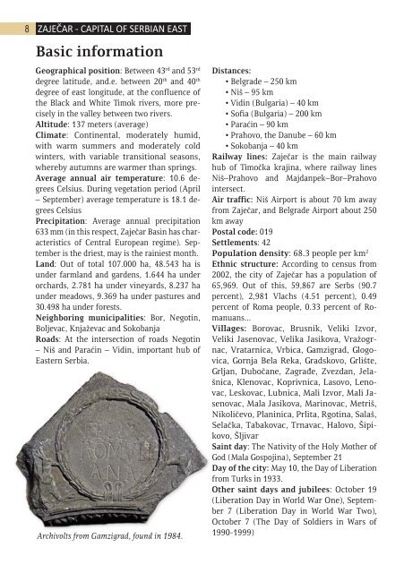
Archivolts from Gam zi gra d, found in 1984.<br />
Distances:<br />
• Belgrade – 250 km<br />
• Niš – 95 km<br />
• Vidin (Bulgaria) – 40 km<br />
• Sofia (Bulgaria) – 200 km<br />
• Paraćin – 90 km<br />
• Prahovo, the Danube – 60 km<br />
• Sokobanja – 40 km<br />
Railway lines: Zaječar is the main railway<br />
hub of Timočka krajina, where railway lines<br />
Niš–Pra ho vo and Majdanpek–Bor–Prahovo<br />
intersect.<br />
Air traffic: Niš Airport is about 70 km away<br />
from Zaječar, and Belgrade Airport about 250<br />
km away<br />
Postal code: 019<br />
Settlements: 42<br />
Population density: 68.3 people per km 2<br />
Ethnic structure: According to census from<br />
2002, the city of Zaječar has a population of<br />
65,969. Out of this, 59,867 are Serbs (90.7<br />
percent), 2,981 Vlachs (4.51 percent), 0.49<br />
percent of Roma people, 0.33 percent of Romanuans...<br />
Villages: Bo ro vac, Bru snik, Ve li ki Iz vor,<br />
Ve li ki Ja se no vac, Ve li ka Ja si ko va, Vra žo grnac,<br />
Vra tar ni ca, Vr bi ca, Gam zi grad, Glo govi<br />
ca, Gor nja Be la Re ka, Grad sko vo, Gr li šte,<br />
Gr ljan, Du bo ča ne, Za gra đe, Zve zdan, Je lašni<br />
ca, Kle no vac, Ko priv ni ca, La so vo, Le novac,<br />
Le sko vac, Lub ni ca, Ma li Iz vor, Ma li Jase<br />
no vac, Ma la Ja si ko va, Ma ri no vac, Me triš,<br />
Ni ko li če vo, Pla ni ni ca, Pr li ta, Rgo ti na, Sa laš,<br />
Se lač ka, Ta ba ko vac, Tr na vac, Ha lo vo, Ši piko<br />
vo, Šlji var<br />
Saint day: The Nativity of the Holy Mother of<br />
God (Mala Gospojina), September 21<br />
Day of the city: May 10, the Day of Liberation<br />
from Turks in 1933.<br />
Other saint days and jubilees: October 19<br />
(Liberation Day in World War One), September<br />
7 (Liberation Day in World War Two),<br />
October 7 (The Day of Soldiers in Wars of<br />
1990-1999)