

Visit NIDDERDALE
24tyfDC
24tyfDC

Create successful ePaper yourself
Turn your PDF publications into a flip-book with our unique Google optimized e-Paper software.
Did you know ...<br />
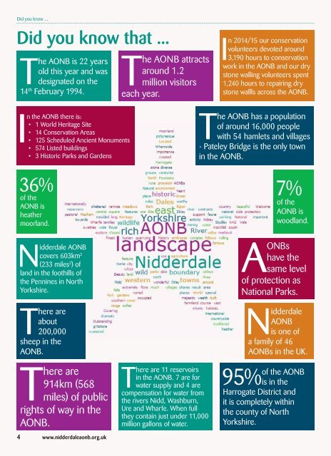
Did you know that ...<br />
The AONB is 22 years<br />
old this year and was<br />
designated on the<br />
14 th February 1994.<br />
The AONB attracts<br />
around 1.2<br />
million visitors<br />
each year.<br />
In 2014/15 our conservation<br />
volunteers devoted around<br />
3,190 hours to conservation<br />
work in the AONB and our dry<br />
stone walling volunteers spent<br />
1,240 hours to repairing dry<br />
stone wallls across the AONB.<br />
About AONBs & the AONB Family<br />
About AONBs & Upper the AONB Nidderdale Family<br />
In the AONB there is:<br />
• 1 World Heritage Site<br />
• 14 Conservation Areas<br />
• 125 Scheduled Ancient Monuments<br />
• 574 Listed buildings<br />
• 3 Historic Parks and Gardens<br />
36%<br />
of the<br />
AONB is<br />
heather<br />
moorland.<br />
Nidderdale AONB<br />
covers 603km 2<br />
(233 miles 2 ) of<br />
land in the foothills of<br />
the Pennines in North<br />
Yorkshire.<br />
There are<br />
about<br />
200,000<br />
sheep in the<br />
AONB.<br />
There are<br />
914km (568<br />
miles) of public<br />
rights of way in the<br />
AONB.<br />
There are 11 reservoirs<br />
in the AONB. 7 are for<br />
water supply and 4 are<br />
compensation for water from<br />
the rivers Nidd, Washburn,<br />
Ure and Wharfe. When full<br />
they contain just under 11,000<br />
million gallons of water.<br />
The AONB has a population<br />
of around 16,000 people<br />
with 54 hamlets and villages<br />
- Pateley Bridge is the only town<br />
in the AONB.<br />
7%<br />
of the<br />
AONB is<br />
woodland.<br />
AONBs<br />
have the<br />
same level<br />
of protection as<br />
National Parks.<br />
Nidderdale<br />
AONB<br />
is one of<br />
a family of 46<br />
AONBs in the UK.<br />
95%<br />
of the AONB<br />
is in the<br />
Harrogate District and<br />
it is completely within<br />
the county of North<br />
Yorkshire.<br />
Nidderdale AONB is located on the eastern flanks of the Pennines in the heart of the Yorkshire<br />
Dales. It shares its western boundary with the Yorkshire Dales National Park, and stretches<br />
south towards the towns of Ilkley and Otley. To the north and east of the AONB are the towns of<br />
Masham, Knaresborough and Harrogate and the city of Ripon.<br />
“An Area of Outstanding Natural Beauty (AONB)<br />
is exactly what it says it is: an outstanding<br />
landscape whose distinctive character and<br />
natural beauty are so precious that it is in the<br />
nation’s interest to safeguard them.”<br />
www.landscapesforlife.org.uk<br />
England:<br />
1. Arnside & Silverdale<br />
2. Blackdown Hills<br />
3. Cannock Chase<br />
4. Chichester Harbour<br />
5. Chilterns<br />
6. Cornwall<br />
7. Cotswolds<br />
8. Cranborne Chase<br />
& West Wiltshire<br />
Downs<br />
9. Dedham Vale<br />
10. Dorset<br />
11. East Devon<br />
12. Forest of Bowland<br />
13. Howardian Hills<br />
14. High Weald<br />
15. Isle of Wight<br />
16. Isles of Scilly<br />
17. Kent Downs<br />
18. Lincolnshire Wolds<br />
19. Malvern Hills<br />
20. Mendip Hills<br />
21. Norfolk Coast<br />
22. North Devon<br />
23. North Pennines<br />
24. North Wessex<br />
Downs<br />
25. Nidderdale<br />
26. Northumberland<br />
Coast<br />
27. Quantock Hills<br />
28. Shropshire Hills<br />
29. Solway Coast<br />
30. South Devon<br />
31. Suffolk Coast &<br />
Heaths<br />
32. Surrey Hills<br />
33. Tamar Valley<br />
England and Wales:<br />
34. Wye Valley<br />
Wales:<br />
35. Clwydian Range &<br />
Dee Valley<br />
36. Gower<br />
37. Lleyn<br />
38. Anglesey<br />
Northern Ireland:<br />
39. Antrim Coast &<br />
Glens<br />
40. Causeway Coast<br />
41. Lagan Valley<br />
42. Mourne<br />
43. Binevenagh<br />
44. Ring of Gullion<br />
45. Sperrin<br />
46. Strangford Lough<br />
Upper Nidderdale © Ange Harker<br />
There are 46 AONBs in the United Kingdom and they<br />
cover 18% of our finest countryside. They were created<br />
alongside National Parks as a result of the ‘National Parks<br />
and Access to the Countryside Act 1949’.<br />
For more information visit<br />
www.landscapesforlife.org.uk<br />
4 www.nidderdaleaonb.org.uk <strong>Visit</strong> Nidderdale AONB 2016 5<br />
45<br />
44<br />
16<br />
40<br />
43<br />
41<br />
42<br />
39<br />
46<br />
6<br />
37<br />
38<br />
22<br />
36<br />
33<br />
30<br />
29<br />
35<br />
28<br />
2<br />
27<br />
11<br />
1<br />
34<br />
12<br />
23<br />
20<br />
8<br />
19<br />
10<br />
26<br />
25<br />
3<br />
we are here<br />
7<br />
13<br />
24<br />
15<br />
5<br />
4<br />
18<br />
32<br />
14<br />
21<br />
9<br />
31<br />
17<br />
Map courtesy of www.landscapesforlife.org.uk