
Create successful ePaper yourself
Turn your PDF publications into a flip-book with our unique Google optimized e-Paper software.
Malta Business Review<br />
ERC STORY<br />
Is digital mapping the new media?<br />
By Sybille Lammes<br />
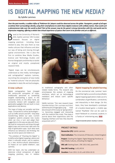
Over the past months, a sudden influx of ‘Pokémon Go’ players could be observed across the globe. Youngsters, people of <strong>all</strong> ages<br />
scrutinise their surroundings silently, using their smartphones to catch those digital creatu<strong>res</strong> with unlikely names. How could such<br />
a phenomenon take over the world so fast? Part of the answer may be the game’s strong interaction with the real-world and its<br />
imp<strong>res</strong>sive mapping, offering a whole new virtual experience of spaces that seem to be familiar and yet so different.<br />
Based at the University of Warwick<br />
(UK), Sybille Lammes’ ERC-funded<br />
<strong>res</strong>earch focuses on digital<br />
mapping practices - including those<br />
related to play. She sees them as new<br />
media cultu<strong>res</strong> that influence and alter<br />
our way of being and moving through<br />
spatial environments. She is also the<br />
first to combine New Media Studies,<br />
Science and Technology Studies and<br />
Human Geography and thereby to tackle<br />
an original and mostly unexplored<br />
<strong>res</strong>earch field.<br />
“Digital maps can be simultaneously<br />
understood as new media, technologies<br />
and cartographies” explains Lammes,<br />
nourishing the conception of new media<br />
as “material cultu<strong>res</strong>” that are physic<strong>all</strong>y<br />
embedded in daily life and technologies.<br />
A new culture<br />
Digital cartographies have changed<br />
the century-old conception of maps,<br />
tradition<strong>all</strong>y perceived as something<br />
tangible rep<strong>res</strong>enting a space. In the<br />
numerical world, on the other hand, we<br />
constantly interact with navigation and<br />
geolocation gadgets that are built in most<br />
applications and devices.<br />
The maps of today are versatile real-time<br />
maps. Connected to online technologies –<br />
such as traffic sensors and GPS – they keep<br />
transforming before our eyes. Current<br />
navigation systems propose new routes<br />
when we miss a turn and adapt their<br />
suggestions to the way we play with them.<br />
We look for <strong>res</strong>taurants and shops through<br />
digital maps and some even date with the<br />
help of geolocation apps. Such daily tools<br />
influence our behaviour and thinking, the<br />
way we sense space and relate to it:<br />
“The ambition of “Charting the Digital” is<br />
to define what digital mapping is about and<br />
what it cultur<strong>all</strong>y entails, and to explore,<br />
as a new techno-cultural phenomenon,<br />
its impact on our spatial relations”, says<br />
Lammes.<br />
With her team, she has undertaken an<br />
extensive critical comparison of digital<br />
mapping practices, also in relation<br />
to traditional cartography and other<br />
related media forms. The <strong>res</strong>earch also<br />
encompasses the analysis of mapping<br />
interfaces, which act as technological<br />
mediators and induce users’ specific<br />
behaviour.<br />
Sybille Lammes: “Our own <strong>res</strong>earch team<br />
membershttps://erc.europa.eu/sites/<br />
<strong>all</strong>/themes/erc/images/gloss.png have<br />
become part of the study, by “going native”,<br />
i.e. becoming engaged and interacting<br />
with the material they study. They keep a<br />
journal about their experiences with the<br />
mapping interface and how they become<br />
acquainted with it”.<br />
PROJECT DETAILS<br />
Researcher (PI): Sybille Lammes<br />
Digital mapping for playful learning<br />
On the commercial side, Lammes’ team<br />
noted that highly successful and profitable<br />
digital mapping applications make use of a<br />
combination of gamification, connectivity<br />
and interactivity in their design. On this<br />
basis, they have developed a prototype<br />
of a location-based game: a mobile app<br />
named ‘Playfields’ that can be used to<br />
teach fieldwork to university students in<br />
a ‘hands on’ entertaining way. <strong>MBR</strong><br />
Image & <strong>res</strong>earcher picture: Courtesy S. Lammes<br />
Host institution: The University Of Warwick, United Kingdom<br />
Project: Charting the Digital: Digital Mapping Practices as<br />
New Media Cultu<strong>res</strong>, (Charting the Digital)<br />
ERC c<strong>all</strong>: Starting Grant , ERC-2011-StG, panel SH5<br />
Max ERC funding: 1,422,453 €<br />
Duration: From 2011-11-01 until 2016-10-31<br />
26