

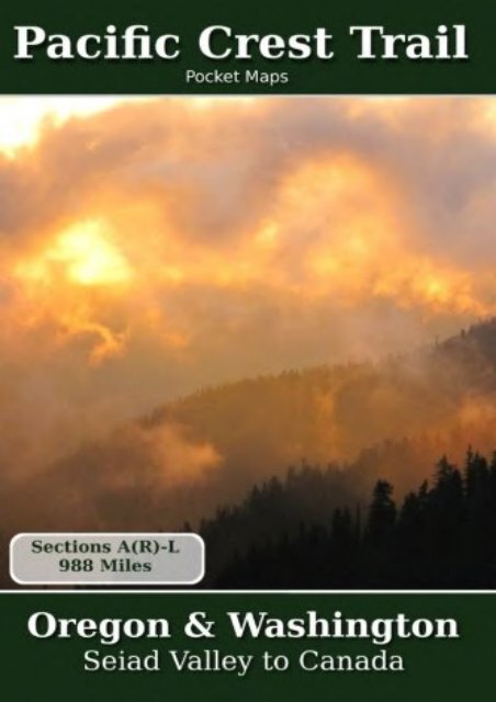
Pacific Crest Trail Pocket Maps - Oregon Washington
Pacific Crest Trail Pocket Maps - Oregon Washington
Pacific Crest Trail Pocket Maps - Oregon Washington

You also want an ePaper? Increase the reach of your titles
YUMPU automatically turns print PDFs into web optimized ePapers that Google loves.
<strong>Pacific</strong> <strong>Crest</strong> <strong>Trail</strong> <strong>Pocket</strong> <strong>Maps</strong> - <strong>Oregon</strong> <strong>Washington</strong> (K. Scott Parks) <strong>Oregon</strong> &<strong>Washington</strong>7th Edition - November 1, 2015 The <strong>Pacific</strong> <strong>Crest</strong> <strong>Trail</strong> <strong>Pocket</strong> Map Series is a complete and concise set of topographic maps created with digitized base maps covering every step of the 2,650 mile trail from Mexico to Canada. The most current data available! Completely verified and updated from 6,255 audio notes and 631,230 GPS points collected during authors 2nd hike of the <strong>Pacific</strong> <strong>Crest</strong> <strong>Trail</strong>. The land cover, hydrology and contour data used to create these maps has been collected within the last 5 years, presented in a completely uniform manner across all 374 maps. No other complete PCT map set available can say this! Features: + 374 full color, digitized topographic maps + Seamless. Uniform styles, colors, fonts and unit of measure. + Beautiful 3D hill shading + Highly detailed elevation chart on each map + Decimal degrees latitude/longitude and UTM Grids + Meta data for each section, climate, roads, etc + Section overview maps with elevations + 1:38500 scale, 6" x 9" (15.2cm x 22.9cm) format for easy pack stowage + Accumulated trail mileage every mile + Resupply locations within 90 miles of map center + Data book information printed at each locale on the maps + Accurate trail trace + Over 2,400 resupply, water, trail junction, camp site, etc, locations<br />
+ Volunteer trail crew recognition on each map Part of a 3 volume set, these 6" x 9" full color topographic maps are designed to stow easily into your pack, without sacrificing the detail required by a hiker in the back country. All 3 <strong>Pacific</strong> <strong>Crest</strong> <strong>Trail</strong> <strong>Pocket</strong> <strong>Maps</strong> volumes are: Southern California, Northern California and <strong>Oregon</strong>/<strong>Washington</strong>.<br />
<strong>Pacific</strong> <strong>Crest</strong> <strong>Trail</strong> <strong>Pocket</strong> <strong>Maps</strong> - <strong>Oregon</strong> <strong>Washington</strong>
●<br />
●<br />
●<br />
●<br />
Author : K. Scott Parks<br />
●<br />
●<br />
Pages : 176 pages<br />
Publisher : CreateSpace Independent Publishing Platform 2011-<br />
12-06<br />
Language : English<br />
ISBN-10 : 1467967556<br />
ISBN-13 : 9781467967556
<strong>Pacific</strong> <strong>Crest</strong> <strong>Trail</strong> <strong>Pocket</strong> <strong>Maps</strong> - <strong>Oregon</strong><br />
<strong>Washington</strong>


![World Decorator [Enlarged and Laminated] (National Geographic Reference Map)](https://img.yumpu.com/59273647/1/184x260/world-decorator-enlarged-and-laminated-national-geographic-reference-map.jpg?quality=85)
![Absaroka-Beartooth Wilderness East [Cooke City, Red Lodge] (National Geographic Trails Illustrated Map)](https://img.yumpu.com/59273645/1/184x260/absaroka-beartooth-wilderness-east-cooke-city-red-lodge-national-geographic-trails-illustrated-map.jpg?quality=85)
