Climate Action 2011-2012

Create successful ePaper yourself
Turn your PDF publications into a flip-book with our unique Google optimized e-Paper software.
Special Feature<br />
Esri<br />
Adapting to climate change<br />
GeoDesign provides a framework for action<br />
By Jack Dangermond, President and CEO, Esri<br />
The Earth’s climate is changing, leading to serious problems<br />
such as food security, health, and public safety for humanity.<br />
As our environment changes around us, we need to<br />
adapt swiftly. But where do we start? Should we reinforce<br />
or rebuild existing structures? Or should we abandon<br />
existing settlements and relocate the population in some<br />
cases? And how can mass rebuilding/relocation efforts be<br />
best accomplished from the human, environmental, and<br />
economic perspectives?<br />
GeoDesign is a framework for understanding the complex<br />
relationships between human designed settlements and<br />
the changing environment, for quickly planning ways to<br />
adapt existing communities and build new ones in a more<br />
sustainable manner. This methodology helps us to assess risk,<br />
identify change, create synergies, develop strategies, adapt to<br />
change, and monitor the results. A merging of geographic<br />
information system (GIS) technology with spatial design<br />
principles, GeoDesign takes an interdisciplinary, synergistic<br />
approach to solve the critical problems of future design to<br />
optimise location, orientation, and the features of projects<br />
from local to global scales.<br />
By bringing social, environmental, agricultural,<br />
meteorological, and other sciences into a common<br />
geographic perspective, people can better see the optimal<br />
solutions needed for planning and building our future.<br />
Governments, NGO’s, businesses, and civil society<br />
communities already use the GeoDesign approach to<br />
minimise climate impacts, increase resiliency, predict cause<br />
and effect, calculate sustainability capacity, rank risk levels,<br />
allocate resources, and prioritise action.<br />
By incorporating geographic technologies such as<br />
visualisation and modeling into the analysis of community<br />
development, people can intelligently answer far reaching<br />
design questions such as these.<br />
The GeoDesign framework lets us design and test various<br />
alternatives, thereby helping to make the most educated<br />
and informed decisions for adapting human kind to a<br />
rapidly changing environment and world. It acknowledges<br />
the inseparable relationship between society and nature<br />
and lets us take an active role in designing where and how<br />
we live.<br />
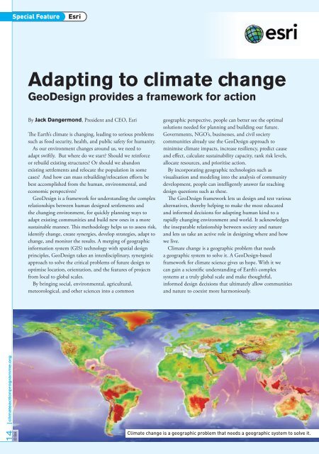
<strong>Climate</strong> change is a geographic problem that needs<br />
a geographic system to solve it. A GeoDesign-based<br />
framework for climate science gives us hope. With it we<br />
can gain a scientific understanding of Earth’s complex<br />
systems at a truly global scale and make thoughtful,<br />
informed design decisions that ultimately allow communities<br />
and nature to coexist more harmoniously.<br />
14 climateactionprogramme.org<br />
© Esri<br />
<strong>Climate</strong> change is a geographic problem that needs a geographic system to solve it.