
You also want an ePaper? Increase the reach of your titles
YUMPU automatically turns print PDFs into web optimized ePapers that Google loves.
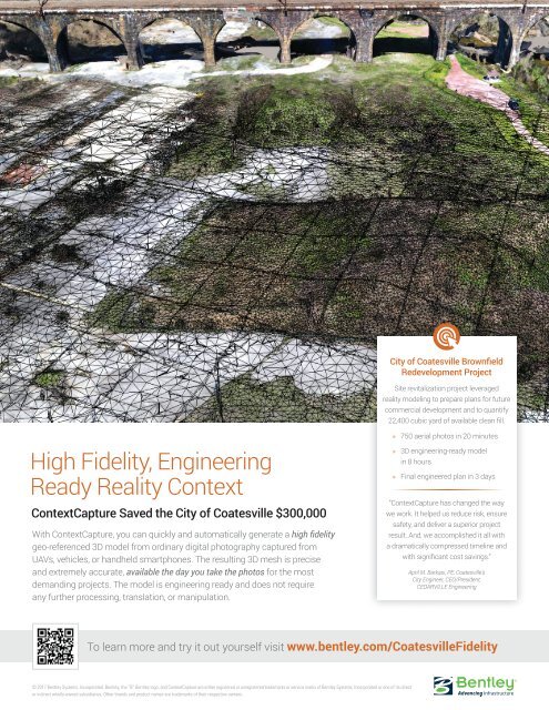
City of Coatesville Brownfield<br />
Redevelopment Project<br />
Site revitalization project leveraged<br />
reality modeling to prepare plans for future<br />
commercial development and to quantify<br />
22,400 cubic yard of available clean fill.<br />
High Fidelity, Engineering<br />
Ready Reality Context<br />
ContextCapture Saved the City of Coatesville $300,000<br />
With ContextCapture, you can quickly and automatically generate a high fidelity<br />
geo-referenced 3D model from ordinary digital photography captured from<br />
UAVs, vehicles, or handheld smartphones. The resulting 3D mesh is precise<br />
and extremely accurate, available the day you take the photos for the most<br />
demanding projects. The model is engineering ready and does not require<br />
any further processing, translation, or manipulation.<br />
» 750 aerial photos in 20 minutes<br />
» 3D engineering-ready model<br />
in 8 hours<br />
» Final engineered plan in 3 days<br />
“ContextCapture has changed the way<br />
we work. It helped us reduce risk, ensure<br />
safety, and deliver a superior project<br />
result. And, we accomplished it all with<br />
a dramatically compressed timeline and<br />
with significant cost savings.”<br />
April M. Barkasi, PE, Coatesville’s<br />
City Engineer, CEO/President,<br />
CEDARVILLE Engineering<br />
To learn more and try it out yourself visit www.bentley.com/CoatesvilleFidelity<br />
© 2017 Bentley Systems, Incorporated. Bentley, the “B” Bentley logo, and ContextCapture are either registered or unregistered trademarks or service marks of Bentley Systems, Incorporated or one of its direct<br />
or indirect wholly-owned subsidiaries. Other brands and product names are trademarks of their respective owners.