
You also want an ePaper? Increase the reach of your titles
YUMPU automatically turns print PDFs into web optimized ePapers that Google loves.
egulations do not document flood-risk areas in cities and towns, and<br />
therefore cannot prohibit new development in those areas (Khailani &<br />
Perera, 2013). Local development plans are prepared without stakeholder<br />
participation and indigenous knowledge. For all of these reasons, there is<br />
an absence of “resilience thinking” in the existing local development plan<br />
(Khailani & Perera, 2013).<br />
Structure of flood disaster management governance: There are<br />
three levels of disaster management authorities in Malaysia (N. W. Chan,<br />
2012). They are 1) the National Disaster Management and Relief<br />
Committee 2) the State Disaster Management and Relief Committee, and<br />
3) the District Disaster Management and Relief Committee (DDMRC).<br />
However, there is often lack of coordination between these three levels of<br />
management committees (N. W. Chan, 2012). The DDMRC is chaired by<br />
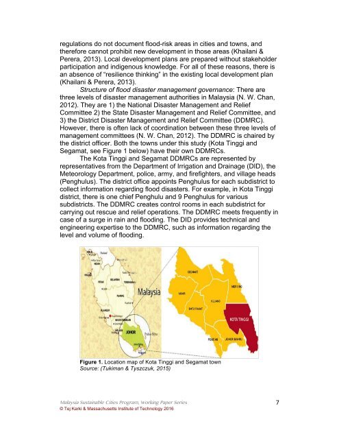
the district officer. Both the towns under this study (Kota Tinggi and<br />
Segamat, see Figure 1 below) have their own DDMRCs.<br />
The Kota Tinggi and Segamat DDMRCs are represented by<br />
representatives from the Department of Irrigation and Drainage (DID), the<br />
Meteorology Department, police, army, and firefighters, and village heads<br />
(Penghulus). The district office appoints Penghulus for each subdistrict to<br />
collect information regarding flood disasters. For example, in Kota Tinggi<br />
district, there is one chief Penghulu and 9 Penghulus for various<br />
subdistricts. The DDMRC creates control rooms in each subdistrict for<br />
carrying out rescue and relief operations. The DDMRC meets frequently in<br />
case of a surge in rain and flooding. The DID provides technical and<br />
engineering expertise to the DDMRC, such as information regarding the<br />
level and volume of flooding.<br />
Figure 1. Location map of Kota Tinggi and Segamat town<br />
Source: (Tukiman & Tyszczuk, 2015)<br />
Malaysia Sustainable Cities Program, Working Paper Series<br />
© Tej <strong>Karki</strong> & Massachusetts Institute of Technology 2016<br />
7