West Lake CAG NRRB Submission REVISED ADDENDUM January 4 2018

Create successful ePaper yourself
Turn your PDF publications into a flip-book with our unique Google optimized e-Paper software.
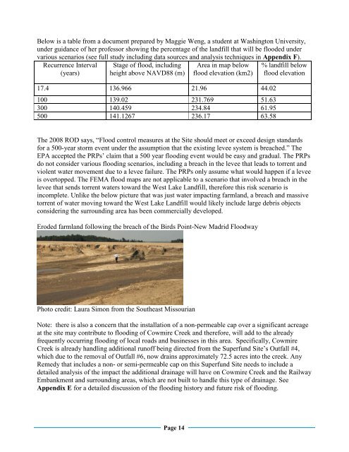
Below is a table from a document prepared by Maggie Weng, a student at Washington University,<br />
under guidance of her professor showing the percentage of the landfill that will be flooded under<br />
various scenarios (see full study including data sources and analysis techniques in Appendix F).<br />
Recurrence Interval<br />
(years)<br />
Stage of flood, including<br />
height above NAVD88 (m)<br />
Area in map below<br />
flood elevation (km2)<br />
17.4 136.966 21.96 44.02<br />
100 139.02 231.769 51.63<br />
300 140.459 234.84 61.95<br />
500 141.1267 236.17 63.58<br />
% landfill below<br />
flood elevation<br />
The 2008 ROD says, “Flood control measures at the Site should meet or exceed design standards<br />
for a 500-year storm event under the assumption that the existing levee system is breached.” The<br />
EPA accepted the PRPs’ claim that a 500 year flooding event would be easy and gradual. The PRPs<br />
do not consider various flooding scenarios, including a breach in the levee that leads to torrent and<br />
violent water movement due to a levee failure. The PRPs only assume what would happen if a levee<br />
is overtopped. The FEMA flood maps are not applicable to a scenario that involved a breach in the<br />
levee that sends torrent waters toward the <strong>West</strong> <strong>Lake</strong> Landfill, therefore this risk scenario is<br />
incomplete. Unlike the below picture that was just water impacting farmland, a breach and massive<br />
torrent of water moving toward the <strong>West</strong> <strong>Lake</strong> Landfill would likely include large debris objects<br />
considering the surrounding area has been commercially developed.<br />
Eroded farmland following the breach of the Birds Point-New Madrid Floodway<br />
Photo credit: Laura Simon from the Southeast Missourian<br />
Note: there is also a concern that the installation of a non-permeable cap over a significant acreage<br />
at the site may contribute to flooding of Cowmire Creek and therefore, will add to the already<br />
frequently occurring flooding of local roads and businesses in this area. Specifically, Cowmire<br />
Creek is already handling additional runoff being directed from the Superfund Site’s Outfall #4,<br />
which due to the removal of Outfall #6, now drains approximately 72.5 acres into the creek. Any<br />
Remedy that includes a non- or semi-permeable cap on this Superfund Site needs to include a<br />
detailed analysis of the impact the additional drainage will have on Cowmire Creek and the Railway<br />
Embankment and surrounding areas, which are not built to handle this type of drainage. See<br />
Appendix E for a detailed discussion of the flooding history and future risk of flooding.<br />
Page 14