West Lake CAG NRRB Submission REVISED ADDENDUM January 4 2018

You also want an ePaper? Increase the reach of your titles
YUMPU automatically turns print PDFs into web optimized ePapers that Google loves.
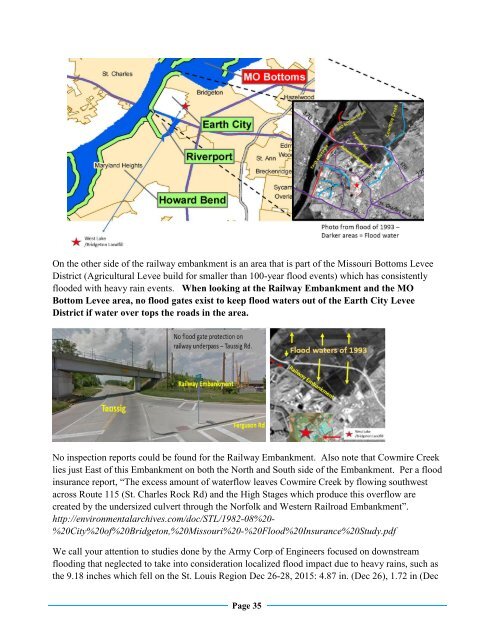
On the other side of the railway embankment is an area that is part of the Missouri Bottoms Levee<br />
District (Agricultural Levee build for smaller than 100-year flood events) which has consistently<br />
flooded with heavy rain events. When looking at the Railway Embankment and the MO<br />
Bottom Levee area, no flood gates exist to keep flood waters out of the Earth City Levee<br />
District if water over tops the roads in the area.<br />
No inspection reports could be found for the Railway Embankment. Also note that Cowmire Creek<br />
lies just East of this Embankment on both the North and South side of the Embankment. Per a flood<br />
insurance report, “The excess amount of waterflow leaves Cowmire Creek by flowing southwest<br />
across Route 115 (St. Charles Rock Rd) and the High Stages which produce this overflow are<br />
created by the undersized culvert through the Norfolk and <strong>West</strong>ern Railroad Embankment”.<br />
http://environmentalarchives.com/doc/STL/1982-08%20-<br />
%20City%20of%20Bridgeton,%20Missouri%20-%20Flood%20Insurance%20Study.pdf<br />
We call your attention to studies done by the Army Corp of Engineers focused on downstream<br />
flooding that neglected to take into consideration localized flood impact due to heavy rains, such as<br />
the 9.18 inches which fell on the St. Louis Region Dec 26-28, 2015: 4.87 in. (Dec 26), 1.72 in (Dec<br />
Page 35