Rebirth of Water - 2017-2018
ACAP Saint John, Water Quality and Fish Communities Monitoring Report http://www.acapsj.org
ACAP Saint John, Water Quality and Fish Communities Monitoring Report
http://www.acapsj.org

Create successful ePaper yourself
Turn your PDF publications into a flip-book with our unique Google optimized e-Paper software.
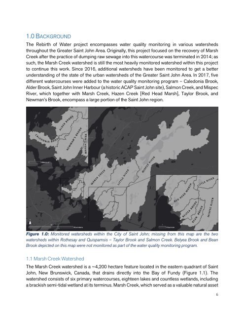
1.0 BACKGROUND<br />
The <strong>Rebirth</strong> <strong>of</strong> <strong>Water</strong> project encompasses water quality monitoring in various watersheds<br />
throughout the Greater Saint John Area. Originally, this project focused on the recovery <strong>of</strong> Marsh<br />
Creek after the practice <strong>of</strong> dumping raw sewage into this watercourse was terminated in 2014; as<br />
such, the Marsh Creek watershed is still the most heavily monitored watershed within this project<br />
to continue this work. Since 2016, additional watersheds have been monitored to get a better<br />
understanding <strong>of</strong> the state <strong>of</strong> the urban watersheds <strong>of</strong> the Greater Saint John Area. In <strong>2017</strong>, five<br />
different watercourses were added to the water quality monitoring program – Caledonia Brook,<br />
Alder Brook, Saint John Inner Harbour (a historic ACAP Saint John site), Salmon Creek, and Mispec<br />
River, which together with Marsh Creek, Hazen Creek [Red Head Marsh], Taylor Brook, and<br />
Newman’s Brook, encompass a large portion <strong>of</strong> the Saint John region.<br />
Figure 1.0: Monitored watersheds within the City <strong>of</strong> Saint John; missing from this map are the two<br />
watersheds within Rothesay and Quispamsis – Taylor Brook and Salmon Creek. Belyea Brook and Bean<br />
Brook depicted on this map were not monitored as part <strong>of</strong> the water quality monitoring program.<br />
1.1 Marsh Creek <strong>Water</strong>shed<br />
The Marsh Creek watershed is a ~4,200 hectare feature located in the eastern quadrant <strong>of</strong> Saint<br />
John, New Brunswick, Canada, that drains directly into the Bay <strong>of</strong> Fundy (Figure 1.1). The<br />
watershed consists <strong>of</strong> six primary watercourses, eighteen lakes and countless wetlands, including<br />
a brackish semi-tidal wetland at its terminus. Marsh Creek, which served as a valuable natural asset<br />
6