Assessing torrential endangered areas in Bavaria – consideration of log jams at culverts and bridges
According to the Bavarian Water Act there is an obligation for the water management authorities to determine torrential endangered areas. In a legal sense these areas are primarily potential flood areas however under consideration of typical torrential characteristics. Especially the involvement of solids in the process has to be regarded. Therefore a standardized modular approach to assess torrential hazards was developed at the Bavarian Environment Agency.
According to the Bavarian Water Act there is an obligation for the water management authorities to determine torrential endangered areas. In a legal sense these areas are primarily potential flood areas however under consideration of typical torrential characteristics. Especially the involvement of solids in the process has to be regarded. Therefore a standardized modular approach to assess torrential hazards was developed at the Bavarian Environment Agency.

Create successful ePaper yourself
Turn your PDF publications into a flip-book with our unique Google optimized e-Paper software.
2.4.2.3 Wood dimensions<br />
F<strong>in</strong>ally woody debris size (length <strong>and</strong> diameter)<br />
as well as local <strong>and</strong> hydraulic framework conditions<br />
affect the risk <strong>of</strong> jamm<strong>in</strong>g. The maximum length <strong>of</strong><br />
the <strong>log</strong>s can approxim<strong>at</strong>ely be estim<strong>at</strong>ed tak<strong>in</strong>g the<br />
m<strong>in</strong>imum channel width upstream <strong>of</strong> the bridge as a<br />
reference. A m<strong>in</strong>imum flow depth (h) <strong>of</strong> half the<br />
<strong>log</strong>s’ diameter (d) is required for woody debris<br />
transport to beg<strong>in</strong> [Imh<strong>of</strong> 2008; Lange & Bezzola<br />
2006].<br />
d<br />
h (1b<br />
)<br />
2<br />
2.5 2D HYDRAULIC MODELING<br />
The determ<strong>in</strong><strong>at</strong>ion <strong>of</strong> the <strong>torrential</strong> <strong>endangered</strong><br />
area is achieved by a 2D hydraulic simul<strong>at</strong>ion us<strong>in</strong>g<br />
the programme Hydro_AS-2D. By default a<br />
simul<strong>at</strong>ion <strong>of</strong> the basic scenario without any <strong>log</strong><br />
<strong>jams</strong> or sediment accumul<strong>at</strong>ion is carried out. A<br />
maximum <strong>of</strong> two further scenarios consider<strong>in</strong>g <strong>log</strong><br />
<strong>jams</strong>, sediment accumul<strong>at</strong>ions or both can be taken<br />
<strong>in</strong>to account <strong>and</strong> simul<strong>at</strong>ed. Additional scenarios<br />
only should be considered if they most likely occur<br />
dur<strong>in</strong>g a design event.<br />
The level <strong>of</strong> blockage def<strong>in</strong>ed <strong>in</strong> the previous<br />
steps has to be considered appropri<strong>at</strong>ely. Depend<strong>in</strong>g<br />
on the channel course two configur<strong>at</strong>ions are to be<br />
dist<strong>in</strong>guished. In curved channel courses, the <strong>log</strong><br />
jam is <strong>in</strong>corpor<strong>at</strong>ed <strong>in</strong>to the model by mov<strong>in</strong>g the<br />
bridge’s outer abutment <strong>in</strong>to the channel bed. In<br />
stretched channel courses, the lowest l<strong>in</strong>e <strong>of</strong><br />
structure is lowered by the amount needed to<br />
reproduce the level <strong>of</strong> blockage. The reduced<br />
channel section makes it possible to show effects <strong>of</strong><br />
the <strong>log</strong> jam on the extent <strong>of</strong> the flooded area.<br />
The method <strong>of</strong> determ<strong>in</strong><strong>in</strong>g the level <strong>of</strong><br />
blockage <strong>and</strong> the subsequent implement<strong>at</strong>ion <strong>in</strong>to<br />
the hydraulic model is illustr<strong>at</strong>ed <strong>in</strong> the follow<strong>in</strong>g<br />
case study.<br />
2.5.1 Case study Weissl<strong>of</strong>er, Reit im<br />
W<strong>in</strong>kl<br />
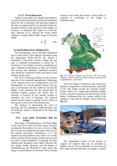
The bridge <strong>at</strong> Entfelderstrasse is the third bridge<br />
<strong>in</strong> the local area <strong>of</strong> Reit im W<strong>in</strong>kl (Upper <strong>Bavaria</strong>)<br />
cross<strong>in</strong>g the Weissl<strong>of</strong>er river (see overview <strong>in</strong> Fig.<br />
11). It is thus not regarded as the most critical one <strong>in</strong><br />
the hazard assessment. Nonetheless, it is still<br />
capable <strong>of</strong> pos<strong>in</strong>g problems s<strong>in</strong>ce there is no woody<br />
debris retention <strong>and</strong> the <strong>bridges</strong> further upstream did<br />
not show a high probability <strong>of</strong> jamm<strong>in</strong>g <strong>and</strong> thus<br />
hold<strong>in</strong>g back <strong>in</strong>com<strong>in</strong>g woody debris. Between the<br />
last bridge further upstream <strong>and</strong> the bridge <strong>at</strong><br />
Entfelderstrasse the Weissl<strong>of</strong>er’s outer bank runs<br />
along a wooded hillside toe for about 700 m. If bank<br />
erosion occurs along this stretch, woody debris is<br />
expected to accumul<strong>at</strong>e <strong>at</strong> the bridge <strong>at</strong><br />
Entfelderstrasse.<br />
Fig. 11 Overview Germany <strong>and</strong> <strong>Bavaria</strong>. The case study<br />
c<strong>at</strong>chment <strong>of</strong> the Weissl<strong>of</strong>er near Reit im W<strong>in</strong>kl, Upper <strong>Bavaria</strong>,<br />
is highlighted by a green frame<br />
Due to the bridge’s dimensions <strong>and</strong> constructive<br />
design it is regarded as a critical structure, especially<br />
as the flow depth exceeds the clearance height.<br />
Further aspects are: rough <strong>and</strong> unsurfaced channel<br />
bottom, structures upstream <strong>and</strong> downstream <strong>of</strong> the<br />
bridge. Furthermore the free surface width <strong>of</strong> the<br />
channel is wider than the bridge’s <strong>in</strong>ner width (see<br />
Fig. 12).<br />
Fig. 12 Bridge Entfelderstrasse<br />
The longitud<strong>in</strong>al section <strong>of</strong> the channel is<br />
stepped, the channel route can be classified as<br />
slightly curved. The <strong>log</strong> diameters are less than the<br />
flow depth <strong>and</strong> the maximum tree length is smaller