You also want an ePaper? Increase the reach of your titles
YUMPU automatically turns print PDFs into web optimized ePapers that Google loves.
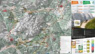
orari
ARABBA
MARMOLADA
SUMMERPASS
P
R
O
M
O
SUMMERPASS
COME FUNZIONA?
PAESAGGI, COLORI ED EMOZIONI
In inverno piste bianche perfettamente preparate, in estate
profumati prati fioriti e panorami da sogno.
FASCINATION MADE OF UNIQUE
LANDSCAPE AND MARVELLOUS
MOUNTAINS
ARABBA • MARMOLADA
SUMMERPASS
Arabba Marmolada Summerpass è la tessera di valle che permette
di raggiungere tutti i percorsi e le attrazioni in quota utilizzando gli
impianti di risalita durante la propria vacanza!
• Una tessera nominativa valida su tutti gli impianti del comprensorio
Arabba Marmolada aperti durante l’estate;
• Due tagli a disposizione, da scegliere in base alle proprie esigenze:
3 giorni su 4 o 5 giorni su 7, anche non continuativi;
• Riduzioni e condizioni speciali per ragazzi e bambini;
Le Dolomiti offrono entrambe le cose: Sia in abito invernale sia in
quello estivo, il Patrimonio Mondiale UNESCO incanta in ogni
stagione. Il fascino indescrivibile che d'estate trasforma le montagne in
una galassia di escursioni e gite in bike. Nessun amante della montagna,
della bicicletta o appassionato di escursioni può resistere a questa
tentazione. Le Dolomiti si trasformano in estate in un mondo di
superlative avventure. Che si tratti di escursionismo o tour in
bicicletta, nelle Dolomiti ogni sport trova il suo posto.
Oltre 100 impianti di risalita possono essere utilizzati con un solo
biglietto, la tessera SuperSummer. In questo modo, quote apparentemente
irraggiungibili vengono superate in pochissimo tempo.
Le Dolomiti ti aspettano per una vacanza estiva all'insegna dello
sport!
IMPIANTI APERTI
OPEN LIFTS
A Funifor Arabba - Porta Vescovo
B Seggiovia Padon II
C
Telecabina Fodom
E Seggiovia Campolongo
F Seggiovia Cherz I
G Funivie della Marmolada
Perfectly groomed white slopes in winter or fragrant flower
meadows and dreamlike scenery in summer? The
Dolomites offer both. Whether kitted out in its winter or
summer best, this UNSECO World Heritage Site is captivating at any
time of year. A fascinating array of grey rock formations, which in the
summer turn into a hiking and biking galaxy. The temptation is too
much for any keen
mountaineer, biker or hillwalker to resist. When the Dolomites call,
you can’t help but venturing high up into this fantastic mountain
landscape.
The Dolomites transform into a first-class adventure world during the
summer. Whether it’s hiking or biking, the Dolomites are the perfect
place for any sport.
Over 100 open lifts are accessible with one ticket, the SuperSummer
lift pass. Seemingly unattainable heights can be overcome
effortlessly and in no time. No matter which sport you pick for your
holiday in the Dolomites, the mountain world is at your fingertips.
1
CARD
100
LIFTS
12
VALLEYS
D Seggiovia Burz
ARABBA
MARMOLADA
SUMMERPASS
CONTATTI
CONTACTS
P
R
O
M
O
SUMMERPASS
HOW IT WORKS?
Arabba Fodom Turismo
Via Mesdì 66/A-B Arabba
32020 Livinallongo del Col di Lana (BL)
Tel: +39 0436 79130
E-Mail: info@arabba.it
www.arabba.it
Consorzio Turistico
Marmolada Rocca Pietore Dolomiti
Località Sottoguda, 33
I 32023 Rocca Pietore (BL)
Tel. +39 0437 722277
E-Mail: info@marmolada.com
www.marmolada.com
Arabba Marmolada Summerpass is a brand new Card which allows
you to reach all the paths and the amenities on the Top of our
Mountains during your holiday!
• A single Card valid on all the lifts of the Arabba - Marmolada area
open during Summertime;
• Two options available according to different needs: 3 days out of 4
or 5 days out of 7;
• Discounts and special fares for boys and children;
Innsbruck
bolzano
a22
cortina
d’ampezzo
arabba
MARMOLADA
belluno
trento
a22
a27
a4
a4
treviso
trieste
a4
venezia
verona
PREZZI & CONDIZIONI
PRICES & CONDITIONS
estate 2020
summer 2020 timetableS
GIORNATE / DAYS
ADULTI / ADULTS
* JUNIOR -30%
IMPIANTO / LIFT
PERIODO
ORARI
3 su 4
€ 50
€ 35
A
Funifor Arabba
- Porta Vescovo
13/06 - 27/09/2020
08:30 - 17:00
5 su 7
€ 60
€ 42
B
Seggiovia Padon II
27/06 - 06/09/2020
09:15 - 16:40
Baby GRATIS (nati dopo il 25/05/2012) se accompagnati
da adulto.
Per richiedere sconti e agevolazioni, ricorda di avere sempre
con te un documento di identià valido.
* Junior: < 16 anni nati dopo il 25.05.2004).
C
D
E
Telecabina Fodom
Seggiovia Burz
Seggiovia
Campolongo
27/06 - 27/09/2020
13/06 - 13/09/2020
13/06 - 13/09/2020
09:00 - 17:30
09:00 - 17:00
09:00 - 17:00
FREE children (born after 25/05/2012) together with an
adult.
To access discounts and benefits, remember to show a valid
ID card. * Junior: < 16 years old born after 25.05.2004).
F
G
Seggiovia Cherz I
Funivie della
Marmolada
19/07 - 06/09/2020 09:00 - 17:00
04/07 - 13/09/2020 09:00 - 16:00
NEW
SCONTO | DISCOUNT
20%
Funivia Lagazuoi cablecar
con | with
Arabba Marmolada
Summerpass
Suggerimento: controlla sempre gli orari e le comunicazioni esposte
alle stazioni di partenza degli impianti. In caso di temporale, l’esercizio
degli impianti di risalita potrebbe essere sospeso per motivi di sicurezza.
Tips: always check the timetables displayed at the departure stations of
the Lifts. In case of thunderstorm, the operation of the Lifts could be
suspended due to safety reasons.
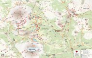
A
1
PORTA VESCOVO
FERRATA DELLE TRINCEE
A
4
PORTA VESCOVO
SENTIERO viel dal pan
c
1
PASSO PORDOI
Ossario del Pordoi
c
4
VIA FERRATA
CESARE PIAZZETTA
E
2
TRAVERSATA
CAMPOLONGO - PASSO PORDOI
G
1
MARMOLADA
VIA FERRATA ETERNA
Ferrata di media difficoltà su roccia di origine vulcanica, si
tratta di un percorso ricco di panorami mozzafiato tra il
gruppo del Sella ed il ghiacciaio della Marmolada,
importante anche dal punto di vista storico in quanto teatro degli
scontri della Prima Guerra Mondiale. Punto di partenza ideale è
Arabba, prendendo la funivia che arriva in cima a Porta Vescovo (mt.
2.478) dalla quale, in soli 15 minuti di cammino si arriva all'attacco
della ferrata. La ferrata delle trincee fu teatro di battaglia durante la
Prima Guerra Mondiale: lungo il percorso è possibile vedere ancora
oggi vecchi appostamenti austriaci, trincee e camminamenti. Da
non perdere il passaggio nelle gallerie (attrezzati di lampada), per
arrivare al bivacco Bontadini e successivamente al Passo Padon. Da
qui, è possibile tornare a Porta Vescovo lungo il sentiero nr. 680
(percorso B2) o scendere ad Arabba lungo il sentiero nr. 699 e nr. 698
in circa due ore e mezza di cammino.
This Via Ferrata is considered a path of medium difficulty.
The rock is mostly of volcanic origins and a beautiful view
on the Sella group and on the Marmolada Glacier makes it
unique. This tour is also important from an historical point of view:
along the way are still visible various Austrian emplacements,
trenches and caves from the battles of the First World War. The
starting point is Arabba via the Porta Vescovo cable car. Once at the
top of Porta Vescovo (mt. 2.478) in 15 minutes walk you arrive at the
starting point of the Via Ferrata. It will take approximately 3 hours to
do all the tour, arriving at the end at Passo Padon.
From there you can decide whether you want to go back down to
Arabba (2 hours and a half down hill) following the trails nr. 699 and
nr. 698 or if you want to come back to the top of Porta Vescovo to
take the cable car via the trail nr. 680 (Route B2).
Si tratta di un sentiero storico, il cui nome deriva dagli
scambi commerciali che avevano luogo anticamente proprio
lungo questo percorso. Si sale da Arabba con la Funivia fino
a Porta Vescovo (mt. 2.478), e si imbocca il sentiero nr. 601 il quale,
scendendo dolcemente lungo la dorsale del Passo Fedaia prosegue
in direzione del Passo Pordoi. L'itinerario si sviluppa senza grosse
difficoltà altimetriche rimanendo sempre in quota, circondato da uno
scenario unico: in basso il lago del Fedaia sovrastato dall’imponente
ghiacciaio della Marmolada, di fronte il gruppo del Sella con il Sas
Becè, il Sassolungo e il Sassopiatto. Una volta arrivati al Passo Pordoi
si consiglia una visita al museo della Grande Guerra e all'Ossario
Germanico. Dal Passo Pordoi si consiglia la discesa con la telecabina
Fodom, che in pochi minuti consente di raggiungere la località Pont de
Vauz per proseguire poi in direzione Arabba lungo prati e pascoli
(percorso C3) con possibilità di incontrare mucche o marmotte.
A historical path, used for commercial exchanges that took
place in ancient times between different valleys. Departure
from Arabba with the Porta Vescovo cableway which takes
you already at an altitude of mt. 2.478, from here take path nr. 601
which, on a slight descent, goes along the ridge of the Fedaia Pass
continuing towards Pordoi. The itinerary develops itself without great
altimetric difficulties, remaining always at high altitude in an unique
scenario; below the Fedaia lake dominated by the imposing Marmolada
glacier, in front of you the Sella group, the Sas Becè, the
Sassolungo and the Sassopiatto. Once at the Pordoi, we recommend
a visit at the museum of the First World War and at the Germanic
Ossuary. From the Pordoi Pass we recommend the descent with the
Fodom cable car that heads to Pont de Vauz and from there continue
another 40 minutes towards Arabba along a path of meadows and
pastures with the possibility to meet cows or marmots (Route C3).
Dopo aver raggiunto il Passo Pordoi con la Cabinovia fodom
(percorso C3), si cammina in leggera salita lungo la strada
che dal Passo porta all'Ossario. L'ossario sorge a mt. 2.239
ed il complesso monumentale è costituito da un torrione a pianta
ottagonale con un largo basamento circolare a due ripiani. Nella cripta
centrale sono stati raccolti i resti di 454 caduti germanici e di 8.128
caduti austro-ungarici provenienti dai vari cimiteri di guerra. Nei
ripiani esterni sono invece tumulati i resti di 842 caduti tedeschi della
Wehrmacht della 2° Guerra Mondiale, provenienti dai cimiteri ubicati
nella zona di Belluno. Il rientro avviene per lo stesso itinerario.
After having reached the Passo Pordoi with the Cable Car,
(Route C3) start walking on the slightly ascending path that
heads to the Ossuary. The Ossuary is located at mt. 2.239
and the whole monumental complex is built of a eight-faced tower
with a large circular basements with two levels. In the central crypt
have been buried 454 German fallen soldiers and 8.128
Austro-Hungarian fallen soldiers from various War cemeteries. In
the external levels are instead buried the remains of 842 fallen
wehrmacht German soldiers of World War II coming from various
cemeteries located in the Belluno area.
LUNGHEZZA
45 min
TIPOLOGIA
Sentiero / Path
DISLIVELLO
70 mt
La ferrata Cesare Piazzetta ha un livello di difficoltà di 4.4
ed è per questo considerata, anche se molto panoramica,
una delle più impegnative delle Dolomiti. Dal Passo
Pordoi si prosegue in direzione Ossario del Pordoi (percorso C1) e
successivamente lungo il segnavia nr. 626, fino a raggiungere l’attacco
della Ferrata. La prima parte del percorso è la più impegnativa, mentre
nella seconda parte l'itinerario si semplifica. Lungo il percorso della
Ferrata si incontrano diversi spiazzi nei quali è possibile fare una
piccola sosta e gustarsi il panorama a 360° sulle montagne circostanti.
Dalla conclusione della ferrata, è possibile raggiungere il Piz Boè (mt.
3.152) in circa un'ora di cammino. Per il rientro, è possibile scendere
lungo il sentiero nr. 638 e nr. 626 (percorso C1), tornando all’attacco
della Ferrata e successivamente al Passo Pordoi.
This Via Ferrata is considered as difficult, with a grade of 4.4
For this reason is considered one of the most difficult Via
Ferratas of the Dolomites, even if one of the most beautiful
and panoramic. From the Pordoi Pass head towards the direction of
the Ossuary (Route C1), and right after along the path nr. 626, until
the starting point of the Via Ferrata. The first part of the path is the
most difficult, then it gets gradually easier. Along the Ferrata it is
possible to encounter several stopping places ideal to take a break
and enjoy the view. From the end of the Ferrata, in order to reach the
Piz Boè (mt. 3152) another hour and a half by walking is required. For
the way back take the paths nr. 638 and nr. 626, returning to the
starting point of the Ferrata and then to Passo Pordoi (Route C1).
LUNGHEZZA
TIPOLOGIA
DISLIVELLO
Dal Passo Campolongo si sale con la seggiovia fino al Bec
de Roces (mt. 2160), dal quale si imbocca sulla destra il
sentiero nr. 636 prima e 637 poi in direzione Piz Boè. Dopo
circa 2 ore di cammino, si tiene la sinistra seguendo il segnavia nr. 626
in direzione Passo Pordoi, passando sotto la Ferrata Cesare Piazzetta e
all’Ossario del Pordoi (percorso C1). Per il rientro ad Arabba e
successivamente al Passo Campolongo è possibile utilizzare la
Cabinovia per scendere fino a Pont de Vauz e proseguire poi lungo il
sentiero che riporta ad Arabba (percorso C3).
From Passo Campolongo climb up with the Chairlift until
the Bec de Roces (mt. 2.160). Once at the top, keep right
following first path nr. 636 and then path nr. 637 in
direction of Piz Boè. After approximately 2 hours walk, keep left
following path nr. 626 heading to Passo Pordoi, passing under the
Ferrata Cesare Piazzetta and the Pordoi Ossuary (Route C1). To
return to Arabba and to the Passo Campolongo it is possible to take
the Cable Car to climb down until Pont the Vauz, and from there
along the path which heads back to Arabba (Route C3).
LUNGHEZZA
5 ore / 5 hours
TIPOLOGIA
Sentiero / Path
DISLIVELLO
1400 mt
Itinerario molto impegnativo che consente di raggiungere
la stazione di Punta Serauta e visitare il Fortilizio Italiano
attraversando il ghiacciaio della Marmolada, per poi tornare
a valle con la funivia #MoveToTheTop. Partendo dal Rifugio Fedaia,
situato a est del Lago di Fedaia a pochi chilometri da Malga Ciapela, si
scende per circa 50 mt lungo il prato della pista da sci tenendosi sulla
destra per prendere un’esile traccia di sentiero tra i cespugli sotto le
rocce (una freccia sbiadita sulla roccia ne indica l’inizio) la quale,
conduce in breve all’attacco della ferrata segnalato con una grande F
sulla roccia. Ci sono tratti più ripidi e altri dove si sale facilmente senza
l’aiuto delle mani. L’ultima parte di ferrata, lungo il versante ovest della
cresta è un percorso decisamente più difficile, fatto di saliscendi. Al
termine della ferrata si raggiunge la Funivia della Marmolada in
località Serauta, da dove si ritorna a valle.
This is a very difficult itinerary which arrives at Punta
Serauta for a visit to the Italian Fortified position known as
Fortilizio Italiano, crossing the Marmolada glacier to return
back with the lift. Setting off from Rifugio Fedaia, located east from
Lake Fedaia, just a few kilometres from Malga Ciapela, it’s a 50 mt
walk down along the right side of the ski slope, looking out for a
nondescript a sign indicating a path among the bushes under the
rocks (a faded arrow on the rocks signals the start). The last part of
the Via Ferrata, along the western face of the crest, is definitely the
most difficult, with ups and downs. The rock here is grainy and much
more exposed, and in some parts, it’s right out there on the ridge. As
you arrive at Punta Serauta, you will have the possibility to go back to
the valley using Marmolada #MoveToTheTop cable car.
LUNGHEZZA
TIPOLOGIA
DISLIVELLO
LUNGHEZZA
TIPOLOGIA
DISLIVELLO
LUNGHEZZA
TIPOLOGIA
DISLIVELLO
c
2
PASSO PORDOI
Pordoi - Porta vescovo (Via Alpina)
4 ore / 4 hours
Ferrata
900 mt
5 ore / 5 hours
Ferrata
900 mt
A
2
3 ore / 3 hours
Ferrata
PORTA VESCOVO
SENTIERO GEOLOGICO
250 mt
Il Sentiero Geologico di Arabba è un percorso ad anello che
parte e arriva a Porta Vescovo (mt. 2.478).
Scende dapprima verso nord, gira attorno al Sourasass,
sale sul Pizac, percorre i Monti Alti di Ornella, sale al Passo Padon e
all’omonimo rifugio, torna a Porta Vescovo passando sotto il lato
meridionale delle Creste del Padon e della Mesola (percorso B2), di
fronte al ghiacciaio della Marmolada. Oltre ad essere interessante dal
punto di vista geologico, lo è altrettanto per l’aspetto botanico e
storico, attraversando zone teatro di avvenimenti bellici della Grande
Guerra. L'anello è composto da 18 stazioni con pannelli informativi.
The Arabba Geological Path it’s a circular path which starts
and ends at the top Porta Vescovo (mt. 2.478). It first
descends northbound, goes around the Sourasass, from
there it continues up to the Pizac, then it goes through the High
Mountains of Ornella up to the Padon Pass and the homonymous
mountain hut. From the mountain hut Padon the geological path
returns to Porta Vescovo passing under the southern side of the
Creste de Padon and the Mesola (Route B2). Besides being
interesting for its geological aspect, hence the name, it is also
interesting for its botanical and historical aspect, going through
areas that were the theater of battles during the Great War.
This trail is made of 18 stops with info tables.
A
3
LUNGHEZZA
6 ore / 6 hours
ANELLO
ARABBA - PIZAC
Questo percorso ad anello parte da Arabba, precisamente
dalla stazione a valle della Funivia di Porta Vescovo, dalla
quale si segue il segnavia nr. 699.
La prima parte del sentiero, per arrivare in cima al Pizac (mt. 2.222) si
sviluppa prevalentemente nel bosco in costante salita. Una volta
arrivati in cima, si gode di un panorama a 360° su Arabba e tutta la
valle. Per il rientro, si segue il sentiero nr. 698 che scende lungo i prati
di Porta Vescovo e in un'ora di cammino in discesa si raggiunge il
punto di partenza.
The starting point of this trail is on the left side of the Porta
Vescovo cable car; following trail nr. 699 until you almost
reach the top and then continue following the indication
“Pizac”. From the top of Pizac you have a panoramic view above
Arabba, Col di Lana, Sella Group and the entire Fodom Valley.
Return along trail nr. 698 back to Arabba.
LUNGHEZZA
TIPOLOGIA
Sentiero / Path
TIPOLOGIA
DISLIVELLO
500 mt
DISLIVELLO
B
1
SEGGIOVIA PADON
PASSO PADON - CAPANNA BILL
Dopo aver parcheggiato l’auto presso la stazione a valle
della Seggiovia Padon, si sale utilizzando l’impianto fino a
Passo Padon (mt. 2.369), a pochi passi dall’omonimo
Rifugio, dal quale si gode di una vista mozzafiato sul ghiacciaio della
Marmolada. Dal Passo si tiene la destra imboccando i sentieri nr. 636
prima e nr. 635 dopo, che in poco meno di due ore scendono lungo il
versante occidentale della montagna fino a raggiungere la strada
statale che sale al Passo Fedaia ed il punto di partenza.
After having parked the car around the lower terminal of
the Padon Chairlift, climb up with the lift until Passo Padon
(mt. 2.369), a few steps away from the homonymous
Mountain Hut, from which admire a breathtaking view on the
Marmolada Glacier. Once at the Pass, stay on the right side following
the paths nr. 636 first and then trail nr. 635 , which in less than 2 hours
allows you to climb down on the western side of the mountain. Then,
reach the main road and the starting point.
B
2
3 ore / 3 hours
LUNGHEZZA
2,5 ore / 2,5 hours
Sentiero / Path
TIPOLOGIA
Sentiero / Path
SEGGIOVIA PADON
ANELLO del padon
200 mt
DISLIVELLO
900 mt
Dal Rifugio Padon si segue il segnavia nr. 680 rimanendo in
quota lungo un sentiero segnalato con paletti di legno e
bollini colorati in giallo–rosso, che conduce in direzione di
Porta Vescovo transitando per gli alti pascoli del versante sud della
montagna, con la Marmolada sulla sinistra e delle scure rocce di
origine vulcanica sulla destra. Arrivati a Porta Vescovo (mt. 2.478), in 15
minuti si arriva all'attacco della Ferrata delle Trincee (percorso A1). La
ferrata fu teatro di battaglia durante la Prima Guerra Mondiale:
lungo il percorso è possibile vedere ancora oggi vecchi appostamenti
austriaci, trincee e camminamenti. Da non perdere il passaggio nelle
gallerie (attrezzati di lampada), per arrivare al bivacco Bontadini e
successivamente al Passo Padon.
From the Padon Mountain Hut follow the path nr. 680
keeping the altitude along a path marked with wooden
sticks and yellow-red-coloured pins, which leads in the
direction of Porta Vescovo stepping on the high meadows of the
southern side of the mountain, with the Marmolada on the left and
the dark volcanic rocks on the right. Once at Porta Vescovo ( mt.
2.478), in 15 minutes you can reach the starting point of the via
ferrata delle Trincee (Route A1).
The Via Ferrata was once a battlefield during the First World War:
along the path it is still possible to see old Austrian Emplacements,
trenches and walkaways. Not to be missed is the passage inside the
war tunnels (possibly equipped with a flashlight), to arrive to the
Bontadini Mountain shelter and then down to the Passo Padon.
Da Arabba si segue il sentiero che sale verso il Passo Pordoi
costeggiando il Torrente Cordevole. Arrivati in località Pont
de Vauz si raggiunge in pochi minuti di Cabinovia il Passo
Pordoi. Dal Passo, si segue il sentiero nr. 680 che sale dolcemente
verso Porta Vescovo costeggiando il versante nord delle creste,
passando sotto il Sas Ciapel (mt. 2.537) e raggiungendo la stazione a
monte della Funivia, con la quale si scende poi ad Arabba.
Si tratta di un itinerario molto panoramico sia sul gruppo del Sella
che sulla Marmolada, percorribile anche nella direzione opposta.
From Arabba follow the path that ascends in direction
Passo Pordoi along the river Cordevole. Once arrived at
Pont de Vauz, in a few minutes you can reach the Passo
Pordoi thanks to the Cable Car “Fodom”. From the Pass, follow the
path nr. 680 which sweetly ascends to Porta Vescovo coasting the
North side of the peaks, moving under the Sas Ciapel (mt. 2.537) and
reaching the higher terminal of the Porta Vescovo cable car, which
can be used to descend back to Arabba. It offers a really panoramic
itinerary both on the Sella and on the Marmolada Group, and it can
be done also in the opposite way.
c
3
LUNGHEZZA
4 ore / 4 hours
TIPOLOGIA
Sentiero / Path
PASSO PORDOI
ARABBA - PASSO PORDOI
DISLIVELLO
1000 mt
Da Arabba si segue il sentiero che sale verso il Passo Pordoi
costeggiando il Torrente Cordevole. Arrivati in località Pont
de Vauz si raggiunge in pochi minuti di Cabinovia il Passo
Pordoi. Una volta al Passo, si consiglia una visita alla piccola cappella
posta ai piedi del Sass Becè, all'Ossario Germanico ed al Museo della
Grande Guerra. Per il rientro è possibile utilizzare di nuovo la
Cabinovia per scendere fino a Pont de Vauz e proseguire poi lungo il
sentiero di salita che in 40 minuti riporta ad Arabba, o in alternativa
scendere dal Passo a piedi lungo il sentiero sotto la Cabinovia.
From Arabba follow the path that goes up heading the
Passo Pordoi, going along the river Cordevole. Once arrived
at Pont de Vauz, in a few minutes you can reach the Passo
Pordoi by cable car. Once, arrived at the Passo Pordoi, a visit at the
Museum of the First World War and the Germanic Ossuary is
recommended. In order to return to Arabba it is possible to take again
the Cableway to descend until Pont de Vauz and from there continue
by foot the same path used for the uphill, which takes you back to
Arabba in 40 minutes.
LUNGHEZZA
1,5 ore / 1,5 hours
TIPOLOGIA
Sentiero / Path
DISLIVELLO
250 mt
D
1
E
1
MONTE BURZ
SENTIERO panoramico
Partendo da Arabba, si sale con la Seggiovia fino al Rifugio
Burz a quota mt. 1.936. Dalla stazione a monte
dell’impianto, si prosegue verso destra scendendo in
direzione Plan Boè, fino a incrociare in fondo alla valle il sentiero
Panorama, che tra prati e ruscelli ritorna ad Arabba chiudendo così il
giro ad anello (segnavia nr. 637). In alternativa, è possibile percorrere il
sentiero Panorama partendo da Arabba e imboccando il percorso sulla
sinistra del Garnì Ru de Mont.
Starting from Arabba, climb up with the chairlift until the
Mountain Hut Burz (mt. 1.936). From the upper station of
the Lift, take the right side descending in direction of Plan
Boè until crossing the Panorama Path, which between meadowses
and brooks closes the circular path (nr. 637) back to Arabba. It is
possible to get along the Panorama Path also starting directly from
Arabba, following the track which starts on the left of the Garnì “Ru de
Mont”.
LUNGHEZZA
1,5 ore / 1,5 hours
TIPOLOGIA
Sentiero / Path
ANELLO DEL CAMPOLONGO
Bec de Roces - Lago Boè
DISLIVELLO
270 mt
Partenza da Passo Campolongo con l’omonima seggiovia,
che in pochi minuti raggiunge la zona del Bec de Roces
dalla quale è possibile ammirare un panorama a 360° sul
versante di Porta Vescovo, Marmolada, il Col di Lana ed il Gruppo del
Sella. Da qui si prosegue seguendo il segnavia nr. 636 immergendosi
nei famosi Bec de Roces passando per il Sasso Quadro, dove non
mancano dei favolosi scorci su Arabba e sul ghiacciaio della
Marmolada. Si prosegue quindi in direzione del Lago Boè lungo il
segnavia nr. 638, dove si consiglia una piccola sosta nei pressi del
laghetto naturale per poi continuare su strada sterrata seguendo
sempre il nr. 638 ritornando al Passo Campolongo.
Departure from Passo Campolongo with the chairlift that
takes you directly to Bec de Roces, an area with small
jagged “turrets", where you can admire a 360 ° panorama
view on Porta Vescovo, Marmolada, Col di Lana and the Sella Group.
From here continue along trail nr. 636, passing through the Sasso
Quadro where you have a fabulous view on Arabba and the
Marmolada glacier. Continue in direction Lake Boè, trail nr. 638,
where we recommend a stop at the natural lake and then continue
on the trail nr. 638 back to Passo Campolongo.
f
1
f
2
CAMPOLONGO
SENTIERO del CACCIATORE
Si tratta di un percorso ad anello che parte e termina ad
Arabba, passando per i dolci altopiani del Cherz. La lunga
passeggiata inizia ad Arabba, nei pressi della macelleria. Sul
lato sinistro della statale si segue il sentiero nr. 638 che conduce al
Passo Campolongo attraversando verdi pascoli dove frequentemente
si incontrano mucche e cavalli. Arrivati in cima al Passo, si utilizza la
seggiovia Cherz I per salire fino al Rifugio Cherz. Dal Rifugio, si
prosegue lungo la strada sterrata che conduce al Rifugio Incisa
seguendo il segnavia nr. 3A. Una volta raggiunto il Rifugio Incisa, si
torna indietro seguendo il sentiero nr. 3, denominato anche Sentiero
del Cacciatore o Jägerweg, che riporta al Passo Campolongo e quindi
ad Arabba lungo il sentiero nr. 638.
A very easy circular path which starts and ends in Arabba,
passing along the Cherz Plateau. This path starts from
Arabba, near the butcher: take the path nr. 638 which starts
on the left side of the main road and leads to the Campolongo Pass
along green pastures, where it's easy to meet cows and horses.
Once at the Pass, take the chairlift Cherz I up to the Mountain Hut
Cherz. From there you continue following the track nr.3A until the
Mountain Hut Incisa, passing along green pastures. Once reached the
Hut, continue on the path nr. 3 also called “Sentiero del Cacciatore”
which leads you back to the Campolongo Pass, passing in the middle
of the woods. From Campolongo Pass follow once again the trail nr.
638 back to Arabba.
LUNGHEZZA
4,5 ore / 4,5 hours
TIPOLOGIA
Sentiero / Path
ARABBA - CAMPOLONGO
ALTOPIANO del Cherz
DISLIVELLO
300 mt
Partenza dalla Frazione Varda (2 tornanti sopra la frazione in
direzione Passo Campolongo) seguendo il sentiero nr. 22 in
direzione dell'altopiano del Cherz.
Una volta arrivati nei pressi del Rifugio Cherz (mt. 2.088), si scende fino
al Passo Campolongo con la seggiovia Cherz I e si segue poi il sentiero
nr. 638 in direzione Arabba per tornare al punto di partenza.
Starting from the Varda hamlet (2 hairpin bends above the
hamlet) in direction of Passo Campolongo following path
nr. 22 which heads to the Cherz Plateau. Once arrived in
the proximity of the Cherz Hut (mt. 2.088) descend until Passo
Campolongo with the Cherz I Chairlift and then follow the path nr.
638 heading back to Arabba in order to return at the starting point.
G
2
Un altro percorso interessante, ma consigliato solo per
escursionisti esperti, è quello di Forcella a Vu. Si entra qui in
una galleria, la galleria Rosso, in cui si possono ancora
vedere testimonianze della presenza dei soldati, che qui vissero e
lavorarono per la conquista di Forcella a Vu e di Quota 3.153 m. Sono
necessarie dalle 2 alle 4 ore per percorrere il tragitto nella sua
interezza, passando per basse gallerie e sentieri esposti su strapiombi.
Another interesting route, which is just for expert hikers, is
that of Forcella a Vu. Along this hike, you will have the
opportunity to enter into a tunnel, called Galleria Rosso,
where you can still see the evidences of the presence of soldiers, who
lived and worked there to conquer Forcella a Vu and Quota 3.153 m
peak. You will need from 2 to 4 hours to walk along the whole route,
entering low tunnels and hiking on paths overhanging rocky slopes.
G
MARMOLADA
ESCURSIONE Forcella a VU
LUNGHEZZA
3 ore / 3 hours
TIPOLOGIA
Ferrata
MARMOLADA - PUNTA SERAUTA
TRINCEE E CAMMINAMENTI
DISLIVELLO
100 mt
Il Fortilizio Italiano di Punta Serauta comprende posti di
comando, osservatori, postazioni, ricoveri, baracche, trincee
e camminamenti realizzati dai soldati italiani durante la
Prima Guerra Mondiale. Giunti con la funivia #MoveToTheTop alla
stazione intermedia di Serauta, sede del museo Marmolada Grande
Guerra mt. 3.000, si scende brevemente alla sottostante forcella
Serauta, dove è presente un cartello esplicativo con la pianta del
percorso che si articola lungo uno stretto sentiero sul versante sud-est
della Punta Serauta, ben tracciato e segnalato, nonché agevolato con
una fune metallica nei passaggi più stretti ed esposti. Lungo i camminamenti
si possono vedere la caverna del posto di comando,
l’osservatorio, l’infermeria e la stazione della teleferica. La visita
richiede circa 2 ore e non presenta particolari difficoltà, sebbene sia
tutto su sentiero roccioso ed in alcuni punti piuttosto esposto e
attrezzato con funi di acciaio. Per raggiungere la cresta e l’ultima
caverna si consiglia l’utilizzo di imbrago, cordino e moschettoni.
The Italian fortress of Punta Serauta, includes command
posts, observation posts, positions, shelters, barracks,
trenches and walkways built by the Italian soldiers during
the First World War. After reaching the intermediate cable car station
of Serauta, visitors can walk down to Forcella Serauta below, where
there is an explanatory panel with a map of the route that proceeds
along a narrow path on the southeast side of Punta Serauta. The path
is well marked and signposted and has metal cables in the narrowest
and most exposed sections. From the walkways, the cave of the
command post, the observation post, the infirmary and the cableway
station are visible. A visit to the sacred historical area of Punta
Serauta takes approximately two hours. To reach the ridge and the
last cave, use of a harness, rope and carabiners is recommended.
4 ore / 4 hours
Sentiero / Path
390 mt
LUNGHEZZA
TIPOLOGIA
DISLIVELLO
LUNGHEZZA
TIPOLOGIA
DISLIVELLO
LUNGHEZZA
TIPOLOGIA
DISLIVELLO
LUNGHEZZA
TIPOLOGIA
DISLIVELLO
3 ore / 3 hours
Ferrata
486 mt
4 ore / 4 hours
Sentiero / Path
560 mt
3 ore / 3 hours
Sentiero / Path
530 mt
2 ore / 2 hours
Ferrata
50 mt