Gunboat Park Plan - Tulsa Graduate College - University of Oklahoma
Gunboat Park Plan - Tulsa Graduate College - University of Oklahoma
Gunboat Park Plan - Tulsa Graduate College - University of Oklahoma

Create successful ePaper yourself
Turn your PDF publications into a flip-book with our unique Google optimized e-Paper software.
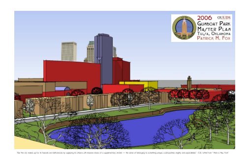
“But the city makes up for its hazards and deficiencies by supplying its citizens with massive doses <strong>of</strong> a supplementary vitamin — the sense <strong>of</strong> belonging to something unique, cosmopolitan, mighty and unparalleled.” - E.B. White from “ Here is New York”
The <strong>University</strong> <strong>of</strong> <strong>Oklahoma</strong><br />
<strong>Graduate</strong> <strong>College</strong><br />
2006 <strong>Gunboat</strong> <strong>Park</strong> Master <strong>Plan</strong><br />
A Pr<strong>of</strong>essional Project<br />
submitted to the <strong>Graduate</strong> Faculty<br />
in partial fullfillment <strong>of</strong> the requirements for the Degree <strong>of</strong><br />
Master <strong>of</strong> Science in Architectural Urban Studies<br />
by<br />
Patrick McDonald Fox<br />
<strong>Tulsa</strong>, <strong>Oklahoma</strong><br />
2006<br />
Approved for the Urban Design Studio<br />
<strong>of</strong><br />
The <strong>College</strong> <strong>of</strong> Architecture<br />
by<br />
Shawn Michael Schaefer, Chair<br />
Hans Butzer<br />
Roger Randle<br />
©Copyright by Patrick M. Fox 2006<br />
All Rights Reserved
Table <strong>of</strong> Contents<br />
Acknowledgements<br />
Preface and <strong>Plan</strong>ning Framework<br />
<strong>Plan</strong>ning Process<br />
Location Maps<br />
Aerial Photo <strong>of</strong> Downtown <strong>Tulsa</strong> and <strong>Gunboat</strong> <strong>Park</strong><br />
Base Map<br />
<strong>Gunboat</strong> <strong>Park</strong> Plat and Atlas Map<br />
Sanborn Maps<br />
History <strong>of</strong> <strong>Plan</strong>ning in <strong>Gunboat</strong> <strong>Park</strong><br />
Existing Conditions: Models<br />
Existing Conditions: Sketch Up Model<br />
Existing Conditions: Photographs<br />
Urban Design Process<br />
KMO District and Development Map<br />
<strong>Gunboat</strong> <strong>Park</strong> District Overlay Map<br />
<strong>Gunboat</strong> <strong>Park</strong> Master <strong>Plan</strong><br />
<strong>Gunboat</strong> <strong>Park</strong> Master <strong>Plan</strong> Zoom<br />
<strong>Gunboat</strong> <strong>Park</strong> Master <strong>Plan</strong> without Notes<br />
<strong>Gunboat</strong> <strong>Park</strong> Massing Model (Proposed)<br />
Eleventh Street Corridor: Streetscape<br />
Eleventh Street Corridor: New Office/Retail Development<br />
Eleventh Street Corridor: Bus Stop<br />
10th and Elgin Intersection Enhancements<br />
South Detroit Retail Corridor<br />
South Detroit Retail Corridor: Visualization<br />
South Detroit Retail Corridor: Hotel and Office Cluster<br />
Eleventh Place Street Realignment<br />
<strong>Gunboat</strong> <strong>Park</strong> L<strong>of</strong>t District: Overview<br />
<strong>Gunboat</strong> <strong>Park</strong> L<strong>of</strong>t District: <strong>Park</strong> Enhancements and Flood Detention<br />
<strong>Gunboat</strong> <strong>Park</strong> L<strong>of</strong>t District: Frankfort Avenue<br />
<strong>Gunboat</strong> <strong>Park</strong> L<strong>of</strong>t District: Elgin Street Rowhouses<br />
<strong>Gunboat</strong> <strong>Park</strong> L<strong>of</strong>t District: South <strong>Gunboat</strong> Residential<br />
Summary and Implementation Strategy<br />
Bibliography<br />
4<br />
5<br />
6<br />
7<br />
8<br />
9<br />
10<br />
11<br />
12<br />
13<br />
14<br />
15<br />
16<br />
17<br />
18<br />
19<br />
20<br />
21<br />
22<br />
23<br />
24<br />
25<br />
26<br />
27<br />
28<br />
29<br />
30<br />
31<br />
32<br />
33<br />
34<br />
35<br />
36<br />
37
Acknowledgements<br />
This project is dedicated to my wife, Katie, for her support and patience.<br />
I love you.<br />
And to my son for whom I wait with bated breath.<br />
I love you too.<br />
Thanks to Mom, Dad, and Lori for being there when I needed moral and other (food, lodging, and cha-ching!) support.<br />
Seriously, I could not have done this without you all.<br />
Thanks to everyone else who helped and supported me along the way: Roger Randle, Hans Butzer, Pat Treadway, Tom Baker,<br />
Bruce Bozle, Dr. Jack Crowley, Ann Crowley, Sarah Fox, Lindsey Fox, Chuck and Irene McConville, Steve Carr, Theron<br />
Warlick, Monty McElroy, David Simmons, Amanda DeCort, Jim Coles, Pr<strong>of</strong>essor Goins, Duane Cuthbertson, Ron Flanagan,<br />
Greg Pollard, Paul Coury, Ryon Stirling, Ed Sharrer and anyone else I’ve bored to death with all <strong>of</strong> my planning “junk”.<br />
Thanks to my classmates: Marcus Fairless, Dr. Tom Costner, & Ryan Nowlin.<br />
Special thanks to Shawn Schaefer for his wisdom and guidance. (And for not letting me quit.)
Preface and <strong>Plan</strong>ning Framework<br />
The conclusion <strong>of</strong> the 2005 Tracy <strong>Park</strong> + <strong>Gunboat</strong> <strong>Park</strong> Master plan stated:<br />
“...in the end, Tracy and <strong>Gunboat</strong> <strong>Park</strong>s will adapt to change and grow positively with that change, that they will<br />
provide safety and comfort to it’s residents; and that they become and remain vital for decades to come.”<br />
The purpose for following up this study less than one year later with another academic planning project is to ensure that<br />
the goals listed above move forward toward implementation and reality. While the 2005 study focused largely on data<br />
and research gathered from various sources, none more important than from the people who live and work in <strong>Gunboat</strong><br />
and Tracy <strong>Park</strong>s, it also contained some recommendations for future development. While Tracy <strong>Park</strong> residents were<br />
more concerned about safety commercial encroachment, <strong>Gunboat</strong> <strong>Park</strong> and other areas within the inner dispersal loop<br />
were particularly targeted for revitalization and new investment. Some the boldest recommendations came within the<br />
boundaries <strong>of</strong> the original Elm <strong>Park</strong> plat.<br />
With the 2005 study, the <strong>University</strong> <strong>of</strong> <strong>Oklahoma</strong> Urban Design Studio studied the two neighborhoods in conjunction with<br />
each other because they felt strongly that the problems they were facing were linked. The assumptions proved to be<br />
true, and the subsequent recommendations resulted from that vein <strong>of</strong> thought. As the recommendations emerged, it<br />
became clear however, that what was recommended for <strong>Gunboat</strong> <strong>Park</strong> was very different than what was recommended<br />
for Tracy <strong>Park</strong>. So, in 2006 as the planning process started up again, it was only natural to take a new approach to<br />
planning for the area.<br />
The <strong>Gunboat</strong> <strong>Park</strong> recommendations were formulated from unique circumstances. First, the typical resident <strong>of</strong> the<br />
neighborhood rents an apartment or a room in a multi-family structure, as opposed to owning a single family home.<br />
Second, <strong>Gunboat</strong> being located within the IDL, is subject to Central Business District (CBD) zoning, which in essence,<br />
<strong>of</strong>fered few restrictions on use, height, setback, or parking. Third, <strong>Gunboat</strong> <strong>Park</strong> was particularly susceptible to flooding,<br />
which was an issue for physical reinvestment in the area. Lastly, there were a variety <strong>of</strong> social issues which also<br />
discouraged reinvestment, and caused a number <strong>of</strong> safety concerns in the neighborhoods, which also discourage<br />
investment in the district.<br />
Several other planning efforts have also provided the framework for this project, including the Infill Development Task<br />
Force, The Sixth Street Infill <strong>Plan</strong>, The Elm Creek Master Drainage <strong>Plan</strong> and the Brady Village Infill Development <strong>Plan</strong>.<br />
The desire is that through this process, the recommendations presented in this plan will continue to evolve and,<br />
eventually, come to fruition.<br />
Project Schedule<br />
Tracy <strong>Park</strong> + <strong>Gunboat</strong> <strong>Park</strong><br />
3<br />
5
<strong>Plan</strong>ning Process<br />
The planning process for this project began in the Fall <strong>of</strong> 2004 with a series <strong>of</strong> community meetings, a visual and written survey,<br />
several observational exercises, and 6 months worth <strong>of</strong> data collection and mapping. The synthesis <strong>of</strong> this data began in the<br />
Spring <strong>of</strong> 2005 and has continued today.<br />
Continued partnerships with key interests in the neighborhood have been pivotal in this process. I have been fortunate enough to<br />
have several partners in this effort. KMO Development, a real estate development firm with several assets in the area has been<br />
willing to share ideas and plans to see this project through to fruition. The City <strong>of</strong> <strong>Tulsa</strong> Urban Development Department has<br />
provided this project with real and moral support, from providing maps and data, to facilitating meetings with the neighborhoods.<br />
Former District 4 Councilor Tom Baker was also instrumental in setting up meetings I would not have otherwise been able to<br />
arrange on my own. Lastly, the residents and business owners <strong>of</strong> <strong>Gunboat</strong> <strong>Park</strong> deserve much credit for their participation<br />
throughout the process<br />
The design phase would not have been possible without all <strong>of</strong> these people. This plan will <strong>of</strong>fer clearer design and more specific<br />
recommendations for <strong>Gunboat</strong> <strong>Park</strong> and its surroundings based largely on the information gathered in the first year and a half <strong>of</strong><br />
the planning process.<br />
The last phase, which this plan addresses in general, is the prioritization, strategy and implementation phase. This phase, more<br />
than any other, requires the will and participation <strong>of</strong> the people if any <strong>of</strong> the recommendations in this plan are to move forward.<br />
6
<strong>Gunboat</strong> <strong>Park</strong> Location Maps<br />
Downtown <strong>Tulsa</strong>, <strong>Oklahoma</strong><br />
Maps courtesy <strong>of</strong> Downtown <strong>Tulsa</strong> Unlimited<br />
<strong>Gunboat</strong> <strong>Park</strong> is located in the southeastern<br />
corner <strong>of</strong> <strong>Tulsa</strong>’s Central Business<br />
District.<br />
7
Aerial Photo <strong>of</strong> Downtown <strong>Tulsa</strong> and <strong>Gunboat</strong> <strong>Park</strong><br />
During the last five decades <strong>Tulsa</strong>,<br />
like many cities in the United<br />
States, has experienced a gradual<br />
decline in sheer numbers <strong>of</strong><br />
buildings in its downtown core<br />
There are many factors that can be<br />
attributed to this trend, but no one<br />
more significant than the<br />
proliferation <strong>of</strong> the automobile.<br />
A number <strong>of</strong> geographic and anthropological issues can be related to the<br />
West’s dependence on the automobile. Included in that category is the<br />
increased physical need for parking and the expanding geographic and<br />
human boundaries <strong>of</strong> our nation’s cities. The exodus <strong>of</strong> residents from the<br />
city core is partially driven by the use <strong>of</strong> cars and trucks as the primary<br />
source <strong>of</strong> transportation for the majority <strong>of</strong> <strong>Tulsa</strong>ns and Americans as a<br />
whole.<br />
The pressure to provide parking for downtown employees and shoppers in<br />
<strong>Tulsa</strong>’s downtown retail district began the teardown trend in the 1940s and<br />
50’s. The linear growth pattern <strong>of</strong> the city and continued suburbanization <strong>of</strong><br />
<strong>Tulsa</strong>’s residential areas eventually subsidized the success <strong>of</strong> the suburban<br />
shopping center. This eventually drove most retail establishments out <strong>of</strong><br />
downtown <strong>Tulsa</strong>. As these business emptied the buildings they once<br />
occupied, it became common for property owners to tear down a building for<br />
a parking lot rather than maintain the older buildings. This cycle continues<br />
today as there have been five major teardowns in downtown <strong>Tulsa</strong> within the<br />
past one and a half years.<br />
The aerial to the left displays this trend. It is particularly noticeable in the<br />
south end <strong>of</strong> downtown near <strong>Gunboat</strong> <strong>Park</strong>. <strong>Gunboat</strong> <strong>Park</strong> itself has been<br />
largely spared from this trend until recently.<br />
Aerial courtesy <strong>of</strong> the City <strong>of</strong> <strong>Tulsa</strong>. Photgraph in upper right corner courtesy <strong>of</strong> the Beryl Ford Collection. 8
Base Map<br />
This map displays the boundaries <strong>of</strong> the original Tracy<br />
<strong>Park</strong> + <strong>Gunboat</strong> <strong>Park</strong> study, as well as providing building<br />
and vegetaion locations. <strong>Gunboat</strong> <strong>Park</strong> is located the the<br />
west <strong>of</strong> the highway.<br />
9
<strong>Gunboat</strong> <strong>Park</strong> Plats and Atlas Maps<br />
<strong>Gunboat</strong> <strong>Park</strong> was originally platted as and is still referred to legally Elm <strong>Park</strong> in<br />
1917. The map to the left is a copy <strong>of</strong> the original plat.<br />
Below is from the City <strong>of</strong> <strong>Tulsa</strong> atlas. Both maps show that <strong>Gunboat</strong>’s unique shape<br />
has maintained its original form for nearly 80 years.<br />
Documents provided by City <strong>of</strong> <strong>Tulsa</strong> Urban Development Department.<br />
10
Sanborn Fire Insurance Maps<br />
Mapped from 1926 through 1939<br />
Maps: Sanborn Library LLC<br />
http://sanborn.umi.com 11
History <strong>of</strong> <strong>Plan</strong>ning<br />
in <strong>Gunboat</strong> <strong>Park</strong><br />
Throughout the history <strong>of</strong> planning in<br />
downtown <strong>Tulsa</strong>, <strong>Gunboat</strong> <strong>Park</strong> has been<br />
identified as a unique area within the<br />
Inner Dispersal Loop. While design<br />
solutions for <strong>Gunboat</strong> and Downtown<br />
have varied in style and design, there are<br />
several concepts that are constant in<br />
most every plan:<br />
1) The need to mitigate flooding in <strong>Gunboat</strong><br />
through detention facilities along the<br />
Elm Creek drainage basin.<br />
2) Recommending higher density residential<br />
as the primary appropriate use<br />
within <strong>Gunboat</strong> <strong>Park</strong> area.<br />
3) Retention and rehabilitation <strong>of</strong> key<br />
structures in the area.<br />
4) Office and retail, mixed use development.<br />
5) Intersection and streetscape improvements,<br />
primarily at the 10th and Elgin<br />
intersection.<br />
Images courtesy <strong>of</strong> Downtown <strong>Tulsa</strong> Unlimited<br />
12
Existing Conditions: Modeling <strong>Gunboat</strong><br />
A physical, scaled model built both<br />
for displaying existing conditions<br />
and also for experimenting with<br />
potential urban design solutions.<br />
Many <strong>of</strong> the recommendations<br />
emerged from this process.<br />
13
Existing Conditions<br />
Sketch Up Model<br />
The initial Sketch-Up model <strong>of</strong> <strong>Gunboat</strong><br />
<strong>Park</strong> was designed to depict the<br />
existing building massing in the study<br />
area. It was used as the base design<br />
tool for the final <strong>Gunboat</strong> <strong>Park</strong> Master<br />
<strong>Plan</strong>.<br />
14
Existing Conditions<br />
Photographs<br />
15
Design Process<br />
The physical design process began in earnest in early 2006 by identifying<br />
broad, distinct districts, and determining their current function and potential<br />
function in a revitalized downtown core. Upon identifying those district, we<br />
examined more specific conditions such as traffic dispersion, and the<br />
emersion <strong>of</strong> potential destination sites within downtown, and how the<br />
existing street pattern might influence the success <strong>of</strong> a specific area.<br />
The images to the left and the right <strong>of</strong> the page display different stages in<br />
the design process. One <strong>of</strong> the most difficult problems encountered was<br />
the intersection at 10th and Detroit. The three images to the left show<br />
different concepts for routing traffic through the intersection, while trying to<br />
make pedestrian crossings a safe as possible. Ultimately, we wanted to<br />
make the intersection a focal point and use it as an amenity. Thus, we<br />
determined that a traffic circle was the most effective way to safely route<br />
traffic through the intersection, while providing an attractive feature for<br />
pedestrians and cyclists to utilize.<br />
16
Private Development<br />
KMO <strong>Gunboat</strong> <strong>Park</strong>/South End <strong>Plan</strong><br />
Neighborhood revitalization requires both public and private<br />
investment. Since the 2005 Tracy + <strong>Gunboat</strong> <strong>Park</strong> Master <strong>Plan</strong>, the<br />
areas immediately surrounding <strong>Gunboat</strong> <strong>Park</strong> have seen private<br />
investment in both buildings and land. In 2005 the KMO Development<br />
Group completed a renovation <strong>of</strong> the Norton Isuzu car dealership for<br />
potential restaurant or retail space, and a conversion <strong>of</strong> the<br />
dealership’s service bay into <strong>of</strong>fice space, and it now operates as<br />
KMO’s home <strong>of</strong>fice. 100 employees currently work in this adaptive<br />
reuse within two blocks <strong>of</strong> the original <strong>Gunboat</strong> Study area.<br />
Additionally, KMO purchased the Sunoco Oil Building in early 2006 with<br />
intentions <strong>of</strong> moderizing its <strong>of</strong>fice space.<br />
The plan to the left, produced by KMO and Selser-Schaefer Architects,<br />
represents one concept for additional development in the <strong>Gunboat</strong><br />
District. Concepts <strong>of</strong> this plan, including additional housing, retail along<br />
11th street, a traffic circle at 11th and Elgin, and a 190 room hotel;<br />
concepts that are carried through in the final iteration <strong>of</strong> this plan.<br />
17
<strong>Gunboat</strong> <strong>Park</strong> District Overlay Map<br />
The <strong>Gunboat</strong> <strong>Park</strong> District, which has sometimes been<br />
referred to as Elm <strong>Park</strong>, has long been identified as an<br />
independent and unique place in Downtown <strong>Tulsa</strong>. This<br />
overlay identifies several potential development areas<br />
and districts in and around <strong>Gunboat</strong>.<br />
North <strong>of</strong> the <strong>Gunboat</strong> District is the East Village, an area<br />
east <strong>of</strong> the Downtown Core which has been identified for<br />
potential mixed use development. Of note, this area is a<br />
possible site for a minor league baseball stadium.<br />
To the west and northwest <strong>of</strong> <strong>Gunboat</strong> are Cathedral<br />
Square and the Downtown Core respectively.<br />
Between Cathedral Square and <strong>Gunboat</strong>, <strong>Tulsa</strong><br />
Community <strong>College</strong> owns several square blocks. No<br />
plans were immediately available identifying future<br />
campus development.<br />
Within the <strong>Gunboat</strong> District there are several distinct<br />
areas: 1) The <strong>Gunboat</strong> <strong>Park</strong> L<strong>of</strong>t/Residential District, 2)the<br />
South Detroit Retail Corridor, 3) The KMO Blocks<br />
(planned development by KMO Development Corp. 4)<br />
Home Depot/Warehouse Market Site, 5) <strong>Park</strong>ing areas,<br />
and 6) the 11 & 11th Node.<br />
The location for the proposed South Detroit<br />
retail corridor.<br />
18
<strong>Gunboat</strong> <strong>Park</strong> Master <strong>Plan</strong><br />
The <strong>Gunboat</strong> <strong>Park</strong> Master <strong>Plan</strong> as shown to the left is the visual<br />
culmination <strong>of</strong> months <strong>of</strong> research, collecting community input, analysis<br />
<strong>of</strong> opportunities, and finally, formulation <strong>of</strong> design. The process was<br />
designed to ensure both that community concerns were properly<br />
considered and the resulting urban design would create a vibrant and<br />
safe environment.<br />
As depicted in the district overlay map on page 18, the <strong>Gunboat</strong> area has<br />
several distinct sub districts. Because these districts are geographically<br />
adjacent to each other, there is great potential for creating a true 24/7<br />
environment within a small area. Combined these districts can provide<br />
a variety <strong>of</strong> amenities and services; places to work, places to live, places<br />
to shop, places to play, and places to eat; all within an easily walkable<br />
urban environment.<br />
Because this district is located within the Inner Dispersal Loop, and the<br />
properties in question are zoned CBD, it <strong>of</strong>fers some opportunities to<br />
combine these uses without many <strong>of</strong> the restrictions that exist with<br />
properties outside the IDL.<br />
There was also an identified need for some capital investment in the<br />
district. Streetscape and intersection improvements along Detroit and<br />
particularly along 11th Street, would provide needed infrastructure for<br />
emerging private development. There is also an identified need for<br />
downstream flood relief as part <strong>of</strong> the Elm Creek Master Drainage <strong>Plan</strong>.<br />
The proposed stormwater retention pond at the north end <strong>of</strong> <strong>Gunboat</strong><br />
<strong>Park</strong> would help to provide flood relief and present an attractive focal<br />
point for the <strong>Gunboat</strong> <strong>Park</strong> Neighborhood.<br />
19
<strong>Gunboat</strong> <strong>Park</strong> Master <strong>Plan</strong><br />
Zoom Version<br />
20
Master <strong>Plan</strong> (without notes)<br />
21
<strong>Gunboat</strong> <strong>Park</strong> Massing Model<br />
22
Eleventh Street Corridor<br />
Streetscape & New Office/Retail Development<br />
Eleventh Street Proposals:<br />
· Street, Sidewalk, Curbline, and<br />
Landscape Improvements<br />
o Traffic Circle with Monument/Art<br />
for Route 66, 1921 Race Riot, or<br />
McNulty <strong>Park</strong><br />
o Curb to Curb street repair.<br />
o Parallel parking and bump outs on<br />
South side <strong>of</strong> street.<br />
o Boulevard Treatment.<br />
o Trees/Vegetation in boulevard.<br />
o Terraced Landscaping on<br />
Greenbelt north <strong>of</strong> 11 th Street.<br />
o Covered Bus Stop at 11 th and<br />
Frankfort, North and South sides<br />
<strong>of</strong> street.<br />
o Cut in for busses on North side <strong>of</strong><br />
street.<br />
Private Development<br />
o Mixed use <strong>of</strong>fice retail on South<br />
side <strong>of</strong> street. 90000 Sq. ft <strong>of</strong><br />
proposed mixed use on 11 th<br />
between traffic circle and<br />
overpass. 2-4 stories.<br />
o Proposed 200,000 Sq. ft./11 story<br />
<strong>of</strong>fice Building at 11 th & Detroit.<br />
o Proposed 6000 Sq. ft pad site in<br />
front <strong>of</strong> Home Depot.<br />
o 10-12 ft Sidewalk setbacks.<br />
23
Eleventh Street Corridor<br />
Streetscape & New Office/Retail Development<br />
Left : 11th Street Improvements as seen from<br />
the air lookings south.<br />
Below: Photographs <strong>of</strong> 11th Street as it exists<br />
today.<br />
24
Bus Stop<br />
Photo courtesy <strong>of</strong> the Bus Stops Here project.<br />
http://www.the-bus-stops-here.org/Union_City-NB_Dyer_Opp_Rankin-Shelter-s.jpg<br />
Proposed new covered bus stops and transfer station on<br />
the north side <strong>of</strong> 11th at Frankfort.<br />
In urban districts, public transportation provides<br />
convenient and inexpensive alternatives to driving and<br />
parking. The current stop at this location does not have a<br />
bench or a safe transfer point. The cut in provides a bus<br />
only lane which removes the bus from main flow <strong>of</strong> traffic,<br />
making it safer for riders and drivers. Modern busses with<br />
disability access lifts and bicycle racks take longer to load<br />
and unload, and can impede traffic when stopped in the<br />
street.<br />
25
10th and Elgin Intersection Enhancements<br />
The 10 th & Elgin intersection is one <strong>of</strong> the most interesting Downtown<br />
<strong>Tulsa</strong>. Elgin Avenue, 11 th Street (historic Route 66), 10 th Street and 11 th<br />
Place intersect at an “S” curve which is also on a slight grade to the<br />
west. The current configuration is difficult to navigate, and has been<br />
identified for some time by the City <strong>of</strong> <strong>Tulsa</strong> traffic engineering<br />
department for improvement. The intersection has also been identified<br />
as a potential project to be paid for with Central <strong>Park</strong> TIF funds.<br />
The traffic circle, in conjunction with the 11 th Place realignment (page<br />
30), is designed as both a solution to the engineering problem and<br />
also as an amenity. The circle and the surrounding plaza areas<br />
diagrammed to the left are designed to improve the visual appearance<br />
<strong>of</strong> the intersection and to create pedestrian space.<br />
Tenth and Elgin is known to most as the location <strong>of</strong> the art deco<br />
Warehouse Market and the entrance point for Route 66 into Downtown<br />
<strong>Tulsa</strong>. Prior to its construction in the 1930’s, it was also the location <strong>of</strong><br />
McNulty <strong>Park</strong>, which has the distinction <strong>of</strong> being one <strong>of</strong> <strong>Tulsa</strong>’s earliest<br />
baseball parks. It was also one <strong>of</strong> the internment locations for African-<br />
American detainees during the 1921 Race Riot. Any <strong>of</strong> these<br />
distinctions would be worthy <strong>of</strong> commemorating, and the new design<br />
<strong>of</strong>fers several sites for locating such a memorial or piece <strong>of</strong> art.<br />
26
South Detroit Retail Corridor<br />
Detroit Avenue is a primary vehicular entrance point for downtown <strong>Tulsa</strong> from the Broken Arrow Expressway. Likewise,<br />
Cincinnati Avenue one block to the west, and which forms the western edge <strong>of</strong> the planning district, is the primary route for<br />
downtown workers leaving the Central Business District. The corridor’s proximity to these two paths provides a high amount<br />
<strong>of</strong> visibility and convenience for these travelers.<br />
<strong>Tulsa</strong> Community <strong>College</strong> and Boston Avenue Methodist Church to the west and the emerging residential district in <strong>Gunboat</strong><br />
and Tracy <strong>Park</strong>s to the East also provide a more captive<br />
The existing building stock is varied. The southernmost Downtown blocks are primarily made up <strong>of</strong> plains commercial<br />
storefronts and garages, a typical building style <strong>of</strong> the 1920’s and 1930’s. The buildings are primarily being used for light<br />
industrial and auto repair, however they <strong>of</strong>fer great opportunity for adaptive reuse in an retail or restaurant capacity.<br />
The building stock becomes more varied and sparse as Detroit travels north into downtown, exposing a number <strong>of</strong><br />
opportunity sites for new development. Preferred development involves mixed uses: first floor retail, second story<br />
pr<strong>of</strong>essional <strong>of</strong>fice, and upper floor residential. This plan displays a variety <strong>of</strong> options for mixed use development<br />
There was also an identified need for a number <strong>of</strong> residential units adjacent to <strong>Tulsa</strong> Community <strong>College</strong>. A proposed 120<br />
unit complex is located at 10th and Detroit<br />
The North end <strong>of</strong> the corridor features an <strong>of</strong>fice cluster. The 12 story Sun oil Building and a proposed 200,000 square foot<br />
11 story <strong>of</strong>fice building are serviced by a 1500 space parking garage located at 10th and Elgin.<br />
The most noticeable change to the skyline is a 21 story 195 room hotel. The height also allows for approximately 20<br />
penthouse condominium units. The hotel would feature a number <strong>of</strong> amenities, including restaurant, meeting space, and<br />
spa, which would be available to guests and residents.<br />
27
South Detroit Retail Corridor<br />
28
South Detroit Retail Corridor<br />
Hotel and Office Cluster<br />
Above: The current skyline at 10th and Elgin<br />
Below: Retail and Office in DowntownPortland, Oregon<br />
29
South Detroit/Eleventh Place Street Realignment<br />
The 11 th Place realignment is the result <strong>of</strong> an design process<br />
which evaluated the existing physical alignment <strong>of</strong> 11 th Place,<br />
the difficult to navigate intersection at 10 th and Elgin, the<br />
current traffic conditions, the potential for increased future<br />
traffic downtown, balanced with the desire to create an<br />
intimate, more appealing environment that would attract<br />
mixed-ues development.<br />
The result creates several opportunity sites for future<br />
development and a pedestrian friendly “plaza” area<br />
surrounding the proposed traffic circle. The ‘Y’ shaped<br />
intersection increases the potential retail frontage space<br />
along the realigned 11 th Place, and places a new entry point<br />
for the street at the intersection. The metered traffic circle is<br />
designed to help navigate this intersection. The ‘Y’ also<br />
creates an interesting triangle shaped space that could be<br />
filled by a new iconic “flatiron” building, which creates a<br />
dramatic approach traveling North on Denver.<br />
Above: 11th Place as it is today.<br />
30
<strong>Gunboat</strong> <strong>Park</strong> L<strong>of</strong>t District<br />
Overview<br />
<strong>Gunboat</strong> <strong>Park</strong> in its current condition is a neighborhood <strong>of</strong><br />
mixed uses, <strong>of</strong>ten incompatible with each other. There are<br />
liquor stores, apartments, light industrial businesses,<br />
distribution warehouses, and single family homes all<br />
abutting each other. Crime and safety are still major<br />
concerns in the neighborhood, so during the planning and<br />
design process these were the issues we were<br />
attempting to address.<br />
<strong>Gunboat</strong> <strong>Park</strong> has been identified as a residential first<br />
neighborhood since it was established in 1917. CBD<br />
zoning has permitted the continued clash <strong>of</strong> land-use<br />
interests in the neighborhood. Additionally, our research<br />
and observations were that the persistence <strong>of</strong> criminal<br />
activity was due to the lack <strong>of</strong> attention the perpetrators<br />
were given at this location.<br />
The logical conclusion we came to, is that in order to<br />
resolve the social, and land-use issues, <strong>Gunboat</strong> <strong>Park</strong><br />
needed to repopulate itself. The biggest deterrent for<br />
crime is to have “eyes on the street” as <strong>of</strong>ten as possible.<br />
In order to create that environment, <strong>Gunboat</strong> <strong>Park</strong> needed<br />
to return to its residential roots. The added benefit would<br />
be that, if <strong>Gunboat</strong> was to become residential again, it<br />
might capitalize on the current trends being seen around<br />
the country in terms <strong>of</strong> housing type and lifestyle choices.<br />
The creation <strong>of</strong> a distinct “L<strong>of</strong>t District” centered around a<br />
unique outdoor space, would create an attractive living<br />
environment for anyone who desires a more urban<br />
lifestyle, from Young Pr<strong>of</strong>essionals to “empty nesters”.<br />
The influx <strong>of</strong> residents into the district would be the<br />
catalyst for growth and infill in the southeastern quadrant<br />
<strong>of</strong> Downtown <strong>Tulsa</strong>.<br />
Left: Proposed <strong>Gunboat</strong> L<strong>of</strong>t District<br />
Lower left: L<strong>of</strong>ts in the Pearl District, Portland,<br />
Oregon<br />
Below: East Elgin Avenue, <strong>Gunboat</strong> <strong>Park</strong><br />
31
<strong>Gunboat</strong> L<strong>of</strong>t District:<br />
<strong>Park</strong> Enhancements and Stormwater Detention Pond<br />
<strong>Gunboat</strong> <strong>Park</strong> has been identified by the Elm Creek Master Drainage <strong>Plan</strong> as one <strong>of</strong> the developed<br />
neighborhoods along Elm Creek that is susceptable to flooding. While the construction <strong>of</strong><br />
the upstream detention ponds at Centennial <strong>Park</strong> mitigate much <strong>of</strong> the potential flooding in <strong>Gunboat</strong>,<br />
it doescorrect flooding downstream towards South Boston and Veteran’s <strong>Park</strong>. The construction<br />
<strong>of</strong> a pond at <strong>Gunboat</strong> would assist in mitigating this flooding while providing an attractive<br />
public amenity. The removal <strong>of</strong> the industrial uses in the neighborhood and the expansion <strong>of</strong><br />
the park would provide added incentive for residental redevelopment in the neighborhood.<br />
32
<strong>Gunboat</strong> <strong>Park</strong> L<strong>of</strong>t District<br />
East <strong>Gunboat</strong> <strong>Park</strong>/ Frankfort Avenue L<strong>of</strong>ts<br />
As mentioned on page 31, <strong>Gunboat</strong> <strong>Park</strong> should provide a variety <strong>of</strong> urban housing options. The west side <strong>of</strong> <strong>Gunboat</strong> along Frankfort is an appropriate site for<br />
urban-styled work/live l<strong>of</strong>ts. This plan proposes the conversion <strong>of</strong> the art deco Better Price Warehouse plus new construction to provide an additional 100 to 120<br />
l<strong>of</strong>t units. These buildings would typically be 3 to 4 stories to provide a buffer from the highway noise for the interior <strong>of</strong> <strong>Gunboat</strong> <strong>Park</strong>. The l<strong>of</strong>ts themselves<br />
would provide flexible space for urban pr<strong>of</strong>essionals, artists, at home businesses, or empty nesters. This location provides spectacular views <strong>of</strong> the current<br />
<strong>Tulsa</strong> skyline and the proposed area improvements. The desired result is the creation <strong>of</strong> a dense, walkable environment with easy access to public<br />
transportation, outdoor recreation, and convenient amenities.<br />
33
<strong>Gunboat</strong> <strong>Park</strong> L<strong>of</strong>t District<br />
West <strong>Gunboat</strong>/East Elgin Townhomes<br />
The west side <strong>of</strong> the <strong>Gunboat</strong> L<strong>of</strong>t District, along Elgin Avenue provides an<br />
opportunity for an equally urban, yet smaller scaled type <strong>of</strong> housing. The<br />
west side <strong>of</strong> <strong>Gunboat</strong>, with it’s narrow street and large shade trees,<br />
provides a more typical neighborhood experience. A multistory urban<br />
house, two to three stories, attached or detached, that is built close to the<br />
street and has an individual entrance and private outdoor space more<br />
typical <strong>of</strong> a single family home is appropriate for this site.<br />
Depicted in this plan are two story townhouses, approximately 1500<br />
square feet a piece. These promote the visual appearance <strong>of</strong> density<br />
while providing another housing option within the <strong>Gunboat</strong> neighborhood.<br />
Combined with the existing walk-up apartments, single family homes, and<br />
the proposed l<strong>of</strong>t style apartments, <strong>Gunboat</strong> <strong>Park</strong> should <strong>of</strong>fer a broad<br />
range <strong>of</strong> housing options within a very small area.<br />
Rowhouses in Minneapolis.<br />
Photo by Patrick Fox<br />
Homes on Elgin. Most <strong>of</strong><br />
these houses have been<br />
condemned or torn down.<br />
Photo by Patrick Fox<br />
34
<strong>Gunboat</strong> <strong>Park</strong> L<strong>of</strong>t District<br />
South <strong>Gunboat</strong><br />
South <strong>Gunboat</strong> <strong>Park</strong> has seen more private investment in its older structures than the<br />
rest <strong>of</strong> the neighborhood. As a result the existing housing, consisting primarily <strong>of</strong><br />
classicly styled walk up apartments and historic single family homes, is in relatively<br />
good condition. Furthermore this type <strong>of</strong> housing provides a more moderately priced<br />
alternative to new, higher end construction. In conclusion, the plan calls for the<br />
preservation <strong>of</strong> these structures.<br />
There are a few opportunity sites where either the structure is in extremely poor<br />
condition or where there is no structure. The proposal is to add housing which<br />
complements the existing structures in style and scale. On Frankfort, housing should<br />
be l<strong>of</strong>t style, scaled to the Better Price Warehouse. On East 12 th , appropriate infill<br />
would be walk up style apartments designed complement the existing architecture,<br />
and to take advantage <strong>of</strong> the new views provided by the expanded park and pond.<br />
The south side <strong>of</strong> East 13 th and <strong>Gunboat</strong>, the plan proposes row houses similar to<br />
those on Elgin.<br />
One problematic site is the location <strong>of</strong> the cell tower on Frankfort. The optimum<br />
solution for the neighborhood would be for the removal <strong>of</strong> the tower. At street level, it<br />
requires a safety fence which is visually inconsistent with the rest <strong>of</strong> the<br />
neighborhood. On a larger scale, the tower obstructs the visual pattern <strong>of</strong> the<br />
neighborhood due to its tremendous height. A short term alternative is to adorn the<br />
tower and its site with landscaping and art.<br />
35
Summary and Implementation Strategy<br />
Seeing the <strong>Gunboat</strong> <strong>Park</strong> Master <strong>Plan</strong> move from the page to reality will require a strong public and private<br />
partnership and the effort and time <strong>of</strong> nearly every person affected by this plan. The importance <strong>of</strong> these<br />
relationships is that the needs <strong>of</strong> on affects the other and vice versa.<br />
There are current identified capital needs in the area already: Elm Creek flood control and 10 th and Elgin street<br />
improvements. The importance <strong>of</strong> this plan is that it may help dictate how those capital improvements are<br />
implemented.<br />
There has already been significant investment from the private community. In downtown alone the last three<br />
months <strong>of</strong> 2005 and the first three months <strong>of</strong> 2006 witness around 200 million dollars worth <strong>of</strong> real estate<br />
transactions. These are all indicators <strong>of</strong> positve change in Downtown <strong>Tulsa</strong> and this, <strong>of</strong> course, is a positive<br />
sign for <strong>Gunboat</strong> <strong>Park</strong>.<br />
Outside <strong>of</strong> Downtown, Tracy <strong>Park</strong> and the Sixth Street are seeing a revival <strong>of</strong> sorts, as an energized community<br />
continues to put forth effort into bettering their neighborhoods. This too bodes well for <strong>Gunboat</strong> <strong>Park</strong>.<br />
First and foremost, <strong>Gunboat</strong> <strong>Park</strong> must form an orgaized and active neighborhood association. Second, this<br />
plan needs to be refined, revised, expanded, detailed, and adopted in to the City <strong>of</strong> <strong>Tulsa</strong> District 1<br />
Comprehensive <strong>Plan</strong>.<br />
Like the 2005 plan, this is not a final document. There will be more community meetings. There will be new<br />
ideas and changes to the plan. I look forward to being there when it happens,<br />
Patrick M. Fox<br />
36
Bibliography & Resources<br />
Books & Reports:<br />
2005 Tracy <strong>Park</strong> + <strong>Gunboat</strong> <strong>Park</strong> Master <strong>Plan</strong>. <strong>University</strong> <strong>of</strong> <strong>Oklahoma</strong> Urban Design Studio, <strong>Tulsa</strong>, <strong>Oklahoma</strong>. The <strong>University</strong> <strong>of</strong><br />
<strong>Oklahoma</strong>, 2005.<br />
Brady Village Infill Development Guidelines. Brady Village Infill Task Force & the City <strong>of</strong> <strong>Tulsa</strong>, OK, 2004.<br />
Brookside Infill Neighborhood Detailed Implementation <strong>Plan</strong>. Brookside Infill Task Force & the City <strong>of</strong> <strong>Tulsa</strong>, OK, 2005.<br />
Central <strong>Park</strong> Tax Increment District No. Two Project <strong>Plan</strong>. City <strong>of</strong> <strong>Tulsa</strong>, OK, 1994.<br />
The Downtown Master <strong>Plan</strong> 1989 -2009 <strong>Tulsa</strong> <strong>Oklahoma</strong>. Downtown Master <strong>Plan</strong> Task Force, Prepared for Downtown <strong>Tulsa</strong><br />
Unlimited & The City <strong>of</strong> <strong>Tulsa</strong>, 1989.<br />
East Village Land Use <strong>Plan</strong>. City <strong>of</strong> <strong>Tulsa</strong>, OK & AECOM, 2001.<br />
Jacobs, Allan, Great streets, Cambridge, MA:MIT Press, 1993.<br />
Jacobs, Jane. The Death and Life <strong>of</strong> Great American Cities. Vintage Books, 1961.<br />
Katz, Peter, The New Urbanism: Toward an Architecture <strong>of</strong> Community, McGraw-Hill, New York, 1994.<br />
Leon Krier. Architecture & Urban Design 1967-1992, John Wiley & Sons, 1993<br />
Kuntsler, James Howard. The Geography <strong>of</strong> Nowhere: The Rise and Decline <strong>of</strong> America’s Man-MadeLandscape. Simon and<br />
Schuster, 1993.<br />
Lynch, Kevin. The Image <strong>of</strong> the City. The MIT Press, 1960.<br />
McElroy, Monty. Riverview Neighborhood <strong>Plan</strong>. <strong>Tulsa</strong>, <strong>Oklahoma</strong>. The <strong>University</strong> <strong>of</strong> <strong>Oklahoma</strong>, 2002.<br />
McHarg, Ian L. Design With Nature. Garden City, New York: The Natural History Press,<br />
1969.<br />
Mumford, Lewis. The City in History: Its Origins, Its Transformations, & Its Prospects. New York: Harcourt, Brace & World, 1961<br />
Seattle’s Comprehensive <strong>Plan</strong> – A <strong>Plan</strong> for Managing Growth 1994-2014. City <strong>of</strong> Seattle, WA, 2003.<br />
The 6 th Street Infill <strong>Plan</strong>. Sixth Street Task Force & the City <strong>of</strong> <strong>Tulsa</strong>, OK, 2005.<br />
Uptown <strong>Tulsa</strong> Development Master <strong>Plan</strong>. Uptown Development Task Force & Dewberry Design Group, 1999.<br />
Whyte, William H. City: Rediscovering the Center. The Conservation Foundation, 1998.<br />
Organizations and People:<br />
City <strong>of</strong> <strong>Tulsa</strong> Urban Development Department, Pat Treadway, Manager<br />
<strong>Tulsa</strong> Development Authority<br />
Indian Nations Council <strong>of</strong> Governments (INCOG)<br />
Tracy <strong>Park</strong> Neighborhood Association<br />
KMO Development, Bruce Bolzle, Principal<br />
Patrick N. Fox, AIA<br />
District 4 Councilor Tom Baker<br />
Steve Carr, Urban Development<br />
Monty McElroy, Urban Development<br />
Theron Warlick, Urban Development<br />
37