St Mary Redcliffe Project 450 Planning Pre-App

You also want an ePaper? Increase the reach of your titles
YUMPU automatically turns print PDFs into web optimized ePapers that Google loves.
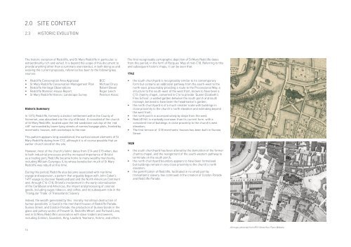
2.0 SITE CONTEXT<br />
2.3 HISTORIC EVOLUTION<br />
The historic evolution of <strong>Redcliffe</strong>, and <strong>St</strong> <strong>Mary</strong> <strong>Redcliffe</strong> in particular, is<br />
extraordinarily rich and varied. It is beyond the scope of this document to<br />
provide anything other than a summary overview but, in both doing so and<br />
evolving the current proposals, reference has been to the following key<br />
sources:<br />
• <strong>Redcliffe</strong> Conservation Area <strong>App</strong>raisal BCC<br />
• <strong>St</strong> <strong>Mary</strong> <strong>Redcliffe</strong> Conservation Management Plan Michael Drury<br />
• <strong>Redcliffe</strong> Heritage Observations Robert Bevan<br />
• <strong>Redcliffe</strong> Mansion House Report Roger Leech<br />
• <strong>St</strong> <strong>Mary</strong> <strong>Redcliffe</strong> Historic Landscape Survey Pearson Assoc<br />
Historic Summary<br />
In 1373, <strong>Redcliffe</strong>, formerly a distinct settlement within the County of<br />
Somerset, was absorbed into the city of Bristol. It consisted of the church<br />
of <strong>St</strong> <strong>Mary</strong> <strong>Redcliffe</strong>, located upon the red sandstone outcrop of the ‘red<br />
cliff’ surrounded by lower-lying streets of narrow burgage plots, fronted by<br />
merchants’ houses, with workshops to the rear.<br />
This pattern appears long-established, the earliest extant elements of <strong>St</strong><br />
<strong>Mary</strong> <strong>Redcliffe</strong> dating from C12, although it is of course possible that an<br />
earlier church stood on the site.<br />
However, most of the church’s fabric dates from C14 and C15 when, due<br />
to both industrial processes and the increased importance of Bristol<br />
as a trading port, <strong>Redcliffe</strong> became home to many wealthy merchants,<br />
including William Canynges II, by whose benefaction much of <strong>St</strong> <strong>Mary</strong><br />
<strong>Redcliffe</strong> was rebuilt at this time.<br />
During this period, <strong>Redcliffe</strong> also became associated with maritime<br />
voyage and expansion, a pattern that arguably began with John Cabot’s<br />
1497 voyage to discover Newfoundland and the North American Continent<br />
and, through C16-C18, Bristol’s involvement in the early colonialisation<br />
of the Caribbean and Americas, the import and processing of colonial<br />
goods, including sugar, tobacco, and coffee, and its subsequent role in the<br />
‘Triangular Trade’ of Transatlantic Slavery.<br />
The first recognisably cartographic depiction of <strong>St</strong> <strong>Mary</strong> <strong>Redcliffe</strong> dates<br />
from this period, in the form of Rocques’ Map of mid-C18. Referring to this<br />
and subsequent historic maps, it can be seen that:<br />
1742<br />
• the south churchyard is recognisably similar to its contemporary<br />
form but contains an additional pathway from the south-west to the<br />
north-east, presumably providing a route to the Processional Way; a<br />
structure to the south-west of the west front, known to have been a<br />
C13 chantry chapel, converted in C16 to provide ‘Queen Elizabeth’s<br />
Free School’; a walled garden between the south porch and south<br />
transept, believed to have been the headmaster’s garden;<br />
• the north churchyard is of a much smaller scale with buildings in<br />
close proximity to the church’s north elevation and extending beyond<br />
the west front;<br />
• the north porch is accessed solely by steps from the west;<br />
• Redcliff Hill is markedly narrower than its current form, with a<br />
consistent line of buildings in close proximity to the church’s west<br />
elevation;<br />
• The first terrace of C18 merchants’ houses has been built in Guinea<br />
<strong>St</strong>reet.<br />
1828<br />
• the south churchyard has been altered by the demolition of the former<br />
chantry chapel, and the realignment of the south-western pathway to<br />
terminate on the south porch;<br />
• the north churchyard boundary appears to have been formalised<br />
but buildings remain in very close proximity to the church’s north<br />
elevation;<br />
• the gentrification of <strong>Redcliffe</strong>, facilitated in no small part by<br />
transatlantic slavery, has continued in the creation of Colston Parade<br />
and <strong>Redcliffe</strong> Parade.<br />
Indeed, the wealth generated by this ‘morally monstrous destruction of<br />
human possibility’ is found in the merchant houses of <strong>Redcliffe</strong> Parade,<br />
Guinea <strong>St</strong>reet, and Colston Parade, the production of Guinea Goods in the<br />
glass and pottery works of <strong>Pre</strong>wett <strong>St</strong>, <strong>Redcliffe</strong> Wharf, and Portwall Lane,<br />
and in <strong>St</strong> <strong>Mary</strong> <strong>Redcliffe</strong>’s association with slave traders and owners,<br />
including Colston, Saunders, King, Lawford, Yeamans, Vickris, and others.<br />
16<br />
All maps extracted from BCC Know Your Place Website