


You also want an ePaper? Increase the reach of your titles
YUMPU automatically turns print PDFs into web optimized ePapers that Google loves.
REPORT<br />
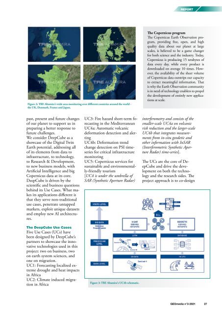
Figure 2: TRE Altamira’s wide area monitoring over different countries around the world -<br />
the UK, Denmark, France and Japan.<br />
The Copernicus program<br />
The Copernicus Earth Observation program,<br />
providing free, open, and high<br />
quality data about our planet at large<br />
scales, is believed to be a game changer<br />
for both science and the industry. Today,<br />
Copernicus is producing 15 terabytes of<br />
data every day, while every product is<br />
downloaded on average 10 times. However,<br />
the availability of the sheer volume<br />
of Copernicus data outstrips our capacity<br />
to extract meaningful information. That<br />
is why the Earth Observation community<br />
is in need of technology enablers to propel<br />
the development of entirely new applications<br />
at scale.<br />
past, present and future changes<br />
of our planet to support us in<br />
preparing a better response to<br />
future challenges.<br />
We consider DeepCube as a<br />
showcase of the Digital Twin<br />
Earth potential, addressing all<br />
of its elements from data to<br />
infrastructure, to technology,<br />
to Research & Development,<br />
to new business models, with<br />
Artificial Intelligence and big<br />
Copernicus data at its core.<br />
DeepCube is driven by the<br />
scientific and business questions<br />
behind its Use Cases. What makes<br />
its applications different is<br />
that they serve non-traditional<br />
use cases, penetrate untapped<br />
markets, exploit unique datasets<br />
and employ new AI architectures.<br />
The DeepCube Use Cases<br />
Five Use Cases (UCs) have<br />
been designed by DeepCube’s<br />
partners to showcase the innovative<br />
technologies used in this<br />
project: two on business, two<br />
on earth system sciences, and<br />
one on migration.<br />
UC1: Forecasting localized extreme<br />
drought and heat impacts<br />
in Africa<br />
UC2: Climate induced migration<br />
in Africa<br />
UC3: Fire hazard short-term forecasting<br />
in the Mediterranean<br />
UC4a: Automatic volcanic<br />
deformation detection and alerting<br />
UC4b: Deformation trend<br />
change detection on PSI timeseries<br />
for critical infrastructure<br />
monitoring<br />
UC5: Copernicus services for<br />
sustainable and environmentally-friendly<br />
tourism<br />
[UC4 is under the umbrella of<br />
SAR (Synthetic Aperture Radar)<br />
Figure 3: TRE Altamira’s UC4b schematic.<br />
interferometry and consists of the<br />
smaller-scale UC4a on volcanic<br />
risk reduction and the larger-scale<br />
UC4b that integrates measurements<br />
from in-situ geodetic and<br />
other information with InSAR<br />
(Interferometric Synthetic Aperture<br />
Radar) time-series].<br />
The UCs are the core of DeepCube<br />
and drive the development<br />
on both the technology<br />
and the research sides. The<br />
project approach is to co-design<br />
<strong>GEOmedia</strong> n°3-<strong>2021</strong> 27


