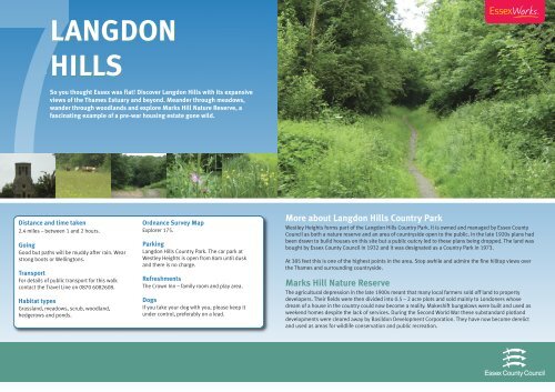
Langdon Hills Country Park - Essex County Council
Langdon Hills Country Park - Essex County Council
Langdon Hills Country Park - Essex County Council

You also want an ePaper? Increase the reach of your titles
YUMPU automatically turns print PDFs into web optimized ePapers that Google loves.
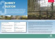
LANGDON<br />
HILLS<br />
So you thought <strong>Essex</strong> was flat! Discover <strong>Langdon</strong> <strong>Hills</strong> with its expansive<br />
views of the Thames Estuary and beyond. Meander through meadows,<br />
wander through woodlands and explore Marks Hill Nature Reserve, a<br />
fascinating example of a pre-war housing estate gone wild.<br />
Distance and time taken<br />
2.4 miles – between 1 and 2 hours.<br />
Going<br />
Good but paths will be muddy after rain. Wear<br />
strong boots or Wellingtons.<br />
Transport<br />
For details of public transport for this walk<br />
contact the Travel Line on 0870 6082608.<br />
Habitat types<br />
Grassland, meadows, scrub, woodland,<br />
hedgerows and ponds.<br />
Ordnance Survey Map<br />
Explorer 175.<br />
<strong>Park</strong>ing<br />
<strong>Langdon</strong> <strong>Hills</strong> <strong>Country</strong> <strong>Park</strong>. The car park at<br />
Westley Heights is open from 8am until dusk<br />
and there is no charge.<br />
Refreshments<br />
The Crown Inn – family room and play area.<br />
Dogs<br />
If you take your dog with you, please keep it<br />
under control, preferably on a lead.<br />
More about <strong>Langdon</strong> <strong>Hills</strong> <strong>Country</strong> <strong>Park</strong><br />
Westley Heights forms part of the <strong>Langdon</strong> <strong>Hills</strong> <strong>Country</strong> <strong>Park</strong>. It is owned and managed by <strong>Essex</strong> <strong>County</strong><br />
<strong>Council</strong> as both a nature reserve and an area of countryside open to the public. In the late 1920s plans had<br />
been drawn to build houses on this site but a public outcry led to these plans being dropped. The land was<br />
bought by <strong>Essex</strong> <strong>County</strong> <strong>Council</strong> in 1932 and it was designated as a <strong>Country</strong> <strong>Park</strong> in 1973.<br />
At 385 feet this is one of the highest points in the area. Stop awhile and admire the fine hilltop views over<br />
the Thames and surrounding countryside.<br />
Marks Hill Nature Reserve<br />
The agricultural depression in the late 1900s meant that many local farmers sold off land to property<br />
developers. Their fields were then divided into 0.5 – 2 acre plots and sold mainly to Londoners whose<br />
dream of a house in the country could now become a reality. Makeshift bungalows were built and used as<br />
weekend homes despite the lack of services. During the Second World War these substandard plotland<br />
developments were cleared away by Basildon Development Corporation. They have now become derelict<br />
and used as areas for wildlife conservation and public recreation.
Marks Hill Nature Reserve<br />
Marks Hill Nature Reserve has developed on the site of derelict plotlands. The plots<br />
are overgrown with oak and ash woodland and all that remains of Gladstone Road and<br />
Albemarle Crescent are the grassy tracks you are now walking along. The plotlands<br />
provide an important home to many plants and animals increasingly threatened by<br />
urban development.<br />
Homefield<br />
In 1968, the top soil was stripped from Homefield in anticipation<br />
of a new housing development. A Public Inquiry quashed these<br />
plans and vegetation once again re-established itself on the<br />
subsoil. Homefield is now managed as a wild flower meadow and<br />
provides a welcome splash of colour in spring and early summer.<br />
Butterflies love it!<br />
Broomhill Wood<br />
Unmanaged grassland will undergo<br />
natural succession to scrub and<br />
eventually woodland. Look out for<br />
oak, ash and hornbeam trees.<br />
Hall Wood<br />
Hall Wood is a rare example of an oak and native cherry<br />
woodland. There are views into East London from the<br />
northern boundaries of this wood and on a clear day it is<br />
possible to see the Canary Wharf tower.<br />
Hall<br />
Wood<br />
Gravelhill<br />
Wood<br />
Church<br />
High Road<br />
Westley Road<br />
Pub<br />
Stacey Drive<br />
Coombe<br />
Wood<br />
Marks<br />
Hill<br />
Nature<br />
Reserve<br />
Homestead<br />
Drive<br />
<strong>Langdon</strong><br />
<strong>Hills</strong><br />
<strong>Country</strong><br />
<strong>Park</strong><br />
Coombe Wood<br />
This is an area of ancient hunting and scenic parkland resplendent with a covering of<br />
bluebells at springtime. The path crosses the remains of a medieval ditch and bank.<br />
Staneway<br />
Westley<br />
Hall<br />
Long Wood<br />
Westley<br />
Heights<br />
Homefield<br />
Lee Chapel Lane<br />
Kingston Ridge<br />
Broomhill<br />
Wood<br />
Long Wood<br />
Long Wood has been<br />
managed as hornbeam<br />
coppice with oak standards<br />
for centuries. The resprouting<br />
hornbeam was cut frequently<br />
for firewood and then oak left<br />
for large building timbers. In<br />
spring there is an impressive<br />
display of wood anemones,<br />
primroses and bluebells.<br />
Westley Hall<br />
The absence of stone as a building material meant that houses in<br />
<strong>Essex</strong> were traditionally made from wood and brick. Westley Hall, built<br />
in the 18th century, is a good example of a timber framed and weather<br />
boarded house.<br />
Kingston Ridge Pond<br />
Kingston Ridge Pond once provided water for the plotland dwellers. It<br />
overlooks the large pond on Lee Chapel Lane, a popular spot for anglers.<br />
© <strong>Essex</strong> <strong>County</strong> <strong>Council</strong>