EUMETSAT Annual Report 2021

You also want an ePaper? Increase the reach of your titles
YUMPU automatically turns print PDFs into web optimized ePapers that Google loves.
<strong>EUMETSAT</strong> ANNUAL REPORT <strong>2021</strong><br />
CASE STUDY<br />
“<br />
Over the next five to 10 years, we will use more and<br />
more satellite products for real-time operations, as<br />
well as for the calibration and validation of hydrological<br />
forecasting models.<br />
”<br />
Dr Marius Matreata, Director of Romania’s National Hydrological Forecasts Centre<br />
Next-generation satellites such as <strong>EUMETSAT</strong>’s forthcoming<br />
Meteosat Third Generation imager series will provide tremendous<br />
opportunities to further improve flood predictions, Matreata said.<br />
For instance, data collected by MTG-I satellites will significantly<br />
boost both numerical weather prediction and nowcasting<br />
capabilities across Europe.<br />
Matreata said that the development of hydrological forecast products<br />
to take advantage of the increasing volumes of data is both a huge<br />
challenge and opportunity.<br />
“These could be crucial, especially for flooding events,” he said.<br />
“The new generations of satellite sensors and products could help<br />
us to detect initiation of intense surface runoff formation.<br />
“Over the next five to 10 years, we will use more and more satellite<br />
products for real-time operations, as well as for the calibration and<br />
validation of hydrological forecasting models.<br />
“We will be able to significantly improve our hydrological forecasting<br />
and modelling products and their spatial and temporal resolution.”<br />
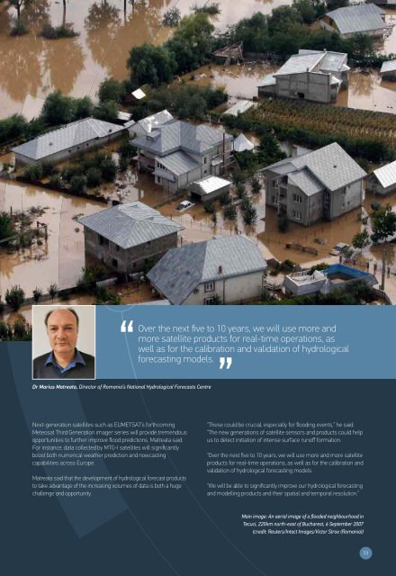
Main image: An aerial image of a flooded neighbourhood in<br />
Tecuci, 220km north-east of Bucharest, 6 September 2007<br />
(credit: Reuters/Intact Images/Victor Stroe (Romania))<br />
11