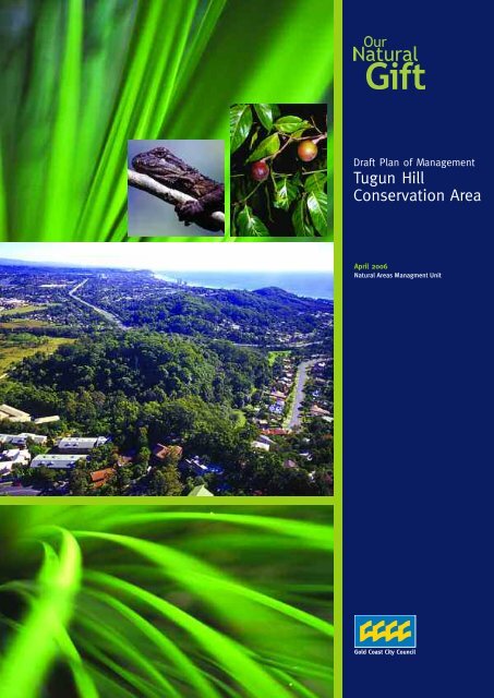
Draft Tugun Hill Conservation Area Plan of Management
Draft Tugun Hill Conservation Area Plan of Management
Draft Tugun Hill Conservation Area Plan of Management

You also want an ePaper? Increase the reach of your titles
YUMPU automatically turns print PDFs into web optimized ePapers that Google loves.
<strong>Draft</strong> <strong>Plan</strong> <strong>of</strong> <strong>Management</strong><br />
<strong>Tugun</strong> <strong>Hill</strong><br />
<strong>Conservation</strong> <strong>Area</strong><br />
April 2006<br />
Natural <strong>Area</strong>s Managment Unit
Acknowledgments:<br />
This draft plan <strong>of</strong> management was prepared by Brett Leis and Matt Newman, <strong>Conservation</strong><br />
<strong>Management</strong> <strong>Plan</strong>ners for the Natural <strong>Area</strong>s <strong>Management</strong> Unit <strong>of</strong> Gold Coast City Council. The input<br />
<strong>of</strong> Jason Searle, Liz Caddick, Graeme McGregor, Tim Robson, Phil Watts and Steve Towner is<br />
appreciated.<br />
<strong>Tugun</strong> <strong>Hill</strong> <strong>Conservation</strong> <strong>Area</strong> – <strong>Draft</strong> <strong>Plan</strong> <strong>of</strong> <strong>Management</strong>
INVITATION TO COMMENT<br />
Gold Coast City Council recognises that community consultation is vital to the functions <strong>of</strong><br />
conservation management in terms <strong>of</strong> policy development and service delivery. Inclusion <strong>of</strong><br />
the community improves the quality <strong>of</strong> management decisions through information<br />
exchange and a shared understanding <strong>of</strong> issues, and is also an effective means <strong>of</strong> fostering<br />
community stewardship.<br />
The general procedure for exhibition and adoption <strong>of</strong> a plan <strong>of</strong> management is as follows:<br />
• The draft plan is placed on public exhibition for at least 30 days and any person<br />
may comment on it;<br />
• Submissions received on the plan are referred to Gold Coast City Council;<br />
• After considering all the submissions the plan is amended, if necessary, by the<br />
Natural <strong>Area</strong>s <strong>Plan</strong>ning Unit;<br />
• The amended plan is adopted by Council.<br />
Members <strong>of</strong> the public, whether as individuals or as members <strong>of</strong> community interest<br />
groups, are invited to comment on this plan <strong>of</strong> management. Submissions should be in<br />
writing, and as detailed and specific as possible; however any comments, no matter how<br />
brief, are welcome.<br />
Comments should be forwarded to:<br />
The <strong>Plan</strong>ner, <strong>Tugun</strong> <strong>Hill</strong> <strong>Conservation</strong> <strong>Area</strong><br />
Natural <strong>Area</strong>s <strong>Plan</strong>ning Unit<br />
Parks and Recreational Services<br />
Gold Coast City Council<br />
PO Box 5042<br />
GCMC 9729 Qld<br />
The closing date for comments on the plan is Friday 23 rd June 2006.<br />
<strong>Tugun</strong> <strong>Hill</strong> <strong>Conservation</strong> <strong>Area</strong> – <strong>Draft</strong> <strong>Plan</strong> <strong>of</strong> <strong>Management</strong>
SUMMARY<br />
This plan <strong>of</strong> management provides the strategic framework that governs the development and<br />
delivery <strong>of</strong> all management programs and day-to-day issues affecting <strong>Tugun</strong> <strong>Hill</strong> <strong>Conservation</strong> <strong>Area</strong>.<br />
<strong>Tugun</strong> <strong>Hill</strong> <strong>Conservation</strong> <strong>Area</strong> is one <strong>of</strong> a series <strong>of</strong> ridges and hills that are a prominent feature <strong>of</strong><br />
the landscape <strong>of</strong> the southern Gold Coast. <strong>Tugun</strong> <strong>Hill</strong> contributes to the green back drop <strong>of</strong> the<br />
southern Gold Coast and is a major natural feature for visitors entering the city. The reserve<br />
reaches an elevation <strong>of</strong> near 50 metres above sea level and forms the upper catchment <strong>of</strong> Flat Rock<br />
Creek.<br />
<strong>Tugun</strong> <strong>Hill</strong> <strong>Conservation</strong> <strong>Area</strong> forms part <strong>of</strong> the Currumbin to Cobaki wetlands habitat corridor, an<br />
area which is considered to be <strong>of</strong> national significance for nature conservation because <strong>of</strong> its high<br />
diversity <strong>of</strong> flora and fauna. The planning area contributes to preserving the native biodiversity <strong>of</strong><br />
this area – it protects important vegetation associations and plant species and provides habitat for<br />
a range <strong>of</strong> resident and migratory fauna, and is important for local transient species utilising<br />
habitats on both sides <strong>of</strong> the border.<br />
The conservation area protects one <strong>of</strong> the last remaining populations <strong>of</strong> the Endangered Blackbutt,<br />
a vegetation type which has been reduced by land clearing and is otherwise poorly represented in<br />
protected areas. The high integrity <strong>of</strong> this community provides habitat for arboreal fauna such as<br />
koalas, possums and gliders, while the understorey has a diverse range <strong>of</strong> ground dwelling<br />
mammals including common planigale, northern brown bandicoot, yellow-footed antechinus,<br />
grassland melomys and swamp wallaby. The planning area also protects six species <strong>of</strong> plants listed<br />
under state threatened species legislation.<br />
The viability <strong>of</strong> these communities is threatened by further isolation from habitat clearing and<br />
issues associated with urban encroachment such as the introduction <strong>of</strong> weeds, predation by<br />
domestic animals, and inappropriate uses, such as the riding <strong>of</strong> trail bikes.<br />
Maintaining or enhancing the key natural values <strong>of</strong> <strong>Tugun</strong> <strong>Hill</strong> <strong>Conservation</strong> <strong>Area</strong> will be the focus<br />
<strong>of</strong> this plan <strong>of</strong> management. The planning area will be managed to conserve the natural landscape<br />
integrity and scenic, natural and cultural heritage values, while providing opportunities for lowkey,<br />
sustainable nature-based public use. A short walking circuit is proposed which will highlight<br />
the key natural features <strong>of</strong> the reserve. A weed management and restoration strategy will be<br />
implemented to enhance the ecological values <strong>of</strong> the reserve.<br />
<strong>Tugun</strong> <strong>Hill</strong> <strong>Conservation</strong> <strong>Area</strong> – <strong>Draft</strong> <strong>Plan</strong> <strong>of</strong> <strong>Management</strong>
TABLE OF CONTENTS<br />
TUGUN HILL CONSERVATION AREA PLAN OF MANAGEMENT<br />
SUMMARY<br />
Chapter 1 - Introduction ................................................................................ 7<br />
1.1 Location and <strong>Plan</strong>ning <strong>Area</strong> ..................................................................... 7<br />
1.2 Regional Context.................................................................................. 7<br />
1.3 Significance <strong>of</strong> the <strong>Conservation</strong> <strong>Area</strong> ........................................................ 8<br />
1.4 Key Threatening Processes ..................................................................... 10<br />
Chapter 2 – <strong>Management</strong> Purposes and Principles ................................................. 11<br />
2.1 Legislative and Policy Framework ............................................................ 11<br />
2.2 <strong>Management</strong> Directions......................................................................... 12<br />
2.3 Specific Objectives for <strong>Tugun</strong> <strong>Hill</strong> <strong>Conservation</strong> <strong>Area</strong> ..................................... 12<br />
Chapter 3 – <strong>Management</strong> Strategies for <strong>Tugun</strong> <strong>Hill</strong> <strong>Conservation</strong> <strong>Area</strong> ......................... 14<br />
3.1 Managing the Natural Environment ........................................................... 14<br />
3.1.1 Geology, Landform, Hydrology and Soils ............................................... 14<br />
3.1.2 Native <strong>Plan</strong>ts ................................................................................ 15<br />
3.1.3 Native Animals .............................................................................. 17<br />
3.2 Managing for Protection ........................................................................ 21<br />
3.2.1 Pest <strong>Plan</strong>ts................................................................................... 21<br />
3.2.2 Pest Animals................................................................................. 22<br />
3.2.3 Fire <strong>Management</strong> ........................................................................... 24<br />
3.2.4 Habitat Fragmentation and Isolation .................................................... 27<br />
3.3 Managing Cultural Heritage .................................................................... 29<br />
3.4 Managing Recreation ............................................................................ 31<br />
3.5 Community Involvement, Interpretation and Education .................................. 33<br />
3.5 Managing Access ................................................................................. 35<br />
3.6 Managing Landscape and Scenic Amenity.................................................... 36<br />
3.7 Research and Monitoring ....................................................................... 37<br />
3.9 Naming <strong>of</strong> the <strong>Conservation</strong> <strong>Area</strong> ............................................................. 39<br />
Chapter 4 - <strong>Plan</strong> Implementation..................................................................... 40<br />
Chapter 5 – Summary <strong>of</strong> <strong>Management</strong> Strategies .................................................. 41<br />
Chapter 7 – References................................................................................. 51<br />
Chapter 8 – <strong>Conservation</strong> <strong>Area</strong> Maps ................................................................. 52<br />
Chapter 9 - Appendices ................................................................................ 52<br />
<strong>Tugun</strong> <strong>Hill</strong> <strong>Conservation</strong> <strong>Area</strong> – <strong>Draft</strong> <strong>Plan</strong> <strong>of</strong> <strong>Management</strong>
Abbreviations used in this <strong>Management</strong> <strong>Plan</strong><br />
CAMBA: China and Australia Migratory Bird Agreement<br />
EPBC: Commonwealth Environment Protection and Biodiversity <strong>Conservation</strong> Act 1999.<br />
GCCC: Gold Coast City Council<br />
JAMBA: Japan and Australia Migratory Bird Agreement<br />
NCA: QLD Nature <strong>Conservation</strong> Act 1992<br />
OSPL: Open Space Preservation Levy<br />
QPWS: Queensland Parks and Wildlife Service<br />
TSC: NSW Threatened Species <strong>Conservation</strong> Act 1995.<br />
<strong>Tugun</strong> <strong>Hill</strong> <strong>Conservation</strong> <strong>Area</strong> – <strong>Draft</strong> <strong>Plan</strong> <strong>of</strong> <strong>Management</strong>
Chapter 1 - Introduction<br />
1.1 Location and <strong>Plan</strong>ning <strong>Area</strong><br />
<strong>Tugun</strong> <strong>Hill</strong> <strong>Conservation</strong> <strong>Area</strong> (referred to as “<strong>Tugun</strong> <strong>Hill</strong>” in this plan) is located in the<br />
southern Gold Coast adjacent to the M1 Motorway and the proposed route <strong>of</strong> the <strong>Tugun</strong><br />
Bypass. The planning area covers 14.5 hectares <strong>of</strong> land acquired with the Open Space<br />
Preservation Levy and a further 1.4 hectares <strong>of</strong> adjoining reserved land to the south, which<br />
Council holds as trustee on behalf <strong>of</strong> the Government <strong>of</strong> Queensland. This plan also makes<br />
recommendations on the management <strong>of</strong> the series <strong>of</strong> adjoining reserved land which form<br />
the Currumbin Point to Cobaki Wetlands habitat corridor and contribute to the overall<br />
ecological value <strong>of</strong> the region.<br />
The conservation area is one <strong>of</strong> a series <strong>of</strong> ridges and hills that are a prominent feature <strong>of</strong><br />
the landscape <strong>of</strong> the southern Gold Coast. <strong>Tugun</strong> <strong>Hill</strong> contributes to the green backdrop <strong>of</strong><br />
the area, and retains valuable wildlife habitat in an otherwise highly urbanised landscape.<br />
The hill reaches an elevation <strong>of</strong> near 50 metres above sea level and forms the upper<br />
catchment <strong>of</strong> Flat Rock Creek.<br />
The site is characterised by a central hill with two prominent gully lines. The land<br />
predominantly supports a mix <strong>of</strong> remnant and regrowth Blackbutt (Eucalyptus pilularis)<br />
open forest with other areas supporting a matrix <strong>of</strong> regenerating vegetation types<br />
including gully vine forest and regrowth woodland dominated by Blackwood (Acacia<br />
melanoxylon) and Soapbush (Alphitonia excelsa).<br />
1.2 Regional Context<br />
The <strong>Conservation</strong> <strong>Area</strong> is one <strong>of</strong> a number <strong>of</strong> mostly small forested reserves in this region.<br />
Others include the Currumbin <strong>Hill</strong> <strong>Conservation</strong> Park, sections <strong>of</strong> the Currumbin Wildlife<br />
Sanctuary, the mangrove-lined reserves along Currumbin Creek and the Cobaki Wetlands<br />
reserves in New South Wales. The planning area also links to a narrow wildlife corridor<br />
extending west to Nicolls Scrub National Park in the Currumbin Valley. Each reserve is<br />
isolated to some degree from other remnant vegetation by features such as roads, urban<br />
development or cleared land.<br />
The M1 Motorway, which has a barrier fence along its length, physically separates <strong>Tugun</strong><br />
<strong>Hill</strong> from the Currumbin reserves. To the south <strong>of</strong> <strong>Tugun</strong> <strong>Hill</strong>, vegetation on the<br />
Department <strong>of</strong> Main Roads Reserve provides a vegetated link to the larger habitat systems<br />
<strong>of</strong> the Cobaki area in New South Wales via remnant vegetation on other freehold lands.<br />
The development <strong>of</strong> the <strong>Tugun</strong> Bypass would threaten this linkage by removing most<br />
remnant vegetation on the road reserve. <strong>Tugun</strong> <strong>Hill</strong> is directly bordered by residential and<br />
multi occupancy development to the east and south.<br />
<strong>Tugun</strong> <strong>Hill</strong> <strong>Conservation</strong> <strong>Area</strong> – <strong>Draft</strong> <strong>Plan</strong> <strong>of</strong> <strong>Management</strong>
Figure1: Location <strong>of</strong> <strong>Tugun</strong> <strong>Hill</strong> <strong>Conservation</strong> <strong>Area</strong><br />
<strong>Management</strong><br />
Boundary<br />
Contours<br />
30<br />
20<br />
<strong>Tugun</strong><br />
Proposed<br />
Proposed Proposed<br />
Pacific Pacific Pacific Motorway Motorway Motorway Motorway Motorway Motorway Motorway Motorway Motorway (M1)<br />
(M1)<br />
(M1)<br />
<strong>Tugun</strong> <strong>Tugun</strong> <strong>Tugun</strong> <strong>Tugun</strong> <strong>Tugun</strong> <strong>Tugun</strong> <strong>Tugun</strong> <strong>Tugun</strong><br />
Bypass Bypass Bypass Bypass Bypass Bypass Bypass Bypass Bypass<br />
MURRAY MURRAY MURRAY MURRAY MURRAY MURRAY MURRAY MURRAY MURRAY<br />
STREET STREET STREET STREET STREET STREET STREET STREET STREET<br />
<strong>Tugun</strong> <strong>Hill</strong> <strong>Conservation</strong> <strong>Area</strong><br />
CLANCY CLANCY CLANCY CLANCY CLANCY CLANCY CLANCY CLANCY CLANCY CRT CRT CRT CRT CRT CRT CRT CRT CRT<br />
250m NORTH �<br />
<strong>Tugun</strong> <strong>Hill</strong> <strong>Conservation</strong> <strong>Area</strong> – <strong>Draft</strong> <strong>Plan</strong> <strong>of</strong> <strong>Management</strong><br />
55<br />
40<br />
30<br />
ALINJARRA ALINJARRA ALINJARRA ALINJARRA ALINJARRA ALINJARRA ALINJARRA ALINJARRA ALINJARRA DR DR DR DR DR DR DR<br />
Property Boundary<br />
Street/ Road<br />
20<br />
MURRAY MURRAY MURRAY MURRAY MURRAY MURRAY MURRAY MURRAY MURRAY<br />
STREET STREET STREET STREET STREET STREET STREET STREET STREET<br />
TAPERELL TAPERELL TAPERELL TAPERELL TAPERELL TAPERELL TAPERELL TAPERELL TAPERELL DR DR DR<br />
DR DR<br />
DR DR<br />
MIRREEN<br />
MIRREEN<br />
ORMEAU<br />
ORMEAU<br />
SPRINGBROOK<br />
SPRINGBROOK<br />
COOMERA<br />
COOMERA<br />
COOMERA<br />
SURFERS SURFERS SURFERS SURFERS PARADISE PARADISE<br />
PARADISE<br />
MUDGEERABA<br />
MUDGEERABA
1.3 Significance <strong>of</strong> the <strong>Conservation</strong> <strong>Area</strong><br />
The <strong>Tugun</strong> to Cobaki area is considered to be <strong>of</strong> national significance for nature<br />
conservation. It supports a high diversity <strong>of</strong> terrestrial flora and fauna <strong>of</strong> conservation<br />
significance. <strong>Tugun</strong> <strong>Hill</strong> <strong>Conservation</strong> <strong>Area</strong> contributes to preserving the native biodiversity<br />
<strong>of</strong> this area – it conserves important vegetation associations and plant species and provides<br />
habitat for a range <strong>of</strong> resident and migratory fauna, and is an important linkage in the<br />
Currumbin Point to Cobaki lakes reserves.<br />
The planning area also <strong>of</strong>fers a natural setting, in an otherwise highly urbanised<br />
environment, for locals to undertake passive nature based recreation pursuits. <strong>Tugun</strong> <strong>Hill</strong><br />
contributes to the green back drop <strong>of</strong> the southern Gold Coast and is a major natural<br />
feature for visitors entering the city.<br />
Some <strong>of</strong> the significant natural values <strong>of</strong> <strong>Tugun</strong> <strong>Hill</strong> <strong>Conservation</strong> <strong>Area</strong> include:<br />
� The hilltop is dominated by ‘Eucalyptus pilularis (blackbutt) tall woodland to open<br />
forest on metasediments’, a vegetation community classified as Endangered under the<br />
Queensland Vegetation <strong>Management</strong> Act 1999. This is one <strong>of</strong> the last remaining patches<br />
<strong>of</strong> this vegetation type on the Gold Coast.<br />
� Protects at least six species <strong>of</strong> threatened plants that are listed under the Queensland<br />
Nature <strong>Conservation</strong> Act 1992. This includes the Vulnerable velvet laurel (Endiandra<br />
hayseii), and Rare black walnut (Endiandra globosa), long-leafed tuckeroo (Cupaniopsis<br />
newmanii), rosy hyacinth orchid (Dipodium pulchellum), smooth scrub turpentine<br />
(Rhodamnia maideniana) and white lace flower (Arcidendron hendersonii).<br />
� Provides both regionally and locally significant fauna habitats and an important link<br />
between the habitats <strong>of</strong> the Currumbin Sanctuary/Currumbin <strong>Conservation</strong> Park and<br />
the Cobaki Wetlands in Tweed Shire to the south, and to the large tracts <strong>of</strong> bushland in<br />
the Currumbin Valley to the west. These links are important for the more mobile<br />
avifauna that travel between inland and coastal habitats.<br />
� Supports fauna species that are listed under NSW, QLD and/or commonwealth<br />
threatened species legislation including the Vulnerable koala, common planigale, greyheaded<br />
flying fox, little bent–wing bat and rose-crowned fruit dove, and Rare Lewin’s<br />
rail. It also protects species which are significant at a regional and local level including<br />
the northern brown bandicoot, yellow-footed antechinus, grassland melomys and<br />
swamp wallaby.<br />
� Supports good populations <strong>of</strong> forest dependant, nomadic and migratory birds, being<br />
further significant due to the ongoing diminishment <strong>of</strong> similar habitats across the<br />
lowland areas <strong>of</strong> the Gold Coast and northern New South Wales. A number <strong>of</strong> birds are<br />
listed under various international agreements, including JAMBA and CAMBA.<br />
<strong>Tugun</strong> <strong>Hill</strong> <strong>Conservation</strong> <strong>Area</strong> – <strong>Draft</strong> <strong>Plan</strong> <strong>of</strong> <strong>Management</strong>
1.4 Key Threatening Processes<br />
In light <strong>of</strong> the landscape context, history <strong>of</strong> the site and surrounds and the current<br />
ecological condition <strong>of</strong> the conservation area, a number <strong>of</strong> key threatening processes can<br />
be identified. These include:<br />
1. The further isolation <strong>of</strong> the reserve from other habitat by clearing <strong>of</strong> vegetation,<br />
the construction <strong>of</strong> roads, fences and residential development.<br />
2. The fire regime; the character <strong>of</strong> some fire adapted or tolerant vegetation types<br />
can be lost altogether if fire is excluded for an extended period (Watson, P., 2001,<br />
SEQ FABC). Conversely, while fire is a catalyst for regeneration for some flora<br />
species at <strong>Tugun</strong> <strong>Hill</strong>, fires occurring at too frequent intervals can prevent plants<br />
reaching a stage <strong>of</strong> maturity at which they can reproduce, leading to their eventual<br />
loss from the vegetation community. Frequent fires may also wipe out populations<br />
<strong>of</strong> fauna and change habitat conditions, making them unsuitable for fauna.<br />
3. The impacts <strong>of</strong> pest animals on native fauna and the impacts <strong>of</strong> pest plants on flora<br />
and on fauna habitat.<br />
4. The destruction <strong>of</strong> flora, vegetation community structure and soil pr<strong>of</strong>iles by human<br />
activities.<br />
5. The disruption or changes to plant communities and fauna habitat caused by human<br />
induced edge effects.<br />
The most pressing issue in managing <strong>Tugun</strong> <strong>Hill</strong> over the short, medium and long terms<br />
will be the potential loss <strong>of</strong> flora and fauna species as a result <strong>of</strong> the effects <strong>of</strong> the<br />
above threatening processes. It needs to be recognised that while management <strong>of</strong> the<br />
site may result in improvements in habitat, the small size and ongoing isolation <strong>of</strong> the<br />
reserve from other remnants may still lead to the unpreventable local extinction <strong>of</strong><br />
species currently present at <strong>Tugun</strong> <strong>Hill</strong> <strong>Conservation</strong> <strong>Area</strong>.<br />
<strong>Tugun</strong> <strong>Hill</strong> <strong>Conservation</strong> <strong>Area</strong> – <strong>Draft</strong> <strong>Plan</strong> <strong>of</strong> <strong>Management</strong>
Chapter 2 – <strong>Management</strong> Purposes and<br />
Principles<br />
2.1 Legislative and Policy Framework<br />
The OSPL Acquisition Program contributes to achieving the core objectives <strong>of</strong> the Gold<br />
Coast City Nature <strong>Conservation</strong> Strategy (GCCC, 1998) by securing the protection <strong>of</strong> areas<br />
<strong>of</strong> high conservation value in public ownership where other strategies are unable to<br />
achieve the required level <strong>of</strong> protection. One <strong>of</strong> the major aims <strong>of</strong> the Acquisition<br />
Program is to consolidate and expand the City’s existing protected area network and assist<br />
Council in fulfilling the intent <strong>of</strong> the ‘<strong>Conservation</strong> Strategy <strong>Plan</strong>’ contained within the<br />
Nature <strong>Conservation</strong> Strategy (NCS).<br />
<strong>Tugun</strong> <strong>Hill</strong> was purchased under the OSPL Acquisition Program on the 23 rd June 2000 for the<br />
principle purpose <strong>of</strong> nature conservation. The direction for management <strong>of</strong> <strong>Tugun</strong> <strong>Hill</strong><br />
<strong>Conservation</strong> <strong>Area</strong> reflects the over-arching principle established in the document<br />
“<strong>Management</strong> Guidelines for sites acquired with the Open Space Preservation Levy (Phase<br />
1 & 2 Acquisition Programs)”. The principle states:<br />
Sites acquired with funds derived from the Open Space Preservation Levy, (as<br />
part <strong>of</strong> the Open Space Preservation Levy Acquisition Program – Phases 1 and<br />
2), have been acquired primarily for nature conservation and must be managed<br />
to preserve the ecological values that Council bought each site to protect and<br />
used in such a way so not to have a negative impact upon those values.<br />
The Guidelines, adopted by Council in December 2004, describe the actions required for<br />
the short-term management <strong>of</strong> the sites and recommendations for longer-term<br />
management. Many <strong>of</strong> the actions or strategies initiated as an ‘Immediate Action’ via the<br />
Guidelines are recommended to continue as actions contained in a plan <strong>of</strong> management.<br />
Other legislation, international agreements and charters may also apply to management <strong>of</strong><br />
the area. In particular, all actions recommended in and implemented through this<br />
management plan will take into consideration any likely impacts upon species or ecological<br />
communities <strong>of</strong> significance listed under the Environment Protection and Biodiversity<br />
<strong>Conservation</strong> Act 1999, the Queensland Nature <strong>Conservation</strong> Act 1992 and the Nature<br />
<strong>Conservation</strong> (Wildlife) Regulation 1994.<br />
Council also has obligations to protect the habitats <strong>of</strong> migratory birds under agreements<br />
such as the Japan-Australia and China-Australia Migratory Bird Agreements (JAMBA and<br />
CAMBA).<br />
The eradication, control or containment <strong>of</strong> declared weeds and introduced animals on<br />
Council land is governed by the Land Protection (Pest and Stock Route <strong>Management</strong>) Act<br />
2002. Control <strong>of</strong> pest animals is also in accordance with the Queensland’s Pest Animal<br />
Strategy 2002-2006.<br />
Protection <strong>of</strong> Aboriginal culture heritage values is in accordance with the QLD Cultural<br />
Heritage Act 2003.<br />
The Queensland Fire and Rescue Services Act 1990 requires Council, as a landowner, to<br />
remove or reduce the risk <strong>of</strong> fire occurring on their land and to take all necessary steps to<br />
ensure that fire does not impact on neighbouring properties.<br />
The most pressing fire management issues at <strong>Tugun</strong> <strong>Hill</strong> have been dealt with as an<br />
immediate action. Strategies and actions for managing the effects <strong>of</strong> fire on the<br />
environment are included within this management plan.<br />
<strong>Tugun</strong> <strong>Hill</strong> <strong>Conservation</strong> <strong>Area</strong> – <strong>Draft</strong> <strong>Plan</strong> <strong>of</strong> <strong>Management</strong>
2.2 <strong>Management</strong> Directions<br />
A plan <strong>of</strong> management provides the framework for management <strong>of</strong> the area by stating the<br />
philosophy on which decisions should be based and by setting out objectives and actions<br />
for management. Each plan <strong>of</strong> management will establish a limited range <strong>of</strong> uses <strong>of</strong> the<br />
site that are agreed by Council and supported by the community as being consistent with<br />
maintaining the site’s ecological, other environmental and visual values.<br />
<strong>Management</strong> decisions for the conservation areas purchased under the OSPL are based on<br />
four core principles:<br />
1. <strong>Conservation</strong> areas acquired through the OSPL Acquisition Program will be primarily<br />
managed to preserve the full range <strong>of</strong> significant natural values that they possess.<br />
This is the over-riding principle that will be applied when considering all land use<br />
proposals and options for management.<br />
2. Protection <strong>of</strong> natural values provides the basis for ecologically sustainable managed<br />
use <strong>of</strong> the <strong>Conservation</strong> <strong>Area</strong>s by the community.<br />
3. Protection <strong>of</strong> the natural values <strong>of</strong> the conservation areas can also provide benefits<br />
to the community by preserving ecosystem services, scenic amenity and enhancing<br />
catchment and cultural heritage values.<br />
4. The long-term protection <strong>of</strong> the natural values <strong>of</strong> the conservation areas will be<br />
achieved more readily if the community understands and supports Council’s goals<br />
for management.<br />
2.3 Specific Objectives for <strong>Tugun</strong> <strong>Hill</strong> <strong>Conservation</strong><br />
<strong>Area</strong><br />
The planning area will be managed to conserve the natural landscape integrity and scenic,<br />
natural and cultural heritage values, while providing opportunities for low-key, sustainable<br />
nature-based public use. Strategies and programs to protect, and where necessary restore,<br />
the natural and cultural values <strong>of</strong> the planning area will aim to:<br />
• Manage the Currumbin to Cobaki wetlands reserves as an interrelated reserve system;<br />
• Enhance the natural environment and control introduced plant species with<br />
consideration <strong>of</strong> habitat utilisation by native animal species;<br />
• Control, and where possible eradicate, introduced animal species particularly<br />
predatory species which threaten ground-dwelling native fauna;<br />
• Restore and maintain viable habitat links contributing to the ecological richness <strong>of</strong> the<br />
area;<br />
• Protect and monitor threatened and biogeographically significant species and<br />
communities;<br />
• Protect and enhance the landscape and scenic values <strong>of</strong> <strong>Tugun</strong> <strong>Hill</strong>;<br />
• Protect cultural heritage values;<br />
• Protect water catchment values <strong>of</strong> Flat Rock Creek;<br />
• Encourage and facilitate research and monitoring to improve knowledge <strong>of</strong> natural and<br />
cultural values <strong>of</strong> the area;<br />
• Implement fire management actions for the protection <strong>of</strong> life and property;<br />
• Implement fire regimes designed to maintain the diversity <strong>of</strong> vegetation communities;<br />
• Engender greater public awareness and appreciation for the values and management <strong>of</strong><br />
the planning area;<br />
• Manage visitor use in an ecologically sustainable manner; and<br />
<strong>Tugun</strong> <strong>Hill</strong> <strong>Conservation</strong> <strong>Area</strong> – <strong>Draft</strong> <strong>Plan</strong> <strong>of</strong> <strong>Management</strong>
• Maintain a good working relationship with neighbours, authorities, Government<br />
departments and other agencies to enhance the protection and viability <strong>of</strong> the planning<br />
area.<br />
<strong>Tugun</strong> <strong>Hill</strong> <strong>Conservation</strong> <strong>Area</strong> – <strong>Draft</strong> <strong>Plan</strong> <strong>of</strong> <strong>Management</strong>
Chapter 3 – <strong>Management</strong> Strategies for<br />
<strong>Tugun</strong> <strong>Hill</strong> <strong>Conservation</strong> <strong>Area</strong><br />
3.1 Managing the Natural Environment<br />
3.1.1 Geology, Landform, Hydrology and Soils<br />
<strong>Tugun</strong> <strong>Hill</strong> <strong>Conservation</strong> <strong>Area</strong> is situated on the first <strong>of</strong> a series <strong>of</strong> low coastal hills which<br />
rise from the sandy coastal plain <strong>of</strong> Currumbin Point. The topography <strong>of</strong> the site is<br />
characterised by a prominent hill and associated hill-slopes and gully lines.<br />
Overall the landform can be described as gentle to moderately steep low hill-slopes <strong>of</strong><br />
meta-sedimentary geology, supporting tall moist eucalypt open forest. The majority <strong>of</strong> the<br />
planning area is less than fifty metres above sea level and protects the headwaters <strong>of</strong> Flat<br />
Rock Creek.<br />
The underlying geology <strong>of</strong> this area is classified as the Neranleigh-Fernvale metasediments,<br />
which are deformed, lightly to heavily folded rocks derived from ancient<br />
marine sediments. This is the predominant geological unit throughout the central area <strong>of</strong><br />
Gold Coast City and also encompasses extensive areas to the north-west <strong>of</strong> the<br />
conservation area.<br />
The composition <strong>of</strong> the underlying rock varies with location, and may incorporate arenite,<br />
mudstone, shale, chert, jasper or basic metavolcanics. The soils are similarly variable, and<br />
may comprise yellow, red, brown or grey kurosols or red ferrosols.<br />
The vegetated slopes <strong>of</strong> the conservation area protect the hillsides from erosion and<br />
provide catchment protection for the upper parts <strong>of</strong> Flat Rock Creek.<br />
Desired Outcomes<br />
• Geological and soil landscapes are protected from human disturbance.<br />
• Catchment values, water quality and the health <strong>of</strong> waterways are maintained or<br />
improved.<br />
<strong>Management</strong> Strategies<br />
S1.1 Ensure conservation area facilities, visitor use and management actions do not<br />
adversely impact on water quality or soil landscapes.<br />
S1.2 Locate new infrastructure and facilities outlined in this plan on previously disturbed<br />
sites wherever possible.<br />
S1.3 Develop a staged restoration plan for Flat Rock Creek drainage line between the<br />
conservation area’s north-eastern boundary and the Motorway; the species composition<br />
should reflect the predicted original vegetation type – Regional Ecosystem 12.3.11 (GCCC<br />
Vegetation Type 6).<br />
S1.4 Avoid further interference to the natural drainage patterns to restrict erosion <strong>of</strong> soils<br />
within and adjacent to the reserve.<br />
<strong>Tugun</strong> <strong>Hill</strong> <strong>Conservation</strong> <strong>Area</strong> – <strong>Draft</strong> <strong>Plan</strong> <strong>of</strong> <strong>Management</strong>
3.1.2 Native <strong>Plan</strong>ts<br />
<strong>Tugun</strong> <strong>Hill</strong> retains a diverse and significant collection <strong>of</strong> flora species and vegetation<br />
communities. A total <strong>of</strong> 159 species <strong>of</strong> vascular plants from 127 genera and 61 families<br />
have been recorded within <strong>Tugun</strong> <strong>Hill</strong>. Six <strong>of</strong> these species are listed as threatened under<br />
Queensland’s Nature <strong>Conservation</strong> Act 1992.<br />
Approximately one-third <strong>of</strong> <strong>Tugun</strong> <strong>Hill</strong> supports mature Moist Open Forest with a canopy<br />
dominated by Blackbutt (Eucalyptus pilularis). This community is generally <strong>of</strong> high<br />
ecological condition and representative <strong>of</strong> the late successional growth (or ‘old growth’)<br />
phase <strong>of</strong> this forest type, providing core habitat for arboreal fauna. Despite being<br />
previously widespread along the coastal lowlands <strong>of</strong> the Gold Coast mainland, this<br />
vegetation type is now relatively scarce as a result <strong>of</strong> extensive urban development, and is<br />
also poorly represented in protected areas throughout the region. This is reflected by its<br />
classification as Endangered under the provisions <strong>of</strong> the QLD Vegetation <strong>Management</strong> Act<br />
1999 (Regulation 2000). One species <strong>of</strong> plant listed under the Nature <strong>Conservation</strong> Act<br />
1992 has also been identified in this area:<br />
� Rosy Hyacinth-orchid (Dipodium pulchella) (Rare)<br />
A small pocket <strong>of</strong> sub-tropical rainforest occurs in a moist drainage area on the southwestern<br />
facing slope. This community is generally <strong>of</strong> high ecological condition, supporting<br />
a relatively diverse array <strong>of</strong> native rainforest flora in a small area. Five species listed<br />
under the Nature <strong>Conservation</strong> Act 1992 have been identified in this community. These<br />
are:<br />
� Velvet laurel (Endiandra hayseii) (Vulnerable)<br />
� Long-leafed tuckeroo (Cupaniopsis newmanii) (Rare)<br />
� Smooth scrub turpentine (Rhodamnia maideniana) (Rare)<br />
� Black walnut (Endiandra globosa) (Rare)<br />
� White lace flower (Arcidendron hendersonii) (Rare)<br />
The small size and conservation significance <strong>of</strong> the subtropical rainforest makes it<br />
vulnerable to impacts. For this reason, visitor activities will be restricted from this area.<br />
Closed forest occurs along gully lines, which is characteristically wetter than the<br />
surrounding Blackbutt Moist Open Forest and supports a wider variety <strong>of</strong> rainforest plant<br />
species. Tallowwood (Eucalyptus microcorys) and Forest Red Gum (Eucalyptus tereticornis)<br />
woodland communities, which vary slightly in composition to the adjoining Blackbutt Moist<br />
Open Forest, are also present on the north-western hill-slopes. In addition, several small<br />
grassland patches occur in previously cleared areas.<br />
Around one-third <strong>of</strong> the property supports areas <strong>of</strong> regrowth Blackbutt Open Forest and<br />
Acacia Woodland, which appears to represent early successional regrowth on land<br />
previously cleared.<br />
The major potential threats to the native vegetation communities within <strong>Tugun</strong> <strong>Hill</strong><br />
include uncontrolled access (both vehicle and pedestrian trampling), inappropriate fire<br />
regimes and woody weed infestation.<br />
Council has undertaken preliminary restoration within <strong>Tugun</strong> <strong>Hill</strong>, including revegetation<br />
activities and ongoing weed control. Strategic direction for these activities will be guided<br />
by the <strong>Tugun</strong> <strong>Hill</strong> <strong>Conservation</strong> <strong>Area</strong> Restoration <strong>Plan</strong>. This plan provides the practical<br />
guidelines for long-term native vegetation restoration by aiming to allow favourable<br />
conditions for the natural regeneration <strong>of</strong> native plant species. The potential <strong>of</strong> natural<br />
regeneration is considered to be relatively high once appropriate, effective and ongoing<br />
<strong>Tugun</strong> <strong>Hill</strong> <strong>Conservation</strong> <strong>Area</strong> – <strong>Draft</strong> <strong>Plan</strong> <strong>of</strong> <strong>Management</strong>
weed control measures are implemented. Indeed, there is ample evidence <strong>of</strong> native<br />
regeneration occurring throughout the conservation area and by effective promotion <strong>of</strong><br />
this process, further planting for regeneration purposes would not be necessary.<br />
Buffer planting will be undertaken along the western edge <strong>of</strong> the reserve to limit any<br />
impacts associated with adjacent construction <strong>of</strong> the <strong>Tugun</strong> Bypass.<br />
Desired Outcomes<br />
• The full range <strong>of</strong> native plant species found in the conservation area are protected.<br />
• Vegetation structural diversity and habitat values are conserved, and are restored<br />
where subject to past disturbance.<br />
• Significant and protected plant species and communities are protected.<br />
• Knowledge <strong>of</strong> significant flora and vegetation communities is increased.<br />
• Habitat connectivity is maintained and/or enhanced.<br />
<strong>Management</strong> Strategies<br />
S2.1 Implement the <strong>Tugun</strong> <strong>Hill</strong> <strong>Conservation</strong> <strong>Area</strong> Restoration <strong>Plan</strong> as a matter <strong>of</strong> priority.<br />
S2.2 Manage the sub-tropical rainforest community for protection purposes by restricting<br />
visitor access to this area, avoiding burning and removing weeds.<br />
S2.3 Manage the blackbutt moist open forest for protection purposes by allowing only<br />
walking access to this area along designated, existing trails (see Section 3.4 Managing<br />
Recreation).<br />
S2.4 Prioritise the restoration <strong>of</strong> the Blackbutt moist open forest by promoting favourable<br />
recruitment conditions and utilising the zoning approach as outlined in the <strong>Tugun</strong> <strong>Hill</strong><br />
<strong>Conservation</strong> <strong>Area</strong> Restoration <strong>Plan</strong>.<br />
S2.5 Develop a systematic monitoring program to assess the regeneration <strong>of</strong> native plant<br />
species within key vegetation types in association with the <strong>Tugun</strong> <strong>Hill</strong> <strong>Conservation</strong> <strong>Area</strong><br />
Restoration <strong>Plan</strong>. Monitoring results will be used to refine, as necessary, restoration<br />
practices.<br />
S2.6 Establish monitoring regimes for key plant species regarded as threatened or<br />
significant to measure the success <strong>of</strong> management practices in maintaining or improving<br />
the conservation status <strong>of</strong> these species and to record ongoing change.<br />
S2.7 Develop and implement a buffer planting plan for the western edge <strong>of</strong> the<br />
<strong>Conservation</strong> <strong>Area</strong> in partnership with the Department <strong>of</strong> Main Roads.<br />
S2.8 Implement infill revegetation along the edge <strong>of</strong> the rock lined drainage channel:<br />
consider planting within the channel where appropriate to enhance sediment control,<br />
habitat establishment and improve the aesthetic quality <strong>of</strong> the area.<br />
S2.9 Only use those species recorded within <strong>Tugun</strong> <strong>Hill</strong> <strong>Conservation</strong> <strong>Area</strong> for revegetation<br />
projects.<br />
S2.10 Manage threatened species populations in accordance with the declared<br />
management intent <strong>of</strong> the listing under the Nature <strong>Conservation</strong> (Wildlife) Regulation<br />
1994.<br />
<strong>Tugun</strong> <strong>Hill</strong> <strong>Conservation</strong> <strong>Area</strong> – <strong>Draft</strong> <strong>Plan</strong> <strong>of</strong> <strong>Management</strong>
S2.11 Develop a program <strong>of</strong> seed collection from other local provenance populations <strong>of</strong><br />
threatened plant species to propagate and plant at <strong>Tugun</strong> <strong>Hill</strong> to increase the size and<br />
genetic diversity <strong>of</strong> the local populations.<br />
S2.12 Consider the translocation <strong>of</strong> threatened and significant plant species which are<br />
likely to be removed during the <strong>Tugun</strong> Bypass construction in conjunction with the<br />
Department <strong>of</strong> Main Roads.<br />
S2.13 Ensure that management operations, such as slashing, fire, weed control and road<br />
and walking trail maintenance, do not impact upon significant plant species and<br />
communities.<br />
S2.14 Develop walking trails as outlined in this plan <strong>of</strong> management with the aim <strong>of</strong><br />
reducing impacts on native plant communities by utilising existing trails.<br />
S2.15 Undertake fire management in a manner that enhances and protects species<br />
diversity in vegetation communities and encourages recruitment <strong>of</strong> significant species as<br />
identified in Section 5.2.3 Fire <strong>Management</strong>.<br />
S2.16 Encourage surveys and research on significant plant and vegetation communities to<br />
improve knowledge <strong>of</strong> their management requirements and recruitment capabilities.<br />
S2.17 Promote public understanding and appreciation <strong>of</strong> the native plants and vegetation<br />
communities <strong>of</strong> the conservation area within the context <strong>of</strong> the Interpretation <strong>Plan</strong><br />
(Section 5.8 Community Involvement, Interpretation and Education)). The plan will include<br />
strategies for interpreting:<br />
• The values and significance <strong>of</strong> the blackbutt vegetation and rare and significant<br />
plant species;<br />
• The strategies adopted by GCCC to reduce threatening processes on the native<br />
vegetation <strong>of</strong> the conservation area;<br />
• The role <strong>of</strong> visitors in protecting native plants through the adoption <strong>of</strong> minimal<br />
impact recreation protocols.<br />
S2.18 Promote the planting <strong>of</strong> local native garden species by neighbours directly bordering<br />
the conservation area.<br />
3.1.3 Native Animals<br />
Despite its small overall size, <strong>Tugun</strong> <strong>Hill</strong> contains a relatively diverse assemblage <strong>of</strong> native<br />
fauna, including a number <strong>of</strong> threatened, migratory and locally significant species, as well<br />
as species with quite specific habitat requirements. At least 14 mammals, 70 birds, 6<br />
reptile and 4 amphibian species are known to occur within the planning area. Survey work<br />
has been limited in <strong>Tugun</strong> <strong>Hill</strong> and it is likely that additional species would be recorded<br />
with further survey effort.<br />
Although relatively small in total area, the bushland mosaic present within the<br />
conservation area provides a viable and valuable habitat for a wide variety <strong>of</strong> native fauna<br />
species and key linkages to larger habitat systems. The site is an important ‘habitat island’<br />
for mobile fauna, particularly locally transient bird and bat species, forming a vital link in<br />
a wildlife corridor for these animals extending from the coastal Currumbin Bird Sanctuary/<br />
Currumbin <strong>Hill</strong> <strong>Conservation</strong> Parks in the north to the Cobaki Wetlands in the Tweed shire<br />
to the south.<br />
Native ground dwelling and arboreal mammals are well represented. The mature blackbutt<br />
moist open forest provides habitat for a range <strong>of</strong> arboreal fauna, including the koala, sugar<br />
glider and common brushtail possum. The understorey layers protect a range <strong>of</strong> grounddwelling<br />
species including the grassland melomys, common planigale, swamp wallaby,<br />
yellow-footed antechinus and northern brown bandicoot.<br />
<strong>Tugun</strong> <strong>Hill</strong> <strong>Conservation</strong> <strong>Area</strong> – <strong>Draft</strong> <strong>Plan</strong> <strong>of</strong> <strong>Management</strong>
Migratory, nomadic and resident bird species are well represented at <strong>Tugun</strong> <strong>Hill</strong>. The<br />
variety <strong>of</strong> vegetation communities and good connectivity to other areas provides habitat<br />
for a large range <strong>of</strong> both forest dependant and ground-dwelling bird species. Honeyeaters,<br />
parrots, raptors, insectivores and seedeaters are common. Fauna studies conducted as part<br />
<strong>of</strong> the <strong>Tugun</strong> Bypass proposal suggest that waterbirds move towards Cobaki from Currumbin<br />
at dawn and return at dusk, highlighting the important linkage between feeding and<br />
roosting sites.<br />
The integral areas <strong>of</strong> coastal lowland habitat, such as the Blackbutt and closed forest<br />
vegetation <strong>of</strong> the conservation area, are important for seasonal altitudinal migration <strong>of</strong> a<br />
number <strong>of</strong> bird species. These species are <strong>of</strong> particular conservation concern as their<br />
coastal habitats have diminished at a rapid rate.<br />
A number <strong>of</strong> species protected within the planning area are listed under threatened<br />
species legislation including the QLD Nature <strong>Conservation</strong> (Wildlife) Regulation (NCWR),<br />
NSW Threatened Species <strong>Conservation</strong> Act (TSC) and Commonwealth Environmental<br />
Protection and Biodiversity <strong>Conservation</strong> Act (EPBC). These include:<br />
� Koala (Phascolarctos cinereus): NCWR (Vulnerable)<br />
� Lewin’s Rail (Rallus pectoralis): NCWR (Rare)<br />
� Common <strong>Plan</strong>igale (<strong>Plan</strong>igale maculata): TSC (Vulnerable)<br />
� Grey-headed Flying-fox (Pteropus poliocephalus): EPBC (Vulnerable), TSC (Vulnerable)<br />
� Little Bent-wing Bat (Miniopterus australis): TSC (Vulnerable)<br />
� Rose-Crowned Fruit Dove (Ptilinopus regina): TSC (Vulnerable)<br />
Some species listed under the NSW Threatened Species Act 1995 are not covered by the<br />
relevant Qld legislation but warrant consideration due to the close proximity <strong>of</strong> the<br />
planning area to NSW, and the current and predicted disturbance to habitat used by these<br />
species in NSW, immediately south <strong>of</strong> the planning area.<br />
The fauna populations in the planning area face an uncertain future. In summary, the<br />
quantity and quality <strong>of</strong> habitat available is limited, degraded in many areas and very<br />
susceptible to further degradation and isolation. It is the aim <strong>of</strong> management to restore,<br />
maintain and expand core habitat and limit the fragmentation <strong>of</strong> corridors to the greatest<br />
possible extent.<br />
While surveys within <strong>Tugun</strong> <strong>Hill</strong> have identified the use <strong>of</strong> weeded areas by some grounddwelling<br />
native fauna, these species, including northern brown bandicoot, grassland<br />
melomys and swamp wallaby have broad food and habitat requirements, and appear to<br />
seek refuge in the more denser and integral areas <strong>of</strong> native bushland, while foraging across<br />
the broader area <strong>of</strong> the site. The common planigale has specific habitat requirements and<br />
a relatively small home range, and is restricted to the blackbutt open forest and subtropical<br />
rainforest, where the understorey and leaf litter layers are well developed. It is<br />
considered that the benefits <strong>of</strong> removing weed species in order to encourage the<br />
regeneration <strong>of</strong> native species far outweighs any perceived benefits <strong>of</strong> weed species as<br />
substitute habitat. However, restoration programs will avoid large-scale disturbance to<br />
restrict possible displacement <strong>of</strong> fauna species utilising weeded areas.<br />
Desired Outcomes<br />
• There is continued protection and increased viability for all native animal<br />
communities in the conservation area.<br />
• No population decline or habitat loss for threatened fauna known to occur in the<br />
conservation area.<br />
<strong>Tugun</strong> <strong>Hill</strong> <strong>Conservation</strong> <strong>Area</strong> – <strong>Draft</strong> <strong>Plan</strong> <strong>of</strong> <strong>Management</strong>
• The diversity <strong>of</strong> native animals in the conservation area is conserved.<br />
• The habitat and populations <strong>of</strong> all threatened fauna species and significant species<br />
are protected and maintained.<br />
• Increased knowledge <strong>of</strong> the ecology and distribution <strong>of</strong> fauna species.<br />
<strong>Management</strong> Strategies<br />
S3.1 Protect and enhance the conservation status <strong>of</strong> native animal populations in the<br />
conservation area by:<br />
• Controlling pest animals (Section 3.2.2 Pest Animals)<br />
• Prohibiting domestic animals from entering the conservation area (Section 3.2.2<br />
Pest Animals)<br />
• Maintaining and enhancing critical habitat corridors (3.2.4 Habitat Isolation &<br />
Fragmentation)<br />
• Implementing appropriate fire regimes and maintaining mature vegetation and<br />
critical habitat components such as tree hollows and fallen wood debris (Section<br />
3.2.3 Fire <strong>Management</strong>)<br />
• Restoring critical habitat (Section 3.1.1 Native <strong>Plan</strong>ts)<br />
S3.2 Develop a fauna survey program to identify the presence, abundance and distribution<br />
<strong>of</strong> fauna at <strong>Tugun</strong> <strong>Hill</strong>. Some emphasis must be placed on:<br />
• Determining the population status <strong>of</strong> fauna populations<br />
• Identifying any changes as a result <strong>of</strong> future development<br />
• Confirming the use <strong>of</strong> weedy areas for habitat and this information fed into<br />
implementing the <strong>Tugun</strong> <strong>Hill</strong> <strong>Conservation</strong> <strong>Area</strong> Restoration <strong>Plan</strong>.<br />
S3.3 Incorporate wildlife records for the planning area into GCCC’s Nature <strong>Conservation</strong><br />
Strategy Database. In particular, establish a database for rare and threatened, and locally<br />
significant species.<br />
S3.4 Continue to support local community ornithological groups undertaking bird surveys<br />
within the conservation area.<br />
S3.5 Prepare and implement local recovery plans for threatened and significant fauna<br />
species <strong>of</strong> the conservation area, including swamp wallaby, common planigale, Lewin’s<br />
rail, koala, rose crowned fruit dove, grey headed flying fox and little bent-wing bat.<br />
S3.6 Enhance buffering, ecological viability and faunal habitat by increasing the extent <strong>of</strong><br />
native vegetation across the reserve as part <strong>of</strong> the <strong>Tugun</strong> <strong>Hill</strong> <strong>Conservation</strong> <strong>Area</strong><br />
Restoration <strong>Plan</strong> (Section 3.1.2 Native <strong>Plan</strong>ts).<br />
S3.7 Avoid rapid, broad acre control <strong>of</strong> pest plants to ensure that there are no abrupt<br />
changes in the availability <strong>of</strong> fauna habitat across the conservation area.<br />
S3.8 Consider the placement <strong>of</strong> habitat structures, such as logs and hollows, in areas<br />
receiving weed treatment.<br />
S3.9 Collaborate with the Department <strong>of</strong> Main Roads, QPWS, Currumbin Wildlife Sanctuary<br />
and other adjacent land managers concerning the planning and management <strong>of</strong> lands<br />
adjacent to the conservation area in order to ensure the long-term viability <strong>of</strong> all native<br />
animal species found in the conservation area, especially those with large home ranges<br />
that are dependent on the existence <strong>of</strong> suitable habitat(s) outside the conservation area.<br />
In particular promote an integrated approach across all land tenures aimed at the<br />
retention or creation <strong>of</strong>:<br />
• Suitable habitats, notably for those species with large home ranges; and<br />
<strong>Tugun</strong> <strong>Hill</strong> <strong>Conservation</strong> <strong>Area</strong> – <strong>Draft</strong> <strong>Plan</strong> <strong>of</strong> <strong>Management</strong>
• Regional-scale wildlife corridors.<br />
S3.10 Promote responsible pet ownership in the neighbourhood, focusing on controlling<br />
domestic animals and alternative dog exercise areas. This should be implemented through<br />
Ranger patrols, reserve signage, the distribution <strong>of</strong> resident information packages and field<br />
days (Section 3.7 Community Involvement, Interpretation and Education).<br />
S3.11 Promote public understanding and appreciation <strong>of</strong> native animals to increase<br />
awareness <strong>of</strong> local fauna conservation issues as part <strong>of</strong> the Interpretation <strong>Plan</strong> (Section 3.7<br />
Community Involvement, Interpretation and Education).<br />
S3.12 Dog walking will not be permitted within the conservation area to protect native<br />
fauna populations.<br />
<strong>Tugun</strong> <strong>Hill</strong> <strong>Conservation</strong> <strong>Area</strong> – <strong>Draft</strong> <strong>Plan</strong> <strong>of</strong> <strong>Management</strong>
3.2 Managing for Protection<br />
3.2.1 Pest <strong>Plan</strong>ts<br />
Environmental weeds are an ever-present threat to the conservation values <strong>of</strong> the planning<br />
area. Weeds can out compete native plants, which can change vegetation communities,<br />
prevent regeneration and reduce habitat values.<br />
Of the 159 flora species recorded for the <strong>Conservation</strong> <strong>Area</strong>, 38 species (approximately<br />
24%) are exotic or not native to the Gold Coast City. Although this represents a moderately<br />
high percentage by species occurrence, many <strong>of</strong> the exotic species present occur in low<br />
numbers, or where occurring in higher abundances are generally restricted to grassland<br />
and shrubby wattle regrowth areas.<br />
The <strong>Tugun</strong> <strong>Hill</strong> <strong>Conservation</strong> <strong>Area</strong> Restoration <strong>Plan</strong> provides for the short and long-term<br />
restoration <strong>of</strong> native plant communities by a systematic pest plant control program. The<br />
plan proposes an ongoing, integrated program <strong>of</strong> regeneration and weed control. The<br />
program is based on the demarcation <strong>of</strong> discrete work zones which progressively undergo<br />
primary regeneration work until stabilised before commencing work in the next zone.<br />
Controlling pest plants at <strong>Tugun</strong> <strong>Hill</strong> presents good opportunities for restoring native plant<br />
communities and fauna habitat.<br />
The integrity <strong>of</strong> the mature blackbutt open forest is at serious threat from invasion <strong>of</strong><br />
surrounding weeds. The initial major focus <strong>of</strong> weed control will be on preventing invasion<br />
<strong>of</strong> this area and allowing favourable conditions for the regeneration and expansion <strong>of</strong> this<br />
community.<br />
The major weed species <strong>of</strong> most conservation concern within <strong>Tugun</strong> <strong>Hill</strong> include molasses<br />
grass and lantana. These weeds seriously limit the ability for native communities to<br />
expand. It is unlikely that the regeneration <strong>of</strong> native species, particularly sclerophyll<br />
species, will occur while molasses grass and lantana are dominating some areas.<br />
Council also has obligations under the Land Protection (Pest and Stock Route <strong>Management</strong>)<br />
Act 2002 to eradicate, control and contain declared pest plants on land it manages. Five<br />
declared species have been recorded within <strong>Tugun</strong> <strong>Hill</strong>, including Bitou Bush, Groundsel<br />
Bush, Annual Ragweed, Cr<strong>of</strong>ton Weed and Mistflower. Each <strong>of</strong> these species occurs in low<br />
numbers and will be controlled through appropriate techniques.<br />
The east and south <strong>of</strong> the planning area is bordered by residential development. Typically,<br />
the impacts <strong>of</strong> surrounding land-uses adds to the management requirements <strong>of</strong> bushland<br />
areas and can jeopardise the success <strong>of</strong> conservation focused land management activities.<br />
Pest plants will be an ongoing problem due to the ease with which weed propagules can<br />
enter the land: the dumping <strong>of</strong> domestic garden waste, the inappropriate discharge <strong>of</strong><br />
stormwater into the reserve, and existing sources <strong>of</strong> seeds associated with and other plant<br />
propagules on the site are the main sources. There are a number <strong>of</strong> weed species already<br />
known to occur within the conservation area as a result <strong>of</strong> escaping from local gardens.<br />
Desired Outcomes<br />
• To ensure the adverse impacts <strong>of</strong> pest plants on native flora and fauna, Aboriginal<br />
and historic sites, and landscapes in the conservation area are prevented or<br />
minimised.<br />
• To control and where possible eradicate weeds using methods that minimise<br />
disturbance and maximises benefits to natural systems and conservation area<br />
values.<br />
• That no new pest plant becomes established in the conservation area<br />
<strong>Tugun</strong> <strong>Hill</strong> <strong>Conservation</strong> <strong>Area</strong> – <strong>Draft</strong> <strong>Plan</strong> <strong>of</strong> <strong>Management</strong>
• To meet the obligations <strong>of</strong> weed control under the Land Protection (Pest and Stock<br />
Route <strong>Management</strong>) Act 2002.<br />
<strong>Management</strong> Strategies<br />
S4.1 Implement the <strong>Tugun</strong> <strong>Hill</strong> <strong>Conservation</strong> <strong>Area</strong> Restoration <strong>Plan</strong> for the control <strong>of</strong> pest<br />
plants as part <strong>of</strong> an integrated ecological restoration program (see also Section 5.1.2<br />
Native <strong>Plan</strong>ts).<br />
S4.2 The Natural <strong>Area</strong>s <strong>Management</strong> Unit will manage all weed control programs, including<br />
management <strong>of</strong> scheduled species, to ensure an integrated and controlled program <strong>of</strong> pest<br />
plant control is undertaken.<br />
S4.3 Avoid rapid, broad acre control <strong>of</strong> pest plants to ensure that there are no abrupt<br />
changes in the availability <strong>of</strong> fauna habitat across the conservation area (Section 3.1.3<br />
Native Animals).<br />
S4.4 Maintain a database <strong>of</strong> all known weed species and populations. This will include<br />
abundance and distribution information, treatment histories for all species and mapping <strong>of</strong><br />
weed distribution.<br />
S4.5 As a priority, maintain the integrity and prevent the spread <strong>of</strong> all pest plants within<br />
the sub-tropical rainforest patch.<br />
S4.6 As a priority, restrict the invasion <strong>of</strong> pest plants into the mature Blackbutt open<br />
forest by removing weeds, particularly molasses grass and lantana, and allow favourable<br />
conditions for natural regeneration.<br />
S4.7 Establish an evaluation program to determine the effectiveness <strong>of</strong> weed control<br />
efforts, particularly in relation to conservation outcomes.<br />
S4.8 Prepare a recommended planting list <strong>of</strong> locally occurring plant species to be used in<br />
revegetation projects.<br />
S4.9 Develop and distribute appropriate pest plant information to residents <strong>of</strong> the local<br />
area, seeking their cooperation in reducing the presence <strong>of</strong> these species in local gardens<br />
and reducing dumping <strong>of</strong> garden waste in the reserve. Consider a free plants replacement<br />
program to encourage replacement <strong>of</strong> undesirable species.<br />
S4.10 Discourage and police the dumping <strong>of</strong> garden waste within the conservation area as<br />
part <strong>of</strong> a regular patrol program.<br />
S4.11 Remove, as a priority, any newly established weed outbreaks within the<br />
conservation area.<br />
S4.12 Where possible use plant species <strong>of</strong> local provenance for revegetation work.<br />
S4.13 Promote weed control strategies and efforts undertaken.<br />
3.2.2 Pest Animals<br />
Introduced animals are those species not native to the planning area. They have an<br />
unacceptable impact on the area by predation, displacement or competition with native<br />
animals. Preliminary pest animal surveying has identified the fox, brown hare, black rat<br />
and house mouse as being present in the planning area. Domestic dogs have historically<br />
been walked and it is also likely that domestic cats commonly enter the conservation area.<br />
<strong>Tugun</strong> <strong>Hill</strong> <strong>Conservation</strong> <strong>Area</strong> – <strong>Draft</strong> <strong>Plan</strong> <strong>of</strong> <strong>Management</strong>
Small fauna populations in remnant ecosystems such as <strong>Tugun</strong> <strong>Hill</strong> may be particularly<br />
vulnerable to predation by or competition from pest animals. This is because remnants<br />
frequently support lower numbers <strong>of</strong> fauna, and these populations are less resilient to<br />
chance events and external pressures in the same way that populations that are naturally<br />
isolated, such as those on islands, are prone to extinction.<br />
Foxes, domestic dogs and cats contribute the major potential threat to the native fauna <strong>of</strong><br />
the conservation area, endangering ground-nesting or dwelling birds, such as Lewin’s rail,<br />
and small to medium-sized mammals, including swamp wallaby, koala and common<br />
planigale.<br />
Foxes are likely to be present in low to medium densities throughout the conservation area<br />
and adjoining properties, including neighbouring urban areas. Foxes readily survive and<br />
prosper in urban areas, and bushland areas such as <strong>Tugun</strong> <strong>Hill</strong> provide ideal shelters.<br />
Research into the ecological effects <strong>of</strong> feral and domestic animals on the native plants and<br />
animals, and monitoring <strong>of</strong> population sizes are essential to establish the criteria for nonnative<br />
animal management. Thorough wildlife surveys are required to determine the<br />
distribution and abundance <strong>of</strong> foxes (and other identified pest animals) within the planning<br />
area. Surveys could also be conducted with the co-operation <strong>of</strong> enthusiastic local<br />
residents, neighbours and walkers, collecting data on pest animal sightings, tracks and<br />
scats. This information, combined with any gathered by Council, may provide an insight<br />
into the extent <strong>of</strong> pest animal populations.<br />
Built-up areas represent a special set <strong>of</strong> problems in the management <strong>of</strong> pest animals.<br />
Urban density may restrict the use <strong>of</strong> broad scale pest-management approaches routinely<br />
employed in rural areas due to proven or perceived hazards to people, animals that are not<br />
being targeted or the environment. Generally, control <strong>of</strong> foxes will be restricted to the use<br />
<strong>of</strong> traps (such as S<strong>of</strong>t-Catch® traps and cage traps) due to the restriction on poisoning and<br />
shooting. Pest control methods currently under development that may be useful in built-up<br />
areas include the use <strong>of</strong> immuno-contraception, which may <strong>of</strong>fer longer-term solutions to<br />
fox problems throughout the area.<br />
It is also important to address the human dimension <strong>of</strong> pest animal problems, as there may<br />
be conflicting opinions in the local community regarding pest animal control. Successful<br />
pest management projects in Queensland’s urban areas have been run in an open manner<br />
that stressed community awareness and encouraged public enquiry. For example, work in<br />
Noosa National Park that used a community consultation and involvement program led to<br />
reduced predation by foxes on a variety <strong>of</strong> vulnerable fauna and has resulted in increased<br />
numbers <strong>of</strong> swamp wallaby.<br />
A variety <strong>of</strong> native animals within <strong>Tugun</strong> <strong>Hill</strong> such as possums, gliders, koalas, wallabies,<br />
lizards, small mammals and many birds, maybe also be at risk from domestic animals. If<br />
unchecked, domestic dogs and cats harass and even kill native wildlife. Even though their<br />
human owners carefully meet their pet's requirements for food and shelter, dogs and cats<br />
have an instinctive hunting and chasing behaviour. Domestic pets also occur in high<br />
numbers in urban areas, where native animal numbers are fewer. So even though each<br />
individual animal may only kill or injure a small number <strong>of</strong> native animals, it has a bigger<br />
effect on the already reduced population.<br />
To protect the significant fauna populations within <strong>Tugun</strong> <strong>Hill</strong>, domestic animals will be<br />
prohibited. An education program will be developed focusing on the relationship between<br />
domestic animals and conservation, and alternative areas for dog exercise.<br />
Desired Outcomes<br />
• The adverse impacts <strong>of</strong> introduced animals on native flora and fauna are prevented or<br />
minimised.<br />
<strong>Tugun</strong> <strong>Hill</strong> <strong>Conservation</strong> <strong>Area</strong> – <strong>Draft</strong> <strong>Plan</strong> <strong>of</strong> <strong>Management</strong>
• No new introduced animal becomes established in the conservation area<br />
• The obligations for introduced animal control under the Land Protection (Pest and<br />
Stock Route <strong>Management</strong>) Act 2002 are met.<br />
<strong>Management</strong> Strategies<br />
S5.1 Develop a database <strong>of</strong> all known introduced animal species and populations. This will<br />
include mapped abundance and distribution information, and control histories for all<br />
species.<br />
S5.2 Develop a fox monitoring program to identify fox distribution and abundance, and the<br />
criteria for a fox control program.<br />
S5.3 Develop a wildlife survey sheet for distribution to neighbours and other interested<br />
members <strong>of</strong> the public to assist in the gathering <strong>of</strong> information on pest animal distribution,<br />
impacts and abundance.<br />
S5.4 Investigate options for a fox control program utilising techniques with consideration<br />
<strong>of</strong> legislative and restrictive impacts upon non-target (ie. domestic and native) animals.<br />
S5.5 Evaluate the environmental and social acceptability <strong>of</strong> all introduced animal control<br />
methods before they are adopted.<br />
S5.6 Promote proposed introduced animal control strategies to build community support<br />
for such programs.<br />
S5.7 Domestic animals will be prohibited from <strong>Tugun</strong> <strong>Hill</strong> <strong>Conservation</strong> <strong>Area</strong>.<br />
S5.8 Include <strong>Tugun</strong> <strong>Hill</strong> <strong>Conservation</strong> <strong>Area</strong> in the Ranger Patrol Program to educate and<br />
police dog walkers.<br />
S5.9 Promote community awareness and understanding <strong>of</strong> the potential and actual impacts<br />
<strong>of</strong> domestic animals on the values <strong>of</strong> the conservation area, and encourage responsible pet<br />
ownership within the neighbourhood, through the Interpretation <strong>Plan</strong>. Include information<br />
<strong>of</strong> the ‘no domestic animals’ policy and advice on nearby locations suitable for dog<br />
walking.<br />
3.2.3 Fire <strong>Management</strong><br />
A Fire <strong>Management</strong> <strong>Plan</strong> will be developed for the planning area in consultation with<br />
neighbouring landholders, Queensland Fire and Rescue Service and the local brigade. Fire<br />
management must aim to achieve both long-term conservation <strong>of</strong> native plant and animal<br />
communities and ongoing protection <strong>of</strong> life and property within and adjacent to the area.<br />
Property Protection<br />
A protection zone and emergency access road has been developed to reduce the threat<br />
posed by fires in the conservation area to adjoining and nearby residences. Between the<br />
access road and property boundaries, vegetation will be maintained at specified heights<br />
and densities to reduce the fire hazard to adjoining properties.<br />
Fire management responsibilities are shared by all landholders: the opportunity exists for<br />
Council and the Fire and Rescue Services to work with landholders to reduce the hazard<br />
posed by vegetation on their own lands in the event <strong>of</strong> fire.<br />
<strong>Tugun</strong> <strong>Hill</strong> <strong>Conservation</strong> <strong>Area</strong> – <strong>Draft</strong> <strong>Plan</strong> <strong>of</strong> <strong>Management</strong>
By establishing the protection zone and working with landholders to better manage their<br />
property, the need to conduct regular fuel reduction activities across the reserve is greatly<br />
reduced and therefore fire management for ecological purposes is possible.<br />
Fire and ecological management<br />
Populations <strong>of</strong> flora and fauna within small isolated bushland remnants are at risk <strong>of</strong> local<br />
extinction following catastrophic disturbances, such as a large wildfire or an inappropriate<br />
fire regime. In larger less isolated populations recovery by recolonisation would be<br />
expected, however <strong>Tugun</strong> <strong>Hill</strong>’s flora and fauna remains fragile. It is therefore important<br />
that appropriate fire regimes are maintained.<br />
Fire is widely accepted as an integral component <strong>of</strong> the development <strong>of</strong> Australia’s<br />
ecosystems. At <strong>Tugun</strong> <strong>Hill</strong>, the frequency and nature <strong>of</strong> fire has changed but its role in the<br />
ecosystem is still important.<br />
Protecting rainforest in the planning area from fire is critical to its regeneration. By<br />
contrast, the eucalypt dominated blackbutt forest is adapted to fire <strong>of</strong> a seasonal nature<br />
and, over time, some species <strong>of</strong> flora and fauna may be lost if fire is suppressed, occurs<br />
too <strong>of</strong>ten or is otherwise inappropriate. Recommended fire intervals for mature blackbutt<br />
open forest in SEQ is between 7 and 25 years (Watson, 2001). <strong>Plan</strong>ned fire should not be<br />
implemented for ecological purposes below the lower limit, while communities<br />
approaching the upper limit should be considered for burning. Burning should aim at<br />
varying the interfire interval within the upper and lower parameters, with an emphasis on<br />
the longer end <strong>of</strong> the spectrum. The last fire occurred in the planning area in 1997,<br />
however a more accurate fire history is needed to understand the current condition <strong>of</strong> the<br />
vegetation and in proposing future fire regimes.<br />
<strong>Plan</strong>ning for the role <strong>of</strong> fire in maintaining ecosystem functions, species and biodiversity is<br />
complicated by a number <strong>of</strong> factors at <strong>Tugun</strong> <strong>Hill</strong>.<br />
1. The ecosystem has changed substantially: burning <strong>of</strong> some areas or too large an area<br />
may impact critically on certain species <strong>of</strong> flora or fauna.<br />
2. The local fire history is not known: the use <strong>of</strong> fire for broad control <strong>of</strong> species such as<br />
molasses grass may impact on flora already on the brink <strong>of</strong> local extinction.<br />
3. Control <strong>of</strong> intervals between planned burns is not easy due to arson and unintentional<br />
fires.<br />
4. Proximity to houses, major roads and the airport flight path must be taken into account<br />
and may prevent burning.<br />
5. Pest plants such as molasses grass and lantana add substantial fuel loads to the<br />
degraded sections <strong>of</strong> the reserve.<br />
Joseph (2005) suggests that the short-term restoration <strong>of</strong> sclerophyll forest within the<br />
conservation area should be focussed on an ongoing program <strong>of</strong> weed control, rather than<br />
the immediate use <strong>of</strong> fire, especially in controlling suppressive exotic grass species.<br />
However, the long-term management <strong>of</strong> the vegetation communities will require the use <strong>of</strong><br />
fire for restoration purposes and a detailed program will be required as part <strong>of</strong> the Fire<br />
<strong>Management</strong> <strong>Plan</strong>. Any burns planned for <strong>Tugun</strong> <strong>Hill</strong> will be implemented on a mosaic<br />
scale, with only small patches to be burned in any one year. It is recommended that trial<br />
burning plots be implemented to monitor the regeneration potential <strong>of</strong> the sclerophyll<br />
forest.<br />
Desired Outcomes<br />
• Fire is managed to protect human life and property within and adjacent to the<br />
conservation area, including aboriginal heritage and management structures.<br />
• Fire is managed to maintain and enhance viability <strong>of</strong> all native plant and animal species<br />
and communities in the conservation area through the application <strong>of</strong> bushfire<br />
<strong>Tugun</strong> <strong>Hill</strong> <strong>Conservation</strong> <strong>Area</strong> – <strong>Draft</strong> <strong>Plan</strong> <strong>of</strong> <strong>Management</strong>
management that takes into account the necessary temporal, spatial and seasonal<br />
variability required to maintain diversity in different ecological communities.<br />
• Fire is excluded from ecological communities that are not tolerant <strong>of</strong> fire.<br />
• Fire management is undertaken in cooperation with neighbours and other relevant<br />
organisations.<br />
• Unplanned fires are prevented from entering the conservation area.<br />
<strong>Management</strong> Strategies<br />
S6.1 Prepare and implement a Fire <strong>Management</strong> <strong>Plan</strong> for the conservation area by 2008<br />
that provides for the protection <strong>of</strong> life, property and the conservation area’s natural and<br />
cultural values.<br />
S6.2 Until a Fire <strong>Management</strong> <strong>Plan</strong> is prepared, fire management should be carried out in<br />
accordance with GCCC <strong>Management</strong> Guidelines for sites acquired with funds from the Open<br />
Space Preservation Levy (December 2004).<br />
S6.3 Develop and maintain a mapping database which establishes mapping layers for<br />
effective fire planning, including:<br />
• Basic topographic attributes<br />
• Vegetation communities, including information on age classes;<br />
• Rare, endangered and significant plant species and communities;<br />
• The habitats <strong>of</strong> rare and threatened native animal species;<br />
• Fire histories, including ignition sources and fire path information;<br />
• Fuel attributes;<br />
• <strong>Management</strong> trails and fire breaks;<br />
• Water points; and<br />
• Infrastructure and assets.<br />
S6.4 Establish a maintenance regime for the Asset Protection Zone, ensuring fuel loads are<br />
managed at a sustainable level.<br />
S6.5 Ensure any burns planned at <strong>Tugun</strong> <strong>Hill</strong> are implemented on a mosaic scale: only small<br />
patches are to be burned in any one year, reflecting the limited availability <strong>of</strong> fauna<br />
habitat and population size <strong>of</strong> some flora species.<br />
S6.6 Maintain close cooperation with other agencies, neighbours and the local Rural Fire<br />
Service for the management <strong>of</strong> fire within and adjoining the conservation area.<br />
S6.7 Aim to protect hollow trees and logs from fire during prescribed burning operations.<br />
S6.8 Liaise with the Department <strong>of</strong> Main Roads to reduce fuel loads on the M1 embankment<br />
north <strong>of</strong> <strong>Tugun</strong> <strong>Hill</strong> with the aim <strong>of</strong> reducing potential ignition points.<br />
S6.9 Protect rainforest vegetation on the south-west side <strong>of</strong> the hill and along the<br />
creekline in the north-east from fire.<br />
S6.10 Investigate options for long term fire management within sclerophyll forest as part<br />
<strong>of</strong> the Fire <strong>Management</strong> <strong>Plan</strong> and in conjunction with the <strong>Tugun</strong> <strong>Hill</strong> <strong>Conservation</strong> <strong>Area</strong><br />
Restoration <strong>Plan</strong>. Recommended intervals for mature blackbutt open forest in SEQ is<br />
between 7 and 25 years (Watson, 2001).<br />
S6.11 Develop a fire and fuel monitoring program utilising techniques described within the<br />
Southeast Queensland Fire and Biodiversity Consortium Monitoring Manual.<br />
<strong>Tugun</strong> <strong>Hill</strong> <strong>Conservation</strong> <strong>Area</strong> – <strong>Draft</strong> <strong>Plan</strong> <strong>of</strong> <strong>Management</strong>
S6.12 The Natural <strong>Area</strong>’s <strong>Management</strong> Unit will be responsible for coordinating the<br />
prescribed burning program within the conservation area.<br />
S6.13 Any prescribed burning operations within the mature Blackbutt forest should aim to<br />
avoid the flowering period <strong>of</strong> the Rare rosy hyacinth orchid (Dipodium pulchellum)<br />
between December and May, with any burning preferable post flowering.<br />
S6.14 Monitor bush regeneration and assess the need for fire as a regeneration tool as part<br />
<strong>of</strong> the <strong>Tugun</strong> <strong>Hill</strong> <strong>Conservation</strong> <strong>Area</strong> Restoration <strong>Plan</strong>. Consider preparing two 5x5 metre<br />
trial burning sites and monitor the regenerative potential.<br />
S6.15 Encourage further research into the ecological effects <strong>of</strong> fire on flora and fauna<br />
within the conservation area, in particular determining specific fire regime requirements<br />
for vegetation communities and individual plant and animal species. Emphasis will initially<br />
be given to the management <strong>of</strong> the Blackbutt moist open forest.<br />
S6.16 Maintain management trails identified in Section 5.7 Managing Access for fire<br />
management purposes.<br />
S6.17 Keep the public, particularly neighbours, informed <strong>of</strong> fire management activities<br />
and restrict public access during prescribed burning where required.<br />
S6.18 Encourage and support appropriate fire management and property protection on<br />
neighbouring properties.<br />
S6.19 Provide advice to other Council departments assessing proposed developments<br />
adjacent to the planning area to ensure that all necessary bushfire hazard reduction<br />
measures are incorporated into new developments.<br />
S6.20 Open fires will be prohibited in <strong>Tugun</strong> <strong>Hill</strong> <strong>Conservation</strong> <strong>Area</strong>.<br />
3.2.4 Habitat Fragmentation and Isolation<br />
The importance <strong>of</strong> wildlife corridors has been emphasised in several studies, suggesting<br />
that habitat patches may not be able to maintain species populations in isolation but that<br />
they may survive indefinitely with some exchange <strong>of</strong> individuals and genetic material. It is<br />
in this context that corridors have become a significant factor in conservation management<br />
systems, in an attempt to reduce the isolation <strong>of</strong> spatially separated populations and to<br />
potentially increase the total area <strong>of</strong> habitat available.<br />
Currently, the conservation area retains links to the major habitat system <strong>of</strong> the Cobaki<br />
wetlands in the south which, to a large extent, accounts in the good species diversity<br />
within the planning area. It also forms part <strong>of</strong> a linkage stretching into the Currumbin<br />
Valley to the west and higher altitudinal areas. Studies in the area suggest that fauna<br />
groups including ground dwelling mammals, birds and bats would utilise this fauna<br />
corridor. These wildlife corridors are recognised as key linkages in council’s Nature<br />
<strong>Conservation</strong> Strategy.<br />
Fragmentation acts to isolate subpopulations and may, in small isolated populations such<br />
as <strong>Tugun</strong> <strong>Hill</strong>, result in local extinction through the deleterious effects <strong>of</strong> inbreeding and<br />
loss <strong>of</strong> genetic variation. Roads may act as a barrier through increasing road mortality or<br />
road avoidance. Loss <strong>of</strong> connectivity may be most significant for small mammals,<br />
amphibians, reptiles and passerine birds.<br />
Increasing distances between remnants can also lead to declines in breeding opportunities<br />
for plants that rely on bird and insect pollination. As well, fruitivorous species, including<br />
birds and flying foxes, may be restricted in seed dispersal from remnant areas. These<br />
<strong>Tugun</strong> <strong>Hill</strong> <strong>Conservation</strong> <strong>Area</strong> – <strong>Draft</strong> <strong>Plan</strong> <strong>of</strong> <strong>Management</strong>
changes may impact on native vegetation communities including the populations <strong>of</strong> rare<br />
flora at <strong>Tugun</strong> <strong>Hill</strong>.<br />
The planning area would suffer increased isolation as a result <strong>of</strong> the <strong>Tugun</strong> Bypass<br />
proposal, with major roads on two sides and urban development on two sides. As part <strong>of</strong><br />
the proposal a fauna exclusion fence is to be erected on the western edge <strong>of</strong> the planning<br />
area to restrict fauna movement across the bypass, in an effort to limit road mortality.<br />
Fauna would need to utilize the thin strip <strong>of</strong> dry open forest on the western slopes <strong>of</strong><br />
<strong>Tugun</strong> Heights to move south, but may be limited in their ability to access habitats such as<br />
Hidden Valley. The road may also act as a deterrent to the passage <strong>of</strong> birds overhead<br />
between the Cobaki area and the habitats and resources <strong>of</strong> the Currumbin area.<br />
Council will continue to liaise with the Department <strong>of</strong> Main Roads to determine possible<br />
mitigation structures in an effort to maintain habitat connectivity between the planning<br />
area and Hidden Valley.<br />
It is recommended that a management/recovery program be established in order to<br />
monitor the effects <strong>of</strong> further development in the area and ensure the continued longterm<br />
survival <strong>of</strong> fauna populations. This will be done in conjunction with the Department<br />
<strong>of</strong> Main Roads who will manage the <strong>Tugun</strong> Bypass biodiversity monitoring program.<br />
Desired Outcomes<br />
� Wildlife corridors are maintained and/or enhanced.<br />
� Future developments do not impact upon the ecological values <strong>of</strong> the planning area.<br />
<strong>Management</strong> Strategies<br />
S7.1 NAMU is to be a key stakeholder in the strategic planning <strong>of</strong> areas affecting the<br />
management <strong>of</strong> <strong>Tugun</strong> <strong>Hill</strong> <strong>Conservation</strong> <strong>Area</strong>.<br />
S7.2 Continue liaising with the Department <strong>of</strong> Main Roads in relation to management <strong>of</strong><br />
existing vegetation and establishing new vegetation along the proposed <strong>Tugun</strong> Bypass route<br />
with the aim <strong>of</strong> preventing the loss <strong>of</strong> all terrestrial links between <strong>Tugun</strong> <strong>Hill</strong> and areas<br />
south <strong>of</strong> the road corridor.<br />
S7.3 Liaise with the Department <strong>of</strong> Main Roads in relation to the proposed Hidden Valley<br />
fauna mitigation structures 600m south <strong>of</strong> the reserve ensuring the structure and<br />
vegetation linkage to the reserve is viable.<br />
S7.4 Liaise with appropriate land managers in developing region wide strategies in the coordinated<br />
management <strong>of</strong> the Currumbin to Cobaki lakes reserves as an interrelated<br />
reserve system.<br />
S7.5 Establish a fauna monitoring program, in conjunction with the Department <strong>of</strong> Main<br />
Roads, as part <strong>of</strong> the <strong>Tugun</strong> Bypass Biodiversity Monitoring Program to identify impacts and<br />
mitigation measures required as a result <strong>of</strong> the <strong>Tugun</strong> Bypass development.<br />
S7.6 Support the acquisition or protection <strong>of</strong> lands within the identified corridors to<br />
improve the representation and connectivity <strong>of</strong> vegetation communities.<br />
S7.7 Support strategic revegetation activities which improve the connectivity <strong>of</strong> habitats<br />
within the identified corridors and along creek lines.<br />
<strong>Tugun</strong> <strong>Hill</strong> <strong>Conservation</strong> <strong>Area</strong> – <strong>Draft</strong> <strong>Plan</strong> <strong>of</strong> <strong>Management</strong>
3.3 Managing Cultural Heritage<br />
There has been no formal cultural heritage study conducted in <strong>Tugun</strong> <strong>Hill</strong>. However, it is<br />
known that the area was once well used by Aboriginal people and still remains important<br />
today.<br />
Aboriginal occupation <strong>of</strong> the area is known to extend back for thousands <strong>of</strong> years. An<br />
Aboriginal camp-midden complex located to the south <strong>of</strong> the <strong>Conservation</strong> <strong>Area</strong> provides<br />
evidence <strong>of</strong> a great deal <strong>of</strong> Aboriginal activity and has been scientifically dated at 6,000<br />
years.<br />
The journals <strong>of</strong> Joseph Banks on Wednesday the 16 th May, 1770 describes “many fires” in<br />
the area when the Endeavour, under the command <strong>of</strong> Captain James Cook, was abreast <strong>of</strong><br />
the coast and north <strong>of</strong> Point Danger. The fires were an indication <strong>of</strong> many Aboriginal<br />
camps.<br />
Aboriginal communities have an association and connection to the land. The land and<br />
water biodiversity values within a landscape are central to Aboriginal spirituality and<br />
contribute to Aboriginal identity. Aboriginal communities associate natural resources with<br />
the use and enjoyment <strong>of</strong> foods and medicines, caring for the land, passing on cultural<br />
knowledge and strengthening social bonds. Aboriginal heritage and nature are inseparable<br />
from each other and need to be managed in an integrated manner across the landscape.<br />
Under the provisions <strong>of</strong> the Aboriginal Cultural Heritage Act 2003 Council is strongly bound<br />
to assess and protect Aboriginal cultural heritage values, particularly where any<br />
construction or disturbance is planned.<br />
Following European occupation, the <strong>Conservation</strong> <strong>Area</strong> has had a mixed use and was once<br />
owned by a family <strong>of</strong> orchardists, as evidenced by mango trees on the banks <strong>of</strong> Flat Rock<br />
Creek. Future landholdings saw the area grazed as part <strong>of</strong> a local dairy farm run by the<br />
Hayter family. The two decades prior to acquisition saw no specific use <strong>of</strong> the property and<br />
was part <strong>of</strong> the landholdings <strong>of</strong> the Neumann group <strong>of</strong> companies.<br />
Desired Outcomes<br />
� Aboriginal sites, places and landscapes <strong>of</strong> significance are conserved and protected<br />
from damage.<br />
� There is cooperative and integrated management <strong>of</strong> Aboriginal places and relics with<br />
the Aboriginal community and the relevant agencies.<br />
� There is increased visitor understanding <strong>of</strong> the important Aboriginal cultural heritage<br />
values <strong>of</strong> the conservation area.<br />
<strong>Management</strong> Strategies<br />
S8.1 Consult Aboriginal people who have a traditional association with the land, and<br />
relevant State and Commonwealth Aboriginal heritage authorities, in decisions regarding<br />
the management <strong>of</strong> Aboriginal cultural heritage, including identification <strong>of</strong> sites, and<br />
actions to protect objects, sites and landscapes features.<br />
S8.2 Undertake an Aboriginal cultural heritage assessment <strong>of</strong> the conservation area in<br />
partnership with the local Aboriginal community.<br />
S8.3 Facilitate the interpretation <strong>of</strong> Aboriginal cultural values and incorporate within the<br />
Interpretation <strong>Plan</strong> for the conservation area in agreement from local Aboriginal<br />
community.<br />
<strong>Tugun</strong> <strong>Hill</strong> <strong>Conservation</strong> <strong>Area</strong> – <strong>Draft</strong> <strong>Plan</strong> <strong>of</strong> <strong>Management</strong>
S8.4 Support Aboriginal community proposals to undertake interpretation <strong>of</strong> Aboriginal<br />
cultural values <strong>of</strong> the conservation area.<br />
S8.5 Undertake cultural heritage assessments prior to any new works and developments<br />
likely to impact on Aboriginal heritage values in accordance with the requirements <strong>of</strong> the<br />
Aboriginal Cultural Heritage Act 2003.<br />
S8.6 Assess the significance and encourage further research into the European history <strong>of</strong><br />
the planning area.<br />
<strong>Tugun</strong> <strong>Hill</strong> <strong>Conservation</strong> <strong>Area</strong> – <strong>Draft</strong> <strong>Plan</strong> <strong>of</strong> <strong>Management</strong>
3.4 Managing Recreation<br />
<strong>Tugun</strong> <strong>Hill</strong> <strong>of</strong>fers a recreation setting that is distinct from other nearby parks. The main<br />
recreation values are in opportunities for walking, nature observation and interpretation.<br />
The site constraints - threatened conservation values, size <strong>of</strong> the area, the steep<br />
topography and issues <strong>of</strong> noise pollution - reduce its potential for becoming a major<br />
recreation hub.<br />
<strong>Tugun</strong> <strong>Hill</strong> is valued highly by many local area residents for its wildlife, visual amenity and<br />
natural values. Protection <strong>of</strong> these values and features can be best achieved if locals and<br />
other visitors to the area are aware <strong>of</strong> the overall and specific significance <strong>of</strong> <strong>Tugun</strong> <strong>Hill</strong>.<br />
Protection will also be aided through communication and understanding <strong>of</strong> the issues which<br />
impact upon conservation and management.<br />
Passive recreation in the reserve will be encouraged. However recreational usage and<br />
conservation <strong>of</strong> ecological values need to be considered in the same context. Overtime,<br />
this type <strong>of</strong> use can negatively influence the values <strong>of</strong> the reserve by slowly degrading<br />
habitats through trampling, littering, disturbance and erosion. Because <strong>of</strong> the fragile<br />
nature <strong>of</strong> the planning area proposed activities will be restricted to low impact nature<br />
based activities such as bushwalking, picnicking and nature appreciation.<br />
Future management will focus on providing a low key, well-developed and maintained<br />
interpretive walking trail. The <strong>Tugun</strong> <strong>Hill</strong> Habitat Walk and Gully Circuit Walk will utilise<br />
existing trails and highlight the features <strong>of</strong> the reserve. Some minor infrastructure,<br />
including a seat at the high point <strong>of</strong> the walking trail and entry point containing picnic<br />
table, landscaping and interpretive panels at the entrance to the reserve will be installed.<br />
Links to and from other recreation areas will be developed and promoted in association<br />
with conservation initiatives.<br />
Desired Outcomes<br />
• A range <strong>of</strong> appropriate recreation opportunities and low-key visitor facilities that<br />
encourage appreciation <strong>of</strong> the natural and cultural values are provided in <strong>Tugun</strong> <strong>Hill</strong><br />
<strong>Conservation</strong> <strong>Area</strong>.<br />
• Facilities are designed and managed to provide a satisfying and safe visitor experience<br />
while minimising environmental and social impacts.<br />
• Visitor use is compatible with the overarching management principle for <strong>Conservation</strong><br />
<strong>Area</strong>s, ie. Sites have been acquired primarily for nature conservation and must be<br />
managed to preserve the ecological values that Council bought the site to protect and<br />
used in such a way so not to have a negative impact on those values.<br />
<strong>Management</strong> Strategies<br />
S9.1 Develop the new <strong>Tugun</strong> <strong>Hill</strong> Habitat Walk and Gully Circuit designated in Figure 2,<br />
including new sections <strong>of</strong> trail, steps and boardwalk. The boardwalk is to be along the flats<br />
<strong>of</strong> the Flat Rock Creek gully. Steps are to be built on new sections <strong>of</strong> trail leading into the<br />
gully to protect soils where the trail gradient is steep. The track will be built to Australian<br />
Standards Class 2/3 according to the section.<br />
S9.2 Develop an entry point to the <strong>Conservation</strong> <strong>Area</strong> beyond the gate at the Murray Street<br />
cul de sac, including agreed <strong>Conservation</strong> <strong>Area</strong> naming signage, an information shelter<br />
containing park information and interpretive materials, landscaping utilising endemic<br />
species and a picnic table. Ensure that disabled access is incorporated into the design.<br />
<strong>Tugun</strong> <strong>Hill</strong> <strong>Conservation</strong> <strong>Area</strong> – <strong>Draft</strong> <strong>Plan</strong> <strong>of</strong> <strong>Management</strong>
S9.3 Install a bench seat, which is consistent with the natural areas theme, at the top <strong>of</strong><br />
<strong>Tugun</strong> <strong>Hill</strong> as part <strong>of</strong> the walking trail circuit in a position which captures the views<br />
towards the ocean.<br />
S9.4 Utilise the developed Council natural areas “signature” appearance for the<br />
conservation area that is reflected in shared design or construction elements across all<br />
forms <strong>of</strong> visitor infrastructure including: walking trails; boardwalks, stairs; bollards;<br />
fences; information shelters; tables; seats and signs (Section 3.6 Managing Landscape and<br />
Scenic Amenity).<br />
S9.5 Implement the track closures designated in Figure 2. Investigate opportunities for<br />
restoring closed tracks.<br />
S9.6 Design and implement a visitor impact assessment program to monitor the impact <strong>of</strong><br />
visitors on the natural condition <strong>of</strong> the conservation area. This may include temporary or<br />
permanent closure <strong>of</strong> sites or trails.<br />
S9.7 Create a defined path linking the entrance to the ‘Gully Circuit’ to Toolona Park.<br />
S9.8 Investigate opportunities for developing signage throughout the <strong>Tugun</strong> area advising<br />
<strong>of</strong> a walking link to <strong>Tugun</strong> <strong>Hill</strong> <strong>Conservation</strong> <strong>Area</strong>: options include links to the ocean<br />
forseshore, Len Wort Park, Alex Griffiths Park, Littleford Family Park, <strong>Hill</strong>crest Avenue<br />
road reserve through to Tooloona Park.<br />
S9.9 <strong>Tugun</strong> <strong>Hill</strong> <strong>Conservation</strong> <strong>Area</strong> will be managed as a dog free area for the benefit <strong>of</strong><br />
native fauna: Tooloona Park is available for on-leash dog exercise and Atkin Park (500<br />
metres from Tooloona Park) is an <strong>of</strong>f-leash, supervised dog exercise area.<br />
S9. Trail bikes and horse riding will not be permitted within the planning area. Bicycles<br />
will be restricted to the formed fire protection zone trail and prohibited from internal<br />
walking trails.<br />
<strong>Tugun</strong> <strong>Hill</strong> <strong>Conservation</strong> <strong>Area</strong> – <strong>Draft</strong> <strong>Plan</strong> <strong>of</strong> <strong>Management</strong>
3.5 Community Involvement, Interpretation and<br />
Education<br />
Providing information and environmental education can help orientate visitors, enhance<br />
their visit, foster an understanding and appreciation <strong>of</strong> the reserve’s features and values,<br />
encourage appropriate public use, reduce potential management problems and contribute<br />
to a broader understanding <strong>of</strong> natural environments and management objectives.<br />
No interpretation infrastructure currently exists at <strong>Tugun</strong> <strong>Hill</strong>. The current signage is<br />
inconsistent with the natural areas theme, intrusive and ad hoc. As part <strong>of</strong> the<br />
Interpretation <strong>Plan</strong>, a signage system will be designed to provide for directional and<br />
interpretational needs <strong>of</strong> visitors, and to ensure that proposed interpretative facilities<br />
enhance the management <strong>of</strong> the conservation area. Existing signs will be removed and<br />
replaced with OSPL signature appearance signage and infrastructure.<br />
<strong>Tugun</strong> <strong>Hill</strong> <strong>of</strong>fers opportunities to develop themes relating to the area’s significant flora<br />
and fauna, in particular the endangered blackbutt moist open forest, rare plant species,<br />
habitat links and diverse fauna assemblage. Opportunities also exist for educating visitors<br />
on council’s nature conservation initiatives as part <strong>of</strong> the Nature <strong>Conservation</strong> Strategy and<br />
promoting the OSPL program.<br />
Encouraging community and neighbour interest in the values <strong>of</strong> the conservation area and<br />
raising community awareness <strong>of</strong> the management issues will be a critical factor in the<br />
success <strong>of</strong> land management activities. Bushcare groups and volunteers make an important<br />
contribution to the management <strong>of</strong> natural areas. These groups give valuable assistance by<br />
being involved in important management projects that may require ongoing volunteer<br />
support and act as stewards for <strong>Tugun</strong> <strong>Hill</strong>.<br />
The opportunity exists for the formation <strong>of</strong> community partnerships at <strong>Tugun</strong> <strong>Hill</strong> which<br />
will provide neighbours and locals with an interest in the conservation <strong>of</strong> the area’s natural<br />
values to assist in monitoring, research, conservation and revegetation activities, and aid<br />
in the management <strong>of</strong> the conservation area.<br />
Desired Outcomes<br />
• To engender appreciation, enjoyment and understanding <strong>of</strong> the conservation area’s<br />
values and support for their ongoing protection.<br />
• To encourage community and visitor involvement in the conservation and management<br />
<strong>of</strong> the conservation area.<br />
• Partnerships with organisations and statutory bodies that assist with the management<br />
<strong>of</strong> the conservation area are supported.<br />
<strong>Management</strong> Strategies<br />
S10.1 Develop a reserve Interpretation <strong>Plan</strong>, including directional, interpretational and<br />
risk management signs, a visitor display shelter at the Murray Street entry and self-guided<br />
interpretation signage along the <strong>Tugun</strong> <strong>Hill</strong> Habitat Walk and Gully Circuit. Interpretive<br />
themes could include the conservation status <strong>of</strong> the Blackbutt forest, fauna, threatened<br />
species, habitat links and cultural heritage.<br />
S10.2 Remove all existing signage and replace with signage proposed within the<br />
Interpretation <strong>Plan</strong>.<br />
S10.3 Ensure signage within the conservation area is low-key, unobtrusive and causes<br />
minimal visual impact.<br />
<strong>Tugun</strong> <strong>Hill</strong> <strong>Conservation</strong> <strong>Area</strong> – <strong>Draft</strong> <strong>Plan</strong> <strong>of</strong> <strong>Management</strong>
S10.4 Signs and interpretive displays used within the conservation area will be consistent<br />
with the ‘signature’ signage system developed for the City’s natural areas, enhancing the<br />
identity <strong>of</strong> this as an OSPL site and reinforcing the City’s corporate identity.<br />
S10.5 Monitor and maintain all interpretive facilities and signage to a high standard.<br />
S10.6 Develop a neighbour information pamphlet highlighting access opportunities, the<br />
sites <strong>of</strong> conservation significance and access restrictions applying to these areas, issues<br />
related to pest plants and animals and fire management recommendations for properties<br />
adjoining the reserve.<br />
S10.7 Produce a visitor information brochure which promotes the planning areas natural<br />
values and visitor opportunities, and also promotes GCCCs Nature <strong>Conservation</strong> Strategy<br />
and OSPL acquisition program. Also include visitor information on the GCCC website.<br />
S10.8 Include the planning area in the Ranger Walks and Talks program by conducting day<br />
and night time guided tours <strong>of</strong> the reserve to communicate the area’s values and<br />
management issues: reserve neighbours and regular visitors to the area should be<br />
encouraged to become involved.<br />
S10.9 Regularly review and update interpretive material for visitors.<br />
S10.10 Encourage and facilitate the involvement <strong>of</strong> the local community, volunteers and<br />
neighbours in reserve management programs, and support the formation <strong>of</strong> a local<br />
bushcare group.<br />
<strong>Tugun</strong> <strong>Hill</strong> <strong>Conservation</strong> <strong>Area</strong> – <strong>Draft</strong> <strong>Plan</strong> <strong>of</strong> <strong>Management</strong>
3.5 Managing Access<br />
The history <strong>of</strong> the planning area has meant that there are a number <strong>of</strong> trails which provide<br />
no management benefit, have negative environmental impacts and are expensive to<br />
maintain. Council will undertake restoration and rehabilitation work on trails not<br />
considered necessary for management or recreation purposes.<br />
Trail bike riding is one <strong>of</strong> the biggest threats to the conservation area. The ongoing use by<br />
unauthorised trail bike riding has impacted on the soil, vegetation and habitat values <strong>of</strong><br />
the area. It is likely that further degradation would occur based on the rider’s preference<br />
for developing new trails. This type <strong>of</strong> activity is incompatible with conserving and<br />
improving the area’s natural values and is an unwelcome disturbance to adjacent<br />
neighbours. Trail bike riding will not be permitted within the conservation area.<br />
There are currently no effective barriers to trail bikes or other vehicles entering and<br />
leaving the conservation area. Boundary fencing will be installed in the western and<br />
northern sections <strong>of</strong> the reserve. Construction <strong>of</strong> the <strong>Tugun</strong> Bypass will significantly reduce<br />
use <strong>of</strong> the area by trail bikes, and access will need to be managed predominantly in the<br />
north-eastern corner. The planning area is part <strong>of</strong> the Ranger Patrol program.<br />
Other threats include the damage to native plants caused by human visitors. Of particular<br />
concern is the vulnerability <strong>of</strong> the rainforest, especially the understorey, to damage by<br />
trampling and trail bike riding, which has implications for fauna habitat and the survival <strong>of</strong><br />
the rare species <strong>of</strong> plants. A short walking circuit is proposed and will include some lowkey<br />
interpretation signage to highlight the values <strong>of</strong> the area and promote responsible<br />
activity, including walking only on designated trails.<br />
Desired Outcomes<br />
• The vehicular track network is rationalised for essential management purposes only.<br />
• Sensitive areas are protected from inappropriate access.<br />
<strong>Management</strong> Strategies<br />
S11.1 Repair existing fencing and install a perimeter access structure (bollards or fence as<br />
determined) and access gates along the northern and western boundaries to reduce access<br />
to the area by unauthorised vehicles. This is to be done in consultation with the<br />
Department <strong>of</strong> Main Roads.<br />
S11.2 Include the planning area as part <strong>of</strong> the Ranger Patrol Program to enforce access<br />
regulations.<br />
S11.3 Install bollard structures where required at the entrance to walking trails to restrict<br />
vehicular access.<br />
S11.4 Retain only the management trails on the western and northern perimeters, and the<br />
I-zone trail for management and emergency vehicle access. Maintain the central northsouth<br />
trail as a multi-use walking trail, with either side <strong>of</strong> this trail will be an additional<br />
1000mm to allow for the movement <strong>of</strong> vehicles during fire management operations.<br />
S11.5 Rehabilitate trails that are not required for either management, emergency or<br />
recreation purposes<br />
S11.6 Public vehicle access will not be permitted within <strong>Tugun</strong> <strong>Hill</strong> <strong>Conservation</strong> <strong>Area</strong>.<br />
<strong>Tugun</strong> <strong>Hill</strong> <strong>Conservation</strong> <strong>Area</strong> – <strong>Draft</strong> <strong>Plan</strong> <strong>of</strong> <strong>Management</strong>
3.6 Managing Landscape and Scenic Amenity<br />
<strong>Tugun</strong> <strong>Hill</strong> <strong>Conservation</strong> <strong>Area</strong> is an island <strong>of</strong> natural landscape in the highly urbanised<br />
southern Gold Coast. The series <strong>of</strong> ridgelines provides a green backdrop to the coastal<br />
lowlands <strong>of</strong> the border area and is visually prominent from many locations, including the<br />
M1 motorway and proposed <strong>Tugun</strong> Bypass. These natural landscape features <strong>of</strong>fer an<br />
aesthetic natural backdrop for visitors entering the city.<br />
<strong>Tugun</strong> <strong>Hill</strong> <strong>of</strong>fers good views towards the Pacific Ocean from highpoints in the centre <strong>of</strong> the<br />
conservation area. Walking within the reserve is a pleasant escape from the urbanised<br />
environment with surrounding vegetation screening any visual intrusion <strong>of</strong> adjacent<br />
residential development.<br />
Desired Outcomes<br />
• Landscape and scenic features are maintained and protected.<br />
• Infrastructure complements and does not detract from the natural landscape.<br />
<strong>Management</strong> Strategies<br />
S12.1 Ensure visitor facilities and management infrastructure is located and designed so as<br />
to minimise their visual impact.<br />
S12.2 Utilise the developed Council natural areas “signature” appearance for the<br />
conservation area that is reflected in shared design or construction elements across all<br />
forms <strong>of</strong> visitor infrastructure including: walking trails; boardwalks, stairs; bollards;<br />
fences; information shelters; seats and signs.<br />
S12.3 Remove unsightly rubbish and old infrastructure, including internal fence lines, wire<br />
and debris associated with previous landuse.<br />
S12.4 Undertake a landscape plan for the Murray Street entry point and trailhead.<br />
<strong>Tugun</strong> <strong>Hill</strong> <strong>Conservation</strong> <strong>Area</strong> – <strong>Draft</strong> <strong>Plan</strong> <strong>of</strong> <strong>Management</strong>
3.7 Research and Monitoring<br />
The purpose <strong>of</strong> undertaking scientific research and monitoring is to provide Council with a<br />
comprehensive understanding <strong>of</strong> the natural components, as well as ecological processes <strong>of</strong><br />
the area. This enables for focussed, efficient and effective management strategies. It also<br />
provides a better understanding <strong>of</strong> the ecological requirements <strong>of</strong> rare and threatened<br />
species.<br />
There will be continuing need to monitor the impact <strong>of</strong> visitor use <strong>of</strong> the area over time.<br />
While usage may be low to begin with, population growth in the area has the potential to<br />
place a significant amount <strong>of</strong> pressure on the conservation area.<br />
The objective <strong>of</strong> this plan is to achieve sustainable management <strong>of</strong> the range <strong>of</strong> values<br />
associated with the conservation area and, in particular, to preserve the ecological values<br />
that Council purchased the site to protect. Monitoring and evaluation will allow<br />
identification <strong>of</strong> developing management issues and changes in existing management<br />
practices necessary to ensure protection <strong>of</strong> the ecological values <strong>of</strong> the site.<br />
Monitoring and research may also identify further natural and cultural resource information<br />
or management issues that may require amendments to proposed management strategies.<br />
Desired Outcomes<br />
• Research contributes to the effective and strategic management <strong>of</strong> <strong>Tugun</strong> <strong>Hill</strong><br />
<strong>Conservation</strong> <strong>Area</strong><br />
• Monitoring provides information on the trend in condition <strong>of</strong> the conservation area’s<br />
values.<br />
• Research and monitoring are used to assess the success and appropriateness <strong>of</strong><br />
management actions.<br />
<strong>Management</strong> Strategies<br />
S13.1 Undertake monitoring programs as required by this plan <strong>of</strong> management, including:<br />
• Restoration and regeneration;<br />
• Recreational impacts;<br />
• Pest plants and animals;<br />
• Fire and fuel monitoring.<br />
S13.2 Establish a fauna monitoring program, in conjunction with the Department <strong>of</strong> Main<br />
Roads, as part <strong>of</strong> the <strong>Tugun</strong> Bypass Biodiversity Monitoring Program to identify impacts and<br />
mitigation measures required as a result <strong>of</strong> the <strong>Tugun</strong> Bypass development.<br />
S13.3 Develop and maintain a database for storing and managing information regarding<br />
research, survey and monitoring programs. Ensure that collected data can be analysed<br />
statistically.<br />
S13.4 Support research in the conservation area which aims to:<br />
• Increase knowledge <strong>of</strong> conservation area values and conservation significance;<br />
• Understand the nature and rate <strong>of</strong> any change in these values;<br />
• Improve knowledge about visitor satisfaction, use, characteristics and impacts; and<br />
• Improve management practices for the natural and cultural resources.<br />
S13.5 Adapt management practices to take into account threats, changes and<br />
opportunities identified in monitoring surveys/research studies.<br />
<strong>Tugun</strong> <strong>Hill</strong> <strong>Conservation</strong> <strong>Area</strong> – <strong>Draft</strong> <strong>Plan</strong> <strong>of</strong> <strong>Management</strong>
S13.6 Prepare and update a prospectus <strong>of</strong> priority research projects to be distributed to<br />
research organisations and/or tertiary institutions as a guide to preferred research projects<br />
within the conservation area. Priority topics include:<br />
• The most appropriate fire regimes for particular vegetation communities and<br />
individual plant and animal species.<br />
• The role <strong>of</strong> wildlife corridors in the area.<br />
• Fauna mitigation measures to aid in <strong>Tugun</strong> Bypass construction.<br />
• The impact <strong>of</strong> the <strong>Tugun</strong> Bypass development on the ecology <strong>of</strong> the conservation<br />
area.<br />
• The impact <strong>of</strong> introduced animals on the ecology <strong>of</strong> the conservation area.<br />
• Monitoring <strong>of</strong> significant species and communities<br />
• Monitoring <strong>of</strong> vegetation change and succession<br />
• Cultural heritage research<br />
• Threatened species research and further understanding <strong>of</strong> management<br />
requirements.<br />
S13.7 Maintain a register <strong>of</strong> research and surveys undertaken in the planning area.<br />
<strong>Tugun</strong> <strong>Hill</strong> <strong>Conservation</strong> <strong>Area</strong> – <strong>Draft</strong> <strong>Plan</strong> <strong>of</strong> <strong>Management</strong>
3.8 Naming <strong>of</strong> the <strong>Conservation</strong> <strong>Area</strong><br />
Council’s Naming <strong>of</strong> Parks and Community Facilities Policy includes a general principle<br />
relevant to lands acquired with the OSPL. The principle suggests that the name <strong>of</strong> each<br />
area should describe both the general location and key natural values that the parkland<br />
supports.<br />
If no other suitable name is determined ‘<strong>Tugun</strong> <strong>Hill</strong> <strong>Conservation</strong> <strong>Area</strong>’ will be permanently<br />
adopted. Naming <strong>of</strong> the conservation area will be resolved at the adoption <strong>of</strong> this plan <strong>of</strong><br />
management by Council.<br />
Desired Outcomes<br />
• The name <strong>of</strong> the conservation area is formalised at the adoption <strong>of</strong> this plan <strong>of</strong><br />
management.<br />
<strong>Management</strong> Strategy<br />
S14.1 No further signage and communication materials are to be produced until the name<br />
<strong>of</strong> the area is agreed at adoption <strong>of</strong> this plan <strong>of</strong> management.<br />
S14.2 If no suitable alternative is found, the name ‘<strong>Tugun</strong> <strong>Hill</strong> <strong>Conservation</strong> <strong>Area</strong>’ will be<br />
formalised as the accepted name.<br />
<strong>Tugun</strong> <strong>Hill</strong> <strong>Conservation</strong> <strong>Area</strong> – <strong>Draft</strong> <strong>Plan</strong> <strong>of</strong> <strong>Management</strong>
Chapter 4 - <strong>Plan</strong> Implementation<br />
This plan <strong>of</strong> management provides the strategic framework that governs the development<br />
and delivery <strong>of</strong> all management programs and actions affecting <strong>Tugun</strong> <strong>Hill</strong> <strong>Conservation</strong><br />
<strong>Area</strong>.<br />
The effective maintenance and management <strong>of</strong> <strong>Tugun</strong> <strong>Hill</strong> <strong>Conservation</strong> <strong>Area</strong> depends on a<br />
regular and reliable input <strong>of</strong> resources. In addition it will be necessary to fund new capital<br />
works programs. As these projects are developed in more detail and the exact resources<br />
required are identified, these projects can be resourced accordingly.<br />
The Natural <strong>Area</strong>s <strong>Management</strong> Unit (NAMU) <strong>of</strong> Gold Coast City Council will undertake dayto-day<br />
management <strong>of</strong> the conservation area and will coordinate the implementation <strong>of</strong><br />
this plan <strong>of</strong> management. On occasions NAMU will utilise other Council staff and<br />
contractors for the implementation <strong>of</strong> actions. It is important that all staff understand<br />
their responsibility in regards to working within sensitive natural areas.<br />
The orderly implementation <strong>of</strong> this plan will be undertaken within the annual works<br />
program <strong>of</strong> NAMU. Chapter 5 has assigned priorities to each separate management<br />
strategy. These priorities will be reviewed during the development <strong>of</strong> these programs and<br />
will be subject to conservation area priorities, the availability <strong>of</strong> funding and staff, and<br />
regional priorities.<br />
For effective delivery <strong>of</strong> this plan <strong>of</strong> management it will be important that consultation<br />
between NAMU, councillors and relevant council staff is undertaken to ensure consistency<br />
with management objectives.<br />
A review <strong>of</strong> this plan <strong>of</strong> management will be undertaken by NAMU within 10 years from the<br />
date <strong>of</strong> approval.<br />
<strong>Tugun</strong> <strong>Hill</strong> <strong>Conservation</strong> <strong>Area</strong> – <strong>Draft</strong> <strong>Plan</strong> <strong>of</strong> <strong>Management</strong>
Chapter 5 – Summary <strong>of</strong> <strong>Management</strong><br />
Strategies<br />
Priority assigned to proposed activities: High priority activities are those imperative to<br />
achievement <strong>of</strong> the objectives and desired outcomes. They must be undertaken in the near<br />
future to avoid significant deterioration in natural, cultural or management resources.<br />
Medium priority activities are those that are necessary to achieve the objectives and<br />
desired outcomes but are not urgent. Low priority activities are desirable to achieve<br />
management objectives and desired outcomes but can wait until resources become<br />
available.<br />
REF MANAGEMENT STRATEGY PRIORITY DURATION<br />
MANAGING THE NATURAL ENVIRONMENT<br />
Geology, hydrology and catchment management<br />
S1.1 Ensure conservation area facilities, visitor use and High Ongoing<br />
S1.2<br />
management actions do not adversely impact on water<br />
quality or soil landscapes.<br />
Locate new infrastructure and facilities outlined in this High As required<br />
plan on previously disturbed sites wherever possible.<br />
S1.3 Develop a staged rehabilitation plan for Flat Rock Creek<br />
drainage line between the conservation area’s northeastern<br />
boundary and the Motorway; the species<br />
composition should reflect the predicted original<br />
S1.4<br />
vegetation type – Regional Ecosystem 12.3.11 (GCCC<br />
Vegetation Type 6).<br />
Avoid further interference to the natural drainage patterns<br />
within and adjacent to the reserve.<br />
Native <strong>Plan</strong>ts<br />
S2.1 Implement the <strong>Tugun</strong> <strong>Hill</strong> <strong>Conservation</strong> <strong>Area</strong> Restoration<br />
<strong>Plan</strong> as a matter <strong>of</strong> priority.<br />
S2.2 Manage the sub-tropical rainforest community for<br />
protection purposes by restricting visitor access to this<br />
area, avoiding burning and removing weeds.<br />
S2.3 Manage the Blackbutt moist open forest for protection<br />
purposes by allowing only walking access to this area along<br />
designated, existing trails (See Section 3.4 Managing<br />
Recreation)<br />
S2.4 Prioritise the restoration <strong>of</strong> the Blackbutt moist open forest<br />
by promoting favourable recruitment conditions and<br />
utilising the zoning approach as outlined in the <strong>Tugun</strong> <strong>Hill</strong><br />
<strong>Conservation</strong> <strong>Area</strong> Restoration <strong>Plan</strong>.<br />
S2.5 Develop a systematic monitoring program to assess the<br />
regeneration <strong>of</strong> native plant species within key vegetation<br />
types in association with the <strong>Tugun</strong> <strong>Hill</strong> <strong>Conservation</strong> <strong>Area</strong><br />
Restoration <strong>Plan</strong>. Monitoring results will be used to refine,<br />
as necessary, restoration practices.<br />
S2.6 Establish monitoring regimes for key plant species regarded<br />
as threatened or significant to measure the success <strong>of</strong><br />
management practices in maintaining or improving the<br />
conservation status <strong>of</strong> these species and to record ongoing<br />
change.<br />
S2.7 Develop and implement a buffer planting plan for the<br />
western edge <strong>of</strong> the <strong>Conservation</strong> <strong>Area</strong> in partnership with<br />
Department <strong>of</strong> Main Roads.<br />
Medium Long term<br />
High Ongoing<br />
High Immediate<br />
High Immediate<br />
High Immediate<br />
High Immediate<br />
Medium Ongoing<br />
Medium Ongoing<br />
Medium Within 2 years<br />
S2.8 Implement infill revegetation along the edge <strong>of</strong> the rock<br />
lined drainage channel: consider planting within the<br />
channel where appropriate to enhance sediment control,<br />
habitat establishment and improve the aesthetic quality <strong>of</strong><br />
the area.<br />
Low Within 3 years<br />
S2.9 Only use those species recorded within <strong>Tugun</strong> <strong>Hill</strong> High Ongoing<br />
<strong>Tugun</strong> <strong>Hill</strong> <strong>Conservation</strong> <strong>Area</strong> – <strong>Draft</strong> <strong>Plan</strong> <strong>of</strong> <strong>Management</strong>
REF MANAGEMENT STRATEGY<br />
<strong>Conservation</strong> <strong>Area</strong> for revegetation projects.<br />
PRIORITY DURATION<br />
S2.10 Manage threatened species populations in accordance with<br />
the declared management intent <strong>of</strong> the listing under the<br />
Nature <strong>Conservation</strong> (Wildlife) Regulation 1994.<br />
High Ongoing<br />
S2.11 Develop a program <strong>of</strong> seed collection from other local Low<br />
provenance populations <strong>of</strong> threatened plant species to<br />
increase the size and genetic diversity <strong>of</strong> the local<br />
populations.<br />
Medium term<br />
S2.12 Consider the translocation <strong>of</strong> threatened and significant<br />
plant species which are likely to be removed during the<br />
Medium As required<br />
<strong>Tugun</strong> Bypass construction in conjunction with the<br />
S2.13<br />
Department <strong>of</strong> Main Roads.<br />
Ensure that management operations, such as slashing, fire,<br />
weed control and road and walking trail maintenance, do<br />
not impact upon significant plant species and communities.<br />
High Immediate<br />
S2.14 Develop walking trails as outlined in this plan <strong>of</strong><br />
management with the aim <strong>of</strong> reducing impacts on native<br />
plant communities by utilising existing trails.<br />
High Immediate<br />
S2.15 Undertake fire management in a manner that enhances and<br />
protects species diversity in vegetation communities and<br />
encourages recruitment <strong>of</strong> significant species as identified<br />
in Section 5.2.3 Fire <strong>Management</strong>.<br />
High Ongoing<br />
S2.16 Encourage surveys and research on significant plant and<br />
vegetation communities to improve knowledge <strong>of</strong> their<br />
management requirements and recruitment capabilities.<br />
Medium Ongoing<br />
S2.17 Promote public understanding and appreciation <strong>of</strong> the Medium Ongoing<br />
native plants and vegetation communities <strong>of</strong> the<br />
conservation area within the context <strong>of</strong> the Interpretation<br />
<strong>Plan</strong> (Chapter 5.8 Community Involvement, Interpretation<br />
and Education). The plan will include strategies for<br />
interpreting:<br />
• The values and significance <strong>of</strong> the Blackbutt<br />
vegetation and rare and significant plant species;<br />
• The strategies adopted by GCCC to reduce<br />
•<br />
threatening processes on the native vegetation <strong>of</strong><br />
the conservation area;<br />
The role <strong>of</strong> visitors in protecting native plants<br />
through the adoption <strong>of</strong> minimal impact recreation<br />
protocols.<br />
S2.18 Promote the planting <strong>of</strong> local native garden species by Medium<br />
neighbours directly bordering the conservation area.<br />
Ongoing<br />
Native animals<br />
S3.1 Protect and enhance the conservation status <strong>of</strong> native High<br />
animal populations in the conservation area by:<br />
Ongoing<br />
• Controlling<br />
Animals)<br />
pest animals (Section 3.2.2 Pest<br />
• Prohibiting domestic animals from entering the<br />
conservation area (Section 3.2.2 Pest Animals)<br />
• Maintaining and enhancing critical habitat corridors<br />
(3.2.4 Habitat Isolation & Fragmentation)<br />
• Implementing appropriate fire regimes and<br />
•<br />
maintaining mature vegetation and critical habitat<br />
components such as tree hollows and fallen wood<br />
debris (Section 3.2.3 Fire <strong>Management</strong>)<br />
Restoring critical habitat (Section 3.1.1 Native<br />
<strong>Plan</strong>ts)<br />
S3.2 Develop a fauna survey program to identify the presence,<br />
abundance and distribution <strong>of</strong> fauna at <strong>Tugun</strong> <strong>Hill</strong>. Some<br />
emphasis must be placed on:<br />
High Immediate<br />
• Determining<br />
populations<br />
the population status <strong>of</strong> fauna<br />
• Identifying any changes as a result <strong>of</strong> future<br />
<strong>Tugun</strong> <strong>Hill</strong> <strong>Conservation</strong> <strong>Area</strong> – <strong>Draft</strong> <strong>Plan</strong> <strong>of</strong> <strong>Management</strong>
REF MANAGEMENT STRATEGY<br />
development<br />
PRIORITY DURATION<br />
• Confirming the use <strong>of</strong> weedy areas for habitat and<br />
this information fed into implementing the <strong>Tugun</strong><br />
<strong>Hill</strong> <strong>Conservation</strong> <strong>Area</strong> Restoration <strong>Plan</strong>.<br />
S3.3 Incorporate wildlife records for the planning area into High Ongoing<br />
GCCCs Nature <strong>Conservation</strong> Strategy Database. In<br />
S3.4<br />
particular, establish a database for rare and threatened,<br />
and locally significant species.<br />
Continue to support local community ornithological groups Low Ongoing<br />
undertaking bird surveys within the conservation area.<br />
S3.5 Prepare and implement local recovery plans for threatened<br />
and significant fauna species <strong>of</strong> the conservation area,<br />
including swamp wallaby, common planigale, Lewin’s rail,<br />
koala, rose crowned fruit dove, grey headed flying fox and<br />
little bent-wing bat.<br />
S3.6 Enhance buffering, ecological viability and faunal habitat<br />
by increasing the extent <strong>of</strong> native vegetation across the<br />
reserve as part <strong>of</strong> the <strong>Tugun</strong> <strong>Hill</strong> <strong>Conservation</strong> <strong>Area</strong><br />
Restoration <strong>Plan</strong> (Section 3.1.2 Native <strong>Plan</strong>ts).<br />
S3.7 Avoid rapid, broad acre control <strong>of</strong> pest plants to ensure<br />
that there are no abrupt changes in the availability <strong>of</strong><br />
fauna habitat across the conservation area.<br />
S3.8 Consider the placement <strong>of</strong> habitat structures, such as logs<br />
and hollows, in areas receiving weed treatment.<br />
S3.9 Collaborate with the Department <strong>of</strong> Main Roads, QPWS,<br />
Currumbin Wildlife Sanctuary and other adjacent land<br />
managers concerning the planning and management <strong>of</strong><br />
lands adjoining the conservation area in order to ensure<br />
the long-term viability <strong>of</strong> all native animal species found in<br />
the conservation area, especially those with large home<br />
ranges that are dependent on the existence <strong>of</strong> suitable<br />
habitat(s) outside the conservation area. In particular<br />
promote an integrated approach across all land tenures<br />
aimed at the retention or creation <strong>of</strong>:<br />
• Suitable habitats, notably for those species with<br />
large home ranges; and<br />
• Regional-scale wildlife corridors.<br />
S3.10 Promote responsible pet ownership in the neighbourhood,<br />
focusing on controlling domestic animals and alternative<br />
dog exercise areas. This should be implemented through<br />
Ranger patrols, reserve signage, the distribution <strong>of</strong><br />
resident information packages and field days (Section 3.7<br />
Community Involvement, Interpretation and Education).<br />
S3.11 Promote public understanding and appreciation <strong>of</strong> native<br />
animals to increase awareness <strong>of</strong> local fauna conservation<br />
issues as part <strong>of</strong> the Interpretation <strong>Plan</strong> (Section 3.7<br />
Community Involvement, Interpretation and Education).<br />
S3.12 Dog walking will not be permitted within the conservation<br />
area to protect native fauna populations.<br />
MANAGING FOR PROTECTION<br />
Pest plants<br />
S4.1 Implement the <strong>Tugun</strong> <strong>Hill</strong> <strong>Conservation</strong> <strong>Area</strong> Restoration<br />
<strong>Plan</strong> for the control <strong>of</strong> pest plants as part <strong>of</strong> an integrated<br />
ecological restoration program (see also Section 5.1.2<br />
Native <strong>Plan</strong>ts).<br />
S4.2 The Natural <strong>Area</strong>s <strong>Management</strong> Unit will manage all weed<br />
control programs, including management <strong>of</strong> scheduled<br />
species, to ensure an integrated and controlled program <strong>of</strong><br />
introduced plant control is undertaken.<br />
S4.3 Avoid rapid, broad acre control <strong>of</strong> pest plants to ensure<br />
that there are no abrupt changes in the availability <strong>of</strong><br />
fauna habitat across the conservation area (Section 3.1.3<br />
<strong>Tugun</strong> <strong>Hill</strong> <strong>Conservation</strong> <strong>Area</strong> – <strong>Draft</strong> <strong>Plan</strong> <strong>of</strong> <strong>Management</strong><br />
High Within 2 years<br />
High Long term<br />
High Ongoing<br />
Medium As required<br />
High Immediate/<br />
ongoing<br />
High Ongoing<br />
Medium Ongoing<br />
High Immediate<br />
High Immediate<br />
High Immediate<br />
High Ongoing
REF MANAGEMENT STRATEGY<br />
Native Animals).<br />
PRIORITY DURATION<br />
S4.4 Maintain a database <strong>of</strong> all known weed species and<br />
populations. This will include abundance and distribution<br />
information, treatment histories for all species and<br />
mapping <strong>of</strong> weed distribution.<br />
Medium Ongoing<br />
S4.5 As a priority, maintain the integrity and prevent the spread<br />
<strong>of</strong> all pest plants within the sub-tropical rainforest patch.<br />
High Immediate<br />
S4.6 As a priority, restrict the invasion <strong>of</strong> pest plants into the High Immediate<br />
mature Blackbutt open forest by removing weeds,<br />
particularly molasses grass and lantana, and allow<br />
favourable conditions for natural regeneration.<br />
S4.7 Establish an evaluation program to determine the Medium Ongoing<br />
S4.8<br />
effectiveness <strong>of</strong> weed control efforts, particularly in<br />
relation to conservation outcomes.<br />
Prepare a recommended planting list <strong>of</strong> locally occurring<br />
plant species to be used in revegetation projects.<br />
Medium Within 12 months<br />
S4.9 Develop and distribute appropriate pest plant information<br />
to residents <strong>of</strong> the local area, seeking their cooperation in<br />
reducing the presence <strong>of</strong> these species in local gardens and<br />
reducing dumping <strong>of</strong> garden waste in the reserve. Consider<br />
High Ongoing<br />
a free plants replacement program to encourage<br />
S4.10<br />
replacement <strong>of</strong> undesirable species.<br />
Discourage and police the dumping <strong>of</strong> garden waste within<br />
the conservation area as part <strong>of</strong> a regular patrol program.<br />
High Ongoing<br />
S4.11 Remove, as a priority, any newly established weed<br />
outbreaks within the conservation area.<br />
High Ongoing<br />
S4.12 Where possible use plant species <strong>of</strong> local provenance for<br />
revegetation work.<br />
High Ongoing<br />
S4.13 Promote weed control strategies and efforts undertaken. Low As required<br />
Pest animals<br />
S5.1 Develop a database <strong>of</strong> all known introduced animal species<br />
and populations. This will include mapped abundance and<br />
distribution information, and control histories for all<br />
species.<br />
Medium Ongoing<br />
S5.2 Develop a fox monitoring program to identify fox High Within 12<br />
distribution and abundance, and the criteria for a fox<br />
control program.<br />
months/ Ongoing<br />
S5.3 Develop a wildlife survey sheet for distribution to<br />
neighbours and other interested members <strong>of</strong> the public to<br />
assist in the gathering <strong>of</strong> information on pest animal<br />
distribution, impacts and abundance.<br />
Low Within 12 months<br />
S5.4 Investigate options for a fox control program utilising High Within 2 years/<br />
techniques with consideration <strong>of</strong> legislative and restrictive<br />
impacts upon non-target (ie. domestic and native)<br />
animals.<br />
Ongoing<br />
S5.5 Evaluate the environmental and social acceptability <strong>of</strong> all<br />
introduced animal control methods before they are<br />
adopted.<br />
High As required<br />
S5.6 Promote proposed introduced animal control strategies to<br />
build community support for such programs.<br />
Medium As required<br />
S5.7 Domestic animals will be prohibited from <strong>Tugun</strong> <strong>Hill</strong><br />
<strong>Conservation</strong> <strong>Area</strong>.<br />
High Immediate<br />
S5.8 Include <strong>Tugun</strong> <strong>Hill</strong> <strong>Conservation</strong> <strong>Area</strong> in the Ranger Patrol<br />
Program to educate and police dog walkers.<br />
High Immediate<br />
S5.9 Promote community awareness and understanding <strong>of</strong> the<br />
potential and actual impacts <strong>of</strong> domestic animals on the<br />
values <strong>of</strong> the conservation area, and encourage responsible<br />
pet ownership within the neighbourhood, through the<br />
Interpretation <strong>Plan</strong>. Include information <strong>of</strong> the ‘no<br />
domestic animals’ policy and advice on nearby locations<br />
suitable for dog walking.<br />
High Ongoing<br />
<strong>Tugun</strong> <strong>Hill</strong> <strong>Conservation</strong> <strong>Area</strong> – <strong>Draft</strong> <strong>Plan</strong> <strong>of</strong> <strong>Management</strong>
REF MANAGEMENT STRATEGY PRIORITY DURATION<br />
Fire management<br />
S6.1 Prepare and implement a Fire <strong>Management</strong> <strong>Plan</strong> for the<br />
conservation area by 2008 that provides for the protection<br />
<strong>of</strong> life, property and the conservation area’s natural and<br />
cultural values.<br />
High Within 2 years<br />
S6.2 Until a Fire <strong>Management</strong> <strong>Plan</strong> is prepared, fire High Immediate<br />
management should be carried out in accordance with<br />
GCCC <strong>Management</strong> Guidelines for sites acquired with funds<br />
from the Open Space Preservation Levy (December 2004).<br />
S6.3 Develop and maintain a mapping database which High Within 12 months<br />
establishes mapping layers for effective fire planning,<br />
including:<br />
• Basic topographic attributes<br />
• Vegetation communities, including information on<br />
age classes;<br />
• Rare, endangered and significant plant species and<br />
communities;<br />
• The habitats <strong>of</strong> rare and threatened native animal<br />
species;<br />
• Fire histories, including ignition sources and fire<br />
path information;<br />
• Fuel attributes;<br />
• <strong>Management</strong> trails and fire breaks; and<br />
• Water points;<br />
• Infrastructure and assets.<br />
S6.4 Establish a maintenance regime for the Asset Protection<br />
Zone, ensuring fuel loads are managed at a sustainable<br />
level.<br />
High Ongoing<br />
S6.5 Ensure any burns planned at <strong>Tugun</strong> <strong>Hill</strong> are implemented<br />
on a mosaic scale: only small patches are to be burned in<br />
any one year, reflecting the limited availability <strong>of</strong> fauna<br />
habitat and population size <strong>of</strong> some flora species.<br />
High Ongoing<br />
S6.6 Maintain close cooperation with other agencies, neighbours<br />
and the local Rural Fire Service for the management <strong>of</strong> fire<br />
within and adjoining the conservation area.<br />
High Ongoing<br />
S6.7 Aim to protect hollow trees and logs from fire during Medium<br />
prescribed burning operations.<br />
As required<br />
S6.8 Liaise with the Department <strong>of</strong> Main Roads to reduce fuel<br />
loads on the M1 embankment north <strong>of</strong> <strong>Tugun</strong> <strong>Hill</strong> with the<br />
aim <strong>of</strong> reducing potential ignition points.<br />
Medium As required<br />
S6.9 Protect rainforest vegetation on the south-west side <strong>of</strong> the<br />
hill and along the creekline in the north-east from fire.<br />
High Ongoing<br />
S6.10 Investigate options for long-term fire management within Medium Within 12<br />
sclerophyll forest as part <strong>of</strong> the Fire <strong>Management</strong> <strong>Plan</strong> and<br />
in conjunction with the <strong>Tugun</strong> <strong>Hill</strong> <strong>Conservation</strong> <strong>Area</strong><br />
Restoration <strong>Plan</strong>. Recommended intervals for mature<br />
blackbutt open forest in SEQ is between 7 and 25 years<br />
(Watson, 2001).<br />
months/ Ongoing<br />
6.11 Develop a fire and fuel monitoring program utilising<br />
techniques described within the Southeast Queensland Fire<br />
and Biodiversity Consortium Monitoring Manual.<br />
High Immediate<br />
6.12 The Natural <strong>Area</strong>’s <strong>Management</strong> Unit will be responsible for<br />
coordinating the prescribed burning program within the<br />
conservation area.<br />
Medium Within 2 years<br />
6.13 Any prescribed burning operations within the mature<br />
Blackbutt forest should avoid the flowering period <strong>of</strong> the<br />
Rare rosy hyacinth orchid (Dipodium pulchellum) between<br />
December and May, with any burning preferable post<br />
flowering.<br />
High As required<br />
6.14 Monitor bush regeneration and assess the need for fire as a<br />
regeneration tool as part <strong>of</strong> the <strong>Tugun</strong> <strong>Hill</strong> <strong>Conservation</strong><br />
<strong>Area</strong> Restoration <strong>Plan</strong>. Consider preparing two 5x5 metre<br />
Medium Ongoing<br />
<strong>Tugun</strong> <strong>Hill</strong> <strong>Conservation</strong> <strong>Area</strong> – <strong>Draft</strong> <strong>Plan</strong> <strong>of</strong> <strong>Management</strong>
REF MANAGEMENT STRATEGY<br />
trial burning sites and monitor the regenerative potential.<br />
PRIORITY DURATION<br />
6.15 Encourage further research into the ecological effects <strong>of</strong><br />
fire on flora and fauna within the conservation area, in<br />
particular determining specific fire regime requirements<br />
for vegetation communities and individual plant and animal<br />
species. Emphasis will initially be given to the management<br />
<strong>of</strong> the Blackbutt moist open forest.<br />
Medium Ongoing<br />
6.16 Maintain perimeter management trails identified in Section<br />
5.7 Managing Access for fire management purposes.<br />
High Immediate<br />
6.17 Keep the public, particularly neighbours, informed <strong>of</strong> fire<br />
management activities and restrict public access during<br />
prescribed burning where required.<br />
High As required<br />
6.18 Encourage and support appropriate fire management and<br />
property protection on neighbouring properties.<br />
High Ongoing<br />
6.19 Provide advice to other Council departments assessing High<br />
proposed developments adjacent to the planning area to<br />
ensure that all necessary bushfire hazard reduction<br />
measures are incorporated into new developments.<br />
As required<br />
S6.20 Open fires will be prohibited in <strong>Tugun</strong> <strong>Hill</strong> <strong>Conservation</strong><br />
<strong>Area</strong>.<br />
High Immediate<br />
Habitat fragmentation and isolation<br />
S7.1 NAMU is to be a key stakeholder in the strategic planning High Ongoing<br />
<strong>of</strong> areas affecting the management <strong>of</strong> <strong>Tugun</strong> <strong>Hill</strong><br />
S7.2<br />
<strong>Conservation</strong> <strong>Area</strong>.<br />
Continue liaising with the Department <strong>of</strong> Main Roads in<br />
relation to management <strong>of</strong> existing vegetation and<br />
establishing new vegetation along the proposed <strong>Tugun</strong><br />
Bypass route with the aim <strong>of</strong> preventing the loss <strong>of</strong> all<br />
terrestrial links between <strong>Tugun</strong> <strong>Hill</strong> and areas south <strong>of</strong> the<br />
road corridor.<br />
High Immediate<br />
S7.3 Liaise with the Department <strong>of</strong> Main Roads in relation to the<br />
proposed Hidden Valley fauna mitigation structures 600m<br />
south <strong>of</strong> the reserve ensuring the structure and vegetation<br />
linkage to the reserve is viable.<br />
High Immediate<br />
S7.4 Liaise with appropriate land managers in developing region<br />
wide strategies in the co-ordinated management <strong>of</strong> the<br />
Currumbin to Cobaki lakes reserves as an interrelated<br />
reserve system.<br />
High Ongoing<br />
S7.5 Establish a fauna monitoring program, in conjunction with High Immediate/<br />
the Department <strong>of</strong> Main Roads, as part <strong>of</strong> the <strong>Tugun</strong> Bypass<br />
Biodiversity Monitoring Program to identify impacts and<br />
mitigation measures required as a result <strong>of</strong> the <strong>Tugun</strong><br />
Bypass development.<br />
Ongoing<br />
S7.6 Support the acquisition or protection <strong>of</strong> lands within the<br />
identified corridors to improve the representation and<br />
connectivity <strong>of</strong> vegetation communities.<br />
Medium Ongoing<br />
S7.7 Support strategic revegetation activities which improve the<br />
connectivity <strong>of</strong> habitats within the identified corridors and<br />
along creek lines.<br />
Medium Ongoing<br />
MANAGING CULTURAL HERITAGE<br />
Aboriginal cultural heritage<br />
S8.1 Consult Aboriginal people who have a traditional High Ongoing<br />
association with the land and relevant State and<br />
S8.2<br />
Commonwealth Aboriginal heritage authorities, in decisions<br />
regarding the management <strong>of</strong> Aboriginal cultural heritage,<br />
including identification <strong>of</strong> sites, and actions to protect<br />
objects, sites and landscapes features.<br />
Undertake an Aboriginal cultural heritage assessment <strong>of</strong> Medium<br />
the conservation area in partnership with the local<br />
Aboriginal community.<br />
Within 2 years<br />
S8.3 Facilitate the interpretation <strong>of</strong> Aboriginal cultural values<br />
and incorporate within the Interpretation <strong>Plan</strong> for the<br />
Medium Ongoing<br />
<strong>Tugun</strong> <strong>Hill</strong> <strong>Conservation</strong> <strong>Area</strong> – <strong>Draft</strong> <strong>Plan</strong> <strong>of</strong> <strong>Management</strong>
REF MANAGEMENT STRATEGY<br />
conservation area in agreement from local Aboriginal<br />
community.<br />
PRIORITY DURATION<br />
S8.4 Support Aboriginal community proposals to undertake Medium As required<br />
interpretation <strong>of</strong> Aboriginal cultural values <strong>of</strong> the<br />
conservation area.<br />
S8.5 Undertake cultural heritage assessments prior to any new<br />
works and developments likely to impact on Aboriginal<br />
heritage values in accordance with the requirements <strong>of</strong> the<br />
Aboriginal Cultural Heritage Act 2003.<br />
S8.6 Assess the significance and encourage further research into<br />
the history <strong>of</strong> the planning area.<br />
MANAGING RECREATION<br />
S9.1 Develop the new <strong>Tugun</strong> <strong>Hill</strong> Habitat Walk and Gully Circuit<br />
designated in Figure 2, including new sections <strong>of</strong> trail,<br />
steps and boardwalk. The boardwalk is to be along the flats<br />
<strong>of</strong> the Flat Rock Creek gully. Steps are to be built on new<br />
sections <strong>of</strong> trail leading into the gully to protect soils<br />
where the trail gradient is steep. The track will be built to<br />
Australian Standards Class 2/3 according to the section.<br />
S9.2 Develop an entry point to the <strong>Conservation</strong> <strong>Area</strong> beyond<br />
the gate at the Murray Street cul de sac, including agreed<br />
<strong>Conservation</strong> <strong>Area</strong> naming signage, an information shelter<br />
containing park information and interpretive materials,<br />
landscaping utilising endemic species and a picnic table.<br />
Ensure that disabled access is incorporated into the design.<br />
S9.3 Install a bench seat, which is consistent with the natural<br />
areas theme, at the top <strong>of</strong> <strong>Tugun</strong> <strong>Hill</strong> as part <strong>of</strong> the walking<br />
trail circuit in a position which captures the views towards<br />
the ocean.<br />
S9.4 Utilise the developed Council natural areas “signature”<br />
appearance for the conservation area that is reflected in<br />
shared design or construction elements across all forms <strong>of</strong><br />
visitor infrastructure including: walking trails; boardwalks,<br />
stairs; bollards; fences; information shelters; seats and<br />
signs (Section 3.6 Managing Landscape and Scenic<br />
S9.5<br />
Amenity).<br />
Implement the track closures designated in section 3.5.<br />
Investigate opportunities for rehabilitating closed tracks.<br />
S9.6 Design and implement a visitor impact assessment program<br />
to monitor the impact <strong>of</strong> visitors on the natural condition<br />
<strong>of</strong> the conservation area. This may include temporary or<br />
permanent closure <strong>of</strong> sites or trails.<br />
S9.7 Create a defined path linking the entrance to the ‘Gully<br />
Circuit’ to Toolona Park.<br />
S9.8 Investigate opportunities for developing signage throughout<br />
the <strong>Tugun</strong> area advising <strong>of</strong> a walking link to <strong>Tugun</strong> <strong>Hill</strong><br />
<strong>Conservation</strong> <strong>Area</strong>: options include links to the ocean<br />
forseshore, Len Wort Park, Alex Griffiths Park, Littleford<br />
Family Park, <strong>Hill</strong>crest Avenue road reserve through to<br />
Tooloona Park.<br />
S9.9 <strong>Tugun</strong> <strong>Hill</strong> <strong>Conservation</strong> <strong>Area</strong> will be managed as a dog free<br />
area for the benefit <strong>of</strong> native fauna: Tooloona Park is<br />
available for on-leash dog exercise and Atkin Park (500<br />
metres from Tooloona Park) is an <strong>of</strong>f-leash, supervised dog<br />
exercise area.<br />
S9.10 Trail bikes and horse riding will not be permitted within<br />
the planning area. Bicycles will be restricted to the formed<br />
fire protection zone trail and prohibited from internal<br />
walking trails.<br />
COMMUNITY INVOLVEMENT, INTERPRETATION AND EDUCATION<br />
S10.1 Develop a reserve Interpretation <strong>Plan</strong>, including<br />
directional, interpretational and risk management signs, a<br />
<strong>Tugun</strong> <strong>Hill</strong> <strong>Conservation</strong> <strong>Area</strong> – <strong>Draft</strong> <strong>Plan</strong> <strong>of</strong> <strong>Management</strong><br />
High As required<br />
Low Medium term<br />
High Within 2 years<br />
Low Within 2 years<br />
Low Within 2 years<br />
Medium Ongoing<br />
High Immediate<br />
Low Within 3 years<br />
Low Medium term<br />
Low Medium term<br />
High Immediate<br />
High Immediate<br />
High Within 2 years
REF MANAGEMENT STRATEGY<br />
visitor display shelter at the Murray Street entry and selfguided<br />
interpretation signage along the <strong>Tugun</strong> <strong>Hill</strong> Habitat<br />
Walk and Gully Circuit. Interpretive themes could include<br />
the conservation status <strong>of</strong> the Blackbutt forest, fauna,<br />
threatened species, habitat links and cultural heritage.<br />
PRIORITY DURATION<br />
S10.2 Remove all existing signage and replace with signage High<br />
proposed within the Interpretation <strong>Plan</strong>.<br />
Short term<br />
S10.3 Ensure signage within the conservation area is low-key, High Ongoing<br />
unobtrusive and causes minimal visual impact.<br />
S10.4 Signs and interpretive displays used within the conservation<br />
area will be consistent with the ‘signature’ signage system<br />
developed for the City’s natural areas, enhancing the<br />
identity <strong>of</strong> this as an OSPL site and reinforcing the City’s<br />
corporate identity.<br />
S10.5 Monitor and maintain all interpretive facilities and signage<br />
to a high standard.<br />
S10.6 Develop a neighbour information pamphlet highlighting<br />
access opportunities, the sites <strong>of</strong> conservation significance<br />
and access restrictions applying to these areas, issues<br />
related to pest plants and animals and fire management<br />
recommendations for properties adjoining the reserve.<br />
S10.7 Produce a visitor information brochure which promotes the<br />
planning areas natural values and visitor opportunities, and<br />
also promotes GCCCs Nature <strong>Conservation</strong> Strategy and<br />
OSPL acquisition program. Also include visitor information<br />
on the GCCC website.<br />
S10.8 Include the planning area in the Ranger Walks and Talks<br />
program by conducting day and night time guided tours <strong>of</strong><br />
the reserve to communicate the area’s values and<br />
management issues: reserve neighbours and regular visitors<br />
to the area should be encouraged to become involved.<br />
S10.9 Regularly review and update interpretive material for<br />
visitors.<br />
S10.10 Encourage and facilitate the involvement <strong>of</strong> the local<br />
community, volunteers and neighbours in reserve<br />
management programs, and support the formation <strong>of</strong> a<br />
local bushcare group.<br />
MANAGING VEHICLE ACCESS<br />
S11.1 Repair existing fencing and install a perimeter access<br />
structure (bollards or fence as determined) and access<br />
gates along the northern and western boundaries to reduce<br />
access to the area by unauthorised vehicles. This is to be<br />
done in consultation with the Department <strong>of</strong> Main Roads.<br />
S11.2 • Include the planning area as part <strong>of</strong> the Ranger<br />
Patrol Program to enforce access regulations.<br />
S11.3 • Install bollard structures where required at the<br />
entrance to walking trails to restrict vehicular access.<br />
S11.4 Retain only the management trails on the western and<br />
northern perimeters, and the I-zone trail for management<br />
and emergency vehicle access. Maintain the central northsouth<br />
trail as a multi-use walking trail, with either side <strong>of</strong><br />
this trail will be an additional 1000mm to allow for the<br />
movement <strong>of</strong> vehicles during fire management operations.<br />
S11.5 • Rehabilitate trails that are not required for either<br />
management, emergency or recreation purposes.<br />
S11.6 • Public vehicle access will not be permitted within<br />
<strong>Tugun</strong> <strong>Hill</strong> <strong>Conservation</strong> <strong>Area</strong>.<br />
MANAGING LANDSCAPE AND SCENIC AMENITY<br />
S12.1 Ensure visitor facilities and management infrastructure is<br />
located and designed so as to minimise their visual impact.<br />
S12.2 Utilise the developed Council natural areas “signature”<br />
appearance for the conservation area that is reflected in<br />
<strong>Tugun</strong> <strong>Hill</strong> <strong>Conservation</strong> <strong>Area</strong> – <strong>Draft</strong> <strong>Plan</strong> <strong>of</strong> <strong>Management</strong><br />
High As required<br />
High Ongoing<br />
Medium Within 12 months<br />
Medium Within 2 years<br />
Low Ongoing<br />
Medium Annually<br />
Medium As required<br />
High Immediate<br />
High Ongoing<br />
Medium Immediate<br />
High Immediate<br />
Medium Long term<br />
High Immediate<br />
High Ongoing<br />
High As required
REF MANAGEMENT STRATEGY<br />
shared design or construction elements across all forms <strong>of</strong><br />
visitor infrastructure including: walking trails; boardwalks,<br />
stairs; bollards; fences; information shelters; seats and<br />
signs.<br />
PRIORITY DURATION<br />
S12.3 Remove unsightly rubbish and old infrastructure, including<br />
internal fence lines, wire and debris associated with<br />
previous landuse.<br />
Medium Immediate<br />
S12.4 Undertake a landscape plan for the Murray Street entry Medium Within 2 years<br />
point and trailhead.<br />
RESEARCH AND MONITORING<br />
S13.1 Undertake monitoring programs as required by this plan <strong>of</strong><br />
management, including:<br />
• Restoration and regeneration;<br />
• Recreational impacts;<br />
• Pest plants and animals;<br />
• Fire and Fuel monitoring.<br />
S13.2 Establish a fauna monitoring program, in conjunction with<br />
the Department <strong>of</strong> Main Roads, as part <strong>of</strong> the <strong>Tugun</strong> Bypass<br />
Biodiversity Monitoring Program to identify impacts and<br />
mitigation measures required as a result <strong>of</strong> the <strong>Tugun</strong><br />
Bypass development.<br />
S13.3 • Develop and maintain a database for storing and<br />
managing information regarding research, survey and<br />
monitoring programs. Ensure that collected data can be<br />
analysed statistically.<br />
S13.4 Support research in the conservation area which aims to:<br />
• Increase knowledge <strong>of</strong> conservation area values<br />
and conservation significance;<br />
• Understand the nature and rate <strong>of</strong> any change in<br />
these values;<br />
• Improve knowledge about visitor satisfaction, use,<br />
characteristics and impacts; and<br />
• Improve management practices for the natural and<br />
cultural resources.<br />
S13.5 Adapt management practices to take into account threats,<br />
changes and opportunities identified in monitoring<br />
surveys/research studies.<br />
S13.6 Prepare and update a prospectus <strong>of</strong> priority research<br />
projects to be distributed to research organisations and/or<br />
tertiary institutions as a guide to preferred research<br />
projects within the conservation area. Priority topics<br />
include:<br />
• The most appropriate fire regimes for particular<br />
vegetation communities and individual plant and<br />
animal species.<br />
• The role <strong>of</strong> wildlife corridors in the area.<br />
• Fauna mitigation measures to aid in <strong>Tugun</strong> Bypass<br />
construction.<br />
• The impact <strong>of</strong> the <strong>Tugun</strong> Bypass development on<br />
the ecology <strong>of</strong> the conservation area.<br />
• The impact <strong>of</strong> introduced animals on the ecology <strong>of</strong><br />
the conservation area.<br />
• Monitoring <strong>of</strong> significant species and communities<br />
• Monitoring <strong>of</strong> vegetation change and succession<br />
• Cultural heritage research<br />
• Threatened species research and further<br />
S13.7<br />
understanding <strong>of</strong> management requirements.<br />
Maintain a register <strong>of</strong> research and surveys undertaken in<br />
the planning area.<br />
NAMING OF THE CONSERVATION AREA<br />
S14.1 No further signage and communication materials are to be<br />
produced until the name <strong>of</strong> the area is agreed at adoption<br />
<strong>Tugun</strong> <strong>Hill</strong> <strong>Conservation</strong> <strong>Area</strong> – <strong>Draft</strong> <strong>Plan</strong> <strong>of</strong> <strong>Management</strong><br />
High As required<br />
High Immediate/<br />
Ongoing<br />
Medium Ongoing<br />
Medium Ongoing<br />
High As required<br />
Medium Within 12 months<br />
Medium Ongoing<br />
High Immediate
REF MANAGEMENT STRATEGY<br />
<strong>of</strong> this plan <strong>of</strong> management.<br />
PRIORITY DURATION<br />
S14.2 If no suitable alternative is found, the name ‘<strong>Tugun</strong> <strong>Hill</strong><br />
<strong>Conservation</strong> <strong>Area</strong>’ will be formalised as the accepted<br />
name.<br />
High Immediate<br />
<strong>Tugun</strong> <strong>Hill</strong> <strong>Conservation</strong> <strong>Area</strong> – <strong>Draft</strong> <strong>Plan</strong> <strong>of</strong> <strong>Management</strong>
Chapter 6 – References<br />
Cogger, H.G., 2000. Reptiles and Amphibians <strong>of</strong> Australia. AH & AW Reed, Sydney.<br />
Department <strong>of</strong> Main Roads, 2004a. <strong>Tugun</strong> Bypass Stewart Road to Kennedy Drive Technical Papers.<br />
Produced by Parsons Brinkerh<strong>of</strong>f.<br />
Department <strong>of</strong> Main Roads, 2004b. <strong>Tugun</strong> Bypass Stewart Road to Kennedy Drive Species Impact<br />
Statement. Produced by Parsons Brinkerh<strong>of</strong>f.<br />
Department <strong>of</strong> Main Roads, 2004c. <strong>Tugun</strong> Bypass Stewart Road to Kennedy Drive Flora and Fauna<br />
Assessment. Produced by Parsons Brinkerh<strong>of</strong>f.<br />
GCCC, 2004. Pest Animal Monitoring Report for GCCC <strong>Conservation</strong> <strong>Area</strong>s for 2003/2004. GCCC<br />
internal report.<br />
GCCC, 2001a. Preliminary Flora Survey – <strong>Tugun</strong> <strong>Hill</strong> <strong>Conservation</strong> <strong>Area</strong>. Gold Coast City Council<br />
internal report.<br />
GCCC, 2001b. Preliminary Fauna Survey – <strong>Tugun</strong> <strong>Hill</strong> <strong>Conservation</strong> <strong>Area</strong>. Gold Coast City Council<br />
internal report.<br />
Joseph, R., 2006. <strong>Draft</strong> Restoration <strong>Plan</strong> for <strong>Tugun</strong> <strong>Hill</strong> <strong>Conservation</strong> <strong>Area</strong>. GCCC internal report.<br />
Queensland Fire and Rescue Service, 2002. Interim Fire <strong>Management</strong> <strong>Plan</strong> for <strong>Tugun</strong> <strong>Hill</strong><br />
<strong>Conservation</strong> <strong>Area</strong>. QFRS/GCCC internal report.<br />
Strahan, R. 2002. The Complete Book <strong>of</strong> Australian Mammals. 2 nd Edition. Harper Collins Publishers,<br />
Sydney.<br />
Watson, P., 2001. The role and use <strong>of</strong> fire for biodiversity conservation in Southeast Queensland:<br />
Fire management guidelines derived from ecological research. SEQ Fire and Biodiversity<br />
Consortium, Griffith University Gold Coast.<br />
<strong>Tugun</strong> <strong>Hill</strong> <strong>Conservation</strong> <strong>Area</strong> – <strong>Draft</strong> <strong>Plan</strong> <strong>of</strong> <strong>Management</strong>
Stairs may be<br />
required for<br />
steeper slopes<br />
Track to be<br />
closed and used<br />
as fire chip line<br />
when required<br />
Access trail<br />
Minor entrance:<br />
Information sign<br />
and reserve map<br />
Chapter 7 – <strong>Conservation</strong> <strong>Area</strong> Maps<br />
Figure 2: Recreation Map<br />
<strong>Tugun</strong> <strong>Hill</strong> <strong>Conservation</strong> <strong>Area</strong> – <strong>Draft</strong> <strong>Plan</strong> <strong>of</strong> <strong>Management</strong><br />
Gully Circuit. Class 2/3Incorporating<br />
boardwalk along the gully floor and<br />
interpretation signage<br />
Murray Street Entrance. To include<br />
information shelter, bench seat, minor<br />
landscaping and main track<br />
entrance.<br />
<strong>Tugun</strong> <strong>Hill</strong> Habitat Walk. Class 2/3<br />
track with interpretation signage.<br />
Bench seat to be installed in a<br />
position which captures the views<br />
towards the Pacific Ocean.<br />
Track closures<br />
Multi-use central trail. Primarily<br />
walking trail. Either side <strong>of</strong> this trail will<br />
be an additional 1000mm to allow for<br />
the movement <strong>of</strong> vehicles during fire<br />
management operations.<br />
Fire Protection Zone
Key<br />
Currumbin Creek<br />
Nicolls Scrub<br />
National Park<br />
Wildlife Corridor<br />
Remnant Vegetation<br />
<strong>Tugun</strong> <strong>Hill</strong><br />
CA<br />
Currumbin<br />
Reserves<br />
Hidden<br />
Valley<br />
6<br />
5<br />
Cobaki Wetlands<br />
1000m NORTH �<br />
Figure 3: Satellite imagery highlighting fauna corridors extending from Currumbin<br />
Point south to the Cobaki Wetlands and west to Nicolls Scrub National Park.<br />
<strong>Tugun</strong> <strong>Hill</strong> <strong>Conservation</strong> <strong>Area</strong> – <strong>Draft</strong> <strong>Plan</strong> <strong>of</strong> <strong>Management</strong>
Grassland<br />
Tallowwood/ Brushbox<br />
Woodland<br />
Subtropical Rainforest<br />
Acacia Woodland<br />
Regrowth Blackbutt<br />
Open Forest<br />
Eucalypt Tall Open<br />
Forest<br />
Mature Blackbutt Open Forest<br />
Figure 4: Vegetation <strong>of</strong> <strong>Tugun</strong> <strong>Hill</strong> <strong>Conservation</strong> <strong>Area</strong><br />
<strong>Tugun</strong> <strong>Hill</strong> <strong>Conservation</strong> <strong>Area</strong> – <strong>Draft</strong> <strong>Plan</strong> <strong>of</strong> <strong>Management</strong><br />
Closed Forest along gully lines
Chapter 9 – Appendices<br />
Appendix 1: Flora species <strong>of</strong> <strong>Tugun</strong> <strong>Hill</strong> <strong>Conservation</strong> <strong>Area</strong><br />
TREES & SHRUBS:<br />
Arecaceae<br />
Archontophoenix cunninghamiana Bangalow Palm<br />
Celastraceae<br />
Denhamia celastroides Denhamia<br />
Hedraianthera porphyropetala Hedraianthera<br />
Dracaenaceae<br />
Cordyline congesta Palm Lily<br />
Cordyline rubra<br />
Elaeocarpaceae<br />
Elaeocarpus grandis Blue Quandong<br />
E. reticulatus Blueberry Ash<br />
Sloanea australis subsp. australis Maiden's Blush<br />
Euphorbiaceae<br />
Breynia oblongifolia var. oblongifolia Breynia<br />
Glochidion ferdinandi var. ferdinandi Cheese Tree<br />
Macaranga tanarius Macaranga<br />
Mallotus philippensis Red Kamala<br />
Eupomatiaceae<br />
Eupomatia laurina Bolwara<br />
Fabaceae<br />
Acacia concurrens<br />
Acacia disparrima Hickory Wattle<br />
Acacia leiocalyx var. leiocalyx<br />
Acacia longissima Long-leaved Wattle<br />
Acacia melanoxylon Blackwood<br />
Daviesia arborea Tree Daviesia<br />
Hovea acutifolia Pointed-leaved Hovea<br />
Pultenaea retusa<br />
Pultenaea villosa Hairy Bush Pea<br />
Swainsona galegifolia Smooth Darling Pea<br />
Lauraceae<br />
Beilschmiedia elliptica Grey Walnut<br />
Cryptocarya microneura Murrogun<br />
Cryptocarya triplinervis var. triplinervis Three-veined Laurel<br />
Endiandra globosa Black Walnut<br />
E. hayseii Velvet Laurel<br />
Monimiaceae<br />
Wilkiea huegeliana Veiny Wilkea<br />
Moraceae<br />
Ficus coronata Creek Sandpaper Fig<br />
Ficus watkinsiana Strangler Fig<br />
Myrsinaceae<br />
Rapanea variabilis Muttonwood<br />
Myrtaceae<br />
Corymbia citriodora Spotted Gum<br />
C. intermedia Pink Bloodwood<br />
Eucalyptus grandis Flooded Gum<br />
E. pilularis Blackbutt<br />
E. propinqua Small-fruited Grey Gum<br />
E. siderophloia Grey Ironbark<br />
E. tereticornis Forest Red Gum<br />
<strong>Tugun</strong> <strong>Hill</strong> <strong>Conservation</strong> <strong>Area</strong> – <strong>Draft</strong> <strong>Plan</strong> <strong>of</strong> <strong>Management</strong>
Lophostemon confertus Brush Box<br />
Pilidiostigma glabrum Plum Myrtle<br />
Rhodamnia rubescens Scrub Turpentine<br />
Syzygium francisii Giant Water Gum<br />
Syzygium oleosum Blue Cherry<br />
Oleaceae<br />
Notelaea longifolia Long-leaved Mock Olive<br />
Olea paniculata Native Olive<br />
Pittosporaceae<br />
Citriobatus pauciflorus Orange Thorn<br />
Pittosporum undulatum Sweet Pittosporum<br />
Proteaceae<br />
Banksia integrifolia Coast Banksia<br />
Rhamnaceae<br />
Alphitonia excelsa Red Ash<br />
Rubiaceae<br />
Canthium coprosmoides Coast Canthium<br />
Rutaceae<br />
Flindersia australis Teak<br />
Flindersia schottiana Cudgerie<br />
Melicope elleryana Pink Doughwood<br />
Zieria smithii Sandfly Zieria<br />
Sapindaceae<br />
Cupaniopsis anacardioides Tuckeroo<br />
Cupaniopsis newmanii Long-leaved Tuckeroo<br />
Cupaniopsis parvifolia Small-leaved Tuckeroo<br />
Diploglottis australis Native Tamarind<br />
Dodonaea triquetra Hop Bush<br />
Guioa semiglauca Wild Quince<br />
Harpullia pendula Tulipwood<br />
Jagera pseudorhus forma pseudorhus Foambark Tree<br />
Sarcopteryx stipata Corduroy Tree<br />
Sapotaceae<br />
Pouteria laurifolia Blush Coondoo<br />
Thymelaeaceae<br />
Wikstroemia indica Wikstroemia<br />
Xanthorrhoeaceae<br />
Xanthorrhoea macronema Bottle-brush Grass Tree<br />
VINES & SCRAMBLERS:<br />
Apocynaceae<br />
Parsonsia straminea Monkey Rope<br />
Dilleniaceae<br />
Hibbertia dentata Toothed Snake Vine<br />
<strong>Tugun</strong> <strong>Hill</strong> <strong>Conservation</strong> <strong>Area</strong> – <strong>Draft</strong> <strong>Plan</strong> <strong>of</strong> <strong>Management</strong>
Dioscoreaceae<br />
Dioscorea transversa Native Yam<br />
Euphorbiaceae<br />
Tragia novae-hollandiae Stinging Vine<br />
Fabaceae<br />
Austrosteenisia blackii var. blackii Blood Vine<br />
Desmodium brachypodum Large Tick-trefoil<br />
D. gunnii<br />
D. rhytidophyllum Rusty Tick-trefoil<br />
Glycine clandestina Glycine Pea<br />
Hardenbergia violacea Native Sarsparilla<br />
Flagellariaceae<br />
Flagellaria indica Whip Vine<br />
Menispermiaceae<br />
Stephania japonica var. discolor Snake Vine<br />
Echinostephia aculeata Prickly Snake Vine<br />
Moraceae<br />
Trophis scandens subsp. Scandens Burny Vine<br />
Rosaceae<br />
Rubus hillii Molucca Bramble<br />
Smilacaceae<br />
Eustrephus latifolius Wombat Berry<br />
Smilax australis Austral Sarsparilla<br />
Uvulariaceae<br />
Tripladenia cunninghamii Kreysigia<br />
Vitaceae<br />
Cissus opaca Small-leaved Water Vine<br />
Tetrastigma nitens Three-leaved Water Vine<br />
HERBS & GROUNDCOVERS:<br />
Acanthaceae<br />
Pseuderanthemum variabile Pastel Flower<br />
Araceae<br />
Gymnostachys anceps Settler's Flax<br />
Asteraceae<br />
Vernonia cinerea var. cinerea Vernonia<br />
Campanulaceae<br />
Lobelia purpurascens White Root<br />
Commelinaceae<br />
Aneilema acuminatum<br />
Commelina diffusa<br />
Cyperaceae<br />
Eleocharis equisetina<br />
Poaceae<br />
Aristida queenslandica a wiregrass<br />
Cymbopogon refractus Barbwire Grass<br />
Digitaria parviflora Small-flowered Finger Grass<br />
Imperata cylindrica Blady Grass<br />
Microlaena stipoides Weeping Grass<br />
Oplismenus aemulus Basket Grass<br />
Oplismenus hirtellus subsp. imbecillis<br />
Panicum effusum Native Panic<br />
Paspalidium aversum<br />
Phragmites australis Common Reed<br />
Phormiaceae<br />
Dianella caerulea var. assera Blue Flax-lilly<br />
Violaceae<br />
Hybanthus stellarioides Spade Flower<br />
<strong>Tugun</strong> <strong>Hill</strong> <strong>Conservation</strong> <strong>Area</strong> – <strong>Draft</strong> <strong>Plan</strong> <strong>of</strong> <strong>Management</strong>
Viola hederacea subsp. Hederacea Native Violet<br />
Xanthorrhoeaceae<br />
Lomandra filiformis subsp. filiformis Matrush<br />
L. longifolia Long-leaved Mastrush<br />
Zingiberaceae<br />
Alpinia caerulea Native Ginger<br />
FERNS:<br />
Adiantaceae<br />
Adiantum hispidulum var. hypoglaucum<br />
Aspleniaceae<br />
Asplenium australasicum Bird's Nest Fern<br />
Blechnaceae<br />
Blechnum cartilagineum Gristle Fern<br />
B. indicum Binung<br />
Doodia aspera Prickly Rasp Fern<br />
D. media Common Rasp Fern<br />
Cyatheaceae<br />
Cyathea cooperi Scaly Treefern<br />
Dennstaedtiaceae<br />
Pteridium esculentum Bracken<br />
Dicksoniaceae<br />
Calochlaena dubia Common Ground Fern<br />
Thelypteridaceae<br />
Christella dentata Binung<br />
ORCHIDS:<br />
Orchidaceae<br />
Dipodium pulchellum Rosy Hyacinth Orchid<br />
<strong>Tugun</strong> <strong>Hill</strong> <strong>Conservation</strong> <strong>Area</strong> – <strong>Draft</strong> <strong>Plan</strong> <strong>of</strong> <strong>Management</strong>
Appendix 2: Weed species <strong>of</strong> <strong>Tugun</strong> <strong>Hill</strong> <strong>Conservation</strong> <strong>Area</strong><br />
TREES & SHRUBS: <strong>Tugun</strong> <strong>Hill</strong><br />
Anarcardiaceae<br />
Mangifera indica Mango<br />
Schinus terebinthifolius Broad-leaved Pepper<br />
Tecoma stans Yellow Bells<br />
ARALIACEAE<br />
Schefflera actinophylla Umbrella Tree<br />
ARECACEAE<br />
Archontophoenix alexandrae Alexandra Palm<br />
Syagrus romanz<strong>of</strong>fianum Cocos Palm<br />
ASTERACEAE<br />
Baccharis halimifolia Groundsel Bush<br />
Chrysanthemoides monilifera ssp. rotundata Bitou Bush<br />
EUPHORBIACEAE<br />
Ricinus communis Castor Oil <strong>Plan</strong>t<br />
FABACEAE<br />
Senna pendula var. glabrata Winter Senna<br />
LAURACEAE<br />
Cinammomum camphora Camphor Laurel<br />
Myrsinaceae<br />
Ardisia crenata Ardisia<br />
OCHNACEAE<br />
Ochna serrulata Ochna, Mickey Mouse Bush<br />
Pinaceae<br />
Pinus elliottii Slash Pine<br />
RUTACEAE<br />
Citrus limon Bush Lemon<br />
Murraya paniculata Orange Jessamine<br />
SOLANACEAE<br />
Solanum mauritianum Wild Tobacco<br />
Tiliaceae<br />
Triumfetta rhomboidea Chinese Burr<br />
VINES & SCRAMBLERS:<br />
Araceae<br />
Monstera deliciosa Fruit Salad <strong>Plan</strong>t<br />
Asparagaceae<br />
Asparagus scandens (syn. Myrsiphyllum scandens) Scrambling Asparagus<br />
Convolvulaceae<br />
Ipomoea cairica Coastal Morning Glory<br />
FABACEAE<br />
Desmodium uncinatum Silver-leaf Desmodium<br />
PASSIFLORACEAE<br />
Passiflora suberosa Corky Passionfruit<br />
P. subpeltata White Passionflower<br />
SOLANACEAE<br />
Solanum seaforthianum Climbing Nightshade<br />
VERBENACEAE<br />
Lantana camara Lantana (pink & red)<br />
HERBS & GROUNDCOVERS:<br />
Asparagaceae<br />
Asparagus aethiopicus Ground Asparagus<br />
<strong>Tugun</strong> <strong>Hill</strong> <strong>Conservation</strong> <strong>Area</strong> – <strong>Draft</strong> <strong>Plan</strong> <strong>of</strong> <strong>Management</strong>
ASCLEPIDIACEAE<br />
Gomphocarpus physocarpus Balloon Cotton Bush<br />
Asteraceae<br />
Ageratum houstonianum Blue Billy Goat Weed<br />
Ageratina riparia Mistflower<br />
A. adenophora Cr<strong>of</strong>ton Weed<br />
Ambrosia artemisiifolia Annual Ragweed<br />
Widelia trilobata Singapore Daisy<br />
Poaceae<br />
Andropogon virginicus Whisky Grass<br />
Cortaderia selloana Pampas Grass<br />
Melinus minutiflora Molasses Grass<br />
Paspalum wettsteinii Broad-leaf Paspalum<br />
Setaria spp. Setaria<br />
<strong>Tugun</strong> <strong>Hill</strong> <strong>Conservation</strong> <strong>Area</strong> – <strong>Draft</strong> <strong>Plan</strong> <strong>of</strong> <strong>Management</strong>
Key contacts<br />
Mailing address<br />
Gold Coast City Council PO Box 5042<br />
GCMC Qld 9729<br />
Australia<br />
Brett Leis<br />
Telephone: (07) 5581 1525<br />
Facsimile: 5596 3653<br />
E-mail bleis@goldcoast.qld.gov.au<br />
General enquiries<br />
Telephone: (07) 5582 8211 or 1300 130 854<br />
(at the cost <strong>of</strong> a local call in Gold Coast<br />
and Brisbane districts only)<br />
Facsimile: (07) 5596 3653<br />
Website: www.goldcoast.qld.gov.au<br />
E-mail: gccc@goldcoast.qld.gov.au<br />
Administration centres<br />
Nerang Administration Centre<br />
Southport Nerang Road<br />
Nerang Qld 4211<br />
Telephone: (07) 5582 8211<br />
Surfers Paradise Administration Centre<br />
135 Bundall Road<br />
Surfers Paradise Qld 4217<br />
Telephone: (07) 5582 8211