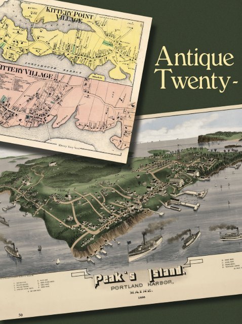
Antique Maps for the Twenty-first Century - Janetmendelsohn.com
Antique Maps for the Twenty-first Century - Janetmendelsohn.com
Antique Maps for the Twenty-first Century - Janetmendelsohn.com

You also want an ePaper? Increase the reach of your titles
YUMPU automatically turns print PDFs into web optimized ePapers that Google loves.
50<br />
<strong>Antique</strong><br />
<strong>Twenty</strong>-
<strong>Maps</strong> <strong>for</strong> <strong>the</strong><br />
First <strong>Century</strong><br />
BY JANET MENDELSOHN<br />
Using cutting-edge technology,<br />
Historic MapWorks makes maps<br />
and charts from <strong>the</strong> earliest years<br />
of our country available to anyone<br />
with web access.<br />
CHARLES CARPENTER can turn your <strong>com</strong>puter<br />
into a time machine. All it takes is an address or<br />
<strong>the</strong> latitude and longitude of your house, your greatgrandfa<strong>the</strong>r’s<br />
farm, or <strong>the</strong> local boatyard. On his <strong>com</strong>pany’s<br />
web site, www.historicmapworks.<strong>com</strong>, type <strong>the</strong><br />
location into <strong>the</strong> search box and presto! Links appear<br />
to a multitude of maps, some 250 years old. Enter <strong>the</strong><br />
address of this magazine (43 Mechanic Street, Camden)<br />
to find maps showing <strong>the</strong> streets of Camden in<br />
1860, 1875, and 1884. O<strong>the</strong>r searches bring up bird’s<br />
eye views of towns or charts, including some accented<br />
with illustrations of nineteenth-century ships.<br />
Historic MapWorks, of Westbrook, Maine, used<br />
cutting-edge technology to turn Carpenter’s vast<br />
personal collection of antique maps into a stateof-<strong>the</strong><br />
art, multifunctional research tool. Founded<br />
in 2005, this marriage of past and present has<br />
already produced more than 150,000 images, a<br />
<strong>com</strong>puterized collection that Carpenter says<br />
<strong>for</strong>ms <strong>the</strong> world’s <strong>first</strong> electronic database of<br />
searchable maps of nineteenth and early twentieth<br />
century America.<br />
To Charles Carpenter (right, above), antique<br />
maps, charts, and atlases are more than pretty<br />
visual objects—<strong>the</strong>y are time lines in <strong>the</strong><br />
development of our country.<br />
photos at right by Janet Mendelsohn. All o<strong>the</strong>rs courtesy Historic MapWorks<br />
51
Boston, Massachusetts, be<strong>for</strong>e <strong>the</strong> shallows around <strong>the</strong> peninsula were filled in,<br />
from an old French atlas.<br />
There are maps of<br />
Atlantic City, be<strong>for</strong>e<br />
and after casino<br />
construction, and maps<br />
depicting <strong>the</strong> Boston Fens<br />
as mostly swampland,<br />
<strong>the</strong>n as a planned<br />
neighborhood, and <strong>the</strong>n<br />
with construction under<br />
way <strong>for</strong> Fenway Park.<br />
In <strong>the</strong> <strong>com</strong>pany’s Westbrook headquarters,<br />
previously <strong>the</strong> offices of Portland<br />
Glass, hundreds of years converge.<br />
There are glass divider walls and contemporary<br />
cubicles with <strong>com</strong>puter desks,<br />
giant flat-bed scanners, and high-speed<br />
printers that use archival inks that should<br />
last 100 years. A staff of 15 <strong>com</strong>puter programmers,<br />
researchers, sales reps, and<br />
technicians works surrounded by art<br />
deco floor lamps and handsome old<br />
maps of Casco Bay and points west. Masters<br />
of high-tech wizardry, <strong>the</strong>y restore<br />
centuries-old pages carefully detached<br />
from aged atlases that rest in stacks on<br />
tables in each room. Brown-tinged sheets<br />
of paper fill <strong>the</strong> heavy volumes that are<br />
bound in gold-tooled brown, russet, and<br />
black lea<strong>the</strong>r. Most of <strong>the</strong> atlases contain<br />
cadastral maps that show boundaries and<br />
ownership of land. They document <strong>the</strong><br />
history of America’s westward expansion.<br />
Many were unear<strong>the</strong>d in barns, attics,<br />
bookshops, and dusty closets in county<br />
offices out west or in sou<strong>the</strong>rn states, as<br />
well as in New England.<br />
On Maine’s brightest days, when sunlight<br />
threatens to fade <strong>the</strong> fragile old<br />
pages, HMW staffers pull down <strong>the</strong><br />
shades and dim <strong>the</strong> lights. Everyone<br />
seems to have more than a casual interest<br />
in <strong>the</strong> work at hand. Who can blame<br />
<strong>the</strong>m when <strong>the</strong> product of <strong>the</strong>ir labor is<br />
<strong>the</strong> restoration of <strong>the</strong>se beautiful old<br />
maps? Here are maps of Atlantic City,<br />
be<strong>for</strong>e and after casino construction;<br />
three maps depict <strong>the</strong> Boston Fens as<br />
mostly swampland, <strong>the</strong>n as a planned<br />
neighborhood, and <strong>the</strong>n with construction<br />
underway <strong>for</strong> Fenway Park. World<br />
Series baseball fans were still to <strong>com</strong>e.<br />
Historic MapWorks is a lucrative<br />
labor of love <strong>for</strong> Carpenter, a mustached<br />
entrepreneur with a PhD in microbiology<br />
and a 30-year passion <strong>for</strong> antique<br />
maps and rare books. That passion has<br />
led him to amass what he says is <strong>the</strong> premier<br />
private cadastral map collection in<br />
<strong>the</strong> world.<br />
After living in five states, from Alaska<br />
to New York, he arrived in Maine to work<br />
at Idexx Laboratories of Westbrook, <strong>the</strong><br />
international developer of technologybased<br />
products and services <strong>for</strong> veterinary<br />
medicine and food and water safety,<br />
where he still is employed as a longtime<br />
research fellow. He holds 18 patents in<br />
biochemistry and <strong>for</strong> medical devices.<br />
Growing this business seems to <strong>com</strong>e<br />
naturally to Carpenter, who thinks big<br />
where o<strong>the</strong>rs think small. A few years<br />
ago, he challenged himself to rebuild his<br />
41-foot Morgan sailboat, Texas, after it<br />
sank in a hurricane. He built a custom<br />
interior, and all exterior hatches and<br />
trim; installed a new engine and systems;<br />
and re-rigged <strong>the</strong> boat, all be<strong>for</strong>e learning<br />
to sail. Carpenter <strong>the</strong>n sailed Texas<br />
over a three-year span, beginning in<br />
2001, to Bermuda, Haiti, Cuba, Miami,<br />
and up <strong>the</strong> coast to Atlantic City, New<br />
York, and back home to Portland.<br />
52 MAINE BOATS, HOMES & HARBORS | June / July 2008 | Issue 100
Carpenter can be a difficult man to<br />
read. When we spoke, he was reserved,<br />
barely smiling even as he intently<br />
described <strong>the</strong> enthusiasms that drive his<br />
life: photography, biochemical research,<br />
raising money to build playgrounds <strong>for</strong><br />
children in Haiti and Afghanistan, and<br />
amassing a vast library on <strong>the</strong> history of<br />
science that includes fifteenth-century<br />
incunabula (among <strong>the</strong> earliest printed<br />
books) and writings of Galileo. Some day,<br />
he said, he will donate his map collection<br />
to <strong>the</strong> University of Sou<strong>the</strong>rn Maine’s<br />
Osher Map Library. Late last year, HMW<br />
signed an exclusive <strong>com</strong>mercial agreement<br />
with <strong>the</strong> library, adding 2,000 of <strong>the</strong><br />
library’s antiquarian maps dating from<br />
<strong>the</strong> 15th century to HMW’s resources.<br />
Mat<strong>the</strong>w Edney, Osher Professor in<br />
<strong>the</strong> History of Cartography at USM, said<br />
county maps and atlases are <strong>the</strong> single<br />
best point of access into <strong>the</strong> geographical<br />
intersection of American society, land<br />
ownership, agriculture, and industry in<br />
<strong>the</strong> 1800s.<br />
“The nineteenth century was a period<br />
of intense urbanization, industrialization,<br />
and economic change,” said<br />
Edney. “These maps and atlases cover<br />
much of <strong>the</strong> country, and many areas<br />
were remapped twice or even three<br />
times, so <strong>the</strong>se maps can provide a firm<br />
basis <strong>for</strong> longitudinal studies. They often<br />
provide a wealth of in<strong>for</strong>mation about<br />
historic architecture and local social<br />
organization, and <strong>the</strong>y are a genealogist’s<br />
delight. Carpenter’s collection of <strong>the</strong>se<br />
crucial historic documents is almost certainly<br />
<strong>the</strong> most extensive in private<br />
hands, and perhaps <strong>the</strong> largest outside of<br />
<strong>the</strong> Library of Congress. The gift of <strong>the</strong><br />
collection to <strong>the</strong> Osher Map Library<br />
would be a truly significant addition to<br />
<strong>the</strong> cultural resources of USM and <strong>the</strong><br />
people of Maine.”<br />
Indeed, Historic MapWorks’s web<br />
site is a cartographer’s candy store with<br />
treats <strong>for</strong> those who study family history<br />
as well as <strong>for</strong> urban planners, historians,<br />
environmentalists, and you and me.<br />
Wander its virtual aisles and get lost in<br />
<strong>the</strong> past or pick up all kinds of facts<br />
about American economic development<br />
and changes in demographic patterns as<br />
<strong>the</strong> young country grew.<br />
The web site is a good place to con-<br />
<strong>Antique</strong> <strong>Maps</strong> <strong>for</strong> <strong>the</strong><strong>Twenty</strong>-First <strong>Century</strong><br />
duct business, too, as it facilitates property<br />
title searches that can go back generations.<br />
To retrace <strong>the</strong> history of 271<br />
Park Avenue in Portland, now Hadlock<br />
Field, <strong>the</strong> home to <strong>the</strong> Sea Dogs baseball<br />
team, simply type in that address and<br />
you are instantly connected to a list of 82<br />
maps. Sixteen are address-specific with<br />
thumbnail images of each map. Ano<strong>the</strong>r<br />
48 link to general maps of Portland<br />
and 18 link to general atlases in which<br />
more data can be found. You can study<br />
<strong>the</strong> Portland Eastern Cemetery, or order<br />
a reproduction of an individual map <strong>for</strong><br />
$29.99 to $150, with nearly all under<br />
$40. They are typically processed and<br />
shipped within 48 hours.<br />
Genealogy is often cited as <strong>the</strong> second<br />
biggest hobby in America. Carpenter<br />
has trademarked <strong>the</strong> term “Residential<br />
Genealogy” and is positioning<br />
HMW’s database as a research site <strong>for</strong><br />
enthusiasts attempting to <strong>com</strong>plete<br />
branches on <strong>the</strong>ir family trees. Since <strong>for</strong>mer<br />
property owners’ names are clearly<br />
marked on many of <strong>the</strong>se maps, <strong>the</strong><br />
database can be a boon to those looking<br />
<strong>for</strong> <strong>the</strong>ir <strong>for</strong>efa<strong>the</strong>rs and -mo<strong>the</strong>rs<br />
who established businesses and built<br />
homes across <strong>the</strong> country. He also anticipates<br />
business from home owners,<br />
urban planners, and real estate professionals.<br />
“These old maps <strong>com</strong>bine fine art,<br />
mostly hand-painted, with <strong>the</strong> history of<br />
a place,” says Carpenter. “They are a<br />
wonderful connection to people who<br />
lived on a farm in Iowa or attended<br />
church on a country road that still<br />
exists.”<br />
Cadastral maps once were a cottage<br />
industry. In <strong>the</strong> 1860s, traveling surveyors<br />
sold <strong>the</strong> atlases <strong>for</strong> ten dollars apiece,<br />
a hefty price at <strong>the</strong> time. Itinerant mapmakers<br />
would use wheelbarrows as<br />
pedometers to measure real estate<br />
parcels; <strong>the</strong>y would record property<br />
owners’ names, lot sizes, and area buildings.<br />
Later, <strong>the</strong> maps <strong>the</strong>y created were<br />
hand-painted in watercolor by women<br />
paid one dollar a day to work at home.<br />
For additional fees as high as $100,<br />
homeowners could have a sketch of <strong>the</strong>ir<br />
house, or <strong>the</strong>ir own portrait added.<br />
Mapmaking was a sort of vanity press of<br />
its day.<br />
Maine is <strong>the</strong> only state in <strong>the</strong> nor<strong>the</strong>ast<br />
without full coverage by <strong>the</strong> antiquarian<br />
atlases, says Carpenter. That’s<br />
because <strong>the</strong> atlases were produced as<br />
<strong>com</strong>mercial ventures. Salesmen went<br />
where sales prospects were good, and <strong>the</strong><br />
population of Maine was too small a<br />
market. One exception was Aroostook<br />
County, although Carpenter doesn’t<br />
know why.<br />
Cities were mapped <strong>first</strong>, and as plots<br />
of land around <strong>the</strong>m were sold, <strong>the</strong>ir<br />
boundaries were added. At one time, as<br />
many as 25 <strong>com</strong>panies criss-crossed <strong>the</strong><br />
country making <strong>the</strong> maps <strong>com</strong>piled later<br />
in <strong>the</strong> atlases. Populated areas also had<br />
fire protection and insurance maps. The<br />
deep South after <strong>the</strong> Civil War, as well as<br />
Nevada and Utah pre-statehood, rarely<br />
were recorded in atlases but were covered<br />
by large county wall maps, government<br />
land patent maps, and state-initiated<br />
mapping projects. Altoge<strong>the</strong>r, <strong>the</strong>se<br />
maps and atlases reveal land usage over<br />
time, including stockyards, factories,<br />
refineries, and granaries, which makes<br />
<strong>the</strong>m useful today <strong>for</strong> environmental<br />
property analysis.<br />
Historic MapWorks began in <strong>the</strong><br />
most casual of ways. One day in a small<br />
New Hampshire bookstore, Carpenter<br />
picked up an old Maine atlas that<br />
reminded him of a past purchase, a Scarborough<br />
map, dated 1871 (his home was<br />
built at about that time). Like o<strong>the</strong>r<br />
cadastral maps, this one was illustrated<br />
with houses, churches, cemeteries, and<br />
stores; symbols indicated woods and<br />
orchards. Carpenter had studied countless<br />
similar maps over <strong>the</strong> years, but this<br />
time it occurred to him that beautiful<br />
old maps reveal much more than <strong>for</strong>mer<br />
roads and railroad tracks. They chronicle<br />
America’s past and offer a gold mine<br />
of useful in<strong>for</strong>mation. Suddenly he saw<br />
a business opportunity.<br />
The <strong>com</strong>pany that was born currently<br />
owns about 200,000 North American<br />
cadastral maps and views printed<br />
from 1885 to 2005. Three-quarters have<br />
been scanned and are available on <strong>the</strong><br />
<strong>com</strong>pany’s web site, which makes it <strong>the</strong><br />
largest digitized online collection in <strong>the</strong><br />
world. Over 16,000 items are geocoded,<br />
meaning searchable by Global Position<br />
System (GPS) coordinates. Two years<br />
www.maineboats.<strong>com</strong> | MAINE BOATS, HOMES & HARBORS 53
<strong>Antique</strong> <strong>Maps</strong> <strong>for</strong> <strong>the</strong><strong>Twenty</strong>-First <strong>Century</strong><br />
ago, HMW purchased Title Atlas Company,<br />
which gained <strong>the</strong>m copyright to<br />
thousands of Midwest cadastral maps<br />
published between 1963 and 2005.<br />
Carpenter’s collection also includes<br />
navigational charts and individual antiquarian<br />
maps, which did not appear in<br />
atlases and have be<strong>com</strong>e hard to find. He<br />
said that over <strong>the</strong> past five years, atlas<br />
prices have skyrocketed, if <strong>the</strong>y turn up<br />
at all in antique shops or estate sales.<br />
“These maps also have a relatively<br />
high mortality rate,” said USM’s Professor<br />
Edney, “especially <strong>the</strong> wall maps, so<br />
<strong>the</strong>ir preservation by Mr. Carpenter is<br />
very much to be praised.”<br />
Historic MapWorks plans to create a<br />
special collection of celestial maps, battle<br />
plans, and such rarities as ethnographic<br />
depictions from <strong>the</strong> 1860s. But grabbing<br />
<strong>the</strong> gold ring will require ano<strong>the</strong>r round<br />
of financing, enabling <strong>the</strong> <strong>com</strong>pany to<br />
create an “antiquarian world map” <strong>com</strong>bining<br />
200,000 individual maps.<br />
The antiquarian world map will be<br />
like an antique Google Earth, <strong>the</strong> pop-<br />
ular Internet source <strong>for</strong> current geographic<br />
in<strong>for</strong>mation, says Carpenter.<br />
“Like Google Earth, our database spans<br />
<strong>the</strong> country and eventually will be international.<br />
But unlike <strong>the</strong>irs, our database<br />
travels through time.” Users would be<br />
able to pan and zoom across surfaces of<br />
<strong>the</strong> earth as well as move from one century<br />
to <strong>the</strong> next. An impressive example<br />
of <strong>the</strong> <strong>com</strong>pany’s technology hangs in<br />
<strong>the</strong> <strong>com</strong>pany’s office. Pieced toge<strong>the</strong>r<br />
from smaller maps, it is a map taller than<br />
a grown man: <strong>the</strong> world’s <strong>first</strong> <strong>com</strong>posite<br />
map of New York’s crown jewel, Central<br />
Park, under construction in 1867.<br />
Digitizing maps begins when<br />
employees gently unbind atlases. They<br />
remove leaves, bugs, and any mementos<br />
tucked inside, <strong>the</strong> residue of decades in<br />
old barns. “Many of <strong>the</strong> books had a<br />
hard life in offices with smokers, or<br />
<strong>the</strong>y’re dusty from storage and often<br />
smudged” says Jason Braley, data manager.<br />
Individual maps are scanned in 24inch<br />
or 42-inch <strong>for</strong>mat, in full color, at<br />
300 dpi (dots per inch). Using technolo-<br />
gy developed by HMW, <strong>the</strong> maps are<br />
cleaned <strong>for</strong> clarity. Artificial distractions,<br />
such as tears and ink spots, are removed.<br />
Watermarks and o<strong>the</strong>r antique qualities<br />
are retained to bring <strong>the</strong> map as close as<br />
possible to its original state.<br />
“People like to see evidence of time<br />
as well as find family names on <strong>the</strong><br />
maps,” says Braley.“We delete handwritten<br />
scribbles that were added later, things<br />
that detract from a map you might want<br />
to hang in your home or office.”<br />
Combining XMAP software from<br />
DeLorme, ano<strong>the</strong>r Maine <strong>com</strong>pany, and<br />
a software program also developed by<br />
HMW, Geographic In<strong>for</strong>mation System<br />
(GIS) coordinates are added next. This<br />
gives anyone <strong>the</strong> ability to conduct<br />
research online by entering <strong>the</strong> latitude<br />
and longitude of two intersecting streets,<br />
or of a landmark that still exists, linking<br />
it to <strong>the</strong> same address a century or more<br />
ago. Enter Latitude 42.35978 N, Longitude<br />
71.06617 W <strong>for</strong> Boston’s Beacon<br />
Hill, <strong>for</strong> example, and up pop 36 maps of<br />
<strong>the</strong> area dating from 1722 to 1938.<br />
54 MAINE BOATS, HOMES & HARBORS | June / July 2008 | Issue 100
The latest feature to go live on <strong>the</strong><br />
<strong>com</strong>pany’s web site is annotation that<br />
points to a specific address, and reverse<br />
annotation providing coordinates that<br />
can be entered into a handheld GPS to<br />
guide <strong>the</strong> user to a precise spot, such as<br />
<strong>the</strong> cemetery where an aunt was buried<br />
or <strong>the</strong> church where one’s grandparents<br />
were married. Carpenter, who has<br />
invested considerable time in ascertaining<br />
intellectual property rights, said that<br />
maps published prior to 1923 by law are<br />
in <strong>the</strong> public domain. Anything after<br />
that year requires extensive copyright<br />
searches to establish <strong>the</strong> ownership and<br />
copyright status.<br />
“The fact that we wrote and own our<br />
software, and own all our data, is key to<br />
our success,” says Carpenter. “We can<br />
build our own <strong>com</strong>mercial models and<br />
not worry about anyone shutting us<br />
down.”<br />
Historic MapWorks is divided into<br />
two business units. A printed products<br />
division involves retail sales of maps and<br />
giftware, both directly from <strong>the</strong> <strong>com</strong>pa-<br />
ny’s headquarters and through a program<br />
of customization with 400 art and<br />
frame galleries. Gift items include<br />
ceramic mugs, hostess trays, coasters,<br />
journals, mouse pads, and jigsaw puzzles<br />
printed with maps of selected U.S.<br />
landmarks, sports stadiums, golf courses,<br />
and academic institutions. A few are<br />
in Maine.<br />
The second unit, on which <strong>the</strong><br />
<strong>com</strong>pany’s finances principally depend,<br />
involves <strong>com</strong>mercial applications<br />
through licensing and subscription<br />
services <strong>for</strong> <strong>the</strong> use of <strong>the</strong> database by<br />
researchers, genealogists, and o<strong>the</strong>rs.<br />
The <strong>first</strong> licensing deal was inked<br />
recently with <strong>the</strong> parent <strong>com</strong>pany of<br />
ancestry.<strong>com</strong>, a ten-year-old web site<br />
that helps amateur genealogists build<br />
<strong>the</strong>ir family tree and integrate <strong>the</strong>ir<br />
data with that of 500,000 o<strong>the</strong>r family<br />
trees and records containing five billion<br />
names. In addition to making <strong>the</strong> map<br />
database available to ancestry.<strong>com</strong>’s<br />
registered users, HMW’s individual<br />
printed maps and giftware will be mar-<br />
keted through <strong>the</strong> site. Currently,<br />
HMW is also licensed to ProQuest, a<br />
vast database <strong>for</strong> libraries and<br />
researchers worldwide, and has supply<br />
agreements with National Geographic,<br />
Light Depot, and EDR (Environmental<br />
Data Resources).<br />
If things go right, Carpenter said,<br />
future projects will tap into <strong>the</strong> huge<br />
consumer market <strong>for</strong> online video<br />
games. Toward that end, <strong>the</strong> <strong>com</strong>pany<br />
has already filed a provisional patent to<br />
protect <strong>the</strong> use of real historical geographic<br />
maps <strong>for</strong> gaming.<br />
All that, however, is in <strong>the</strong> future.<br />
Today—right now—you can go to a <strong>com</strong>puter,<br />
type www.historicmapworks.<strong>com</strong><br />
into <strong>the</strong> address window of your browser,<br />
and travel back in time. With a bit of<br />
luck and imagination, you’ll see <strong>the</strong> farm<br />
field or street where your house was later<br />
built.<br />
Contributing Editor Janet Mendelsohn studies<br />
old maps of her neighborhoods in Kittery Point,<br />
Maine, and Somerville, Massachusetts.<br />
MAINE BOATS,HOMES & HARBORS SHOW Exhibitor . August 8–10, 2008 | www.maineboats.<strong>com</strong> 55