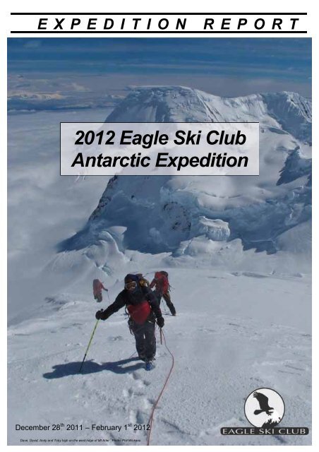
2012 Eagle SKi Club Antarctic Expedition Report VERSION - UIAA
2012 Eagle SKi Club Antarctic Expedition Report VERSION - UIAA
2012 Eagle SKi Club Antarctic Expedition Report VERSION - UIAA

You also want an ePaper? Increase the reach of your titles
YUMPU automatically turns print PDFs into web optimized ePapers that Google loves.
EXPEDITION REPORT<br />
<strong>2012</strong> <strong>Eagle</strong> Ski <strong>Club</strong><br />
<strong>Antarctic</strong> <strong>Expedition</strong><br />
December 28 th 2011 – February 1 st <strong>2012</strong><br />
Dave, David, Andy and Toby high on the west ridge of Mt Ader Photo: Phil Wickens
Contents<br />
SUMMARY ...................................................................1<br />
Summary Itinerary..................................................1<br />
Mountains Climbed ................................................1<br />
INTRODUCTION ............................................................3<br />
MEMBERS ...................................................................4<br />
SAILING SOUTH............................................................5<br />
SEA-ICE CONDITIONS ...................................................6<br />
WIENCKE ISLAND .........................................................7<br />
Access & Travel .....................................................7<br />
Jabet Peak .............................................................8<br />
ANVERS ISLAND ...........................................................9<br />
Access, Travel and Camp Sites.............................9<br />
Mt Agamemnon....................................................10<br />
PARADISE HARBOUR ..................................................11<br />
Access, Travel and Camp Sites...........................11<br />
Mt Banck..............................................................12<br />
Bruce Island .........................................................13<br />
CIERVA COVE ............................................................14<br />
Access, Travel and Camp Sites...........................14<br />
Mount Cornu ........................................................16<br />
Un-named Peak 2 (‘Madonna’s Peaks’) ..............17<br />
Mt Ader ................................................................18<br />
Un-named Peak 3 (‘<strong>Eagle</strong> Dome’) .......................19<br />
Un-named Peak 4 (‘Spirit Peak’)..........................20<br />
Un-named Peak 5 (‘Amundsen East Peak’) ........21<br />
Un-named Peak 6 (‘Missing Peak’)......................22<br />
Un-named Peak 7 (‘Central Peak’) ......................23<br />
RETURN JOURNEY .....................................................25<br />
WEATHER..................................................................26<br />
COMMUNICATIONS .....................................................27<br />
CLOTHING, EQUIPMENT AND FOOD..............................27<br />
Clothing and Equipment.......................................27<br />
Food.....................................................................28<br />
PLANNING AND PERMITS.............................................28<br />
FINANCE....................................................................29<br />
BIBLIOGRAPHY...........................................................30<br />
Books ...................................................................30<br />
<strong>Expedition</strong> <strong>Report</strong>s...............................................30<br />
Maps ....................................................................30
Summary<br />
The <strong>Eagle</strong> <strong>Club</strong> <strong>Antarctic</strong> <strong>Expedition</strong> sailed to the <strong>Antarctic</strong> Peninsula aboard<br />
Spirit of Sydney, where we climbed and skied a total of 13 summits in the area<br />
east of Cierva Cove, Paradise Harbour and Anvers Island.<br />
Summary Itinerary<br />
TOTAL DAYS 35 DATE LOCATION ACTIVITY<br />
Sailing 11 December 26-29 Ushuaia, ARGENTINA Preparations<br />
Climbing 10 Dec 30 -Jan 2 Drake Passage Sailing<br />
Ski Approach 6 January 3 Port Lockroy Climbing, Rest, Preparation<br />
Rest 4 January 4-10 Anvers Island Climbing/Skiing<br />
Lie-up 4 January 11-12 Palmer Station Kayaking, Rest<br />
January 13-15 Paradise Harbour Climbing/Skiing/Kayak<br />
January 16-25 Cierva Cove Climbing/Skiing<br />
January 26-27 Deception Island Hiking<br />
January 28-31 Drake Passage Sailing<br />
February 1 Puerto Williams Hiking<br />
February 2 Beagle Channel Sailing<br />
Mountains Climbed<br />
MOUNTAIN REGION POSITION DESCRIPTION<br />
Mt Agamemnon<br />
(2594m)<br />
Unnamed Peak 1 NE<br />
of Mt Moberly<br />
(c.1400m)<br />
Bruce Island<br />
(324m)<br />
Mt Cornu<br />
(1714m)<br />
Unnamed Peak 2<br />
‘Madonna’s Peaks’<br />
(c.1448m)<br />
Mt Ader<br />
(1775m)<br />
Unnamed Peak 3<br />
‘<strong>Eagle</strong> Dome’<br />
(c.2230m)<br />
Unnamed Peak 4<br />
‘Spirit Peak’<br />
(1503m)<br />
Unnamed Peak 5<br />
‘Amundsen East’<br />
(1114m)<br />
Unnamed Peak 6<br />
‘Missing Peak’<br />
(c.1748m)<br />
Unnamed Peak 7<br />
‘Central Peak’<br />
(c.1300m)<br />
Unnamed Peak 8<br />
‘Cierva Nunatak’<br />
(543m)<br />
Mt Banck<br />
(710m)<br />
Jabet Peak<br />
(552m)<br />
Anvers<br />
Island<br />
Anvers<br />
Island<br />
Paradise<br />
Harbour<br />
Cierva<br />
Cove<br />
Cierva<br />
Cove<br />
Cierva<br />
Cove<br />
Cierva<br />
Cove<br />
Cierva<br />
Cove<br />
Cierva<br />
Cove<br />
Cierva<br />
Cove<br />
Cierva<br />
Cove<br />
Cierva<br />
Cove<br />
Paradise<br />
Harbour<br />
Wiencke<br />
Island<br />
64°38.122'S<br />
063°30.543'W<br />
64° 43.426'S<br />
063° 38.805'W<br />
64°53.840'S<br />
063°07.073'W<br />
64°10.056'S<br />
060°37.700'W<br />
64°09.443’S<br />
060°40.582’W<br />
64°10.607’S<br />
060°31.205’W<br />
64°14.421’S<br />
060°34.119’W<br />
64°10.075'S<br />
060°33.959'W<br />
64°13.759’S<br />
060°50.386’W<br />
64°14.803’S<br />
060°41.826’W<br />
64°14.233'S<br />
060°46.665'W<br />
64°10.562'S<br />
060°53.982'W<br />
64°55.350'S<br />
063°03.360'W<br />
64°48.883'S<br />
063°27.791'W<br />
NW ridge. PD. Descended on ski in its entirety.<br />
Possible 2 nd ascent. 9/1/12<br />
Turned back c.100m below summit via west face. F.<br />
10/1/12<br />
Possible second ascent via north face. F. Full ski<br />
descent. 15/1/12<br />
First ascent via WSW Face. F. Full ski descent.<br />
19/1/12<br />
First ascent via east ridge. F. Ski descent from 150m<br />
below summit.19/1/12<br />
First ascent via west ridge. PD. Ski descent from<br />
100m below summit. PD. 20/1/12<br />
First ascent via north spur. PD+. Full ski descent.<br />
22/1/12<br />
First ascent via west then north sides. AD. Ski descent<br />
from 150m below summit. 22/1/12<br />
First ascent via north-west side. F. Full ski descent.<br />
23/1/12<br />
First ascent via north-west side. F. Full ski descent.<br />
24/1/12<br />
First ascent via north face. PD. Full ski descent.<br />
25/1/12<br />
Ascent via south-west face and traverse of both<br />
summits. F. Full ski descent.<br />
North face. PD. Descended on ski. 13/1/12<br />
SW face and south ridge. PD. 3/1/12
NOTE: All heights given in this report are those measured by the expedition team. They are<br />
the average readings of two Garmin hand-held GPS units and one Suunto altimeter.<br />
2
Introduction<br />
Our plan was to sail to <strong>Antarctic</strong>a by yacht to independently explore and climb,<br />
using skis, the mountains surrounding the northeastern fjords of Marguerite<br />
Bay. If heavy sea-ice prevented access to Marguerite Bay our back-up plan<br />
included unclimbed mountains north of the Lemaire Channel, on Anvers<br />
Island, and the area east of Cierva Cove.<br />
Map 1. The <strong>Antarctic</strong> Peninsula<br />
We chartered the yacht Spirit of Sydney, which is owned and skippered by<br />
Cath Hew and Darrel Day, who have been sailing to <strong>Antarctic</strong>a every year<br />
since 2003. Spirit is ideal as an expedition support vessel being strong, fast<br />
and comfortable, and has plenty of storage space for expedition equipment.<br />
3
Members<br />
The expedition was open to all members of the <strong>Eagle</strong> Ski <strong>Club</strong> with suitable<br />
experience. The team that was assembled had a large amount of ski<br />
mountaineering experience, much of which was of an expedition nature in<br />
remote areas. The members were:<br />
Phil Wickens, (Leader)<br />
NATIONALITY: British<br />
Toby Johnson<br />
NATIONALITY: British<br />
Lucy Bound<br />
NATIONALITY: British<br />
Dave Smith<br />
NATIONALITY: British<br />
David Williams<br />
NATIONALITY: British<br />
4<br />
Steve Gould<br />
NATIONALITY: British<br />
Darrel Day (Skipper)<br />
NATIONALITY: Australian<br />
Andy Collins<br />
NATIONALITY: British<br />
Roger Upton<br />
NATIONALITY: British<br />
Cath Hew (Skipper)<br />
NATIONALITY: Australian
Sailing South<br />
Spirit of Sydney was designed by Ben Lexcen for Ian Kiernan to sail solo<br />
around the world in the 1986 B.O.C. Challenge Race of 1986. With her strong<br />
aluminium construction and watertight bulkheads she was suitable for high<br />
latitude expedition sailing, and made her first voyage into <strong>Antarctic</strong> waters in<br />
1994/5. She has returned every summer since, and has been meticulously<br />
maintained and improved.<br />
Sailing across Drake Passage Photo: Phil<br />
Wickens<br />
5<br />
Cath, Darrel and Phil arrived in<br />
Ushuaia early to prepare the yacht<br />
and purchase food and supplies,<br />
and once the rest of the team<br />
arrived everything was loaded onto<br />
the yacht. Late arrival of missing<br />
baggage, and then strong winds,<br />
delayed departure by 2 days. Once<br />
paperwork and formalities were<br />
completed we decided to make the<br />
most of a short but ideal weather<br />
window. Rather than stopping at Puerto Williams for a night, we headed<br />
straight out into the Drake Passage on December 30 th .<br />
Each member operated in a rolling watch system with 3 hours on, 6 hours off,<br />
so with 10 of us, there were always at least 3 people on watch. The handover<br />
times were staggered such that one person changed every hour, providing<br />
continuity of operation and variety of company. Once Cape Horn was passed<br />
the swell increased, and seasickness began to take its toll amongst a few of<br />
the members. We were fortunate in that conditions remained favourable and<br />
the sailing was relatively straightforward. With the autopilot running there was<br />
little to do other than reef, unfurl and trim sails, keep an eye out for hazards,<br />
maintain the ship’s log, and prepare drinks and meals. At all times the birds of<br />
the southern oceans – the albatrosses, cape petrels and giant petrels,<br />
remained our constant companions, endlessly following our stern.<br />
Once the <strong>Antarctic</strong> Convergence<br />
was crossed on the third day,<br />
where the cold polar waters meet<br />
the warmer temperate waters, the<br />
temperature dropped considerably.<br />
At the same time the wind dropped<br />
almost completely and so we<br />
motor-sailed the remaining distance<br />
to <strong>Antarctic</strong>a, making landfall off the<br />
southern tip of Anvers Island early<br />
on January 3 rd November 29 th after Andy, Steve and Dave on watch Photo: Phil Wickens<br />
4 days in the Drake Passage. We then headed to Port Lockroy, which was<br />
established in 1944 as the first British <strong>Antarctic</strong> Base, and is now a wonderful<br />
museum and gift shop run by the UK <strong>Antarctic</strong> Heritage Trust, for 2 days’ rest.
Sea-Ice Conditions<br />
Prior to the expedition we had been keeping a careful watch on the sea-ice<br />
conditions in Marguerite Bay and the west side of the <strong>Antarctic</strong> Peninsula.<br />
Although in recent years much of the winter ice has usually cleared out of<br />
Marguerite Bay by January, during this season (2011-12) the ice remained<br />
heavy in Marguerite Bay and as far north as the Lemaire Channel until much<br />
later in the season. Figure 1 shows how extensive this ice was on December<br />
28 th 2011.<br />
Figure 1. Envisat ASAR WSM image showing sea-ice conditions on December 28 th 2011.<br />
Since this density of ice was impossible for Spirit of Sydney to safely<br />
penetrate anywhere south of the Lemaire Channel, we focussed on more<br />
northerly venues. Since a settled period of good weather seemed imminent,<br />
we decided to initially focus on the peaks of Anvers Island, which is close to<br />
Port Lockroy. We then spent a few days in Paradise Harbour before heading<br />
north to Cierva Cove, where very little exploration of the mountains has<br />
previously taken place.<br />
6
Wiencke Island<br />
Access & Travel<br />
We anchored ourselves in Port Lockroy, immediately north-east of Goudier<br />
Island and beneath the confluence of the Harbour and Thunder Glaciers.<br />
Access to the glaciers is via one of several straight-forward glacial ramps that<br />
extend from rocky shores, or from Dorian Bay. These glaciers are moderately<br />
crevassed above the ice cliffs and below the flanks of Jabet Peak and the<br />
Wall Range.<br />
Map 2. Map of Wiencke Island, highlighting Port Lockroy and Jabet Peak<br />
The mountains around Port Lockroy are some of the most commonly visited<br />
and regularly climbed on the <strong>Antarctic</strong> Peninsula. We stopped here only briefly<br />
to relax after crossing the Drake Passage, and made an ascent of one peak<br />
that has had numerous ascents. For further details about climbing in this area<br />
see the report of the 2005 British <strong>Antarctic</strong> <strong>Expedition</strong> (MEF Ref 05/11).<br />
7
Jabet Peak<br />
(552m, Minor Peak)<br />
Named after Jacques Jabet, boatswain of Charcot’s ship ‘Français’, this small<br />
peak is at the SW end of the ridge that extends from Noble Peak and which<br />
overlooks Dorian Bay. The SW face has had numerous ascents by previous<br />
expeditions.<br />
SUMMARY<br />
Route: Ascended via the SW face and S ridge (PD).<br />
Date: 3/1/12<br />
Personnel: Phil Wickens, Andy Collins, Toby Johnson, Lucy Bound, Steve Gould, Roger<br />
Upton, Dave Smith, David Williams<br />
DETAILS<br />
Jabet Peak provided an<br />
opportunity to test our<br />
equipment, take in a summit<br />
and stretch our legs after the<br />
crossing of Drake Passage.<br />
The summit is a great<br />
vantage point, and its SW<br />
face gives a good ski ascent<br />
and descent (max 30°).<br />
Approach was from a steep<br />
snow-slope directly north of<br />
Port Lockroy that leds directly<br />
The summit ridge of Jabet Peak Photo: Phil Wickens<br />
Approaching Jabet Peak from the south-west Photo: Phil Wickens<br />
8<br />
to the old aircraft skiway.<br />
From here the snowy bowl<br />
that forms the SW face was<br />
easy to reach.<br />
This was climbed and the<br />
slope above traversed northeastwards<br />
to reach the edge<br />
a wind-scoop below the<br />
summit ridge. The windscoop<br />
was turned on the right and a<br />
short gully climbed on foot to<br />
reach the summit ridge at its<br />
southern-most point. A<br />
beautiful ridge-traverse then<br />
led airily to the summit.
Anvers Island<br />
Access, Travel and Camp Sites<br />
In common with most locations on the <strong>Antarctic</strong> Peninsula, access to Anvers<br />
Island is difficult because of its coastline of unstable and insurmountable icecliffs.<br />
One of the few places where access is via a relatively straightforward<br />
glacial ramp is Access Point, which lies near the southern tip of the island<br />
immediately west of Mt Hindson.<br />
Map 3. Map showing our route to Mt Agamemnon from Access Point, showing camps.<br />
Despite fairly calm sea conditions and a number of landing options that face a<br />
variety of directions, landing by inflatable boat was still made tricky by<br />
moderate swell. We then headed up the low-angled glacial ramp, towing sleds,<br />
eastwards towards Mt Hindson in order to avoid the worst of the crevassing.<br />
Although a number of crevasses cut across the slope, they were relatively<br />
easy to cross. At a height of about 250m the angle eased further, the snow<br />
cover became more substantial and the crevassing was less obvious, and so<br />
we headed north towards the entrance to the Hooper Glacier. After camping<br />
below the west face of Mt William we continued northwards and in thick cloud<br />
to below the west face of Mt Agamemnon, moving our camp after a day of lieup<br />
in bad weather to below the lowest point of the NW ridge (Menelaus Ridge)<br />
of Mt Agamemnon.<br />
9
Mt Agamemnon<br />
(2594m)<br />
Mt Agamemnon, which was previously known as the south summit of Mt<br />
Francais, lies at the southwestern end of the long, high ridge that extends<br />
from Mt Francais. It was surveyed by the Falkland Islands Dependencies<br />
Survey in 1944, and named for Agamemnon, Commander in Chief of the<br />
Achaean forces at Troy in Homer's Iliad.<br />
Although the first and only recorded ascent was made by a Chilean<br />
Government survey party led by J. Quinteros on 27 January 1982, it is<br />
possible that Mt Agamemnon was traversed by Hindson, Rennie and Shewry<br />
when they made the first ascent of Mt Francais from the west on 28<br />
November 1955.<br />
SUMMARY<br />
Route: Ascent and ski descent of the the NW (Menelaus) Ridge. PD. Possible 2 nd ascent.<br />
Date: 9/1/12<br />
Personnel:, David Williams, Andy Collins, Toby Johnson, Dave Smith, Roger Upton, Lucy<br />
Bound, Phil Wickens<br />
Mt Agamemnon (left) and Mt Francais (centre) from the south. Route of ascent/descent (Menelaus Ridge) shown in red. Photo: Phil Wickens<br />
DETAILS<br />
After another lie-up day at our camp below the Menelaus Ridge the clouds<br />
started to break up and so, late in the evening of January 8 th , we set off on a<br />
rising traverse up Mt Agamemnon, reaching the crest of the long Menelaus<br />
Ridge shortly after sunset. This was followed easily as it gradually steepened<br />
to about 30° to reach the summit 7 hours after leaving camp.<br />
Since a large bank of stratus cloud was rapidly moving in from the southwest<br />
we did not continue to the<br />
summit of Mt Francais, and by<br />
the time we started our descent<br />
the summits were already partly<br />
obscured. The descent was<br />
made on ski from the summit<br />
and gave an excellent and very<br />
long descent on very good<br />
snow, ranging from soft sastrugi<br />
to knee-deep powder.<br />
When we reached the tents the The final steepening of the Menelaus Ridge of Mt Agamemnon. Photo:<br />
sky had clouded over completely and snow was falling. The remainder of the<br />
day was spent recovering and, with no improvement in the weather forecast,<br />
we headed back towards Access Point the following morning. During the<br />
10
descent we attempted a small summit on the ridge immediately north-east of<br />
Mt Moberly, but turned back approximately 100m below the summit in poor<br />
visibility due to large cornices and an avalanche-prone summit slope.<br />
Paradise Harbour<br />
Access, Travel and Camp Sites<br />
From Anvers Island we sailed to Paradise Harbour. As we entered Paradise<br />
Harbour we were dropped off below the north side of Mt Banck between<br />
Barbard Point and Sturm Cove for a single-day ascent at Mt Banck. After the<br />
ascent we sat out bad weather anchored in a small and very sheltered cove<br />
on the north side of Skontorp Cove.<br />
Map 4. Map of Paradise Harbour, showing Skontorp Cove (anchorage) and peaks climbed.<br />
During our sail in to Paradise Harbour we had spotted a good ski route up the<br />
peak on Bruce Island, which had no previous record of ascent. We therefore<br />
landed here as we left Paradise Harbour en route to Cierva Cove. The tricky<br />
landing was in a small and steep-sided inlet on the northern tip of the island,<br />
and the only spot that was sufficiently sheltered to land. After landing on a<br />
small rocky platform we hoisted the inflatable boat up the 45° snow-slope<br />
above and headed up to easier ground to put on skis.<br />
11
Mt Banck<br />
(710m)<br />
Mt Banck lies on the south side of, and at the entrance to, the Ferguson<br />
Channel, which forms the western entrance to Paradise Harbour. It was<br />
originally charted as an island on 10 February 1898 by Adrien de Gerlache’s<br />
Belgian <strong>Antarctic</strong> <strong>Expedition</strong>, when a landing was made in the vicinity.<br />
Gerlache named named it Île Banck, probably after a supporter of the<br />
expedition. It is now known to be a distinct mountain on its own small<br />
peninsula.<br />
Mt Banck above Ferguson Channel. Photo: Phil Wickens<br />
DETAILS<br />
As we arrived in Paradise<br />
Harbour, Cath and Darrel<br />
dropped the team off at the<br />
base of the northern slopes of<br />
Mt Banck. A narrow glacial<br />
ramp opened out to broader<br />
slopes, which we followed past<br />
several crevasses and a serac<br />
band. Although the sky was<br />
overcast, visibility remained<br />
sufficient for the ascent.<br />
12<br />
SUMMARY<br />
Route: Ascent via north face. PD.<br />
Descended on ski.<br />
Date: 13/1/12<br />
Personnel: Andy Collins, Toby Johnson,<br />
Lucy Bound, Roger Upton, Dave Smith,<br />
David Williams, Phil Wickens<br />
Mt Banck Ascent photo<br />
during the ascent of Mt Banck. Photo:<br />
The angle again eased and we<br />
traversed to reach the base of<br />
a steep but short headwall.<br />
This was climbed on foot to the summit, which we reached as the clouds<br />
descended and light snow started to fall.<br />
The excellent snow conditions gave an excellent ski descent and we were<br />
soon back at the landing point awaiting a pick-up from the yacht.
Bruce Island<br />
(324m)<br />
Bruce Island lies at the western entrance to the Ferguson Channel, which<br />
leads into Paradise Harbour. The island is the top of a small mountain that<br />
rises abruptly from the sea. Discovered and mapped by the Belgian <strong>Antarctic</strong><br />
<strong>Expedition</strong> of 1897-99, under Lieutenant Adrien de Gerlache, the name was<br />
first used by the Scottish geologist David Ferguson, who made a geological<br />
reconnaissance in this vicinity from the whalecatcher Hanka in 1913. Although<br />
its north-east face is very steep and craggy, the north-east side and north<br />
ridge are glaciated and provide an amenable ski route to the pointed summit.<br />
Bruce Island, as seen from the SE. Route of ascent is out of sight. Photo: Phil Wickens<br />
13<br />
SUMMARY<br />
Route: Possible first ascent via north<br />
face. F. Full ski descent.<br />
Date: 15/1/12<br />
Personnel: Toby Johnson, Lucy<br />
Bound, Roger Upton, Dave Smith,<br />
David Williams, Phil Wickens, Andy<br />
Collins.<br />
DETAILS<br />
From our tricky landing on the northern tip of the island a small wind-scoop led<br />
to the snow-slope that forms the northern end of the northeast face.<br />
This was followed easily without any obvious crevassing, over several rolls, to<br />
the base of the small, pointed and slightly exposed summit.<br />
Nearing the top of Bruce Island. Photo: Phil Wickens<br />
the inflatable boat, which we<br />
lowered to the sea and returned to<br />
Spirit of Sydney so that we could<br />
continue our sail towards Cierva<br />
Cove.<br />
The ski descent, on wind-compacted<br />
snow that had been perfectly softened<br />
by the sun, was so enjoyable that most<br />
of the team climbed skinned back up to<br />
the summit for a second descent. After a<br />
second descent we continued back to<br />
David Williams descending from the summit of Bruce Island. Photo: Phil Wickens Photo: Phil Wickens
Cierva Cove<br />
Access, Travel and Camp Sites<br />
From Paradise Harbour we sailed north to Enterprise Island, where we spent<br />
a night moored against the wreck of the whaling ship Governoren, before<br />
continuing on our way to Cierva Cove.<br />
Despite the proximity of the Argentine base Primavera, exploration of the<br />
mountains surrounding Cierva Cove has been limited to a small number of<br />
day-ascents of minor peaks close to the shore, and the ascent, from Charles<br />
Point, of Pilcher Peak and three other minor peaks in January 1999 by an<br />
Australian team aboard the yacht Tiama. In addition, the un-named peak<br />
immediately west of Un-named Peak 5 was climbed on December 14 th 2011<br />
by the Amundsen <strong>Antarctic</strong> <strong>Expedition</strong>, who also attempted Un-named Peak 4.<br />
The area has numerous peaks up to around 1600m in altitude, and is<br />
overlooked by the 2000m high Detroit Plateau, which forms part of the<br />
<strong>Antarctic</strong> Peninsula and which has several additional domed summits. Two<br />
large glaciers – the Breguet Glacier and the Sikorskiy Glacier – flow from the<br />
Detroit Plateau and terminate in Cierva Cove and Escondida Cove<br />
respectively.<br />
Map 4. Map of Cierva Cove, showing routes, camps and peaks climbed.<br />
14
Since the area around Primavera base, Sterneck Island and surrounding<br />
islands is an <strong>Antarctic</strong> Specially Protected Area (ASPA No.134), access<br />
without a<br />
permit is<br />
prohibited.<br />
We therefore<br />
went ashore<br />
outside the<br />
ASPA on the<br />
small boulder<br />
beach at Pta.<br />
Sucia, where<br />
David and Andy crossing the second crevasse field. Photo: Phil Wickens<br />
15<br />
a steep and<br />
partly crevassed glacial ramp gives relatively easy to the snowfield above.<br />
While Spirit of Sydney returned to the safe anchorage at Enterprise Island,<br />
where it would stand-by while we were ashore, the climbing team followed the<br />
snowfield eastwards to a broad pass between two minor snowy hillocks. A<br />
short descent then led to the first crevasse field between the Breguet and<br />
Sikorsky Glaciers.<br />
A safe route was found through the first crevasse field, and the glacier beyond<br />
was followed easily for a few more kilometres before we camped for the night.<br />
After a day of bad weather we continued eastwards, passing beneath the<br />
north side of a long ridge that separates the Breguet and Sikorsky Glaciers.<br />
Another crevasse-field was then crossed, with some route-finding difficulty, to<br />
reach the centre of the<br />
Breguet Glacier. We<br />
continued towards Mt<br />
Cornu, placing our<br />
second camp beneath<br />
the impressive south<br />
face of Mt Cornu. We<br />
used this as a base for<br />
exploring the<br />
mountains surrounding<br />
the Breguet Glacier.<br />
These are the highest<br />
and steepest<br />
mountains in the area.<br />
After 4 days we moved<br />
Camp 2, located beneath the stunning south facce of Mt Cornu. Photo: Phil Wickens<br />
camp back down the<br />
glacier close to the location of our first camp, and while half the team returned<br />
to the yacht, the other half used this as a base for 3 days to explore the peaks<br />
surrounding the Sikorskiy Glacier. These mountains are, in general, less steep<br />
and slightly lower than those around Camp 2, and have numerous attractive<br />
ski mountaineering objectives.
Mount Cornu<br />
(c.1705m)<br />
Mt Cornu is the prominant mountain that dominates the Breguet Glacier.<br />
Although its steep on the south and east sides, its south-west aspect gives a<br />
long and reasonable angled ski ascent. It was named by the UK <strong>Antarctic</strong><br />
Place-names Committee in 1960 for Paul Cornu, a French engineer who, in a<br />
machine of his own construction, was the first man to leave the ground<br />
successfully, although not vertically, in a helicopter.<br />
Mount Cornu from the south. Photo: Phil Wickens<br />
16<br />
SUMMARY<br />
Route: First ascent via WSW Face.<br />
F. Full ski descent.<br />
Date: 19/1/12<br />
Personnel: Steve Gould, Toby<br />
Johnson, Lucy Bound, Roger Upton,<br />
Dave Smith, David Williams, Phil<br />
Wickens, Andy Collins<br />
DETAILS<br />
From Camp 2 we descended<br />
the Breguet Glacier for 1km<br />
before crossing the marginal<br />
crevasses to reach the true<br />
right bank. We then started<br />
ascending the glacier that lies<br />
on the south-west slopes of<br />
Mt Cornu, taking the<br />
northernmost branch where it Nearing the summit of Mt Cornu via the WSW slopes. Photo: Phil Wickens<br />
is divided by a rocky spur. The slope steepened and, after crossing several<br />
bridged crevasses, we reached the west ridge, which was followed easily to<br />
the summit slopes.<br />
Skiing from the summit towards the north peak of Mt Cornu. Photo: P.Wickens<br />
rest of the team returned to Camp 2.<br />
The summit, which lies at the<br />
southern end of a small plateau,<br />
gave breathtaking views of the<br />
surrounding peaks and glaciers.<br />
Our ski descent, which was on<br />
excellent soft snow, followed the<br />
line of ascent. When the steepening<br />
was reached, three members<br />
traversed northwestwards to<br />
attempt the prominent un-named<br />
twin-peaked mountain to the west<br />
(see Un-named Peak 2), while the
Un-named Peak 2 (‘Madonna’s Peaks’)<br />
(c.1500m)<br />
On the north side of the Breguet Glacier, immediately west of Mt Cornu, lies<br />
this stunning mountain with twin, pointed summits.<br />
Un-named Peak 2 (south face) Photo: Phil Wickens<br />
17<br />
SUMMARY<br />
Route: First ascent via east ridge. F.<br />
Ski descent from 150m below<br />
summit.<br />
Date: 19/1/12.<br />
Personnel: Dave Smith, David<br />
Williams, Phil Wickens<br />
DETAILS<br />
After climbing Mt Cornu three<br />
members of the team<br />
continued along the ridge that<br />
connects Mt Cornu to the<br />
prominent twin-peaked<br />
mountain (when viewed from<br />
the south).<br />
The broad connecting ridge<br />
led easily to the base of the<br />
east ridge of Un-named Peak<br />
2. After 100m of ascent, skis<br />
were depoted when the ridge<br />
became exposed and the Depoting skis on the east Ridge. Photo: Phil Wickens<br />
surface became too icy to safely ascend on skis. The enjoyable ridge was<br />
followed to the<br />
eastern-most, and<br />
slightly higher, of<br />
the two summits.<br />
After descending<br />
the ridge we had<br />
a stunning ski<br />
descent in deep<br />
snow, initially via<br />
steep slopes,<br />
back to the<br />
Breguet Glacier<br />
Making fresh tracks at sunset during our descent of Madonna’s Peaks. Photo: Phil Wickens and on to Camp 2.
Mt Ader<br />
(c.1600m)<br />
Mt Ader is a heavily glaciated mountain that lies 7km east of Mt Cornu,<br />
between the Breguet Glacier and the Wright Ice Piedmont. Although it is steep<br />
on all sides, its long west ridge gives a reasonable and safe route to the<br />
summit. It was named by the UK <strong>Antarctic</strong> Place-names Committee in 1960<br />
for Clement Ader (1841-1925), a French pioneer aeronaut who was probably<br />
the first man to leave the ground in a heavier-than-air machine solely as the<br />
result of an engine contained in it on Oct. 9 th 1890.<br />
Mt West ridge of Mt Ader. Photo: Phil Wickens<br />
18<br />
SUMMARY<br />
Route: First ascent via west ridge. PD.<br />
Ski descent from 100m below summit.<br />
PD.<br />
Date: 20/1/12<br />
Personnel: Dave Smith, David<br />
Williams, Phil Wickens, Andy Collins,<br />
Toby Johnson<br />
DETAILS<br />
To the east of Un-named Peak 4 a<br />
short valley separates this peak from<br />
Mt Ader. We followed this valley and<br />
at its head were able to easily gain<br />
the broad west ridge of Mt Ader.<br />
The north side of the ridge was briefly<br />
followed to by-pass a steep section<br />
before a long, easy angled snowslope<br />
led to a large crevasse at the<br />
base of the final steepening.<br />
Nearing the summit of Mt Ader via the west ridge. Photo: Phil Wickens<br />
Skis were depoted here and the crevasse crossed by a well-placed snowbridge.<br />
This allowed us to reach and<br />
climb a steep head-wall, which led to<br />
an enjoyable ridge that snaked<br />
upwards and over several crevasses<br />
and ice blocks to reach the small,<br />
airy summit.<br />
We descended the line of ascent.<br />
From the crevasse we skied the very<br />
challenging, but not steep, crusty and<br />
sastrugi-covered slopes until we<br />
Nearing the summit of Mt Ader via the west ridge. Photo: Phil Wickens<br />
entered the thick cloud that, on most<br />
days, creeps up the Breguet Glacier.
Un-named Peak 3 (‘<strong>Eagle</strong> Dome’)<br />
(c.2300m)<br />
At the head of the Breguet and Sikorsky Glaciers<br />
is a large, sprawling and un-named domed<br />
summit. Although it is connected by gentle<br />
slopes to the Detroit Plateau in the south-east, it<br />
forms an independent summit that is given a map<br />
height of just over 2000m. On all other sides it is<br />
a complex mass of steep faces, ridges and<br />
hanging glaciers.<br />
DETAILS<br />
From Mt Ader we had seen an<br />
unthreatened line up Un-named<br />
Peak 3 via the north spur. To<br />
access this we headed south-east<br />
from Camp 2 to reach the small<br />
glacier that flows from the bowl<br />
below the North Spur’s west side.<br />
This led us, after crossing one large<br />
and poorly bridged crevasse, to the<br />
upper bowl, which we crossed to<br />
reach the base of a steep (40°)<br />
David approaching the large crevasse. Photo: Phil Wickens<br />
slope. This was climbed largely on<br />
foot to reach the crest of the North Spur, from where a long, easy-angled<br />
slope led for 6km to the highest point. Once on the top of the spur the<br />
temperature dropped considerably.<br />
19<br />
SUMMARY<br />
Route: First ascent via north spur.<br />
PD+. Full ski descent.<br />
Date: 22/1/12<br />
Personnel: David Williams, Phil<br />
Wickens.<br />
Un-named Peak 3 and our route via the North Spur. Photo: Phil Wickens<br />
Arriving from the steep slope to the crest of the N Spur. Photo: P.Wickens<br />
From the summit we could see the<br />
rolling hills of the top of the<br />
<strong>Antarctic</strong> Peninsula extend into the<br />
distance to the north and to the<br />
south.<br />
We had an enjoyable and fast ski<br />
to the top of the steep slope.<br />
Valley cloud had rolled in during<br />
our ascent and so the steep slope<br />
and remainder of the descent were<br />
skied in thick cloud with very<br />
limited visibility.
Un-named Peak 4 (‘Spirit Peak’)<br />
(c.1503m)<br />
This mountain lies between Mt Cornu and Mt Ader on the north side of the<br />
Breguet Glacier. Appearing as a sharp, rocky fin from the west, it is actually a<br />
more complex mountain with three distinct summits. It was first attempted on<br />
12 th December 2011 by the Amundsen <strong>Antarctic</strong> <strong>Expedition</strong>, who turned back<br />
at a serac band on the north side, 150m below the summit.<br />
Un-named Peak 4, as seen from the south. Photo: Phil Wickens<br />
20<br />
SUMMARY<br />
Route: First ascent via west then<br />
north sides. AD. Ski descent from<br />
150m below summit.<br />
Date: 22/1/12<br />
Personnel: Steve Gould, Toby<br />
Johnson, Lucy Bound, Roger Upton,<br />
Dave Smith, Andy Collins<br />
DETAILS<br />
The glacier between Mt Cornu and Un-<br />
PICTURE from ascent<br />
named Peak 4 was ascended northeastwards<br />
to reach a slightly steeper<br />
slope. This led easily to a broad col<br />
between the north and south summits.<br />
The higher south summit was climbed<br />
via the right side of the north face,<br />
weaving around several seracs until two<br />
short but steep rime ice steps were passed, with some difficulty, onto the N<br />
face and then more easily to the summit.<br />
On the summit of Un-named Peak 4. Photo: Phil Wickens
Un-named Peak 5 (‘Amundsen East Peak’)<br />
(c.1200m)<br />
On the south side of the Sikorsky Glacier are numerous heavily glaciated<br />
peaks. At the western end is the un-named mountain climbed by the<br />
Amundsen <strong>Antarctic</strong> <strong>Expedition</strong> on December 14 th 2011. Un-named Peak 5<br />
lies immediately south-east of this. Its south-east and north-west slopes are<br />
great ski objectives.<br />
The north side of Un-named Peak 5. Photo: Phil Wickens<br />
21<br />
SUMMARY<br />
Route: First ascent via north-west<br />
side. F. Full ski descent.<br />
Date: 23/1/12<br />
Personnel: Dave Smith, David<br />
Williams, Phil Wickens, Andy Collins<br />
DETAILS<br />
From Camp 3 we skied<br />
south-west towards the<br />
mountain. A large<br />
glacial bowl separates<br />
Un-named Peak 5 from<br />
the summit climbed by<br />
the Amundsen Crossing the crevasse field to the glacial bowl between both summits. Photo: Phil Wickens<br />
<strong>Expedition</strong>. To reach this we crossed a narrow but impressive crevasse field.<br />
We then followed a wide glacial ramp which gave access to the upper part of<br />
the north face. This was<br />
easily ascended, past<br />
several bridged crevasses,<br />
to the north-west ridge<br />
and then the summit.<br />
The descent gave a fine<br />
ski in intermittent sunny<br />
spells, marred only by the<br />
thickening clouds that<br />
repeatedly hugged the<br />
mountain.<br />
Dave, Andy and David on the summit of Un-named Peak 5. Photo: Phil Wickens
Un-named Peak 6 (‘Missing Peak’)<br />
(c.1700m)<br />
This peak sits to the west of the head of the Sikorsky Glacier at the north-west<br />
end of the spur that drops from the small peninsula that juts out to the northwest<br />
of the Detroit Plateau. Although the map does not show a summit, this<br />
peak is actually independent of the spur that is shown on the map. Higher<br />
than the other peaks that line the south side of the Sikorskiy Glacier, this is a<br />
worthwhile ski objective.<br />
The north-west side of Un-named Peak 6. Photo: Phil Wickens<br />
DETAILS<br />
The Sikorskiy Glacier was ascended for 2km<br />
from Camp 3 to an area of large transverse<br />
crevasses covered with firm snow-bridges.<br />
After crossing these we headed to where a<br />
tributary glacier joins the Sikorskiy Glacier<br />
from the south east, immediately to the west<br />
of Un-named Peak 6.<br />
More crevasses were crossed at the edge of<br />
the glacier, followed by gentle slopes to<br />
On the summit of Un-named Pk 6. Photo: Phil Wickens<br />
about 200m before rising to another<br />
subsidiary summit, which was<br />
connected to the Detroit Plateau by<br />
easier snow slopes above.<br />
From the summit we enjoyed a long<br />
ski descent down often steepish<br />
(30°) slopes on firm snow and in<br />
perfect weather.<br />
22<br />
SUMMARY<br />
Route: First ascent via north-west<br />
side. F. Full ski descent.<br />
Date: 24/1/12<br />
Personnel: David Williams, Phil<br />
Wickens, Andy Collins, Dave Smith<br />
Ascending the steep slope between the two icefalls. P.Wickens<br />
reach a steep and icy slope that gave a<br />
safe route between two icefalls.<br />
This slope was ascended on ski and using<br />
ski crampons to reach the upper bowl.<br />
From here we made a rising traverse<br />
leftwards until we could follow the north<br />
ridge to the summit. Beyond the summit<br />
we could see that a sharp ridge dropped<br />
David starting the long descent from the summit. Photo: Phil Wickens
Un-named Peak 7 (‘Central Peak’)<br />
(c.1300m)<br />
This peak lies between Un-named Peaks 5 and 6, south of the centre of the<br />
Sikorsky Glacier. The east and west facing slopes are very easy angled,<br />
whereas the more aesthetic north face is steeper and cut by several wellbridged<br />
crevasses.<br />
The North Face of Un-named Peak 7. Photo: Phil Wickens<br />
23<br />
SUMMARY<br />
Route: First ascent via north face.<br />
PD. Full ski descent.<br />
Date: 25/1/12<br />
Personnel: Phil Wickens, Andy<br />
Collins, Dave Smith, David Williams<br />
DETAILS<br />
We headed south from Camp 3 to a<br />
small crevasse field below the north<br />
face of Un-named Peak 7. The<br />
crevasse-field was crossed without<br />
difficulty and we started climbing the<br />
northern slopes of the mountain.<br />
Although much steeper and more icy<br />
than it appeared from camp, we were<br />
able to climb it on ski, using ski<br />
crampons.<br />
Reaching the summit of Un-named Peak 7. Photo: P. Wickens<br />
The slope is cut by several large crevasses, but these were well-bridged and<br />
presented little difficulty.<br />
Toward the top the angle eased and the small, rounded summit was attained.<br />
Once again we were rewarded with fantastic views of the surrounding<br />
mountains, as far away as Mt Parry on Brabant Island and Mt Francais on<br />
Anvers Island.<br />
We descended by<br />
the route of ascent,<br />
which gave an<br />
immensely enjoyable<br />
ski that, due to the<br />
hardness of the<br />
snow and the routefinding<br />
required to<br />
cross the crevasses,<br />
was<br />
serious.<br />
relatively<br />
The amazing descent of the N face of Un-named Peak 7. Photo: Phil Wickens
Un-named Peak 8 (‘Cierva Nunatak’)<br />
(543m)<br />
This peak lies on the southern coast of Cierva Cove, east of Primavera Base<br />
and at the edge of ASPA No. 134. Although it’s north side is rocky, the south<br />
face gives a good ski ascent and a broad snowy ridge links the two distinct<br />
summits.<br />
The South-West Face of Un-named Peak 8. Photo: Phil Wickens<br />
DETAILS<br />
xxx.<br />
24<br />
SUMMARY<br />
Route: Ascent via south-west face<br />
and traverse of both summits. F.<br />
Full ski descent<br />
Date: 23/1/12<br />
Personnel: Roger Upton, Toby<br />
Johnson, Lucy Bound, Steve Gould
Return Journey<br />
After being<br />
picked up by<br />
Spirit of Sydney<br />
at Pta. Sucia we<br />
spent a night in<br />
Escondida Cove<br />
before heading<br />
to Deception<br />
Island. A day<br />
was spent hiking<br />
over the rim of<br />
Looking across Deception Island from the rim of the caldera. Photo: Phil Wickens<br />
the volcanic caldera to reach the impressive Chinstrap penguin colony at Baily<br />
Head.<br />
Chinstrap penguin colony at Baily head, with Livingstone Island behind Photo: Phil Wickens<br />
in the morning of January 31 st and were<br />
able to make a landing to visit the<br />
lighthouse. We then continued to the<br />
small Chilean town of Puerto Williams,<br />
where we spent the following day hiking in<br />
the beautiful forests and hills.<br />
After another enjoyable sail along the<br />
Beagle Channel we arrived back in<br />
Ushuaia on February 2 nd , and the team<br />
departed for home the following day.<br />
25<br />
On January 28 th , with<br />
moderate southerly winds<br />
and an excellent forecast for<br />
the crossing, we headed into<br />
the Drake Passage. Our<br />
crossing was comfortable<br />
and other than some motorsailing<br />
on the 30 th , we sailed<br />
all the way.<br />
We reached Cape Horn early<br />
SAILING PHOTO<br />
our return across Drake Passage.<br />
Photo:
Weather<br />
The <strong>Antarctic</strong> Peninsula is in the path of the depressions that circulate<br />
<strong>Antarctic</strong>a. When we arrived, these depressions remained slow moving to the<br />
west of the <strong>Antarctic</strong> Peninsula and, together with an almost constant<br />
northerly airstream, maintained a long period of poor weather and kept the<br />
sea-ice locked against the Peninsula and into bays far longer than is usual.<br />
Alto-stratus moving from the west over the summits of Mt Agamemnon and Mt<br />
Francais. Photo: Phil Wickens<br />
26<br />
Spirit of Sydney is set up to<br />
receive satellite images using<br />
SkyEye and GRIB weather<br />
forecast files. These forecasts<br />
were found to be very accurate,<br />
and, together with the satellite<br />
images, gave us a good indication<br />
of what to expect. This was<br />
relayed to the climbing team<br />
during our daily satellite phone<br />
calls.<br />
When we arrived (Jan 3) the Grib<br />
files predicted light SW winds over<br />
the Anvers Island area, and satellite images suggested that this would<br />
coincide with clear skies. However, as these clear areas arrived, cloud rapidly<br />
formed over land, except over the northern half of Anvers Island. When the<br />
wind direction swung to the south the sky suddenly cleared for a brief peiod,<br />
allowing us to climb Mt Agamemnon.<br />
This pattern continued during January and we noted that, while cloud<br />
persisted south of Brabant Island, to the north was generally cloud-free. By<br />
moving to Cierva Cove we were able to make use of this better weather.<br />
Although Cierva Cove had better weather, it was also prone to the formation<br />
of valley and sea fog. This started to build mid-morning, and by early<br />
afternoon had covered the sea and rolled up the glaciers, and by mid<br />
afternoon obscured most of the summits. By evening time the cloud had<br />
dissipated, allowing surfaces to freeze over night.<br />
Throughout the expedition, winds<br />
were generally light and strong<br />
catabatic winds, which can often be<br />
very strong, were not experienced..<br />
During the preceeding winter there<br />
was much less snow-fall than in<br />
recent years (but more sea ice) and<br />
so crevasses were often poorly<br />
bridged, making glacier travel near<br />
sea level much more hazardous Cierva Cove valley-cloud dissipating during the evening. Photo: Phil Wickens<br />
and difficult than in recent years. By January the snow had consolidated well<br />
and the avalanche hazard was consequently greatly reduced.
Communications<br />
In addition to the SSB radio, VHF radios and satellite phone on the yacht, the<br />
climbing team carried two VHF radios with spare batteries for when the yacht<br />
was in range. For all other daily communications we used an Iridium satellite<br />
phone. We arranged a primary phone schedule between the climbing team<br />
and the yacht every day at 20:00hrs, and a secondary schedule one hour later<br />
by satellite phone in case communications couldn’t be established during the<br />
primary schedule. In addition, the yacht stood by at all times on Channels 16<br />
and 13, and their satellite phone was always turned on. During phone<br />
schedules the climbing team gave latitude and longitude (if the camp had<br />
been moved), intentions for the next day and condition of the team, and the<br />
yacht gave the latest weather information.<br />
Communications were generally reasonable to good, although there were<br />
some evenings at Cierva Cove when the call would not connect. Sometimes<br />
this was probably due to the location of the yacht at Enterprise Island (which<br />
has poor satellite phone reception in some areas), but at other times this<br />
seemed to be a network issue.<br />
Clothing, Equipment and Food<br />
Clothing and Equipment<br />
The climate of the <strong>Antarctic</strong> Peninsula in summer is similar to that in Scotland<br />
in winter. Frequent storms bring moderate winds, snow, sleet and rain.<br />
Temperature generally ranges from -5°C to +5°C at sea level, dropping to<br />
about -20°C (plus wind-chill) on summits above 2000m. Clothing was selected<br />
that was suited to these damp, cool conditions.<br />
Dave, David & Andy relaxing in their tent after another ascent. Photo: Stu Gallagher<br />
27<br />
We used sturdy 2-man and 3man<br />
mountain tents, pegged with<br />
lengths of bamboo and bags<br />
filled with snow. Cooking was<br />
undertaken using propanebutane<br />
gas, which is of reliable<br />
quality and is readily available in<br />
Ushuaia. Fuel efficiency was<br />
maximised by using heatexchanger<br />
pans, cooking inside<br />
the tents using hanging stove<br />
set-ups, and minimising boiling.<br />
Those in the 3-man tents also<br />
had a Jetboil stove so that the<br />
main stove could be dedicated to<br />
melting snow. This combination
was found to be a very efficient. Additional water was also collected most<br />
days by melting snow inside the tents in pans and black bags.<br />
When transporting food/fuel/tents to camps we dragged smooth-sided<br />
waterproof haul-bags which we used as sleds and wore on our backs virtually<br />
empty expedition rucksacks that could be filled with the sled contents if<br />
necessary. We towed the sleds from the base of our rucksacks by means of a<br />
cord passed through a length of tough plastic pipe, which provided enough<br />
stiffness to stop the sled fouling our skis during descent. A black diamond<br />
rotor (or equivalent swivel) between the sled and the cord allowed the sled to<br />
rotate, and avoid twists and tangles. The system worked very well and had the<br />
advantage that, for steeper and more difficult sections, the entire contents<br />
could be re-packed into the rucksack and the sled simply rolled up and store.<br />
Although the haul-bags were robust, by the end of the expedition they were<br />
becoming worn and were no longer waterproof.<br />
We would like to thank First Ascent for providing the expedition members with<br />
a generous discount on clothing and equipment.<br />
Food<br />
All food consumed on the yacht was purchased in Ushuaia. A quantity of<br />
<strong>Expedition</strong> Foods freeze-dried mountain meals were brought from the UK<br />
since these are not available in Ushuaia. These were both tasty and filling,<br />
and the expedition would like to thank <strong>Expedition</strong> Foods for supplying these<br />
meals at a discount to the expedition members. Additional mountain food,<br />
such as some muesli/chocolate bars, porridge, drinks and soups was<br />
purchased in Ushuaia.<br />
We made up a plastic barrel containing 10 days food and gas for the whole<br />
team, and this was depoted every time we went ashore in case we were<br />
trapped by ice or weather, which is a real possibility, particularly on longer<br />
trips away from the shore.<br />
All water was obtained by melting snow. Since this is a particular drain on fuel,<br />
we used solar stills to melt as much water as possible inside and outside the<br />
tents during the day.<br />
Planning and Permits<br />
All expeditions visiting <strong>Antarctic</strong>a must comply with the terms of the <strong>Antarctic</strong><br />
Treaty, and have a permit from their government. Since we chartered an<br />
Australian-registered yacht, permission to sail, climb, ski and kayak in<br />
<strong>Antarctic</strong>a was obtained for the whole team by Cath and Darrel of Spirit Of<br />
Sydney from the Australian <strong>Antarctic</strong> Division Permits Officer.<br />
Spirit of Sydney is also an active member of the International Association of<br />
<strong>Antarctic</strong> Tour Operators (IAATO), which is a member organisation that<br />
advocates, promotes and practices safe and environmentally responsible<br />
private-sector travel to the <strong>Antarctic</strong>.<br />
28
Finance<br />
EXPENDITURE INCOME<br />
Food (Ushuaia and hill food) £613 <strong>Eagle</strong> Ski <strong>Club</strong> Adventure Fund Award £3000<br />
Group Kit £397 Personal Contributions* £59,835<br />
Yacht Charter £61,239<br />
Accomodation,and local travel £586<br />
TOTAL SPENT £62,835 TOTAL INCOME £62,835<br />
* This does not include travel to Ushuaia, personal insurance or personal equipment and clothing<br />
The largest cost was the yacht charter. This, however, included all port fees,<br />
permits and food and drink while aboard the yacht. The additional costs of<br />
airfare to Ushuaia (via Buenos Aires) and of personal insurance were met<br />
individually. The cost of group kit was minimised by members sharing kit they<br />
already owned.<br />
The expedition was awarded a generous grant from the <strong>Eagle</strong> Ski <strong>Club</strong><br />
Adventure Fund Award. We are extremely grateful for this support, which<br />
supplemented our personal contributions. All other funding was met by the<br />
expedition members.<br />
We were also generous discounts on equipment by First Ascent and on<br />
dehydrated meals by <strong>Expedition</strong> Foods<br />
29
Bibliography<br />
Books<br />
Mountaineering in <strong>Antarctic</strong>a: Climbing in the Frozen South. Damien Gildea,<br />
Publisher: Editions Nevicata, Belgium, 2010.<br />
The <strong>Antarctic</strong> Mountaineering Chronology: A list of first ascents of mountains<br />
in <strong>Antarctic</strong>a, 1817-1998. Damien Gildea, Publisher: Damien Gildea, Australia,<br />
1998.<br />
Fraser, S. (1984). The Exploration of the <strong>Antarctic</strong> Peninsula. AJ (89) pp.97-<br />
103.<br />
Of Ice and Men (1982), Sir Vivian Fuchs, Publisher: Anthony Nelson Ltd,<br />
ISBN: 0904614069<br />
Several articles and reports in the Alpine Journal, American Alpine Journal<br />
and High Mountain Magazine.<br />
<strong>Expedition</strong> <strong>Report</strong>s<br />
Alpine <strong>Club</strong> <strong>Antarctic</strong>a <strong>Expedition</strong> 2010 <strong>Expedition</strong> <strong>Report</strong>. Alpine <strong>Club</strong> Library.<br />
MEF 05/11 - 2005 British <strong>Antarctic</strong> Peninsula <strong>Expedition</strong> (December 2004 –<br />
February 2005) – Phil Wickens<br />
MEF 02/09 - <strong>Antarctic</strong> Convergence Zone (October 2001 - March 2002) - Dr<br />
Alun Hubbard.<br />
MEF 00/1 - British Cape Renard Tower 2000 (February-March 2000) - Julian<br />
Freeman-Attwood (with Crag Jones and Skip Novak).<br />
MEF 96-1 - 1996 British Pelagic <strong>Antarctic</strong> <strong>Expedition</strong> (Julian Freeman-<br />
Attwood, Caradoc Jones).<br />
Joint Services <strong>Expedition</strong> to Brabant Island, (1985), Furse.<br />
Australian Geographic, July-September 2001 pp.80-85. Account of the<br />
Australian <strong>Expedition</strong> to Brialmont Cove aboard Tiama.<br />
Management Plan for <strong>Antarctic</strong> Specially Protected Area No.134: Cierva Point<br />
and Offshore Islands, Danco Coast, <strong>Antarctic</strong> Peninsula.<br />
Maps<br />
Brabant Island to Argentine Islands 1:250 000, Series BAS (UKAHT) Sheet 2,<br />
2008 (British <strong>Antarctic</strong> Survey/United Kingdom <strong>Antarctic</strong> Heritage Trust<br />
British <strong>Antarctic</strong> Survey – Anvers Island (Graham Land) 1:250 000, Series<br />
BAS 250P, Sheet SQ19-20/3, 1979.<br />
British <strong>Antarctic</strong> Territory - Graham Land 1:250 000, Series BAS 250, Sheet<br />
SQ 19-20/4.<br />
30
Cierva Cove, the Breguet Glacier and the mountains that line its northern bank, as viewed from the south. Photo: Phil Wickens<br />
We would like to thank the following for their help and support:<br />
<strong>Eagle</strong> Ski <strong>Club</strong> Adventure Fund Award<br />
First Ascent<br />
<strong>Expedition</strong> Foods<br />
Cath Hew and Darrel Day of Spirit of Sydney<br />
For further information please contact:<br />
Phil Wickens, 76 Albion Road, New Mills, High Peak, Derbyshire SK22 3EY, UK Email: mail@philwickens.co.uk