The Australian Botanic Garden, Mount Annan - Camden Council
The Australian Botanic Garden, Mount Annan - Camden Council
The Australian Botanic Garden, Mount Annan - Camden Council

You also want an ePaper? Increase the reach of your titles
YUMPU automatically turns print PDFs into web optimized ePapers that Google loves.
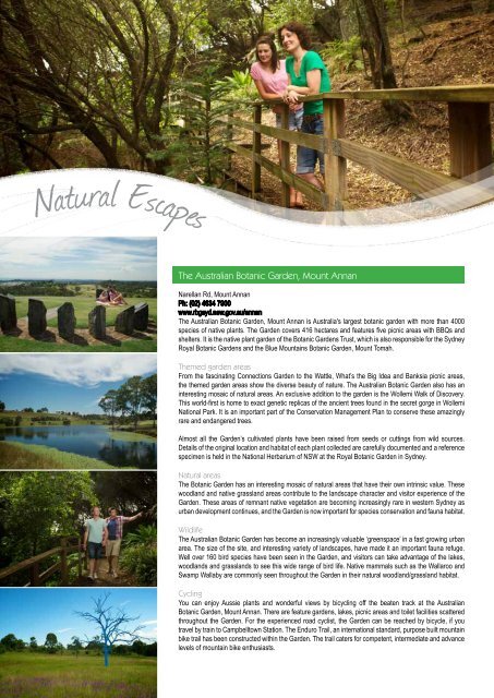
Natural Escapes<br />
<strong>The</strong> <strong>Australian</strong> <strong>Botanic</strong> <strong>Garden</strong>, <strong>Mount</strong> <strong>Annan</strong><br />
Narellan Rd, <strong>Mount</strong> <strong>Annan</strong><br />
Ph: (02) 4634 7900<br />
www.rbgsyd.nsw.gov.au/annan<br />
<strong>The</strong> <strong>Australian</strong> <strong>Botanic</strong> <strong>Garden</strong>, <strong>Mount</strong> <strong>Annan</strong> is Australia's largest botanic garden with more than 4000<br />
species of native plants. <strong>The</strong> <strong>Garden</strong> covers 416 hectares and features five picnic areas with BBQs and<br />
shelters. It is the native plant garden of the <strong>Botanic</strong> <strong>Garden</strong>s Trust, which is also responsible for the Sydney<br />
Royal <strong>Botanic</strong> <strong>Garden</strong>s and the Blue <strong>Mount</strong>ains <strong>Botanic</strong> <strong>Garden</strong>, <strong>Mount</strong> Tomah.<br />
<strong>The</strong>med garden areas<br />
From the fascinating Connections <strong>Garden</strong> to the Wattle, What’s the Big Idea and Banksia picnic areas,<br />
the themed garden areas show the diverse beauty of nature. <strong>The</strong> <strong>Australian</strong> <strong>Botanic</strong> <strong>Garden</strong> also has an<br />
interesting mosaic of natural areas. An exclusive addition to the garden is the Wollemi Walk of Discovery.<br />
This world-first is home to exact genetic replicas of the ancient trees found in the secret gorge in Wollemi<br />
National Park. It is an important part of the Conservation Management Plan to conserve these amazingly<br />
rare and endangered trees.<br />
Almost all the <strong>Garden</strong>’s cultivated plants have been raised from seeds or cuttings from wild sources.<br />
Details of the original location and habitat of each plant collected are carefully documented and a reference<br />
specimen is held in the National Herbarium of NSW at the Royal <strong>Botanic</strong> <strong>Garden</strong> in Sydney.<br />
Natural areas<br />
<strong>The</strong> <strong>Botanic</strong> <strong>Garden</strong> has an interesting mosaic of natural areas that have their own intrinsic value. <strong>The</strong>se<br />
woodland and native grassland areas contribute to the landscape character and visitor experience of the<br />
<strong>Garden</strong>. <strong>The</strong>se areas of remnant native vegetation are becoming increasingly rare in western Sydney as<br />
urban development continues, and the <strong>Garden</strong> is now important for species conservation and fauna habitat.<br />
Wildlife<br />
<strong>The</strong> <strong>Australian</strong> <strong>Botanic</strong> <strong>Garden</strong> has become an increasingly valuable ‘greenspace’ in a fast growing urban<br />
area. <strong>The</strong> size of the site, and interesting variety of landscapes, have made it an important fauna refuge.<br />
Well over 160 bird species have been seen in the <strong>Garden</strong>, and visitors can take advantage of the lakes,<br />
woodlands and grasslands to see this wide range of bird life. Native mammals such as the Wallaroo and<br />
Swamp Wallaby are commonly seen throughout the <strong>Garden</strong> in their natural woodland/grassland habitat.<br />
Cycling<br />
You can enjoy Aussie plants and wonderful views by bicycling off the beaten track at the <strong>Australian</strong><br />
<strong>Botanic</strong> <strong>Garden</strong>, <strong>Mount</strong> <strong>Annan</strong>. <strong>The</strong>re are feature gardens, lakes, picnic areas and toilet facilities scattered<br />
throughout the <strong>Garden</strong>. For the experienced road cyclist, the <strong>Garden</strong> can be reached by bicycle, if you<br />
travel by train to Campbelltown Station. <strong>The</strong> Enduro Trail, an international standard, purpose built mountain<br />
bike trail has been constructed within the <strong>Garden</strong>. <strong>The</strong> trail caters for competent, intermediate and advance<br />
levels of mountain bike enthusiasts.
Koshigaya Park<br />
Cnr <strong>Camden</strong> and Hurley Rds, Campbelltown<br />
Ph: (02) 4645 4000<br />
Koshigaya Park was opened in 1984 in<br />
celebration of Campbelltown's Sister City<br />
relationship with Koshigaya, Japan. Today it<br />
is a popular venue for outdoor activites and<br />
functions. Facilities available include sheltered<br />
picnic tables, BBQ facilities, toilet amenities and<br />
modern playground equipment.<br />
Macarthur Centre for Sustainable Living<br />
Macarthur Park<br />
<strong>Mount</strong> <strong>Annan</strong> Dr, <strong>Mount</strong> <strong>Annan</strong><br />
Ph: (02) 4647 9828<br />
www.mcsl.org.au<br />
<strong>The</strong> centre includes functioning displays of renewable solar energy production and use, waste water<br />
recycling, water and energy efficiency, waste avoidance and management. <strong>The</strong> centre demonstrates<br />
environmentally sound design and construction methods, utilising renewable and recycled building<br />
materials. Display space and regular events are onsite which enhance the sustainability of homes<br />
and gardens. For researchers, there are opportunities to investigate aspects of the use of renewable<br />
building materials or organic gardening methods.<br />
Menangle Rd, <strong>Camden</strong><br />
Ph: (02) 4654 7777<br />
<strong>The</strong> park was opened in 1906 and has a number of different areas including a heritage rose garden,<br />
wisteria walk, Cenotaph honouring World War I soldiers and a shelter built in 1913 in memory of Mrs<br />
Elizabeth Macarthur-Onslow. Mrs Elizabeth Macarthur-Onslow, a granddaughter of John Macarthur,<br />
gifted Macarthur Park to the people of <strong>Camden</strong> in 1905. <strong>The</strong> park is home to <strong>Camden</strong>'s War Memorial<br />
and the Faithfull-Anderson Fountain which once stood, where the roundabout is now, at the John and<br />
Argyle Streets intersection. In 1905, <strong>Camden</strong> was a rural village and the land for the park was at the<br />
perimeter of residential blocks. <strong>The</strong> forethought used in donating the park has ensured the people of<br />
<strong>Camden</strong> can still enjoy the rural atmosphere of the past that the park engenders.<br />
Pembroke Park<br />
Pembroke Rd, Minto<br />
Ph: (02) 4645 4000<br />
Pembroke Park has an area of approximately<br />
seven hectares and is one of the most popular<br />
parks in Campbelltown. <strong>The</strong> park is extremely<br />
popular with weekend family groups and has a<br />
range of facilities including BBQ and playground<br />
equipment.<br />
www.macarthur.com.au<br />
NATURAL ESCAPES<br />
29
NATURAL ESCAPES<br />
30<br />
Bushwalking<br />
Macarthur is bordered by scenic hills, nature reserves and the Georges and Nepean<br />
Rivers. If you enjoy a bushwalk or a relaxing picnic - there are plenty of places to<br />
escape to. <strong>The</strong> bushland in Macarthur was an important focal point for Indigenous life<br />
and culture in the southern Sydney region, offering both food and dreamtime links.<br />
Today, the area is a highly significant landscape feature of the Sydney region and<br />
environment. It is home to much biodiversity, including an active koala colony, and<br />
provides immense scenic value to the region.<br />
Dharawal National Park<br />
Victoria Rd, Wedderburn<br />
<strong>The</strong> Dharawal National Park, declared in 2012, has been managed by the National Parks and Wildlife<br />
Service since 1974. Waterfalls, extensive upland swamps, steep-sided sandstone gorges, swimming<br />
holes and rock shelters are just some of the many fascinating landscape features you can explore.<br />
‘Dharawal’ refers to the language group of the local Indigenous people who have continued their<br />
relationship with the area for more than 15,000 years. <strong>The</strong>ir long occupation of the area is evidenced<br />
by many Indigenous sites, making the reserve among the richest in Indigenous heritage in the Sydney<br />
region.<br />
Walking Trail - Jingga Walking Track, Wedderburn<br />
Jingga means 'nice and sweet' in reference to water, from the Dharawal language group.<br />
Accessed via Victoria Rd, Wedderburn<br />
Distance: 2.8km return<br />
Duration: 1 hour<br />
Grade: Hard, includes some steep hills<br />
Follow the Victoria Rd Fire Management Trail in an easterly direction for approximately 500m, then take<br />
the track on your right. Follow the Jingga Track and it will lead you to a spectacular waterhole along<br />
O'Hares Creek.<br />
Walking Trail - Madden Falls Walking Track, Darkes Forest<br />
Accessed via the Princes Hwy, then Darkes Forest Rd, Darkes Forest<br />
Distance: 2km return<br />
Time: 45 minutes<br />
Grade: Easy<br />
From the carpark, follow the Fire Management Trail to Maddens Creek, walk along the raised walking<br />
track until you reach the viewing platform at the falls. Note: No picnic or toilet facilities are located in the<br />
Dharawal National Park.<br />
www.macarthur.com.au<br />
www.macarthur.com.au
Macarthur Bushwalkers<br />
Ph: (02) 4628 2528<br />
www.bushwalking-cycling.com<br />
<strong>The</strong> Macarthur Bushwalkers are a local group.<br />
Activities include backpacking, hiking, trekking<br />
and bushwalking, both locally and further<br />
afield. Enjoy all levels from short day walks to<br />
overnight trips.<br />
William Howe Regional Park<br />
Mary Howe Pl, Narellan Vale<br />
This regional park supports natural vegetation<br />
within surrounding agricultural and residential<br />
areas. Expansive views of the surrounding<br />
areas are available from Turkeys Nest Dam.<br />
A walking track leads visitors to the lookout<br />
platform and picnic tables. Dogwalking (on<br />
leads) is permitted.<br />
<strong>Mount</strong>ain Devils Bushwalking<br />
Ph: (02) 9603 3559<br />
www.mountaindevils.org.au<br />
<strong>The</strong> <strong>Mount</strong>ain Devils Bushwalking and Social<br />
Club is dedicated to the enjoyment of the great<br />
<strong>Australian</strong> bush. Activities are run on weekends<br />
and include one day walks, overnight trips<br />
and social gatherings such as movie nights or<br />
dinners. Walks can vary in both distance and<br />
terrain and can cater for all levels of fitness.<br />
Razorback Lookout<br />
Remembrance Dr, Razorback<br />
Razorback has panoramic views of the district<br />
and to Sydney.<br />
National Parks Association<br />
Macarthur Branch<br />
http://branches.npansw.org.au/br-macarthur<br />
<strong>The</strong> NPA offers a variety of activities including<br />
an extensive bushwalking and camping<br />
program. <strong>The</strong> NPA is a non-profit community<br />
organisation founded in 1957, which seeks to<br />
to protect, connect and restore the integrity and<br />
diversity of natural systems in NSW (Australia)<br />
and beyond through national parks, marine<br />
sanctuaries and other means.<br />
<strong>The</strong> main activity of the Macarthur Branch<br />
is the conservation and protection of our<br />
natural habitat. In addition, it is involved in<br />
a comprehensive range of activities that<br />
are related to our appreciation of the bush<br />
and nature. <strong>The</strong>se include a lecture series,<br />
biodiversity surveys and through NPA NSW, an<br />
extensive bushwalking and camping program.<br />
www.macarthur.com.au<br />
NATURAL ESCAPES<br />
31
NATURAL ESCAPES<br />
32<br />
<strong>The</strong> Georges River<br />
Historical and Cultural Importance<br />
<strong>The</strong> Georges River was an important focal point for Aboriginal life and culture in the southern Sydney region, offering both food, transport and dreamtime links.<br />
Several major language groups existed alsong the river: Eora to the east, Dharag to the west, north and north-east, Dharawal to the south and Gandangarra in<br />
the far south-west. <strong>The</strong> early 1800s saw European settlers migrating to the areas along the Georges River. Much of the catchment was cleared for farmlands<br />
and housing, however the banks stayed relatively untamed due to their rugged slopes. Development within the catchment has flourished since WWII. Today,<br />
the Georges River and surrounds are a highly significant landscape feature of the Sydney region and the Campbelltown environment. It is home to much of the<br />
biodiversity that can be found in the region, including an active koala colony, and provides immense scenic value to the area. <strong>The</strong> corridor also offers a number<br />
of recreational opportunities for local residents. This brochure outlines some of these recreational opportunities and where they can be undertaken.<br />
Planning Your Trip<br />
When accessing bushland areas, care should always be taken. Please consider the<br />
following guidelines in planning your trip:<br />
• Let someone know where you are going and when you should return by. If you do<br />
not return by the designated time, this person can alert the appropriate authorities<br />
to get you assistance.<br />
• Dress suitably for the environment. When in bushland areas, you should dress<br />
suitably, such as enclosed shoes, dress for the weather (hot or cold) and wear<br />
appropriate sun protection (hat, sunglasses and sunscreen).<br />
• You should always take water with you, as you cannot guarantee that there will be<br />
suitable drinking water sources in bushland areas.<br />
• Please take your rubbish with you or place it in the bins provided.<br />
• <strong>The</strong> Georges River may not be suitable for swimming, particularly after heavy rain, as<br />
entry into the water may result in illness or infection during this period. People swimming<br />
do so at their own risk.<br />
• All visitors are to read and follow the site specific signage displayed at each<br />
reserve to keep yourself, other visitors and the environment safe.<br />
• If travelling by car, make sure that your vehicle is locked and that you do not leave<br />
any valuables in your car.<br />
• All fauna, flora and rock formations are protected.<br />
• Keep to the signposted management trails and walking tracks.<br />
• Wildfires can destroy lives and property, so be careful. Observe all fire bans.<br />
• Any camping must be in designated camping locations.<br />
www.macarthur.com.au<br />
www.macarthur.com.au<br />
BRADBURY<br />
LEUMEAH<br />
CAMPBELLTOWN<br />
RUSE<br />
THE WOOLWASH<br />
MINTO<br />
INGLEBURN<br />
KENTLYN<br />
GLENFIELD<br />
MINTO HEIGHTS<br />
INGLEBURN RESERVE<br />
FRERES CROSSING<br />
MACQUARIE<br />
FIELDS<br />
SIMMO’S BEACH<br />
KEITH LONGHURST RESERVE
Simmo’s Beach Reserve<br />
Fifth Ave, Macquarie Fields<br />
Distance: Various tracks ranging from 500m to 1.5km return walks<br />
Grade: <strong>The</strong> tracks range from easy (paved, mostly flat) through to hard (narrow,<br />
sloping, unsealed)<br />
Suitable for: Bushwalking and picnics (toilets, picnic tables and BBQ facilities available)<br />
Simmo’s Beach is located on the Georges River. Its easy access, picnic facilities and beach<br />
area make it a popular site for local residents. <strong>The</strong> reserve, which was officially opened in<br />
1986, is named after Simmonds, a past resident, who mined sand adjacent to the Georges<br />
River for a number of years. <strong>The</strong> features of the reserve such as extensive areas of bushland,<br />
proximity to the Georges River and connectivity with the Georges River Regional Open<br />
Space, means it provides a range of recreational opportunities. <strong>Council</strong> is currently in the<br />
process of upgrading existing tracks in the reserve that will provide a network of tracks for a<br />
range of difficulty levels when complete.<br />
Ingleburn Reserve<br />
Picnic Grove, Ingleburn<br />
Distance: 400m return walk takes visitors down to the weir<br />
Grade: Medium. Sandstone steps. Trail surface is loose and rocky in places<br />
Suitable for: Bushwalking and picnics (picnic tables and toilet facilities are located at the<br />
reserve)<br />
Ingleburn Reserve is a bushland reserve located in Ingleburn. Situated on the Georges<br />
River, the reserve contains the historic Ingleburn Weir, which was constructed in the late<br />
1930s to provide a swimming area for the local community. A study prepared for <strong>Council</strong><br />
in 2008 concluded that the weir has a high heritage significance due to its sandstone<br />
structure and form. Works were conducted in 2009 to enhance fish passage in the river<br />
system. <strong>The</strong> vegetation community at Ingleburn Reserve is classified as the endangered<br />
ecological community, Shale Sandstone Transition Forest. <strong>The</strong> reserve is home to a number<br />
of endangered plant species, as well as a range of native birds, some marsupials, other small<br />
mammals and reptiles.<br />
Keith Longhurst Reserve (<strong>The</strong> Basin)<br />
Georges River Rd, Kentlyn<br />
<strong>The</strong> Basin Walking Track<br />
Distance: 2km return walk<br />
Grade: Medium. <strong>The</strong> end of the track is quite steep and is only recommended for<br />
people of moderate fitness<br />
Suitable for: Bushwalking<br />
<strong>The</strong> Old Ford Road Walking Track<br />
Distance: 2.6km return walk<br />
Grade: Easy. An established, sloping track, suitable for a wide variety of fitness levels<br />
Suitable for: Bushwalking and mountain biking<br />
<strong>The</strong> Keith Longhurst Reserve is a 76 hectare bushland reserve with significant scenic and<br />
cultural values. <strong>The</strong> reserve, formally known as <strong>The</strong> Basin Reserve, includes a number of<br />
walks including <strong>The</strong> Basin Walking Track and the Old Ford Road Walking Track, which is a<br />
historic road built in the 1880s to cross the Georges River. <strong>The</strong> Dharawal people originally<br />
inhabited the area, and there are many sites of cultural significance. <strong>The</strong>re are no formal<br />
picnic facilities located at Keith Longhurst Reserve.<br />
Freres Crossing<br />
Georges River Rd, Kentlyn<br />
Distance: 2km return walk along an established firetrail<br />
Grade: Medium, includes hills. Trail surface is loose and rocky in places. Steep<br />
sections<br />
Suitable for: Bushwalking and experienced mountain bike riding<br />
Freres Crossing is a significant heritage site containing the remnants of an old wooden<br />
bridge that formed part of a connection between Campbelltown to Newcastle up to 1917.<br />
<strong>The</strong> crossing was named after George Pierre Frere, who owned a property at Eckersley.<br />
By 1913, all residents had been moved out of the area to make way for the military reserve.<br />
It is one of the most scenic sites along the Georges River in the Campbelltown area. Take<br />
a walk and enjoy the serene environment. Experienced bushwalkers can make their way<br />
along the river to Keith Longhurst Reserve (<strong>The</strong> Basin) and make this a circular day walk by<br />
leaving their vehicle on Georges River Road. <strong>The</strong>re are no formal picnic facilities located at<br />
Freres Crossing.<br />
INGLEBURN<br />
RESERVE<br />
www.macarthur.com.au<br />
www.macarthur.com.au<br />
GEORGES RIVER<br />
GEORGES RIVER<br />
WEIR<br />
THE BASIN<br />
GEORGES RIVER<br />
NATURAL ESCAPES<br />
33