Chapter 3 Designation of Zoning Districts, Zoning Map ... - City of Mesa
Chapter 3 Designation of Zoning Districts, Zoning Map ... - City of Mesa
Chapter 3 Designation of Zoning Districts, Zoning Map ... - City of Mesa

Create successful ePaper yourself
Turn your PDF publications into a flip-book with our unique Google optimized e-Paper software.
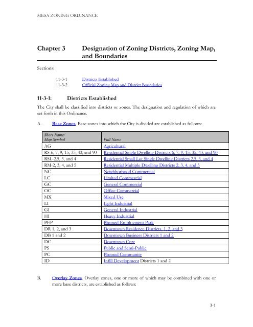
MESA ZONING ORDINANCE<br />
<strong>Chapter</strong> 3 <strong>Designation</strong> <strong>of</strong> <strong>Zoning</strong> <strong>Districts</strong>, <strong>Zoning</strong> <strong>Map</strong>,<br />
and Boundaries<br />
Sections:<br />
11-3-1 <strong>Districts</strong> Established<br />
11-3-2 Official <strong>Zoning</strong> <strong>Map</strong> and District Boundaries<br />
11-3-1: <strong>Districts</strong> Established<br />
The <strong>City</strong> shall be classified into districts or zones. The designation and regulation <strong>of</strong> which are<br />
set forth in this Ordinance.<br />
A. Base Zones. Base zones into which the <strong>City</strong> is divided are established as follows:<br />
Short Name/<br />
<strong>Map</strong> Symbol Full Name<br />
AG Agricultural<br />
RS-6, 7, 9, 15, 35, 43, and 90 Residential Single Dwelling <strong>Districts</strong> 6, 7, 9, 15, 35, 43, and 90<br />
RSL-2.5, 3, and 4 Residential Small Lot Single Dwelling <strong>Districts</strong> 2.5, 3, and 4<br />
RM-2, 3, 4, and 5 Residential Multiple Dwelling <strong>Districts</strong> 2, 3, 4, and 5<br />
NC Neighborhood Commercial<br />
LC Limited Commercial<br />
GC General Commercial<br />
OC Office Commercial<br />
MX Mixed Use<br />
LI Light Industrial<br />
GI General Industrial<br />
HI Heavy Industrial<br />
PEP Planned Employment Park<br />
DR 1, 2, and 3 Downtown Residence <strong>Districts</strong>, 1, 2, and 3<br />
DB 1 and 2 Downtown Business <strong>Districts</strong> 1 and 2<br />
DC Downtown Core<br />
PS Public and Semi-Public<br />
PC Planned Community<br />
ID Infill Development <strong>Districts</strong> 1 and 2<br />
B. Overlay Zones. Overlay zones, one or more <strong>of</strong> which may be combined with one or<br />
more base districts, are established as follows:<br />
3-1
MESA ZONING ORDINANCE <strong>Chapter</strong> 3: <strong>Designation</strong> <strong>of</strong> <strong>Zoning</strong> <strong>Districts</strong>, <strong>Zoning</strong> <strong>Map</strong>, and Boundaries<br />
Short Name/<br />
<strong>Map</strong> Symbol Full Name<br />
AF Airfield<br />
AS Age-Specific<br />
BIZ Bonus Intensity Zone<br />
PAD Planned Area Development<br />
HD Historic District<br />
HL Historic Landmark<br />
DE Downtown Event<br />
C. Community Character Designators. Recognizing that not all areas <strong>of</strong> the <strong>City</strong> are the<br />
same, two community character designators have been established to enhance some<br />
multi-residence, commercial and mixed-use districts. These designators are combined<br />
with the base district abbreviations in order to establish area-specific development<br />
standards according to the intended development character.<br />
1. Urban (-U). This designation is intended for areas with an urban character,<br />
where buildings are built close to the street and sidewalk to provide a close<br />
relationship between pedestrians and shops. Site and building design standards<br />
will reinforce this character and require treatments that provide an interesting,<br />
safe and comfortable pedestrian environment. This designation may apply to<br />
some areas where a few auto-oriented uses exist, but where creating, restoring,<br />
or maintaining a pedestrian character is called for in the General Plan, a Sub-<br />
Area Plan or other <strong>City</strong> policy.<br />
2. Auto-Oriented (-A). This designation is intended for areas that provide for easy<br />
automobile access. Examples include Large Format Retail buildings that may be<br />
located at the back or side <strong>of</strong> a site with parking in front. Standards are intended<br />
to mitigate the impact <strong>of</strong> the parking lots and buffer adjacent residential areas.<br />
3. Associated <strong>Districts</strong>. The districts that may utilize the character designators<br />
are as follows:<br />
Short Name/<strong>Map</strong> Symbol Full Name Associated <strong>Zoning</strong> <strong>Districts</strong><br />
U Urban RM - Residential Multiple Dwelling<br />
NC - Neighborhood Commercial<br />
LC - Limited Commercial<br />
OC - Office Commercial<br />
MX - Mixed Use<br />
A Auto LC - Limited Commercial<br />
GC - General Commercial<br />
OC - Office Commercial<br />
Return to Page 1<br />
3-2
MESA ZONING ORDINANCE <strong>Chapter</strong> 3: <strong>Designation</strong> <strong>of</strong> <strong>Zoning</strong> <strong>Districts</strong>, <strong>Zoning</strong> <strong>Map</strong>, and Boundaries<br />
D. References to Classes <strong>of</strong> Base <strong>Districts</strong>. Throughout the Ordinance, base zoning<br />
districts may be referred to as a group or in a singular manner through the use <strong>of</strong> the<br />
associated words listed as “Synonymous Terms” in the table below, based on the context<br />
<strong>of</strong> how the phrase is used.<br />
Base <strong>Zoning</strong> District Groups<br />
Residential Groups<br />
RS, Residential Single-Dwelling;<br />
RM, Residential Multiple-Dwelling;<br />
RSL, Residential Small Lot Single-Dwelling<br />
DR, Downtown Residential<br />
Commercial Groups<br />
NC, Neighborhood Commercial;<br />
LC, Limited Commercial;<br />
GC, General Commercial;<br />
OC, Office Commercial;<br />
MX, Mixed Use<br />
DB, Downtown Business<br />
DC, Downtown Core<br />
Mixed Use Groups<br />
Industrial or Employment Groups<br />
LI, Light Industrial;<br />
GI, General Industrial;<br />
HI, Heavy Industrial; and<br />
PEP, Planned Employment Park<br />
DR, Downtown Residential<br />
DB, Downtown Business<br />
DC, Downtown Core<br />
Downtown Groups<br />
Associated Synonymous<br />
Terms<br />
R-zone;<br />
R-district;<br />
Residential Zone; or<br />
Residential District<br />
C-zone;<br />
C-district;<br />
Commercial Zone; or<br />
Commercial District<br />
Mixed-district;<br />
Mixed-zone<br />
I-zone;<br />
I-district;<br />
Industrial Zone;<br />
Industrial District;<br />
Employment District; or<br />
Employment Zone;<br />
Downtown District<br />
Downtown Zone<br />
11-3-2: Official <strong>Zoning</strong> <strong>Map</strong> and District Boundaries<br />
The boundaries <strong>of</strong> the zones established by this Ordinance are not included in this Ordinance<br />
but are shown on the Official <strong>Zoning</strong> <strong>Map</strong> maintained by the <strong>City</strong>. The Official <strong>Zoning</strong> <strong>Map</strong>,<br />
together with all legends, symbols, notations, references, zoning district boundaries, map<br />
symbols, and other information on the maps, has been adopted by the <strong>City</strong> Council and are<br />
Return to Page 1<br />
3-3
MESA ZONING ORDINANCE <strong>Chapter</strong> 3: <strong>Designation</strong> <strong>of</strong> <strong>Zoning</strong> <strong>Districts</strong>, <strong>Zoning</strong> <strong>Map</strong>, and Boundaries<br />
hereby incorporated into this Ordinance by reference, together with any amendments previously<br />
or hereafter adopted, as though they were fully included here.<br />
A. Uncertainty <strong>of</strong> Boundaries. Where uncertainty exists as to the boundaries <strong>of</strong> any<br />
district shown on the Official <strong>Zoning</strong> <strong>Map</strong>, the following rules shall apply:<br />
1. Boundaries indicated as approximately following property or land parcel lines,<br />
street or alley rights-<strong>of</strong>-way, city limits, or extraterritorial boundary lines shall be<br />
construed as following such lines, limits or boundaries.<br />
2. In the case <strong>of</strong> unsubdivided property or where a district boundary divides a lot<br />
and no dimensions are indicated, the following shall apply.<br />
a. Lots Greater than One Acre. The location <strong>of</strong> such boundary shall be<br />
determined by the use <strong>of</strong> the scale appearing on the Official <strong>Zoning</strong><br />
<strong>Map</strong>.<br />
b. Lots Less than One Acre. The lot shall be deemed to be included within<br />
the zone which is the more restrictive.<br />
3. In the case <strong>of</strong> any remaining uncertainty, the <strong>Zoning</strong> Administrator shall<br />
determine the location <strong>of</strong> boundaries.<br />
4. Where any public street or alley is <strong>of</strong>ficially vacated or abandoned, the land<br />
underlying the street or alley will be added to abutting lots as required by state<br />
law. The regulations that applied to the abutting parcel or parcels before the<br />
vacation or abandonment shall apply to the entire new larger parcel or parcels<br />
that result from such vacation or abandonment.<br />
5. Where any private right-<strong>of</strong>-way or easement <strong>of</strong> any railroad, railway,<br />
transportation or public utility company is vacated or abandoned the land<br />
underlying the right <strong>of</strong> way or easement shall be added to abutting lots as<br />
required by state law. If the abandoned or vacated property is unclassified, the<br />
property shall be automatically classified as being in the same zone <strong>of</strong> the<br />
abutting land to which it is added.<br />
B. Conditions. Conditions imposed by special ordinance in conjunction with amendments<br />
to the <strong>Zoning</strong> <strong>Map</strong> are referenced by separate files maintained in the Planning Division<br />
and are made a part <strong>of</strong> the <strong>Zoning</strong> <strong>Map</strong>.<br />
Return to Page 1<br />
3-4