Australia's last great whale haven.pdf - Ningaloo Atlas
Australia's last great whale haven.pdf - Ningaloo Atlas
Australia's last great whale haven.pdf - Ningaloo Atlas
- TAGS
- whale
- ningaloo
- atlas
- www.ifaw.org

You also want an ePaper? Increase the reach of your titles
YUMPU automatically turns print PDFs into web optimized ePapers that Google loves.
Australia’s Last Great Whale Haven Threats<br />
26<br />
Shipping<br />
A number of busy ports operate along the NW<br />
coastline, and shipping traffic is increasing, both<br />
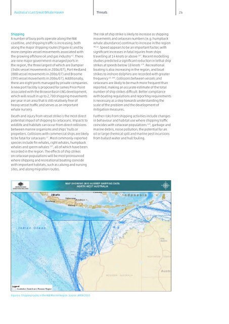
along the major shipping routes (Figure 6) and by<br />
more complex vessel movements associated with<br />
the growing offshore oil and gas industry 62 . There<br />
are nine major government-managed ports in<br />
the region, the three largest of which are Dampier<br />
(3404 vessel movements in 2006/07), Port Hedland<br />
(888 vessel movements in 2006/07) and Broome<br />
(393 vessel movements in 2006/07). Additionally,<br />
there are eight ports managed by private companies.<br />
A new port facility is proposed for James Price Point<br />
associated with the Browse Basin LNG development,<br />
which will result in up to 2,700 shipping movements<br />
per year in an area that is still relatively free of<br />
heavy vessel traffic and serves as an important<br />
<strong>whale</strong> nursery.<br />
Death and injury from vessel strike is the most direct<br />
potential impact of shipping to cetaceans. Impacts to<br />
wildlife and habitats can occur from direct collisions<br />
between marine organisms and ships’ hulls or<br />
propellers. Collisions with commercial ships are likely<br />
to be fatal for cetaceans 17 . Most commonly-reported<br />
species include fin <strong>whale</strong>s, right <strong>whale</strong>s, humpback<br />
<strong>whale</strong>s and sperm <strong>whale</strong>s 107 , all of which have been<br />
recorded in the region. The effects of ship strikes<br />
on cetacean populations will be most pronounced<br />
where shipping and recreational boating coincide<br />
with important habitats, such as calving and nursing<br />
sites, and along migration routes.<br />
Figure 6. Shipping routes in the NW Marine Region. Source: AMSA 2010<br />
The risk of ship strike is likely to increase as shipping<br />
movements and cetacean numbers (e.g. humpback<br />
<strong>whale</strong> abundance) continue to increase in the region<br />
38, 62 . Speed appears to be an important factor, with<br />
significant increases in fatal injuries from ships<br />
travelling at 14 knots or above 107 . Recent modelling<br />
studies predicted a significant reduction in lethal ship<br />
strikes at speeds below 10 knots 179 . Recreational<br />
boating is also increasing in the region, and boat<br />
strikes to inshore dolphins are recorded with <strong>great</strong>er<br />
frequency 62, 180 . Collisions between vessels and<br />
cetaceans are likely to be much more frequent than<br />
reported, making an accurate estimate of the total<br />
number of ship strikes difficult. Better compliance<br />
with boating regulations and reporting requirements<br />
is necessary as a step towards understanding the<br />
scale of the problem and the development of<br />
mitigation measures.<br />
Further risks from shipping activities include changes<br />
in behaviour and habitat use where shipping traffic<br />
coincides with cetacean populations 123 , garbage and<br />
marine debris, noise pollution, the potential for an<br />
oil or large chemical spill and marine pest incursions<br />
from bal<strong>last</strong> water and hull fouling.