plan estratégico para el drenaje pluvial del sur de ... - sinat - Semarnat
plan estratégico para el drenaje pluvial del sur de ... - sinat - Semarnat
plan estratégico para el drenaje pluvial del sur de ... - sinat - Semarnat

You also want an ePaper? Increase the reach of your titles
YUMPU automatically turns print PDFs into web optimized ePapers that Google loves.
INSTITUTO METROPOLITANO DE PLANEACIÓN DEL SUR DE TAMAULIPAS<br />
I. DATOS GENERALES DEL PROYECTO, DEL PROMOVENTE Y DEL<br />
RESPONSABLE DEL ESTUDIO DE IMPACTO AMBIENTAL<br />
I.1 Proyecto<br />
El anexo 1 contiene un croquis con las características <strong>de</strong> ubicación d<strong>el</strong> proyecto, las<br />
localida<strong>de</strong>s próximas, rasgos fisiográficos e hidrológicos sobresalientes y próximos,<br />
vías <strong>de</strong> comunicación y otras que permitirán su fácil localización.<br />
I.1.1 Nombre d<strong>el</strong> proyecto<br />
PLAN ESTRATÉGICO PARA EL DRENAJE PLUVIAL DEL SUR DE<br />
TAMAULIPAS<br />
Obras <strong>de</strong> <strong>drenaje</strong> <strong>pluvial</strong> en la Divisoria Tampico-Altamira, en Altamira, Tam.<br />
Obras <strong>para</strong> <strong>el</strong> <strong>drenaje</strong> <strong>pluvial</strong> en la calle Aldama en Cd. Ma<strong>de</strong>ro y Tampico,<br />
Tam.<br />
Ampliación d<strong>el</strong> dren <strong>de</strong> la Col. Mor<strong>el</strong>os y construcción <strong>de</strong> drenes en la Zona<br />
Centro, calle Esperanza, Benito Juárez, Colón, y Perimetral Fid<strong>el</strong> V<strong>el</strong>ázquez,<br />
en Tampico, Tam.<br />
I.1.2 Ubicación d<strong>el</strong> proyecto<br />
Las obras se ubican en la zona <strong>sur</strong> d<strong>el</strong> estado <strong>de</strong> Tamaulipas, en los municipios <strong>de</strong><br />
Altamira, Cd. Ma<strong>de</strong>ro y Tampico.<br />
I.1.3 Tiempo <strong>de</strong> vida útil d<strong>el</strong> proyecto (acotarlo en años o meses)<br />
Consi<strong>de</strong>rando que la obra estará sujeta a un programa <strong>de</strong> mantenimiento continuo se<br />
estima su vida útil permanente.<br />
MANIFESTACIÓN DE IMPACTO AMBIENTAL MODALIDAD PARTICULAR SECTOR HIDRÁULICO<br />
PROYECTO. PLAN ESTRATÉGICO PARA EL DRENAJE PLUVIAL DEL SUR DE TAMAULIPAS:<br />
OBRAS DE DRENAJE PLUVIAL EN LA DIVISORIA TAMPICO-ALTAMIRA, EN ALTAMIRA, TAM.<br />
OBRAS PARA EL DRENAJE PLUVIAL EN LA CALLE ALDAMA EN CD MADERO Y TAMPICO, TAM.<br />
AMPLIACIÓN DEL DREN DE LA COL. MORELOS Y CONSTRUCCIÓN DE DRENES EN LA ZONA CENTRO, CALLE<br />
ESPERANZA, BENITO JUÁREZ, COLÓN, Y PERIMETRAL FIDEL VELÁZQUEZ, EN TAMPICO, TAM.<br />
CAPÍTULO I | Pág. 1
I.1.4 Presentación <strong>de</strong> la documentación legal<br />
MANIFESTACIÓN DE IMPACTO AMBIENTAL MODALIDAD PARTICULAR SECTOR HIDRÁULICO<br />
PROYECTO. PLAN ESTRATÉGICO PARA EL DRENAJE PLUVIAL DEL SUR DE TAMAULIPAS:<br />
OBRAS DE DRENAJE PLUVIAL EN LA DIVISORIA TAMPICO-ALTAMIRA, EN ALTAMIRA, TAM.<br />
OBRAS PARA EL DRENAJE PLUVIAL EN LA CALLE ALDAMA EN CD MADERO Y TAMPICO, TAM.<br />
AMPLIACIÓN DEL DREN DE LA COL. MORELOS Y CONSTRUCCIÓN DE DRENES EN LA ZONA CENTRO, CALLE<br />
ESPERANZA, BENITO JUÁREZ, COLÓN, Y PERIMETRAL FIDEL VELÁZQUEZ, EN TAMPICO, TAM.<br />
INSTITUTO METROPOLITANO DE PLANEACIÓN DEL SUR DE TAMAULIPAS<br />
De acuerdo con la LEY DE BIENES DEL ESTADO Y MUNICIPIOS DE TAMAULIPAS<br />
(LBEMT) <strong>el</strong> municipio está investido <strong>de</strong> personalidad y capacidad jurídica <strong>para</strong><br />
adquirir y poseer todo tipo <strong>de</strong> bienes muebles e inmuebles <strong>para</strong> <strong>el</strong> <strong>de</strong>sarrollo y<br />
cumplimiento <strong>de</strong> sus funciones constitucionales, así como <strong>para</strong> la prestación <strong>de</strong><br />
servicios públicos que les correspondan.<br />
Los bienes d<strong>el</strong> municipio pue<strong>de</strong>n ser <strong>de</strong> dominio público o privado, clasificándose los<br />
primeros en bienes <strong>de</strong> uso común y aqu<strong>el</strong>los <strong>de</strong>stinados a un servicio público.<br />
Se consi<strong>de</strong>ran como bienes <strong>de</strong> uso común aqu<strong>el</strong>los que pue<strong>de</strong>n ser aprovechados<br />
por los habitantes d<strong>el</strong> municipio sin más limitaciones y restricciones que las<br />
establecidas por la LBEMT; se encuentran entre otros, las calles y avenidas.<br />
I.2 Promovente<br />
I.2.1 Nombre o razón social Secretaría <strong>de</strong> Obras Públicas y Desarrollo<br />
I.2.2 Registro Fe<strong>de</strong>ral <strong>de</strong><br />
Causantes (RFC)<br />
I.2.3 Nombre y cargo d<strong>el</strong><br />
representante legal<br />
Urbano (SOPDU)<br />
SOPDUE OBP850101<br />
Secretaría <strong>de</strong> Finanzas d<strong>el</strong> Gobierno d<strong>el</strong><br />
Estado <strong>de</strong> Tamaulipas SFG210216AJ9<br />
Ing. Alberto Berlanga Bolado<br />
Secretario <strong>de</strong> la SOPDU<br />
I.2.4 Dirección d<strong>el</strong> promovente o <strong>de</strong> su representante legal<br />
I.2.4.1 Calle y número y/o rasgo<br />
geográfico <strong>de</strong> referencia<br />
I.2.4.2 Colonia, barrio No aplica<br />
Libramiento Naciones Unidas Carretera a<br />
Soto la Marina Km 5.6<br />
CAPÍTULO I | Pág. 2
I.2.4.3 Código postal 87130<br />
I.2.4.4 Entidad fe<strong>de</strong>rativa Tamaulipas<br />
I.2.4.5 Municipio o d<strong>el</strong>egación Cd. Victoria<br />
I.2.4.6 T<strong>el</strong>éfono(s) (52-834) 318-3400<br />
I.2.4.7 Fax (52-834) 318-3400<br />
MANIFESTACIÓN DE IMPACTO AMBIENTAL MODALIDAD PARTICULAR SECTOR HIDRÁULICO<br />
PROYECTO. PLAN ESTRATÉGICO PARA EL DRENAJE PLUVIAL DEL SUR DE TAMAULIPAS:<br />
OBRAS DE DRENAJE PLUVIAL EN LA DIVISORIA TAMPICO-ALTAMIRA, EN ALTAMIRA, TAM.<br />
OBRAS PARA EL DRENAJE PLUVIAL EN LA CALLE ALDAMA EN CD MADERO Y TAMPICO, TAM.<br />
AMPLIACIÓN DEL DREN DE LA COL. MORELOS Y CONSTRUCCIÓN DE DRENES EN LA ZONA CENTRO, CALLE<br />
ESPERANZA, BENITO JUÁREZ, COLÓN, Y PERIMETRAL FIDEL VELÁZQUEZ, EN TAMPICO, TAM.<br />
INSTITUTO METROPOLITANO DE PLANEACIÓN DEL SUR DE TAMAULIPAS<br />
I.2.4.8 Correo <strong>el</strong>ectrónico alberto.berlanga@tamaulipas.gob.mx<br />
I.3 Responsable <strong>de</strong> la <strong>el</strong>aboración d<strong>el</strong> estudio <strong>de</strong> impacto ambiental<br />
I.3.1 Nombre o razón social Ing. Gerardo R. Barrios Núñez <strong>de</strong> Cáceres<br />
I.3.2 Registro Fe<strong>de</strong>ral <strong>de</strong><br />
Contribuyentes o CURP<br />
I.3.3 Nombre d<strong>el</strong> responsable<br />
técnico d<strong>el</strong> estudio<br />
BANG-620111 2G4<br />
I.3.4 Dirección d<strong>el</strong> responsable técnico d<strong>el</strong> estudio<br />
I.3.4.1 Calle y número y/o rasgo<br />
geográfico <strong>de</strong> referencia<br />
Ing. Gerardo R. Barrios Núñez <strong>de</strong> Cáceres<br />
Calle Tampico 105-2<br />
I.3.4.2 Colonia, barrio Lauro Aguirre<br />
I.3.4.3 Código postal 89140<br />
I.3.4.4 Entidad fe<strong>de</strong>rativa Tamaulipas<br />
I.3.4.5 Municipio o d<strong>el</strong>egación Tampico<br />
I.3.4.6 T<strong>el</strong>éfono(s) (833) 217·3926, 217·3956<br />
I.3.4.7 Fax (833) 217·3926<br />
I.3.4.8 Correo <strong>el</strong>ectrónico gerardobarrios@prodigy.net.mx<br />
CAPÍTULO I | Pág. 3
INSTITUTO METROPOLITANO DE PLANEACIÓN DEL SUR DE TAMAULIPAS<br />
LOS ABAJO FIRMANTES DE ACUERDO CON EL ARTÍCULO 35 BIS 1 DE LA LEY GENERAL DEL<br />
EQUILIBRIO ECOLÓGICO Y PROTECCIÓN AL AMBIENTE BAJO PROTESTA DE DECIR VERDAD,<br />
MANIFIESTAN QUE EN LA INFORMACIÓN CONTENIDA EN LA PRESENTE<br />
MANIFESTACIÓN DE IMPACTO AMBIENTAL MODALIDAD PARTICULAR<br />
SECTOR HIDRÁULICO DE:<br />
OBRAS DE DRENAJE PLUVIAL EN LA DIVISORIA TAMPICO-ALTAMIRA, EN<br />
ALTAMIRA, TAM.<br />
OBRAS PARA EL DRENAJE PLUVIAL EN LA CALLE ALDAMA EN CD. MADERO Y<br />
TAMPICO, TAM.<br />
AMPLIACIÓN DEL DREN DE LA COL. MORELOS Y CONSTRUCCIÓN DE DRENES<br />
EN LA ZONA CENTRO, CALLE ESPERANZA, BENITO JUÁREZ, COLÓN, Y<br />
PERIMETRAL FIDEL VELÁZQUEZ, EN TAMPICO, TAM.<br />
QUE PROMUEVE:<br />
EL GOBIERNO DEL ESTADO DE TAMAULIPAS A TRAVÉS DE LA SECRETARIA DE OBRAS<br />
PÚBLICAS Y DESARROLLO URBANO (SOPDU)<br />
SE INCORPORAN LAS MEJORES TÉCNICAS Y METODOLOGÍAS EXISTENTES, ASÍ COMO LA<br />
INFORMACIÓN Y MEDIDAS DE PREVENCIÓN Y MITIGACIÓN MÁS EFECTIVAS DE ACUERDO CON<br />
LO MANIFESTADO EN EL PROYECTO EJECUTIVO QUE DESARROLLÓ EL PROMOVENTE DE LA<br />
OBRA.<br />
MANIFESTACIÓN DE IMPACTO AMBIENTAL MODALIDAD PARTICULAR SECTOR HIDRÁULICO<br />
PROYECTO. PLAN ESTRATÉGICO PARA EL DRENAJE PLUVIAL DEL SUR DE TAMAULIPAS:<br />
OBRAS DE DRENAJE PLUVIAL EN LA DIVISORIA TAMPICO-ALTAMIRA, EN ALTAMIRA, TAM.<br />
OBRAS PARA EL DRENAJE PLUVIAL EN LA CALLE ALDAMA EN CD MADERO Y TAMPICO, TAM.<br />
AMPLIACIÓN DEL DREN DE LA COL. MORELOS Y CONSTRUCCIÓN DE DRENES EN LA ZONA CENTRO, CALLE<br />
ESPERANZA, BENITO JUÁREZ, COLÓN, Y PERIMETRAL FIDEL VELÁZQUEZ, EN TAMPICO, TAM.<br />
CAPÍTULO I | Pág. 4
Responsable d<strong>el</strong> proyecto Participante<br />
Nombre: M.E. Gerardo Barrios Núñez <strong>de</strong> Cáceres Nombre: Biól. Herman Worbis Torres<br />
CÉD. PROF. NÚM.: 1018775 CÉD. PROF. NÚM.: 1100851<br />
Firma:<br />
Firma:<br />
Participante Participante<br />
MANIFESTACIÓN DE IMPACTO AMBIENTAL MODALIDAD PARTICULAR SECTOR HIDRÁULICO<br />
PROYECTO. PLAN ESTRATÉGICO PARA EL DRENAJE PLUVIAL DEL SUR DE TAMAULIPAS:<br />
OBRAS DE DRENAJE PLUVIAL EN LA DIVISORIA TAMPICO-ALTAMIRA, EN ALTAMIRA, TAM.<br />
OBRAS PARA EL DRENAJE PLUVIAL EN LA CALLE ALDAMA EN CD MADERO Y TAMPICO, TAM.<br />
AMPLIACIÓN DEL DREN DE LA COL. MORELOS Y CONSTRUCCIÓN DE DRENES EN LA ZONA CENTRO, CALLE<br />
ESPERANZA, BENITO JUÁREZ, COLÓN, Y PERIMETRAL FIDEL VELÁZQUEZ, EN TAMPICO, TAM.<br />
INSTITUTO METROPOLITANO DE PLANEACIÓN DEL SUR DE TAMAULIPAS<br />
Nombre: Biól. Victoria E. <strong>de</strong> Los Reyes Pintos Nombre: Biól. Roberto Rodríguez Maldonado<br />
CÉD. PROF. NÚM.: 1205867 CÉD. PROF. NÚM.: 806985<br />
Firma:<br />
Firma:<br />
Participante Participante<br />
Nombre: Ing. Claudia Oneyda Argü<strong>el</strong>les Espinosa Nombre: Biól. Brenda Leticia Reyes Hernán<strong>de</strong>z<br />
CÉD. PROF. NÚM.: PASANTE CÉD. PROF. NÚM.: 2271776<br />
Firma:<br />
Firma:<br />
Participante Participante<br />
Nombre: Ing. Marco Alfredo D<strong>el</strong>gado Reyes Nombre: Biól. Cynthia Karina Luévano Vargas<br />
CÉD. PROF. NÚM.: 5256169 CÉD. PROF. NÚM.: PASANTE<br />
Firma:<br />
Firma:<br />
CAPÍTULO I | Pág. 5
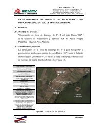
II. DESCRIPCIÓN DEL PROYECTO<br />
II.1 Información general d<strong>el</strong> proyecto<br />
MANIFESTACIÓN DE IMPACTO AMBIENTAL MODALIDAD PARTICULAR SECTOR HIDRÁULICO<br />
PROYECTO. PLAN ESTRATÉGICO PARA EL DRENAJE PLUVIAL DEL SUR DE TAMAULIPAS:<br />
OBRAS DE DRENAJE PLUVIAL EN LA DIVISORIA TAMPICO-ALTAMIRA, EN ALTAMIRA, TAM.<br />
OBRAS PARA EL DRENAJE PLUVIAL EN LA CALLE ALDAMA EN CD MADERO Y TAMPICO, TAM.<br />
AMPLIACIÓN DEL DREN DE LA COL. MORELOS Y CONSTRUCCIÓN DE DRENES EN LA ZONA CENTRO, CALLE<br />
ESPERANZA, BENITO JUÁREZ, COLÓN, Y PERIMETRAL FIDEL VELÁZQUEZ, EN TAMPICO, TAM.<br />
INSTITUTO METROPOLITANO DE PLANEACIÓN DEL SUR DE TAMAULIPAS<br />
El PLAN ESTRATÉGICO PARA EL DRENAJE PLUVIAL DEL SUR DE<br />
TAMAULIPAS requiere <strong>de</strong> la integración <strong>de</strong> proyectos específicos que se<br />
<strong>de</strong>sarrollarán en distintos puntos <strong>de</strong> la zona y confluyen en <strong>el</strong> mismo propósito u<br />
objetivo: ampliar, construir y mejorar <strong>el</strong> <strong>drenaje</strong> <strong>pluvial</strong> <strong>de</strong> la zona conurbada <strong>de</strong><br />
Tampico, Ma<strong>de</strong>ro y Altamira <strong>para</strong> disminuir los daños a la población por los<br />
escurrimientos <strong>pluvial</strong>es que se presentan.<br />
De acuerdo a la jerarquización <strong>de</strong> proyectos que representaban mayores conflictos<br />
en cuanto a inundaciones, se consi<strong>de</strong>ro <strong>de</strong>ntro <strong>de</strong> los primeros propósitos a realizar<br />
por la SOPDU las OBRAS DE DRENAJE PLUVIAL EN LA DIVISORIA Tampico-<br />
Altamira, en Altamira, las <strong>plan</strong>eadas <strong>para</strong> <strong>el</strong> DRENAJE PLUVIAL EN LA CALLE<br />
ALDAMA en Cd. Ma<strong>de</strong>ro y Tampico y la AMPLIACIÓN DEL DREN DE LA COL.<br />
MORELOS Y CONSTRUCCIÓN DE DRENES EN LA ZONA CENTRO, calle<br />
Esperanza, Benito Juárez, Colón y Perimetral Fid<strong>el</strong> V<strong>el</strong>ázquez, en Tampico,<br />
Tamaulipas.<br />
II.1.1 Naturaleza d<strong>el</strong> proyecto<br />
Un sistema <strong>de</strong> <strong>drenaje</strong> <strong>pluvial</strong> está dirigido al logro <strong>de</strong> objetivos hacia los cuales se<br />
encauzan las acciones a llevar a cabo. En <strong>el</strong> caso d<strong>el</strong> presente proyecto, los<br />
objetivos preten<strong>de</strong>n disminuir al máximo los daños que las aguas <strong>pluvial</strong>es pue<strong>de</strong>n<br />
ocasionar a la ciudadanía y a la infraestructura d<strong>el</strong> entorno urbano; asimismo<br />
garantizar <strong>el</strong> normal <strong>de</strong>senvolvimiento <strong>de</strong> la vida diaria durante la ocurrencia <strong>de</strong> tales<br />
precipitaciones.<br />
CAPÍTULO II | Pág. 1
INSTITUTO METROPOLITANO DE PLANEACIÓN DEL SUR DE TAMAULIPAS<br />
Con r<strong>el</strong>ación a lo señalado, tenemos que las lluvias que se presentan en la zona<br />
don<strong>de</strong> se construiría <strong>el</strong> <strong>drenaje</strong> <strong>pluvial</strong> en la Divisoria Tampico - Altamira,<br />
provocan inundaciones que <strong>de</strong> forma directa o indirecta afectan a los resi<strong>de</strong>ntes y<br />
transeúntes, poniendo no solo en riesgo los bienes, sino la integridad física <strong>de</strong> esta<br />
población.<br />
Es objetivo <strong>de</strong> esta obra, canalizar a<strong>de</strong>cuadamente los escurrimientos con <strong>el</strong> fin <strong>de</strong><br />
disminuir los daños que <strong>el</strong> agua pueda llegar a producir. Las acciones se <strong>de</strong>sarrollan<br />
principalmente, en la colonia Tampico-Altamira, ubicada en Altamira, en los límites <strong>de</strong><br />
éste con <strong>el</strong> municipio <strong>de</strong> Tampico. Sin embargo, <strong>el</strong> beneficio será <strong>de</strong> igual manera<br />
<strong>para</strong> la colonia Niños Héroes en Tampico, en los límites con <strong>el</strong> municipio <strong>de</strong> Altamira,<br />
cuya superficie forma parte <strong>de</strong> las cuencas que alimentan <strong>el</strong> canal <strong>de</strong> proyecto.<br />
En <strong>el</strong> caso <strong>de</strong> las obras <strong>para</strong> <strong>el</strong> <strong>drenaje</strong> <strong>pluvial</strong> en la calle Aldama en Cd. Ma<strong>de</strong>ro y<br />
Tampico, las fuertes y atípicas precipitaciones ocurridas en <strong>el</strong> área, han ocasionado<br />
daños en la infraestructura urbana; sobre todo al patrimonio <strong>de</strong> los habitantes<br />
asentados en las partes bajas, como <strong>el</strong> caso <strong>de</strong> la calle Aldama y su área aledaña.<br />
Finalmente dado <strong>el</strong> <strong>de</strong>sarrollo <strong>de</strong> la zona conurbada <strong>de</strong> la ciudad <strong>de</strong> Tampico y la<br />
importancia comercial d<strong>el</strong> área alre<strong>de</strong>dor <strong>de</strong> la zona conocida como <strong>de</strong>scarga<br />
hacia <strong>el</strong> río Pánuco, han evi<strong>de</strong>nciado la necesidad <strong>de</strong> la ampliación d<strong>el</strong> dren <strong>de</strong><br />
la Col. Mor<strong>el</strong>os.<br />
En estos momentos en la colonia Mor<strong>el</strong>os se <strong>de</strong>scarga <strong>de</strong> forma directa y<br />
superficial hacia los canales <strong>de</strong> <strong>de</strong>sfogue <strong>pluvial</strong> que son perimetrales hacia los<br />
bordos que limitan la colonia, presentándose una serie <strong>de</strong> insuficiencias hidráulicas<br />
<strong>de</strong> conducción <strong>de</strong> los escurrimientos <strong>de</strong> la cuenca urbana que inci<strong>de</strong>n en estos<br />
sitios.<br />
MANIFESTACIÓN DE IMPACTO AMBIENTAL MODALIDAD PARTICULAR SECTOR HIDRÁULICO<br />
PROYECTO. PLAN ESTRATÉGICO PARA EL DRENAJE PLUVIAL DEL SUR DE TAMAULIPAS:<br />
OBRAS DE DRENAJE PLUVIAL EN LA DIVISORIA TAMPICO-ALTAMIRA, EN ALTAMIRA, TAM.<br />
OBRAS PARA EL DRENAJE PLUVIAL EN LA CALLE ALDAMA EN CD MADERO Y TAMPICO, TAM.<br />
AMPLIACIÓN DEL DREN DE LA COL. MORELOS Y CONSTRUCCIÓN DE DRENES EN LA ZONA CENTRO, CALLE<br />
ESPERANZA, BENITO JUÁREZ, COLÓN, Y PERIMETRAL FIDEL VELÁZQUEZ, EN TAMPICO, TAM.<br />
CAPÍTULO II | Pág. 2
INSTITUTO METROPOLITANO DE PLANEACIÓN DEL SUR DE TAMAULIPAS<br />
Específicamente esta zona <strong>de</strong> la colonia Mor<strong>el</strong>os ha quedado por <strong>de</strong>bajo <strong>de</strong> los<br />
niv<strong>el</strong>es <strong>de</strong> rodamiento y protección <strong>de</strong> los bordos <strong>pluvial</strong>es y carreteros existentes<br />
y construidos en su lado norte y oriente, por lo cual los caudales <strong>pluvial</strong>es que se<br />
presentan en la zona <strong>de</strong>ben ser <strong>de</strong>salojados por medios mecánicos hacia la<br />
corriente natural <strong>de</strong> las masas <strong>de</strong> agua circundantes al área.<br />
De igual forma, <strong>de</strong>bido a la carencia <strong>de</strong> infraestructura <strong>pluvial</strong> en la zona centro<br />
d<strong>el</strong> municipio <strong>de</strong> Tampico, se incluye la construcción <strong>de</strong> drenes que permitan la<br />
conducción a<strong>de</strong>cuada <strong>de</strong> los escurrimientos <strong>pluvial</strong>es que se captan en esta área<br />
<strong>para</strong> evitar los anegamientos que se presentan en diversas áreas <strong>de</strong> influencia<br />
<strong>de</strong>bido a la escorrentía directa a zonas bajas.<br />
El proyecto permitirá la a<strong>de</strong>cuada canalización d<strong>el</strong> agua <strong>para</strong> reducir los problemas<br />
<strong>de</strong> encharcamiento que provocan graves problemas a las casa habitación y a la<br />
circulación vehicular.<br />
Las características particulares <strong>de</strong> cada una <strong>de</strong> las obras, se r<strong>el</strong>acionan y <strong>de</strong>scriben<br />
a continuación.<br />
MANIFESTACIÓN DE IMPACTO AMBIENTAL MODALIDAD PARTICULAR SECTOR HIDRÁULICO<br />
PROYECTO. PLAN ESTRATÉGICO PARA EL DRENAJE PLUVIAL DEL SUR DE TAMAULIPAS:<br />
OBRAS DE DRENAJE PLUVIAL EN LA DIVISORIA TAMPICO-ALTAMIRA, EN ALTAMIRA, TAM.<br />
OBRAS PARA EL DRENAJE PLUVIAL EN LA CALLE ALDAMA EN CD MADERO Y TAMPICO, TAM.<br />
AMPLIACIÓN DEL DREN DE LA COL. MORELOS Y CONSTRUCCIÓN DE DRENES EN LA ZONA CENTRO, CALLE<br />
ESPERANZA, BENITO JUÁREZ, COLÓN, Y PERIMETRAL FIDEL VELÁZQUEZ, EN TAMPICO, TAM.<br />
CAPÍTULO II | Pág. 3
DRENAJE PLUVIAL EN LA DIVISORIA TAMPICO - ALTAMIRA<br />
1. DUCTO SIMPLE RECTANGULAR, 2.00 m <strong>de</strong> <strong>plan</strong>tilla<br />
2. DUCTO DOBLE RECTANGULAR, 1.15 m <strong>de</strong> <strong>plan</strong>tilla cada uno<br />
Ducto doble <strong>de</strong> sección rectangular, longitud 130 m.<br />
Incluyendo caída hidráulica, longitud 90.60 m.<br />
3. DUCTO DOBLE RECTANGULAR, 1.50 m <strong>de</strong> <strong>plan</strong>tilla cada uno<br />
Incluyendo caída hidráulica, longitud 70.00 m.<br />
4. DUCTO DOBLE RECTANGULAR, 1.60 m <strong>de</strong> <strong>plan</strong>tilla cada uno<br />
Ducto doble <strong>de</strong> sección rectangular, Longitud 38.00 m.<br />
5. DUCTO DOBLE RECTANGULAR, 1.75 m <strong>de</strong> <strong>plan</strong>tilla cada uno<br />
Ducto doble <strong>de</strong> sección rectangular, longitud 34.806 m.<br />
6. DUCTO SIMPLE RECTANGULAR, 3.80 m <strong>de</strong> <strong>plan</strong>tilla<br />
Ducto doble <strong>de</strong> sección rectangular, longitud 86.70 m.<br />
7. CONEXIÓN Y REHABILITACIÓN DE CANALES.<br />
Canal existente <strong>de</strong> sección cerrada, longitud 600.00 m.<br />
Canal existente <strong>de</strong> sección cerrada, longitud 350.00 m.<br />
Canal existente <strong>de</strong> sección cerrada, longitud 90.00 m.<br />
MANIFESTACIÓN DE IMPACTO AMBIENTAL MODALIDAD PARTICULAR SECTOR HIDRÁULICO<br />
PROYECTO. PLAN ESTRATÉGICO PARA EL DRENAJE PLUVIAL DEL SUR DE TAMAULIPAS:<br />
OBRAS DE DRENAJE PLUVIAL EN LA DIVISORIA TAMPICO-ALTAMIRA, EN ALTAMIRA, TAM.<br />
OBRAS PARA EL DRENAJE PLUVIAL EN LA CALLE ALDAMA EN CD MADERO Y TAMPICO, TAM.<br />
AMPLIACIÓN DEL DREN DE LA COL. MORELOS Y CONSTRUCCIÓN DE DRENES EN LA ZONA CENTRO, CALLE<br />
ESPERANZA, BENITO JUÁREZ, COLÓN, Y PERIMETRAL FIDEL VELÁZQUEZ, EN TAMPICO, TAM.<br />
INSTITUTO METROPOLITANO DE PLANEACIÓN DEL SUR DE TAMAULIPAS<br />
8. CONSTRUCCIÓN DE COLADERAS DE PROYECTO Y RECONSTRUCCIÓN DE<br />
COLADERAS EXISTENTES.<br />
a) Construcción <strong>de</strong> cola<strong>de</strong>ra tipo transversal, coronada por una rejilla <strong>de</strong> IPR.<br />
longitud <strong>de</strong> 10.44 m, perpendicular a este tramo <strong>de</strong> cola<strong>de</strong>ra, ira otro tramo<br />
similar a todo lo ancho <strong>de</strong> la calle, longitud <strong>de</strong> 14.61 m.<br />
b) Construcción <strong>de</strong> cola<strong>de</strong>ra “tipo 1”, longitud variable.<br />
c) Construcción <strong>de</strong> cola<strong>de</strong>ra “tipo 2”, longitud variable.<br />
d) Construcción <strong>de</strong> cola<strong>de</strong>ra “tipo 3”, longitud variable.<br />
e) Construcción <strong>de</strong> cola<strong>de</strong>ra “tipo 4”, longitud variable.<br />
CAPÍTULO II | Pág. 4
INSTITUTO METROPOLITANO DE PLANEACIÓN DEL SUR DE TAMAULIPAS<br />
OBRA INDUCIDA.<br />
Agua potable:<br />
a) Sobre la calle Niños Héroes en cruce con las calles Privada Niños Héroes,<br />
Emiliano Zapata, Narcizo Mendoza, Migu<strong>el</strong> Alemán, Justo Sierra, Francisco<br />
Zarco, Jesús González, F<strong>el</strong>ipe Áng<strong>el</strong>es, Carmen Serdán y Lucio Blanco.<br />
b) Reposición <strong>de</strong> 62 tomas domiciliarias <strong>de</strong> agua potable, en calle Niños<br />
Héroes.<br />
c) Reposición <strong>de</strong> 20 tomas domiciliarias <strong>de</strong> agua potable, en calle Lucio Blanco.<br />
Drenaje sanitario:<br />
a) Sobre la calle Niños Héroes, cruce <strong>de</strong> <strong>drenaje</strong> con canal <strong>de</strong> proyecto en las<br />
calles Privada Niños Héroes, Emiliano Zapata, Narcizo Mendoza, Migu<strong>el</strong><br />
Alemán, Justo Sierra, Francisco Zarco, Jesús González, F<strong>el</strong>ipe Áng<strong>el</strong>es,<br />
Carmen Serdán y Lucio Blanco.<br />
b) Reposición <strong>de</strong> 62 <strong>de</strong>scargas sanitarias domiciliarias, en calle Niños Héroes.<br />
c) Reposición <strong>de</strong> 20 <strong>de</strong>scargas sanitarias domiciliarias, en calle Lucio Blanco.<br />
d) Construcción <strong>de</strong> 4 pozos <strong>de</strong> visita, tipo común, en calle Lucio Blanco.<br />
DRENAJE PLUVIAL EN LA CALLE ALDAMA, ENTRE AV. EMILIO PORTES GIL Y<br />
AV. MONTERREY<br />
1. SUBCOLECTOR PONIENTE. Ducto circular <strong>de</strong> tubería PEAD 152 cm <strong>de</strong> Ø (60”) con<br />
longitud <strong>de</strong> 423.63 m incluyendo un cruce con la Avenida Álvaro Obregón.<br />
2. SUBCOLECTOR ORIENTE. Ducto circular <strong>de</strong> tubería PEAD <strong>de</strong> 152 cm <strong>de</strong> Ø (60”)<br />
hasta su entronque con <strong>el</strong> colector general <strong>de</strong> las esquina <strong>de</strong> las calles B<strong>el</strong>isario<br />
Domínguez y Guerrero, con longitud <strong>de</strong> 450.00 m.<br />
3. SUBCOLECTOR SECUNDARIO. Ducto circular <strong>de</strong> tubería PEAD <strong>de</strong> 152 cm (60”) <strong>de</strong><br />
Ø, a través <strong>de</strong> la sección d<strong>el</strong> cuerpo <strong>de</strong> la Avenida Álvaro Obregón hacia la calle<br />
Aldama don<strong>de</strong> cambia su sección a un ducto rectangular <strong>de</strong> 1.65 m x 1.50 m por<br />
una longitud <strong>de</strong> 107.40 m hasta su entronque con <strong>el</strong> colector principal.<br />
4. DREN PRINCIPAL COLECTOR. Ducto <strong>de</strong> cajón doble <strong>de</strong> concreto reforzado <strong>de</strong><br />
sección rectangular <strong>de</strong> 2.80 m <strong>de</strong> <strong>plan</strong>tilla por 2.27 m <strong>de</strong> altura, llega a la calle<br />
Aldama y continúa hacia <strong>el</strong> oriente en <strong>el</strong> km 0+230.560 con una longitud <strong>de</strong><br />
230.56 m, cambiando su sección a cajón doble <strong>de</strong> concreto reforzado, con<br />
MANIFESTACIÓN DE IMPACTO AMBIENTAL MODALIDAD PARTICULAR SECTOR HIDRÁULICO<br />
PROYECTO. PLAN ESTRATÉGICO PARA EL DRENAJE PLUVIAL DEL SUR DE TAMAULIPAS:<br />
OBRAS DE DRENAJE PLUVIAL EN LA DIVISORIA TAMPICO-ALTAMIRA, EN ALTAMIRA, TAM.<br />
OBRAS PARA EL DRENAJE PLUVIAL EN LA CALLE ALDAMA EN CD MADERO Y TAMPICO, TAM.<br />
AMPLIACIÓN DEL DREN DE LA COL. MORELOS Y CONSTRUCCIÓN DE DRENES EN LA ZONA CENTRO, CALLE<br />
ESPERANZA, BENITO JUÁREZ, COLÓN, Y PERIMETRAL FIDEL VELÁZQUEZ, EN TAMPICO, TAM.<br />
CAPÍTULO II | Pág. 5
INSTITUTO METROPOLITANO DE PLANEACIÓN DEL SUR DE TAMAULIPAS<br />
medidas interiores <strong>de</strong> 2.80 m <strong>de</strong> <strong>plan</strong>tilla por 2.00 m <strong>de</strong> altura, <strong>de</strong>s<strong>de</strong> <strong>el</strong> km 0 +<br />
230.560 hasta llegar al km 0+624.00 con una longitud <strong>de</strong> 393.44 m. En este punto<br />
y hasta <strong>el</strong> km 0+660.000 se encuentra una estructura especial <strong>para</strong> trafico <strong>de</strong><br />
ferrocarriles, a partir d<strong>el</strong> km 0+660.000 se regresa a la sección anterior <strong>de</strong> 2.80 m<br />
<strong>de</strong> <strong>plan</strong>tilla por 2.00 <strong>de</strong> altura hasta <strong>el</strong> km 0+780.000 por una longitud <strong>de</strong> 120 m.<br />
5. ESTRUCTURA ESPECIAL DE CRUCE DE FERROCARRIL. Consiste básicamente en<br />
una estructura <strong>de</strong> concreto armado cimentado sobre pilotes hasta <strong>el</strong> estrato<br />
firme, con sección <strong>de</strong> doble ducto <strong>de</strong> dimensiones interiores <strong>de</strong> 2.80 m <strong>de</strong><br />
<strong>plan</strong>tilla x 2.00 m <strong>de</strong> altura cada uno.<br />
6. CRUCE DEL PATIO DE MANIOBRAS DE COMMSA. Esta obra consiste en una<br />
estructura que inicia en <strong>el</strong> km 0+780.000 con una sección cajón doble <strong>de</strong> concreto<br />
reforzado <strong>de</strong> 2.80 m x 2.00 m y pasa a canal a ci<strong>el</strong>o abierto, convirtiéndose en una<br />
transición que amplía su <strong>plan</strong>tilla hasta su <strong>de</strong>scarga al río Pánuco.<br />
COLADERAS Y REJILLAS PLUVIALES. Construcción <strong>de</strong> estructuras formadas por cajas<br />
<strong>de</strong> concreto reforzado, con tapas a base <strong>de</strong> rejillas <strong>de</strong> <strong>el</strong>ementos <strong>de</strong> acero estructural<br />
<strong>para</strong> la recolección <strong>de</strong> las aguas <strong>pluvial</strong>es.<br />
POZOS DE VISITA DE INTERCONEXIÓN. Construcción <strong>de</strong> pozos <strong>de</strong> visita a base <strong>de</strong><br />
mampostería <strong>de</strong> tabique recocido y cajas <strong>de</strong> concreto reforzado, <strong>para</strong> interconexión<br />
<strong>de</strong> los diferentes <strong>el</strong>ementos que conforman los subcolectores y colector principal.<br />
Reposición <strong>de</strong> pozos <strong>de</strong> visita sobre las calles B<strong>el</strong>isario Domínguez y Aldama.<br />
OBRA INDUCIDA.<br />
Agua potable:<br />
Reposición <strong>de</strong> un número in<strong>de</strong>terminado al momento <strong>de</strong> tomas domiciliarias<br />
principalmente en las calles B<strong>el</strong>isario Domínguez y Aldama.<br />
Drenaje sanitario:<br />
Reposición <strong>de</strong> un número in<strong>de</strong>terminado al momento <strong>de</strong> <strong>de</strong>scargas<br />
domiciliarias en las calles B. Domínguez y Aldama.<br />
Reposición <strong>de</strong> tubería <strong>de</strong> concreto <strong>de</strong> 20 cm (8”) <strong>de</strong> diámetro en la calle<br />
B<strong>el</strong>isario Domínguez.<br />
Colector <strong>de</strong> 30 cm (12”) y 76 cm (30”).<br />
MANIFESTACIÓN DE IMPACTO AMBIENTAL MODALIDAD PARTICULAR SECTOR HIDRÁULICO<br />
PROYECTO. PLAN ESTRATÉGICO PARA EL DRENAJE PLUVIAL DEL SUR DE TAMAULIPAS:<br />
OBRAS DE DRENAJE PLUVIAL EN LA DIVISORIA TAMPICO-ALTAMIRA, EN ALTAMIRA, TAM.<br />
OBRAS PARA EL DRENAJE PLUVIAL EN LA CALLE ALDAMA EN CD MADERO Y TAMPICO, TAM.<br />
AMPLIACIÓN DEL DREN DE LA COL. MORELOS Y CONSTRUCCIÓN DE DRENES EN LA ZONA CENTRO, CALLE<br />
ESPERANZA, BENITO JUÁREZ, COLÓN, Y PERIMETRAL FIDEL VELÁZQUEZ, EN TAMPICO, TAM.<br />
CAPÍTULO II | Pág. 6
INSTITUTO METROPOLITANO DE PLANEACIÓN DEL SUR DE TAMAULIPAS<br />
AMPLIACIÓN DEL DREN DE LA COL. MORELOS Y CONSTRUCCIÓN DE DRENES<br />
EN LA ZONA CENTRO<br />
Por lo que se refiere a la calle Esperanza, en <strong>el</strong> sector centro <strong>de</strong> la ciudad <strong>de</strong> Tampico,<br />
la obra consta <strong>de</strong> dos colectores, se<strong>para</strong>dos entre sí:<br />
1. COLECTOR ESPERANZA PONIENTE. Colector a base <strong>de</strong> tubería <strong>de</strong> PRFV, <strong>de</strong> 220 cm<br />
<strong>de</strong> Ø.<br />
a) 16 imbornales tipo ventana <strong>para</strong> captación <strong>pluvial</strong>, <strong>de</strong> 3.00 x 0.35 m <strong>de</strong><br />
sección <strong>de</strong> boca <strong>de</strong> entrada, construido a base <strong>de</strong> concreto reforzado.<br />
b) Cárcamo <strong>de</strong> bombeo <strong>de</strong> 8.50 m <strong>de</strong> largo por 6.05 m <strong>de</strong> ancho por 7.00 m <strong>de</strong><br />
profundidad máxima <strong>de</strong> concreto armado.<br />
El equipo <strong>de</strong> bombeo está integrado por tres bombas verticales <strong>de</strong><br />
flujo axial, con impulsor tipo hélice, con columna y <strong>de</strong>scarga <strong>de</strong> 915<br />
mm (36“) <strong>de</strong> Ø, con capacidad <strong>de</strong> 2 m 3 /s.<br />
La subestación <strong>el</strong>éctrica es <strong>de</strong> tipo abierta <strong>de</strong> 750 kVA incluyendo<br />
acometida <strong>de</strong> CFE, cuchillas fusible <strong>de</strong> alta tensión y transformador.<br />
2. COLECTOR ESPERANZA ORIENTE. Colector a base <strong>de</strong> tubería <strong>de</strong> PRFV, <strong>de</strong> 200 cm<br />
<strong>de</strong> Ø.<br />
e) 12 imbornales tipo ventana <strong>para</strong> captación <strong>pluvial</strong>, <strong>de</strong> 3.00 x 0.35 m <strong>de</strong><br />
sección <strong>de</strong> boca <strong>de</strong> entrada, construido a base <strong>de</strong> concreto reforzado.<br />
f) Cárcamo <strong>de</strong> bombeo <strong>de</strong> 6.50 m <strong>de</strong> largo por 6.05 m <strong>de</strong> ancho por 7.00 m <strong>de</strong><br />
profundidad máxima <strong>de</strong> concreto armado.<br />
El equipo <strong>de</strong> bombeo está integrado por dos bombas verticales <strong>de</strong><br />
flujo axial, con impulsor tipo hélice, con columna y <strong>de</strong>scarga <strong>de</strong> 915<br />
mm (36“) <strong>de</strong> Ø, con capacidad <strong>de</strong> 2 m 3 /s.<br />
La subestación <strong>el</strong>éctrica es <strong>de</strong> tipo abierta <strong>de</strong> 500 kVA incluyendo<br />
acometida <strong>de</strong> CFE, cuchillas fusible <strong>de</strong> alta tensión y transformador.<br />
El dren a construir en la colonia Mor<strong>el</strong>os estará integrado por un colector:<br />
3. COLECTOR COLONIA MORELOS. Colector a base <strong>de</strong> tubería <strong>de</strong> PRFV, <strong>de</strong> 200 cm <strong>de</strong><br />
Ø.<br />
a) 28 imbornales tipo ventana <strong>para</strong> captación <strong>pluvial</strong>, <strong>de</strong> 3.00 x 0.35 m <strong>de</strong> sección<br />
<strong>de</strong> boca <strong>de</strong> entrada, construido a base <strong>de</strong> concreto reforzado.<br />
MANIFESTACIÓN DE IMPACTO AMBIENTAL MODALIDAD PARTICULAR SECTOR HIDRÁULICO<br />
PROYECTO. PLAN ESTRATÉGICO PARA EL DRENAJE PLUVIAL DEL SUR DE TAMAULIPAS:<br />
OBRAS DE DRENAJE PLUVIAL EN LA DIVISORIA TAMPICO-ALTAMIRA, EN ALTAMIRA, TAM.<br />
OBRAS PARA EL DRENAJE PLUVIAL EN LA CALLE ALDAMA EN CD MADERO Y TAMPICO, TAM.<br />
AMPLIACIÓN DEL DREN DE LA COL. MORELOS Y CONSTRUCCIÓN DE DRENES EN LA ZONA CENTRO, CALLE<br />
ESPERANZA, BENITO JUÁREZ, COLÓN, Y PERIMETRAL FIDEL VELÁZQUEZ, EN TAMPICO, TAM.<br />
CAPÍTULO II | Pág. 7
INSTITUTO METROPOLITANO DE PLANEACIÓN DEL SUR DE TAMAULIPAS<br />
b) Cárcamo <strong>de</strong> bombeo <strong>de</strong> 8.50 m <strong>de</strong> largo por 6.05 m <strong>de</strong> ancho por 7.00 m <strong>de</strong><br />
profundidad máxima, construido <strong>de</strong> concreto armado.<br />
El equipo <strong>de</strong> bombeo está integrado por tres bombas verticales <strong>de</strong><br />
flujo axial, con impulsor tipo hélice, con columna y <strong>de</strong>scarga <strong>de</strong> 915<br />
mm (36“) <strong>de</strong> diámetro, con capacidad <strong>de</strong> 2 m 3 /s.<br />
La subestación <strong>el</strong>éctrica es <strong>de</strong> tipo abierta <strong>de</strong> 750 kVA incluyendo<br />
acometida <strong>de</strong> CFE, cuchillas fusible <strong>de</strong> alta tensión y transformador.<br />
II.1.2 S<strong>el</strong>ección d<strong>el</strong> sitio<br />
La s<strong>el</strong>ección <strong>de</strong> sitios <strong>para</strong> las obras <strong>de</strong> <strong>drenaje</strong> <strong>pluvial</strong> estuvo íntimamente<br />
r<strong>el</strong>acionada con los niv<strong>el</strong>es <strong>de</strong> inundaciones que se presentaban en particular; <strong>de</strong><br />
igual forma, por <strong>el</strong> beneficio estimado a la población al <strong>de</strong>sarrollar particularmente<br />
tales obras.<br />
Drenaje <strong>pluvial</strong> en la Divisoria Tampico - Altamira.<br />
Drenaje <strong>pluvial</strong> en la calle Aldama, entre Av. Emilio Portes Gil y<br />
Av. Monterrey, <strong>de</strong> las colonias Árbol Gran<strong>de</strong> (Cd. Ma<strong>de</strong>ro) y<br />
Tamaulipas (Tampico) Limite Municipal, en Cd. Ma<strong>de</strong>ro y<br />
Tampico.<br />
Ampliación d<strong>el</strong> dren <strong>de</strong> la Col. Mor<strong>el</strong>os y construcción <strong>de</strong><br />
drenes en la Zona Centro, calle Esperanza, Benito Juárez,<br />
Colón, y Perimetral Fid<strong>el</strong> V<strong>el</strong>ázquez, en Tampico, Tam.<br />
II.1.3 Ubicación física d<strong>el</strong> proyecto y <strong>plan</strong>os <strong>de</strong> localización<br />
MANIFESTACIÓN DE IMPACTO AMBIENTAL MODALIDAD PARTICULAR SECTOR HIDRÁULICO<br />
PROYECTO. PLAN ESTRATÉGICO PARA EL DRENAJE PLUVIAL DEL SUR DE TAMAULIPAS:<br />
OBRAS DE DRENAJE PLUVIAL EN LA DIVISORIA TAMPICO-ALTAMIRA, EN ALTAMIRA, TAM.<br />
OBRAS PARA EL DRENAJE PLUVIAL EN LA CALLE ALDAMA EN CD MADERO Y TAMPICO, TAM.<br />
AMPLIACIÓN DEL DREN DE LA COL. MORELOS Y CONSTRUCCIÓN DE DRENES EN LA ZONA CENTRO, CALLE<br />
ESPERANZA, BENITO JUÁREZ, COLÓN, Y PERIMETRAL FIDEL VELÁZQUEZ, EN TAMPICO, TAM.<br />
4,000 Habitantes<br />
7,000 Habitantes<br />
6,000 Habitantes<br />
El <strong>drenaje</strong> <strong>pluvial</strong> en la Divisoria (Av. Burton Grossman) se ubica entre los limites<br />
<strong>de</strong> los municipios <strong>de</strong> Altamira y Tampico al noreste <strong>de</strong> esta última población y <strong>sur</strong><br />
oeste <strong>de</strong> Altamira. Lo integran la colonia Tampico – Altamira (municipio Altamira) y la<br />
colonia Niños Héroes d<strong>el</strong> municipio <strong>de</strong> Tampico, entre la calle Lázaro Cár<strong>de</strong>nas al<br />
este, la colonia Tierra Alta al <strong>sur</strong> y <strong>el</strong> Libramiento Poniente al noreste.<br />
CAPÍTULO II | Pág. 8
INSTITUTO METROPOLITANO DE PLANEACIÓN DEL SUR DE TAMAULIPAS<br />
El acceso se logra a través d<strong>el</strong> Libramiento Poniente y la Carretera Tampico – Mante<br />
en su entronque con la Av. B. Grossman (Blvd. Divisorio).<br />
Figura II.1 Localización general d<strong>el</strong> <strong>drenaje</strong> <strong>pluvial</strong> en la Divisoria Tampico – Altamira.<br />
La obra <strong>de</strong> <strong>drenaje</strong> <strong>pluvial</strong> en la calle Aldama tiene como límites al noreste, la calle<br />
Revolución, al <strong>sur</strong>oeste la calle Soto la Marina, al este <strong>el</strong> río Panuco y al oeste la<br />
calle 18 <strong>de</strong> Marzo.<br />
Circulando por la Av. Álvaro Obregón o d<strong>el</strong> Blvd. Emilio Portes Gil se tiene acceso al<br />
área; otra vía adicional es la Av. Monterrey al cruce con la calle Aldama.<br />
Colinda al norte y al <strong>sur</strong> con la colonia Árbol Gran<strong>de</strong>; al oeste con zona habitacional y<br />
Blvd. Emilio Portes Gil y al este <strong>el</strong> río Pánuco.<br />
MANIFESTACIÓN DE IMPACTO AMBIENTAL MODALIDAD PARTICULAR SECTOR HIDRÁULICO<br />
PROYECTO. PLAN ESTRATÉGICO PARA EL DRENAJE PLUVIAL DEL SUR DE TAMAULIPAS:<br />
OBRAS DE DRENAJE PLUVIAL EN LA DIVISORIA TAMPICO-ALTAMIRA, EN ALTAMIRA, TAM.<br />
OBRAS PARA EL DRENAJE PLUVIAL EN LA CALLE ALDAMA EN CD MADERO Y TAMPICO, TAM.<br />
AMPLIACIÓN DEL DREN DE LA COL. MORELOS Y CONSTRUCCIÓN DE DRENES EN LA ZONA CENTRO, CALLE<br />
ESPERANZA, BENITO JUÁREZ, COLÓN, Y PERIMETRAL FIDEL VELÁZQUEZ, EN TAMPICO, TAM.<br />
CAPÍTULO II | Pág. 9
Figura II.2 Localización general d<strong>el</strong> <strong>drenaje</strong> <strong>pluvial</strong> en la calle Aldama.<br />
MANIFESTACIÓN DE IMPACTO AMBIENTAL MODALIDAD PARTICULAR SECTOR HIDRÁULICO<br />
PROYECTO. PLAN ESTRATÉGICO PARA EL DRENAJE PLUVIAL DEL SUR DE TAMAULIPAS:<br />
OBRAS DE DRENAJE PLUVIAL EN LA DIVISORIA TAMPICO-ALTAMIRA, EN ALTAMIRA, TAM.<br />
OBRAS PARA EL DRENAJE PLUVIAL EN LA CALLE ALDAMA EN CD MADERO Y TAMPICO, TAM.<br />
AMPLIACIÓN DEL DREN DE LA COL. MORELOS Y CONSTRUCCIÓN DE DRENES EN LA ZONA CENTRO, CALLE<br />
ESPERANZA, BENITO JUÁREZ, COLÓN, Y PERIMETRAL FIDEL VELÁZQUEZ, EN TAMPICO, TAM.<br />
INSTITUTO METROPOLITANO DE PLANEACIÓN DEL SUR DE TAMAULIPAS<br />
En <strong>el</strong> caso <strong>de</strong> la construcción d<strong>el</strong> dren <strong>pluvial</strong> Zona Centro (calle Esperanza) la vía<br />
<strong>de</strong> contacto es <strong>el</strong> Blvd. Fid<strong>el</strong> V<strong>el</strong>ázquez o <strong>el</strong> Blvd. Adolfo López Mateos.<br />
Al norte colinda con <strong>el</strong> Blvd. Fid<strong>el</strong> V<strong>el</strong>ázquez (indirectamente la Laguna d<strong>el</strong> Chair<strong>el</strong>),<br />
al este con <strong>el</strong> Blvd. Adolfo López Mateos (y también con <strong>el</strong> Canal <strong>de</strong> la Cortadura), al<br />
<strong>sur</strong> con la Zona Centro <strong>de</strong> Tampico y al oeste con la Col. d<strong>el</strong> Pueblo.<br />
El acceso a la obra <strong>para</strong> la ampliación d<strong>el</strong> dren <strong>pluvial</strong> <strong>de</strong> la Col. Mor<strong>el</strong>os se logra<br />
a través <strong>de</strong> la Carretera Tampico-Valles y vía Libramiento Poniente.<br />
CAPÍTULO II | Pág. 10
INSTITUTO METROPOLITANO DE PLANEACIÓN DEL SUR DE TAMAULIPAS<br />
Colinda al norte con la Carretera Tampico-Cd. Valles, al este con <strong>el</strong> bordo <strong>de</strong><br />
protección, al <strong>sur</strong> y al oeste con la colonia Mor<strong>el</strong>os.<br />
Figura II.3 Localización general <strong>de</strong> la ampliación d<strong>el</strong> dren <strong>de</strong> la Col. Mor<strong>el</strong>os y construcción <strong>de</strong> drenes<br />
en la Zona Centro.<br />
a) Incluir un <strong>plan</strong>o topográfico actualizado<br />
El anexo 2 incluye un <strong>plan</strong>o topográfico, sobre <strong>el</strong> cual se han d<strong>el</strong>ineado las obras; las<br />
coor<strong>de</strong>nadas UTM d<strong>el</strong> eje central <strong>de</strong> los trazos, están contenidas en la tabla II.1 que<br />
a continuación se presenta.<br />
MANIFESTACIÓN DE IMPACTO AMBIENTAL MODALIDAD PARTICULAR SECTOR HIDRÁULICO<br />
PROYECTO. PLAN ESTRATÉGICO PARA EL DRENAJE PLUVIAL DEL SUR DE TAMAULIPAS:<br />
OBRAS DE DRENAJE PLUVIAL EN LA DIVISORIA TAMPICO-ALTAMIRA, EN ALTAMIRA, TAM.<br />
OBRAS PARA EL DRENAJE PLUVIAL EN LA CALLE ALDAMA EN CD MADERO Y TAMPICO, TAM.<br />
AMPLIACIÓN DEL DREN DE LA COL. MORELOS Y CONSTRUCCIÓN DE DRENES EN LA ZONA CENTRO, CALLE<br />
ESPERANZA, BENITO JUÁREZ, COLÓN, Y PERIMETRAL FIDEL VELÁZQUEZ, EN TAMPICO, TAM.<br />
CAPÍTULO II | Pág. 11
Vértice Este Norte Componente*<br />
Divisoria Tampico - Altamira<br />
1 615,241.215 2,468,986.356<br />
2 615,231.701 2,469,173.605<br />
3 615,074.359 2,469,164.445<br />
4 615,002.573 2,469,160.140<br />
5 614,994.526 2,469,160.910<br />
6 614,944.609 2,469,157.513<br />
7 614,872.826 2,469,153.155<br />
8 614,800.205 2,469,149.559<br />
1, 2, 3, 4, 5<br />
MANIFESTACIÓN DE IMPACTO AMBIENTAL MODALIDAD PARTICULAR SECTOR HIDRÁULICO<br />
PROYECTO. PLAN ESTRATÉGICO PARA EL DRENAJE PLUVIAL DEL SUR DE TAMAULIPAS:<br />
OBRAS DE DRENAJE PLUVIAL EN LA DIVISORIA TAMPICO-ALTAMIRA, EN ALTAMIRA, TAM.<br />
OBRAS PARA EL DRENAJE PLUVIAL EN LA CALLE ALDAMA EN CD MADERO Y TAMPICO, TAM.<br />
AMPLIACIÓN DEL DREN DE LA COL. MORELOS Y CONSTRUCCIÓN DE DRENES EN LA ZONA CENTRO, CALLE<br />
ESPERANZA, BENITO JUÁREZ, COLÓN, Y PERIMETRAL FIDEL VELÁZQUEZ, EN TAMPICO, TAM.<br />
INSTITUTO METROPOLITANO DE PLANEACIÓN DEL SUR DE TAMAULIPAS<br />
Vértice Este Norte Componente*<br />
10 614,748.932 2,469,147.253<br />
11 614,743.316 2,469,152.935<br />
12 614,739.487 2,469,225.882<br />
13 614,737.985 2,469,263.775<br />
14 614,720.703 2,469,264.764<br />
15 614,704.426 2,469,268.786<br />
16 614,704.040 2,469,269.055<br />
1 614,540.321 2,469,381.615<br />
2 614,468.590 2,469,430.849<br />
9 614,791.816 2,469,149.568<br />
* Correspon<strong>de</strong> al número que le fue asignado al componente (ducto) <strong>de</strong>ntro <strong>de</strong> la obra Divisoria Tampico – Altamira, representado en la<br />
figura II.8.<br />
Vértice Este Norte Componente*<br />
Calle Aldama<br />
1 619,340.852 2,459,714.110<br />
2 619,301.714 2,459,647.613<br />
3 619,269.428 2,459,592.534<br />
4 619,261.098 2,459,574.878<br />
5 619,240.398 2,459,504.920<br />
6 619,219.999 2,459,437.003<br />
7 619,313.899 2,459,408.812<br />
8 619,292.991 2,459,341.472<br />
9 619,270.548 2,459,269.808<br />
10 619,248.983 2,459,199.861<br />
11 619,220.501 2,459,125.034<br />
12 619,312.444 2,459,090.801<br />
2, 4, 5, 6<br />
Vértice Este Norte Componente*<br />
14 619,477.774 2,459,028.101<br />
15 619,518.747 2,459,012.562<br />
16 619,607.844 2,458,978.289<br />
17 619,761.029 2,458,920.679<br />
1 619,162.525 2,459,607.902<br />
2 619,141.881 2,459,537.887<br />
3 619,118.095 2,459,467.770<br />
4 619,091.828 2,459,400.175<br />
5 619,182.203 2,459,375.937<br />
6 619,210.360 2,459,367.838<br />
7 619,292.991 2,459,341.472<br />
1 619,220.501 2,459,125.034<br />
2 619,106.595 2,459,165.452<br />
13 619,407.042 2,459,054.926<br />
* Correspon<strong>de</strong> al número que le fue asignado al componente (ducto) <strong>de</strong>ntro <strong>de</strong> la obra Calle Aldama, representado en la figura II.9.<br />
CAPÍTULO II | Pág. 12<br />
6<br />
1<br />
3
Vértice Este Norte Componente*<br />
Zona Centro (calle Esperanza)<br />
1 617,876.688 2,457,798.694<br />
2 617,859.094 2,457,764.235<br />
3 617,760.926 2,457,809.906<br />
4 617,671.843 2,457,851.291<br />
1 618,172.340 2,457,712.475<br />
2 618,132.465 2,457,635.094<br />
3 618,046.544 2,457,675.051<br />
4 617,962.174 2,457,714.595<br />
Colonia Mor<strong>el</strong>os<br />
MANIFESTACIÓN DE IMPACTO AMBIENTAL MODALIDAD PARTICULAR SECTOR HIDRÁULICO<br />
PROYECTO. PLAN ESTRATÉGICO PARA EL DRENAJE PLUVIAL DEL SUR DE TAMAULIPAS:<br />
OBRAS DE DRENAJE PLUVIAL EN LA DIVISORIA TAMPICO-ALTAMIRA, EN ALTAMIRA, TAM.<br />
OBRAS PARA EL DRENAJE PLUVIAL EN LA CALLE ALDAMA EN CD MADERO Y TAMPICO, TAM.<br />
AMPLIACIÓN DEL DREN DE LA COL. MORELOS Y CONSTRUCCIÓN DE DRENES EN LA ZONA CENTRO, CALLE<br />
ESPERANZA, BENITO JUÁREZ, COLÓN, Y PERIMETRAL FIDEL VELÁZQUEZ, EN TAMPICO, TAM.<br />
1<br />
2<br />
INSTITUTO METROPOLITANO DE PLANEACIÓN DEL SUR DE TAMAULIPAS<br />
Vértice Este Norte Componente*<br />
2 615,546.389 2,458,056.859<br />
3 615,624.524 2,458,025.589<br />
4 615,642.637 2,458,018.213<br />
5 615,670.452 2,458,082.836<br />
6 615,767.703 2,458,044.532<br />
7 615,788.972 2,458,100.242<br />
8 615,891.197 2,458,060.940<br />
9 615,901.741 2,458,087.022<br />
10 615,891.871 2,458,114.705<br />
11 615,917.605 2,458,123.567<br />
1 615,519.548 2,457,990.820 1<br />
* Correspon<strong>de</strong> a número que le fue asignado al componente (ducto) <strong>de</strong>ntro <strong>de</strong> la obra Zona Centro (calle Esperanza) figura II.10 y colonia<br />
Mor<strong>el</strong>os figura II.11.<br />
Tabla II.1 Coor<strong>de</strong>nadas UTM <strong>de</strong> <strong>drenaje</strong> <strong>pluvial</strong> en la Divisoria Tampico – Altamira.<br />
b) Presentar un <strong>plan</strong>o <strong>de</strong> conjunto d<strong>el</strong> proyecto<br />
El anexo 3 contiene los <strong>plan</strong>os r<strong>el</strong>acionados con los diferentes proyectos en los<br />
cuales se pue<strong>de</strong> i<strong>de</strong>ntificar la distribución total <strong>de</strong> la infraestructura permanente,<br />
señalada en <strong>el</strong> apartado II.1.1 Naturaleza d<strong>el</strong> proyecto.<br />
II.1.4 Inversión requerida<br />
a) Reportar <strong>el</strong> importe total d<strong>el</strong> capital total requerido (inversión + gasto <strong>de</strong><br />
operación), <strong>para</strong> <strong>el</strong> proyecto.<br />
El monto <strong>de</strong> inversión <strong>para</strong> <strong>el</strong> <strong>de</strong>sarrollo d<strong>el</strong> proyecto correspon<strong>de</strong> a 116,639,012.29<br />
(ciento dieciséis millones, seiscientos treinta y nueve mil doce pesos 29/100 M.N.) <strong>de</strong><br />
acuerdo a lo siguiente.<br />
CAPÍTULO II | Pág. 13
Obra Parcial<br />
MANIFESTACIÓN DE IMPACTO AMBIENTAL MODALIDAD PARTICULAR SECTOR HIDRÁULICO<br />
PROYECTO. PLAN ESTRATÉGICO PARA EL DRENAJE PLUVIAL DEL SUR DE TAMAULIPAS:<br />
OBRAS DE DRENAJE PLUVIAL EN LA DIVISORIA TAMPICO-ALTAMIRA, EN ALTAMIRA, TAM.<br />
OBRAS PARA EL DRENAJE PLUVIAL EN LA CALLE ALDAMA EN CD MADERO Y TAMPICO, TAM.<br />
AMPLIACIÓN DEL DREN DE LA COL. MORELOS Y CONSTRUCCIÓN DE DRENES EN LA ZONA CENTRO, CALLE<br />
ESPERANZA, BENITO JUÁREZ, COLÓN, Y PERIMETRAL FIDEL VELÁZQUEZ, EN TAMPICO, TAM.<br />
INSTITUTO METROPOLITANO DE PLANEACIÓN DEL SUR DE TAMAULIPAS<br />
Importe<br />
(pesos)<br />
Drenaje <strong>pluvial</strong> en la Divisoria Tampico - Altamira. - 28,291,270.00<br />
Drenaje <strong>pluvial</strong> en la calle Aldama, entre Av. Emilio Portes Gil y Av.<br />
Monterrey, <strong>de</strong> las colonias Árbol Gran<strong>de</strong> (Cd. Ma<strong>de</strong>ro) y Tamaulipas<br />
(Tampico) Limite Municipal, en Cd. Ma<strong>de</strong>ro y Tampico.<br />
- 47,150,483.00<br />
Ampliación d<strong>el</strong> dren <strong>de</strong> la Col. Mor<strong>el</strong>os y construcción <strong>de</strong> drenes en la Zona Centro, calle Esperanza, Benito<br />
Juárez, Colón, y Perimetral Fid<strong>el</strong> V<strong>el</strong>ázquez, en Tampico, Tam.<br />
- Dren Colonia Mor<strong>el</strong>os 20,388,013.97<br />
- Dren Zona Centro <strong>de</strong> Tampico (Calle Esperanza) 20,809,245.32<br />
Tabla II.2 Resumen <strong>de</strong> inversión <strong>de</strong> los proyectos propuestos.<br />
41,197,259.29<br />
Total $116,639,012.29<br />
b) Precisar <strong>el</strong> período <strong>de</strong> recuperación d<strong>el</strong> capital, justificándolo con la<br />
memoria <strong>de</strong> cálculo respectiva.<br />
Las obras proyectadas correspon<strong>de</strong>n a infraestructura urbana prioritaria y forman<br />
parte d<strong>el</strong> PLAN PARA EL DRENAJE PLUVIAL DEL SUR DE TAMAULIPAS, sin<br />
contemplar la recuperación <strong>de</strong> capital.<br />
c) Especificar los costos necesarios <strong>para</strong> aplicar las medidas <strong>de</strong><br />
prevención y mitigación.<br />
Los costos <strong>de</strong> aplicación <strong>de</strong> las medidas <strong>de</strong> prevención y mitigación se han calculado<br />
en un monto aproximado al 2% d<strong>el</strong> costo total d<strong>el</strong> proyecto.<br />
II.1.5 Dimensiones d<strong>el</strong> proyecto<br />
a) Superficie total d<strong>el</strong> predio (en m 2 ).<br />
CAPÍTULO II | Pág. 14
Proyecto<br />
MANIFESTACIÓN DE IMPACTO AMBIENTAL MODALIDAD PARTICULAR SECTOR HIDRÁULICO<br />
PROYECTO. PLAN ESTRATÉGICO PARA EL DRENAJE PLUVIAL DEL SUR DE TAMAULIPAS:<br />
OBRAS DE DRENAJE PLUVIAL EN LA DIVISORIA TAMPICO-ALTAMIRA, EN ALTAMIRA, TAM.<br />
OBRAS PARA EL DRENAJE PLUVIAL EN LA CALLE ALDAMA EN CD MADERO Y TAMPICO, TAM.<br />
AMPLIACIÓN DEL DREN DE LA COL. MORELOS Y CONSTRUCCIÓN DE DRENES EN LA ZONA CENTRO, CALLE<br />
ESPERANZA, BENITO JUÁREZ, COLÓN, Y PERIMETRAL FIDEL VELÁZQUEZ, EN TAMPICO, TAM.<br />
INSTITUTO METROPOLITANO DE PLANEACIÓN DEL SUR DE TAMAULIPAS<br />
Superficie<br />
m 2<br />
Drenaje <strong>pluvial</strong> en la Divisoria Tampico - Altamira. 5,098.05<br />
Drenaje <strong>pluvial</strong> en la calle Aldama. 7,460.06<br />
Ampliación d<strong>el</strong> dren <strong>de</strong> la Col. Mor<strong>el</strong>os y construcción<br />
<strong>de</strong> drenes en la Zona Centro.<br />
Tabla II.3 Superficie total d<strong>el</strong> proyecto.<br />
4,011.65<br />
b) Superficie a afectar (en m 2 ) con respecto a la cobertura vegetal d<strong>el</strong> área d<strong>el</strong><br />
proyecto, por tipo <strong>de</strong> comunidad vegetal existente en <strong>el</strong> predio (s<strong>el</strong>va, manglar,<br />
tular, bosque, etc.). Indicar, <strong>para</strong> cada caso su r<strong>el</strong>ación (en porcentaje),<br />
respecto a la superficie total d<strong>el</strong> proyecto.<br />
Dado que las obras se realizarán sobre <strong>el</strong> arroyo <strong>de</strong> las calles las cuales están en su<br />
mayoría pavimentadas y por en<strong>de</strong> <strong>de</strong>sprovistas <strong>de</strong> vegetación, no es viable<br />
establecer una r<strong>el</strong>ación respecto a la cobertura vegetal d<strong>el</strong> proyecto.<br />
c) Superficie (en m 2 ) <strong>para</strong> obras permanentes. Indicar su r<strong>el</strong>ación (en<br />
porcentaje), respecto a la superficie total.<br />
En la construcción <strong>de</strong> las obras <strong>de</strong> <strong>drenaje</strong> <strong>pluvial</strong> intervienen <strong>el</strong>ementos cuyas<br />
secciones o diámetros son variables, presentándose la información <strong>de</strong>sglosada en<br />
las tablas siguientes.<br />
CAPÍTULO II | Pág. 15
1.<br />
2.<br />
3.<br />
Proyecto<br />
Ducto simple <strong>de</strong> sección rectangular <strong>de</strong> concreto<br />
reforzado<br />
Ducto doble <strong>de</strong> sección rectangular <strong>de</strong> concreto reforzado<br />
Caída hidráulica (0+385.000 al 0+475.600, por una longitud<br />
<strong>de</strong> 90.60 m).<br />
Ducto doble <strong>de</strong> sección rectangular <strong>de</strong> concreto reforzado<br />
Caída hidráulica (0+680.000 al 0+750.000 por una longitud<br />
<strong>de</strong> 70.00 m).<br />
Plantilla<br />
m<br />
Altura<br />
m<br />
DRENAJE PLUVIAL EN LA DIVISORIA TAMPICO - ALTAMIRA<br />
2.00 1.75<br />
1.15 1.75<br />
1.50 1.95<br />
4. Ducto doble <strong>de</strong> sección rectangular <strong>de</strong> concreto reforzado 1.60 1.20<br />
5. Ducto doble <strong>de</strong> sección rectangular <strong>de</strong> concreto reforzado 1.75 1.20<br />
6.<br />
Ducto simple <strong>de</strong> sección rectangular <strong>de</strong> concreto<br />
reforzado<br />
7. Conexión y rehabilitación <strong>de</strong> canales existentes<br />
3.80 1.90<br />
MANIFESTACIÓN DE IMPACTO AMBIENTAL MODALIDAD PARTICULAR SECTOR HIDRÁULICO<br />
PROYECTO. PLAN ESTRATÉGICO PARA EL DRENAJE PLUVIAL DEL SUR DE TAMAULIPAS:<br />
OBRAS DE DRENAJE PLUVIAL EN LA DIVISORIA TAMPICO-ALTAMIRA, EN ALTAMIRA, TAM.<br />
OBRAS PARA EL DRENAJE PLUVIAL EN LA CALLE ALDAMA EN CD MADERO Y TAMPICO, TAM.<br />
AMPLIACIÓN DEL DREN DE LA COL. MORELOS Y CONSTRUCCIÓN DE DRENES EN LA ZONA CENTRO, CALLE<br />
ESPERANZA, BENITO JUÁREZ, COLÓN, Y PERIMETRAL FIDEL VELÁZQUEZ, EN TAMPICO, TAM.<br />
INSTITUTO METROPOLITANO DE PLANEACIÓN DEL SUR DE TAMAULIPAS<br />
km Sobre Cruce<br />
0+024.360 al<br />
0+345.600<br />
0+345.600 al<br />
0+475.600<br />
0+ 475.600 al<br />
0+752.00<br />
0+752.000 al 0+<br />
790.000<br />
0+790.000 al 0+<br />
824.806<br />
1+023.495 al<br />
1+110.195<br />
CAPÍTULO II | Pág. 16<br />
Longitud<br />
m<br />
- - 321.24<br />
- - 130.00<br />
- - 276.40<br />
- - 38.00<br />
- - 34.806<br />
- - 86.70<br />
7a Canal existente sección cerrada 1.30 1.20 - - - 600.00<br />
7b Canal existente sección cerrada - - - - - 350.00<br />
7c Canal existente sección cerrada - - - - - 90.00<br />
8. Construcción <strong>de</strong> cola<strong>de</strong>ras <strong>de</strong> proyecto y reconstrucción <strong>de</strong> cola<strong>de</strong>ras existentes<br />
8a<br />
8b<br />
8c<br />
8d<br />
8e<br />
Cola<strong>de</strong>ra tipo transversal <strong>de</strong> concreto armado formada por<br />
2 módulos <strong>de</strong> sección rectangular en cajón coronada por<br />
una rejilla <strong>de</strong> IPR 152 x 24 kg/m<br />
0.89 1.75 - - - 10.44<br />
Cola<strong>de</strong>ra similar a la anterior… - - - - - 14.61<br />
0+270.00 Emiliano Zapata<br />
0+320.00 Narciso Mendoza<br />
Cola<strong>de</strong>ra “tipo 1” <strong>de</strong> concreto armado <strong>de</strong> sección<br />
0+370.00 Migu<strong>el</strong> Alemán<br />
rectangular con una tapa rejilla a base <strong>de</strong> IPR <strong>de</strong> 152 x 18 0.70 0.81 0+420.00 Justo Sierra<br />
kg/m.<br />
0+470.00 Francisco Zarco<br />
0+570.00 F<strong>el</strong>ipe Áng<strong>el</strong>es<br />
0+620.00 Carmen Serdán<br />
Cola<strong>de</strong>ra “tipo 2” <strong>de</strong> concreto armado <strong>de</strong> sección<br />
0+690.00 Niños Héroes Jesús Glez.<br />
rectangular con una tapa rejilla a base <strong>de</strong> IPR <strong>de</strong> 152 x 18 0.70 0.35 0+690.00 Lucio Blanco -<br />
kg/m.<br />
0+770.00 Lucio Blanco -<br />
Cola<strong>de</strong>ra “tipo 3” <strong>de</strong> concreto armado <strong>de</strong> sección<br />
0+220.00 Privada Niños Héroes<br />
rectangular con una tapa rejilla a base <strong>de</strong> IPR <strong>de</strong> 152 x 18 0.70 0.70<br />
- Niños Héroes Jesús Glez.<br />
kg/m.<br />
- Niños Héroes N. Mendoza<br />
Cola<strong>de</strong>ra “tipo 4” <strong>de</strong> concreto armado <strong>de</strong> sección<br />
rectangular con una tapa rejilla a base <strong>de</strong> IPR <strong>de</strong> 203 x 19.4<br />
kg/m.<br />
-<br />
-<br />
-<br />
-<br />
-<br />
Canal existente<br />
mencionado punto<br />
7a y cruces<br />
Canal existente<br />
M. Alemán<br />
Justo Sierra<br />
F. Áng<strong>el</strong>es<br />
C. Serdán<br />
Fco. Villa<br />
- punto 7b y cruces Mor<strong>el</strong>os<br />
NOTA: El dimensionamiento <strong>de</strong> la <strong>plan</strong>tilla y altura en ducto doble es <strong>para</strong> cada sección.<br />
Tabla II.4 Superficie <strong>de</strong> obras permanentes d<strong>el</strong> <strong>drenaje</strong> <strong>pluvial</strong> en la Divisoria Tampico – Altamira.<br />
Niños Héroes<br />
Variable<br />
Variable<br />
Variable
1.<br />
2.<br />
3.<br />
4.<br />
5.<br />
6.<br />
7.<br />
8.<br />
Proyecto<br />
Subcolector <strong>pluvial</strong> poniente.<br />
Ducto circular tubería PEAD 15 cm (60”)<br />
<strong>de</strong> Ø. Cruce encamisado (tubería <strong>de</strong><br />
acero <strong>de</strong> 168 cm (66”) <strong>de</strong> Ø.<br />
8 pozos <strong>de</strong> visita.<br />
Subcolector <strong>pluvial</strong> oriente.<br />
En su arranque en un cruce <strong>de</strong> ducto<br />
circular <strong>de</strong> tubería PEAD <strong>de</strong> 152 cm <strong>de</strong><br />
Ø (60 “), encamisado con tubería <strong>de</strong><br />
acero <strong>de</strong> 168 cm (66“).<br />
12 pozos <strong>de</strong> visita.<br />
Subcolector secundario.<br />
• Ducto circular <strong>de</strong> tubería PEAD <strong>de</strong> 152<br />
cm (60“) <strong>de</strong> Ø, encamisado con<br />
tubería <strong>de</strong> acero <strong>de</strong> 168 cm (66”).<br />
• Ducto rectangular simple <strong>de</strong> concreto<br />
reforzado.<br />
Dren principal colector<br />
• Ducto cajón doble concreto reforzado<br />
sección rectangular.<br />
• Cajón doble concreto reforzado<br />
sección rectangular.<br />
Estructura especial <strong>para</strong> tráfico <strong>de</strong><br />
ferrocarril. Concreto armado,<br />
cimentado sobre pilotes, con sección <strong>de</strong><br />
doble ducto.<br />
Cruce patio maniobras COMMSA.<br />
Cajón doble concreto reforzado sección<br />
rectangular.<br />
Plantilla*<br />
m<br />
Altura *<br />
m<br />
MANIFESTACIÓN DE IMPACTO AMBIENTAL MODALIDAD PARTICULAR SECTOR HIDRÁULICO<br />
PROYECTO. PLAN ESTRATÉGICO PARA EL DRENAJE PLUVIAL DEL SUR DE TAMAULIPAS:<br />
OBRAS DE DRENAJE PLUVIAL EN LA DIVISORIA TAMPICO-ALTAMIRA, EN ALTAMIRA, TAM.<br />
OBRAS PARA EL DRENAJE PLUVIAL EN LA CALLE ALDAMA EN CD MADERO Y TAMPICO, TAM.<br />
AMPLIACIÓN DEL DREN DE LA COL. MORELOS Y CONSTRUCCIÓN DE DRENES EN LA ZONA CENTRO, CALLE<br />
ESPERANZA, BENITO JUÁREZ, COLÓN, Y PERIMETRAL FIDEL VELÁZQUEZ, EN TAMPICO, TAM.<br />
INSTITUTO METROPOLITANO DE PLANEACIÓN DEL SUR DE TAMAULIPAS<br />
km Ubicación<br />
DRENAJE PLUVIAL EN LA CALLE ALDAMA<br />
- - -<br />
- - -<br />
- - -<br />
1.80 1.53 -<br />
2.00 2.27<br />
2.80 2.00<br />
2.80 2.00<br />
2.80 2.00<br />
Estructura <strong>de</strong> <strong>de</strong>scarga. Canal abierto. 2.80 2.00<br />
Cola<strong>de</strong>ras y rejillas.<br />
Cajas <strong>de</strong> concreto reforzado, con tapas<br />
a base <strong>de</strong> rejilla <strong>de</strong> acero estructural<br />
Pozos <strong>de</strong> visita <strong>de</strong> interconexión.<br />
A base <strong>de</strong> mampostería <strong>de</strong> tabique<br />
recocido y cajas <strong>de</strong> concreto reforzado<br />
NOTA: * Sección hidráulica promedio.<br />
0+000 al<br />
0+230.560<br />
0+230.560 al<br />
0+624.00<br />
0+624.00 al<br />
0+660.00<br />
0+660.00 al<br />
0+780.00<br />
0+780.00 al<br />
0+785.64<br />
A lo largo <strong>de</strong> la calle Allen<strong>de</strong>, <strong>de</strong>s<strong>de</strong><br />
Reforma hasta calle Guerrero<br />
A lo largo <strong>de</strong> la Ave. Álvaro Obregón,<br />
iniciando posterior al cruce con la calle<br />
Hidalgo hasta Mor<strong>el</strong>os, continuando hacia<br />
<strong>el</strong> oriente hasta llegar a la calle B<strong>el</strong>isario<br />
Domínguez, don<strong>de</strong> da vu<strong>el</strong>ta hacia <strong>el</strong> <strong>sur</strong>, y<br />
termina en la esquina <strong>de</strong> la calle Guerrero<br />
Sobre la calle Aldama, a partir <strong>de</strong> su cruce<br />
con la Ave. Álvaro Obregón hacia <strong>el</strong> oriente<br />
hasta su entronque con <strong>el</strong> colector<br />
principal en la esquina <strong>de</strong> la calle Aldama<br />
con B<strong>el</strong>isario Domínguez.<br />
Sobre la calle B<strong>el</strong>isario Domínguez en <strong>el</strong><br />
cruce con la calle Guerrero<br />
Entronque con subcolector secundario que<br />
viene sobre calle Aldama<br />
Longitud<br />
m<br />
CAPÍTULO II | Pág. 17<br />
423.63<br />
450.00<br />
107.40<br />
230.56<br />
393.44<br />
Sobre calle Aldama por Ave. Monterrey. 36.00<br />
Sobre la calle Aldama a través d<strong>el</strong> patio <strong>de</strong><br />
maniobras <strong>de</strong> la empresa COMMSA.<br />
Transición que amplía su <strong>plan</strong>tilla hasta su<br />
<strong>de</strong>scarga al río Pánuco.<br />
120.00<br />
- - - - -<br />
- - - - -<br />
Tabla II.5 Superficie <strong>de</strong> obras permanentes <strong>drenaje</strong> <strong>pluvial</strong> en la calle Aldama.<br />
5.64
1.<br />
1a<br />
1b<br />
2.<br />
2a<br />
2b<br />
3.<br />
3a<br />
3b<br />
Proyecto Ubicación<br />
MANIFESTACIÓN DE IMPACTO AMBIENTAL MODALIDAD PARTICULAR SECTOR HIDRÁULICO<br />
PROYECTO. PLAN ESTRATÉGICO PARA EL DRENAJE PLUVIAL DEL SUR DE TAMAULIPAS:<br />
OBRAS DE DRENAJE PLUVIAL EN LA DIVISORIA TAMPICO-ALTAMIRA, EN ALTAMIRA, TAM.<br />
OBRAS PARA EL DRENAJE PLUVIAL EN LA CALLE ALDAMA EN CD MADERO Y TAMPICO, TAM.<br />
AMPLIACIÓN DEL DREN DE LA COL. MORELOS Y CONSTRUCCIÓN DE DRENES EN LA ZONA CENTRO, CALLE<br />
ESPERANZA, BENITO JUÁREZ, COLÓN, Y PERIMETRAL FIDEL VELÁZQUEZ, EN TAMPICO, TAM.<br />
INSTITUTO METROPOLITANO DE PLANEACIÓN DEL SUR DE TAMAULIPAS<br />
Longitud<br />
m<br />
Superficie<br />
m 2<br />
AMPLIACIÓN DEL DREN COL. MORELOS Y CONSTRUCCIÓN DE DRENES EN LA ZONA CENTRO<br />
Colector Esperanza Poniente<br />
A base <strong>de</strong> tubería <strong>de</strong> PRFV, <strong>de</strong> 220 cm<br />
<strong>de</strong> Ø.<br />
16 Imbornales:<br />
- Boca <strong>de</strong> entrada 3.00 x 0.35 m<br />
- Salida 0.90 m <strong>de</strong> Ø<br />
Cárcamo <strong>de</strong> bombeo 8.50 <strong>de</strong> largo por<br />
6.05 m <strong>de</strong> ancho.<br />
Colector Esperanza Oriente<br />
A base <strong>de</strong> tubería <strong>de</strong> PRFV, <strong>de</strong> 220 cm<br />
<strong>de</strong> Ø.<br />
12 Imbornales:<br />
- Boca <strong>de</strong> entrada 3.00 x 0.35 m<br />
- Salida 0.90 m <strong>de</strong> Ø.<br />
Cárcamo <strong>de</strong> bombeo 6.50 <strong>de</strong> largo por<br />
6.05 m <strong>de</strong> ancho.<br />
Colector colonia Mor<strong>el</strong>os<br />
A base <strong>de</strong> tubería <strong>de</strong> PRFV, <strong>de</strong> 200 cm<br />
<strong>de</strong> Ø.<br />
28 Imbornales:<br />
- Boca <strong>de</strong> entrada 3.00 x 0.35 m<br />
- Salida 0.90 m <strong>de</strong> Ø<br />
Cárcamo <strong>de</strong> bombeo 8.50 <strong>de</strong> largo por<br />
6.05 m <strong>de</strong> ancho.<br />
Calle Esperanza, a partir d<strong>el</strong> cruce con la calle Carlos<br />
Canseco hasta llegar a la calle 20 <strong>de</strong> Noviembre, don<strong>de</strong> da<br />
vu<strong>el</strong>ta hacia <strong>el</strong> norte hasta llegar al Blvd. Fid<strong>el</strong> V<strong>el</strong>ázquez<br />
Blvd. Perimetral Fid<strong>el</strong> V<strong>el</strong>ázquez y calle 20 <strong>de</strong><br />
Noviembre<br />
Elemento m 2<br />
Transformador 9.06<br />
Caseta <strong>de</strong> controles 5.40<br />
Cárcamo 34.21<br />
Caja <strong>de</strong> salida 24.80<br />
Rejilla 11.36<br />
Calle Esperanza, a partir d<strong>el</strong> cruce con la calle Cristóbal<br />
Colón por 200 m hasta llegar a la calle Benito Juárez,<br />
don<strong>de</strong> da vu<strong>el</strong>ta hacia <strong>el</strong> norte por 100 m más hasta llegar<br />
al Blvd. Fid<strong>el</strong> V<strong>el</strong>ázquez.<br />
Blvd. Perimetral Fid<strong>el</strong> V<strong>el</strong>ázquez y calle B. Juárez<br />
Elemento m 2<br />
Transformador 9.05<br />
Caseta <strong>de</strong> controles 5.40<br />
Cárcamo 34.21<br />
Caja <strong>de</strong> salida 20.88<br />
Rejilla 7.18<br />
El cruce <strong>de</strong> las calles Venustiano Carranza y M<strong>el</strong>chor<br />
Ocampo y corre por 528 m hasta llegar al cruce <strong>de</strong> las<br />
calles 16 <strong>de</strong> septiembre con Emiliano Zapata<br />
Col. Mor<strong>el</strong>os. Bordo <strong>de</strong> Protección<br />
Elemento m 2<br />
Transformador 9.06<br />
Caseta <strong>de</strong> controles 5.40<br />
Cárcamo 34.21<br />
Caja <strong>de</strong> salida 24.80<br />
Rejilla 10.40<br />
300.00 660.00<br />
- -<br />
- 166.99<br />
300.00 660.00<br />
- -<br />
- 153.74<br />
528.00 1,056.00<br />
- -<br />
- 186.92<br />
Tabla II.6 Superficie <strong>de</strong> obras permanentes Ampliación d<strong>el</strong> dren <strong>de</strong> la Col. Mor<strong>el</strong>os y construcción <strong>de</strong><br />
drenes en la Zona Centro.<br />
CAPÍTULO II | Pág. 18
INSTITUTO METROPOLITANO DE PLANEACIÓN DEL SUR DE TAMAULIPAS<br />
II.1.6 Uso actual <strong>de</strong> su<strong>el</strong>o y/o cuerpos <strong>de</strong> agua en <strong>el</strong> sitio d<strong>el</strong> proyecto y en sus<br />
colindancias<br />
Usos <strong>de</strong> su<strong>el</strong>o<br />
De acuerdo al Plan <strong>de</strong> Or<strong>de</strong>namiento Territorial y Desarrollo Urbano, los usos y<br />
<strong>de</strong>stinos <strong>de</strong> los municipios involucrados son los presentados.<br />
Obra Usos y <strong>de</strong>stinos<br />
Drenaje <strong>pluvial</strong> en la Divisoria Tampico -<br />
Altamira<br />
Drenaje <strong>pluvial</strong> en la calle Aldama<br />
MANIFESTACIÓN DE IMPACTO AMBIENTAL MODALIDAD PARTICULAR SECTOR HIDRÁULICO<br />
PROYECTO. PLAN ESTRATÉGICO PARA EL DRENAJE PLUVIAL DEL SUR DE TAMAULIPAS:<br />
OBRAS DE DRENAJE PLUVIAL EN LA DIVISORIA TAMPICO-ALTAMIRA, EN ALTAMIRA, TAM.<br />
OBRAS PARA EL DRENAJE PLUVIAL EN LA CALLE ALDAMA EN CD MADERO Y TAMPICO, TAM.<br />
AMPLIACIÓN DEL DREN DE LA COL. MORELOS Y CONSTRUCCIÓN DE DRENES EN LA ZONA CENTRO, CALLE<br />
ESPERANZA, BENITO JUÁREZ, COLÓN, Y PERIMETRAL FIDEL VELÁZQUEZ, EN TAMPICO, TAM.<br />
Al norte zona habitacional <strong>de</strong> <strong>de</strong>nsidad media<br />
alta (HMA) y alta (HA); Corredor Urbano.<br />
Al <strong>sur</strong> zona habitacional <strong>de</strong> <strong>de</strong>nsidad media<br />
alta (HMA) y alta (HA); Corredor Urbano.<br />
Al este zona habitacional <strong>de</strong> <strong>de</strong>nsidad alta<br />
(HA).<br />
Al oeste zonas sujetas a Preservación<br />
Ecológica laguna d<strong>el</strong> Champayán.<br />
Al norte zona habitacional <strong>de</strong> <strong>de</strong>nsidad media<br />
baja (HMB) y media alta (HMA); parte Zona<br />
Industrial con frente al río Pánuco.<br />
Al <strong>sur</strong> zona habitacional <strong>de</strong> <strong>de</strong>nsidad media<br />
alta (HMA); parte Zona Industrial con frente<br />
al río Pánuco.<br />
Al este Zona Industrial y <strong>el</strong> río Pánuco.<br />
Al oeste zona habitacional <strong>de</strong> <strong>de</strong>nsidad media<br />
alta (HMA).<br />
CAPÍTULO II | Pág. 19
Obra Usos y <strong>de</strong>stinos Obra<br />
Ampliación d<strong>el</strong> dren <strong>de</strong> la Col. Mor<strong>el</strong>os<br />
y construcción <strong>de</strong> drenes en la Zona Centro<br />
MANIFESTACIÓN DE IMPACTO AMBIENTAL MODALIDAD PARTICULAR SECTOR HIDRÁULICO<br />
PROYECTO. PLAN ESTRATÉGICO PARA EL DRENAJE PLUVIAL DEL SUR DE TAMAULIPAS:<br />
OBRAS DE DRENAJE PLUVIAL EN LA DIVISORIA TAMPICO-ALTAMIRA, EN ALTAMIRA, TAM.<br />
OBRAS PARA EL DRENAJE PLUVIAL EN LA CALLE ALDAMA EN CD MADERO Y TAMPICO, TAM.<br />
AMPLIACIÓN DEL DREN DE LA COL. MORELOS Y CONSTRUCCIÓN DE DRENES EN LA ZONA CENTRO, CALLE<br />
ESPERANZA, BENITO JUÁREZ, COLÓN, Y PERIMETRAL FIDEL VELÁZQUEZ, EN TAMPICO, TAM.<br />
INSTITUTO METROPOLITANO DE PLANEACIÓN DEL SUR DE TAMAULIPAS<br />
Al norte Parque Urbano y Zonas Sujetas a<br />
Preservación Ecológica.<br />
Al oeste con Zonas Sujetas a Preservación<br />
Ecológica.<br />
Al <strong>sur</strong> zona habitacional <strong>de</strong> <strong>de</strong>nsidad media<br />
alta (HMA).<br />
Al oeste zona habitacional <strong>de</strong> <strong>de</strong>nsidad media<br />
alta (HMA) y Vialidad <strong>de</strong> Acceso Controlado.<br />
Figura II.4 Uso d<strong>el</strong> su<strong>el</strong>o consi<strong>de</strong>rando <strong>el</strong> Plan <strong>de</strong><br />
Or<strong>de</strong>namiento Territorial y Desarrollo Urbano.<br />
CAPÍTULO II | Pág. 20
Usos <strong>de</strong> los cuerpos <strong>de</strong> agua:<br />
MANIFESTACIÓN DE IMPACTO AMBIENTAL MODALIDAD PARTICULAR SECTOR HIDRÁULICO<br />
PROYECTO. PLAN ESTRATÉGICO PARA EL DRENAJE PLUVIAL DEL SUR DE TAMAULIPAS:<br />
OBRAS DE DRENAJE PLUVIAL EN LA DIVISORIA TAMPICO-ALTAMIRA, EN ALTAMIRA, TAM.<br />
OBRAS PARA EL DRENAJE PLUVIAL EN LA CALLE ALDAMA EN CD MADERO Y TAMPICO, TAM.<br />
AMPLIACIÓN DEL DREN DE LA COL. MORELOS Y CONSTRUCCIÓN DE DRENES EN LA ZONA CENTRO, CALLE<br />
ESPERANZA, BENITO JUÁREZ, COLÓN, Y PERIMETRAL FIDEL VELÁZQUEZ, EN TAMPICO, TAM.<br />
INSTITUTO METROPOLITANO DE PLANEACIÓN DEL SUR DE TAMAULIPAS<br />
Los usos <strong>de</strong> los cuerpos <strong>de</strong> agua involucrados con <strong>el</strong> proyecto son <strong>de</strong>scritos a<br />
continuación:<br />
LAGUNA CHAMPAYÁN<br />
La laguna Champayán forma parte d<strong>el</strong> Sistema Lagunario d<strong>el</strong> río Tamesí (SLRT), <strong>el</strong><br />
cual representa la única fuente <strong>de</strong> suministro <strong>de</strong> agua potable <strong>para</strong> la zona<br />
conurbada d<strong>el</strong> <strong>sur</strong> <strong>de</strong> Tamaulipas, incluyendo en esta zona al sector industrial d<strong>el</strong><br />
Puerto <strong>de</strong> Altamira. Posee un área aproximada <strong>de</strong> 15,390 Ha y <strong>de</strong> acuerdo con<br />
estadísticas d<strong>el</strong> gobierno municipal <strong>de</strong> Tampico, <strong>el</strong> volumen aproximado <strong>de</strong> esta<br />
laguna es <strong>de</strong> 153,9 millones <strong>de</strong> m 3 (Sánchez Torres, 1996).<br />
Recibe aportaciones d<strong>el</strong> río Tamesí a través <strong>de</strong> esteros en época <strong>de</strong> avenidas.<br />
Dentro <strong>de</strong> usos que se <strong>de</strong>stinan <strong>para</strong> la laguna Champayán, se tiene la pesca y <strong>el</strong><br />
abastecimiento d<strong>el</strong> municipio <strong>de</strong> Altamira, Tamaulipas; las especies comerciales son<br />
entre otras acamaya, bagre, bobo, carpa, chocomite, dorado, guabina, jaiba, lobina<br />
negra y tilapia. La laguna está sujeta a diferentes tipos <strong>de</strong> extracciones <strong>para</strong> riego,<br />
pecuario, doméstico e industrial; la <strong>para</strong>estatal PEMEX Exploración y Producción,<br />
Región Norte cuenta con los permisos correspondientes <strong>para</strong> hacer uso d<strong>el</strong> agua <strong>de</strong><br />
la laguna <strong>de</strong> Champayán.<br />
RÍO PÁNUCO<br />
El río Pánuco, forma parte <strong>de</strong> una amplia red hidrográfica en la que, a<strong>de</strong>más,<br />
<strong>de</strong>stacan los ríos Moctezuma y Tamesí. El Moctezuma, principal afluente d<strong>el</strong> Pánuco,<br />
que <strong>de</strong>spués <strong>de</strong> un recorrido recibe tal <strong>de</strong>nominación hasta la confluencia d<strong>el</strong> río<br />
Tempoal. Des<strong>de</strong> aquí hasta su <strong>de</strong>sembocadura en <strong>el</strong> Golfo <strong>de</strong> México, es conocido<br />
CAPÍTULO II | Pág. 21
INSTITUTO METROPOLITANO DE PLANEACIÓN DEL SUR DE TAMAULIPAS<br />
como río Pánuco. El río Tamesí es otro <strong>de</strong> los afluentes r<strong>el</strong>evantes d<strong>el</strong> Pánuco y<br />
conocido en su recorrido en parte como Guayalejo.<br />
El curso inferior d<strong>el</strong> río Pánuco, hasta su confluencia con <strong>el</strong> río Tamuín, es<br />
navegable; a través <strong>de</strong> él llegan embarcaciones <strong>de</strong> gran calado al puerto <strong>de</strong><br />
Tampico, situado a 12 km <strong>de</strong> su <strong>de</strong>sembocadura.<br />
En la cuenca d<strong>el</strong> río Pánuco se han construido varias obras <strong>de</strong> aprovechamiento, con<br />
fines <strong>de</strong> riego y control <strong>de</strong> avenidas y <strong>para</strong> la generación <strong>de</strong> energía <strong>el</strong>éctrica; existen<br />
asimismo varios distritos <strong>de</strong> riego entre los que <strong>de</strong>staca El Mante.<br />
A niv<strong>el</strong> cuenca los problemas <strong>de</strong> contaminación se presentan en diversos tramos;<br />
ríos como <strong>el</strong> Pánuco, Mante, Moctezuma y la zona estuarina <strong>de</strong> la Laguna <strong>de</strong><br />
Champayán, Laguna La Puerta, Laguna <strong>de</strong> Chair<strong>el</strong>, Laguna <strong>de</strong> Tancol y Laguna La<br />
Herradura, lo están mostrando.<br />
Las activida<strong>de</strong>s <strong>de</strong> los ingenios azucareros y las <strong>de</strong>scargas <strong>de</strong> las poblaciones Mante<br />
y Xicoténcatl, son parte d<strong>el</strong> problema; sin embargo, las <strong>de</strong>scargas <strong>de</strong> <strong>de</strong>sechos<br />
urbanos e industriales, principalmente <strong>de</strong> la industria petroquímica proveniente <strong>de</strong> la<br />
refinería <strong>de</strong> Ciudad Ma<strong>de</strong>ro, han afectado profundamente la zona.<br />
LAGUNA CARPINTERO<br />
La laguna d<strong>el</strong> Carpintero es un microsistema urbano que a pesar <strong>de</strong> las <strong>de</strong>scargas<br />
que aún sufre, posee una población <strong>de</strong> lagartos, una diversidad importante <strong>de</strong> peces<br />
como sábalos, róbalos, tilapias y reptiles como tortugas, lagartos, iguanas, a<strong>de</strong>más<br />
<strong>de</strong> una importante población <strong>de</strong> crustáceos como jaibas y diferentes tipos <strong>de</strong><br />
cangrejos.<br />
MANIFESTACIÓN DE IMPACTO AMBIENTAL MODALIDAD PARTICULAR SECTOR HIDRÁULICO<br />
PROYECTO. PLAN ESTRATÉGICO PARA EL DRENAJE PLUVIAL DEL SUR DE TAMAULIPAS:<br />
OBRAS DE DRENAJE PLUVIAL EN LA DIVISORIA TAMPICO-ALTAMIRA, EN ALTAMIRA, TAM.<br />
OBRAS PARA EL DRENAJE PLUVIAL EN LA CALLE ALDAMA EN CD MADERO Y TAMPICO, TAM.<br />
AMPLIACIÓN DEL DREN DE LA COL. MORELOS Y CONSTRUCCIÓN DE DRENES EN LA ZONA CENTRO, CALLE<br />
ESPERANZA, BENITO JUÁREZ, COLÓN, Y PERIMETRAL FIDEL VELÁZQUEZ, EN TAMPICO, TAM.<br />
CAPÍTULO II | Pág. 22
INSTITUTO METROPOLITANO DE PLANEACIÓN DEL SUR DE TAMAULIPAS<br />
D<strong>el</strong> mismo modo se ha consolidado como <strong>el</strong> principal atractivo turístico <strong>de</strong> la ciudad<br />
ya que en los terrenos ganados a la Laguna se han <strong>de</strong>sarrollado espacios culturales<br />
que favorecen la realización <strong>de</strong> eventos artísticos <strong>de</strong> alto niv<strong>el</strong>; posee un espacio<br />
Cultural Metropolitano don<strong>de</strong> se reúnen, exponen y fomentan todas las corrientes<br />
artísticas y expresiones culturales. D<strong>el</strong> mismo modo un Centro <strong>de</strong> Convenciones y<br />
Exposiciones con estándares Internacionales <strong>para</strong> realizar eventos industriales,<br />
comerciales, turísticos, tecnológicos y <strong>de</strong> entretenimiento.<br />
Anexo 4 Uso <strong>de</strong> su<strong>el</strong>o.<br />
II.1.7 Urbanización d<strong>el</strong> área y <strong>de</strong>scripción <strong>de</strong> servicios requeridos<br />
De acuerdo con <strong>el</strong> <strong>plan</strong>o <strong>de</strong> Infraestructura Básica y Servicios d<strong>el</strong> Instituto<br />
Tamaulipeco <strong>de</strong> Vivienda y Urbanismo (ITAVU), la cobertura <strong>de</strong> servicios básicos<br />
<strong>para</strong> los sitios <strong>de</strong> interés es la siguiente.<br />
Las obras <strong>de</strong> <strong>drenaje</strong> <strong>pluvial</strong> en la Divisoria están localizadas en <strong>el</strong> límite entre los<br />
municipios <strong>de</strong> Tampico-Altamira, con áreas urbanas al norte, <strong>sur</strong> y este; al oeste se<br />
tiene la presencia d<strong>el</strong> cuerpo lagunar Champayán. Se encuentran enclavadas en una<br />
zona urbanizada con disponibilidad <strong>de</strong> servicios básicos en colonias como Gana<strong>de</strong>ra<br />
y fraccionamientos resi<strong>de</strong>nciales Loma Bonita y Real Campestre; no obstante, se<br />
carece d<strong>el</strong> servicio <strong>de</strong> agua potable y <strong>drenaje</strong> en algunas áreas como es <strong>el</strong> caso <strong>de</strong><br />
la colonia Tampico-Altamira S-1.<br />
MANIFESTACIÓN DE IMPACTO AMBIENTAL MODALIDAD PARTICULAR SECTOR HIDRÁULICO<br />
PROYECTO. PLAN ESTRATÉGICO PARA EL DRENAJE PLUVIAL DEL SUR DE TAMAULIPAS:<br />
OBRAS DE DRENAJE PLUVIAL EN LA DIVISORIA TAMPICO-ALTAMIRA, EN ALTAMIRA, TAM.<br />
OBRAS PARA EL DRENAJE PLUVIAL EN LA CALLE ALDAMA EN CD MADERO Y TAMPICO, TAM.<br />
AMPLIACIÓN DEL DREN DE LA COL. MORELOS Y CONSTRUCCIÓN DE DRENES EN LA ZONA CENTRO, CALLE<br />
ESPERANZA, BENITO JUÁREZ, COLÓN, Y PERIMETRAL FIDEL VELÁZQUEZ, EN TAMPICO, TAM.<br />
CAPÍTULO II | Pág. 23
MANIFESTACIÓN DE IMPACTO AMBIENTAL MODALIDAD PARTICULAR SECTOR HIDRÁULICO<br />
PROYECTO. PLAN ESTRATÉGICO PARA EL DRENAJE PLUVIAL DEL SUR DE TAMAULIPAS:<br />
OBRAS DE DRENAJE PLUVIAL EN LA DIVISORIA TAMPICO-ALTAMIRA, EN ALTAMIRA, TAM.<br />
OBRAS PARA EL DRENAJE PLUVIAL EN LA CALLE ALDAMA EN CD MADERO Y TAMPICO, TAM.<br />
AMPLIACIÓN DEL DREN DE LA COL. MORELOS Y CONSTRUCCIÓN DE DRENES EN LA ZONA CENTRO, CALLE<br />
ESPERANZA, BENITO JUÁREZ, COLÓN, Y PERIMETRAL FIDEL VELÁZQUEZ, EN TAMPICO, TAM.<br />
INSTITUTO METROPOLITANO DE PLANEACIÓN DEL SUR DE TAMAULIPAS<br />
Fuente: Instituto Tamaulipeco <strong>de</strong> Vivienda y<br />
Urbanismo. Dirección <strong>para</strong> <strong>el</strong> <strong>de</strong>sarrollo <strong>de</strong> las<br />
ciuda<strong>de</strong>s<br />
Figura II.5<br />
Infraestructura básica y<br />
servicios, <strong>de</strong> acuerdo a<br />
ITAVU. Drenaje <strong>pluvial</strong><br />
en la Divisoria Tampico<br />
– Altamira.<br />
Al norte, <strong>sur</strong> y oeste <strong>de</strong> la obra <strong>de</strong> <strong>drenaje</strong> <strong>pluvial</strong> en la calle Aldama, es posible<br />
i<strong>de</strong>ntificar áreas urbanas; al este la presencia d<strong>el</strong> río Pánuco. Las colonias como<br />
Árbol Gran<strong>de</strong> y Obrera entorno a la obra, cuentan con calles pavimentadas en asfalto<br />
y concreto, servicios <strong>de</strong> agua potable, <strong>drenaje</strong>, energía <strong>el</strong>éctrica y alumbrado público.<br />
CAPÍTULO II | Pág. 24
INSTITUTO METROPOLITANO DE PLANEACIÓN DEL SUR DE TAMAULIPAS<br />
Fuente: Instituto Tamaulipeco <strong>de</strong> Vivienda y Urbanismo. Dirección <strong>para</strong> <strong>el</strong> <strong>de</strong>sarrollo <strong>de</strong> las ciuda<strong>de</strong>s<br />
Figura II.6 Infraestructura básica y servicios, <strong>de</strong> acuerdo a ITAVU. Drenaje <strong>pluvial</strong> en la calle Aldama.<br />
La infraestructura <strong>de</strong> servicios en las proximida<strong>de</strong>s <strong>de</strong> la ampliación d<strong>el</strong> dren <strong>de</strong> la<br />
Col. Mor<strong>el</strong>os y construcción <strong>de</strong> drenes en la Zona Centro es muy similar.<br />
En la colonia Mor<strong>el</strong>os al norte y oeste se observan áreas ver<strong>de</strong>s y urbanas; al este <strong>el</strong><br />
río Tamesí, cuyo recorrido hacia <strong>el</strong> <strong>sur</strong> lo llevará a su confluencia con <strong>el</strong> río Pánuco y<br />
la zona urbana en su margen. El sector cuenta con pavimentación tanto en concreto<br />
como <strong>de</strong> asfalto en sus calles, alumbrado público, servicios <strong>de</strong> agua, <strong>drenaje</strong> y<br />
energía <strong>el</strong>éctrica.<br />
En <strong>el</strong> caso <strong>de</strong> la Zona Centro, al norte y este prevalecen áreas ver<strong>de</strong>s y la extensión<br />
ocupada por la laguna d<strong>el</strong> Carpintero; al <strong>sur</strong> y oeste zona urbana. Se cuenta con<br />
calles pavimentadas, servicios <strong>de</strong> agua potable, <strong>drenaje</strong>, energía <strong>el</strong>éctrica y<br />
alumbrado público.<br />
MANIFESTACIÓN DE IMPACTO AMBIENTAL MODALIDAD PARTICULAR SECTOR HIDRÁULICO<br />
PROYECTO. PLAN ESTRATÉGICO PARA EL DRENAJE PLUVIAL DEL SUR DE TAMAULIPAS:<br />
OBRAS DE DRENAJE PLUVIAL EN LA DIVISORIA TAMPICO-ALTAMIRA, EN ALTAMIRA, TAM.<br />
OBRAS PARA EL DRENAJE PLUVIAL EN LA CALLE ALDAMA EN CD MADERO Y TAMPICO, TAM.<br />
AMPLIACIÓN DEL DREN DE LA COL. MORELOS Y CONSTRUCCIÓN DE DRENES EN LA ZONA CENTRO, CALLE<br />
ESPERANZA, BENITO JUÁREZ, COLÓN, Y PERIMETRAL FIDEL VELÁZQUEZ, EN TAMPICO, TAM.<br />
CAPÍTULO II | Pág. 25
II.2 Características particulares d<strong>el</strong> proyecto<br />
Otros. Obras <strong>de</strong> <strong>drenaje</strong> <strong>pluvial</strong>.<br />
MANIFESTACIÓN DE IMPACTO AMBIENTAL MODALIDAD PARTICULAR SECTOR HIDRÁULICO<br />
PROYECTO. PLAN ESTRATÉGICO PARA EL DRENAJE PLUVIAL DEL SUR DE TAMAULIPAS:<br />
OBRAS DE DRENAJE PLUVIAL EN LA DIVISORIA TAMPICO-ALTAMIRA, EN ALTAMIRA, TAM.<br />
OBRAS PARA EL DRENAJE PLUVIAL EN LA CALLE ALDAMA EN CD MADERO Y TAMPICO, TAM.<br />
AMPLIACIÓN DEL DREN DE LA COL. MORELOS Y CONSTRUCCIÓN DE DRENES EN LA ZONA CENTRO, CALLE<br />
ESPERANZA, BENITO JUÁREZ, COLÓN, Y PERIMETRAL FIDEL VELÁZQUEZ, EN TAMPICO, TAM.<br />
INSTITUTO METROPOLITANO DE PLANEACIÓN DEL SUR DE TAMAULIPAS<br />
Fuente: Instituto Tamaulipeco <strong>de</strong> Vivienda y<br />
Urbanismo. Dirección <strong>para</strong> <strong>el</strong> <strong>de</strong>sarrollo <strong>de</strong> las<br />
ciuda<strong>de</strong>s<br />
Figura II.7<br />
Infraestructura básica y<br />
servicios, <strong>de</strong> acuerdo a<br />
ITAVU. Ampliación d<strong>el</strong><br />
dren <strong>de</strong> la Col. Mor<strong>el</strong>os<br />
y construcción <strong>de</strong><br />
drenes en la Zona<br />
Centro.<br />
Los <strong>el</strong>ementos a ejecutarse como parte <strong>de</strong> la obra “Drenaje <strong>pluvial</strong> en la Divisoria<br />
Tampico – Altamira”, se <strong>de</strong>finen a continuación. Las características particulares en<br />
su conjunto se r<strong>el</strong>acionan y <strong>de</strong>scriben, <strong>de</strong> acuerdo al sentido <strong>de</strong> los escurrimientos,<br />
<strong>de</strong>s<strong>de</strong> su captación hasta su disposición en <strong>el</strong> cruce <strong>de</strong> alcantarilla con <strong>el</strong> Libramiento<br />
Poniente Tampico <strong>para</strong> su <strong>de</strong>scarga natural hacia la Laguna <strong>de</strong> Champayán.<br />
1. Ducto simple <strong>de</strong> sección rectangular <strong>de</strong> concreto reforzado, <strong>de</strong> 2.00 m <strong>de</strong> <strong>plan</strong>tilla por 1.75 m<br />
<strong>de</strong> altura, <strong>el</strong> cual se ubica en su inicio en la calle Divisoria y a lo largo <strong>de</strong> la calle Lázaro<br />
Cár<strong>de</strong>nas, dando vu<strong>el</strong>ta hacia la izquierda por la calle Niños Héroes hasta <strong>el</strong> km 0+345.600.<br />
2. Ducto doble <strong>de</strong> sección rectangular <strong>de</strong> concreto reforzado, <strong>de</strong> 1.15 m <strong>de</strong> <strong>plan</strong>tilla por 1.75 m<br />
CAPÍTULO II | Pág. 26
INSTITUTO METROPOLITANO DE PLANEACIÓN DEL SUR DE TAMAULIPAS<br />
<strong>de</strong> altura cada uno, d<strong>el</strong> km 0+345.600 hasta <strong>el</strong> km 0+475.600 ubicado en la calle Niños Héroes,<br />
con una longitud <strong>de</strong> 130.00 m. Este tramo incluye una caída hidráulica, d<strong>el</strong> km 0+385.000 al<br />
0+475.600, por una longitud <strong>de</strong> 90.60 m, <strong>para</strong> un <strong>de</strong>sniv<strong>el</strong> <strong>de</strong> 6.76 m.<br />
3. Ducto doble <strong>de</strong> sección rectangular, <strong>de</strong> concreto reforzado, <strong>de</strong> 1.50 m <strong>de</strong> <strong>plan</strong>tilla por 1.95 m<br />
<strong>de</strong> altura cada uno, ubicado a lo largo <strong>de</strong> la calle Niños Héroes, dando vu<strong>el</strong>ta hacia la <strong>de</strong>recha<br />
por la calle Lucio Blanco, d<strong>el</strong> km 0+ 475.600 hasta <strong>el</strong> km 0+752.00 con una longitud <strong>de</strong> 276.40<br />
m. Este tramo incluye también una caída hidráulica, d<strong>el</strong> km 0+680.000 al 0+750.000 por una<br />
longitud <strong>de</strong> 70.00 m, <strong>para</strong> un <strong>de</strong>sniv<strong>el</strong> <strong>de</strong> 2.13 m.<br />
4. Ducto doble <strong>de</strong> sección rectangular <strong>de</strong> concreto reforzado, <strong>de</strong> 1.60 m <strong>de</strong> <strong>plan</strong>tilla por 1.20 m<br />
<strong>de</strong> altura cada uno, d<strong>el</strong> km 0+752.000 hasta <strong>el</strong> km 0+790.000 ubicado sobre la calle Lucio<br />
Blanco hasta llegar a la calle Cuco Sánchez, con una longitud <strong>de</strong> 38.00 m.<br />
5. Ducto doble <strong>de</strong> sección rectangular <strong>de</strong> concreto reforzado, <strong>de</strong> 1.75 m <strong>de</strong> <strong>plan</strong>tilla por 1.20 m<br />
<strong>de</strong> altura cada uno, d<strong>el</strong> km 0+790.000 hasta <strong>el</strong> km 0+824.806, ubicado sobre la calle Cuco<br />
Sánchez con una longitud <strong>de</strong> 34.806 m.<br />
6. Ducto simple <strong>de</strong> sección rectangular <strong>de</strong> concreto reforzado, <strong>de</strong> 3.80 m <strong>de</strong> <strong>plan</strong>tilla por una<br />
altura <strong>de</strong> 1.90 m, d<strong>el</strong> km 1+023.495 hasta <strong>el</strong> km 1+110.195 con una longitud <strong>de</strong> 86.70 m,<br />
ubicado a lo largo <strong>de</strong> la calle Cuco Sánchez.<br />
7. Conexión y rehabilitación <strong>de</strong> canales existentes en la zona, factibles <strong>de</strong> aprovecharse.<br />
a) Canal existente <strong>de</strong> sección cerrada, <strong>de</strong> 1.30 m <strong>de</strong> <strong>plan</strong>tilla por 1.20 m <strong>de</strong> altura <strong>de</strong><br />
aproximadamente 600 m <strong>de</strong> longitud, que parte <strong>de</strong> la calle Emiliano Zapata y que corre por<br />
la parte baja <strong>de</strong> la cuenca <strong>de</strong> la colonia Tampico-Altamira y que irá a entroncar al canal <strong>de</strong><br />
proyecto en dos puntos, <strong>el</strong> primero a la altura d<strong>el</strong> km 0+480.000 sobre la calle Niños Héroes<br />
con Francisco Zarco, saliendo <strong>de</strong> nuevo d<strong>el</strong> canal <strong>de</strong> proyecto a la altura d<strong>el</strong> km 0+536.440<br />
<strong>para</strong> volver a entroncar con éste a la altura d<strong>el</strong> km 0+759.360 sobre la calle Lucio Blanco.<br />
b) Canal existente <strong>de</strong> sección cerrada, <strong>de</strong> aproximadamente 350 m <strong>de</strong> longitud, que <strong>de</strong>saloja<br />
parte <strong>de</strong> las aguas <strong>pluvial</strong>es provenientes <strong>de</strong> la colonia Niños Héroes d<strong>el</strong> lado d<strong>el</strong> municipio<br />
<strong>de</strong> Tampico. Este canal parte <strong>de</strong> la calle Divisoria sobre la calle Lucio Blanco hasta llegar a<br />
MANIFESTACIÓN DE IMPACTO AMBIENTAL MODALIDAD PARTICULAR SECTOR HIDRÁULICO<br />
PROYECTO. PLAN ESTRATÉGICO PARA EL DRENAJE PLUVIAL DEL SUR DE TAMAULIPAS:<br />
OBRAS DE DRENAJE PLUVIAL EN LA DIVISORIA TAMPICO-ALTAMIRA, EN ALTAMIRA, TAM.<br />
OBRAS PARA EL DRENAJE PLUVIAL EN LA CALLE ALDAMA EN CD MADERO Y TAMPICO, TAM.<br />
AMPLIACIÓN DEL DREN DE LA COL. MORELOS Y CONSTRUCCIÓN DE DRENES EN LA ZONA CENTRO, CALLE<br />
ESPERANZA, BENITO JUÁREZ, COLÓN, Y PERIMETRAL FIDEL VELÁZQUEZ, EN TAMPICO, TAM.<br />
CAPÍTULO II | Pág. 27
INSTITUTO METROPOLITANO DE PLANEACIÓN DEL SUR DE TAMAULIPAS<br />
la calle Niños Héroes, don<strong>de</strong> da vu<strong>el</strong>ta hacia <strong>el</strong> poniente hasta entroncar con la calle<br />
Mor<strong>el</strong>os, don<strong>de</strong> <strong>el</strong> canal da vu<strong>el</strong>ta hacia <strong>el</strong> norte hasta entroncar con <strong>el</strong> canal <strong>de</strong> proyecto a<br />
la altura d<strong>el</strong> km 0+824.800, sobre la calle Cuco Sánchez.<br />
c) Canal existente <strong>de</strong> sección cerrada, <strong>de</strong> aproximadamente 90.00 m <strong>de</strong> longitud, que junto con<br />
<strong>el</strong> anterior <strong>de</strong>saloja <strong>de</strong> igual manera parte <strong>de</strong> las aguas <strong>pluvial</strong>es <strong>de</strong> la colonia Niños Héroes<br />
d<strong>el</strong> lado d<strong>el</strong> municipio <strong>de</strong> Tampico. Este canal parte <strong>de</strong> la calle Divisoria hacia la colonia<br />
Tampico-Altamira, entre las calles Justo Sierra y Francisco Zarco, interconectándose con <strong>el</strong><br />
canal mencionado en <strong>el</strong> punto anterior.<br />
8. Construcción <strong>de</strong> cola<strong>de</strong>ras <strong>de</strong> proyecto y reconstrucción <strong>de</strong> cola<strong>de</strong>ras existentes.<br />
a) Construcción <strong>de</strong> cola<strong>de</strong>ra tipo transversal sobre <strong>el</strong> carril norte <strong>de</strong> la calle Divisoria, la parte<br />
correspondiente al municipio <strong>de</strong> Altamira, en <strong>el</strong> km 0+013.920, y es una estructura <strong>de</strong><br />
concreto armado formada por 2 módulos <strong>de</strong> sección rectangular en cajón, <strong>de</strong> 0.89 m <strong>de</strong><br />
<strong>plan</strong>tilla y 1.75 m <strong>de</strong> altura, coronada por una rejilla <strong>de</strong> IPR 152 x 24 kg/m y con una longitud<br />
<strong>de</strong> 10.44 m, a todo lo ancho d<strong>el</strong> carril norte <strong>de</strong> la calle Divisoria. Perpendicular a este tramo<br />
<strong>de</strong> cola<strong>de</strong>ra tipo transversal, irá otro tramo similar a todo lo ancho <strong>de</strong> la calle Lázaro<br />
Cár<strong>de</strong>nas, d<strong>el</strong> mismo tipo <strong>de</strong> estructura y con una longitud <strong>de</strong> 14.61 m. D<strong>el</strong> extremo oriente<br />
<strong>de</strong> esta cola<strong>de</strong>ra arrancará lo que es <strong>el</strong> canal <strong>de</strong> proyecto.<br />
Sobre la calle Mor<strong>el</strong>os, en <strong>el</strong> km 0+810, va una cola<strong>de</strong>ra tipo transversal, la cual es<br />
básicamente una estructura <strong>de</strong> concreto armado formada por 2 módulos <strong>de</strong> sección<br />
rectangular en cajón, <strong>de</strong> 1.75 m <strong>de</strong> <strong>plan</strong>tilla y 1.40 m <strong>de</strong> altura coronada por una rejilla <strong>de</strong><br />
IPR 203 x 19.4 kg/m<br />
b) Construcción <strong>de</strong> cola<strong>de</strong>ra “tipo 1”, son estructuras <strong>de</strong> concreto armado <strong>de</strong> sección<br />
rectangular <strong>de</strong> 0.70 m <strong>de</strong> <strong>plan</strong>tilla y 0.81 m <strong>de</strong> altura, con longitud variable y con una tapa<br />
rejilla a base <strong>de</strong> IPR <strong>de</strong> 152 x 18 kg/m.<br />
- Sobre la calle Emiliano Zapata y cruce con calle Niños Héroes.<br />
- Sobre la calle Narcizo Mendoza y cruce con calle Niños Héroes.<br />
- Sobre la calle Migu<strong>el</strong> alemán y cruce con calle Niños Héroes.<br />
MANIFESTACIÓN DE IMPACTO AMBIENTAL MODALIDAD PARTICULAR SECTOR HIDRÁULICO<br />
PROYECTO. PLAN ESTRATÉGICO PARA EL DRENAJE PLUVIAL DEL SUR DE TAMAULIPAS:<br />
OBRAS DE DRENAJE PLUVIAL EN LA DIVISORIA TAMPICO-ALTAMIRA, EN ALTAMIRA, TAM.<br />
OBRAS PARA EL DRENAJE PLUVIAL EN LA CALLE ALDAMA EN CD MADERO Y TAMPICO, TAM.<br />
AMPLIACIÓN DEL DREN DE LA COL. MORELOS Y CONSTRUCCIÓN DE DRENES EN LA ZONA CENTRO, CALLE<br />
ESPERANZA, BENITO JUÁREZ, COLÓN, Y PERIMETRAL FIDEL VELÁZQUEZ, EN TAMPICO, TAM.<br />
CAPÍTULO II | Pág. 28
- Sobre la calle Justo Sierra y cruce con calle Niños Héroes.<br />
- Sobre la calle Francisco Zarco y cruce con calle Niños Héroes.<br />
- Sobre la calle F<strong>el</strong>ipe Áng<strong>el</strong>es y cruce con calle Niños Héroes.<br />
- Sobre la calle Carmen Serdán y cruce con calle Niños Héroes.<br />
MANIFESTACIÓN DE IMPACTO AMBIENTAL MODALIDAD PARTICULAR SECTOR HIDRÁULICO<br />
PROYECTO. PLAN ESTRATÉGICO PARA EL DRENAJE PLUVIAL DEL SUR DE TAMAULIPAS:<br />
OBRAS DE DRENAJE PLUVIAL EN LA DIVISORIA TAMPICO-ALTAMIRA, EN ALTAMIRA, TAM.<br />
OBRAS PARA EL DRENAJE PLUVIAL EN LA CALLE ALDAMA EN CD MADERO Y TAMPICO, TAM.<br />
AMPLIACIÓN DEL DREN DE LA COL. MORELOS Y CONSTRUCCIÓN DE DRENES EN LA ZONA CENTRO, CALLE<br />
ESPERANZA, BENITO JUÁREZ, COLÓN, Y PERIMETRAL FIDEL VELÁZQUEZ, EN TAMPICO, TAM.<br />
INSTITUTO METROPOLITANO DE PLANEACIÓN DEL SUR DE TAMAULIPAS<br />
c) Construcción <strong>de</strong> cola<strong>de</strong>ra “tipo 2”, son estructuras <strong>de</strong> concreto armado <strong>de</strong> sección<br />
rectangular <strong>de</strong> 0.70 m <strong>de</strong> <strong>plan</strong>tilla y 0.35 m <strong>de</strong> altura, con longitud variable y con tapa rejilla a<br />
base <strong>de</strong> IPR <strong>de</strong> 152 x 18 kg/m.<br />
- Sobre la calle Niños Héroes, y cruce con calle Jesús González en <strong>el</strong> km 0+690.000.<br />
- Sobre la calle Lucio Blanco, en <strong>el</strong> km 0+690.000.<br />
- Sobre la calle Lucio Blanco, en <strong>el</strong> km 0+770.000.<br />
d) Construcción <strong>de</strong> cola<strong>de</strong>ra “tipo 3”, son estructuras <strong>de</strong> concreto armado <strong>de</strong> sección<br />
rectangular, <strong>de</strong> 0.70 m <strong>de</strong> <strong>plan</strong>tilla y 0.70 m <strong>de</strong> altura, con tapa rejilla a base <strong>de</strong> IPR <strong>de</strong> 152 x<br />
18 kg/m.<br />
- Privada Niños Héroes<br />
- Sobre la calle Niños Héroes y cruce con calle Jesús González.<br />
- Sobre la calle Niños Héroes y cruce con calle Narcizo Mendoza.<br />
e) Construcción <strong>de</strong> cola<strong>de</strong>ra “tipo 4”, sobre canales existentes que interconectarán con <strong>el</strong><br />
canal <strong>de</strong> proyecto, son estructuras <strong>de</strong> concreto armado <strong>de</strong> sección rectangular <strong>de</strong> 0.70 m <strong>de</strong><br />
<strong>plan</strong>tilla y 0.83 m <strong>de</strong> altura, con tapa rejilla a base <strong>de</strong> IPR <strong>de</strong> 203 x 19.4 kg/m. Se ubicarán:<br />
- Sobre <strong>el</strong> canal existente mencionado en <strong>el</strong> punto 7a y los siguientes cruces: con las<br />
calles Narcizo Mendoza, Migu<strong>el</strong> Alemán, Justo Sierra, F<strong>el</strong>ipe Áng<strong>el</strong>es y Carmen Serdán.<br />
- Sobre <strong>el</strong> canal existente mencionado en <strong>el</strong> punto 7b y cruces con las calles Francisco<br />
Villa y Mor<strong>el</strong>os.<br />
CAPÍTULO II | Pág. 29
Figura II.8 Planta general <strong>de</strong> los <strong>el</strong>ementos que conforman la obra <strong>de</strong> <strong>drenaje</strong> <strong>pluvial</strong> en la Divisoria Tampico – Altamira.<br />
MANIFESTACIÓN DE IMPACTO AMBIENTAL MODALIDAD PARTICULAR SECTOR HIDRÁULICO<br />
PROYECTO. PLAN ESTRATÉGICO PARA EL DRENAJE PLUVIAL DEL SUR DE TAMAULIPAS:<br />
OBRAS DE DRENAJE PLUVIAL EN LA DIVISORIA TAMPICO-ALTAMIRA, EN ALTAMIRA, TAM.<br />
OBRAS PARA EL DRENAJE PLUVIAL EN LA CALLE ALDAMA EN CD MADERO Y TAMPICO, TAM.<br />
AMPLIACIÓN DEL DREN DE LA COL. MORELOS Y CONSTRUCCIÓN DE DRENES EN LA ZONA CENTRO, CALLE<br />
ESPERANZA, BENITO JUÁREZ, COLÓN, Y PERIMETRAL FIDEL VELÁZQUEZ, EN TAMPICO, TAM.<br />
INSTITUTO METROPOLITANO DE PLANEACIÓN DEL SUR DE TAMAULIPAS<br />
1<br />
2<br />
3<br />
4<br />
5<br />
6<br />
DUCTO SIMPLE DE SECCIÓN<br />
RECTANGULAR <strong>de</strong> 2.00 m <strong>de</strong> <strong>plan</strong>tilla.<br />
DUCTO DOBLE DE SECCIÓN<br />
RECTANGULAR <strong>de</strong> 1.15 m <strong>de</strong> <strong>plan</strong>tilla<br />
cada uno, con una longitud <strong>de</strong> 130.00<br />
m. Incluye caída hidráulica por 90.60 m.<br />
DUCTO DOBLE DE SECCIÓN<br />
RECTANGULAR <strong>de</strong> 1.50 m <strong>de</strong> <strong>plan</strong>tilla<br />
por 1.95 m <strong>de</strong> altura cada uno, con una<br />
longitud <strong>de</strong> 276.40 m. Incluye caída<br />
hidráulica, por 70.00 m.<br />
DUCTO DOBLE DE SECCIÓN<br />
RECTANGULAR <strong>de</strong> 1.60 m <strong>de</strong> <strong>plan</strong>tilla<br />
cada uno, con una longitud <strong>de</strong> 38.00 m.<br />
DUCTO DOBLE DE SECCIÓN<br />
RECTANGULAR <strong>de</strong> 1.75 m <strong>de</strong> <strong>plan</strong>tilla<br />
cada uno, con una longitud <strong>de</strong> 34.806<br />
m.<br />
DUCTO SIMPLE DE SECCIÓN<br />
RECTANGULAR <strong>de</strong> 3.80 m <strong>de</strong> <strong>plan</strong>tilla,<br />
con una longitud <strong>de</strong> 86.70 m.<br />
7 CONEXIÓN Y REHABILITACIÓN DE<br />
CANALES EXISTENTES<br />
7a Canal existente <strong>de</strong> sección cerrada <strong>de</strong><br />
600 m <strong>de</strong> longitud.<br />
7b Canal existente <strong>de</strong> sección cerrada <strong>de</strong><br />
350 m <strong>de</strong> longitud.<br />
7c Canal existente <strong>de</strong> sección cerrada <strong>de</strong><br />
90.00 m <strong>de</strong> longitud.<br />
8 CONSTRUCCIÓN DE COLADERAS DE<br />
PROYECTO Y RECONSTRUCCIÓN DE<br />
COLADERAS EXISTENTES.<br />
8a Construcción <strong>de</strong> cola<strong>de</strong>ra tipo<br />
transversal coronada por una rejilla <strong>de</strong><br />
IPR con una longitud <strong>de</strong> 10.44 m; otro<br />
tramo similar a todo lo ancho con una<br />
longitud <strong>de</strong> 14.61 m.<br />
8b Construcción <strong>de</strong> cola<strong>de</strong>ra “tipo 1”, con<br />
longitud variable.<br />
8c Construcción <strong>de</strong> cola<strong>de</strong>ra “tipo 2”, con<br />
longitud variable.<br />
8d Construcción <strong>de</strong> cola<strong>de</strong>ra “tipo 3”, con<br />
longitud variable.<br />
8e Construcción <strong>de</strong> cola<strong>de</strong>ra “tipo 4”, con<br />
longitud variable.<br />
CAPÍTULO II | Pág. 30
INSTITUTO METROPOLITANO DE PLANEACIÓN DEL SUR DE TAMAULIPAS<br />
Los componentes <strong>de</strong> la obra “Drenaje <strong>pluvial</strong> en la calle Aldama”, se r<strong>el</strong>acionan a<br />
continuación:<br />
1. Subcolector <strong>pluvial</strong> poniente que se ubica a lo largo <strong>de</strong> la calle Allen<strong>de</strong> <strong>de</strong>s<strong>de</strong> Reforma hasta<br />
Guerrero, continuando sobre la calle Guerrero hacia <strong>el</strong> oriente hasta la calle B<strong>el</strong>isario<br />
Domínguez.<br />
Consta <strong>de</strong> un ducto circular <strong>de</strong> tubería PEAD <strong>de</strong> 152 cm <strong>de</strong> diámetro (60“), con longitud <strong>de</strong><br />
423.63 m, incluyendo un cruce encamisado con tubería <strong>de</strong> acero <strong>de</strong> 168 cm (66“) <strong>de</strong> diámetro y<br />
1.9 cm (¾“) <strong>de</strong> espesor hincado a través d<strong>el</strong> cuerpo <strong>de</strong> la avenida Álvaro Obregón, <strong>para</strong><br />
<strong>de</strong>salojar los escurrimientos que se generan aguas arriba <strong>de</strong> esta importante avenida, en la<br />
parte noroeste <strong>de</strong> la cuenca tributaria. Este subcolector tendrá ocho pozos <strong>de</strong> visita.<br />
2. Subcolector <strong>pluvial</strong> oriente que se ubica a lo largo <strong>de</strong> la Ave. Álvaro Obregón, iniciando<br />
posterior al cruce con la calle Hidalgo hasta la calle Mor<strong>el</strong>os, continuando hacia <strong>el</strong> oriente por<br />
esta calle hasta llegar a la calle B<strong>el</strong>isario Domínguez, don<strong>de</strong> da vu<strong>el</strong>ta hacia <strong>el</strong> <strong>sur</strong>, y termina en<br />
la esquina <strong>de</strong> la calle Guerrero, don<strong>de</strong> confluye con <strong>el</strong> subcolector poniente y se integran al<br />
colector principal.<br />
Este subcolector consiste en su arranque en un cruce <strong>de</strong> ducto circular <strong>de</strong> tubería PEAD <strong>de</strong> 152<br />
cm <strong>de</strong> diámetro (60“), encamisado con tubería <strong>de</strong> acero <strong>de</strong> 168 cm (66“) y 1.9 cm (¾“) <strong>de</strong><br />
espesor, hincado mediante métodos mecánicos, y continúa <strong>el</strong> ducto d<strong>el</strong> mismo diámetro hasta<br />
su entronque con <strong>el</strong> colector general en la esquina <strong>de</strong> las calles B<strong>el</strong>isario Domínguez y<br />
Guerrero. Tiene una longitud <strong>de</strong> 450.00 m y contará con 12 pozos <strong>de</strong> visita, y servirá <strong>para</strong><br />
<strong>de</strong>salojar los escurrimientos que se generan en la parte oriente <strong>de</strong> la cuenca tributaria.<br />
3. Subcolector secundario ubicado sobre la calle Aldama, a partir <strong>de</strong> su cruce con la Ave. Álvaro<br />
Obregón hacia <strong>el</strong> oriente hasta su entronque con <strong>el</strong> colector principal en la esquina <strong>de</strong> la calle<br />
Aldama con B<strong>el</strong>isario Domínguez.<br />
Con <strong>el</strong> fin <strong>de</strong> <strong>de</strong>salojar los escurrimientos <strong>de</strong> la parte poniente <strong>de</strong> la cuenca a la que servirá este<br />
proyecto, este subcolector consta <strong>de</strong> un ducto circular <strong>de</strong> tubería PEAD <strong>de</strong> 152 cm (60“) <strong>de</strong><br />
MANIFESTACIÓN DE IMPACTO AMBIENTAL MODALIDAD PARTICULAR SECTOR HIDRÁULICO<br />
PROYECTO. PLAN ESTRATÉGICO PARA EL DRENAJE PLUVIAL DEL SUR DE TAMAULIPAS:<br />
OBRAS DE DRENAJE PLUVIAL EN LA DIVISORIA TAMPICO-ALTAMIRA, EN ALTAMIRA, TAM.<br />
OBRAS PARA EL DRENAJE PLUVIAL EN LA CALLE ALDAMA EN CD MADERO Y TAMPICO, TAM.<br />
AMPLIACIÓN DEL DREN DE LA COL. MORELOS Y CONSTRUCCIÓN DE DRENES EN LA ZONA CENTRO, CALLE<br />
ESPERANZA, BENITO JUÁREZ, COLÓN, Y PERIMETRAL FIDEL VELÁZQUEZ, EN TAMPICO, TAM.<br />
CAPÍTULO II | Pág. 31
INSTITUTO METROPOLITANO DE PLANEACIÓN DEL SUR DE TAMAULIPAS<br />
diámetro, hincándose encamisado con tubería <strong>de</strong> acero <strong>de</strong> 168 cm (66”) y 1.9 cm (¾”) <strong>de</strong><br />
espesor, a través <strong>de</strong> la sección d<strong>el</strong> cuerpo <strong>de</strong> la avenida Álvaro Obregón hacia la calle Aldama<br />
don<strong>de</strong> cambia su sección a un ducto rectangular simple <strong>de</strong> concreto reforzado, con medidas<br />
interiores <strong>de</strong> 1.80 m <strong>de</strong> <strong>plan</strong>tilla por 1.53 m <strong>de</strong> altura promedio, por una longitud <strong>de</strong> 107.40 m<br />
hasta su entronque con <strong>el</strong> colector principal en la esquina <strong>de</strong> la c. Aldama con B<strong>el</strong>isario<br />
Domínguez.<br />
4. Dren principal colector, iniciando en <strong>el</strong> cruce <strong>de</strong> las calles B<strong>el</strong>isario Domínguez y Guerrero, y<br />
corriendo hacia <strong>el</strong> <strong>sur</strong> hasta la c. Aldama, don<strong>de</strong> da vu<strong>el</strong>ta hacia <strong>el</strong> oriente (gran parte sobre <strong>el</strong><br />
canal existente), hasta <strong>de</strong>sembocar en <strong>el</strong> rio Pánuco.<br />
Como se establece líneas arriba, este dren corre en un principio sobre la calle B<strong>el</strong>isario<br />
Domínguez iniciando con <strong>el</strong> km 0+000.000 en <strong>el</strong> cruce con la calle Guerrero como un ducto <strong>de</strong><br />
cajón doble <strong>de</strong> concreto reforzado <strong>de</strong> sección rectangular <strong>de</strong> medidas interiores <strong>de</strong> 2.00 m <strong>de</strong><br />
<strong>plan</strong>tilla por 2.27 m <strong>de</strong> altura en promedio cada uno, por una longitud <strong>de</strong> 230.56 m, llegando a la<br />
calle Aldama por lo tanto en <strong>el</strong> km 0+230.560 y continuando hacia <strong>el</strong> oriente. En este punto se<br />
le entronca <strong>el</strong> subcolector secundario que viene sobre la misma calle Aldama, cambiando<br />
entonces su sección a cajón doble <strong>de</strong> concreto reforzado, con medidas interiores <strong>de</strong> 2.80 m <strong>de</strong><br />
<strong>plan</strong>tilla por 2.00 m <strong>de</strong> altura en promedio, <strong>de</strong>s<strong>de</strong> <strong>el</strong> km 0+230.560 hasta llegar al km 0+<br />
624.000 por una longitud <strong>de</strong> 393.44 m. En este punto y hasta <strong>el</strong> km 0+660.000 se encuentra<br />
una estructura especial <strong>para</strong> tráfico <strong>de</strong> ferrocarriles <strong>de</strong>scrita por se<strong>para</strong>do.<br />
5. Estructura especial <strong>de</strong> cruce <strong>de</strong> ferrocarril sobre c. Aldama por Av. Monterrey. Consiste<br />
básicamente en una estructura <strong>de</strong> concreto armado cimentado sobre pilotes hasta <strong>el</strong> estrato<br />
firme, con sección <strong>de</strong> doble ducto <strong>de</strong> dimensiones interiores <strong>de</strong> 2.80 m <strong>de</strong> <strong>plan</strong>tilla por 2.00 m<br />
<strong>de</strong> altura cada uno, d<strong>el</strong> km 0+624.000 al 0+660.000.<br />
6. Cruce d<strong>el</strong> patio <strong>de</strong> maniobras <strong>de</strong> COMMSA. Una vez pasado <strong>el</strong> cruce <strong>de</strong> ferrocarril, <strong>el</strong> dren<br />
principal colector continúa sobre la calle Aldama a través d<strong>el</strong> patio <strong>de</strong> maniobras <strong>de</strong> la empresa<br />
COMMSA, con la misma sección que trae <strong>de</strong>s<strong>de</strong> su cruce con la calle B<strong>el</strong>isario Domínguez,<br />
esto es, cajón doble <strong>de</strong> concreto reforzado, con medidas interiores <strong>de</strong> 2.80 m <strong>de</strong> <strong>plan</strong>tilla por<br />
MANIFESTACIÓN DE IMPACTO AMBIENTAL MODALIDAD PARTICULAR SECTOR HIDRÁULICO<br />
PROYECTO. PLAN ESTRATÉGICO PARA EL DRENAJE PLUVIAL DEL SUR DE TAMAULIPAS:<br />
OBRAS DE DRENAJE PLUVIAL EN LA DIVISORIA TAMPICO-ALTAMIRA, EN ALTAMIRA, TAM.<br />
OBRAS PARA EL DRENAJE PLUVIAL EN LA CALLE ALDAMA EN CD MADERO Y TAMPICO, TAM.<br />
AMPLIACIÓN DEL DREN DE LA COL. MORELOS Y CONSTRUCCIÓN DE DRENES EN LA ZONA CENTRO, CALLE<br />
ESPERANZA, BENITO JUÁREZ, COLÓN, Y PERIMETRAL FIDEL VELÁZQUEZ, EN TAMPICO, TAM.<br />
CAPÍTULO II | Pág. 32
INSTITUTO METROPOLITANO DE PLANEACIÓN DEL SUR DE TAMAULIPAS<br />
2.00 m <strong>de</strong> altura en promedio cada uno, d<strong>el</strong> km 0+660.000 al 0+780.000, por una longitud <strong>de</strong><br />
120 m, con lo que se llega a la estructura <strong>de</strong> <strong>de</strong>scarga, en la que <strong>el</strong> eje d<strong>el</strong> canal <strong>de</strong>flecta 45 o<br />
hacia <strong>el</strong> norte, pasando la sección a canal abierto en una transición que amplía su <strong>plan</strong>tilla<br />
hasta su <strong>de</strong>scarga al río Pánuco y al final d<strong>el</strong> proyecto, en <strong>el</strong> km 0+785.64.<br />
Cola<strong>de</strong>ras y rejillas <strong>pluvial</strong>es. Construcción <strong>de</strong> estructuras formadas por cajas <strong>de</strong> concreto reforzado,<br />
con tapas a base <strong>de</strong> rejillas <strong>de</strong> <strong>el</strong>ementos <strong>de</strong> acero estructural <strong>para</strong> la recolección <strong>de</strong> las aguas<br />
<strong>pluvial</strong>es.<br />
Pozos <strong>de</strong> visita <strong>de</strong> interconexión. Construcción <strong>de</strong> pozos <strong>de</strong> visita a base <strong>de</strong> mampostería <strong>de</strong> tabique<br />
recocido y cajas <strong>de</strong> concreto reforzado, <strong>para</strong> interconexión <strong>de</strong> los diferentes <strong>el</strong>ementos que conforman<br />
los subcolectores y colector principal.<br />
MANIFESTACIÓN DE IMPACTO AMBIENTAL MODALIDAD PARTICULAR SECTOR HIDRÁULICO<br />
PROYECTO. PLAN ESTRATÉGICO PARA EL DRENAJE PLUVIAL DEL SUR DE TAMAULIPAS:<br />
OBRAS DE DRENAJE PLUVIAL EN LA DIVISORIA TAMPICO-ALTAMIRA, EN ALTAMIRA, TAM.<br />
OBRAS PARA EL DRENAJE PLUVIAL EN LA CALLE ALDAMA EN CD MADERO Y TAMPICO, TAM.<br />
AMPLIACIÓN DEL DREN DE LA COL. MORELOS Y CONSTRUCCIÓN DE DRENES EN LA ZONA CENTRO, CALLE<br />
ESPERANZA, BENITO JUÁREZ, COLÓN, Y PERIMETRAL FIDEL VELÁZQUEZ, EN TAMPICO, TAM.<br />
CAPÍTULO II | Pág. 33
Figura II.9 Planta general <strong>de</strong> los <strong>el</strong>ementos que conforman la obra <strong>de</strong> <strong>drenaje</strong> <strong>pluvial</strong> en la calle Aldama.<br />
MANIFESTACIÓN DE IMPACTO AMBIENTAL MODALIDAD PARTICULAR SECTOR HIDRÁULICO<br />
PROYECTO. PLAN ESTRATÉGICO PARA EL DRENAJE PLUVIAL DEL SUR DE TAMAULIPAS:<br />
OBRAS DE DRENAJE PLUVIAL EN LA DIVISORIA TAMPICO-ALTAMIRA, EN ALTAMIRA, TAM.<br />
OBRAS PARA EL DRENAJE PLUVIAL EN LA CALLE ALDAMA EN CD MADERO Y TAMPICO, TAM.<br />
AMPLIACIÓN DEL DREN DE LA COL. MORELOS Y CONSTRUCCIÓN DE DRENES EN LA ZONA CENTRO, CALLE<br />
ESPERANZA, BENITO JUÁREZ, COLÓN, Y PERIMETRAL FIDEL VELÁZQUEZ, EN TAMPICO, TAM.<br />
INSTITUTO METROPOLITANO DE PLANEACIÓN DEL SUR DE TAMAULIPAS<br />
1 SUBCOLECTOR PONIENTE. Ducto circular<br />
<strong>de</strong> tubería PEAD 152 cm <strong>de</strong> Ø (60”) con<br />
longitud <strong>de</strong> 423.63 m incluyendo un cruce<br />
con la Avenida Álvaro Obregón.<br />
2 SUBCOLECTOR ORIENTE. Ducto circular<br />
<strong>de</strong> tubería PEAD <strong>de</strong> 152 cm <strong>de</strong> Ø (60”)<br />
hasta su entronque con <strong>el</strong> colector<br />
general <strong>de</strong> las esquina <strong>de</strong> las calles<br />
B<strong>el</strong>isario Domínguez y Guerrero, con<br />
longitud <strong>de</strong> 450.00 m.<br />
3 SUBCOLECTOR SECUNDARIO. Ducto<br />
circular <strong>de</strong> tubería PEAD <strong>de</strong> 152 cm (60”)<br />
<strong>de</strong> Ø, a través <strong>de</strong> la sección d<strong>el</strong> cuerpo <strong>de</strong><br />
la Avenida Álvaro Obregón hacia la calle<br />
Aldama don<strong>de</strong> cambia su sección a un<br />
ducto rectangular <strong>de</strong> 1.65 m x 1.50 m por<br />
una longitud <strong>de</strong> 107.40 m hasta su<br />
entronque con <strong>el</strong> colector principal.<br />
4 DREN PRINCIPAL COLECTOR. Ducto <strong>de</strong><br />
cajón doble <strong>de</strong> concreto reforzado <strong>de</strong><br />
sección rectangular <strong>de</strong> 2.80 m <strong>de</strong> <strong>plan</strong>tilla<br />
por 2.27 m <strong>de</strong> altura, llega a la calle<br />
Aldama y continúa hacia <strong>el</strong> oriente en <strong>el</strong><br />
km 0+230.560 con una longitud <strong>de</strong> 230.56<br />
m, cambiando su sección a cajón doble <strong>de</strong><br />
concreto reforzado, con medidas<br />
interiores <strong>de</strong> 2.80 m <strong>de</strong> <strong>plan</strong>tilla por 2.00<br />
m <strong>de</strong> altura, <strong>de</strong>s<strong>de</strong> <strong>el</strong> km 0+230.560 hasta<br />
llegar al km 0+624.00 con una longitud <strong>de</strong><br />
393.44 m. En este punto y hasta <strong>el</strong> km<br />
0+660.000 se encuentra una estructura<br />
especial <strong>para</strong> trafico <strong>de</strong> ferrocarriles, a<br />
partir d<strong>el</strong> km 0+660.000 se regresa a la<br />
sección anterior <strong>de</strong> 2.80 m <strong>de</strong> <strong>plan</strong>tilla por<br />
2.00 <strong>de</strong> altura hasta <strong>el</strong> km 0+ 780.000 por<br />
una longitud <strong>de</strong> 120 m.<br />
5 ESTRUCTURA ESPECIAL DE CRUCE DE<br />
FERROCARRIL. Consiste básicamente en<br />
una estructura <strong>de</strong> concreto armado<br />
cimentado sobre pilotes hasta <strong>el</strong> estrato<br />
firme, con sección <strong>de</strong> doble ducto <strong>de</strong><br />
dimensiones interiores <strong>de</strong> 2.80 m <strong>de</strong><br />
<strong>plan</strong>tilla x 2.00 m <strong>de</strong> altura cada uno.<br />
6 CRUCE DEL PATIO DE MANIOBRAS DE<br />
COMMSA. Esta obra consiste en una<br />
estructura que inicia en <strong>el</strong> km 0+780.000<br />
con una sección cajón doble <strong>de</strong> concreto<br />
reforzado <strong>de</strong> 2.80 m x 2.00 m y pasa a<br />
canal a ci<strong>el</strong>o abierto, convirtiéndose en<br />
una transición que amplía su <strong>plan</strong>tilla<br />
hasta su <strong>de</strong>scarga al río Pánuco.<br />
CAPÍTULO II | Pág. 34
INSTITUTO METROPOLITANO DE PLANEACIÓN DEL SUR DE TAMAULIPAS<br />
La obra <strong>de</strong> “Drenaje <strong>pluvial</strong> <strong>de</strong> la Zona Centro (Col. D<strong>el</strong> Pueblo) y Mor<strong>el</strong>os en la<br />
ciudad <strong>de</strong> Tampico”, consta <strong>de</strong> dos sectores: Calle Esperanza (Colonia D<strong>el</strong> Pueblo-<br />
Zona Centro) y Colonia Mor<strong>el</strong>os.<br />
Calle Esperanza: DOS COLECTORES SEPARADOS ENTRE SÍ.<br />
1. Colector Esperanza Poniente. Colector a base <strong>de</strong> tubería <strong>de</strong> PRFV, <strong>de</strong> 220 cm <strong>de</strong> Ø, se<br />
localiza por la calle Esperanza, a partir d<strong>el</strong> cruce con la calle Carlos Canseco por 300 m hasta<br />
llegar a la calle 20 <strong>de</strong> Noviembre, don<strong>de</strong> da vu<strong>el</strong>ta hacia <strong>el</strong> norte hasta llegar al Blvd. Fid<strong>el</strong><br />
V<strong>el</strong>ázquez, don<strong>de</strong> se ubicará un cárcamo <strong>de</strong> bombeo <strong>para</strong> <strong>de</strong>scargar hacia la laguna d<strong>el</strong><br />
Carpintero.<br />
a) 16 imbornales tipo ventana <strong>para</strong> captación <strong>pluvial</strong> <strong>de</strong> 3.00 x 0.35 m <strong>de</strong> sección <strong>de</strong> boca <strong>de</strong><br />
entrada, construido a base <strong>de</strong> concreto reforzado, incluye registro con tapa <strong>de</strong> hierro fundido<br />
y tubo <strong>de</strong> salida <strong>de</strong> 0.90 m <strong>de</strong> diámetro.<br />
b) Cárcamo <strong>de</strong> bombeo <strong>de</strong> 8.50 m <strong>de</strong> largo por 6.05 m <strong>de</strong> ancho por 7.00 m <strong>de</strong> profundidad<br />
máxima, construido <strong>de</strong> concreto armado incluyendo conducto <strong>de</strong> entrada y losa <strong>para</strong><br />
soportar <strong>el</strong> equipo <strong>el</strong>ectromecánico.<br />
El equipo <strong>de</strong> bombeo está integrado por tres bombas verticales <strong>de</strong> flujo axial, con<br />
impulsor tipo hélice, con columna y <strong>de</strong>scarga <strong>de</strong> 915 mm (36“) <strong>de</strong> Ø, con capacidad <strong>de</strong> 2<br />
m 3 /s, contra una carga dinámica total <strong>de</strong> 4.50 m C.A. y equipada con motor vertical <strong>de</strong><br />
flecha hueca <strong>de</strong> 200 HP, 600 rpm.<br />
La subestación <strong>el</strong>éctrica es <strong>de</strong> tipo abierta <strong>de</strong> 750 kVA incluyendo acometida <strong>de</strong> CFE,<br />
cuchillas fusible <strong>de</strong> alta tensión y transformador, con un sistema <strong>de</strong> control que incluye<br />
interruptores <strong>de</strong> baja tensión y arrancadores a tensión reducida <strong>para</strong> bombas e<br />
instrumentación <strong>para</strong> operación automática <strong>de</strong> las bombas.<br />
2. Colector Esperanza Oriente. Colector a base <strong>de</strong> tubería <strong>de</strong> PRFV, <strong>de</strong> 200 cm <strong>de</strong> Ø, se<br />
localiza por la calle Esperanza, a partir d<strong>el</strong> cruce con la calle Cristóbal Colón por 200 m hasta<br />
llegar a la calle Benito Juárez, don<strong>de</strong> da vu<strong>el</strong>ta hacia <strong>el</strong> norte por 100 m más hasta llegar al<br />
MANIFESTACIÓN DE IMPACTO AMBIENTAL MODALIDAD PARTICULAR SECTOR HIDRÁULICO<br />
PROYECTO. PLAN ESTRATÉGICO PARA EL DRENAJE PLUVIAL DEL SUR DE TAMAULIPAS:<br />
OBRAS DE DRENAJE PLUVIAL EN LA DIVISORIA TAMPICO-ALTAMIRA, EN ALTAMIRA, TAM.<br />
OBRAS PARA EL DRENAJE PLUVIAL EN LA CALLE ALDAMA EN CD MADERO Y TAMPICO, TAM.<br />
AMPLIACIÓN DEL DREN DE LA COL. MORELOS Y CONSTRUCCIÓN DE DRENES EN LA ZONA CENTRO, CALLE<br />
ESPERANZA, BENITO JUÁREZ, COLÓN, Y PERIMETRAL FIDEL VELÁZQUEZ, EN TAMPICO, TAM.<br />
CAPÍTULO II | Pág. 35
INSTITUTO METROPOLITANO DE PLANEACIÓN DEL SUR DE TAMAULIPAS<br />
Blvd. Fid<strong>el</strong> V<strong>el</strong>ázquez, don<strong>de</strong> se ubicará un cárcamo <strong>de</strong> bombeo <strong>para</strong> <strong>de</strong>scargar hacia la laguna<br />
d<strong>el</strong> Carpintero.<br />
e) 12 imbornales tipo ventana <strong>para</strong> captación <strong>pluvial</strong> <strong>de</strong> 3.00 x 0.35 m <strong>de</strong> sección <strong>de</strong> boca <strong>de</strong><br />
entrada, construido a base <strong>de</strong> concreto reforzado, incluye registro con tapa <strong>de</strong> hierro fundido y<br />
tubo <strong>de</strong> salida <strong>de</strong> 0.90 m <strong>de</strong> diámetro.<br />
f) Cárcamo <strong>de</strong> bombeo <strong>de</strong> 6.50 m <strong>de</strong> largo por 6.05 m <strong>de</strong> ancho por 7.00 m <strong>de</strong> profundidad<br />
máxima, construido <strong>de</strong> concreto armado incluyendo conducto <strong>de</strong> entrada y losa <strong>para</strong> soportar <strong>el</strong><br />
equipo <strong>el</strong>ectromecánico.<br />
Equipo <strong>de</strong> bombeo integrado por dos bombas verticales <strong>de</strong> flujo axial, con impulsor tipo<br />
hélice, con columna y <strong>de</strong>scarga <strong>de</strong> 915 mm (36“) <strong>de</strong> diámetro, con capacidad <strong>de</strong> 2 m 3 /s,<br />
contra una carga dinámica total <strong>de</strong> 4.50 m C.A. y equipada con motor vertical <strong>de</strong> flecha<br />
hueca <strong>de</strong> 200 HP, 600 rpm.<br />
Subestación <strong>el</strong>éctrica <strong>de</strong> tipo abierta <strong>de</strong> 500 kVA incluyendo acometida <strong>de</strong> CFE,<br />
cuchillas fusible <strong>de</strong> alta tensión y transformador, con un sistema <strong>de</strong> control que incluye<br />
interruptores <strong>de</strong> baja tensión ya arrancadores a tensión reducida <strong>para</strong> bombas e<br />
instrumentación <strong>para</strong> operación automática <strong>de</strong> las bombas.<br />
MANIFESTACIÓN DE IMPACTO AMBIENTAL MODALIDAD PARTICULAR SECTOR HIDRÁULICO<br />
PROYECTO. PLAN ESTRATÉGICO PARA EL DRENAJE PLUVIAL DEL SUR DE TAMAULIPAS:<br />
OBRAS DE DRENAJE PLUVIAL EN LA DIVISORIA TAMPICO-ALTAMIRA, EN ALTAMIRA, TAM.<br />
OBRAS PARA EL DRENAJE PLUVIAL EN LA CALLE ALDAMA EN CD MADERO Y TAMPICO, TAM.<br />
AMPLIACIÓN DEL DREN DE LA COL. MORELOS Y CONSTRUCCIÓN DE DRENES EN LA ZONA CENTRO, CALLE<br />
ESPERANZA, BENITO JUÁREZ, COLÓN, Y PERIMETRAL FIDEL VELÁZQUEZ, EN TAMPICO, TAM.<br />
CAPÍTULO II | Pág. 36
MANIFESTACIÓN DE IMPACTO AMBIENTAL MODALIDAD PARTICULAR SECTOR HIDRÁULICO<br />
PROYECTO. PLAN ESTRATÉGICO PARA EL DRENAJE PLUVIAL DEL SUR DE TAMAULIPAS:<br />
OBRAS DE DRENAJE PLUVIAL EN LA DIVISORIA TAMPICO-ALTAMIRA, EN ALTAMIRA, TAM.<br />
OBRAS PARA EL DRENAJE PLUVIAL EN LA CALLE ALDAMA EN CD MADERO Y TAMPICO, TAM.<br />
AMPLIACIÓN DEL DREN DE LA COL. MORELOS Y CONSTRUCCIÓN DE DRENES EN LA ZONA CENTRO, CALLE<br />
ESPERANZA, BENITO JUÁREZ, COLÓN, Y PERIMETRAL FIDEL VELÁZQUEZ, EN TAMPICO, TAM.<br />
INSTITUTO METROPOLITANO DE PLANEACIÓN DEL SUR DE TAMAULIPAS<br />
1<br />
a<br />
b<br />
2<br />
e<br />
f<br />
COLECTOR ESPERANZA PONIENTE.<br />
Colector a base <strong>de</strong> tubería <strong>de</strong> PRFV, <strong>de</strong> 220<br />
cm <strong>de</strong> Ø.<br />
16 imbornales tipo ventana <strong>para</strong><br />
captación <strong>pluvial</strong> <strong>de</strong> 3.00 x 0.35 m <strong>de</strong><br />
sección <strong>de</strong> boca <strong>de</strong> entrada, construido a<br />
base <strong>de</strong> concreto reforzado.<br />
Cárcamo <strong>de</strong> bombeo <strong>de</strong> 8.50 m <strong>de</strong> largo<br />
por 6.05 m <strong>de</strong> ancho por 7.00 m <strong>de</strong><br />
profundidad máxima, construido <strong>de</strong><br />
concreto armado.<br />
El equipo <strong>de</strong> bombeo está integrado por<br />
tres bombas verticales <strong>de</strong> flujo axial, con<br />
impulsor tipo hélice, con columna y<br />
<strong>de</strong>scarga <strong>de</strong> 915 mm (36“) <strong>de</strong> Ø, con<br />
capacidad <strong>de</strong> 2 m 3 /s.<br />
La subestación <strong>el</strong>éctrica es <strong>de</strong> tipo<br />
abierta <strong>de</strong> 750 kVA incluyendo<br />
acometida <strong>de</strong> CFE, cuchillas fusible <strong>de</strong><br />
alta tensión y transformador.<br />
COLECTOR ESPERANZA ORIENTE. Colector<br />
a base <strong>de</strong> tubería <strong>de</strong> PRFV, <strong>de</strong> 200 cm <strong>de</strong><br />
Ø.<br />
12 imbornales tipo ventana <strong>para</strong><br />
captación <strong>pluvial</strong> <strong>de</strong> 3.00 x 0.35 m <strong>de</strong><br />
sección <strong>de</strong> boca <strong>de</strong> entrada, construido a<br />
base <strong>de</strong> concreto reforzado.<br />
Cárcamo <strong>de</strong> bombeo <strong>de</strong> 6.50 m <strong>de</strong> largo<br />
por 6.05 m <strong>de</strong> ancho por 7.00 m <strong>de</strong><br />
profundidad máxima, construido <strong>de</strong><br />
concreto armado.<br />
El equipo <strong>de</strong> bombeo está integrado por<br />
dos bombas verticales <strong>de</strong> flujo axial, con<br />
impulsor tipo hélice, con columna y<br />
<strong>de</strong>scarga <strong>de</strong> 915 mm (36“) <strong>de</strong> diámetro,<br />
con capacidad <strong>de</strong> 2 m 3 /s.<br />
La subestación <strong>el</strong>éctrica es <strong>de</strong> tipo<br />
abierta <strong>de</strong> 500 kVA incluyendo<br />
acometida <strong>de</strong> CFE, cuchillas fusible <strong>de</strong><br />
alta tensión y transformador.<br />
Figura II.10 Planta general <strong>de</strong> los <strong>el</strong>ementos que conforman la obra <strong>de</strong> <strong>drenaje</strong> <strong>pluvial</strong> en Calle Esperanza (Colonia D<strong>el</strong> Pueblo-Zona Centro).<br />
CAPÍTULO II | Pág. 37
Colonia Mor<strong>el</strong>os: UN COLECTOR<br />
MANIFESTACIÓN DE IMPACTO AMBIENTAL MODALIDAD PARTICULAR SECTOR HIDRÁULICO<br />
PROYECTO. PLAN ESTRATÉGICO PARA EL DRENAJE PLUVIAL DEL SUR DE TAMAULIPAS:<br />
OBRAS DE DRENAJE PLUVIAL EN LA DIVISORIA TAMPICO-ALTAMIRA, EN ALTAMIRA, TAM.<br />
OBRAS PARA EL DRENAJE PLUVIAL EN LA CALLE ALDAMA EN CD MADERO Y TAMPICO, TAM.<br />
AMPLIACIÓN DEL DREN DE LA COL. MORELOS Y CONSTRUCCIÓN DE DRENES EN LA ZONA CENTRO, CALLE<br />
ESPERANZA, BENITO JUÁREZ, COLÓN, Y PERIMETRAL FIDEL VELÁZQUEZ, EN TAMPICO, TAM.<br />
INSTITUTO METROPOLITANO DE PLANEACIÓN DEL SUR DE TAMAULIPAS<br />
3. Colector colonia Mor<strong>el</strong>os. Colector a base <strong>de</strong> tubería <strong>de</strong> PRFV <strong>de</strong> 200 cm <strong>de</strong> Ø, inicia en <strong>el</strong><br />
cruce <strong>de</strong> las calles Venustiano Carranza y M<strong>el</strong>chor Ocampo y corre por 528 m hasta llegar al<br />
cruce <strong>de</strong> las calles 16 <strong>de</strong> septiembre con Emiliano Zapata <strong>para</strong> <strong>de</strong> ahí terminar en <strong>el</strong> cárcamo<br />
<strong>de</strong> bombeo ubicado a un costado d<strong>el</strong> bordo <strong>de</strong> protección <strong>de</strong> la Col. Mor<strong>el</strong>os, a través d<strong>el</strong> cual<br />
se <strong>de</strong>sfogaran los escurrimientos generados en la cuenca hacia <strong>el</strong> río Tamesí.<br />
a) 28 imbornales tipo ventana <strong>para</strong> captación <strong>pluvial</strong>, <strong>de</strong> 3.00 x 0.35 m <strong>de</strong> sección <strong>de</strong> boca<br />
<strong>de</strong> entrada, construido a base <strong>de</strong> concreto reforzado, incluye registro con tapa <strong>de</strong> hierro<br />
fundido y tubo <strong>de</strong> salida <strong>de</strong> 0.90 m <strong>de</strong> diámetro.<br />
b) Cárcamo <strong>de</strong> bombeo <strong>de</strong> 8.50 m <strong>de</strong> largo por 6.05 m <strong>de</strong> ancho por 7.00 m <strong>de</strong><br />
profundidad máxima, construido <strong>de</strong> concreto armado incluyendo conducto <strong>de</strong> entrada y<br />
losa <strong>para</strong> soportar <strong>el</strong> equipo <strong>el</strong>ectromecánico.<br />
c) Equipo <strong>de</strong> bombeo está integrado por tres bombas verticales <strong>de</strong> flujo axial, con impulsor<br />
tipo hélice, con columna y <strong>de</strong>scarga <strong>de</strong> 915 mm (36“) <strong>de</strong> diámetro, con capacidad <strong>de</strong> 2<br />
m 3 /s, contra una carga dinámica total <strong>de</strong> 4.50 m C.A. y equipada con motor vertical <strong>de</strong><br />
flecha hueca <strong>de</strong> 200 HP, 600 rpm. Subestación <strong>el</strong>éctrica es <strong>de</strong> tipo abierta <strong>de</strong> 750 kVA<br />
incluyendo acometida <strong>de</strong> CFE, cuchillas fusible <strong>de</strong> alta tensión y transformador, con un<br />
sistema <strong>de</strong> control que incluye interruptores <strong>de</strong> baja tensión y arrancadores a tensión<br />
reducida <strong>para</strong> bombas e instrumentación <strong>para</strong> operación automática <strong>de</strong> las bombas.<br />
CAPÍTULO II | Pág. 38
Figura II.11 Planta general <strong>de</strong> los <strong>el</strong>ementos que conforman la obra <strong>de</strong> <strong>drenaje</strong> <strong>pluvial</strong> en colonia Mor<strong>el</strong>os.<br />
MANIFESTACIÓN DE IMPACTO AMBIENTAL MODALIDAD PARTICULAR SECTOR HIDRÁULICO<br />
PROYECTO. PLAN ESTRATÉGICO PARA EL DRENAJE PLUVIAL DEL SUR DE TAMAULIPAS:<br />
OBRAS DE DRENAJE PLUVIAL EN LA DIVISORIA TAMPICO-ALTAMIRA, EN ALTAMIRA, TAM.<br />
OBRAS PARA EL DRENAJE PLUVIAL EN LA CALLE ALDAMA EN CD MADERO Y TAMPICO, TAM.<br />
AMPLIACIÓN DEL DREN DE LA COL. MORELOS Y CONSTRUCCIÓN DE DRENES EN LA ZONA CENTRO, CALLE<br />
ESPERANZA, BENITO JUÁREZ, COLÓN, Y PERIMETRAL FIDEL VELÁZQUEZ, EN TAMPICO, TAM.<br />
INSTITUTO METROPOLITANO DE PLANEACIÓN DEL SUR DE TAMAULIPAS<br />
1 COLECTOR MORELOS. Colector a<br />
base <strong>de</strong> tubería <strong>de</strong> PRFV, <strong>de</strong> 220 cm<br />
<strong>de</strong> Ø.<br />
a 28 imbornales tipo ventana <strong>para</strong><br />
captación <strong>pluvial</strong> <strong>de</strong> 3.00 x 0.35 m<br />
<strong>de</strong> sección <strong>de</strong> boca <strong>de</strong> entrada,<br />
construido a base <strong>de</strong> concreto<br />
reforzado.<br />
b Cárcamo <strong>de</strong> bombeo <strong>de</strong> 8.50 m <strong>de</strong><br />
largo por 6.05 m <strong>de</strong> ancho por 7.00<br />
m <strong>de</strong> profundidad máxima,<br />
construido <strong>de</strong> concreto armado.<br />
c El equipo <strong>de</strong> bombeo está integrado<br />
por tres bombas verticales <strong>de</strong> flujo<br />
axial, con impulsor tipo hélice, con<br />
columna y <strong>de</strong>scarga <strong>de</strong> 915 mm<br />
(36“) <strong>de</strong> Ø, con capacidad <strong>de</strong> 2 m 3 /s.<br />
La subestación <strong>el</strong>éctrica es <strong>de</strong> tipo<br />
abierta <strong>de</strong> 750 kVA incluyendo<br />
acometida <strong>de</strong> CFE, cuchillas fusible<br />
<strong>de</strong> alta tensión y transformador.<br />
CAPÍTULO II | Pág. 39
II.2.1 Programa General <strong>de</strong> Trabajo<br />
MANIFESTACIÓN DE IMPACTO AMBIENTAL MODALIDAD PARTICULAR SECTOR HIDRÁULICO<br />
PROYECTO. PLAN ESTRATÉGICO PARA EL DRENAJE PLUVIAL DEL SUR DE TAMAULIPAS:<br />
OBRAS DE DRENAJE PLUVIAL EN LA DIVISORIA TAMPICO-ALTAMIRA, EN ALTAMIRA, TAM.<br />
OBRAS PARA EL DRENAJE PLUVIAL EN LA CALLE ALDAMA EN CD MADERO Y TAMPICO, TAM.<br />
AMPLIACIÓN DEL DREN DE LA COL. MORELOS Y CONSTRUCCIÓN DE DRENES EN LA ZONA CENTRO, CALLE<br />
ESPERANZA, BENITO JUÁREZ, COLÓN, Y PERIMETRAL FIDEL VELÁZQUEZ, EN TAMPICO, TAM.<br />
INSTITUTO METROPOLITANO DE PLANEACIÓN DEL SUR DE TAMAULIPAS<br />
En la tabla II.7 se muestran los conceptos que se <strong>de</strong>sarrollarán <strong>para</strong> la ejecución <strong>de</strong><br />
cada una <strong>de</strong> las obras especificadas.<br />
Concepto<br />
DRENAJE PLUVIAL EN LA DIVISORIA TAMPICO – ALTAMIRA<br />
Ducto simple <strong>de</strong> sección rectangular.<br />
Ducto doble <strong>de</strong> sección rectangular.<br />
Cola<strong>de</strong>ra “tipo 3”.<br />
Cola<strong>de</strong>ra “tipo 1”.<br />
Cola<strong>de</strong>ra “tipo 3”.<br />
Cola<strong>de</strong>ra “tipo 1”.<br />
Cola<strong>de</strong>ra “tipo 3”.<br />
Cola<strong>de</strong>ra tipo transversal en calle Mor<strong>el</strong>os.<br />
Cola<strong>de</strong>ra “tipo 2”.<br />
Cola<strong>de</strong>ra “tipo 3”.<br />
Cola<strong>de</strong>ra tipo transversal en calle Divisoria.<br />
Cola<strong>de</strong>ra “tipo 4”.<br />
Caída <strong>de</strong> agua.<br />
Obras inducidas <strong>de</strong> agua potable.<br />
Obras inducidas <strong>de</strong> <strong>drenaje</strong> sanitario.<br />
DRENAJE PLUVIAL EN LA CALLE ALDAMA<br />
Subcolector poniente. Cruce con calle Guerrero.<br />
Subcolector oriente. Cruce con calle Hidalgo.<br />
Subcolector secundario. Cruce con calle Aldama.<br />
Cajón doble <strong>de</strong> 2.00 x 2.27 sobre B<strong>el</strong>isario Domínguez.<br />
Cajón simple <strong>de</strong> 1.80 x 1.53 sobre calle Aldama.<br />
Cajón doble <strong>de</strong> 2.80 x 2.00 sobre calle Aldama 0+230.56 – 0+785.64<br />
(sin cruce FFCC).<br />
Cruce ferroviario.<br />
Ducto doble en patio <strong>de</strong> COMMSA.<br />
Obras inducidas <strong>de</strong> <strong>drenaje</strong> sanitario. Colector.<br />
Obras inducidas <strong>de</strong> <strong>drenaje</strong> sanitario. Atarjea madrina <strong>de</strong> 20 cm.<br />
M e s<br />
1 2 3 4 5 6 7 8<br />
CAPÍTULO II | Pág. 40
Concepto<br />
Obras inducidas <strong>de</strong> <strong>drenaje</strong> sanitario. Descargas domiciliarias.<br />
Obras inducidas <strong>de</strong> agua potable. Tomas domiciliarias.<br />
DRENAJE PLUVIAL EN LOS SECTORES DE LA ZONA CENTRO Y COLONIA MORELOS<br />
Colector Esperanza Poniente<br />
Imbornales<br />
Cárcamo <strong>de</strong> bombeo<br />
Subestación<br />
Colector Esperanza Oriente<br />
Imbornales<br />
Cárcamo <strong>de</strong> bombeo<br />
Subestación<br />
Colector colonia Mor<strong>el</strong>os<br />
Imbornales<br />
Cárcamo <strong>de</strong> bombeo<br />
Subestación<br />
Tabla II.7 Programa <strong>de</strong> trabajo <strong>de</strong> la obra.<br />
II.2.2 Pre<strong>para</strong>ción d<strong>el</strong> sitio<br />
RUPTURA DEL PAVIMENTO DE CONCRETO HIDRÁULICO<br />
MANIFESTACIÓN DE IMPACTO AMBIENTAL MODALIDAD PARTICULAR SECTOR HIDRÁULICO<br />
PROYECTO. PLAN ESTRATÉGICO PARA EL DRENAJE PLUVIAL DEL SUR DE TAMAULIPAS:<br />
OBRAS DE DRENAJE PLUVIAL EN LA DIVISORIA TAMPICO-ALTAMIRA, EN ALTAMIRA, TAM.<br />
OBRAS PARA EL DRENAJE PLUVIAL EN LA CALLE ALDAMA EN CD MADERO Y TAMPICO, TAM.<br />
AMPLIACIÓN DEL DREN DE LA COL. MORELOS Y CONSTRUCCIÓN DE DRENES EN LA ZONA CENTRO, CALLE<br />
ESPERANZA, BENITO JUÁREZ, COLÓN, Y PERIMETRAL FIDEL VELÁZQUEZ, EN TAMPICO, TAM.<br />
INSTITUTO METROPOLITANO DE PLANEACIÓN DEL SUR DE TAMAULIPAS<br />
M e s<br />
1 2 3 4 5 6 7 8<br />
En los sitios que sea necesario realizarse, será necesario la ruptura d<strong>el</strong> pavimento,<br />
así como <strong>el</strong> retiro y traslado d<strong>el</strong> escombro que resulte <strong>de</strong> esta acción.<br />
TRAZO Y CORTE CON CORTADORA DE DISCO EN PAVIMENTO HIDRÁULICO<br />
Se realizará con cortadora <strong>de</strong> disco o equipo similar que garantice los alineamientos<br />
requeridos <strong>de</strong> acuerdo con <strong>el</strong> proyecto, <strong>de</strong>biendo ser vertical y realizando <strong>el</strong> corte<br />
hasta la profundidad necesaria.<br />
CAPÍTULO II | Pág. 41
DESHIERBE Y RETIRO DE MALEZAS<br />
MANIFESTACIÓN DE IMPACTO AMBIENTAL MODALIDAD PARTICULAR SECTOR HIDRÁULICO<br />
PROYECTO. PLAN ESTRATÉGICO PARA EL DRENAJE PLUVIAL DEL SUR DE TAMAULIPAS:<br />
OBRAS DE DRENAJE PLUVIAL EN LA DIVISORIA TAMPICO-ALTAMIRA, EN ALTAMIRA, TAM.<br />
OBRAS PARA EL DRENAJE PLUVIAL EN LA CALLE ALDAMA EN CD MADERO Y TAMPICO, TAM.<br />
AMPLIACIÓN DEL DREN DE LA COL. MORELOS Y CONSTRUCCIÓN DE DRENES EN LA ZONA CENTRO, CALLE<br />
ESPERANZA, BENITO JUÁREZ, COLÓN, Y PERIMETRAL FIDEL VELÁZQUEZ, EN TAMPICO, TAM.<br />
INSTITUTO METROPOLITANO DE PLANEACIÓN DEL SUR DE TAMAULIPAS<br />
Las acciones consistirán en cortar, <strong>de</strong>senraizar y retirar básicamente hierbas <strong>de</strong> las<br />
áreas <strong>de</strong> construcción, mediante <strong>el</strong> empleo <strong>de</strong> equipos mecánicos o manuales; son<br />
especies que han <strong>sur</strong>gido en espacios perturbados por la actividad humana.<br />
Se consi<strong>de</strong>rará que la mayoría <strong>de</strong> las excavaciones <strong>para</strong> la introducción <strong>de</strong> tuberías y<br />
construcción <strong>de</strong> <strong>el</strong>ementos <strong>de</strong> integran las obras, se realizarán sobre <strong>el</strong> arroyo <strong>de</strong> las<br />
calles involucradas, las cuales son a base <strong>de</strong> pavimento hidráulico ó asfáltico; o bien,<br />
se encuentran sin pavimentar.<br />
CARGA DE CAMIONES CON EL PRODUCTO DE EXCAVACIÓN<br />
Son las maniobras que se <strong>de</strong>berán realizar <strong>para</strong> cargar a camión con medios<br />
mecánicos o manuales, <strong>de</strong> material producto <strong>de</strong> excavación u otro tipo <strong>de</strong> material<br />
producto <strong>de</strong> la obra.<br />
LIMPIEZA Y TRAZO EN EL ÁREA DE TRABAJO<br />
Son las activida<strong>de</strong>s involucradas con la limpieza d<strong>el</strong> terreno <strong>de</strong> maleza, ba<strong>sur</strong>a,<br />
piedras su<strong>el</strong>tas etc., y su retiro a sitios don<strong>de</strong> no entorpezca la ejecución <strong>de</strong> los<br />
trabajos.<br />
EXCAVACIÓN DE ZANJAS<br />
Son las acciones necesarias <strong>para</strong> alojar conductos, incluyendo las operaciones <strong>para</strong><br />
amacizar o limpiar la <strong>plan</strong>tilla y talu<strong>de</strong>s <strong>de</strong> las mismas, la remoción d<strong>el</strong> material<br />
producto <strong>de</strong> las excavaciones, su colocación a uno o a ambos lados <strong>de</strong> la zanja y la<br />
conservación <strong>de</strong> dichas excavaciones por <strong>el</strong> tiempo que se requiera <strong>para</strong> la su<br />
instalación satisfactoria.<br />
CAPÍTULO II | Pág. 42
EXCAVACIÓN PARA ESTRUCTURAS<br />
MANIFESTACIÓN DE IMPACTO AMBIENTAL MODALIDAD PARTICULAR SECTOR HIDRÁULICO<br />
PROYECTO. PLAN ESTRATÉGICO PARA EL DRENAJE PLUVIAL DEL SUR DE TAMAULIPAS:<br />
OBRAS DE DRENAJE PLUVIAL EN LA DIVISORIA TAMPICO-ALTAMIRA, EN ALTAMIRA, TAM.<br />
OBRAS PARA EL DRENAJE PLUVIAL EN LA CALLE ALDAMA EN CD MADERO Y TAMPICO, TAM.<br />
AMPLIACIÓN DEL DREN DE LA COL. MORELOS Y CONSTRUCCIÓN DE DRENES EN LA ZONA CENTRO, CALLE<br />
ESPERANZA, BENITO JUÁREZ, COLÓN, Y PERIMETRAL FIDEL VELÁZQUEZ, EN TAMPICO, TAM.<br />
INSTITUTO METROPOLITANO DE PLANEACIÓN DEL SUR DE TAMAULIPAS<br />
Serán las activida<strong>de</strong>s necesarias <strong>para</strong> la cimentación, alojamiento o aqu<strong>el</strong>las que<br />
formen parte <strong>de</strong> las estructuras. Incluyen las operaciones necesarias <strong>para</strong> amacizar o<br />
limpiar la <strong>plan</strong>tilla o talu<strong>de</strong>s <strong>de</strong> la misma y la remoción d<strong>el</strong> material producto <strong>de</strong> las<br />
excavaciones disponiéndolo <strong>de</strong> tal forma que no interfiera con <strong>el</strong> <strong>de</strong>sarrollo normal <strong>de</strong><br />
los trabajos y la conservación <strong>de</strong> dichas excavaciones.<br />
RELLENO DE ZANJAS<br />
Es <strong>el</strong> conjunto <strong>de</strong> operaciones que <strong>de</strong>berán ejecutarse <strong>para</strong> r<strong>el</strong>lenar hasta <strong>el</strong> niv<strong>el</strong><br />
original d<strong>el</strong> terreno natural o hasta los niv<strong>el</strong>es señalados por <strong>el</strong> proyecto colocando <strong>el</strong><br />
material producto <strong>de</strong> la excavación y/o cortes, en capas horizontales que en ningún<br />
caso <strong>el</strong> espesor <strong>de</strong>berá ser mayor <strong>de</strong> 15 cm con la humedad que requiera <strong>el</strong> material<br />
<strong>de</strong> acuerdo a la prueba Proctor, <strong>para</strong> su máxima compactación. Esta compactación<br />
pue<strong>de</strong> hacerse mediante <strong>el</strong> empleo <strong>de</strong> pistones <strong>de</strong> mano o neumáticos. El r<strong>el</strong>leno<br />
<strong>de</strong>berá ejecutarse hasta lograr <strong>el</strong> niv<strong>el</strong> original d<strong>el</strong> terreno natural o hasta aqu<strong>el</strong>los<br />
señalados en <strong>el</strong> proyecto con material producto <strong>de</strong> excavación.<br />
ATAGUÍAS<br />
Se utilizarán ataguías apropiadas y prácticamente impermeables <strong>para</strong> aislar los<br />
extremos <strong>de</strong> la obra, impidiendo la entrada <strong>de</strong> agua. Por lo general, las dimensiones<br />
interiores son tales que permiten <strong>el</strong> espacio libre suficiente <strong>para</strong> la construcción <strong>de</strong><br />
encofrados y la inspección <strong>de</strong> sus lados exteriores, así como <strong>para</strong> permitir <strong>el</strong> bombeo<br />
<strong>de</strong> agua.<br />
El achique con bombeo, se realizará <strong>para</strong> tener lo más seco posible las áreas <strong>de</strong><br />
construcción -> excavación <strong>de</strong> material a los niv<strong>el</strong>es <strong>de</strong> proyecto <strong>para</strong> <strong>el</strong> <strong>de</strong>s<strong>plan</strong>te <strong>de</strong><br />
CAPÍTULO II | Pág. 43
INSTITUTO METROPOLITANO DE PLANEACIÓN DEL SUR DE TAMAULIPAS<br />
las estructuras -> niv<strong>el</strong>ación y afine colocando los materiales recomendados <strong>de</strong><br />
proyecto <strong>para</strong> saneo <strong>de</strong> las superficies, reposición e incremento <strong>de</strong> capacidad <strong>de</strong><br />
carga en su caso mediante las capas <strong>de</strong> material <strong>de</strong> cimentación <strong>de</strong> las estructuras -<br />
> <strong>de</strong>s<strong>plan</strong>te y cimbra <strong>de</strong> las estructuras -> armado y/o formación <strong>de</strong> las estructuras<br />
con las mezclas recomendadas -> <strong>de</strong>scimbrado <strong>de</strong> las superficies que lo requirieron<br />
y r<strong>el</strong>lenos a líneas <strong>de</strong> proyecto.<br />
II.2.3 Descripción <strong>de</strong> obras y activida<strong>de</strong>s provisionales d<strong>el</strong> proyecto<br />
En la mayoría <strong>de</strong> las obras <strong>de</strong> construcción es necesario contar con cierto tipo <strong>de</strong><br />
instalaciones provisionales como lo son bo<strong>de</strong>gas <strong>para</strong> materiales, oficinas <strong>para</strong> <strong>el</strong><br />
personal técnico e instalaciones sanitarias. Los espacios que se construyan <strong>de</strong>ben<br />
ser realizados con materiales que permitan y faciliten su montaje y <strong>de</strong>smontaje en<br />
corto plazo.<br />
Se instalarán bo<strong>de</strong>gas provisionales <strong>para</strong> herramientas y materiales que necesiten<br />
<strong>de</strong> protección <strong>de</strong> la intemperie; cada estructura estará construida con materiales<br />
livianos: pare<strong>de</strong>s <strong>de</strong> ma<strong>de</strong>ra y techo <strong>de</strong> lámina <strong>de</strong> cartón.<br />
El contratista que requiera d<strong>el</strong> almacenamiento temporal <strong>de</strong> tubería, dispondrá <strong>de</strong><br />
una superficie que <strong>de</strong> manera previa haya sido empleada <strong>para</strong> tal fin.<br />
La tubería PEAD será apilada en una zona <strong>de</strong>spejada, <strong>plan</strong>a y sin riesgo <strong>de</strong><br />
inundaciones, asegurándose con cuñas o bloques <strong>de</strong> ma<strong>de</strong>ra. Las pirámi<strong>de</strong>s podrán<br />
tener 6 m <strong>de</strong> ancho y no más altas <strong>de</strong> 1.80 m. La carga y <strong>de</strong>scarga <strong>de</strong> la misma<br />
podrá realizarse con retroxcavadora o grúa.<br />
La tubería PRFV se <strong>de</strong>positará sobre <strong>el</strong> su<strong>el</strong>o, asegurando una superficie <strong>plan</strong>a,<br />
exenta <strong>de</strong> rocas y escombros, <strong>de</strong>biendo ser calzada <strong>para</strong> evitar que puedan rodar<br />
MANIFESTACIÓN DE IMPACTO AMBIENTAL MODALIDAD PARTICULAR SECTOR HIDRÁULICO<br />
PROYECTO. PLAN ESTRATÉGICO PARA EL DRENAJE PLUVIAL DEL SUR DE TAMAULIPAS:<br />
OBRAS DE DRENAJE PLUVIAL EN LA DIVISORIA TAMPICO-ALTAMIRA, EN ALTAMIRA, TAM.<br />
OBRAS PARA EL DRENAJE PLUVIAL EN LA CALLE ALDAMA EN CD MADERO Y TAMPICO, TAM.<br />
AMPLIACIÓN DEL DREN DE LA COL. MORELOS Y CONSTRUCCIÓN DE DRENES EN LA ZONA CENTRO, CALLE<br />
ESPERANZA, BENITO JUÁREZ, COLÓN, Y PERIMETRAL FIDEL VELÁZQUEZ, EN TAMPICO, TAM.<br />
CAPÍTULO II | Pág. 44
con vientos fuertes.<br />
MANIFESTACIÓN DE IMPACTO AMBIENTAL MODALIDAD PARTICULAR SECTOR HIDRÁULICO<br />
PROYECTO. PLAN ESTRATÉGICO PARA EL DRENAJE PLUVIAL DEL SUR DE TAMAULIPAS:<br />
OBRAS DE DRENAJE PLUVIAL EN LA DIVISORIA TAMPICO-ALTAMIRA, EN ALTAMIRA, TAM.<br />
OBRAS PARA EL DRENAJE PLUVIAL EN LA CALLE ALDAMA EN CD MADERO Y TAMPICO, TAM.<br />
AMPLIACIÓN DEL DREN DE LA COL. MORELOS Y CONSTRUCCIÓN DE DRENES EN LA ZONA CENTRO, CALLE<br />
ESPERANZA, BENITO JUÁREZ, COLÓN, Y PERIMETRAL FIDEL VELÁZQUEZ, EN TAMPICO, TAM.<br />
INSTITUTO METROPOLITANO DE PLANEACIÓN DEL SUR DE TAMAULIPAS<br />
Se requerirá <strong>de</strong> un espacio <strong>para</strong> colocar una oficina tipo caseta móvil <strong>de</strong> lámina<br />
pintro o multy pan<strong>el</strong>; este módulo prefabricado fungirá como área <strong>de</strong> trabajo <strong>para</strong> dar<br />
atención a los <strong>de</strong>talles d<strong>el</strong> proyecto.<br />
Asimismo <strong>para</strong> las etapas <strong>de</strong> pre<strong>para</strong>ción d<strong>el</strong> sitio y construcción, será necesaria la<br />
ubicación <strong>de</strong> sanitarios portátiles <strong>para</strong> cubrir las necesida<strong>de</strong>s fisiológicas <strong>de</strong> los<br />
trabajadores; se localizarán cercanos a la zona <strong>de</strong> trabajo, recibiendo mantenimiento<br />
por parte <strong>de</strong> la empresa que se contratará <strong>para</strong> la prestación d<strong>el</strong> servicio.<br />
Se <strong>de</strong>finirá un área específica <strong>para</strong> reunir los residuos sólidos, acumulándose<br />
aqu<strong>el</strong>los resultantes d<strong>el</strong> consumo <strong>de</strong> alimentos <strong>de</strong> los trabajadores (residuos sólidos<br />
domésticos) d<strong>el</strong> tipo orgánico e inorgánico y los generados <strong>de</strong> las activida<strong>de</strong>s propias<br />
<strong>de</strong> la obra consistentes en sacos <strong>de</strong> cemento, ma<strong>de</strong>ra residual, residuos metálicos,<br />
embalajes, varilla, plásticos, etc.<br />
Se prevé que no se realizarán activida<strong>de</strong>s <strong>de</strong> mantenimiento y/o re<strong>para</strong>ción <strong>de</strong><br />
equipo y maquinaria ya que se efectuarán <strong>de</strong> manera previa a su participación en la<br />
obra; sin embargo, en caso <strong>de</strong> re<strong>para</strong>ciones imprescindibles se <strong>de</strong>berá notificar al<br />
responsable y seguir las disposiciones <strong>para</strong> <strong>el</strong> control, manejo y disposición final<br />
acor<strong>de</strong> con la legislación ambiental vigente.<br />
El combustible <strong>para</strong> las unida<strong>de</strong>s que participarán en <strong>el</strong> proyecto, será<br />
suministrado directamente <strong>de</strong> la Estación <strong>de</strong> Servicio más próxima; <strong>el</strong><br />
aprovisionamiento in situ, se realizará mediante vehículos que tienen instalados<br />
tanques herméticos, equipados con sistema <strong>de</strong> bombeo <strong>para</strong> <strong>el</strong> trasvase al tanque <strong>de</strong><br />
la maquinaria o dispositivo que lo requiera, evitando su almacenamiento en <strong>el</strong> área.<br />
CAPÍTULO II | Pág. 45
INSTITUTO METROPOLITANO DE PLANEACIÓN DEL SUR DE TAMAULIPAS<br />
El requerimiento <strong>de</strong> agua <strong>para</strong> las activida<strong>de</strong>s <strong>de</strong> fabricación <strong>de</strong> concretos,<br />
limpieza, etc. será cubierto a través <strong>de</strong> prestadores <strong>de</strong> servicio autorizados, siendo<br />
su origen la toma municipal; <strong>el</strong> transporte se implementará mediante pipas.<br />
El agua purificada <strong>para</strong> <strong>el</strong> consumo <strong>de</strong> los trabajadores será suministrada por<br />
distribuidores locales en bot<strong>el</strong>lones <strong>de</strong> 19 litros, estimándose un consumo por<br />
persona <strong>de</strong> 4 l/día.<br />
Las necesida<strong>de</strong>s <strong>de</strong> <strong>el</strong>ectricidad serán cubiertas mediante un generador <strong>de</strong><br />
corriente <strong>de</strong> 120 Volts.<br />
II.2.4 Etapa <strong>de</strong> construcción<br />
Como parte <strong>de</strong> las activida<strong>de</strong>s <strong>de</strong> la etapa <strong>de</strong> construcción se cumplirá con las<br />
siguientes especificaciones.<br />
Colocación <strong>de</strong> material producto escoria. Se empleará material (producto escoria<br />
<strong>de</strong> manganeso) <strong>de</strong> la minera Autlán <strong>de</strong> 4" a 8" <strong>de</strong> diámetro, limpio y sin filos <strong>para</strong><br />
<strong>de</strong>s<strong>plan</strong>te <strong>de</strong> losa <strong>de</strong> cimentación d<strong>el</strong> puente alcantarilla. La escoria consi<strong>de</strong>ra a los<br />
subproductos, <strong>de</strong>bidamente graduados y libres <strong>de</strong> residuos, obtenidos <strong>de</strong> la<br />
trituración y <strong>de</strong> los procesos <strong>de</strong> fundición <strong>de</strong> la Compañía Minera Autlán, ubicada en<br />
<strong>el</strong> poblado <strong>de</strong> Tamos al norte <strong>de</strong> Veracruz. El material será colocado y compactado<br />
en capas sensiblemente horizontales, cuyo espesor en ningún caso será mayor <strong>de</strong><br />
20 cm, lográndose con <strong>el</strong>lo <strong>el</strong> mejor acomodo d<strong>el</strong> material y capacidad <strong>de</strong><br />
estabilización y soporte <strong>para</strong> la estructura; com<strong>para</strong>do esto, a una eficiente<br />
compactación.<br />
Colocación <strong>de</strong> concreto premezclado. Se suministrará concreto premezclado<br />
calidad "B" con resistencia a los 28 días, con revenimiento <strong>de</strong> 12 cm ± 3.5 cm y<br />
MANIFESTACIÓN DE IMPACTO AMBIENTAL MODALIDAD PARTICULAR SECTOR HIDRÁULICO<br />
PROYECTO. PLAN ESTRATÉGICO PARA EL DRENAJE PLUVIAL DEL SUR DE TAMAULIPAS:<br />
OBRAS DE DRENAJE PLUVIAL EN LA DIVISORIA TAMPICO-ALTAMIRA, EN ALTAMIRA, TAM.<br />
OBRAS PARA EL DRENAJE PLUVIAL EN LA CALLE ALDAMA EN CD MADERO Y TAMPICO, TAM.<br />
AMPLIACIÓN DEL DREN DE LA COL. MORELOS Y CONSTRUCCIÓN DE DRENES EN LA ZONA CENTRO, CALLE<br />
ESPERANZA, BENITO JUÁREZ, COLÓN, Y PERIMETRAL FIDEL VELÁZQUEZ, EN TAMPICO, TAM.<br />
CAPÍTULO II | Pág. 46
INSTITUTO METROPOLITANO DE PLANEACIÓN DEL SUR DE TAMAULIPAS<br />
tamaño máximo <strong>de</strong> agregado <strong>de</strong> 38 mm, con un f´c= 100 kg/cm 2 en <strong>plan</strong>tilla f´c= 250<br />
kg/cm 2 en estructuras. El cemento a utilizarse <strong>para</strong> la <strong>el</strong>aboración d<strong>el</strong> concreto será <strong>el</strong><br />
Cemento Portland Ordinario CPO 20RS. Antes <strong>de</strong> colar <strong>el</strong> concreto, se inspeccionará<br />
la <strong>el</strong>evación <strong>de</strong> <strong>de</strong>s<strong>plan</strong>tes, soli<strong>de</strong>z, dimensiones y <strong>de</strong>más requisitos <strong>de</strong> mol<strong>de</strong>s y<br />
obra falsa, la correcta colocación y firmeza d<strong>el</strong> acero <strong>para</strong> concreto.<br />
El tiempo transcurrido entre un vaciado y <strong>el</strong> siguiente, <strong>para</strong> <strong>el</strong> mismo frente <strong>de</strong><br />
colado, será como máximo <strong>de</strong> 30 minutos. El colado podrá ser <strong>de</strong> forma continua<br />
hasta la junta <strong>de</strong> construcción d<strong>el</strong> <strong>el</strong>emento. Dentro <strong>de</strong> los 30 minutos posteriores a<br />
la incorporación d<strong>el</strong> agua en <strong>el</strong> mezclado, <strong>el</strong> acomodo y compactación <strong>de</strong> la revoltura<br />
se harán <strong>de</strong> manera que llene totalmente los mol<strong>de</strong>s. Esto se obtendrá mediante <strong>el</strong><br />
uso <strong>de</strong> vibradores <strong>de</strong> inmersión según <strong>el</strong>ementos estructurales por colar.<br />
Durante <strong>el</strong> fraguado d<strong>el</strong> concreto se proveerán dispositivos a<strong>de</strong>cuados, <strong>para</strong> evitar<br />
que una vez iniciado <strong>el</strong> fraguado y por lo menos durante las primeras 48 horas <strong>de</strong><br />
efectuado <strong>el</strong> colado, se interrumpa en cualquier forma su estado <strong>de</strong> reposo, evitando<br />
toda clase <strong>de</strong> sacudidas y trepidaciones, esfuerzos y movimiento en las varillas que<br />
sobresalgan y se altere <strong>el</strong> acabado superficial con hu<strong>el</strong>las u otras marcas.<br />
El curado d<strong>el</strong> concreto <strong>para</strong> lograr un fraguado y endurecimiento correctos, se<br />
obtendrá conservando la humedad superficial mediante una membrana impermeable<br />
que impida la evaporación d<strong>el</strong> agua contenida en la masa <strong>de</strong> concreto. El concreto<br />
incluirá festegral a razón <strong>de</strong> 2 kg/ 50 kg <strong>de</strong> cemento.<br />
Habilitado y colocación <strong>de</strong> acero <strong>de</strong> refuerzo fy= 4,200 kg/cm 2 . La colocación <strong>de</strong><br />
acero <strong>de</strong> refuerzo es <strong>el</strong> conjunto <strong>de</strong> operaciones necesarias <strong>para</strong> cortar, doblar,<br />
formar ganchos y colocar la varillas <strong>de</strong> acero <strong>de</strong> refuerzo utilizadas en la formación<br />
<strong>de</strong> concreto reforzado.<br />
MANIFESTACIÓN DE IMPACTO AMBIENTAL MODALIDAD PARTICULAR SECTOR HIDRÁULICO<br />
PROYECTO. PLAN ESTRATÉGICO PARA EL DRENAJE PLUVIAL DEL SUR DE TAMAULIPAS:<br />
OBRAS DE DRENAJE PLUVIAL EN LA DIVISORIA TAMPICO-ALTAMIRA, EN ALTAMIRA, TAM.<br />
OBRAS PARA EL DRENAJE PLUVIAL EN LA CALLE ALDAMA EN CD MADERO Y TAMPICO, TAM.<br />
AMPLIACIÓN DEL DREN DE LA COL. MORELOS Y CONSTRUCCIÓN DE DRENES EN LA ZONA CENTRO, CALLE<br />
ESPERANZA, BENITO JUÁREZ, COLÓN, Y PERIMETRAL FIDEL VELÁZQUEZ, EN TAMPICO, TAM.<br />
CAPÍTULO II | Pág. 47
INSTITUTO METROPOLITANO DE PLANEACIÓN DEL SUR DE TAMAULIPAS<br />
El acero <strong>de</strong> refuerzo será en<strong>de</strong>rezado en forma a<strong>de</strong>cuada, previamente a su empleo<br />
en las estructuras. Las distancias a que se colocarán las varillas <strong>de</strong> refuerzo que se<br />
indiquen en los <strong>plan</strong>os, serán consi<strong>de</strong>radas <strong>de</strong> centro a centro, salvo que se<br />
especifique lo contrario.<br />
Antes <strong>de</strong> proce<strong>de</strong>r a su colocación, las superficies <strong>de</strong> las varillas y los soportes<br />
metálicos <strong>de</strong> éstas, se limpiarán <strong>de</strong> óxido, polvo, grasa u otras substancias y se<br />
mantendrán en estas condiciones hasta que que<strong>de</strong>n ahogadas en concreto.<br />
Las varillas se colocarán y asegurarán exactamente en su lugar, por medio <strong>de</strong><br />
soportes metálicos, se<strong>para</strong>dores metálicos, etc., <strong>de</strong> manera que no sufran<br />
movimientos durante <strong>el</strong> vaciado <strong>de</strong> concreto y hasta <strong>el</strong> fraguado inicial.<br />
Colocación <strong>de</strong> acero estructural. En este concepto in<strong>de</strong>pendientemente d<strong>el</strong><br />
suministro <strong>de</strong> los materiales será necesario fabricar, manejar, cortar y probar todos<br />
los <strong>el</strong>ementos estructurales que <strong>de</strong> acuerdo al proyecto se requieran. Lleva implícito<br />
en esto cortar perfiles y placas, limpieza <strong>de</strong> escorias, barrenar, en<strong>de</strong>rezar perfiles, así<br />
como puntear y soldar a tope, don<strong>de</strong> sea necesario todo previo alineado.<br />
Colocación <strong>de</strong> material Champayán. El material a colocar correspon<strong>de</strong> a material<br />
Champayán, proveniente d<strong>el</strong> banco localizado en <strong>el</strong> Ejido “El Fuerte” Municipio <strong>de</strong><br />
Altamira, aproximadamente a 47 km <strong>de</strong> Tampico.<br />
Se colocará y compactará <strong>el</strong> material graduado en capas sensiblemente horizontales,<br />
con la finalidad <strong>de</strong> que se logre <strong>el</strong> mejor acomodo, capacidad <strong>de</strong> estabilización y<br />
soporte <strong>para</strong> la estructura, com<strong>para</strong>do esto a una eficiente compactación. El material<br />
se situará en las excavaciones apisonándolo ligeramente en capas sucesivas <strong>de</strong> 20<br />
cm hasta colmar la excavación, <strong>de</strong>jando sobre <strong>de</strong> <strong>el</strong>la un montículo <strong>de</strong> material con<br />
altura <strong>de</strong> 20 cm sobre <strong>el</strong> niv<strong>el</strong> natural <strong>de</strong> terreno.<br />
MANIFESTACIÓN DE IMPACTO AMBIENTAL MODALIDAD PARTICULAR SECTOR HIDRÁULICO<br />
PROYECTO. PLAN ESTRATÉGICO PARA EL DRENAJE PLUVIAL DEL SUR DE TAMAULIPAS:<br />
OBRAS DE DRENAJE PLUVIAL EN LA DIVISORIA TAMPICO-ALTAMIRA, EN ALTAMIRA, TAM.<br />
OBRAS PARA EL DRENAJE PLUVIAL EN LA CALLE ALDAMA EN CD MADERO Y TAMPICO, TAM.<br />
AMPLIACIÓN DEL DREN DE LA COL. MORELOS Y CONSTRUCCIÓN DE DRENES EN LA ZONA CENTRO, CALLE<br />
ESPERANZA, BENITO JUÁREZ, COLÓN, Y PERIMETRAL FIDEL VELÁZQUEZ, EN TAMPICO, TAM.<br />
CAPÍTULO II | Pág. 48
INSTITUTO METROPOLITANO DE PLANEACIÓN DEL SUR DE TAMAULIPAS<br />
Cada capa será compactada en toda su superficie mediante <strong>el</strong> empleo <strong>de</strong> pisones <strong>de</strong><br />
mano o neumático hasta obtener <strong>el</strong> acomodo y/o compactación requerida.<br />
Colocación <strong>de</strong> juntas <strong>de</strong> expansión a base <strong>de</strong> banda ojillada <strong>de</strong> PVC. Se<br />
colocarán juntas <strong>de</strong> expansión <strong>de</strong> 2 cm a base <strong>de</strong> banda ojillada <strong>de</strong> PVC <strong>de</strong> 6” (15<br />
cm) <strong>de</strong> ancho a cada 50 metros en toda la sección transversal d<strong>el</strong> canal.<br />
Tubería <strong>de</strong> Polietileno Alta Densidad (PEAD). La tubería PEAD, muestra un alto<br />
<strong>de</strong>sempeño en aplicaciones <strong>de</strong> conducción por gravedad; es capaz <strong>de</strong> soportar las<br />
cargas verticales transfiriendo la mayor parte <strong>de</strong> la misma al su<strong>el</strong>o circundante.<br />
La tubería con un diámetro <strong>de</strong> 152 cm (60") está característicamente ro<strong>de</strong>ada <strong>de</strong><br />
costillas circulares (corrugaciones) formadas simultáneamente en su fabricación y un<br />
exterior liso. Este material resulta extremadamente resistente a ataque químico y no<br />
es afectado por su<strong>el</strong>os o efluentes con rangos <strong>de</strong> pH entre que 1 y 14; asimismo<br />
<strong>de</strong>bido a su ductibilidad y peso molecular posee una exc<strong>el</strong>ente resistencia a la<br />
abrasión.<br />
La tecnología “espiga-campana”, combina una campana integrada a la tubería y un<br />
empaque <strong>de</strong> alta hermeticidad, <strong>el</strong> cual garantiza alta eficiencia hidráulica, logrando la<br />
reducción <strong>de</strong> diámetros y niv<strong>el</strong>es <strong>de</strong> arrastre, durabilidad y capacidad estructural,<br />
entre otros.<br />
Tubería <strong>de</strong> Acero. La tubería PEAD se protegerá colocando un encamisado a base<br />
<strong>de</strong> tubería <strong>de</strong> acero <strong>de</strong> 168 cm (66”) <strong>de</strong> Ø y 1.9 cm ( 3 /4”) <strong>de</strong> espesor. La tubería <strong>de</strong><br />
acero <strong>para</strong> encamisado <strong>de</strong>berá instalarse una vez que ha sido limpiada con chorro<br />
<strong>de</strong> arena y protegida con alquitrán <strong>de</strong> hulla; <strong>de</strong>berá colocarse sobre silletas o sobre<br />
una superficie firme <strong>de</strong> tubo alinearse con <strong>el</strong> tubo ya instalado. El corte <strong>de</strong> tubería <strong>de</strong><br />
acero se hará con máquina <strong>de</strong> corte oxiacetilénica.<br />
MANIFESTACIÓN DE IMPACTO AMBIENTAL MODALIDAD PARTICULAR SECTOR HIDRÁULICO<br />
PROYECTO. PLAN ESTRATÉGICO PARA EL DRENAJE PLUVIAL DEL SUR DE TAMAULIPAS:<br />
OBRAS DE DRENAJE PLUVIAL EN LA DIVISORIA TAMPICO-ALTAMIRA, EN ALTAMIRA, TAM.<br />
OBRAS PARA EL DRENAJE PLUVIAL EN LA CALLE ALDAMA EN CD MADERO Y TAMPICO, TAM.<br />
AMPLIACIÓN DEL DREN DE LA COL. MORELOS Y CONSTRUCCIÓN DE DRENES EN LA ZONA CENTRO, CALLE<br />
ESPERANZA, BENITO JUÁREZ, COLÓN, Y PERIMETRAL FIDEL VELÁZQUEZ, EN TAMPICO, TAM.<br />
CAPÍTULO II | Pág. 49
INSTITUTO METROPOLITANO DE PLANEACIÓN DEL SUR DE TAMAULIPAS<br />
Tubería <strong>de</strong> Poliéster Reforzado con Fibra <strong>de</strong> Vidrio (PRFV). Se proyecta colocar<br />
tubería <strong>de</strong> PRFV <strong>de</strong> 2,200 mm <strong>de</strong> diámetro como colector <strong>pluvial</strong>; este tipo <strong>de</strong> tubería<br />
incorpora refuerzos continuos <strong>de</strong> fibra <strong>de</strong> vidrio en <strong>el</strong> sentido circunferencial d<strong>el</strong> tubo.<br />
La capa interior lisa redunda en un bajo coeficiente <strong>de</strong> fricción a los fluidos.<br />
Las principales características/ventajas <strong>de</strong> la tubería PRFV que <strong>de</strong>finieron su<br />
s<strong>el</strong>ección <strong>para</strong> su instalación en <strong>el</strong> sistema <strong>de</strong> conducción <strong>de</strong> aguas <strong>pluvial</strong>es fueron:<br />
Material resistente a la corrosión<br />
Larga vida útil<br />
No necesita revestimientos, recubrimientos, protección catódica u otros medios <strong>de</strong> protección<br />
contra la corrosión.<br />
Bajos costos <strong>de</strong> mantenimiento.<br />
Propieda<strong>de</strong>s hidráulicas que se mantienen constantes con <strong>el</strong> tiempo.<br />
Superficie interior lisa<br />
Menor acumulación <strong>de</strong> lodos que ayuda<br />
a reducir los costos <strong>de</strong> limpieza<br />
MANIFESTACIÓN DE IMPACTO AMBIENTAL MODALIDAD PARTICULAR SECTOR HIDRÁULICO<br />
PROYECTO. PLAN ESTRATÉGICO PARA EL DRENAJE PLUVIAL DEL SUR DE TAMAULIPAS:<br />
OBRAS DE DRENAJE PLUVIAL EN LA DIVISORIA TAMPICO-ALTAMIRA, EN ALTAMIRA, TAM.<br />
OBRAS PARA EL DRENAJE PLUVIAL EN LA CALLE ALDAMA EN CD MADERO Y TAMPICO, TAM.<br />
AMPLIACIÓN DEL DREN DE LA COL. MORELOS Y CONSTRUCCIÓN DE DRENES EN LA ZONA CENTRO, CALLE<br />
ESPERANZA, BENITO JUÁREZ, COLÓN, Y PERIMETRAL FIDEL VELÁZQUEZ, EN TAMPICO, TAM.<br />
Uniones <strong>de</strong> precisión con juntas<br />
<strong>el</strong>astoméricas<br />
Uniones estancas diseñadas <strong>para</strong><br />
<strong>el</strong>iminar infiltraciones y exfiltraciones.<br />
LAS CARACTERÍSTICAS CONSTRUCTIVAS DE LOS ELEMENTOS DE<br />
CONDUCCIÓN DE DRENAJE PLUVIAL SON DETALLADAS A CONTINUACIÓN.<br />
DUCTOS Y COLADERAS<br />
Para la construcción in situ <strong>de</strong> los ductos simples y doble <strong>de</strong> sección rectangular se<br />
empleará concreto reforzado.<br />
Esto es, <strong>para</strong> resistir las tensiones se empleará refuerzo <strong>de</strong> acero, <strong>el</strong> cual aumentará<br />
la resistencia d<strong>el</strong> <strong>el</strong>emento reforzado, reduciendo las <strong>de</strong>formaciones <strong>de</strong>bidas a las<br />
cargas <strong>de</strong> larga duración; asimismo proporcionará confinamiento lateral al concreto,<br />
lo que indirectamente incrementará su resistencia a la comprensión.<br />
CAPÍTULO II | Pág. 50
INSTITUTO METROPOLITANO DE PLANEACIÓN DEL SUR DE TAMAULIPAS<br />
El uso d<strong>el</strong> refuerzo no se limitará a la finalidad anterior, también restringirá <strong>el</strong><br />
<strong>de</strong>sarrollo <strong>de</strong> las grietas originadas por la poca resistencia a la tensión d<strong>el</strong> concreto.<br />
La estructura <strong>de</strong> las cola<strong>de</strong>ras, serán módulos <strong>de</strong> sección rectangular a base <strong>de</strong><br />
concreto armado y contarán con una tapa rejilla <strong>de</strong> perfil tipo IPR con diferentes<br />
masas (kg/m), <strong>de</strong> acuerdo a su tipo.<br />
POZOS DE VISITA Y CAJAS DE CAÍDA<br />
Los pozos <strong>de</strong> visita son estructuras diseñadas y <strong>de</strong>stinadas <strong>para</strong> permitir <strong>el</strong> acceso al<br />
interior <strong>de</strong> las tuberías <strong>de</strong> alcantarillado, especialmente <strong>para</strong> operaciones <strong>de</strong><br />
limpieza; son construidas sobre las tuberías a cuyo interior se tiene acceso por la<br />
superficie <strong>de</strong> la calle.<br />
De forma cilíndrica en la parte inferior y tronco cónico en la parte superior, son<br />
estructuras suficientemente amplias <strong>para</strong> darle paso a un hombre y permitir<br />
maniobrar a<strong>de</strong>ntro <strong>de</strong> la misma.<br />
El piso es una plataforma en la cual se han hecho canales que prolongan los<br />
conductos y encauzan sus corrientes. La escalera <strong>de</strong> p<strong>el</strong>daños <strong>de</strong> acero inoxidable<br />
empotrados en las pare<strong>de</strong>s d<strong>el</strong> pozo permitirá <strong>el</strong> <strong>de</strong>scenso y ascenso al personal<br />
encargado <strong>de</strong> su operación y mantenimiento.<br />
La construcción <strong>de</strong> la cimentación <strong>de</strong> los pozos <strong>de</strong> visita se realizará previamente a<br />
la colocación <strong>de</strong> las tuberías <strong>para</strong> evitar que se tenga que excavar bajo los extremos<br />
<strong>de</strong> las tuberías y que éstos sufran <strong>de</strong>salojamientos.<br />
Se construirán <strong>de</strong> mampostería común <strong>de</strong> tabique unida con mortero <strong>de</strong> cemento y<br />
arena en proporción <strong>de</strong> 1:3; los tabiques serán mojados previamente a su colocación,<br />
MANIFESTACIÓN DE IMPACTO AMBIENTAL MODALIDAD PARTICULAR SECTOR HIDRÁULICO<br />
PROYECTO. PLAN ESTRATÉGICO PARA EL DRENAJE PLUVIAL DEL SUR DE TAMAULIPAS:<br />
OBRAS DE DRENAJE PLUVIAL EN LA DIVISORIA TAMPICO-ALTAMIRA, EN ALTAMIRA, TAM.<br />
OBRAS PARA EL DRENAJE PLUVIAL EN LA CALLE ALDAMA EN CD MADERO Y TAMPICO, TAM.<br />
AMPLIACIÓN DEL DREN DE LA COL. MORELOS Y CONSTRUCCIÓN DE DRENES EN LA ZONA CENTRO, CALLE<br />
ESPERANZA, BENITO JUÁREZ, COLÓN, Y PERIMETRAL FIDEL VELÁZQUEZ, EN TAMPICO, TAM.<br />
CAPÍTULO II | Pág. 51
INSTITUTO METROPOLITANO DE PLANEACIÓN DEL SUR DE TAMAULIPAS<br />
con juntas <strong>de</strong> espesor no mayor que 1.5 cm. Cada hilada quedará <strong>de</strong>splazada con<br />
respecto a la anterior en tal forma que no exista coinci<strong>de</strong>ncia entre las juntas<br />
verticales <strong>de</strong> los tabiques que las forman.<br />
El <strong>para</strong>mento interior se recubrirá con un a<strong>plan</strong>ado <strong>de</strong> mortero <strong>de</strong> cemento <strong>de</strong><br />
proporción 1:3 y con un espesor mínimo <strong>de</strong> 1.0 cm que será terminado con llana o<br />
regla y pulido fino <strong>de</strong> cemento.<br />
El a<strong>plan</strong>ado se curará, se emplearán cerchas <strong>para</strong> construir los pozos y<br />
posteriormente comprobar su sección. Las inserciones <strong>de</strong> las tuberías con estas<br />
estructuras se emboquillarán en la forma indicada en los <strong>plan</strong>os.<br />
Los brocales serán fabricados <strong>de</strong> concreto <strong>de</strong> acuerdo con las especificaciones<br />
respectivas y colocados en los pozos <strong>de</strong> visita. El concreto que se emplee en su<br />
fabricación <strong>de</strong>berá <strong>de</strong> tener una resistencia f'c=175 kg/cm 2 .<br />
Las cajas <strong>de</strong> caída podrán ser <strong>de</strong> dos tipos:<br />
a. Caídas <strong>de</strong> altura inferior a 0.50 metros. Se construirán <strong>de</strong>ntro d<strong>el</strong> pozo <strong>de</strong><br />
visita sin modificación alguna a los <strong>plan</strong>os tipo <strong>de</strong> las mismas.<br />
b. Caídas <strong>de</strong> altura entre 0.50 y 2.0 metros. Se construirán las cajas <strong>de</strong> caída<br />
adosadas a los pozos <strong>de</strong> visita.<br />
MANIFESTACIÓN DE IMPACTO AMBIENTAL MODALIDAD PARTICULAR SECTOR HIDRÁULICO<br />
PROYECTO. PLAN ESTRATÉGICO PARA EL DRENAJE PLUVIAL DEL SUR DE TAMAULIPAS:<br />
OBRAS DE DRENAJE PLUVIAL EN LA DIVISORIA TAMPICO-ALTAMIRA, EN ALTAMIRA, TAM.<br />
OBRAS PARA EL DRENAJE PLUVIAL EN LA CALLE ALDAMA EN CD MADERO Y TAMPICO, TAM.<br />
AMPLIACIÓN DEL DREN DE LA COL. MORELOS Y CONSTRUCCIÓN DE DRENES EN LA ZONA CENTRO, CALLE<br />
ESPERANZA, BENITO JUÁREZ, COLÓN, Y PERIMETRAL FIDEL VELÁZQUEZ, EN TAMPICO, TAM.<br />
CAPÍTULO II | Pág. 52
Figura II.12 Pozo <strong>de</strong> visita.<br />
MANIFESTACIÓN DE IMPACTO AMBIENTAL MODALIDAD PARTICULAR SECTOR HIDRÁULICO<br />
PROYECTO. PLAN ESTRATÉGICO PARA EL DRENAJE PLUVIAL DEL SUR DE TAMAULIPAS:<br />
OBRAS DE DRENAJE PLUVIAL EN LA DIVISORIA TAMPICO-ALTAMIRA, EN ALTAMIRA, TAM.<br />
OBRAS PARA EL DRENAJE PLUVIAL EN LA CALLE ALDAMA EN CD MADERO Y TAMPICO, TAM.<br />
AMPLIACIÓN DEL DREN DE LA COL. MORELOS Y CONSTRUCCIÓN DE DRENES EN LA ZONA CENTRO, CALLE<br />
ESPERANZA, BENITO JUÁREZ, COLÓN, Y PERIMETRAL FIDEL VELÁZQUEZ, EN TAMPICO, TAM.<br />
INSTITUTO METROPOLITANO DE PLANEACIÓN DEL SUR DE TAMAULIPAS<br />
CAPÍTULO II | Pág. 53
Figura II.13 Caja <strong>de</strong> caída.<br />
MANIFESTACIÓN DE IMPACTO AMBIENTAL MODALIDAD PARTICULAR SECTOR HIDRÁULICO<br />
PROYECTO. PLAN ESTRATÉGICO PARA EL DRENAJE PLUVIAL DEL SUR DE TAMAULIPAS:<br />
OBRAS DE DRENAJE PLUVIAL EN LA DIVISORIA TAMPICO-ALTAMIRA, EN ALTAMIRA, TAM.<br />
OBRAS PARA EL DRENAJE PLUVIAL EN LA CALLE ALDAMA EN CD MADERO Y TAMPICO, TAM.<br />
AMPLIACIÓN DEL DREN DE LA COL. MORELOS Y CONSTRUCCIÓN DE DRENES EN LA ZONA CENTRO, CALLE<br />
ESPERANZA, BENITO JUÁREZ, COLÓN, Y PERIMETRAL FIDEL VELÁZQUEZ, EN TAMPICO, TAM.<br />
INSTITUTO METROPOLITANO DE PLANEACIÓN DEL SUR DE TAMAULIPAS<br />
CAPÍTULO II | Pág. 54
ESTRUCTURAS DE DESCARGA<br />
La estructura <strong>de</strong> <strong>de</strong>scarga<br />
será la obra final que<br />
permitirá <strong>el</strong> vertido <strong>de</strong> las<br />
aguas <strong>pluvial</strong>es al cuerpo<br />
receptor; sus características<br />
<strong>de</strong>pen<strong>de</strong>rán d<strong>el</strong> lugar <strong>el</strong>egido<br />
<strong>para</strong> la disposición final, d<strong>el</strong><br />
gasto <strong>de</strong> <strong>de</strong>scarga, d<strong>el</strong> tipo<br />
<strong>de</strong> tubería o canal, entre<br />
otros.<br />
Como parte <strong>de</strong> la obra se<br />
tiene que <strong>el</strong> colector <strong>de</strong><br />
concreto reforzado llegará a<br />
la estructura <strong>de</strong> <strong>de</strong>scarga en<br />
la que <strong>el</strong> eje d<strong>el</strong> canal<br />
<strong>de</strong>flectará a 45º, pasando la<br />
sección a canal abierto en<br />
una transición que ampliará<br />
su <strong>plan</strong>tilla hasta disponer o<br />
<strong>de</strong>scargar las aguas<br />
<strong>pluvial</strong>es a la corriente<br />
superficial.<br />
MANIFESTACIÓN DE IMPACTO AMBIENTAL MODALIDAD PARTICULAR SECTOR HIDRÁULICO<br />
PROYECTO. PLAN ESTRATÉGICO PARA EL DRENAJE PLUVIAL DEL SUR DE TAMAULIPAS:<br />
OBRAS DE DRENAJE PLUVIAL EN LA DIVISORIA TAMPICO-ALTAMIRA, EN ALTAMIRA, TAM.<br />
OBRAS PARA EL DRENAJE PLUVIAL EN LA CALLE ALDAMA EN CD MADERO Y TAMPICO, TAM.<br />
AMPLIACIÓN DEL DREN DE LA COL. MORELOS Y CONSTRUCCIÓN DE DRENES EN LA ZONA CENTRO, CALLE<br />
ESPERANZA, BENITO JUÁREZ, COLÓN, Y PERIMETRAL FIDEL VELÁZQUEZ, EN TAMPICO, TAM.<br />
INSTITUTO METROPOLITANO DE PLANEACIÓN DEL SUR DE TAMAULIPAS<br />
La siguiente figura II.14 correspon<strong>de</strong> a una estructura<br />
“tipo” <strong>de</strong> vertido en conductos cerrados.<br />
Figura II.14 Estructura tipo <strong>de</strong> vertido en conductos cerrados.<br />
CAPÍTULO II | Pág. 55
IMBORNAL<br />
MANIFESTACIÓN DE IMPACTO AMBIENTAL MODALIDAD PARTICULAR SECTOR HIDRÁULICO<br />
PROYECTO. PLAN ESTRATÉGICO PARA EL DRENAJE PLUVIAL DEL SUR DE TAMAULIPAS:<br />
OBRAS DE DRENAJE PLUVIAL EN LA DIVISORIA TAMPICO-ALTAMIRA, EN ALTAMIRA, TAM.<br />
OBRAS PARA EL DRENAJE PLUVIAL EN LA CALLE ALDAMA EN CD MADERO Y TAMPICO, TAM.<br />
AMPLIACIÓN DEL DREN DE LA COL. MORELOS Y CONSTRUCCIÓN DE DRENES EN LA ZONA CENTRO, CALLE<br />
ESPERANZA, BENITO JUÁREZ, COLÓN, Y PERIMETRAL FIDEL VELÁZQUEZ, EN TAMPICO, TAM.<br />
INSTITUTO METROPOLITANO DE PLANEACIÓN DEL SUR DE TAMAULIPAS<br />
El sistema <strong>de</strong> captación realiza la función <strong>de</strong> captar un caudal e introducirlo en la red<br />
<strong>de</strong> <strong>drenaje</strong> <strong>pluvial</strong>, <strong>para</strong> lo cual se construirán imbornales tipo ventana, a base <strong>de</strong><br />
concreto reforzado <strong>de</strong> 3.00 x 0.35 m <strong>de</strong> sección <strong>de</strong> boca <strong>de</strong> entrada, los cuales<br />
contarán con registro y tapa <strong>de</strong> hierro fundido y <strong>el</strong> tubo <strong>de</strong> salida <strong>de</strong> 0.90 m <strong>de</strong><br />
diámetro. La forma y dimensiones d<strong>el</strong> imbornal se ajustarán a lo señalado y su<br />
disposición será tal que permita la eficaz recogida <strong>de</strong> la totalidad d<strong>el</strong> agua que llegue<br />
hasta él.<br />
CÁRCAMO Y EQUIPO DE BOMBEO<br />
El cárcamo <strong>de</strong> bombeo podrá tener las siguientes dimensiones: 8.50 m o 6.50 m <strong>de</strong><br />
largo por 6.05 m <strong>de</strong> ancho por 7.00 m <strong>de</strong> profundidad máxima.<br />
Como parte <strong>de</strong> los materiales estructurales <strong>el</strong> concreto en la losa <strong>de</strong> fondo y muros<br />
verticales d<strong>el</strong> cilindro será f’c= 250 kg/cm 2 ; se adicionará un retardante <strong>de</strong> fraguado<br />
inicial así como un impermeabilizante integral <strong>de</strong> acuerdo a las indicaciones d<strong>el</strong><br />
fabricante <strong>de</strong> tales aditivos. Los aceros <strong>de</strong> refuerzo (varillas corrugadas) utilizadas en<br />
la losa <strong>de</strong> cimentación y componentes d<strong>el</strong> cilindro serán fy= 4,200 kg/cm 2 .<br />
El equipo <strong>para</strong> <strong>el</strong> bombeo <strong>de</strong> aguas <strong>pluvial</strong>es estará integrado por bombas verticales<br />
<strong>de</strong> flujo axial, con impulsor tipo hélice con columna y <strong>de</strong>scarga <strong>de</strong> 915 mm (36“) <strong>de</strong><br />
Ø, con capacidad <strong>de</strong> 2 m 3 /s, contra una carga dinámica total <strong>de</strong> 4.50 m C.A. Las<br />
bombas <strong>de</strong> flujo axial particularmente se utilizan cuando se requiere <strong>el</strong>evar un gran<br />
caudal a pequeña altura.<br />
Para accionar las bombas se instalarán motores <strong>el</strong>éctricos, los cuales operarán<br />
conforme al flujo <strong>de</strong> agua <strong>de</strong> ingreso al cárcamo; serán <strong>de</strong> tipo vertical <strong>de</strong> flecha<br />
CAPÍTULO II | Pág. 56
INSTITUTO METROPOLITANO DE PLANEACIÓN DEL SUR DE TAMAULIPAS<br />
hueca <strong>para</strong> operar a una v<strong>el</strong>ocidad <strong>de</strong> 600 rpm y 200 HP <strong>de</strong> potencia.El equipo<br />
necesario <strong>para</strong> <strong>el</strong> manejo d<strong>el</strong> motor incluye un polipasto y barra se<strong>para</strong>dora con<br />
ca<strong>de</strong>na <strong>para</strong> levantarlo con seguridad.<br />
Formarán parte d<strong>el</strong> equipo <strong>de</strong> bombeo válvulas <strong>de</strong> retención, mariposa, así como <strong>de</strong><br />
aire y vacío, juntas tipo Dresser, carrete; asimismo se incluye extremidad, codo y<br />
tubería <strong>de</strong> acero al carbón y tornillos <strong>de</strong> alta resistencia <strong>para</strong> unión <strong>de</strong> bridas <strong>de</strong> fierro<br />
y acero fundido, entre otros.<br />
La fontanería superficial se protegerá mediante la aplicación <strong>de</strong> primario y acabado<br />
alquidálico, previa limpieza con chorro <strong>de</strong> arena a grado comercial.<br />
SUBESTACION ELÉCTRICA<br />
La energía <strong>el</strong>éctrica d<strong>el</strong> cárcamo <strong>de</strong> bombeo se abastecerá <strong>de</strong> la línea <strong>de</strong> CFE más<br />
cercana, alimentando una subestación <strong>de</strong> tipo abierta <strong>de</strong> 500 kVA ó 750 kVA <strong>de</strong><br />
acuerdo a su ubicación.<br />
Se contará con un transformador que permitirá aumentar o disminuir <strong>el</strong> voltaje o<br />
tensión en <strong>el</strong> circuito <strong>el</strong>éctrico <strong>de</strong> corriente alterna, manteniendo la frecuencia;<br />
algunos <strong>de</strong> los <strong>el</strong>ementos d<strong>el</strong> transformador son <strong>el</strong> núcleo, bobinas, materiales<br />
aislantes, líquido aislante y tanque.<br />
Se integraran cuchillas fusible <strong>de</strong> alta tensión o <strong>el</strong>ementos <strong>de</strong> conexión y<br />
<strong>de</strong>sconexión <strong>de</strong> circuitos <strong>el</strong>éctricos, los cuales cumplirán con dos funciones: como<br />
cuchilla <strong>de</strong>sconectadora, <strong>para</strong> lo cual se conecta/<strong>de</strong>sconecta y como <strong>el</strong>emento <strong>de</strong><br />
protección. El sistema <strong>de</strong> control incluye interruptores <strong>de</strong> baja tensión, así como<br />
arrancadores tensión reducida <strong>para</strong> la puesta en marcha <strong>de</strong> los motores <strong>el</strong>éctricos;<br />
se contará con instrumentación <strong>para</strong> operación automática <strong>de</strong> las bombas.<br />
MANIFESTACIÓN DE IMPACTO AMBIENTAL MODALIDAD PARTICULAR SECTOR HIDRÁULICO<br />
PROYECTO. PLAN ESTRATÉGICO PARA EL DRENAJE PLUVIAL DEL SUR DE TAMAULIPAS:<br />
OBRAS DE DRENAJE PLUVIAL EN LA DIVISORIA TAMPICO-ALTAMIRA, EN ALTAMIRA, TAM.<br />
OBRAS PARA EL DRENAJE PLUVIAL EN LA CALLE ALDAMA EN CD MADERO Y TAMPICO, TAM.<br />
AMPLIACIÓN DEL DREN DE LA COL. MORELOS Y CONSTRUCCIÓN DE DRENES EN LA ZONA CENTRO, CALLE<br />
ESPERANZA, BENITO JUÁREZ, COLÓN, Y PERIMETRAL FIDEL VELÁZQUEZ, EN TAMPICO, TAM.<br />
CAPÍTULO II | Pág. 57
Figura II.15 Arreglo tipo imbornal /cárcamo-equipo <strong>de</strong> bombeo / subestación.<br />
MANIFESTACIÓN DE IMPACTO AMBIENTAL MODALIDAD PARTICULAR SECTOR HIDRÁULICO<br />
PROYECTO. PLAN ESTRATÉGICO PARA EL DRENAJE PLUVIAL DEL SUR DE TAMAULIPAS:<br />
OBRAS DE DRENAJE PLUVIAL EN LA DIVISORIA TAMPICO-ALTAMIRA, EN ALTAMIRA, TAM.<br />
OBRAS PARA EL DRENAJE PLUVIAL EN LA CALLE ALDAMA EN CD MADERO Y TAMPICO, TAM.<br />
AMPLIACIÓN DEL DREN DE LA COL. MORELOS Y CONSTRUCCIÓN DE DRENES EN LA ZONA CENTRO, CALLE<br />
ESPERANZA, BENITO JUÁREZ, COLÓN, Y PERIMETRAL FIDEL VELÁZQUEZ, EN TAMPICO, TAM.<br />
INSTITUTO METROPOLITANO DE PLANEACIÓN DEL SUR DE TAMAULIPAS<br />
CAPÍTULO II | Pág. 58
TUBERÍA PEAD<br />
MANIFESTACIÓN DE IMPACTO AMBIENTAL MODALIDAD PARTICULAR SECTOR HIDRÁULICO<br />
PROYECTO. PLAN ESTRATÉGICO PARA EL DRENAJE PLUVIAL DEL SUR DE TAMAULIPAS:<br />
OBRAS DE DRENAJE PLUVIAL EN LA DIVISORIA TAMPICO-ALTAMIRA, EN ALTAMIRA, TAM.<br />
OBRAS PARA EL DRENAJE PLUVIAL EN LA CALLE ALDAMA EN CD MADERO Y TAMPICO, TAM.<br />
AMPLIACIÓN DEL DREN DE LA COL. MORELOS Y CONSTRUCCIÓN DE DRENES EN LA ZONA CENTRO, CALLE<br />
ESPERANZA, BENITO JUÁREZ, COLÓN, Y PERIMETRAL FIDEL VELÁZQUEZ, EN TAMPICO, TAM.<br />
INSTITUTO METROPOLITANO DE PLANEACIÓN DEL SUR DE TAMAULIPAS<br />
La instalación a<strong>de</strong>cuada <strong>de</strong> una tubería <strong>de</strong> <strong>drenaje</strong> será la que <strong>de</strong>termine en mayor<br />
medida su comportamiento a largo plazo; los procedimientos básicos y precauciones<br />
<strong>de</strong> la tubería <strong>de</strong> polietileno <strong>de</strong> alta <strong>de</strong>nsidad son muy similares a los tubos <strong>de</strong><br />
concreto y metálicos.<br />
La tubería PEAD transfiere las cargas vivas y muertas al su<strong>el</strong>o circundante,<br />
requiriendo <strong>de</strong> un cuidado especial en <strong>el</strong> encamado, r<strong>el</strong>leno, compactación y<br />
s<strong>el</strong>ección <strong>de</strong> material <strong>de</strong> r<strong>el</strong>leno.<br />
Para lograr la unión <strong>de</strong> la tubería, se colocará una banda <strong>de</strong> nylon alre<strong>de</strong>dor d<strong>el</strong><br />
centro d<strong>el</strong> tubo y se enganchará <strong>el</strong> otro extremo <strong>de</strong> la banda <strong>de</strong> nylon a la cuchara <strong>de</strong><br />
la retroexcavadora; <strong>el</strong> operador jalará cuidadosamente la banda <strong>de</strong> nylon hacia la<br />
campana d<strong>el</strong> tubo hasta que <strong>el</strong> extremo espiga esté completamente <strong>de</strong>ntro <strong>de</strong> la<br />
campana.<br />
TUBERÍA PRFV<br />
Se realizará la manipulación e instalación a<strong>de</strong>cuada <strong>de</strong> la tubería <strong>para</strong> obtener <strong>el</strong><br />
beneficio <strong>de</strong> resistencia a la corrosión, larga vida útil y <strong>el</strong> buen rendimiento <strong>de</strong> la<br />
misma.<br />
La zanja <strong>de</strong>be ser lo suficientemente ancha <strong>para</strong> permitir la instalación <strong>de</strong> la tubería y<br />
la compactación d<strong>el</strong> material <strong>de</strong> r<strong>el</strong>leno; <strong>el</strong> lecho <strong>de</strong> la zanja estará formado <strong>de</strong><br />
material a<strong>de</strong>cuado <strong>para</strong> ofrecer un apoyo continuo y uniforme a la tubería. Se<br />
utilizarán eslingas <strong>para</strong> la <strong>de</strong>scarga y posicionamiento <strong>de</strong> la tubería en la zanja; una<br />
vez <strong>de</strong>positada la tubería en la excavación se proce<strong>de</strong>rá a realizar su unión usando<br />
dos polipastos y las fajas <strong>de</strong> poliéster<br />
CAPÍTULO II | Pág. 59
En toda tubería fabricada con<br />
petroquímicos, <strong>el</strong> poliéster reforzado<br />
con fibra <strong>de</strong> vidrio, al exponerse a las<br />
chispas causadas por las soldaduras,<br />
llamas <strong>de</strong> un soplete u otras fuentes <strong>de</strong><br />
calor / llamas / <strong>el</strong>ectricidad pue<strong>de</strong>n<br />
incendiar <strong>el</strong> material d<strong>el</strong> tubo.<br />
MANIFESTACIÓN DE IMPACTO AMBIENTAL MODALIDAD PARTICULAR SECTOR HIDRÁULICO<br />
PROYECTO. PLAN ESTRATÉGICO PARA EL DRENAJE PLUVIAL DEL SUR DE TAMAULIPAS:<br />
OBRAS DE DRENAJE PLUVIAL EN LA DIVISORIA TAMPICO-ALTAMIRA, EN ALTAMIRA, TAM.<br />
OBRAS PARA EL DRENAJE PLUVIAL EN LA CALLE ALDAMA EN CD MADERO Y TAMPICO, TAM.<br />
AMPLIACIÓN DEL DREN DE LA COL. MORELOS Y CONSTRUCCIÓN DE DRENES EN LA ZONA CENTRO, CALLE<br />
ESPERANZA, BENITO JUÁREZ, COLÓN, Y PERIMETRAL FIDEL VELÁZQUEZ, EN TAMPICO, TAM.<br />
INSTITUTO METROPOLITANO DE PLANEACIÓN DEL SUR DE TAMAULIPAS<br />
Figura II.16 Ilustrativo <strong>de</strong> instalación <strong>de</strong> tubería PRFV.<br />
El personal y la r<strong>el</strong>ación <strong>de</strong> maquinaria base por obra <strong>de</strong> infraestructura <strong>de</strong> <strong>drenaje</strong><br />
<strong>pluvial</strong> a construir, es <strong>de</strong>tallada en la tabla II.8.<br />
Cantidad Tipo<br />
Horario<br />
Hora/día<br />
2 Retroexcavadora 8<br />
1 Tractor <strong>de</strong> cuchilla 6<br />
1 Cargador frontal 4<br />
2 Compactador manual 4<br />
4 Camiones <strong>de</strong> volteo 8<br />
2<br />
Camiones revolvedores <strong>de</strong><br />
concreto<br />
6<br />
1 Bomba <strong>de</strong> concreto 6<br />
1 Equipo <strong>de</strong> soldadura y corte 8<br />
1 Compresor 8<br />
1 Cortadora <strong>de</strong> disco 8<br />
1 Martillo rompedor 8<br />
NOTA: Los horarios asignados a la maquinaria están<br />
sujetos a la disponibilidad <strong>de</strong> tramo o <strong>de</strong> materiales a<br />
<strong>el</strong>aborar (no todos los días se utilizarán estos<br />
equipos).<br />
Cantidad Especialidad<br />
1 Operador retroexcavadora<br />
1 Operador <strong>de</strong> tractor <strong>de</strong> cuchilla<br />
1 Operador <strong>de</strong> traxcavo<br />
2 Maestro <strong>de</strong> obra<br />
1 Sobrestante general<br />
6 Oficial albañil<br />
1 Oficial fontanero<br />
2 Oficial fierrero<br />
2 Oficial carpintero<br />
8 Operador <strong>de</strong> camión<br />
1 Resi<strong>de</strong>nte <strong>de</strong> Obra<br />
20 Obreros generales<br />
Tabla II.8 Maquinaria, equipo y personal base <strong>para</strong> la construcción <strong>de</strong> infraestructura <strong>de</strong> <strong>drenaje</strong><br />
<strong>pluvial</strong>.<br />
CAPÍTULO II | Pág. 60
II.2.5 Etapa <strong>de</strong> operación y mantenimiento<br />
Operación<br />
MANIFESTACIÓN DE IMPACTO AMBIENTAL MODALIDAD PARTICULAR SECTOR HIDRÁULICO<br />
PROYECTO. PLAN ESTRATÉGICO PARA EL DRENAJE PLUVIAL DEL SUR DE TAMAULIPAS:<br />
OBRAS DE DRENAJE PLUVIAL EN LA DIVISORIA TAMPICO-ALTAMIRA, EN ALTAMIRA, TAM.<br />
OBRAS PARA EL DRENAJE PLUVIAL EN LA CALLE ALDAMA EN CD MADERO Y TAMPICO, TAM.<br />
AMPLIACIÓN DEL DREN DE LA COL. MORELOS Y CONSTRUCCIÓN DE DRENES EN LA ZONA CENTRO, CALLE<br />
ESPERANZA, BENITO JUÁREZ, COLÓN, Y PERIMETRAL FIDEL VELÁZQUEZ, EN TAMPICO, TAM.<br />
INSTITUTO METROPOLITANO DE PLANEACIÓN DEL SUR DE TAMAULIPAS<br />
Las obras <strong>de</strong> captación ó sumi<strong>de</strong>ros conocidos como “cola<strong>de</strong>ras <strong>pluvial</strong>es”<br />
recolectan <strong>el</strong> agua <strong>de</strong> la superficie <strong>para</strong> conducirla al sistema <strong>de</strong> atarjeas; las<br />
<strong>de</strong>nominadas obras <strong>de</strong> conducción “operan” <strong>de</strong> acuerdo a su importancia <strong>de</strong>ntro<br />
d<strong>el</strong> sistema <strong>de</strong> <strong>drenaje</strong>, i<strong>de</strong>ntificándose atarjeas, subcolectores y colectores.<br />
Las atarjeas o red <strong>de</strong> atarjeas son los conductos <strong>de</strong> menor diámetro en la red, a los<br />
cuales <strong>de</strong>scargarán la mayor parte <strong>de</strong> las estructuras <strong>de</strong> captación. Los<br />
subcolectores, <strong>de</strong> mayor diámetro que las atarjeas, que recibirán directamente las<br />
aportaciones <strong>de</strong> dos o más atarjeas y las conducirán hacia los colectores; estos son<br />
los conductos <strong>de</strong> mayor tamaño en la red y representan la parte medular d<strong>el</strong> sistema,<br />
siendo su función <strong>el</strong> reunir <strong>el</strong> agua recolectada por los subcolectores.<br />
El sistema <strong>pluvial</strong> <strong>de</strong>scrito operará por gravedad, por lo que no contempla la<br />
participación <strong>de</strong> personal ni equipo; asimismo, se han incluido estructuras <strong>de</strong><br />
conexión y mantenimiento ó pozos <strong>de</strong> visita, los cuales facilitarán la inspección y<br />
limpieza <strong>de</strong> los conductos <strong>de</strong> la red y permitirán al mismo tiempo su ventilación.<br />
Los pozos <strong>de</strong> visita estarán ubicados al inicio <strong>de</strong> las atarjeas, en puntos don<strong>de</strong> la<br />
tubería cambia <strong>de</strong> diámetro, dirección o <strong>de</strong> pendiente y también don<strong>de</strong> se requiere la<br />
conexión con otras atarjeas, subcolectores o colectores.<br />
Como estructuras <strong>de</strong> vertido, aqu<strong>el</strong>las que propiciarán la <strong>de</strong>scarga <strong>de</strong> las aguas<br />
<strong>pluvial</strong>es al cuerpo <strong>de</strong> agua receptor; será un canal a ci<strong>el</strong>o abierto <strong>el</strong> cual<br />
incrementará gradualmente su <strong>plan</strong>tilla hasta la corriente receptora, evitando con<br />
CAPÍTULO II | Pág. 61
INSTITUTO METROPOLITANO DE PLANEACIÓN DEL SUR DE TAMAULIPAS<br />
<strong>el</strong>lo, la socavación d<strong>el</strong> terreno natural y permitiendo que la v<strong>el</strong>ocidad d<strong>el</strong> agua<br />
captada disminuya.<br />
Finalmente se <strong>de</strong>sarrollarán instalaciones complementarias correspondiendo en<br />
este caso a estaciones <strong>de</strong> bombeo, las cuales permitirán <strong>el</strong> correcto funcionamiento<br />
d<strong>el</strong> sistema.<br />
Cada estación <strong>de</strong> bombeo estará compuesta <strong>de</strong> un cárcamo <strong>de</strong> bombeo <strong>el</strong> cual<br />
<strong>el</strong>evará <strong>el</strong> agua <strong>de</strong> una cota inferior a otra superior, con <strong>el</strong> propósito <strong>de</strong> hacer que la<br />
misma llegue posteriormente a su <strong>de</strong>stino por gravedad.<br />
En sí, <strong>el</strong> cárcamo <strong>de</strong> bombeo consistirá <strong>de</strong> dos componentes: la estructura <strong>para</strong><br />
interceptar y contener <strong>el</strong> agua don<strong>de</strong> se homogeniza la carga <strong>de</strong> bombeo y se<br />
encuentra <strong>el</strong> equipo complementario; la otra que servirá <strong>para</strong> proporcionar la energía<br />
necesaria <strong>para</strong> <strong>el</strong>evar <strong>el</strong> agua acumulada y que constituye <strong>el</strong> equipo <strong>de</strong> bombeo.<br />
Mantenimiento<br />
Toda obra <strong>de</strong> captación y conducción cuenta con un mantenimiento en menor o<br />
mayor grado; esto con <strong>el</strong> propósito <strong>de</strong> que <strong>el</strong> sistema funcione a<strong>de</strong>cuadamente y se<br />
eviten anomalías en la época <strong>de</strong> lluvias, a<strong>de</strong>más <strong>de</strong> ayudar a prolongar su vida útil.<br />
Esta actividad se programará <strong>para</strong> la época <strong>de</strong> estiaje, que es cuando los sistemas<br />
conducen caudales pequeños y es posible revisarlos con r<strong>el</strong>ativa facilidad, así como<br />
<strong>de</strong>tectar los daños; en este periodo se tendrá la presencia <strong>de</strong> sedimentos en <strong>el</strong><br />
sistema <strong>de</strong>bido a que las v<strong>el</strong>ocida<strong>de</strong>s son bajas y no es posible que sean<br />
arrastrados.<br />
Las activida<strong>de</strong>s <strong>de</strong> mantenimiento involucrarán tareas <strong>de</strong> conservación que se<br />
MANIFESTACIÓN DE IMPACTO AMBIENTAL MODALIDAD PARTICULAR SECTOR HIDRÁULICO<br />
PROYECTO. PLAN ESTRATÉGICO PARA EL DRENAJE PLUVIAL DEL SUR DE TAMAULIPAS:<br />
OBRAS DE DRENAJE PLUVIAL EN LA DIVISORIA TAMPICO-ALTAMIRA, EN ALTAMIRA, TAM.<br />
OBRAS PARA EL DRENAJE PLUVIAL EN LA CALLE ALDAMA EN CD MADERO Y TAMPICO, TAM.<br />
AMPLIACIÓN DEL DREN DE LA COL. MORELOS Y CONSTRUCCIÓN DE DRENES EN LA ZONA CENTRO, CALLE<br />
ESPERANZA, BENITO JUÁREZ, COLÓN, Y PERIMETRAL FIDEL VELÁZQUEZ, EN TAMPICO, TAM.<br />
CAPÍTULO II | Pág. 62
INSTITUTO METROPOLITANO DE PLANEACIÓN DEL SUR DE TAMAULIPAS<br />
<strong>de</strong>finen como ordinarias y extraordinarias, en función <strong>de</strong> que sean labores se lleven a<br />
cabo con una periodicidad fija o que haya que efectuarlas sólo cuando la evolución<br />
d<strong>el</strong> <strong>el</strong>emento a conservar lo <strong>de</strong>man<strong>de</strong>.<br />
D<strong>el</strong> primer grupo (ordinarias) se refiere básicamente a activida<strong>de</strong>s <strong>de</strong> inspección y<br />
limpieza; las segundas (extraordinarias) abarcan la rehabilitación ó renovación <strong>de</strong><br />
<strong>el</strong>ementos.<br />
Durante las activida<strong>de</strong>s <strong>de</strong> limpieza periódica se proce<strong>de</strong>rá a realizar <strong>el</strong> retiro <strong>de</strong> los<br />
materiales acumulados por arrastre <strong>de</strong> las aguas <strong>de</strong> lluvia, que en cierto momento<br />
pue<strong>de</strong>n tornar <strong>de</strong>ficiente <strong>el</strong> sistema, efectuándose la limpieza antes <strong>de</strong> la temporada<br />
<strong>de</strong> lluvia o cada vez que <strong>el</strong> azolve ocupe más <strong>de</strong> un tercio <strong>de</strong> su profundidad.<br />
Cuando la infraestructura se encuentre <strong>de</strong>teriorada o en malas condiciones se<br />
proce<strong>de</strong>rá a la rehabilitación <strong>de</strong> los <strong>el</strong>ementos que hayan tenido pérdidas.<br />
Igualmente las estaciones <strong>de</strong> bombeo estarán sujetos a acciones <strong>de</strong> mantenimiento.<br />
El mantenimiento preventivo <strong>de</strong> bombas incluye una serie <strong>de</strong> medidas <strong>de</strong><br />
verificación <strong>de</strong> la correcta operación <strong>de</strong> las partes que la componen; estas medidas<br />
<strong>de</strong>berán ser ejecutadas periódicamente y controladas mediante un programa <strong>de</strong><br />
mantenimiento.<br />
El mantenimiento predictivo consiste en <strong>el</strong> diagnóstico <strong>de</strong> operación <strong>de</strong> cada uno <strong>de</strong><br />
los <strong>el</strong>ementos que componen <strong>el</strong> sistema, teniendo en cuenta su vida útil, <strong>para</strong><br />
realizar los reemplazos necesarios antes <strong>de</strong> que fallen las piezas. El correctivo<br />
consistirá en la re<strong>para</strong>ción o cambio <strong>de</strong> piezas por mal funcionamiento o <strong>de</strong>sperfecto;<br />
las piezas <strong>de</strong> una bomba que más fallan son los ejes, impulsores, rodamientos y<br />
empaques.<br />
MANIFESTACIÓN DE IMPACTO AMBIENTAL MODALIDAD PARTICULAR SECTOR HIDRÁULICO<br />
PROYECTO. PLAN ESTRATÉGICO PARA EL DRENAJE PLUVIAL DEL SUR DE TAMAULIPAS:<br />
OBRAS DE DRENAJE PLUVIAL EN LA DIVISORIA TAMPICO-ALTAMIRA, EN ALTAMIRA, TAM.<br />
OBRAS PARA EL DRENAJE PLUVIAL EN LA CALLE ALDAMA EN CD MADERO Y TAMPICO, TAM.<br />
AMPLIACIÓN DEL DREN DE LA COL. MORELOS Y CONSTRUCCIÓN DE DRENES EN LA ZONA CENTRO, CALLE<br />
ESPERANZA, BENITO JUÁREZ, COLÓN, Y PERIMETRAL FIDEL VELÁZQUEZ, EN TAMPICO, TAM.<br />
CAPÍTULO II | Pág. 63
Para realizar un buen mantenimiento <strong>de</strong> las bombas se <strong>de</strong>berá:<br />
MANIFESTACIÓN DE IMPACTO AMBIENTAL MODALIDAD PARTICULAR SECTOR HIDRÁULICO<br />
PROYECTO. PLAN ESTRATÉGICO PARA EL DRENAJE PLUVIAL DEL SUR DE TAMAULIPAS:<br />
OBRAS DE DRENAJE PLUVIAL EN LA DIVISORIA TAMPICO-ALTAMIRA, EN ALTAMIRA, TAM.<br />
OBRAS PARA EL DRENAJE PLUVIAL EN LA CALLE ALDAMA EN CD MADERO Y TAMPICO, TAM.<br />
AMPLIACIÓN DEL DREN DE LA COL. MORELOS Y CONSTRUCCIÓN DE DRENES EN LA ZONA CENTRO, CALLE<br />
ESPERANZA, BENITO JUÁREZ, COLÓN, Y PERIMETRAL FIDEL VELÁZQUEZ, EN TAMPICO, TAM.<br />
INSTITUTO METROPOLITANO DE PLANEACIÓN DEL SUR DE TAMAULIPAS<br />
Comprobar como mínimo una vez al año o <strong>de</strong>spués <strong>de</strong> 1,000 horas <strong>de</strong> trabajo <strong>el</strong> niv<strong>el</strong> <strong>de</strong> aceite,<br />
procediendo al cambio d<strong>el</strong> mismo si esto fuera necesario.<br />
La cámara <strong>de</strong> aceite nunca <strong>de</strong>be estar llena; se <strong>de</strong>jará una holgura <strong>de</strong> un 15% <strong>para</strong> facilitar su<br />
expansión.<br />
Para <strong>el</strong> mantenimiento preventivo <strong>de</strong> los motores, se seguirán las indicaciones<br />
señaladas en las placas <strong>de</strong> características y lubricación d<strong>el</strong> motor, sobre todo lo<br />
referente al tipo <strong>de</strong> grasa y <strong>el</strong> período <strong>de</strong> reengrase, puntualizando sobre:<br />
El aceite, <strong>el</strong> cual <strong>de</strong>berá <strong>de</strong> inspeccionarse mensualmente en busca <strong>de</strong> humedad u oxidación;<br />
<strong>de</strong>berá <strong>de</strong> cambiarse siempre que haya señales <strong>de</strong> contaminación o cada doce meses, o bien<br />
lo que ocurra primero.<br />
Los rodamientos, <strong>de</strong>berán estar lubricados con grasa, siendo inspeccionados mensualmente en<br />
busca <strong>de</strong> humedad u oxidación extrayendo una pequeña muestra por <strong>el</strong> <strong>drenaje</strong>. Si hay<br />
cualquier contaminación presente, la grasa <strong>de</strong>berá <strong>de</strong> ser reemplazada completamente.<br />
A todos los motores se les <strong>de</strong>berá <strong>de</strong> girar <strong>el</strong> eje una vez al mes <strong>para</strong> asegurar <strong>el</strong><br />
mantenimiento <strong>de</strong> una capa <strong>de</strong> lubricante recubriendo todas las superficies <strong>de</strong> los<br />
rodamientos.<br />
II.2.6 Descripción <strong>de</strong> obras asociadas al proyecto<br />
El proyecto forma parte d<strong>el</strong> PLAN ESTRATÉGICO PARA EL DRENAJE PLUVIAL DE<br />
LA ZONA SUR DE TAMAULIPAS, implementado por <strong>el</strong> gobierno d<strong>el</strong> Estado;<br />
<strong>de</strong>rivando <strong>de</strong> las características hidrológicas, topográficas, <strong>de</strong> geotecnia, <strong>de</strong><br />
funcionamiento hidráulico y diseño <strong>de</strong> estructuras, así como <strong>de</strong> la problemática d<strong>el</strong><br />
sitio don<strong>de</strong> será <strong>de</strong>sarrollado.<br />
CAPÍTULO II | Pág. 64
INSTITUTO METROPOLITANO DE PLANEACIÓN DEL SUR DE TAMAULIPAS<br />
Sin embargo, la ejecución <strong>de</strong> las obras parte d<strong>el</strong> proyecto, involucran acciones <strong>para</strong><br />
la reposición <strong>de</strong> <strong>el</strong>ementos d<strong>el</strong> sistema <strong>de</strong> agua potable y <strong>drenaje</strong> sanitario; las<br />
especificaciones <strong>de</strong> los componentes son presentados a continuación.<br />
REPOSICIÓN DE TOMA DOMICILIARIA DE ½”DE Ø.<br />
La toma domiciliaria es la parte d<strong>el</strong> sistema <strong>de</strong> abastecimiento por medio <strong>de</strong> la cual<br />
un usuario dispone <strong>de</strong> agua en su predio, mediante la conexión a la tubería <strong>de</strong> la red<br />
<strong>de</strong> distribución.<br />
Para la reposición <strong>de</strong> la toma domiciliaria, se conectará por medio <strong>de</strong> una abraza<strong>de</strong>ra<br />
<strong>de</strong> PVC o acero inoxidable con salida <strong>de</strong> ½” <strong>de</strong> Ø a una válvula <strong>de</strong> inserción <strong>para</strong><br />
tubo <strong>de</strong> cobre <strong>de</strong> 13 mm (½”) <strong>de</strong> Ø; <strong>de</strong> ahí se instalará la tubería <strong>de</strong> polietileno <strong>de</strong><br />
alta <strong>de</strong>nsidad <strong>para</strong> una resistencia <strong>de</strong> 9 kg/cm 2 <strong>de</strong> acuerdo a una longitud variable al<br />
largo <strong>de</strong> la toma. Enseguida <strong>de</strong> esta, una válvula <strong>de</strong> banqueta <strong>para</strong> conectar <strong>de</strong><br />
cobre flexible a cobre rígido <strong>de</strong> 200 lb <strong>de</strong> (½”) <strong>de</strong> Ø. Estará unida a una tubería <strong>de</strong><br />
cobre rígido <strong>de</strong>ntro d<strong>el</strong> predio que conecta a un codo <strong>de</strong> 90 o por ½” <strong>de</strong> Ø y se<br />
conectará en seguida una válvula <strong>de</strong> globo roscable <strong>de</strong> ½” <strong>de</strong> diámetro <strong>de</strong> 125<br />
lb/pulg 2 , 8.8 kg/cm 2 <strong>de</strong> cabeza roscada, vástago ascen<strong>de</strong>nte, cierre <strong>de</strong> bronce a<br />
bronce, extremos roscados en don<strong>de</strong> se armará la escuadra <strong>para</strong> conectar al interior<br />
d<strong>el</strong> predio.<br />
La siguiente r<strong>el</strong>ación, correspon<strong>de</strong> al material requerido <strong>para</strong> la construcción <strong>de</strong> una<br />
toma domiciliaria <strong>de</strong> ½” <strong>de</strong> Ø, con una longitud variable; la figura II.17 muestra la<br />
ubicación <strong>de</strong> cada una <strong>de</strong> las partes que la componen.<br />
MANIFESTACIÓN DE IMPACTO AMBIENTAL MODALIDAD PARTICULAR SECTOR HIDRÁULICO<br />
PROYECTO. PLAN ESTRATÉGICO PARA EL DRENAJE PLUVIAL DEL SUR DE TAMAULIPAS:<br />
OBRAS DE DRENAJE PLUVIAL EN LA DIVISORIA TAMPICO-ALTAMIRA, EN ALTAMIRA, TAM.<br />
OBRAS PARA EL DRENAJE PLUVIAL EN LA CALLE ALDAMA EN CD MADERO Y TAMPICO, TAM.<br />
AMPLIACIÓN DEL DREN DE LA COL. MORELOS Y CONSTRUCCIÓN DE DRENES EN LA ZONA CENTRO, CALLE<br />
ESPERANZA, BENITO JUÁREZ, COLÓN, Y PERIMETRAL FIDEL VELÁZQUEZ, EN TAMPICO, TAM.<br />
CAPÍTULO II | Pág. 65
No.<br />
en figura<br />
MANIFESTACIÓN DE IMPACTO AMBIENTAL MODALIDAD PARTICULAR SECTOR HIDRÁULICO<br />
PROYECTO. PLAN ESTRATÉGICO PARA EL DRENAJE PLUVIAL DEL SUR DE TAMAULIPAS:<br />
OBRAS DE DRENAJE PLUVIAL EN LA DIVISORIA TAMPICO-ALTAMIRA, EN ALTAMIRA, TAM.<br />
OBRAS PARA EL DRENAJE PLUVIAL EN LA CALLE ALDAMA EN CD MADERO Y TAMPICO, TAM.<br />
AMPLIACIÓN DEL DREN DE LA COL. MORELOS Y CONSTRUCCIÓN DE DRENES EN LA ZONA CENTRO, CALLE<br />
ESPERANZA, BENITO JUÁREZ, COLÓN, Y PERIMETRAL FIDEL VELÁZQUEZ, EN TAMPICO, TAM.<br />
INSTITUTO METROPOLITANO DE PLANEACIÓN DEL SUR DE TAMAULIPAS<br />
Descripción Cantidad Unidad<br />
1<br />
Abraza<strong>de</strong>ra <strong>de</strong> PVC o acero inoxidable con salida <strong>de</strong> ½” <strong>de</strong> diámetro con rosca interior NPT o<br />
similar según diámetro <strong>de</strong> tubo <strong>de</strong> agua potable.<br />
1 pieza<br />
2 Válvula <strong>de</strong> inserción <strong>para</strong> tubo <strong>de</strong> cobre <strong>de</strong> 13 mm (½” <strong>de</strong> diámetro). 1 pieza<br />
3 Tubería <strong>de</strong> polietileno <strong>de</strong> alta <strong>de</strong>nsidad <strong>para</strong> una resistencia <strong>de</strong> 9 kg/cm 2 . variable m<br />
4<br />
Válvula <strong>de</strong> banqueta <strong>para</strong> conectar <strong>de</strong> cobre flexible a cobre flexible <strong>de</strong> 200 lbs <strong>de</strong> ½” <strong>de</strong><br />
diámetro marca Urreta.<br />
1 pieza<br />
5 Registro <strong>de</strong> válvula <strong>de</strong> banqueta <strong>de</strong> Fo Fo. 1 pieza<br />
6 Codo <strong>de</strong> Co a Co <strong>de</strong> ½” <strong>de</strong> diámetro x 90º. 2 pieza<br />
7 Tubo <strong>de</strong> cobre rígido <strong>de</strong> 13 mm (½” <strong>de</strong> diámetro). variable m<br />
8 Codo <strong>de</strong> cobre Care <strong>de</strong> ½” <strong>de</strong> diámetro x 90º. 1 pieza<br />
9<br />
Válvula <strong>de</strong> globo roscable <strong>de</strong> ½” <strong>de</strong> diámetro <strong>de</strong> 125 lb/plg, 8.8 kg/cm 2 , cabeza roscada,<br />
vástago ascen<strong>de</strong>nte, cierre <strong>de</strong> bronce a bronce, extremos roscados.<br />
Medidor <strong>de</strong> gasto <strong>de</strong> agua potable D<strong>el</strong>aunet T mod<strong>el</strong>o MMD-15, 13 mm <strong>de</strong> diámetro tipo<br />
1 pieza<br />
10 v<strong>el</strong>ocidad chorro múltiple <strong>de</strong> transmisión magnética <strong>para</strong> un gasto permanente <strong>de</strong> 1.5 m/h 2<br />
y <strong>de</strong> sobre carga <strong>de</strong> 3m/h 3 .<br />
1 pieza<br />
11 Codo <strong>de</strong> cobre Cari <strong>de</strong> ½” <strong>de</strong> diámetro x 90º. 1 pieza<br />
12 NIPLE <strong>de</strong> cobre <strong>de</strong> ½” <strong>de</strong> diámetro. 12.5 cm<br />
13 Llave nariz <strong>de</strong> ½” <strong>de</strong> diámetro roscable. 1 pieza<br />
14 TEE <strong>de</strong> cobre soldable <strong>de</strong> 13 mm (½” <strong>de</strong> diámetro). 1 pieza<br />
Tabla II.9 Material por unidad a instalar <strong>para</strong> la construcción <strong>de</strong> toma domiciliaria.<br />
Figura II.17 Corte transversal <strong>de</strong> toma domiciliaria.<br />
CAPÍTULO II | Pág. 66
INSTITUTO METROPOLITANO DE PLANEACIÓN DEL SUR DE TAMAULIPAS<br />
REPOSICIÓN DE LÍNEA DE AGUA POTABLE DE 4", 6", 8",10" Y 12" DE Ø RD41.<br />
La reposición <strong>de</strong> líneas <strong>de</strong> agua potable se realizará con tubería <strong>de</strong> PVC RD41; la<br />
r<strong>el</strong>ación <strong>de</strong> los materiales <strong>para</strong> una línea <strong>de</strong> agua <strong>de</strong> 4”, es la siguiente.<br />
Cantidad Descripción<br />
12 m Tubería <strong>de</strong> PVC <strong>de</strong> 4” Ø RD-41<br />
1 Tee FoFo 4” x 4” Ø<br />
3 Cople <strong>de</strong> PVC 4” Ø<br />
0.04 m 3 Concreto f´c= 150 kg/cm 2 <strong>para</strong> atraque <strong>de</strong> 30 x 30 x 40 cm.<br />
180 m Tubería <strong>de</strong> PVC <strong>de</strong> 4” Ø RD-41<br />
4 Codo <strong>de</strong> PVC DE 45º x 4” Ø<br />
4 Cople <strong>de</strong> PVC 4” Ø<br />
0.04 m 3 Concreto f´c= 150 kg/cm 2 <strong>para</strong> atraque <strong>de</strong> 30 x 30 x 40 cm.<br />
13 m Tubería <strong>de</strong> PVC <strong>de</strong> 4” Ø RD-41<br />
2 Cople <strong>de</strong> PVC 4” Ø<br />
16 m Tubería <strong>de</strong> PVC <strong>de</strong> 4” Ø RD-41<br />
2 Cople <strong>de</strong> PVC 4” Ø<br />
99 m Tubería <strong>de</strong> PVC <strong>de</strong> 4” Ø RD-41<br />
2 Cople <strong>de</strong> PVC 4” Ø<br />
Tabla II.10 Materiales <strong>para</strong> la instalación <strong>de</strong> línea <strong>de</strong> agua potable con tubería <strong>de</strong> PVC <strong>de</strong> 4” Ø RD-41.<br />
REPOSICIÓN DE DESCARGAS DOMICILIARIAS.<br />
La reposición <strong>de</strong> <strong>de</strong>scargas domiciliarias es <strong>el</strong> conjunto <strong>de</strong> operaciones que <strong>de</strong>berán<br />
<strong>de</strong> ejecutarse <strong>para</strong> la recolección y encauce <strong>de</strong> aguas negras y <strong>pluvial</strong>es <strong>de</strong> un<br />
inmueble, por medio <strong>de</strong> un albañal que se encargará <strong>de</strong> conducirlas hasta la red <strong>de</strong><br />
alcantarillado local.<br />
El trabajo consiste en perforar tuberías <strong>de</strong> concreto simple o reforzado <strong>de</strong> la red <strong>de</strong><br />
alcantarillado, <strong>para</strong> la inserción <strong>de</strong> la acometida <strong>de</strong> SLANT; se instalarán las<br />
conexiones domiciliarias a partir d<strong>el</strong> parámetro exterior <strong>de</strong> los edificios. Se<br />
MANIFESTACIÓN DE IMPACTO AMBIENTAL MODALIDAD PARTICULAR SECTOR HIDRÁULICO<br />
PROYECTO. PLAN ESTRATÉGICO PARA EL DRENAJE PLUVIAL DEL SUR DE TAMAULIPAS:<br />
OBRAS DE DRENAJE PLUVIAL EN LA DIVISORIA TAMPICO-ALTAMIRA, EN ALTAMIRA, TAM.<br />
OBRAS PARA EL DRENAJE PLUVIAL EN LA CALLE ALDAMA EN CD MADERO Y TAMPICO, TAM.<br />
AMPLIACIÓN DEL DREN DE LA COL. MORELOS Y CONSTRUCCIÓN DE DRENES EN LA ZONA CENTRO, CALLE<br />
ESPERANZA, BENITO JUÁREZ, COLÓN, Y PERIMETRAL FIDEL VELÁZQUEZ, EN TAMPICO, TAM.<br />
CAPÍTULO II | Pág. 67
INSTITUTO METROPOLITANO DE PLANEACIÓN DEL SUR DE TAMAULIPAS<br />
conectarán en la inserción correspondiente en <strong>el</strong> alcantarillado; <strong>el</strong> otro extremo <strong>de</strong> la<br />
conexión se tapará con tapa <strong>de</strong> ladrillo y mortero pobre <strong>de</strong> cemento, si éste existiere.<br />
La figura II.18<br />
correspon<strong>de</strong> a una<br />
<strong>de</strong>scarga domiciliaria<br />
“tipo” <strong>de</strong> 15 cm <strong>de</strong> Ø,<br />
<strong>para</strong> cambio <strong>de</strong> línea<br />
general <strong>de</strong> <strong>drenaje</strong>, la<br />
cual incluye la<br />
instalación <strong>de</strong> tubería,<br />
slant, codo, entre otros<br />
materiales necesarios<br />
<strong>para</strong> su ejecución.<br />
II.2.7 Etapa <strong>de</strong> abandono d<strong>el</strong> sitio<br />
Figura II.18 Descarga domiciliaria “tipo” <strong>de</strong> 15 cm <strong>de</strong> Ø.<br />
El actual proyecto forma parte d<strong>el</strong> PLAN ESTRATÉGICO PARA EL DRENAJE<br />
PLUVIAL DEL SUR DE TAMAULIPAS que involucra a localida<strong>de</strong>s urbanas y cuyo<br />
objetivo principal es la introducción <strong>de</strong> infraestructura que se garantice <strong>el</strong> correcto<br />
<strong>de</strong>salojo <strong>de</strong> las aguas <strong>pluvial</strong>es sin afectar la seguridad <strong>de</strong> sus habitantes, tanto en<br />
bienes materiales como en su integridad física, por lo que no se consi<strong>de</strong>ra <strong>el</strong><br />
abandono <strong>de</strong> las obras que lo constituyen.<br />
II.2.8 Utilización <strong>de</strong> explosivos<br />
El <strong>de</strong>sarrollo d<strong>el</strong> proyecto no requiere d<strong>el</strong> empleo <strong>de</strong> explosivos.<br />
MANIFESTACIÓN DE IMPACTO AMBIENTAL MODALIDAD PARTICULAR SECTOR HIDRÁULICO<br />
PROYECTO. PLAN ESTRATÉGICO PARA EL DRENAJE PLUVIAL DEL SUR DE TAMAULIPAS:<br />
OBRAS DE DRENAJE PLUVIAL EN LA DIVISORIA TAMPICO-ALTAMIRA, EN ALTAMIRA, TAM.<br />
OBRAS PARA EL DRENAJE PLUVIAL EN LA CALLE ALDAMA EN CD MADERO Y TAMPICO, TAM.<br />
AMPLIACIÓN DEL DREN DE LA COL. MORELOS Y CONSTRUCCIÓN DE DRENES EN LA ZONA CENTRO, CALLE<br />
ESPERANZA, BENITO JUÁREZ, COLÓN, Y PERIMETRAL FIDEL VELÁZQUEZ, EN TAMPICO, TAM.<br />
CAPÍTULO II | Pág. 68
INSTITUTO METROPOLITANO DE PLANEACIÓN DEL SUR DE TAMAULIPAS<br />
II.2.9 Generación, manejo y disposición <strong>de</strong> residuos sólidos, líquidos y<br />
emisiones a la atmósfera<br />
ETAPA DE PREPARACIÓN Y CONSTRUCCIÓN<br />
RESIDUOS SOLIDOS<br />
Se tendrán residuos <strong>de</strong>rivados d<strong>el</strong> <strong>de</strong>sarrollo <strong>de</strong> las activida<strong>de</strong>s constructivas,<br />
consistentes en sacos <strong>de</strong> cemento, ma<strong>de</strong>ra residual, embalajes, botes, varilla,<br />
plásticos, etc.<br />
Asimismo los resultantes d<strong>el</strong> consumo <strong>de</strong> alimentos <strong>de</strong> los trabajadores (residuos<br />
domésticos) d<strong>el</strong> tipo orgánico e inorgánico, los cuales se estarán generando a razón<br />
<strong>de</strong> 0.8 kg/día por persona. Para su recolección, se instalarán tambores en los frentes<br />
<strong>de</strong> trabajo.<br />
Como parte <strong>de</strong> las activida<strong>de</strong>s <strong>de</strong> soldadura se tendrán restos <strong>de</strong> <strong>el</strong>ectrodos y<br />
escoria la cual será acumulada en contenedores; será necesario <strong>de</strong>terminar a través<br />
<strong>de</strong> la Hoja <strong>de</strong> Seguridad, <strong>el</strong> contenido <strong>de</strong> componentes p<strong>el</strong>igrosos.<br />
Como resultado <strong>de</strong> la limpieza con chorro <strong>de</strong> arena, se tendrían partículas <strong>de</strong> sílice,<br />
restos <strong>de</strong> óxido, metal, etc., <strong>para</strong> lo cual se proce<strong>de</strong>rá a realizar su caracterización<br />
<strong>para</strong> confirmar sus constituyentes, lo cual permitirá <strong>de</strong>finir su <strong>de</strong>stino final. Se<br />
recomienda cubrir la totalidad d<strong>el</strong> frente <strong>de</strong> trabajo <strong>de</strong> sanblasteo con lonas<br />
fabricadas a base <strong>de</strong> trama <strong>de</strong> algodón, con la finalidad <strong>de</strong> no transmitir polvo ni<br />
partículas a las áreas adyacentes; las lonas <strong>de</strong>berán traslaparse 40 cm como<br />
mínimo.<br />
El escombro producido por la ruptura d<strong>el</strong> pavimento <strong>de</strong> concreto hidráulico y asfáltico<br />
MANIFESTACIÓN DE IMPACTO AMBIENTAL MODALIDAD PARTICULAR SECTOR HIDRÁULICO<br />
PROYECTO. PLAN ESTRATÉGICO PARA EL DRENAJE PLUVIAL DEL SUR DE TAMAULIPAS:<br />
OBRAS DE DRENAJE PLUVIAL EN LA DIVISORIA TAMPICO-ALTAMIRA, EN ALTAMIRA, TAM.<br />
OBRAS PARA EL DRENAJE PLUVIAL EN LA CALLE ALDAMA EN CD MADERO Y TAMPICO, TAM.<br />
AMPLIACIÓN DEL DREN DE LA COL. MORELOS Y CONSTRUCCIÓN DE DRENES EN LA ZONA CENTRO, CALLE<br />
ESPERANZA, BENITO JUÁREZ, COLÓN, Y PERIMETRAL FIDEL VELÁZQUEZ, EN TAMPICO, TAM.<br />
CAPÍTULO II | Pág. 69
INSTITUTO METROPOLITANO DE PLANEACIÓN DEL SUR DE TAMAULIPAS<br />
y <strong>el</strong> sobrante <strong>de</strong> la excavación realizado en áreas específicas <strong>para</strong> alcanzar los<br />
niv<strong>el</strong>es d<strong>el</strong> proyecto; los exce<strong>de</strong>ntes <strong>de</strong> tierra no utilizados <strong>para</strong> r<strong>el</strong>lenos, así como <strong>el</strong><br />
pavimento <strong>de</strong> las calles afectadas por las excavaciones, <strong>de</strong>berán ser transportados<br />
hasta un sitio autorizado <strong>para</strong> su disposición.<br />
Se estima que 3 ton<strong>el</strong>adas <strong>de</strong> pedacería <strong>de</strong> acero, se tendrán como sobrantes <strong>de</strong> las<br />
obras; estás serán recolectadas y canalizadas a compañías <strong>de</strong>dicadas a su reciclaje.<br />
D<strong>el</strong> mismo modo, <strong>de</strong>sechos orgánicos producto d<strong>el</strong> uso <strong>de</strong> letrinas, estimándose un<br />
volumen aproximado <strong>de</strong> 0.25 kg/día por persona; <strong>el</strong> retiro d<strong>el</strong> material se efectuará<br />
cada tercer día, siendo <strong>el</strong> encargado <strong>de</strong> su mantenimiento y disposición final la<br />
empresa arrendadora.<br />
EL DESTINO FINAL DE LOS RESIDUOS SERÁ EL RELLENO SANITARIO O<br />
CONFORME EL SEÑALAMIENTO DE LA AUTORIDAD COMPETENTE.<br />
RESIDUOS PELIGROSOS<br />
El mantenimiento a la maquinaria se realizará <strong>de</strong> manera previa a su participación en<br />
<strong>el</strong> proyecto por lo que no se contempla la generación <strong>de</strong> residuos p<strong>el</strong>igrosos; si se<br />
tuviera una eventualidad, los materiales impregnados con grasas y/o lubricantes, o<br />
bien aceites lubricantes gastados, <strong>de</strong>berán ser manejados como residuos p<strong>el</strong>igrosos.<br />
Para <strong>el</strong>lo, será necesario contar con un área específica <strong>para</strong> su disposición temporal,<br />
colocándose en <strong>el</strong>la tambores <strong>de</strong>bidamente i<strong>de</strong>ntificados <strong>para</strong> acumularlos por<br />
se<strong>para</strong>do; la disposición final será a través <strong>de</strong> compañías autorizadas.<br />
Como parte d<strong>el</strong> mantenimiento a la fontanería superficial <strong>de</strong> las estaciones <strong>de</strong><br />
bombeo será necesario aplicar un sistema <strong>de</strong> protección (primario y acabado); los<br />
MANIFESTACIÓN DE IMPACTO AMBIENTAL MODALIDAD PARTICULAR SECTOR HIDRÁULICO<br />
PROYECTO. PLAN ESTRATÉGICO PARA EL DRENAJE PLUVIAL DEL SUR DE TAMAULIPAS:<br />
OBRAS DE DRENAJE PLUVIAL EN LA DIVISORIA TAMPICO-ALTAMIRA, EN ALTAMIRA, TAM.<br />
OBRAS PARA EL DRENAJE PLUVIAL EN LA CALLE ALDAMA EN CD MADERO Y TAMPICO, TAM.<br />
AMPLIACIÓN DEL DREN DE LA COL. MORELOS Y CONSTRUCCIÓN DE DRENES EN LA ZONA CENTRO, CALLE<br />
ESPERANZA, BENITO JUÁREZ, COLÓN, Y PERIMETRAL FIDEL VELÁZQUEZ, EN TAMPICO, TAM.<br />
CAPÍTULO II | Pág. 70
INSTITUTO METROPOLITANO DE PLANEACIÓN DEL SUR DE TAMAULIPAS<br />
residuos generados incluidos textiles (trapos y estopas) impregnados con pinturas y<br />
botes con adherencias <strong>de</strong>berán ser manejados como residuos p<strong>el</strong>igrosos.<br />
LOS RESIDUOS PELIGROSOS SERÁN REUNIDOS POR EL CONTRATISTA DE<br />
MANERA TEMPORAL, ACUMULANDOLOS POR SEPARADO Y DEBIDAMENTE<br />
IDENTIFICADOS; DE HABER GENERADO ACEITES GASTADOS, DEBERÁ<br />
MANTENERLOS EN TAMBORES HERMÉTICOS, LIMPIOS Y SIN MEZCLARLOS<br />
CON OTROS RESIDUOS. LA DISPOSICIÓN FINAL, SERÁ A TRAVÉS DE UNA<br />
EMPRESA QUE CUENTE CON LAS AUTORIZACIONES NECESARIAS.<br />
CONTAMINANTES A LA ATMÓSFERA<br />
Se tendrán emisiones <strong>de</strong> gases producto <strong>de</strong> la combustión <strong>de</strong> los motores <strong>de</strong> la<br />
maquinaria y <strong>de</strong> los autotransportes que trasladan los suministros <strong>de</strong> obra y<br />
materiales; entre los contaminantes se tienen óxidos <strong>de</strong> carbono, nitrógeno y <strong>de</strong><br />
azufre.<br />
Polvos y partículas en suspensión <strong>de</strong> la fabricación <strong>de</strong> concreto y los originados por<br />
la cortadora <strong>de</strong> disco sobre pavimento hidráulico.<br />
Los humos d<strong>el</strong> proceso <strong>de</strong> soldadura, cuya composición y cantidad <strong>de</strong> los humos y<br />
gases <strong>de</strong> la soldadura, <strong>de</strong>pen<strong>de</strong>rán d<strong>el</strong> metal (es) que se está soldando y <strong>el</strong> proceso<br />
usado, así como <strong>de</strong> la forma <strong>de</strong> llevar <strong>el</strong> proceso y los <strong>el</strong>ectrodos usados.<br />
OTROS CONTAMINANTES<br />
Se producirá un incremento en <strong>el</strong> niv<strong>el</strong> sonoro <strong>de</strong>rivado <strong>de</strong> la operación <strong>de</strong> la<br />
maquinaria, equipo, así como por las activida<strong>de</strong>s propias <strong>de</strong> la obra.<br />
MANIFESTACIÓN DE IMPACTO AMBIENTAL MODALIDAD PARTICULAR SECTOR HIDRÁULICO<br />
PROYECTO. PLAN ESTRATÉGICO PARA EL DRENAJE PLUVIAL DEL SUR DE TAMAULIPAS:<br />
OBRAS DE DRENAJE PLUVIAL EN LA DIVISORIA TAMPICO-ALTAMIRA, EN ALTAMIRA, TAM.<br />
OBRAS PARA EL DRENAJE PLUVIAL EN LA CALLE ALDAMA EN CD MADERO Y TAMPICO, TAM.<br />
AMPLIACIÓN DEL DREN DE LA COL. MORELOS Y CONSTRUCCIÓN DE DRENES EN LA ZONA CENTRO, CALLE<br />
ESPERANZA, BENITO JUÁREZ, COLÓN, Y PERIMETRAL FIDEL VELÁZQUEZ, EN TAMPICO, TAM.<br />
CAPÍTULO II | Pág. 71
ETAPA DE MANTENIMIENTO<br />
RESIDUOS SOLIDOS<br />
MANIFESTACIÓN DE IMPACTO AMBIENTAL MODALIDAD PARTICULAR SECTOR HIDRÁULICO<br />
PROYECTO. PLAN ESTRATÉGICO PARA EL DRENAJE PLUVIAL DEL SUR DE TAMAULIPAS:<br />
OBRAS DE DRENAJE PLUVIAL EN LA DIVISORIA TAMPICO-ALTAMIRA, EN ALTAMIRA, TAM.<br />
OBRAS PARA EL DRENAJE PLUVIAL EN LA CALLE ALDAMA EN CD MADERO Y TAMPICO, TAM.<br />
AMPLIACIÓN DEL DREN DE LA COL. MORELOS Y CONSTRUCCIÓN DE DRENES EN LA ZONA CENTRO, CALLE<br />
ESPERANZA, BENITO JUÁREZ, COLÓN, Y PERIMETRAL FIDEL VELÁZQUEZ, EN TAMPICO, TAM.<br />
INSTITUTO METROPOLITANO DE PLANEACIÓN DEL SUR DE TAMAULIPAS<br />
Con <strong>el</strong> fin <strong>de</strong> propiciar que las obras <strong>de</strong> captación y conducción trabajen<br />
correctamente con <strong>el</strong> diseño hidráulico <strong>para</strong> <strong>el</strong> que fueron diseñadas, se prevé la<br />
remoción d<strong>el</strong> material acumulado que impediría <strong>el</strong> escurrimiento natural d<strong>el</strong> flujo. Se<br />
retirarán materiales sólidos tales como su<strong>el</strong>os, fragmentos <strong>de</strong> roca, ramas <strong>de</strong><br />
árboles, pedazos <strong>de</strong> ma<strong>de</strong>ra, ba<strong>sur</strong>a u otros <strong>de</strong>sperdicios que obstruyan <strong>el</strong> sistema.<br />
LOS SÓLIDOS SERÁN DEPOSITADOS EN EL RELLENO SANITARIO,<br />
CONFORME LO SEÑALADO POR LA AUTORIDAD COMPETENTE.<br />
RESIDUOS PELIGROSOS<br />
Se requerirá <strong>de</strong> aplicar <strong>de</strong> sistema <strong>de</strong> protección (primario y acabado) en la<br />
fontanería superficial <strong>de</strong> las estaciones <strong>de</strong> bombeo; los textiles (trapos y estopas)<br />
impregnados con pinturas, así como botes con adherencias <strong>de</strong>berán ser manejados<br />
como residuos p<strong>el</strong>igrosos.<br />
En la subestación la generación <strong>de</strong> residuos p<strong>el</strong>igrosos se dará por <strong>el</strong> requerimiento<br />
<strong>de</strong> aceite aislante <strong>para</strong> <strong>el</strong> transformador. Como parte <strong>de</strong> las activida<strong>de</strong>s <strong>de</strong><br />
mantenimiento se <strong>de</strong>terminará <strong>el</strong> buen estado d<strong>el</strong> aceite; si <strong>el</strong> aceite no cumple con<br />
las propieda<strong>de</strong>s físico-químicas y <strong>el</strong>éctricas <strong>de</strong>berá se reacondicionado o regenerado<br />
<strong>para</strong> seguir en servicio.<br />
La <strong>de</strong>cisión <strong>de</strong> cambiar <strong>el</strong> aceite aislante será producto <strong>de</strong> un análisis <strong>de</strong> sus<br />
propieda<strong>de</strong>s físicas, químicas y <strong>el</strong>éctricas; indistintamente al salir <strong>de</strong> operación un<br />
aceite envejecido se consi<strong>de</strong>ra un residuo p<strong>el</strong>igroso, por lo cual <strong>de</strong>berá ser dispuesto<br />
CAPÍTULO II | Pág. 72
<strong>de</strong> acuerdo a lo señalado con la normatividad vigente.<br />
MANIFESTACIÓN DE IMPACTO AMBIENTAL MODALIDAD PARTICULAR SECTOR HIDRÁULICO<br />
PROYECTO. PLAN ESTRATÉGICO PARA EL DRENAJE PLUVIAL DEL SUR DE TAMAULIPAS:<br />
OBRAS DE DRENAJE PLUVIAL EN LA DIVISORIA TAMPICO-ALTAMIRA, EN ALTAMIRA, TAM.<br />
OBRAS PARA EL DRENAJE PLUVIAL EN LA CALLE ALDAMA EN CD MADERO Y TAMPICO, TAM.<br />
AMPLIACIÓN DEL DREN DE LA COL. MORELOS Y CONSTRUCCIÓN DE DRENES EN LA ZONA CENTRO, CALLE<br />
ESPERANZA, BENITO JUÁREZ, COLÓN, Y PERIMETRAL FIDEL VELÁZQUEZ, EN TAMPICO, TAM.<br />
INSTITUTO METROPOLITANO DE PLANEACIÓN DEL SUR DE TAMAULIPAS<br />
DURANTE LA ETAPA DE MANTENIMIENTO EL MANEJO DE RESIDUOS<br />
PELIGROSOS, ESTARÁ A CARGO DEL CONTRATISTA, EL CUAL DEBERÁ<br />
REUNIRLOS TEMPORALMENTE Y DARLES DISPOSICIÓN FINAL A TRAVÉS DE<br />
COMPAÑÍAS ESPECIALIZADAS.<br />
CONTAMINANTES A LA ATMÓSFERA<br />
Se tendrán emisiones contaminantes <strong>de</strong> las unida<strong>de</strong>s <strong>de</strong> combustión interna que<br />
operarán durante <strong>el</strong> mantenimiento, constituidas básicamente por óxidos <strong>de</strong> carbono,<br />
nitrógeno y <strong>de</strong> azufre.<br />
II.2.10 Infraestructura <strong>para</strong> <strong>el</strong> manejo y la disposición a<strong>de</strong>cuada <strong>de</strong> los residuos<br />
La zona conurbada d<strong>el</strong> <strong>sur</strong> <strong>de</strong> Tamaulipas cuenta con los servicios <strong>de</strong> infraestructura<br />
<strong>para</strong> <strong>el</strong> manejo y envío a disposición final <strong>de</strong> los residuos (r<strong>el</strong>leno sanitario <strong>de</strong><br />
Altamira), lo cual es suficiente <strong>para</strong> cubrir las <strong>de</strong>mandas presentes y futuras <strong>de</strong> la<br />
obra.<br />
.<br />
CAPÍTULO II | Pág. 73
INSTITUTO METROPOLITANO DE PLANEACIÓN DEL SUR DE TAMAULIPAS<br />
III. VINCULACIÓN CON LOS ORDENAMIENTOS JURÍDICOS APLICABLES EN<br />
MATERIA AMBIENTAL Y, EN SU CASO, CON LA REGULACIÓN DE USO DE<br />
SUELO<br />
Los Planes <strong>de</strong> Or<strong>de</strong>namiento Ecológico d<strong>el</strong> Territorio (POET) <strong>de</strong>cretados<br />
No existe Plan <strong>de</strong> Or<strong>de</strong>namiento Ecológico d<strong>el</strong> Territorio en <strong>el</strong> área <strong>de</strong> estudio.<br />
Los Planes y Programas <strong>de</strong> Desarrollo Urbano Estatales, Municipales o,<br />
en su caso, <strong>de</strong> Centro <strong>de</strong> Población<br />
Planes y Programas <strong>de</strong> Desarrollo Urbano<br />
PLAN NACIONAL DE DESARROLLO 2007-2012<br />
Plan Nacional <strong>de</strong> Desarrollo (PND) se constituye como una estrategia <strong>para</strong> avanzar en la transformación <strong>de</strong> México sobre bases<br />
sólidas, realistas y responsables; asume que a través d<strong>el</strong> Desarrollo Humano Sustentable, los mexicanos tendremos una vida digna<br />
sin comprometer <strong>el</strong> patrimonio <strong>de</strong> las generaciones futuras.<br />
Los objetivos nacionales establecen las estrategias y las priorida<strong>de</strong>s que regirán la acción d<strong>el</strong> gobierno; serán las bases <strong>para</strong> los<br />
programas sectoriales, especiales, institucionales y regionales que emanan <strong>de</strong> éste.<br />
El Plan en su primer capítulo <strong>de</strong>fine <strong>el</strong> Desarrollo Humano Sustentable como premisa básica <strong>para</strong> <strong>el</strong> <strong>de</strong>sarrollo integral d<strong>el</strong> país,<br />
así como los objetivos y las priorida<strong>de</strong>s nacionales. La segunda parte <strong>de</strong> la estructura consta <strong>de</strong> cinco capítulos que correspon<strong>de</strong>n<br />
a los ejes <strong>de</strong> política pública, <strong>de</strong> los cuales se han consi<strong>de</strong>rado <strong>el</strong> 1 (Estado <strong>de</strong> Derecho y seguridad) y <strong>el</strong> 4 (Sustentabilidad<br />
ambiental).<br />
Desarrollo Humano Sustentable Como principio rector d<strong>el</strong> Plan Nacional <strong>de</strong> Desarrollo <strong>el</strong> Desarrollo Humano Sustentable,<br />
consi<strong>de</strong>ra “crear una atmósfera en que todos puedan aumentar su capacidad y las oportunida<strong>de</strong>s puedan ampliarse <strong>para</strong> las<br />
generaciones presentes y futuras”, por lo que se <strong>de</strong>be asegurar <strong>para</strong> los mexicanos la satisfacción <strong>de</strong> sus necesida<strong>de</strong>s<br />
fundamentales como la educación, la salud, la alimentación, la vivienda y la protección a sus <strong>de</strong>rechos humanos.<br />
Los ejes <strong>de</strong> política pública sobre los que se articula <strong>el</strong> PND establecen acciones en los ámbitos económico, social, político y<br />
ambiental, que componen un proyecto integral don<strong>de</strong> cada acción contribuye a sustentar las condiciones bajo las cuales se logran<br />
los objetivos nacionales. Con base en la información contenida en cada uno <strong>de</strong> los ejes <strong>de</strong> la política pública, se muestran los<br />
objetivos y priorida<strong>de</strong>s aplicables al proyecto, mismos que son:<br />
Eje 2. Economía competitiva y generadora <strong>de</strong> empleos. Preten<strong>de</strong> lograr un crecimiento sostenido más ac<strong>el</strong>erado y generar los<br />
empleos formales que permitan mejorar la calidad <strong>de</strong> vida <strong>de</strong> todos los mexicanos.<br />
Así mismo, en cuanto al Desarrollo regional integral (apartado 2.9) se preten<strong>de</strong> cumplir con <strong>el</strong> Objetivo 13 que consi<strong>de</strong>ra superar<br />
los <strong>de</strong>sequilibrios regionales aprovechando las ventajas competitivas <strong>de</strong> cada región, en coordinación y colaboración con actores<br />
MANIFESTACIÓN DE IMPACTO AMBIENTAL MODALIDAD PARTICULAR SECTOR HIDRÁULICO<br />
PROYECTO. PLAN ESTRATÉGICO PARA EL DRENAJE PLUVIAL DEL SUR DE TAMAULIPAS:<br />
OBRAS DE DRENAJE PLUVIAL EN LA DIVISORIA TAMPICO-ALTAMIRA, EN ALTAMIRA, TAM.<br />
OBRAS PARA EL DRENAJE PLUVIAL EN LA CALLE ALDAMA EN CD MADERO Y TAMPICO, TAM.<br />
AMPLIACIÓN DEL DREN DE LA COL. MORELOS Y CONSTRUCCIÓN DE DRENES EN LA ZONA CENTRO, CALLE<br />
ESPERANZA, BENITO JUÁREZ, COLÓN, Y PERIMETRAL FIDEL VELÁZQUEZ, EN TAMPICO, TAM.<br />
CAPÍTULO III | Pág. 1
Planes y Programas <strong>de</strong> Desarrollo Urbano<br />
MANIFESTACIÓN DE IMPACTO AMBIENTAL MODALIDAD PARTICULAR SECTOR HIDRÁULICO<br />
PROYECTO. PLAN ESTRATÉGICO PARA EL DRENAJE PLUVIAL DEL SUR DE TAMAULIPAS:<br />
OBRAS DE DRENAJE PLUVIAL EN LA DIVISORIA TAMPICO-ALTAMIRA, EN ALTAMIRA, TAM.<br />
OBRAS PARA EL DRENAJE PLUVIAL EN LA CALLE ALDAMA EN CD MADERO Y TAMPICO, TAM.<br />
AMPLIACIÓN DEL DREN DE LA COL. MORELOS Y CONSTRUCCIÓN DE DRENES EN LA ZONA CENTRO, CALLE<br />
ESPERANZA, BENITO JUÁREZ, COLÓN, Y PERIMETRAL FIDEL VELÁZQUEZ, EN TAMPICO, TAM.<br />
INSTITUTO METROPOLITANO DE PLANEACIÓN DEL SUR DE TAMAULIPAS<br />
políticos, económicos y sociales al interior <strong>de</strong> cada región, entre regiones y a niv<strong>el</strong> nacional. Para este propósito <strong>el</strong> Plan incluye las<br />
siguientes estrategias:<br />
Estrategia 13.1 <strong>de</strong>stinada a fomentar mecanismos <strong>de</strong> coordinación intergubernamental entre los diferentes ór<strong>de</strong>nes <strong>de</strong> gobierno,<br />
y entre los mismos sectores <strong>de</strong>ntro <strong>de</strong> los gobiernos estatales y <strong>de</strong>ntro <strong>de</strong> la Administración Fe<strong>de</strong>ral, otorgando mayores<br />
responsabilida<strong>de</strong>s y competencias a los estados y municipios, así como permitiendo <strong>de</strong>sarrollar acciones integrales.<br />
Estrategia 13.2 Asistir a los estados y municipios en <strong>el</strong> fortalecimiento <strong>de</strong> capacida<strong>de</strong>s institucionales y en la capacitación y<br />
formación <strong>de</strong> sus equipos humanos <strong>de</strong> servidores públicos, lo que permita una mejor acción en todos los niv<strong>el</strong>es <strong>de</strong> gobierno.<br />
Infraestructura <strong>para</strong> <strong>el</strong> <strong>de</strong>sarrollo. La infraestructura es fundamental <strong>para</strong> <strong>de</strong>terminar los costos <strong>de</strong> acceso a los mercados, así<br />
como <strong>para</strong> proporcionar servicios básicos en beneficio <strong>de</strong> la población y <strong>de</strong> las activida<strong>de</strong>s productivas; esencial <strong>para</strong> la<br />
integración regional y <strong>el</strong> <strong>de</strong>sarrollo social equilibrado, así como <strong>para</strong> incrementar la competitividad <strong>de</strong> la economía nacional y<br />
alcanzar un mayor crecimiento económico y generar un mayor número <strong>de</strong> empleos.<br />
El objetivo primordial d<strong>el</strong> Plan en esta materia es incrementar la cobertura, calidad y competitividad <strong>de</strong> la infraestructura; sin<br />
embargo es necesario establecer mecanismos <strong>para</strong> garantizar <strong>el</strong> mejor uso posible <strong>de</strong> los recursos y que los proyectos se<br />
<strong>de</strong>sarrollen en tiempo y forma. La estrategia que se propone incluye las siguientes acciones:<br />
Promover que la infraestructura y los servicios que se ofrezcan sean más eficientes y satisfagan <strong>de</strong> mejor forma las<br />
<strong>de</strong>mandas sociales.<br />
Dar un seguimiento eficaz al <strong>de</strong>sarrollo <strong>de</strong> proyectos en todas sus etapas, <strong>para</strong> i<strong>de</strong>ntificar y controlar <strong>de</strong> manera<br />
oportuna los factores que puedan poner en riesgo su ejecución.<br />
Promover una mejor coordinación entre los ór<strong>de</strong>nes <strong>de</strong> gobierno en <strong>el</strong> <strong>de</strong>sarrollo <strong>de</strong> proyectos <strong>de</strong> infraestructura,<br />
especialmente aqu<strong>el</strong>los <strong>de</strong> impacto regional.<br />
Así tenemos que como parte <strong>de</strong> los diferentes tipos <strong>de</strong> infraestructura por sector <strong>de</strong> la economía, se aplica al proyecto lo<br />
concerniente al sector hidráulico (apartado 2.12) como se <strong>de</strong>scribe a continuación.<br />
El proyecto se incluye en <strong>el</strong> Objetivo 16 d<strong>el</strong> PND, <strong>el</strong> cual preten<strong>de</strong> lograr, entre otros, un manejo integrado y sustentable d<strong>el</strong> agua<br />
en cuencas y acuíferos. Para lograr este objetivo, es necesario <strong>de</strong> aplicar las siguientes estrategias:<br />
Estrategia 16.4 Llevar a cabo las acciones necesarias <strong>para</strong> proteger a los centros <strong>de</strong> población y a las activida<strong>de</strong>s productivas <strong>de</strong><br />
los efectos causados por fenómenos hidrometeorológicos.<br />
PROGRAMA NACIONAL HÍDRICO 2007-2012<br />
El PND asume como premisa básica la búsqueda d<strong>el</strong> Desarrollo Humano Sustentable y bajo ese contexto, <strong>el</strong> a<strong>de</strong>cuado manejo y<br />
preservación d<strong>el</strong> agua es fundamental, dada su importancia en <strong>el</strong> bienestar social, <strong>el</strong> <strong>de</strong>sarrollo económico y la preservación <strong>de</strong> la<br />
riqueza ecológica <strong>de</strong> nuestro país.<br />
Para <strong>el</strong>lo, <strong>el</strong> Programa Nacional Hídrico (PNH) incorpora los objetivos, estrategias y metas que se establecen en <strong>el</strong> PND en r<strong>el</strong>ación<br />
con <strong>el</strong> manejo y preservación d<strong>el</strong> agua, siendo aplicables al proyecto:<br />
OBJETIVOS RECTORES DEL SECTOR HIDRÁULICO. Ser una nación que cuente con agua en cantidad y calidad suficiente, requiere<br />
<strong>de</strong> propósitos; <strong>para</strong> lograrlo en <strong>el</strong> Programa Nacional Hídrico se establecen, entre otros, los siguientes objetivos:<br />
CAPÍTULO III | Pág. 2
CAPÍTULO 3. OBJETIVOS RECTORES DEL SECTOR HIDRÁULICO<br />
Planes y Programas <strong>de</strong> Desarrollo Urbano<br />
MANIFESTACIÓN DE IMPACTO AMBIENTAL MODALIDAD PARTICULAR SECTOR HIDRÁULICO<br />
PROYECTO. PLAN ESTRATÉGICO PARA EL DRENAJE PLUVIAL DEL SUR DE TAMAULIPAS:<br />
OBRAS DE DRENAJE PLUVIAL EN LA DIVISORIA TAMPICO-ALTAMIRA, EN ALTAMIRA, TAM.<br />
OBRAS PARA EL DRENAJE PLUVIAL EN LA CALLE ALDAMA EN CD MADERO Y TAMPICO, TAM.<br />
AMPLIACIÓN DEL DREN DE LA COL. MORELOS Y CONSTRUCCIÓN DE DRENES EN LA ZONA CENTRO, CALLE<br />
ESPERANZA, BENITO JUÁREZ, COLÓN, Y PERIMETRAL FIDEL VELÁZQUEZ, EN TAMPICO, TAM.<br />
INSTITUTO METROPOLITANO DE PLANEACIÓN DEL SUR DE TAMAULIPAS<br />
Objetivo 6. Prevenir los riesgos <strong>de</strong>rivados <strong>de</strong> fenómenos meteorológicos e hidrometeorológicos y aten<strong>de</strong>r sus efectos.<br />
Por su ubicación geográfica, nuestro país está expuesto a diferentes eventos meteorológicos e hidrometeorológicos severos,<br />
siendo los huracanes los que mayor impacto generan en nuestro territorio. Por lo que se refiere a sus efectos positivos,<br />
contribuyen a incrementar los almacenamientos <strong>de</strong> agua <strong>de</strong> las presas y lagos, lo que se refleja en mayor disponibilidad <strong>para</strong> las<br />
ciuda<strong>de</strong>s, <strong>el</strong> riego y la generación <strong>de</strong> energía <strong>el</strong>éctrica. Asimismo, propician la recarga <strong>de</strong> acuíferos y mejoran <strong>el</strong> ecosistema en<br />
general. En contraparte, los huracanes también pue<strong>de</strong>n provocar diversos daños a la población, a la infraestructura, a los servicios<br />
y a los sistemas <strong>de</strong> producción, los cuales se agravan por <strong>el</strong> arrastre <strong>de</strong> su<strong>el</strong>os y agua, ocasionado por la <strong>de</strong>forestación, así como<br />
por la ubicación <strong>de</strong> asentamientos humanos en zonas susceptibles <strong>de</strong> inundación.<br />
Una <strong>de</strong> las estrategias d<strong>el</strong> objetivo “prevenir los riesgos <strong>de</strong>rivados <strong>de</strong> fenómenos meteorológicos e hidrometeorológicos y aten<strong>de</strong>r<br />
sus efectos”, aplicable es la siguiente:<br />
Estrategia 8. Mantener, conservar y ampliar la infraestructura hidráulica <strong>para</strong> la protección <strong>de</strong> centros <strong>de</strong> población y áreas<br />
productivas.<br />
PROGRAMA NACIONAL DE INFRAESTRUCTURA 2007-2012<br />
La infraestructura es sinónimo <strong>de</strong> <strong>de</strong>sarrollo económico, social y humano; existe una corr<strong>el</strong>ación clara d<strong>el</strong> crecimiento económico<br />
y las oportunida<strong>de</strong>s <strong>de</strong> bienestar <strong>de</strong> las Naciones con <strong>el</strong> grado <strong>de</strong> <strong>de</strong>sarrollo <strong>de</strong> su infraestructura.<br />
De acuerdo a lo anterior, <strong>el</strong> Programa Nacional <strong>de</strong> Infraestructura 2007-2012 establece los objetivos, las metas y las acciones que<br />
impulsará <strong>el</strong> gobierno fe<strong>de</strong>ral <strong>para</strong> aumentar la cobertura, calidad y competitividad en este sector <strong>estratégico</strong> <strong>para</strong> <strong>el</strong> <strong>de</strong>sarrollo<br />
nacional.<br />
El Programa Nacional <strong>de</strong> Infraestructura (PNI) se construye con base en tres escenarios: un escenario básico, que parte <strong>de</strong> la<br />
premisa <strong>de</strong> que México contará con los recursos adicionales <strong>de</strong>rivados <strong>de</strong> la “Reforma Hacendaria por los que Menos Tienen”<br />
propuesta al Congreso <strong>de</strong> la Unión, y que permitiría aumentar la inversión en infraestructura por lo menos en un punto d<strong>el</strong><br />
Producto Interno Bruto <strong>de</strong> manera permanente en los próximos años. Un escenario inercial, que asume que <strong>el</strong> gobierno no<br />
contará con recursos adicionales y en consecuencia la inversión en infraestructura no aumenta e incluso <strong>de</strong>clina merced a la<br />
necesidad <strong>de</strong> <strong>de</strong>stinar cada vez mayores recursos al pago <strong>de</strong> pensiones e inversiones realizadas en <strong>el</strong> pasado a través d<strong>el</strong><br />
mecanismo <strong>de</strong> Proyectos <strong>de</strong> Inversión Diferida en <strong>el</strong> Registro d<strong>el</strong> Gasto. Finalmente, un tercer escenario sobresaliente, que parte<br />
d<strong>el</strong> supuesto <strong>de</strong> que en México se logra un conjunto <strong>de</strong> reformas estructurales en diversas materias (laboral, energética, <strong>de</strong><br />
t<strong>el</strong>ecomunicaciones y otras) que ac<strong>el</strong>erarían <strong>el</strong> crecimiento d<strong>el</strong> país y permitirían un mayor flujo <strong>de</strong> inversión en infraestructura.<br />
El Programa Nacional <strong>de</strong> Infraestructura está construido sobre los supuestos establecidos en <strong>el</strong> escenario básico, es <strong>de</strong>cir,<br />
consi<strong>de</strong>rando <strong>el</strong> impacto positivo sobre la inversión <strong>de</strong> la Reforma Hacendaria propuesta <strong>para</strong> acce<strong>de</strong>r a <strong>el</strong>evar la cobertura,<br />
calidad y competitividad <strong>de</strong> la infraestructura, así como impulsar <strong>el</strong> <strong>de</strong>sarrollo sustentable.<br />
Para tal propósito es necesario incrementar <strong>de</strong> manera sustancial los recursos públicos y privados <strong>para</strong> <strong>el</strong> <strong>de</strong>sarrollo <strong>de</strong><br />
infraestructura, así como promover una mejor coordinación entre los gobiernos fe<strong>de</strong>ral, estatal y municipal, y con <strong>el</strong> sector<br />
privado, <strong>para</strong> <strong>el</strong> <strong>de</strong>sarrollo <strong>de</strong> la infraestructura.<br />
En <strong>el</strong> aspecto <strong>de</strong> Infraestructura Hidroagrícola y <strong>de</strong> Control <strong>de</strong> Inundaciones la estrategia es mantener, conservar y ampliar la<br />
infraestructura hidráulica <strong>para</strong> la protección <strong>de</strong> centros <strong>de</strong> población y áreas productivas. Las metas 2012, son incrementar las<br />
CAPÍTULO III | Pág. 3
Planes y Programas <strong>de</strong> Desarrollo Urbano<br />
MANIFESTACIÓN DE IMPACTO AMBIENTAL MODALIDAD PARTICULAR SECTOR HIDRÁULICO<br />
PROYECTO. PLAN ESTRATÉGICO PARA EL DRENAJE PLUVIAL DEL SUR DE TAMAULIPAS:<br />
OBRAS DE DRENAJE PLUVIAL EN LA DIVISORIA TAMPICO-ALTAMIRA, EN ALTAMIRA, TAM.<br />
OBRAS PARA EL DRENAJE PLUVIAL EN LA CALLE ALDAMA EN CD MADERO Y TAMPICO, TAM.<br />
AMPLIACIÓN DEL DREN DE LA COL. MORELOS Y CONSTRUCCIÓN DE DRENES EN LA ZONA CENTRO, CALLE<br />
ESPERANZA, BENITO JUÁREZ, COLÓN, Y PERIMETRAL FIDEL VELÁZQUEZ, EN TAMPICO, TAM.<br />
INSTITUTO METROPOLITANO DE PLANEACIÓN DEL SUR DE TAMAULIPAS<br />
hectáreas agrícolas y las áreas productivas, que se apoyan con obras <strong>de</strong> protección contra <strong>el</strong> riesgo <strong>de</strong> inundaciones. Entre los<br />
proyectos consi<strong>de</strong>rados en <strong>el</strong> PNI, <strong>de</strong>sarrollados y aqu<strong>el</strong>los por iniciar o en estudio, se encuentra <strong>el</strong> siguiente:<br />
FUENTE: Anexo Programa Nacional <strong>de</strong> Infraestructura 2007-2012. Agua (Hoja 10/10). Protección a Centros <strong>de</strong> Población. Proyecto listado en<br />
anexo Programa Nacional <strong>de</strong> Infraestructura 2007-2012. Agua (Hoja 10/10).<br />
PLAN ESTATAL DE DESARROLLO 2005 - 2010<br />
El Plan <strong>de</strong> Desarrollo <strong>para</strong> <strong>el</strong> Estado <strong>de</strong> Tamaulipas (PET) expresa la vocación social y productiva <strong>de</strong> todos los sectores, siendo la<br />
or<strong>de</strong>nación sistemática <strong>de</strong> las priorida<strong>de</strong>s estatales que articulan la <strong>de</strong>manda social y <strong>el</strong> interés productivo, otorgando un valor<br />
<strong>estratégico</strong> a la convergencia pública y privada en las acciones por <strong>el</strong> <strong>de</strong>sarrollo y <strong>el</strong> crecimiento <strong>de</strong> Tamaulipas.<br />
Dentro <strong>de</strong> los objetivos, políticas y líneas <strong>de</strong> acciones establecidas en <strong>el</strong> Plan Estatal <strong>de</strong> Desarrollo, congruentes con <strong>el</strong> presente<br />
estudio, tenemos como prioridad alcanzar la Prosperidad Social, lo que se preten<strong>de</strong> lograr a través <strong>de</strong> la edificación <strong>de</strong> Ciuda<strong>de</strong>s<br />
<strong>de</strong> calidad.<br />
En este sentido, la <strong>plan</strong>eación urbana adquiere mayor r<strong>el</strong>evancia en Tamaulipas ante <strong>el</strong> ac<strong>el</strong>erado proceso <strong>de</strong> urbanización,<br />
consecuencia d<strong>el</strong> crecimiento económico <strong>de</strong> la región. Asimismo tenemos que la generación <strong>de</strong> fuentes <strong>de</strong> trabajo ha<br />
incrementado la inmigración y por consecuencia la <strong>de</strong>manda <strong>de</strong> servicios y equipamiento urbano, por lo cual la política urbana<br />
requiere <strong>de</strong> mayores esfuerzos <strong>de</strong> inversión en infraestructura <strong>para</strong> las ciuda<strong>de</strong>s, <strong>de</strong> corresponsabilidad con los municipios en la<br />
administración d<strong>el</strong> su<strong>el</strong>o <strong>de</strong> su territorio y <strong>de</strong> objetivos sociales <strong>para</strong> aten<strong>de</strong>r la <strong>de</strong>manda creciente <strong>de</strong> servicios básicos.<br />
El diseño <strong>de</strong> las ciuda<strong>de</strong>s <strong>de</strong> calidad <strong>de</strong> Tamaulipas consi<strong>de</strong>ra los activos urbanos <strong>de</strong> cobertura <strong>de</strong> <strong>el</strong>ectrificación, agua potable,<br />
<strong>drenaje</strong> y pavimentación, entre otros; <strong>de</strong> igual forma advierte las ventajas <strong>de</strong> los recursos hidráulicos <strong>de</strong> Tampico, Ciudad Ma<strong>de</strong>ro<br />
y Altamira.<br />
El Objetivo d<strong>el</strong> PET es ofrecer a los tamaulipecos ciuda<strong>de</strong>s <strong>de</strong> calidad, or<strong>de</strong>nadas en su territorio con acciones <strong>de</strong> vanguardia en la<br />
<strong>plan</strong>eación urbana <strong>para</strong> lo cual se incluye la siguiente Estrategia y Línea <strong>de</strong> Acción:<br />
Gestionar recursos e infraestructura <strong>de</strong> urbanización y equipamiento <strong>de</strong> las ciuda<strong>de</strong>s.<br />
Adicionalmente, en lo que se refiere a Nuestro Capital Natural, <strong>el</strong> PET incluye la <strong>plan</strong>eación <strong>para</strong> <strong>el</strong> <strong>de</strong>sarrollo estatal con políticas<br />
<strong>de</strong> protección, conservación y aprovechamiento <strong>de</strong> nuestro capital natural. Consi<strong>de</strong>ra objetivos <strong>estratégico</strong>s <strong>de</strong> preservación d<strong>el</strong><br />
medio ambiente, <strong>de</strong> educación ambiental <strong>para</strong> preservar los recursos naturales y <strong>de</strong> promoción d<strong>el</strong> crecimiento sustentable.<br />
Promoción d<strong>el</strong> crecimiento sustentable<br />
El Objetivo <strong>de</strong> este apartado d<strong>el</strong> PET, es <strong>el</strong> <strong>de</strong> alentar <strong>el</strong> aprovechamiento socialmente responsable <strong>de</strong> los recursos naturales que<br />
promueva un crecimiento sustentable <strong>para</strong> lo cual se consi<strong>de</strong>ran las siguientes Estrategias y Líneas <strong>de</strong> Acción:<br />
Dar prioridad en los procesos <strong>de</strong> <strong>plan</strong>eación, programación y ejecución <strong>de</strong> proyectos <strong>de</strong> <strong>de</strong>sarrollo con criterios <strong>de</strong><br />
preservación d<strong>el</strong> medio ambiente.<br />
CAPÍTULO III | Pág. 4
Planes y Programas <strong>de</strong> Desarrollo Urbano<br />
PLANES DE ORDENAMIENTO TERRITORIAL Y DESARROLLO URBANO<br />
ALTAMIRA<br />
MANIFESTACIÓN DE IMPACTO AMBIENTAL MODALIDAD PARTICULAR SECTOR HIDRÁULICO<br />
PROYECTO. PLAN ESTRATÉGICO PARA EL DRENAJE PLUVIAL DEL SUR DE TAMAULIPAS:<br />
OBRAS DE DRENAJE PLUVIAL EN LA DIVISORIA TAMPICO-ALTAMIRA, EN ALTAMIRA, TAM.<br />
OBRAS PARA EL DRENAJE PLUVIAL EN LA CALLE ALDAMA EN CD MADERO Y TAMPICO, TAM.<br />
AMPLIACIÓN DEL DREN DE LA COL. MORELOS Y CONSTRUCCIÓN DE DRENES EN LA ZONA CENTRO, CALLE<br />
ESPERANZA, BENITO JUÁREZ, COLÓN, Y PERIMETRAL FIDEL VELÁZQUEZ, EN TAMPICO, TAM.<br />
INSTITUTO METROPOLITANO DE PLANEACIÓN DEL SUR DE TAMAULIPAS<br />
Artículo cuarto. El Plan Municipal <strong>de</strong> Or<strong>de</strong>namiento Territorial y Desarrollo Urbano <strong>de</strong> Altamira, Tamaulipas <strong>de</strong>termina, entre<br />
otras:<br />
II.- Las políticas que orientarán, encauzarán las tareas <strong>de</strong> programación y ejercicio <strong>de</strong> la inversión en materia <strong>de</strong> or<strong>de</strong>namiento<br />
territorial y <strong>de</strong>sarrollo urbano.<br />
III.- Las metas a corto, mediano y largo plazo, que <strong>de</strong>berán propiciar las condiciones <strong>para</strong> <strong>el</strong> <strong>de</strong>sarrollo sustentable, <strong>de</strong>biendo<br />
implementar una estrategia que refleje, como resultado, <strong>el</strong> or<strong>de</strong>namiento territorial y <strong>de</strong>sarrollo urbano.<br />
Artículo noveno. Los usos y <strong>de</strong>stinos d<strong>el</strong> su<strong>el</strong>o consi<strong>de</strong>rados por este <strong>plan</strong> son:<br />
PERMITIDOS: Los que en una zona <strong>de</strong>terminada están previstos que sean predominantes y los que con referencia a éstos, y<br />
a<strong>de</strong>más entre sí, sean complementarios y compatibles.<br />
PROHIBIDOS: Los que contravengan lo dispuesto en este Plan o que así hayan sido catalogados en la Matriz <strong>de</strong> Uso d<strong>el</strong> Su<strong>el</strong>o.<br />
CIUDAD MADERO<br />
Articulo cuarto. El Plan Municipal <strong>de</strong> Or<strong>de</strong>namiento Territorial y Desarrollo Urbano <strong>de</strong> Cd. Ma<strong>de</strong>ro, Tamaulipas, <strong>de</strong>termina, entre<br />
otras:<br />
II.- Las políticas que orientarán, encauzarán las tareas <strong>de</strong> programación y ejercicio <strong>de</strong> la inversión en materia <strong>de</strong> or<strong>de</strong>namiento<br />
territorial y <strong>de</strong>sarrollo urbano <strong>de</strong> las <strong>de</strong>pen<strong>de</strong>ncias y entida<strong>de</strong>s <strong>de</strong> la Administración Pública Estatal y Municipal; y,<br />
III.- Las metas a corto, mediano y largo plazo, que <strong>de</strong>berán propiciar las condiciones <strong>para</strong> <strong>el</strong> <strong>de</strong>sarrollo sustentable <strong>de</strong>biendo<br />
implementar una estrategia que refleje, como resultado, <strong>el</strong> or<strong>de</strong>namiento territorial y <strong>de</strong>sarrollo urbano.<br />
Articulo noveno. Los usos y <strong>de</strong>stinos d<strong>el</strong> su<strong>el</strong>o consi<strong>de</strong>rados por este <strong>plan</strong> son:<br />
PERMITIDOS: Los que en una zona <strong>de</strong>terminada están previstos que sean predominantes y los que con referencia a éstos, y<br />
a<strong>de</strong>más entre sí, sean complementarios y compatibles.<br />
PROHIBIDOS: Los que contravengan lo dispuesto en este Plan o que así hayan sido catalogados en la Matriz <strong>de</strong> Uso d<strong>el</strong> Su<strong>el</strong>o.<br />
Articulo <strong>de</strong>cimo. LOS USOS Y DESTINOS PREDOMINANTES son aqu<strong>el</strong>los que exce<strong>de</strong>n al 50% d<strong>el</strong> total <strong>de</strong> los predios registrados en<br />
<strong>el</strong> Padrón Catastral Municipal, en una zona <strong>de</strong>terminada o distrito <strong>de</strong>ntro d<strong>el</strong> Municipio <strong>de</strong> Cd. Ma<strong>de</strong>ro, Tamaulipas y que tienen<br />
características en común, homogéneas o similares, en cuanto a dimensión topográfica, infraestructura y usos d<strong>el</strong> su<strong>el</strong>o actual<br />
vigente.<br />
TAMPICO<br />
Articulo cuarto.- El Plan Municipal <strong>de</strong> Or<strong>de</strong>namiento Territorial y Desarrollo Urbano <strong>de</strong> Tampico, Tamaulipas, <strong>de</strong>termina, entre<br />
CAPÍTULO III | Pág. 5
otras:<br />
Planes y Programas <strong>de</strong> Desarrollo Urbano<br />
MANIFESTACIÓN DE IMPACTO AMBIENTAL MODALIDAD PARTICULAR SECTOR HIDRÁULICO<br />
PROYECTO. PLAN ESTRATÉGICO PARA EL DRENAJE PLUVIAL DEL SUR DE TAMAULIPAS:<br />
OBRAS DE DRENAJE PLUVIAL EN LA DIVISORIA TAMPICO-ALTAMIRA, EN ALTAMIRA, TAM.<br />
OBRAS PARA EL DRENAJE PLUVIAL EN LA CALLE ALDAMA EN CD MADERO Y TAMPICO, TAM.<br />
AMPLIACIÓN DEL DREN DE LA COL. MORELOS Y CONSTRUCCIÓN DE DRENES EN LA ZONA CENTRO, CALLE<br />
ESPERANZA, BENITO JUÁREZ, COLÓN, Y PERIMETRAL FIDEL VELÁZQUEZ, EN TAMPICO, TAM.<br />
INSTITUTO METROPOLITANO DE PLANEACIÓN DEL SUR DE TAMAULIPAS<br />
II.- Las políticas que orientarán, encauzarán las tareas <strong>de</strong> programación y ejercicio <strong>de</strong> la inversión en materia <strong>de</strong> or<strong>de</strong>namiento<br />
territorial y <strong>de</strong>sarrollo urbano <strong>de</strong> las <strong>de</strong>pen<strong>de</strong>ncias y entida<strong>de</strong>s <strong>de</strong> la Administración Pública Estatal y Municipal; y,<br />
III.- Las metas a corto, mediano y largo plazo, que <strong>de</strong>berán propiciar las condiciones <strong>para</strong> <strong>el</strong> <strong>de</strong>sarrollo sustentable <strong>de</strong>biendo<br />
implementar una estrategia que refleje, como resultado, <strong>el</strong> or<strong>de</strong>namiento territorial y <strong>de</strong>sarrollo urbano.<br />
Articulo noveno.- Los usos y <strong>de</strong>stinos d<strong>el</strong> su<strong>el</strong>o consi<strong>de</strong>rados por este <strong>plan</strong> son:<br />
PERMITIDOS: Los que en una zona <strong>de</strong>terminada están previstos que sean predominantes y los que con referencia a éstos, y<br />
a<strong>de</strong>más entre sí, sean complementarios y compatibles.<br />
PROHIBIDOS: Los que contravengan lo dispuesto en este Plan o que así hayan sido catalogados en la Matriz <strong>de</strong> Uso d<strong>el</strong> Su<strong>el</strong>o.<br />
Articulo <strong>de</strong>cimo.- LOS USOS Y DESTINOS PREDOMINANTES son aqu<strong>el</strong>los que exce<strong>de</strong>n al 50% d<strong>el</strong> total <strong>de</strong> los predios registrados<br />
en <strong>el</strong> Padrón Catastral Municipal, en una zona <strong>de</strong>terminada o distrito <strong>de</strong>ntro d<strong>el</strong> Municipio <strong>de</strong> Tampico, Tamaulipas, y que tienen<br />
características en común, homogéneas o similares, en cuanto a dimensión topográfica, infraestructura y usos d<strong>el</strong> su<strong>el</strong>o actual<br />
vigente.<br />
CAPÍTULO III | Pág. 6
INSTITUTO METROPOLITANO DE PLANEACIÓN DEL SUR DE TAMAULIPAS<br />
Figura III.1 Ubicación <strong>de</strong> las obras en <strong>el</strong> <strong>plan</strong>o Zonificación <strong>de</strong> los Planes <strong>de</strong> Or<strong>de</strong>namiento Territorial y<br />
Desarrollo Urbano <strong>de</strong> los municipios <strong>de</strong> Altamira, Ciudad Ma<strong>de</strong>ro y Tampico.<br />
MANIFESTACIÓN DE IMPACTO AMBIENTAL MODALIDAD PARTICULAR SECTOR HIDRÁULICO<br />
PROYECTO. PLAN ESTRATÉGICO PARA EL DRENAJE PLUVIAL DEL SUR DE TAMAULIPAS:<br />
OBRAS DE DRENAJE PLUVIAL EN LA DIVISORIA TAMPICO-ALTAMIRA, EN ALTAMIRA, TAM.<br />
OBRAS PARA EL DRENAJE PLUVIAL EN LA CALLE ALDAMA EN CD MADERO Y TAMPICO, TAM.<br />
AMPLIACIÓN DEL DREN DE LA COL. MORELOS Y CONSTRUCCIÓN DE DRENES EN LA ZONA CENTRO, CALLE<br />
ESPERANZA, BENITO JUÁREZ, COLÓN, Y PERIMETRAL FIDEL VELÁZQUEZ, EN TAMPICO, TAM.<br />
CAPÍTULO III | Pág. 7
Planes y Programas <strong>de</strong> Desarrollo Urbano<br />
PLANES MUNICIPALES DE DESARROLLO 2008-2010<br />
ALTAMIRA<br />
MANIFESTACIÓN DE IMPACTO AMBIENTAL MODALIDAD PARTICULAR SECTOR HIDRÁULICO<br />
PROYECTO. PLAN ESTRATÉGICO PARA EL DRENAJE PLUVIAL DEL SUR DE TAMAULIPAS:<br />
OBRAS DE DRENAJE PLUVIAL EN LA DIVISORIA TAMPICO-ALTAMIRA, EN ALTAMIRA, TAM.<br />
OBRAS PARA EL DRENAJE PLUVIAL EN LA CALLE ALDAMA EN CD MADERO Y TAMPICO, TAM.<br />
AMPLIACIÓN DEL DREN DE LA COL. MORELOS Y CONSTRUCCIÓN DE DRENES EN LA ZONA CENTRO, CALLE<br />
ESPERANZA, BENITO JUÁREZ, COLÓN, Y PERIMETRAL FIDEL VELÁZQUEZ, EN TAMPICO, TAM.<br />
INSTITUTO METROPOLITANO DE PLANEACIÓN DEL SUR DE TAMAULIPAS<br />
El Plan Municipal <strong>de</strong> Desarrollo (PMD) <strong>de</strong> Altamira establece los principios y líneas <strong>de</strong> acción que darán respuesta a<br />
las principales necesida<strong>de</strong>s, que sentarán bases sólidas <strong>para</strong> que las condiciones y los niv<strong>el</strong>es <strong>de</strong> vida <strong>de</strong> la sociedad<br />
aumenten <strong>de</strong> manera palpable y permanente.<br />
La visión <strong>para</strong> <strong>el</strong> Desarrollo Municipal <strong>de</strong> Altamira respecto a lo conurbado, <strong>de</strong>fine que la vocación actual <strong>de</strong> las<br />
ciuda<strong>de</strong>s conurbadas, i<strong>de</strong>ntificadas como Metrópolis, obliga a hacer sinergias con Tampico y Cd. Ma<strong>de</strong>ro <strong>para</strong><br />
controlar <strong>el</strong> ritmo <strong>de</strong> <strong>de</strong>sarrollo y aumentar <strong>el</strong> progreso <strong>de</strong> Altamira, <strong>de</strong> tal manera que se potencialicen las<br />
fortalezas y que los problemas comunes se conviertan en activos y beneficios <strong>para</strong> <strong>el</strong> municipio.<br />
El municipio tiene un gran reto ante <strong>el</strong> contexto d<strong>el</strong> <strong>de</strong>sarrollo regional, siendo entre otros los eventos<br />
meteorológicos extremos (como huracanes, lluvias torrenciales e inundaciones asociadas a los ríos Tamesí y Pánuco),<br />
los cuales condicionan sustancialmente la vocación actual <strong>de</strong> los su<strong>el</strong>os. La problemática en este sentido se<br />
magnificará en los asentamientos urbanos irregulares que se han dado en las márgenes y r<strong>el</strong>lenos <strong>de</strong> lagunas, sobre<br />
todo ante los incrementos pronosticados d<strong>el</strong> niv<strong>el</strong> medio d<strong>el</strong> mar en los próximos 50 años.<br />
CIUDAD MADERO<br />
El PMD <strong>de</strong> Cd. Ma<strong>de</strong>ro busca compatibilizar, a niv<strong>el</strong> local los esfuerzos que realicen los Gobiernos Fe<strong>de</strong>ral, Estatal y<br />
Municipal, tanto en <strong>el</strong> proceso <strong>de</strong> <strong>plan</strong>eación, programación, evaluación e información, como en la ejecución <strong>de</strong> las<br />
obras y las prestaciones <strong>de</strong> servicios públicos propiciando la colaboración <strong>de</strong> los diversos sectores <strong>de</strong> la sociedad.<br />
OBJETIVOS, ESTRATEGIAS Y METAS<br />
Objetivo general<br />
Contiene los programas y acciones que se ha propuesto empren<strong>de</strong>r la administración <strong>para</strong> lograr una ciudad más<br />
eficiente, más segura, equilibrada, organizada, enfocada sobretodo, hacia <strong>el</strong> logro <strong>de</strong> un municipio <strong>de</strong> calidad.<br />
Las políticas a seguir estarán orientadas al ámbito interno <strong>de</strong> la Administración Municipal, <strong>para</strong> <strong>el</strong>aborar respuesta<br />
eficaz hacia <strong>el</strong> exterior y proporcionar soluciones oportunas a los problemas, <strong>para</strong> lo cual, se <strong>el</strong>aboran programas<br />
operativos anuales con los siguientes proyectos:<br />
Estrategia<br />
2. Ejes rectores d<strong>el</strong> <strong>plan</strong> municipal <strong>de</strong> <strong>de</strong>sarrollo<br />
B. Obra Pública y Servicios; Ecología y Medio Ambiente<br />
Ecología y Medio Ambiente. Saneamiento y <strong>de</strong>sazolve <strong>de</strong> drenes y lagunas<br />
Está administración tiene como uno <strong>de</strong> los principales objetivos, la revisión <strong>de</strong> todo <strong>el</strong> sistema <strong>de</strong> <strong>drenaje</strong> <strong>pluvial</strong>, con<br />
objeto <strong>de</strong> rehabilitar los drenes y en su caso a<strong>de</strong>cuar la capacidad hidráulica, a las superficies tributarias<br />
correspondientes, así como d<strong>el</strong> sistema lagunario.<br />
CAPÍTULO III | Pág. 8
Planes y Programas <strong>de</strong> Desarrollo Urbano<br />
TAMPICO<br />
MANIFESTACIÓN DE IMPACTO AMBIENTAL MODALIDAD PARTICULAR SECTOR HIDRÁULICO<br />
PROYECTO. PLAN ESTRATÉGICO PARA EL DRENAJE PLUVIAL DEL SUR DE TAMAULIPAS:<br />
OBRAS DE DRENAJE PLUVIAL EN LA DIVISORIA TAMPICO-ALTAMIRA, EN ALTAMIRA, TAM.<br />
OBRAS PARA EL DRENAJE PLUVIAL EN LA CALLE ALDAMA EN CD MADERO Y TAMPICO, TAM.<br />
AMPLIACIÓN DEL DREN DE LA COL. MORELOS Y CONSTRUCCIÓN DE DRENES EN LA ZONA CENTRO, CALLE<br />
ESPERANZA, BENITO JUÁREZ, COLÓN, Y PERIMETRAL FIDEL VELÁZQUEZ, EN TAMPICO, TAM.<br />
INSTITUTO METROPOLITANO DE PLANEACIÓN DEL SUR DE TAMAULIPAS<br />
El PMD <strong>de</strong> Tampico preten<strong>de</strong> servir como instrumento fundamental <strong>para</strong> <strong>el</strong> diálogo, la <strong>plan</strong>eación y la construcción<br />
<strong>de</strong> los acuerdos; <strong>plan</strong>tea una estrategia <strong>de</strong> <strong>de</strong>sarrollo basada en cinco ejes, <strong>de</strong> los cuales se <strong>de</strong>spren<strong>de</strong>n las líneas <strong>de</strong><br />
acción y los <strong>el</strong>ementos fundamentales <strong>de</strong> la estructura programática <strong>para</strong> la presente administración.<br />
La estrategia <strong>de</strong> <strong>de</strong>sarrollo que propone <strong>el</strong> PMD es concentrar los esfuerzos d<strong>el</strong> gobierno en áreas trascen<strong>de</strong>ntales<br />
d<strong>el</strong> territorio, que permitan ac<strong>el</strong>erar procesos <strong>de</strong> <strong>de</strong>sarrollo social y económico con alcance metropolitano, a través<br />
<strong>de</strong> la provisión <strong>de</strong> mejores bienes y servicios públicos.<br />
Dentro <strong>de</strong> los compromisos se tiene <strong>el</strong> trabajar en <strong>el</strong> fortalecimiento <strong>de</strong> las capacida<strong>de</strong>s y en la generación <strong>de</strong><br />
condiciones que permitirán al gobierno municipal ser más efectivo en sus funciones <strong>de</strong> brindar servicios públicos <strong>de</strong><br />
calidad, a<strong>de</strong>más <strong>de</strong> garantizar <strong>el</strong> or<strong>de</strong>n y <strong>el</strong> respeto a la legalidad.<br />
En <strong>el</strong> área <strong>de</strong> Desarrollo Urbano, se tiene contemplado <strong>el</strong> Plan maestro <strong>para</strong> <strong>el</strong> manejo <strong>de</strong> aguas <strong>pluvial</strong>es, con <strong>el</strong> cual<br />
se preten<strong>de</strong> lograr la corresponsabilidad financiera <strong>de</strong> los gobiernos municipales, estatal, fe<strong>de</strong>ral y <strong>de</strong> los ciudadanos<br />
beneficiados.<br />
Programas <strong>de</strong> recuperación y restablecimiento <strong>de</strong> las zonas <strong>de</strong><br />
restauración ecológica<br />
No se han generado programas <strong>para</strong> la restauración ecológica en <strong>el</strong> sitio <strong>de</strong>stinado<br />
<strong>para</strong> <strong>el</strong> proyecto.<br />
Leyes y Reglamentos<br />
REGLAMENTO DE LA LEY DE AGUAS NACIONALES (RLAN)<br />
Articulo 131. Para efectos <strong>de</strong> los artículos 83 y 98 <strong>de</strong> la LAN, la CONAGUA, en <strong>el</strong><br />
ámbito <strong>de</strong> su competencia, otorgará <strong>el</strong> permiso <strong>para</strong> la construcción <strong>de</strong> obras<br />
públicas <strong>de</strong> protección contra inundaciones o promoverá su construcción y<br />
operación, según sea <strong>el</strong> caso, en coordinación con los gobiernos estatales y<br />
municipales, o en concertación con las personas físicas o morales interesadas.<br />
CAPÍTULO III | Pág. 9
INSTITUTO METROPOLITANO DE PLANEACIÓN DEL SUR DE TAMAULIPAS<br />
No quedan comprendidas en lo dispuesto en este artículo, las obras públicas <strong>de</strong><br />
<strong>drenaje</strong> <strong>pluvial</strong> en los centros <strong>de</strong> población, las cuales están a cargo y bajo la<br />
responsabilidad <strong>de</strong> las autorida<strong>de</strong>s locales.<br />
LEY DE AGUAS DEL ESTADO DE TAMAULIPAS (LAET)<br />
Artículo 2. Para efectos <strong>de</strong> la LAET, se enten<strong>de</strong>rá por:<br />
V. Aguas Pluviales. Aqu<strong>el</strong>las que provienen <strong>de</strong> lluvia, incluyendo las generadas por<br />
granizo y nieve.<br />
XXI. Drenaje Pluvial. El servicio público que permite <strong>de</strong>salojar <strong>el</strong> agua <strong>pluvial</strong> <strong>de</strong> los<br />
asentamientos humanos.<br />
XLVII. Servicios Públicos. Aqu<strong>el</strong>los que se prestan a la población o asentamientos<br />
humanos r<strong>el</strong>acionados con <strong>el</strong> suministro <strong>de</strong> agua potable, alcantarillado sanitario,<br />
<strong>drenaje</strong> <strong>pluvial</strong>, tratamiento y reuso <strong>de</strong> las aguas residuales, reuso <strong>de</strong> las aguas<br />
residuales tratadas y disposición <strong>de</strong> las aguas.<br />
LIII. Sistema <strong>de</strong> Drenaje Pluvial. La infraestructura hidráulica utilizada <strong>para</strong> trasportar<br />
<strong>el</strong> agua <strong>pluvial</strong> <strong>de</strong> los centros <strong>de</strong> población o asentamientos humanos hacia los<br />
cuerpos receptores.<br />
Artículo 3. Son autorida<strong>de</strong>s <strong>para</strong> la aplicación <strong>de</strong> la LAET, en <strong>el</strong> ámbito <strong>de</strong> sus<br />
respectivas competencias:<br />
I. El titular d<strong>el</strong> Po<strong>de</strong>r Ejecutivo d<strong>el</strong> Estado;<br />
II. La Comisión;<br />
MANIFESTACIÓN DE IMPACTO AMBIENTAL MODALIDAD PARTICULAR SECTOR HIDRÁULICO<br />
PROYECTO. PLAN ESTRATÉGICO PARA EL DRENAJE PLUVIAL DEL SUR DE TAMAULIPAS:<br />
OBRAS DE DRENAJE PLUVIAL EN LA DIVISORIA TAMPICO-ALTAMIRA, EN ALTAMIRA, TAM.<br />
OBRAS PARA EL DRENAJE PLUVIAL EN LA CALLE ALDAMA EN CD MADERO Y TAMPICO, TAM.<br />
AMPLIACIÓN DEL DREN DE LA COL. MORELOS Y CONSTRUCCIÓN DE DRENES EN LA ZONA CENTRO, CALLE<br />
ESPERANZA, BENITO JUÁREZ, COLÓN, Y PERIMETRAL FIDEL VELÁZQUEZ, EN TAMPICO, TAM.<br />
CAPÍTULO III | Pág. 10
III. Los Ayuntamientos, y<br />
IV. Los organismos operadores <strong>de</strong>scentralizados.<br />
Artículo 67.<br />
MANIFESTACIÓN DE IMPACTO AMBIENTAL MODALIDAD PARTICULAR SECTOR HIDRÁULICO<br />
PROYECTO. PLAN ESTRATÉGICO PARA EL DRENAJE PLUVIAL DEL SUR DE TAMAULIPAS:<br />
OBRAS DE DRENAJE PLUVIAL EN LA DIVISORIA TAMPICO-ALTAMIRA, EN ALTAMIRA, TAM.<br />
OBRAS PARA EL DRENAJE PLUVIAL EN LA CALLE ALDAMA EN CD MADERO Y TAMPICO, TAM.<br />
AMPLIACIÓN DEL DREN DE LA COL. MORELOS Y CONSTRUCCIÓN DE DRENES EN LA ZONA CENTRO, CALLE<br />
ESPERANZA, BENITO JUÁREZ, COLÓN, Y PERIMETRAL FIDEL VELÁZQUEZ, EN TAMPICO, TAM.<br />
INSTITUTO METROPOLITANO DE PLANEACIÓN DEL SUR DE TAMAULIPAS<br />
1. Son aguas estatales todas las existentes <strong>de</strong>ntro d<strong>el</strong> territorio d<strong>el</strong> Estado, siempre<br />
que no estén comprendidas en alguno <strong>de</strong> los casos <strong>de</strong> jurisdicción nacional o <strong>de</strong><br />
propiedad particular, que se señalan en <strong>el</strong> artículo 27 <strong>de</strong> la Constitución Política <strong>de</strong><br />
los Estados Unidos Mexicanos.<br />
Artículo 68.<br />
1. Se consi<strong>de</strong>ran entre otros, bienes inherentes <strong>de</strong> las aguas estatales los siguientes:<br />
I. La parte correspondiente a los cauces <strong>de</strong> corrientes <strong>de</strong> playas y zonas estatales en<br />
los términos <strong>de</strong> la presente ley y su Reglamento;<br />
II. Los terrenos ocupados por los vasos <strong>de</strong> los lagos, lagunas, esteros o <strong>de</strong>pósitos<br />
naturales cuyas aguas sean estatales;<br />
III. Los cauces <strong>de</strong> las corrientes <strong>de</strong> aguas estatales;<br />
IV. Las riberas o zonas estatales contiguas a los cauces <strong>de</strong> las corrientes y los vasos<br />
o <strong>de</strong>pósitos <strong>de</strong> propiedad estatal;<br />
V. Los terrenos <strong>de</strong> los cauces y los <strong>de</strong> los vasos <strong>de</strong> lagos, lagunas o esteros <strong>de</strong><br />
propiedad estatal, <strong>de</strong>scubiertos por causas naturales o por obras artificiales; y<br />
VI. Las obras <strong>de</strong> infraestructura hidráulica financiada por <strong>el</strong> Gobierno d<strong>el</strong> Estado,<br />
como presas, diques, vasos, canales, drenes, bordos, zanjas, acueductos, distritos o<br />
CAPÍTULO III | Pág. 11
INSTITUTO METROPOLITANO DE PLANEACIÓN DEL SUR DE TAMAULIPAS<br />
unida<strong>de</strong>s <strong>de</strong> riego y <strong>de</strong>más construidas <strong>para</strong> la explotación, uso, aprovechamiento,<br />
control <strong>de</strong> inundaciones y manejo <strong>de</strong> las aguas estatales, con los terrenos que<br />
ocupen y con las zonas <strong>de</strong> protección, en la extensión que en cada caso fije la<br />
Comisión.<br />
Artículo 89.<br />
2. El Sistema Estatal <strong>de</strong> Información d<strong>el</strong> Sector Agua d<strong>el</strong> Estado <strong>de</strong>berá generar, por<br />
lo menos y entre otros, la siguiente información:<br />
IV. El diseño d<strong>el</strong> Sistema Hidráulico d<strong>el</strong> Estado con un horizonte mínimo <strong>de</strong> 25 años,<br />
que estará integrado entre otros, por los siguientes sistemas:<br />
f. Drenaje <strong>pluvial</strong>.<br />
Artículo 101. Los servicios públicos serán prestados en condiciones que aseguren<br />
su continuidad, regularidad, calidad y cobertura, <strong>de</strong> manera que cum<strong>plan</strong> con las<br />
normas establecidas y se logre la satisfacción <strong>de</strong> las necesida<strong>de</strong>s <strong>de</strong> los usuarios y<br />
la protección d<strong>el</strong> medio ambiente.<br />
Articulo 105. Todas las obras <strong>de</strong> infraestructura hidráulica y sanitaria <strong>de</strong>berán ser<br />
aprobadas por los organismos operadores con jurisdicción en <strong>el</strong> territorio respectivo,<br />
vigilando que éstas cum<strong>plan</strong> con las normas y técnicas establecidas en <strong>el</strong> Plan<br />
Estratégico <strong>de</strong> Desarrollo d<strong>el</strong> Sector Agua <strong>para</strong> <strong>el</strong> Estado y se sujeten a las leyes y<br />
reglamentos aplicables.<br />
Artículo 168. La Comisión, en coordinación con las autorida<strong>de</strong>s fe<strong>de</strong>rales, estatales<br />
y municipales, organizaciones internacionales, así como con la participación <strong>de</strong> la<br />
sociedad, intervendrá en las activida<strong>de</strong>s <strong>de</strong> seguridad hidráulica en <strong>el</strong> ámbito estatal<br />
MANIFESTACIÓN DE IMPACTO AMBIENTAL MODALIDAD PARTICULAR SECTOR HIDRÁULICO<br />
PROYECTO. PLAN ESTRATÉGICO PARA EL DRENAJE PLUVIAL DEL SUR DE TAMAULIPAS:<br />
OBRAS DE DRENAJE PLUVIAL EN LA DIVISORIA TAMPICO-ALTAMIRA, EN ALTAMIRA, TAM.<br />
OBRAS PARA EL DRENAJE PLUVIAL EN LA CALLE ALDAMA EN CD MADERO Y TAMPICO, TAM.<br />
AMPLIACIÓN DEL DREN DE LA COL. MORELOS Y CONSTRUCCIÓN DE DRENES EN LA ZONA CENTRO, CALLE<br />
ESPERANZA, BENITO JUÁREZ, COLÓN, Y PERIMETRAL FIDEL VELÁZQUEZ, EN TAMPICO, TAM.<br />
CAPÍTULO III | Pág. 12
INSTITUTO METROPOLITANO DE PLANEACIÓN DEL SUR DE TAMAULIPAS<br />
y establecerá programas <strong>de</strong> contingencia <strong>para</strong> prevenir los efectos <strong>de</strong> avenidas,<br />
inundaciones, sequías y otros fenómenos extremos.<br />
Artículo 169. La Comisión coadyuvará con la Fe<strong>de</strong>ración, estados y municipios en<br />
las medidas necesarias <strong>para</strong> la construcción y operación <strong>de</strong> las obras <strong>de</strong> control <strong>de</strong><br />
avenidas, zonas inundables y obras complementarias <strong>para</strong> la protección <strong>de</strong> las<br />
personas y <strong>de</strong> sus bienes, así como <strong>para</strong> adoptar las medidas <strong>de</strong> mitigación<br />
necesarias en casos <strong>de</strong> <strong>de</strong>sastres ambientales originados o vinculados con <strong>el</strong> agua.<br />
REGLAMENTO DE LA LEY GENERAL DEL EQUILIBRIO ECOLÓGICO Y<br />
LA PROTECCIÓN AL AMBIENTE EN MATERIA DE EVALUACIÓN DEL<br />
IMPACTO AMBIENTAL (RLGEEPA)<br />
Artículo 5. Quienes pretendan llevar a cabo alguna <strong>de</strong> las siguientes obras o<br />
activida<strong>de</strong>s entre otras, requerirán previamente la autorización <strong>de</strong> la Secretaría en<br />
materia <strong>de</strong> impacto ambiental. A) HIDRÁULICAS:<br />
I. Presas <strong>de</strong> almacenamiento, <strong>de</strong>rivadoras y <strong>de</strong> control <strong>de</strong> avenidas con capacidad<br />
mayor <strong>de</strong> 1 millón <strong>de</strong> metros cúbicos, jagüeyes y otras obras <strong>para</strong> la captación <strong>de</strong><br />
aguas <strong>pluvial</strong>es, canales y cárcamos <strong>de</strong> bombeo, con excepción <strong>de</strong> aqu<strong>el</strong>las que se<br />
ubiquen fuera <strong>de</strong> ecosistemas frágiles, Áreas Naturales Protegidas y regiones<br />
consi<strong>de</strong>radas prioritarias por su biodiversidad y no impliquen la inundación o<br />
remoción <strong>de</strong> vegetación arbórea o <strong>de</strong> asentamientos humanos, la afectación d<strong>el</strong><br />
hábitat <strong>de</strong> especies incluidas en alguna categoría <strong>de</strong> protección, <strong>el</strong> <strong>de</strong>sabasto <strong>de</strong><br />
agua a las comunida<strong>de</strong>s aledañas, o la limitación al libre tránsito <strong>de</strong> poblaciones<br />
naturales, locales o migratorias.<br />
MANIFESTACIÓN DE IMPACTO AMBIENTAL MODALIDAD PARTICULAR SECTOR HIDRÁULICO<br />
PROYECTO. PLAN ESTRATÉGICO PARA EL DRENAJE PLUVIAL DEL SUR DE TAMAULIPAS:<br />
OBRAS DE DRENAJE PLUVIAL EN LA DIVISORIA TAMPICO-ALTAMIRA, EN ALTAMIRA, TAM.<br />
OBRAS PARA EL DRENAJE PLUVIAL EN LA CALLE ALDAMA EN CD MADERO Y TAMPICO, TAM.<br />
AMPLIACIÓN DEL DREN DE LA COL. MORELOS Y CONSTRUCCIÓN DE DRENES EN LA ZONA CENTRO, CALLE<br />
ESPERANZA, BENITO JUÁREZ, COLÓN, Y PERIMETRAL FIDEL VELÁZQUEZ, EN TAMPICO, TAM.<br />
CAPÍTULO III | Pág. 13
Normas Oficiales Mexicanas<br />
MANIFESTACIÓN DE IMPACTO AMBIENTAL MODALIDAD PARTICULAR SECTOR HIDRÁULICO<br />
PROYECTO. PLAN ESTRATÉGICO PARA EL DRENAJE PLUVIAL DEL SUR DE TAMAULIPAS:<br />
OBRAS DE DRENAJE PLUVIAL EN LA DIVISORIA TAMPICO-ALTAMIRA, EN ALTAMIRA, TAM.<br />
OBRAS PARA EL DRENAJE PLUVIAL EN LA CALLE ALDAMA EN CD MADERO Y TAMPICO, TAM.<br />
AMPLIACIÓN DEL DREN DE LA COL. MORELOS Y CONSTRUCCIÓN DE DRENES EN LA ZONA CENTRO, CALLE<br />
ESPERANZA, BENITO JUÁREZ, COLÓN, Y PERIMETRAL FIDEL VELÁZQUEZ, EN TAMPICO, TAM.<br />
INSTITUTO METROPOLITANO DE PLANEACIÓN DEL SUR DE TAMAULIPAS<br />
Son or<strong>de</strong>namientos jurídicos <strong>de</strong> cumplimiento obligatorio que establecen ya sea<br />
condiciones <strong>de</strong> trabajo o límites máximos permisibles <strong>de</strong> contaminantes que se<br />
pue<strong>de</strong>n generar en diferentes tipos <strong>de</strong> obras o activida<strong>de</strong>s.<br />
EMISIONES ATMOSFÉRICAS<br />
NOM-041-SEMARNAT-2006.- Establece los límites máximos permisibles <strong>de</strong> emisión <strong>de</strong> gases<br />
contaminantes provenientes d<strong>el</strong> escape <strong>de</strong> los vehículos automotores en circulación que usan gasolina<br />
como combustible.<br />
Es <strong>de</strong> observancia obligatoria <strong>para</strong> <strong>el</strong> propietario o legal poseedor, <strong>de</strong> los vehículos automotores que<br />
circulan en <strong>el</strong> país, que usan gasolina como combustible, así como <strong>para</strong> los responsables <strong>de</strong> los<br />
Centros <strong>de</strong> Verificación, y en su caso Unida<strong>de</strong>s <strong>de</strong> Verificación, a excepción <strong>de</strong> vehículos con peso<br />
bruto vehicular menor <strong>de</strong> 400 kilogramos, motocicletas, tractores agrícolas, maquinaria <strong>de</strong>dicada a las<br />
industrias <strong>de</strong> la construcción y minera.<br />
Los límites máximos permisibles <strong>de</strong> emisión <strong>de</strong> gases provenientes d<strong>el</strong> escape <strong>de</strong> los vehículos <strong>de</strong><br />
pasajeros en circulación en función d<strong>el</strong> año-mod<strong>el</strong>o, son los establecidos en la Tabla 1 <strong>de</strong> la Norma<br />
Oficial Mexicana.<br />
Los límites máximos permisibles <strong>de</strong> emisión <strong>de</strong> gases por <strong>el</strong> escape <strong>de</strong> los vehículos <strong>de</strong> usos múltiples<br />
o utilitarios, camiones ligeros CL.1, CL.2, CL.3 y CL.4, camiones medianos y camiones pesados en<br />
circulación, en función d<strong>el</strong> año-mod<strong>el</strong>o, son los establecidos en la Tabla 2 <strong>de</strong> la Norma.<br />
Tabla 1<br />
Año-<br />
Mod<strong>el</strong>o<br />
d<strong>el</strong><br />
Vehículo<br />
1979 y<br />
anteriores<br />
Hidrocarburos<br />
( HC )<br />
( ppm )*<br />
Monóxido<br />
<strong>de</strong><br />
Carbono<br />
( CO )<br />
(% Vol.)<br />
Oxígeno<br />
( O2)<br />
(% Vol.)<br />
Dilución<br />
Mín. Máx.<br />
(CO + CO2)<br />
(% Vol.)<br />
450 4.0 3.0 13.0 16.5<br />
1980 a 1986 350 3.5 3.0 13 16.5<br />
1987 a1993 300 2.5 3.0 13 16.5<br />
1994 y<br />
100 1.0 3.0 13 16.5<br />
posteriores<br />
*1ppm=1mol/106 mol<br />
Tabla 2<br />
Año-<br />
Mod<strong>el</strong>o<br />
d<strong>el</strong><br />
Vehículo<br />
1979 y<br />
anteriores<br />
Hidrocarburos<br />
(HC)<br />
(ppm)*<br />
Monóxido<br />
<strong>de</strong><br />
Carbono<br />
(CO)<br />
(%Vol.)<br />
Oxígeno<br />
(O2)<br />
(%Vol.)<br />
Dilución<br />
Mín. Máx.<br />
(CO + CO2)<br />
(% Vol.)<br />
600 5.0 3.0 13.0 16.5<br />
1980 a 1985 500 4.0 3.0 13.0 16.5<br />
1986 a 1991 400 3.5 3.0 13.0 16.5<br />
1992 a 1993 350 3.0 3.0 13.0 16.5<br />
1994 y<br />
200<br />
posteriores<br />
*1ppm=1mol/10<br />
2.0 3.0 13.0 16.5<br />
6 mol<br />
CAPÍTULO III | Pág. 14
MANIFESTACIÓN DE IMPACTO AMBIENTAL MODALIDAD PARTICULAR SECTOR HIDRÁULICO<br />
PROYECTO. PLAN ESTRATÉGICO PARA EL DRENAJE PLUVIAL DEL SUR DE TAMAULIPAS:<br />
OBRAS DE DRENAJE PLUVIAL EN LA DIVISORIA TAMPICO-ALTAMIRA, EN ALTAMIRA, TAM.<br />
OBRAS PARA EL DRENAJE PLUVIAL EN LA CALLE ALDAMA EN CD MADERO Y TAMPICO, TAM.<br />
AMPLIACIÓN DEL DREN DE LA COL. MORELOS Y CONSTRUCCIÓN DE DRENES EN LA ZONA CENTRO, CALLE<br />
ESPERANZA, BENITO JUÁREZ, COLÓN, Y PERIMETRAL FIDEL VELÁZQUEZ, EN TAMPICO, TAM.<br />
INSTITUTO METROPOLITANO DE PLANEACIÓN DEL SUR DE TAMAULIPAS<br />
Los camiones ligeros (CL.4), medianos y pesados, así como vehículos <strong>de</strong> pasajeros, <strong>de</strong> usos múltiples<br />
o utilitarios que usan gasolina como combustible, utilizados en las obras establecidas en <strong>el</strong> presente<br />
proyecto, cumplirán consi<strong>de</strong>rando <strong>el</strong> año/mod<strong>el</strong>o d<strong>el</strong> vehículo, <strong>el</strong> límite máximo permisible <strong>de</strong> emisión <strong>de</strong><br />
gases (HC, CO, O2, NOx) provenientes <strong>de</strong> sus escapes.<br />
NOM-045-SEMARNAT-2006.- Protección ambiental.- Vehículos en circulación que usan dies<strong>el</strong> como<br />
combustible.- Límites máximos permisibles <strong>de</strong> opacidad, procedimiento <strong>de</strong> prueba y características<br />
técnicas d<strong>el</strong> equipo <strong>de</strong> medición.<br />
Su cumplimiento es obligatorio <strong>para</strong> los propietarios o legales poseedores <strong>de</strong> los automotores en<br />
circulación que usan dies<strong>el</strong> como combustible, unida<strong>de</strong>s <strong>de</strong> verificación y autorida<strong>de</strong>s competentes.<br />
Se excluyen <strong>de</strong> la aplicación <strong>de</strong> la presente Norma, la maquinaria equipada con motores a dies<strong>el</strong><br />
empleada en las activida<strong>de</strong>s agrícolas, <strong>de</strong> la construcción y <strong>de</strong> la minería.<br />
Los límites máximos permisibles <strong>de</strong> opacidad d<strong>el</strong> humo proveniente d<strong>el</strong> escape <strong>de</strong> los vehículos<br />
automotores en circulación equipados con motor a dies<strong>el</strong>, en función d<strong>el</strong> año-mod<strong>el</strong>o d<strong>el</strong> vehículo y<br />
cuyo peso bruto vehicular sea <strong>de</strong> hasta 3 856 kilogramos, es <strong>el</strong> establecido en la tabla 1.<br />
Los límites máximos permisibles <strong>de</strong> opacidad d<strong>el</strong> humo proveniente d<strong>el</strong> escape <strong>de</strong> los vehículos<br />
automotores en circulación equipados con motor a dies<strong>el</strong>, en función d<strong>el</strong> año-mod<strong>el</strong>o d<strong>el</strong> vehículo y con<br />
peso bruto vehicular mayor a 3 857 kilogramos, son los establecidos en la tabla 2.<br />
Tabla 1<br />
Año-mod<strong>el</strong>o<br />
d<strong>el</strong> vehículo<br />
Coeficiente <strong>de</strong><br />
absorción <strong>de</strong> luz<br />
(m-1 )<br />
Porciento <strong>de</strong><br />
opacidad<br />
(%) *<br />
2003 y anteriores 2.5 65.87<br />
2004 y<br />
posteriores<br />
2.0 57.68<br />
Nota: (*) Expresado como valor referencial.<br />
Tabla 2<br />
Año-mod<strong>el</strong>o<br />
d<strong>el</strong> motor<br />
Coeficiente <strong>de</strong><br />
absorción <strong>de</strong> luz<br />
(m-1 )<br />
Porciento <strong>de</strong><br />
opacidad<br />
(%) *<br />
1990 y anteriores 3.0 72.47<br />
1991 y<br />
posteriores<br />
2.5 65.87<br />
Nota: (*) Expresado como valor referencial.<br />
Los vehículos automotores en circulación, utilizados en las obras establecidas en <strong>el</strong> presente proyecto<br />
que usan dies<strong>el</strong>, con peso vehicular hasta <strong>de</strong> 3,856 kg y mayor a los 3,857 kg y en función d<strong>el</strong> al añomod<strong>el</strong>o<br />
<strong>de</strong> la unidad y <strong>de</strong> su peso bruto vehicular, cumplirán con la Norma Oficial Mexicana cuando la<br />
opacidad d<strong>el</strong> humo emitido sea igual o menor al niv<strong>el</strong> máximo permisible que le corresponda.<br />
NOM-050-SEMARNAT-1993.- Que establece los niv<strong>el</strong>es máximos permisibles <strong>de</strong> emisión <strong>de</strong> gases<br />
contaminantes provenientes d<strong>el</strong> escape <strong>de</strong> los vehículos automotores en circulación que usan gas<br />
licuado <strong>de</strong> petróleo, gas natural u otros combustibles alternos como combustible.<br />
CAPÍTULO III | Pág. 15
MANIFESTACIÓN DE IMPACTO AMBIENTAL MODALIDAD PARTICULAR SECTOR HIDRÁULICO<br />
PROYECTO. PLAN ESTRATÉGICO PARA EL DRENAJE PLUVIAL DEL SUR DE TAMAULIPAS:<br />
OBRAS DE DRENAJE PLUVIAL EN LA DIVISORIA TAMPICO-ALTAMIRA, EN ALTAMIRA, TAM.<br />
OBRAS PARA EL DRENAJE PLUVIAL EN LA CALLE ALDAMA EN CD MADERO Y TAMPICO, TAM.<br />
AMPLIACIÓN DEL DREN DE LA COL. MORELOS Y CONSTRUCCIÓN DE DRENES EN LA ZONA CENTRO, CALLE<br />
ESPERANZA, BENITO JUÁREZ, COLÓN, Y PERIMETRAL FIDEL VELÁZQUEZ, EN TAMPICO, TAM.<br />
INSTITUTO METROPOLITANO DE PLANEACIÓN DEL SUR DE TAMAULIPAS<br />
Es <strong>de</strong> observancia obligatoria en los vehículos automotores en circulación equipados con motores que<br />
usen gas licuado <strong>de</strong> petróleo, gas natural u otros combustibles alternos.<br />
No se aplica a vehículos con peso bruto vehicular menor <strong>de</strong> 400 kilogramos, motocicletas, tractores<br />
agrícolas o maquinaria <strong>para</strong> la construcción.<br />
Los niv<strong>el</strong>es máximos permisibles <strong>de</strong> emisión <strong>de</strong> gases por <strong>el</strong> escape <strong>de</strong> los automóviles y vehículos<br />
comerciales en circulación, en función d<strong>el</strong> año-mod<strong>el</strong>o, establecidos en la tabla 1.<br />
Los niv<strong>el</strong>es máximos permisibles <strong>de</strong> emisión <strong>de</strong> gases por <strong>el</strong> escape <strong>de</strong> los vehículos <strong>de</strong> usos múltiples<br />
o utilitarios, camiones ligeros, camiones medianos y camiones pesados en circulación, en función d<strong>el</strong><br />
año-mod<strong>el</strong>o, son los establecidos en la tabla 2.<br />
Tabla 1<br />
Año-<br />
Mod<strong>el</strong>o<br />
d<strong>el</strong><br />
vehículo<br />
Hidro<br />
carburos<br />
(HC)<br />
ppm<br />
Monóxido<br />
<strong>de</strong><br />
Carbono<br />
(CO)<br />
% Vol<br />
Oxígeno Dilución<br />
Máximo Mín Máx<br />
(O2)<br />
% Vol<br />
(CO+CO2)<br />
% Vol<br />
1979 y<br />
anteriores<br />
700 6.0 6.0 7.0 18.0<br />
1980-1986 500 4.0 6.0 7.0 18.0<br />
1987-1993 400 3.0 6.0 7.0 18.0<br />
1994 y<br />
posteriores<br />
200 2.0 6.0 7.0 18.0<br />
Tabla 2<br />
Año-<br />
Mod<strong>el</strong>o<br />
d<strong>el</strong><br />
vehículo<br />
Hidro<br />
carburos<br />
(HC) ppm<br />
Monóxido<br />
<strong>de</strong><br />
Carbono<br />
(CO)<br />
% Vol<br />
Oxígeno Dilución<br />
Máximo Mín Max<br />
(O2)<br />
% Vol<br />
(CO+CO2)<br />
% Vol<br />
1979 y<br />
anteriores<br />
700 6.0 6.0 7.0 18.0<br />
1980-1985 600 5.0 6.0 7.0 18.0<br />
1986-1991 500 4.0 6.0 7.0 18.0<br />
1992-1993 400 3.0 6.0 7.0 18.0<br />
1994 y<br />
posteriores<br />
200 2.0 6.0 7.0 18.0<br />
Los usuarios <strong>de</strong> los automóviles y vehículos comerciales, vehículos <strong>de</strong> usos múltiples o utilitarios,<br />
camiones ligeros, camiones medianos y camiones pesados en circulación equipados con motores que<br />
utilicen gas licuado <strong>de</strong> petróleo, gas natural u otros combustibles alternos, utilizados en las obras<br />
establecidas en <strong>el</strong> presente proyecto en función d<strong>el</strong> año-mod<strong>el</strong>o, cumplirán con los niv<strong>el</strong>es máximos<br />
permisibles <strong>de</strong> emisión <strong>de</strong> gases (HC, CO, CO2, NOX y O2) provenientes <strong>de</strong> sus escapes.<br />
NOM-080-SEMARNAT-1994.- Que establece los límites máximos permisibles <strong>de</strong> emisión <strong>de</strong> ruido<br />
proveniente d<strong>el</strong> escape <strong>de</strong> los vehículos automotores, motocicletas y triciclos motorizados en circulación<br />
y su método <strong>de</strong> medición.<br />
La presente norma oficial mexicana se aplica a vehículos automotores <strong>de</strong> acuerdo a su peso bruto<br />
vehicular, y motocicletas y triciclos motorizados que circulan por las vías <strong>de</strong> comunicación terrestre,<br />
exceptuando los tractores <strong>para</strong> uso agrícola, trascabos, a<strong>plan</strong>adoras y maquinaria pesada <strong>para</strong> la<br />
construcción y los que transitan por ri<strong>el</strong>.<br />
Los límites máximos permisibles <strong>de</strong> los automóviles, camionetas, camiones y tractocamiones son<br />
expresados en dB(A) <strong>de</strong> acuerdo a su peso bruto vehicular <strong>de</strong> acuerdo a Tabla 1.<br />
CAPÍTULO III | Pág. 16
Tabla 1<br />
MANIFESTACIÓN DE IMPACTO AMBIENTAL MODALIDAD PARTICULAR SECTOR HIDRÁULICO<br />
PROYECTO. PLAN ESTRATÉGICO PARA EL DRENAJE PLUVIAL DEL SUR DE TAMAULIPAS:<br />
OBRAS DE DRENAJE PLUVIAL EN LA DIVISORIA TAMPICO-ALTAMIRA, EN ALTAMIRA, TAM.<br />
OBRAS PARA EL DRENAJE PLUVIAL EN LA CALLE ALDAMA EN CD MADERO Y TAMPICO, TAM.<br />
AMPLIACIÓN DEL DREN DE LA COL. MORELOS Y CONSTRUCCIÓN DE DRENES EN LA ZONA CENTRO, CALLE<br />
ESPERANZA, BENITO JUÁREZ, COLÓN, Y PERIMETRAL FIDEL VELÁZQUEZ, EN TAMPICO, TAM.<br />
INSTITUTO METROPOLITANO DE PLANEACIÓN DEL SUR DE TAMAULIPAS<br />
Cumplimiento <strong>de</strong> los límites máximos permisibles <strong>de</strong> emisión <strong>de</strong> ruido, <strong>de</strong> acuerdo a su peso bruto<br />
vehicular.<br />
NOM-081-SEMARNAT-1994.- Que establece los límites máximos permisibles <strong>de</strong> emisión <strong>de</strong> ruido<br />
proveniente <strong>de</strong> fuentes fijas y su método <strong>de</strong> medición.<br />
Establece los límites máximos permisibles <strong>de</strong> emisión <strong>de</strong> ruido que genera <strong>el</strong> funcionamiento <strong>de</strong> las fuentes<br />
fijas y <strong>el</strong> método <strong>de</strong> medición por <strong>el</strong> cual se <strong>de</strong>termina su niv<strong>el</strong> emitido hacia <strong>el</strong> ambiente.<br />
Se aplica en la pequeña, mediana y gran industria, comercios establecidos, servicios públicos o<br />
privados y activida<strong>de</strong>s en la vía pública.<br />
Los límites máximos permisibles d<strong>el</strong> niv<strong>el</strong> sonoro en pon<strong>de</strong>ración "A" emitido por fuentes fijas,<br />
establecidos conforme la tabla 1.<br />
HORARIO<br />
Tabla 1<br />
LIMITES MÁXIMOS<br />
PERMISIBLES<br />
<strong>de</strong> 6:OO a 22:OO 68 dB(A)<br />
<strong>de</strong> 22:OO a 6:OO 65 dB(A)<br />
Tener como referencia los límites <strong>de</strong> emisión <strong>de</strong> ruido al ambiente establecidos en la NOM.<br />
RESIDUOS PELIGROSOS<br />
PESO BRUTO VEHICULAR<br />
(Kg)<br />
LIMITES MÁXIMOS<br />
PERMISIBLES<br />
dB(A)<br />
Hasta 3,OOO 86<br />
Más <strong>de</strong> 3,OOO y hasta 1O,OOO 92<br />
Más <strong>de</strong> 1O,OOO 99<br />
NOM-052-SEMARNAT-2005.- Que establece las características, <strong>el</strong> procedimiento <strong>de</strong> i<strong>de</strong>ntificación,<br />
clasificación y los listados <strong>de</strong> los residuos p<strong>el</strong>igrosos.<br />
Establece <strong>el</strong> procedimiento <strong>para</strong> i<strong>de</strong>ntificar si un residuo es p<strong>el</strong>igroso, <strong>el</strong> cual incluye los listados <strong>de</strong> los<br />
residuos p<strong>el</strong>igrosos y las características que hacen que se consi<strong>de</strong>ren como tales.<br />
Es <strong>de</strong> observancia obligatoria en lo conducente <strong>para</strong> los responsables <strong>de</strong> i<strong>de</strong>ntificar la p<strong>el</strong>igrosidad <strong>de</strong><br />
un residuo.<br />
CAPÍTULO III | Pág. 17
MANIFESTACIÓN DE IMPACTO AMBIENTAL MODALIDAD PARTICULAR SECTOR HIDRÁULICO<br />
PROYECTO. PLAN ESTRATÉGICO PARA EL DRENAJE PLUVIAL DEL SUR DE TAMAULIPAS:<br />
OBRAS DE DRENAJE PLUVIAL EN LA DIVISORIA TAMPICO-ALTAMIRA, EN ALTAMIRA, TAM.<br />
OBRAS PARA EL DRENAJE PLUVIAL EN LA CALLE ALDAMA EN CD MADERO Y TAMPICO, TAM.<br />
AMPLIACIÓN DEL DREN DE LA COL. MORELOS Y CONSTRUCCIÓN DE DRENES EN LA ZONA CENTRO, CALLE<br />
ESPERANZA, BENITO JUÁREZ, COLÓN, Y PERIMETRAL FIDEL VELÁZQUEZ, EN TAMPICO, TAM.<br />
INSTITUTO METROPOLITANO DE PLANEACIÓN DEL SUR DE TAMAULIPAS<br />
El residuo es p<strong>el</strong>igroso si presenta al menos una <strong>de</strong> las siguientes características, bajo las condiciones<br />
señaladas en la Norma Oficial Mexicana:<br />
Corrosividad<br />
Reactividad<br />
Explosividad<br />
Toxicidad Ambiental<br />
Inflamabilidad<br />
Biológico-Infecciosa<br />
PROTECCION AMBIENTAL<br />
Características<br />
Código <strong>de</strong> P<strong>el</strong>igrosidad<br />
<strong>de</strong> los Residuos (CPR)<br />
Corrosividad C<br />
Reactividad R<br />
Explosividad E<br />
Toxicidad<br />
Ambiental<br />
Aguda<br />
Crónica<br />
NOM-059-SEMARNAT-2001.- Protección ambiental-Especies nativas <strong>de</strong> México <strong>de</strong> flora y fauna<br />
silvestres-Categorías <strong>de</strong> riesgo y especificaciones <strong>para</strong> su inclusión, exclusión o cambio-Lista <strong>de</strong><br />
especies en riesgo.<br />
Es <strong>de</strong> observancia obligatoria <strong>para</strong> las personas físicas o morales que promuevan la inclusión, exclusión<br />
o cambio <strong>de</strong> las especies o poblaciones silvestres en alguna <strong>de</strong> las categorías <strong>de</strong> riesgo en <strong>el</strong> territorio<br />
nacional, establecidas por esta Norma.<br />
En <strong>el</strong> capítulo IV <strong>de</strong> la presenta MIA-P contiene <strong>el</strong> análisis exhaustivo <strong>de</strong> las especies <strong>de</strong> flora y fauna<br />
en <strong>el</strong> contexto d<strong>el</strong> SA y <strong>de</strong>terminando <strong>para</strong> cada una <strong>de</strong> <strong>el</strong>las.<br />
Decretos y programas <strong>de</strong> manejo <strong>de</strong> áreas naturales protegidas<br />
En lo r<strong>el</strong>acionado con las Áreas Naturales Protegidas <strong>de</strong>cretadas por la Fe<strong>de</strong>ración,<br />
los sitios <strong>de</strong>stinados <strong>para</strong> las obras no se constituyen como zonas <strong>de</strong> esta naturaleza<br />
y tampoco <strong>de</strong>ntro <strong>de</strong> <strong>plan</strong>es que contemplen a futuro <strong>el</strong> establecimiento <strong>de</strong> áreas <strong>de</strong><br />
protección <strong>de</strong> flora, fauna o recurso abiótico alguno.<br />
T<br />
Te<br />
Th<br />
Tt<br />
Inflamabilidad I<br />
Biológico-Infeccioso B<br />
CAPÍTULO III | Pág. 18
INSTITUTO METROPOLITANO DE PLANEACIÓN DEL SUR DE TAMAULIPAS<br />
IV. DESCRIPCIÓN DEL SISTEMA AMBIENTAL Y SEÑALAMIENTO DE LA<br />
PROBLEMÁTICA AMBIENTAL DETECTADA EN EL ÁREA DE INFLUENCIA DEL<br />
PROYECTO<br />
IV.1 D<strong>el</strong>imitación d<strong>el</strong> área <strong>de</strong> estudio<br />
El área <strong>de</strong> estudio quedo comprendida <strong>de</strong>ntro <strong>de</strong> la zona conurbada <strong>de</strong> las ciuda<strong>de</strong>s<br />
<strong>de</strong> Tampico, Cd. Ma<strong>de</strong>ro y Altamira al encontrarse las obras dispersas <strong>de</strong>ntro <strong>de</strong> los<br />
limites <strong>de</strong> estas ciuda<strong>de</strong>s, las áreas se encuentran totalmente urbanizadas y cuentan<br />
con todos los servicios <strong>de</strong>s<strong>de</strong> hace mas <strong>de</strong> 10 años, presentando cíclicamente <strong>el</strong><br />
problema <strong>de</strong> la retención <strong>de</strong> aguas <strong>pluvial</strong>es durante los meses <strong>de</strong> lluvias<br />
En particular la ingeniería <strong>de</strong> este proyecto está <strong>plan</strong>eada <strong>para</strong> <strong>de</strong>sarrollarse <strong>de</strong>ntro<br />
<strong>de</strong> áreas que no presentan vegetación natural y estarán dispuestas en áreas<br />
plenamente construidas y/o sobre terrenos vacios,, sus vertimientos están sobre la<br />
margen d<strong>el</strong> río Pánuco y poco antes <strong>de</strong> la margen <strong>de</strong> un cuerpo <strong>de</strong> agua secundario<br />
<strong>de</strong> la laguna <strong>de</strong> Champayan.<br />
Los emisores están <strong>plan</strong>eados <strong>para</strong> no unirse al <strong>drenaje</strong> sanitario urbano por lo que<br />
no se prevén contaminación <strong>de</strong> las aguas, así también la <strong>de</strong>sembocadura <strong>de</strong> los<br />
ductos se realizara en zonas litorales <strong>de</strong> los cuerpos <strong>de</strong> agua que no presentan una<br />
fenomenología ambiental la cual se vea alterada por <strong>el</strong> vertimiento <strong>de</strong> aguas durante<br />
la temporada <strong>de</strong> lluvias.<br />
Los proyectos se prevé que<strong>de</strong>n enclavados, <strong>de</strong>ntro <strong>de</strong> 3 micro cuencas que se verán<br />
favorecidas en <strong>el</strong> tiempo <strong>de</strong> <strong>de</strong>sfogue <strong>de</strong> sus aguas durante las lluvias torrenciales,<br />
pero no se modificara <strong>el</strong> cuerpo final a don<strong>de</strong> sus aguas llegaran finalmente en su<br />
tránsito por la ciudad.<br />
MANIFESTACIÓN DE IMPACTO AMBIENTAL MODALIDAD PARTICULAR SECTOR HIDRÁULICO<br />
PROYECTO. PLAN ESTRATÉGICO PARA EL DRENAJE PLUVIAL DEL SUR DE TAMAULIPAS:<br />
OBRAS DE DRENAJE PLUVIAL EN LA DIVISORIA TAMPICO-ALTAMIRA, EN ALTAMIRA, TAM.<br />
OBRAS PARA EL DRENAJE PLUVIAL EN LA CALLE ALDAMA EN CD MADERO Y TAMPICO, TAM.<br />
AMPLIACIÓN DEL DREN DE LA COL. MORELOS Y CONSTRUCCIÓN DE DRENES EN LA ZONA CENTRO, CALLE<br />
ESPERANZA, BENITO JUÁREZ, COLÓN, Y PERIMETRAL FIDEL VELÁZQUEZ, EN TAMPICO, TAM.<br />
CAPÍTULO IV | Pág. 1
INSTITUTO METROPOLITANO DE PLANEACIÓN DEL SUR DE TAMAULIPAS<br />
Imagen IV.1 Sistema Ambiental en don<strong>de</strong> queda incluido <strong>el</strong> proyecto y sus diferentes obras.<br />
MANIFESTACIÓN DE IMPACTO AMBIENTAL MODALIDAD PARTICULAR SECTOR HIDRÁULICO<br />
PROYECTO. PLAN ESTRATÉGICO PARA EL DRENAJE PLUVIAL DEL SUR DE TAMAULIPAS:<br />
OBRAS DE DRENAJE PLUVIAL EN LA DIVISORIA TAMPICO-ALTAMIRA, EN ALTAMIRA, TAM.<br />
OBRAS PARA EL DRENAJE PLUVIAL EN LA CALLE ALDAMA EN CD MADERO Y TAMPICO, TAM.<br />
AMPLIACIÓN DEL DREN DE LA COL. MORELOS Y CONSTRUCCIÓN DE DRENES EN LA ZONA CENTRO, CALLE<br />
ESPERANZA, BENITO JUÁREZ, COLÓN, Y PERIMETRAL FIDEL VELÁZQUEZ, EN TAMPICO, TAM.<br />
CAPÍTULO IV | Pág. 2
IV.2 Caracterización y análisis d<strong>el</strong> sistema ambiental<br />
IV.2.1 Aspectos Abióticos<br />
a) Clima<br />
Tipo <strong>de</strong> clima<br />
MANIFESTACIÓN DE IMPACTO AMBIENTAL MODALIDAD PARTICULAR SECTOR HIDRÁULICO<br />
PROYECTO. PLAN ESTRATÉGICO PARA EL DRENAJE PLUVIAL DEL SUR DE TAMAULIPAS:<br />
OBRAS DE DRENAJE PLUVIAL EN LA DIVISORIA TAMPICO-ALTAMIRA, EN ALTAMIRA, TAM.<br />
OBRAS PARA EL DRENAJE PLUVIAL EN LA CALLE ALDAMA EN CD MADERO Y TAMPICO, TAM.<br />
AMPLIACIÓN DEL DREN DE LA COL. MORELOS Y CONSTRUCCIÓN DE DRENES EN LA ZONA CENTRO, CALLE<br />
ESPERANZA, BENITO JUÁREZ, COLÓN, Y PERIMETRAL FIDEL VELÁZQUEZ, EN TAMPICO, TAM.<br />
INSTITUTO METROPOLITANO DE PLANEACIÓN DEL SUR DE TAMAULIPAS<br />
Tomando la Clasificación Climática <strong>de</strong> Köppen modificada por Enriqueta García, <strong>el</strong><br />
tipo <strong>de</strong> clima correspondiente al Sistema Ambiental es Aw0(e), dicha <strong>de</strong>signación<br />
señala un clima cálido subhúmedo con lluvias en verano, <strong>el</strong> cual es <strong>el</strong> más seco entre<br />
los subhúmedos. Este es un clima extremoso, con una temperatura mensual anual<br />
<strong>de</strong> los 7 a 14ºC, presentando oscilaciones <strong>de</strong> temperatura media anual mayor <strong>de</strong><br />
22ºC.<br />
La <strong>de</strong>scripción <strong>de</strong> la siguiente información climática se obtuvo <strong>de</strong> la CNA/Servicio<br />
Meteorológico Nacional, que cuenta con datos <strong>de</strong>s<strong>de</strong> <strong>el</strong> año <strong>de</strong> 1971 al 2000 <strong>de</strong> la<br />
estación climatológica <strong>de</strong> Tancol, su localización se indica en la siguiente tabla.<br />
Estación Latitud Longitud Altura<br />
Tancol 22°17'39"N 097°53'10" W 5.0 msnm<br />
Tabla IV.1 Localización geográfica <strong>de</strong> la estación Tancol.<br />
Temperatura<br />
Según los resultados proyectados la temperatura presenta las siguientes<br />
características, las máximas pue<strong>de</strong>n observarse en la tabla IV.2, en <strong>el</strong> mes <strong>de</strong> agosto<br />
se registró 32.5ºC como máxima normal, la máxima mensual señala 35ºC en julio,<br />
mientras que la máxima diaria indica 41ºC en julio. En la gráfica IV.1 tenemos la<br />
máxima media mensual <strong>de</strong> 28.3ºC en los meses <strong>de</strong> junio y agosto, la mínima media<br />
CAPÍTULO IV | Pág. 3
MANIFESTACIÓN DE IMPACTO AMBIENTAL MODALIDAD PARTICULAR SECTOR HIDRÁULICO<br />
PROYECTO. PLAN ESTRATÉGICO PARA EL DRENAJE PLUVIAL DEL SUR DE TAMAULIPAS:<br />
OBRAS DE DRENAJE PLUVIAL EN LA DIVISORIA TAMPICO-ALTAMIRA, EN ALTAMIRA, TAM.<br />
OBRAS PARA EL DRENAJE PLUVIAL EN LA CALLE ALDAMA EN CD MADERO Y TAMPICO, TAM.<br />
AMPLIACIÓN DEL DREN DE LA COL. MORELOS Y CONSTRUCCIÓN DE DRENES EN LA ZONA CENTRO, CALLE<br />
ESPERANZA, BENITO JUÁREZ, COLÓN, Y PERIMETRAL FIDEL VELÁZQUEZ, EN TAMPICO, TAM.<br />
INSTITUTO METROPOLITANO DE PLANEACIÓN DEL SUR DE TAMAULIPAS<br />
mensual ocurrió en enero con 18.8ºC. Por otro lado en la tabla IV.3 tenemos las<br />
temperaturas mínimas, en <strong>el</strong> mes <strong>de</strong> enero la mínima normal arrojó 14.3ºC, una<br />
temperatura <strong>de</strong> 9.5ºC se manifestó <strong>para</strong> diciembre, y la mínima diaria expuso -2.0ºC<br />
en <strong>el</strong> mes <strong>de</strong> diciembre.<br />
Temperatura<br />
máxima<br />
ENE FEB MAR ABR MAY JUN JUL AGO SEP OCT NOV DIC ANUAL<br />
Normal 23.2 24.7 27.4 29.7 31.5 32.3 32.2 32.5 31.4 30.0 27.0 24.1 28.8<br />
Máxima mensual 26.3 27.0 29.6 31.6 33.4 33.7 35.0 34.4 33.0 31.3 30.5 26.4<br />
Máxima diaria 34.0 34.0 41.0 40.0 40.0 36.0 41.0 36.0 37.0 34.5 34.0 35.0<br />
Tabla IV.2 Temperaturas máximas registradas en la estación Tancol.<br />
ANUAL<br />
DIC<br />
NOV<br />
OCT<br />
SEP<br />
AGO<br />
JUL<br />
JUN<br />
MAY<br />
ABR<br />
MAR<br />
FEB<br />
ENE<br />
0 5 10 15 20 25 30<br />
Gráfica IV.1 Temperatura media mensual en ºC.<br />
18.8<br />
19.6<br />
19.9<br />
22.5<br />
22.6<br />
24.4<br />
25<br />
25.6<br />
27.3<br />
28<br />
27.3<br />
28.3<br />
28.3<br />
CAPÍTULO IV | Pág. 4
MANIFESTACIÓN DE IMPACTO AMBIENTAL MODALIDAD PARTICULAR SECTOR HIDRÁULICO<br />
PROYECTO. PLAN ESTRATÉGICO PARA EL DRENAJE PLUVIAL DEL SUR DE TAMAULIPAS:<br />
OBRAS DE DRENAJE PLUVIAL EN LA DIVISORIA TAMPICO-ALTAMIRA, EN ALTAMIRA, TAM.<br />
OBRAS PARA EL DRENAJE PLUVIAL EN LA CALLE ALDAMA EN CD MADERO Y TAMPICO, TAM.<br />
AMPLIACIÓN DEL DREN DE LA COL. MORELOS Y CONSTRUCCIÓN DE DRENES EN LA ZONA CENTRO, CALLE<br />
ESPERANZA, BENITO JUÁREZ, COLÓN, Y PERIMETRAL FIDEL VELÁZQUEZ, EN TAMPICO, TAM.<br />
INSTITUTO METROPOLITANO DE PLANEACIÓN DEL SUR DE TAMAULIPAS<br />
Temperatura<br />
mínima<br />
ENE FEB MAR ABR MAY JUN JUL AGO SEP OCT NOV DIC ANUAL<br />
Normal 14.3 15.0 17.8 20.4 23.1 24.4 23.8 24.0 23.2 21.3 18.1 15.1 20.0<br />
Mínima mensual 11.7 13.0 15.2 15.8 21.4 22.8 20.8 23.0 21.7 20.1 15.5 9.5<br />
Mínima diaria 4.0 3.0 3.0 8.0 14.0 18.0 20.0 20.0 15.0 10.0 8.0 -2.0<br />
Tabla IV.3 Temperaturas mínimas registradas en la estación Tancol.<br />
Precipitación promedio mensual, anual, y extremas (mm)<br />
De acuerdo al análisis <strong>de</strong> la distribución <strong>de</strong> precipitación, tenemos la mínima normal<br />
<strong>para</strong> marzo con 11.3 mm, en <strong>el</strong> mes <strong>de</strong> septiembre la máxima fue <strong>de</strong> 292.2 mm. La<br />
precipitación máxima mensual se establece en 60.6 mm en marzo como mínima y en<br />
septiembre 674.6 mm como máxima. La máxima diaria indica en <strong>el</strong> mes <strong>de</strong> marzo<br />
una precipitación mínima <strong>de</strong> 17 mm y una máxima <strong>de</strong> 293 mm <strong>para</strong> agosto. La<br />
cantidad <strong>de</strong> lluvia anual promedio recibida fue <strong>de</strong> 593.4 mm. La siguiente gráfica<br />
muestra los valores completos.<br />
1400<br />
1200<br />
1000<br />
800<br />
114<br />
674.6<br />
153 132.2<br />
27.1 16.4 11.3 26.6 50<br />
145.2<br />
292.2<br />
115.4<br />
27.9 39.7<br />
444<br />
496.5<br />
329.1 317<br />
40<br />
147.4<br />
215<br />
22 17<br />
80.3<br />
61 65.7<br />
97.5<br />
60.6<br />
58<br />
79.1<br />
600<br />
108<br />
100<br />
400<br />
64.3<br />
30<br />
200<br />
0<br />
ENE FEB MAR ABR MAY JUN JUL AGO SEP OCT NOV DIC<br />
293<br />
230.5<br />
Gráfica IV.2 Precipitación registrada en la estación Tancol en mm.<br />
Máxima diaria<br />
Máxima mensual<br />
Normal<br />
CAPÍTULO IV | Pág. 5
Huracanes<br />
MANIFESTACIÓN DE IMPACTO AMBIENTAL MODALIDAD PARTICULAR SECTOR HIDRÁULICO<br />
PROYECTO. PLAN ESTRATÉGICO PARA EL DRENAJE PLUVIAL DEL SUR DE TAMAULIPAS:<br />
OBRAS DE DRENAJE PLUVIAL EN LA DIVISORIA TAMPICO-ALTAMIRA, EN ALTAMIRA, TAM.<br />
OBRAS PARA EL DRENAJE PLUVIAL EN LA CALLE ALDAMA EN CD MADERO Y TAMPICO, TAM.<br />
AMPLIACIÓN DEL DREN DE LA COL. MORELOS Y CONSTRUCCIÓN DE DRENES EN LA ZONA CENTRO, CALLE<br />
ESPERANZA, BENITO JUÁREZ, COLÓN, Y PERIMETRAL FIDEL VELÁZQUEZ, EN TAMPICO, TAM.<br />
INSTITUTO METROPOLITANO DE PLANEACIÓN DEL SUR DE TAMAULIPAS<br />
Fenómenos climatológicos (nortes, tormentas tropicales y huracanes entre<br />
otros eventos climáticos extremos)<br />
La susceptibilidad en <strong>el</strong> sistema ambiental <strong>de</strong> recibir impactos <strong>de</strong> huracanes es alta,<br />
<strong>de</strong>bido a su localización geográfica sobre la línea costera y al ser tanto <strong>el</strong> océano<br />
Atlántico como <strong>el</strong> Golfo <strong>de</strong> México zonas propicias <strong>para</strong> la formación <strong>de</strong> estos<br />
meteoros. La temporada en que se presentan en <strong>el</strong> año es larga, tomando en cuenta<br />
que no todos los que logran formarse impactan sobre tierra causando daños graves.<br />
El inicio <strong>de</strong> la temporada <strong>de</strong> huracanes comienza en <strong>el</strong> mes <strong>de</strong> junio finalizando<br />
hasta noviembre.<br />
Registros <strong>de</strong> huracanes d<strong>el</strong> siglo XX que han tocado tierra en Tamaulipas y en zonas<br />
cercanas precisan <strong>de</strong>s<strong>de</strong> septiembre <strong>de</strong> 1933 cuando 3 meteoros causaron la<br />
pérdida <strong>de</strong> personas y daños materiales en Tampico, en <strong>el</strong> mismo mes pero <strong>de</strong> 1944,<br />
dos <strong>de</strong> estos fenómenos climatológicos provocaron fuertes avenidas en <strong>el</strong> río<br />
Pánuco. El año <strong>de</strong> 1955 fue <strong>el</strong> más <strong>de</strong>vastador que se haya registrado <strong>para</strong> <strong>el</strong><br />
municipio <strong>de</strong> Tampico, ya que en <strong>el</strong> mes <strong>de</strong> septiembre los huracanes Gladys, Hilda<br />
y Janet se presentaron con una intensidad en vientos y lluvias alcanzando en la<br />
escala <strong>de</strong> Saffir-Simpson como huracanes <strong>de</strong> categoría V. Los huracanes Inés en<br />
octubre <strong>de</strong> 1966 y Beulah en septiembre <strong>de</strong> 1967 <strong>de</strong> categoría V originaron fuertes<br />
lluvias en la zona. En los años <strong>de</strong> 1970, 1975 y 1977, se presentaron los huracanes<br />
Elda, Caroline y Anita respectivamente, siendo éste último <strong>el</strong> causante <strong>de</strong> <strong>de</strong>cesos<br />
humanos y daños materiales en <strong>el</strong> estado <strong>de</strong> Tamaulipas e inundaciones en<br />
Tampico.<br />
En la siguiente figura se representa la trayectoria <strong>de</strong> los huracanes que formaron<br />
CAPÍTULO IV | Pág. 6
MANIFESTACIÓN DE IMPACTO AMBIENTAL MODALIDAD PARTICULAR SECTOR HIDRÁULICO<br />
PROYECTO. PLAN ESTRATÉGICO PARA EL DRENAJE PLUVIAL DEL SUR DE TAMAULIPAS:<br />
OBRAS DE DRENAJE PLUVIAL EN LA DIVISORIA TAMPICO-ALTAMIRA, EN ALTAMIRA, TAM.<br />
OBRAS PARA EL DRENAJE PLUVIAL EN LA CALLE ALDAMA EN CD MADERO Y TAMPICO, TAM.<br />
AMPLIACIÓN DEL DREN DE LA COL. MORELOS Y CONSTRUCCIÓN DE DRENES EN LA ZONA CENTRO, CALLE<br />
ESPERANZA, BENITO JUÁREZ, COLÓN, Y PERIMETRAL FIDEL VELÁZQUEZ, EN TAMPICO, TAM.<br />
INSTITUTO METROPOLITANO DE PLANEACIÓN DEL SUR DE TAMAULIPAS<br />
parte d<strong>el</strong> periodo <strong>de</strong> 1988 al año 2000, cuyo paso afectó al municipio <strong>de</strong> Tampico al<br />
igual que a regiones cercanas; las flechas indican la dirección en que transcurrió <strong>el</strong><br />
meteoro. Se vu<strong>el</strong>ve a tomar mención <strong>de</strong> los huracanes <strong>de</strong> la figura IV.2 en la tabla<br />
IV.4 <strong>para</strong> la <strong>de</strong>scripción <strong>de</strong> cada uno <strong>de</strong> <strong>el</strong>los.<br />
Figura IV.2 Trayectoria <strong>de</strong> los Huracanes d<strong>el</strong> periodo <strong>de</strong> 1988 al 2000.<br />
Nombre Fecha<br />
Gilbert<br />
Diana<br />
Gert<br />
Gabri<strong>el</strong>le<br />
Dolly<br />
Keith<br />
Escala Saffir-Simpson<br />
Categoría Viento<br />
Sucesos<br />
Gilbert 16 Septiembre 1988 III 200 km/h Uno <strong>de</strong> los huracanes más intensos<br />
Diana 7 Agosto 1990 II 160 km/h Impactó la costa al <strong>sur</strong> <strong>de</strong> Tampico<br />
Gert 20 Septiembre 1993 II 161 km/h Impactó la costa al <strong>sur</strong> <strong>de</strong> Tampico<br />
31 Agosto 1994<br />
Depresión<br />
tropical<br />
Llegó a tierra cerca <strong>de</strong> Tampico<br />
Gabri<strong>el</strong>le 11 Agosto 1995<br />
Tormenta<br />
tropical<br />
99 km/h<br />
Llegó a costas <strong>de</strong> Tamaulipas en su parte<br />
central<br />
Dolly 23 Agosto 1996 I 128 km/h Llegó a tierra al <strong>sur</strong> <strong>de</strong> Tampico<br />
Keith 5 Octubre 2000 I 150 km/h Tocó tierra a 40 km al norte <strong>de</strong> Tampico<br />
CAPÍTULO IV | Pág. 7
Tabla IV.4 Descripción <strong>de</strong> los Huracanes d<strong>el</strong> periodo <strong>de</strong> 1988 al 2000.<br />
MANIFESTACIÓN DE IMPACTO AMBIENTAL MODALIDAD PARTICULAR SECTOR HIDRÁULICO<br />
PROYECTO. PLAN ESTRATÉGICO PARA EL DRENAJE PLUVIAL DEL SUR DE TAMAULIPAS:<br />
OBRAS DE DRENAJE PLUVIAL EN LA DIVISORIA TAMPICO-ALTAMIRA, EN ALTAMIRA, TAM.<br />
OBRAS PARA EL DRENAJE PLUVIAL EN LA CALLE ALDAMA EN CD MADERO Y TAMPICO, TAM.<br />
AMPLIACIÓN DEL DREN DE LA COL. MORELOS Y CONSTRUCCIÓN DE DRENES EN LA ZONA CENTRO, CALLE<br />
ESPERANZA, BENITO JUÁREZ, COLÓN, Y PERIMETRAL FIDEL VELÁZQUEZ, EN TAMPICO, TAM.<br />
INSTITUTO METROPOLITANO DE PLANEACIÓN DEL SUR DE TAMAULIPAS<br />
Tanto la categoría como los vientos <strong>de</strong> los ciclones tropicales <strong>de</strong>scritos en la tabla<br />
anterior según la escala Saffir-Simpson, se han tomado en cuenta en base a datos<br />
registrados <strong>de</strong>s<strong>de</strong> <strong>el</strong> momento en que impactaron tierra en las regiones<br />
mencionadas.<br />
Vientos<br />
Para <strong>el</strong> sistema ambiental los vientos <strong>de</strong> un periodo <strong>de</strong> diecinueve años se<br />
presentaron con una dirección <strong>de</strong> este-<strong>sur</strong>este, alcanzando una v<strong>el</strong>ocidad máxima<br />
durante los meses <strong>de</strong> marzo y abril <strong>de</strong> 7.9 m/s y la mínima ocurrida en <strong>el</strong> mes <strong>de</strong><br />
septiembre con una v<strong>el</strong>ocidad <strong>de</strong> 5.9 m/s. Los vientos proce<strong>de</strong>ntes <strong>de</strong> la dirección<br />
norte son los llamados "nortes", los cuales tienen una duración promedio <strong>de</strong> uno a<br />
tres días al presentarse los meses <strong>de</strong> septiembre y octubre persistiendo hasta marzo<br />
y abril.<br />
Días con lluvia<br />
La zona presenta lluvias en verano como se mencionó anteriormente por lo que <strong>de</strong><br />
junio a septiembre son los meses con mayor presencia <strong>de</strong> días lluviosos, arrojando<br />
un promedio <strong>de</strong> 9.9 días durante estos meses. Anualmente se ha registrado un total<br />
<strong>de</strong> 73.3 número <strong>de</strong> días con lluvia. En la siguiente gráfica se especifican los días<br />
transcurridos en cada mes.<br />
CAPÍTULO IV | Pág. 8
Gráfica IV.3 Presencia <strong>de</strong> días con lluvia según la estación climática Tancol.<br />
Niebla<br />
80<br />
70<br />
60<br />
50<br />
40<br />
30<br />
20<br />
10<br />
MANIFESTACIÓN DE IMPACTO AMBIENTAL MODALIDAD PARTICULAR SECTOR HIDRÁULICO<br />
PROYECTO. PLAN ESTRATÉGICO PARA EL DRENAJE PLUVIAL DEL SUR DE TAMAULIPAS:<br />
OBRAS DE DRENAJE PLUVIAL EN LA DIVISORIA TAMPICO-ALTAMIRA, EN ALTAMIRA, TAM.<br />
OBRAS PARA EL DRENAJE PLUVIAL EN LA CALLE ALDAMA EN CD MADERO Y TAMPICO, TAM.<br />
AMPLIACIÓN DEL DREN DE LA COL. MORELOS Y CONSTRUCCIÓN DE DRENES EN LA ZONA CENTRO, CALLE<br />
ESPERANZA, BENITO JUÁREZ, COLÓN, Y PERIMETRAL FIDEL VELÁZQUEZ, EN TAMPICO, TAM.<br />
INSTITUTO METROPOLITANO DE PLANEACIÓN DEL SUR DE TAMAULIPAS<br />
La niebla se manifestó conforme a los registros <strong>de</strong> la estación climática con una<br />
frecuencia mínima, siendo un total anual <strong>de</strong> 1.4 días en <strong>el</strong> sistema ambiental. En la<br />
tabla IV.5 se pue<strong>de</strong>n observar los datos completos.<br />
Fenómeno<br />
climático<br />
0<br />
Ene Feb Mar Abr May Jun Jul Ago Sep Oct Nov Dic Anual<br />
Niebla 0.0 0.0 0.0 0.2 0.3 0.2 0.0 0.2 0.2 0.0 0.2 0.1 1.4<br />
Tabla IV.5 Número <strong>de</strong> días con niebla según la estación climática Tancol.<br />
Tormenta <strong>el</strong>éctrica<br />
4.2 3.7 2.8 2.9<br />
Los datos expuestos <strong>para</strong> indicar los días con presencia <strong>de</strong> tormenta <strong>el</strong>éctrica fueron:<br />
con 5.1 días en <strong>el</strong> mes <strong>de</strong> febrero con mayores eventos presenciados, y en <strong>el</strong> mes <strong>de</strong><br />
junio un mínimo <strong>de</strong> 0.3 días. El total anual testifica 31.1 días, los valores mensuales<br />
se muestran en la gráfica siguiente.<br />
4.5 7.1 9.6 9.5 13.7<br />
6.8 4.4 4.1<br />
73.3<br />
Días con<br />
lluvia<br />
CAPÍTULO IV | Pág. 9
40<br />
30<br />
20<br />
10<br />
0<br />
Gráfica IV.4 Días con tormenta <strong>el</strong>éctrica según la estación climática Tancol.<br />
b) Geología y geomorfología<br />
2.5 5.1 4.9 4.4 1.3 0.3 0.6 0.6 0.9 3.4<br />
Días con Tormenta E.<br />
Características litológicas d<strong>el</strong> área<br />
MANIFESTACIÓN DE IMPACTO AMBIENTAL MODALIDAD PARTICULAR SECTOR HIDRÁULICO<br />
PROYECTO. PLAN ESTRATÉGICO PARA EL DRENAJE PLUVIAL DEL SUR DE TAMAULIPAS:<br />
OBRAS DE DRENAJE PLUVIAL EN LA DIVISORIA TAMPICO-ALTAMIRA, EN ALTAMIRA, TAM.<br />
OBRAS PARA EL DRENAJE PLUVIAL EN LA CALLE ALDAMA EN CD MADERO Y TAMPICO, TAM.<br />
AMPLIACIÓN DEL DREN DE LA COL. MORELOS Y CONSTRUCCIÓN DE DRENES EN LA ZONA CENTRO, CALLE<br />
ESPERANZA, BENITO JUÁREZ, COLÓN, Y PERIMETRAL FIDEL VELÁZQUEZ, EN TAMPICO, TAM.<br />
INSTITUTO METROPOLITANO DE PLANEACIÓN DEL SUR DE TAMAULIPAS<br />
Durante la era Cenozoica, diversos movimientos tectónicos dieron lugar a la<br />
formación <strong>de</strong> la Planicie Costera Nororiental, dicha región es don<strong>de</strong> está localizado <strong>el</strong><br />
sistema ambiental; a su vez la Planicie Costera Nororiental esta dividida en dos<br />
subprovincias, las cuales son, la Cuenca <strong>de</strong> Burgos y la Cuenca Tampico-Mizantla.<br />
Dicha cuenca geológica, tiene como origen <strong>el</strong> final d<strong>el</strong> período Cretácico y principios<br />
d<strong>el</strong> terciario (entre 70-65 millones <strong>de</strong> años).<br />
2.5 4.6<br />
La cuenca Tampico-Misantla o región <strong>de</strong> Tampico queda comprendida <strong>de</strong>ntro <strong>de</strong> la<br />
<strong>de</strong>nominada formación Mesón, ya que con este nombre se conocen los sedimentos<br />
d<strong>el</strong> período Oligoceno medio y superior <strong>de</strong>bido a que se <strong>de</strong>sarrollan en aguas<br />
31.1<br />
CAPÍTULO IV | Pág. 10
INSTITUTO METROPOLITANO DE PLANEACIÓN DEL SUR DE TAMAULIPAS<br />
someras representándose por rocas sedimentarias, cuyas eda<strong>de</strong>s cubren un rango<br />
geocronológico d<strong>el</strong> Paleozoico al Cuaternario; y son <strong>de</strong> origen marino o continental<br />
con predominancia en las primeras. Dicha formación está constituida litológicamente<br />
en su parte inferior por lutitas y margas generalmente arenosas <strong>de</strong> color gris-azul.<br />
Sobre estas capas se encuentran estratos <strong>de</strong> areniscas calcáreas <strong>de</strong> 20 a 30 cm <strong>de</strong><br />
espesor, <strong>de</strong> grano fino a medio <strong>de</strong> color café.<br />
Las areniscas están cubiertas por capas d<strong>el</strong>gadas (10 a 20 cm <strong>de</strong> espesor) <strong>de</strong> caliza<br />
con intercalaciones <strong>de</strong> arenisca gris-azul, conjunto que está cubierto a su vez por un<br />
conglomerado constituido por restos <strong>de</strong> conchas <strong>de</strong> bivalvos, corales y foraminíferos<br />
en una matriz calcárea. Esta formación se pier<strong>de</strong> hacia la costa don<strong>de</strong> es cubierta<br />
por su<strong>el</strong>os arcillosos y <strong>de</strong>pósitos costeros. También se tiene una consi<strong>de</strong>rable<br />
secuencia <strong>de</strong> sedimentos marinos areno-arcillosos.<br />
La cuenca Tampico-Misantla se encuentra limitada principalmente por estructuras<br />
orogénicas d<strong>el</strong> inicio d<strong>el</strong> Cenozoico en las siguientes posiciones geográficas: al<br />
Norte, por la Sierra <strong>de</strong> Tamaulipas; al Oriente, por la Sierra Madre Oriental y la<br />
Antefosa <strong>de</strong> Chicontepec; y al Sur, por <strong>el</strong> Macizo <strong>de</strong> Teziutlán. Sin embargo, también<br />
se encuentran, aunque en áreas menores, rocas ígneas cenozoicas, rocas<br />
metamórficas, precámbricas y paleozoicas; así como <strong>de</strong>pósitos no consolidados d<strong>el</strong><br />
Cuaternario. A finales d<strong>el</strong> periodo Cretácico y principios d<strong>el</strong> Terciario tuvo lugar un<br />
proceso orogénico que afectó a las rocas sedimentarias mesozoicas, plegándolas y<br />
dislocándolas a través <strong>de</strong> fallas inversas.<br />
Cuenca Aldama<br />
La superficie en estudio se encuentra ubicada geológicamente en la región<br />
sedimentaria que se conoce con <strong>el</strong> nombre <strong>de</strong> cuenca <strong>de</strong> Tampico-Tuxpan, la cual<br />
MANIFESTACIÓN DE IMPACTO AMBIENTAL MODALIDAD PARTICULAR SECTOR HIDRÁULICO<br />
PROYECTO. PLAN ESTRATÉGICO PARA EL DRENAJE PLUVIAL DEL SUR DE TAMAULIPAS:<br />
OBRAS DE DRENAJE PLUVIAL EN LA DIVISORIA TAMPICO-ALTAMIRA, EN ALTAMIRA, TAM.<br />
OBRAS PARA EL DRENAJE PLUVIAL EN LA CALLE ALDAMA EN CD MADERO Y TAMPICO, TAM.<br />
AMPLIACIÓN DEL DREN DE LA COL. MORELOS Y CONSTRUCCIÓN DE DRENES EN LA ZONA CENTRO, CALLE<br />
ESPERANZA, BENITO JUÁREZ, COLÓN, Y PERIMETRAL FIDEL VELÁZQUEZ, EN TAMPICO, TAM.<br />
CAPÍTULO IV | Pág. 11
INSTITUTO METROPOLITANO DE PLANEACIÓN DEL SUR DE TAMAULIPAS<br />
está situada sobre la costa oriental <strong>de</strong> la República Mexicana y ocupa una parte d<strong>el</strong><br />
estado <strong>de</strong> Tamaulipas, los límites geográficos que la limitan son los siguientes: al<br />
Norte parte <strong>de</strong> los cursos <strong>de</strong> los ríos Soto la Marina y San Rafa<strong>el</strong>; por <strong>el</strong> Oriente <strong>el</strong><br />
Golfo <strong>de</strong> México; por <strong>el</strong> Sur <strong>el</strong> Río Misantla y por <strong>el</strong> Poniente la sierra Madre Oriental.<br />
En <strong>el</strong> inicio d<strong>el</strong> Cretácico Superior los mares se retiran paulatinamente hacia <strong>el</strong><br />
Oriente y se <strong>de</strong>sarrollan en <strong>el</strong> área <strong>de</strong> la cuenca Mesozoica <strong>de</strong> México, los <strong>de</strong>pósitos<br />
<strong>de</strong> las formaciones d<strong>el</strong> Turoniano-Maestrichtiano: Agua nueva, San F<strong>el</strong>ipe y Mén<strong>de</strong>z.<br />
La formación Agua Nueva <strong>de</strong>scansa sobre la formación Tamaulipas superior, está<br />
constituida por capas <strong>de</strong> caliza <strong>de</strong> color gris claro, gris oscuro y negro, arcillosas en<br />
parte, que alternan con lechos <strong>de</strong> lutita laminada. En la base <strong>de</strong> esta secuencia se<br />
encuentran unas capas d<strong>el</strong>gadas <strong>de</strong> bentonita <strong>de</strong> color ver<strong>de</strong> esmeralda que<br />
constituyen <strong>el</strong> horizonte índice que marca la base <strong>de</strong> la formación.<br />
Mientras que la formación San F<strong>el</strong>ipe se encuentra sobre la formación agua nueva,<br />
está formada por una serie <strong>de</strong> calizas compactas, d<strong>el</strong>gadas, arcillosas en parte, con<br />
buena estratificación, <strong>de</strong> color gris claro, ver<strong>de</strong> o café, que por intemperismo toman<br />
un color anaranjado. Hacia arriba las calizas se tornan más arcillosas y presentan<br />
interestratificaciones <strong>de</strong> lutita gris, que son más frecuentes hacia la cima. En la zona<br />
la formación alcanza hasta 200 m <strong>de</strong> espesor.<br />
Así mismo sobre la formación San F<strong>el</strong>ipe se halla la formación Mén<strong>de</strong>z, la cual está<br />
constituida principalmente por margas <strong>de</strong> color gris y azul, estratificadas en capas<br />
d<strong>el</strong>gadas que forman a veces bancos <strong>de</strong> 15 a 20 m <strong>de</strong> espesor. Las margas tienen<br />
una fractura casi concoi<strong>de</strong>a muy peculiar que les es característica. Ocasionalmente<br />
se presentan d<strong>el</strong>gadas intercalaciones <strong>de</strong> arenisca calcárea, <strong>de</strong> grano fino a medio y<br />
<strong>de</strong> colores gris claro, gris oscuro o café.<br />
MANIFESTACIÓN DE IMPACTO AMBIENTAL MODALIDAD PARTICULAR SECTOR HIDRÁULICO<br />
PROYECTO. PLAN ESTRATÉGICO PARA EL DRENAJE PLUVIAL DEL SUR DE TAMAULIPAS:<br />
OBRAS DE DRENAJE PLUVIAL EN LA DIVISORIA TAMPICO-ALTAMIRA, EN ALTAMIRA, TAM.<br />
OBRAS PARA EL DRENAJE PLUVIAL EN LA CALLE ALDAMA EN CD MADERO Y TAMPICO, TAM.<br />
AMPLIACIÓN DEL DREN DE LA COL. MORELOS Y CONSTRUCCIÓN DE DRENES EN LA ZONA CENTRO, CALLE<br />
ESPERANZA, BENITO JUÁREZ, COLÓN, Y PERIMETRAL FIDEL VELÁZQUEZ, EN TAMPICO, TAM.<br />
CAPÍTULO IV | Pág. 12
INSTITUTO METROPOLITANO DE PLANEACIÓN DEL SUR DE TAMAULIPAS<br />
Los sedimentos más antiguos que afloran son calizas <strong>de</strong> edad Albiano-<br />
Cenomaniano, esto es al Cretácico. La edad <strong>de</strong> la mayor parte <strong>de</strong> las rocas que<br />
afloran varía d<strong>el</strong> Paleoceno al Mioceno, sobre éstas <strong>de</strong>scansan formaciones más<br />
recientes d<strong>el</strong> cuaternario que constituyen los <strong>de</strong>pósitos <strong>de</strong> los que se han formado<br />
los su<strong>el</strong>os actuales.<br />
Características geomorfológicas más importantes d<strong>el</strong> predio, tales como:<br />
cerros, <strong>de</strong>presiones, la<strong>de</strong>ras, etc.<br />
El sistema ambiental se encuentra comprendido en la Provincia fisiográfica Llanura<br />
Costera d<strong>el</strong> Golfo Norte. Esta provincia abarca la mayor parte d<strong>el</strong> estado y se<br />
caracteriza por la existencia <strong>de</strong> la cuenca sedimentaria, Tampico-Misantla, don<strong>de</strong> se<br />
<strong>de</strong>positaron rocas terciarias formadas principalmente por lutitas y areniscas. El sitio<br />
correspon<strong>de</strong> a un llano aluvial ro<strong>de</strong>ado <strong>de</strong> lomerios suaves, no se presentan<br />
diferencias ni acci<strong>de</strong>ntes topograficos sobresalientes encontrándose la superficie d<strong>el</strong><br />
terreno cubierta por la zona urbana.<br />
Fisiográficamente se localiza en la porción oriental <strong>de</strong> la provincia Planicie Costera<br />
d<strong>el</strong> Golfo, <strong>de</strong>ntro <strong>de</strong> la subprovincia Costa Baja, morfológicamente los rasgos<br />
característicos <strong>de</strong> la zona son, en <strong>el</strong> norte, lomeríos con orientación casi norte-<strong>sur</strong> los<br />
cuales son suaves hacia <strong>el</strong> este y escarpados hacia <strong>el</strong> oeste y en la zona litoral se<br />
presentan lagunas marginales, barras y <strong>de</strong>sarrollo <strong>de</strong> dunas costeras. El <strong>de</strong>sniv<strong>el</strong><br />
máximo en <strong>el</strong> área es <strong>de</strong> aproximadamente 250 m. Las corrientes principales son, <strong>de</strong><br />
norte a <strong>sur</strong>, <strong>el</strong> río Soto La Marina, Carrizal, Cachimbas, Barberena, Pánuco y su<br />
afluente <strong>el</strong> río Tamesí.<br />
Características d<strong>el</strong> r<strong>el</strong>ieve<br />
La cuenca sedimentaria, Tampico-Misantla presenta en su región <strong>sur</strong> la subprovincia<br />
MANIFESTACIÓN DE IMPACTO AMBIENTAL MODALIDAD PARTICULAR SECTOR HIDRÁULICO<br />
PROYECTO. PLAN ESTRATÉGICO PARA EL DRENAJE PLUVIAL DEL SUR DE TAMAULIPAS:<br />
OBRAS DE DRENAJE PLUVIAL EN LA DIVISORIA TAMPICO-ALTAMIRA, EN ALTAMIRA, TAM.<br />
OBRAS PARA EL DRENAJE PLUVIAL EN LA CALLE ALDAMA EN CD MADERO Y TAMPICO, TAM.<br />
AMPLIACIÓN DEL DREN DE LA COL. MORELOS Y CONSTRUCCIÓN DE DRENES EN LA ZONA CENTRO, CALLE<br />
ESPERANZA, BENITO JUÁREZ, COLÓN, Y PERIMETRAL FIDEL VELÁZQUEZ, EN TAMPICO, TAM.<br />
CAPÍTULO IV | Pág. 13
INSTITUTO METROPOLITANO DE PLANEACIÓN DEL SUR DE TAMAULIPAS<br />
<strong>de</strong> las llanuras y lomeríos <strong>de</strong> 0 a 50 msnm, la región más <strong>el</strong>evada <strong>de</strong> esta<br />
subprovincia es la <strong>de</strong> Monterrey a 538 m sobre <strong>el</strong> niv<strong>el</strong> d<strong>el</strong> mar. Des<strong>de</strong> allí <strong>de</strong>scien<strong>de</strong><br />
suavemente hacia <strong>el</strong> Sur y <strong>el</strong> Este, internándose en <strong>el</strong> estado <strong>de</strong> Tamaulipas en<br />
suave <strong>de</strong>clive hacia <strong>el</strong> niv<strong>el</strong> d<strong>el</strong> mar.<br />
Presencia <strong>de</strong> fallas y fracturamientos<br />
No existen presencias <strong>de</strong> fallas ni fracturamientos <strong>de</strong>ntro d<strong>el</strong> sistema ambiental, la<br />
presencia <strong>de</strong> este tipo <strong>de</strong> fenómenos geológicos no está reconocida dada la historia<br />
geológica formativa <strong>de</strong> la región.<br />
Susceptibilidad <strong>de</strong> la zona a: sismicidad, <strong>de</strong>slizamientos, <strong>de</strong>rrumbes,<br />
inundaciones, otros movimientos <strong>de</strong> tierra o roca y posible actividad volcánica<br />
México está seccionado en zona Sísmica, Asísmica y Pensísmica, según <strong>el</strong> grado <strong>de</strong><br />
sismicidad a lo largo <strong>de</strong> su territorio. El SA pertenece a la zona Asísmica, por lo que<br />
es un área don<strong>de</strong> los eventos sísmicos son inexistentes, la zona más cercana a<br />
sismicidad, está ubicada a más <strong>de</strong> 200 km. Asimismo, <strong>el</strong> área d<strong>el</strong> sistema ambiental<br />
está fuera <strong>de</strong> la zona <strong>de</strong> actividad volcánica. No hay registros <strong>de</strong> <strong>de</strong>slizamientos ni<br />
<strong>de</strong>rrumbes en <strong>el</strong> predio así como en sus alre<strong>de</strong>dores. Las formaciones volcánicas<br />
que se presentan en <strong>el</strong> estado <strong>de</strong> Tamaulipas se han registrado como inactivas.<br />
c) Su<strong>el</strong>os<br />
Tipos <strong>de</strong> su<strong>el</strong>o en <strong>el</strong> predio d<strong>el</strong> proyecto y su área <strong>de</strong> influencia <strong>de</strong> acuerdo<br />
con la clasificación <strong>de</strong> FAO-UNESCO e INEGI<br />
Los tipos <strong>de</strong> su<strong>el</strong>o que conforman <strong>el</strong> sistema ambiental son aluviales y profundos,<br />
localizándose en llanuras y también en los valles tenemos presentes a los su<strong>el</strong>os que<br />
MANIFESTACIÓN DE IMPACTO AMBIENTAL MODALIDAD PARTICULAR SECTOR HIDRÁULICO<br />
PROYECTO. PLAN ESTRATÉGICO PARA EL DRENAJE PLUVIAL DEL SUR DE TAMAULIPAS:<br />
OBRAS DE DRENAJE PLUVIAL EN LA DIVISORIA TAMPICO-ALTAMIRA, EN ALTAMIRA, TAM.<br />
OBRAS PARA EL DRENAJE PLUVIAL EN LA CALLE ALDAMA EN CD MADERO Y TAMPICO, TAM.<br />
AMPLIACIÓN DEL DREN DE LA COL. MORELOS Y CONSTRUCCIÓN DE DRENES EN LA ZONA CENTRO, CALLE<br />
ESPERANZA, BENITO JUÁREZ, COLÓN, Y PERIMETRAL FIDEL VELÁZQUEZ, EN TAMPICO, TAM.<br />
CAPÍTULO IV | Pág. 14
INSTITUTO METROPOLITANO DE PLANEACIÓN DEL SUR DE TAMAULIPAS<br />
pue<strong>de</strong>n ser arcillosos o migajones-arenosos, asimismo, se hallan su<strong>el</strong>os <strong>de</strong>rivados<br />
<strong>de</strong> las rocas que sobre yacen.<br />
Principalmente encontramos <strong>de</strong>ntro d<strong>el</strong> sistema ambiental Regosol eútrico, <strong>de</strong> clase<br />
estructural ―arena gruesa‖ y con pendiente a niv<strong>el</strong> hasta suavemente ondulada, y<br />
Cambisol cálcico, un tipo <strong>de</strong> su<strong>el</strong>o aluvial <strong>de</strong> importancia, que <strong>de</strong>scansan sobre<br />
capas <strong>de</strong> aluviones arcillosas, en zonas más secas presentan capas superficiales<br />
oscuras y ricas en materia orgánica, pero no muy profundos, sobre horizontes rojizos<br />
o amarillentos muy arcillosos, sin embargo <strong>el</strong> tipo <strong>de</strong> su<strong>el</strong>o existente se ha<br />
transformado por ser una zona urbanizada.<br />
Unidad<br />
<strong>de</strong> su<strong>el</strong>o<br />
Regosol<br />
(R)<br />
Solonchak<br />
(Z)<br />
Descripción<br />
Constituyen la etapa inicial <strong>de</strong> la formación<br />
<strong>de</strong> otros su<strong>el</strong>os, parecidos al material d<strong>el</strong> que<br />
se <strong>de</strong>rivan (calizas, lutitas, areniscas y<br />
<strong>de</strong>pósitos aluviales); color pardo, grisáceo o<br />
amarillento; textura arenosa en las costas y<br />
<strong>de</strong> textura arcillosa en los originados <strong>de</strong><br />
lutitas y calizas. Capacidad <strong>de</strong> intercambio<br />
catiónico <strong>de</strong> baja a media. Saturación <strong>de</strong><br />
bases alta. Su fertilidad media.<br />
Presenta un alto contenido <strong>de</strong> sales en<br />
alguna capa a menos <strong>de</strong> 1.25 m <strong>de</strong><br />
profundidad. Material original <strong>de</strong> tipo no<br />
consolidado. Se encuentra en regiones áridas<br />
o semiáridas, principalmente en zonas<br />
permanentemente o estacionalmente<br />
inundadas. Vegetación herbácea<br />
principalmente halófila. En áreas costeras<br />
pue<strong>de</strong>n aparecer bajo cualquier clima.<br />
Utilizadas <strong>para</strong> pastizales extensivos sin<br />
ningún tipo <strong>de</strong> uso agrícola.<br />
Subunidad<br />
<strong>de</strong> su<strong>el</strong>o<br />
Regosol<br />
eútrico (Re)<br />
Solonchak<br />
ortico (Zo)<br />
MANIFESTACIÓN DE IMPACTO AMBIENTAL MODALIDAD PARTICULAR SECTOR HIDRÁULICO<br />
PROYECTO. PLAN ESTRATÉGICO PARA EL DRENAJE PLUVIAL DEL SUR DE TAMAULIPAS:<br />
OBRAS DE DRENAJE PLUVIAL EN LA DIVISORIA TAMPICO-ALTAMIRA, EN ALTAMIRA, TAM.<br />
OBRAS PARA EL DRENAJE PLUVIAL EN LA CALLE ALDAMA EN CD MADERO Y TAMPICO, TAM.<br />
AMPLIACIÓN DEL DREN DE LA COL. MORELOS Y CONSTRUCCIÓN DE DRENES EN LA ZONA CENTRO, CALLE<br />
ESPERANZA, BENITO JUÁREZ, COLÓN, Y PERIMETRAL FIDEL VELÁZQUEZ, EN TAMPICO, TAM.<br />
Descripción<br />
Capa <strong>de</strong> material su<strong>el</strong>to que<br />
cubre a la roca. Con subsu<strong>el</strong>o<br />
rico o muy rico en nutrientes.<br />
De clase estructural “arena<br />
gruesa” y con pendiente a<br />
niv<strong>el</strong> suavemente ondulada.<br />
pH ligeramente ácido.<br />
Su<strong>el</strong>os con una capa<br />
superficial clara. Tienen una<br />
<strong>de</strong>ficiencia en cuanto al<br />
contenido <strong>de</strong> materia<br />
orgánica y <strong>de</strong> nutrientes.<br />
CAPÍTULO IV | Pág. 15
Cambisol<br />
(B)<br />
Capa superficial oscura, más <strong>de</strong> 25 cm <strong>de</strong><br />
espesor, pobre en nutrientes o no existen.<br />
Los Cambisoles se <strong>de</strong>sarrollan sobre<br />
materiales <strong>de</strong> alteración proce<strong>de</strong>ntes <strong>de</strong> un<br />
amplio abanico <strong>de</strong> rocas, entre <strong>el</strong>los <strong>de</strong>stacan<br />
los <strong>de</strong>pósitos <strong>de</strong> carácter eólico, aluvial o<br />
coluvial. Presente en todas las morfologías,<br />
climas y tipos <strong>de</strong> vegetación. En zonas <strong>de</strong><br />
<strong>el</strong>evada pendiente su uso queda reducido al<br />
forestal o piscícola.<br />
Cambisol<br />
cálcico (Bk)<br />
Cambisol<br />
gleyico (Bg)<br />
Tabla IV.6 Descripción <strong>de</strong> los tipos <strong>de</strong> su<strong>el</strong>o presentes en <strong>el</strong> sistema ambiental.<br />
MANIFESTACIÓN DE IMPACTO AMBIENTAL MODALIDAD PARTICULAR SECTOR HIDRÁULICO<br />
PROYECTO. PLAN ESTRATÉGICO PARA EL DRENAJE PLUVIAL DEL SUR DE TAMAULIPAS:<br />
OBRAS DE DRENAJE PLUVIAL EN LA DIVISORIA TAMPICO-ALTAMIRA, EN ALTAMIRA, TAM.<br />
OBRAS PARA EL DRENAJE PLUVIAL EN LA CALLE ALDAMA EN CD MADERO Y TAMPICO, TAM.<br />
AMPLIACIÓN DEL DREN DE LA COL. MORELOS Y CONSTRUCCIÓN DE DRENES EN LA ZONA CENTRO, CALLE<br />
ESPERANZA, BENITO JUÁREZ, COLÓN, Y PERIMETRAL FIDEL VELÁZQUEZ, EN TAMPICO, TAM.<br />
INSTITUTO METROPOLITANO DE PLANEACIÓN DEL SUR DE TAMAULIPAS<br />
Cálcico entre 20 y 50 cm<br />
<strong>de</strong>s<strong>de</strong> la superficie. El material<br />
presenta una fuerte<br />
efervescencia con HCl al 10 %<br />
en la mayor parte <strong>de</strong> la tierra<br />
fina, o presenta más d<strong>el</strong> 2 %<br />
<strong>de</strong> equivalente en carbonato<br />
cálcico.<br />
Cambisol con un subsu<strong>el</strong>o <strong>de</strong><br />
varios colores, <strong>de</strong>ntro d<strong>el</strong><br />
primer metro <strong>de</strong> su<strong>el</strong>o. Esta<br />
propiedad es posiblemente<br />
causada por la inundación d<strong>el</strong><br />
su<strong>el</strong>o.<br />
Las Fases Químicas son características químicas d<strong>el</strong> su<strong>el</strong>o que impi<strong>de</strong>n o limitan <strong>el</strong><br />
<strong>de</strong>sarrollo <strong>de</strong> los cultivos. Se presentan por lo menos en una parte d<strong>el</strong> su<strong>el</strong>o, a<br />
menos <strong>de</strong> 1.25 m englobando sales solubles cuya conductividad <strong>el</strong>éctrica es <strong>de</strong> 4<br />
mMhos/cm o más. A<strong>de</strong>más con fase sódica en presencia <strong>de</strong> sodio, intercambiable<br />
más d<strong>el</strong> 15% <strong>de</strong> saturación <strong>de</strong> sodio.<br />
Los su<strong>el</strong>os don<strong>de</strong> se localiza <strong>el</strong> proyecto <strong>de</strong> la calle Aldama correspon<strong>de</strong>n al grupo<br />
<strong>de</strong> los vertisoles son <strong>de</strong> origen sedimentario <strong>de</strong>rivados <strong>de</strong> la formación Mén<strong>de</strong>z,<br />
constituidos por margas y lutitas, se caracterizan por su color gris oscuro a gris<br />
amarillento y por sus pocos cambios <strong>de</strong>s<strong>de</strong> la parte superior hasta la parte media d<strong>el</strong><br />
perfil, sin embargo a mayor profundidad pue<strong>de</strong>n observarse estratificaciones<br />
laminadas, son arcillosos con altos contenidos <strong>de</strong> carbonatos <strong>de</strong> calcio y mo<strong>de</strong>rada a<br />
fuerte salinidad, con permeabilidad lenta, baja v<strong>el</strong>ocidad <strong>de</strong> infiltración, sin problemas<br />
<strong>de</strong> pedregosidad superficial.<br />
Se llevó a cabo la realización d<strong>el</strong> estudio <strong>de</strong> mecánica <strong>de</strong> su<strong>el</strong>os <strong>para</strong> <strong>el</strong> proyecto en<br />
la calle Aldama, presentando a continuación parte d<strong>el</strong> contenido d<strong>el</strong> informe como<br />
antece<strong>de</strong>nte.<br />
CAPÍTULO IV | Pág. 16
INSTITUTO METROPOLITANO DE PLANEACIÓN DEL SUR DE TAMAULIPAS<br />
Proyecto: ―Dren Pluvial‖. Lugar: calle Aldama e intersección con vía férrea, entre los<br />
municipios <strong>de</strong> Tampico y Cd. Ma<strong>de</strong>ro, Tam. Fecha: 12 <strong>de</strong> febrero d<strong>el</strong> 2009.<br />
PROFUNDIDAD DE SONDEO TIPO DE MATERIAL<br />
0.00 – 3.00 m Arena arcillosa<br />
3.00 – 14.40 m Arcilla limosa<br />
14.40 – 18.00 m Arena arcillosa<br />
Nota: se <strong>de</strong>tecto presencia d<strong>el</strong> niv<strong>el</strong> freático a 1.30 m.<br />
Figura IV.3 Son<strong>de</strong>o <strong>de</strong> penetración estándar.<br />
En base a la información <strong>de</strong> campo y laboratorio se <strong>de</strong>finió <strong>el</strong> perfil estratigráfico d<strong>el</strong><br />
subsu<strong>el</strong>o <strong>de</strong> los son<strong>de</strong>os.<br />
MANIFESTACIÓN DE IMPACTO AMBIENTAL MODALIDAD PARTICULAR SECTOR HIDRÁULICO<br />
PROYECTO. PLAN ESTRATÉGICO PARA EL DRENAJE PLUVIAL DEL SUR DE TAMAULIPAS:<br />
OBRAS DE DRENAJE PLUVIAL EN LA DIVISORIA TAMPICO-ALTAMIRA, EN ALTAMIRA, TAM.<br />
OBRAS PARA EL DRENAJE PLUVIAL EN LA CALLE ALDAMA EN CD MADERO Y TAMPICO, TAM.<br />
AMPLIACIÓN DEL DREN DE LA COL. MORELOS Y CONSTRUCCIÓN DE DRENES EN LA ZONA CENTRO, CALLE<br />
ESPERANZA, BENITO JUÁREZ, COLÓN, Y PERIMETRAL FIDEL VELÁZQUEZ, EN TAMPICO, TAM.<br />
3.00 m<br />
11.40 m<br />
3.60 m<br />
18.00 m<br />
Los su<strong>el</strong>os predominantes en <strong>el</strong> sitio hasta la profundidad <strong>de</strong> estudio, se clasifican en<br />
CAPÍTULO IV | Pág. 17
INSTITUTO METROPOLITANO DE PLANEACIÓN DEL SUR DE TAMAULIPAS<br />
dos horizontes; arcillas limosas (CL) y arenas arcillosas (SC). Definiéndose <strong>de</strong> la<br />
siguiente manera.<br />
Para este son<strong>de</strong>o d<strong>el</strong> niv<strong>el</strong> actual d<strong>el</strong> terreno hasta la profundidad <strong>de</strong> 3.00 m., una<br />
arena arcillosa (SC), posteriormente <strong>de</strong> 3.00 a 14.40 m., arcilla limosa (CL), y<br />
finalmente <strong>de</strong> 14.40 m. y hasta la profundidad <strong>de</strong> estudio (18.00 m), nuevamente se<br />
presentó <strong>el</strong> estrato <strong>de</strong> arena arcillosa (SC).<br />
Propieda<strong>de</strong>s físicas d<strong>el</strong> tipo <strong>de</strong> su<strong>el</strong>o encontrado:<br />
- Las arena arcillosas (SC), estos su<strong>el</strong>os se consi<strong>de</strong>ran, <strong>de</strong> baja a media plasticidad,<br />
baja a media compresibilidad y son semipermeables.<br />
- Las arcillas limosas (CL), estos su<strong>el</strong>os se consi<strong>de</strong>ran, <strong>de</strong> media plasticidad, media<br />
compresibilidad y son prácticamente impermeables.<br />
d) Hidrología superficial y subterránea<br />
Recursos hidrológicos localizados en <strong>el</strong> área <strong>de</strong> estudio<br />
El sistema ambiental pertenece a la Región Hidrológica 26 Pánuco (RH-26) Cuenca<br />
B Río Tamesí y Subcuenca a Río Tamesí. Los ríos Pánuco y Tamesí <strong>de</strong> importancia<br />
a niv<strong>el</strong> nacional, constituyen la cuenca <strong>de</strong> la región hidrológica 26, conformada por<br />
partes <strong>de</strong> las regiones hidrológicas <strong>de</strong> las cuencas d<strong>el</strong> río Panuco y río Tamesí; en<br />
esta zona <strong>el</strong> río llega como afluente izquierdo al Pánuco <strong>para</strong> <strong>de</strong>sembocar al Golfo<br />
<strong>de</strong> México. El río Moctezuma es <strong>el</strong> principal afluente d<strong>el</strong> Río Pánuco, tiene su origen<br />
en los Ríos San Juan y Tula, que <strong>de</strong>spués <strong>de</strong> un recorrido <strong>de</strong> 174 km recibe tal<br />
<strong>de</strong>nominación hasta la confluencia d<strong>el</strong> Río Tempoal. Des<strong>de</strong> aquí hasta la<br />
<strong>de</strong>sembocadura en <strong>el</strong> Golfo <strong>de</strong> México, es conocido como Río Pánuco. El Río<br />
Tamesí es otro <strong>de</strong> los afluentes r<strong>el</strong>evantes d<strong>el</strong> Pánuco y en su recorrido por<br />
MANIFESTACIÓN DE IMPACTO AMBIENTAL MODALIDAD PARTICULAR SECTOR HIDRÁULICO<br />
PROYECTO. PLAN ESTRATÉGICO PARA EL DRENAJE PLUVIAL DEL SUR DE TAMAULIPAS:<br />
OBRAS DE DRENAJE PLUVIAL EN LA DIVISORIA TAMPICO-ALTAMIRA, EN ALTAMIRA, TAM.<br />
OBRAS PARA EL DRENAJE PLUVIAL EN LA CALLE ALDAMA EN CD MADERO Y TAMPICO, TAM.<br />
AMPLIACIÓN DEL DREN DE LA COL. MORELOS Y CONSTRUCCIÓN DE DRENES EN LA ZONA CENTRO, CALLE<br />
ESPERANZA, BENITO JUÁREZ, COLÓN, Y PERIMETRAL FIDEL VELÁZQUEZ, EN TAMPICO, TAM.<br />
CAPÍTULO IV | Pág. 18
INSTITUTO METROPOLITANO DE PLANEACIÓN DEL SUR DE TAMAULIPAS<br />
Tamaulipas se le conoce como río Guayalejo en su trayectoria hacia <strong>el</strong> <strong>sur</strong>.<br />
Clasificación Nominación Nombre Superficie (km 2 )<br />
Región hidrológica RH-26 Pánuco 18430<br />
Cuenca B R. Tamesí 8003<br />
Subcuenca a R. Tamesí 6213<br />
Fuente: Carta Hidrológica <strong>de</strong> Aguas Superficiales. INEGI (1982). Escala 1:1 000 0008<br />
Nota: El área <strong>de</strong> la RH26 correspon<strong>de</strong> únicamente al área que ocupa en <strong>el</strong> estado <strong>de</strong> Tamaulipas.<br />
Tabla IV.7 Características principales <strong>de</strong> la RH-26.<br />
Hidrología superficial<br />
Embalses y cuerpos <strong>de</strong> agua (presas, ríos, arroyos, lagos, lagunas, sistemas<br />
lagunares, etc.), existentes en <strong>el</strong> predio d<strong>el</strong> proyecto o que se localicen en su<br />
área <strong>de</strong> influencia. Localización y distancias al predio d<strong>el</strong> proyecto. Extensión<br />
(área <strong>de</strong> inundación), especificar temporalidad, usos<br />
Los cuerpos <strong>de</strong> agua que se ubican <strong>de</strong>ntro <strong>de</strong> los límites d<strong>el</strong> sistema ambiental son<br />
las lagunas d<strong>el</strong> Carpintero, La Herradura, Tancol, La Ilusión, Nuevo Amanecer, San<br />
Jaure, La Aguada Gran<strong>de</strong>, El Gringo, parte <strong>de</strong> las lagunas d<strong>el</strong> Chair<strong>el</strong> y Champayán.<br />
La laguna d<strong>el</strong> Chair<strong>el</strong> tiene una superficie <strong>de</strong> 12.3 km², la ubicación geográfica <strong>de</strong>ntro<br />
d<strong>el</strong> sistema ambiental es 22º15'55'' latitud norte y 97º52'60'' longitud oeste, su<br />
principal uso es <strong>de</strong> vaso <strong>de</strong> captación <strong>para</strong> <strong>el</strong> abastecimiento <strong>de</strong> agua potable <strong>para</strong><br />
las poblaciones <strong>de</strong> Tampico y Cd. Ma<strong>de</strong>ro.<br />
Otro cuerpo <strong>de</strong> agua existente <strong>de</strong>ntro d<strong>el</strong> sistema ambiental es la laguna d<strong>el</strong><br />
Carpintero cuyas coor<strong>de</strong>nadas geográficas son 22º13'50'' latitud norte y 97º51'15''<br />
longitud oeste, con una superficie actual aproximada <strong>de</strong> 55 has y una profundidad<br />
máxima <strong>de</strong> 3 m, se comunica con <strong>el</strong> río Pánuco a través d<strong>el</strong> Canal <strong>de</strong> la Cortadura,<br />
mismo que tiene una longitud <strong>de</strong> 2,280 m, con una anchura promedio <strong>de</strong> 15 m y<br />
MANIFESTACIÓN DE IMPACTO AMBIENTAL MODALIDAD PARTICULAR SECTOR HIDRÁULICO<br />
PROYECTO. PLAN ESTRATÉGICO PARA EL DRENAJE PLUVIAL DEL SUR DE TAMAULIPAS:<br />
OBRAS DE DRENAJE PLUVIAL EN LA DIVISORIA TAMPICO-ALTAMIRA, EN ALTAMIRA, TAM.<br />
OBRAS PARA EL DRENAJE PLUVIAL EN LA CALLE ALDAMA EN CD MADERO Y TAMPICO, TAM.<br />
AMPLIACIÓN DEL DREN DE LA COL. MORELOS Y CONSTRUCCIÓN DE DRENES EN LA ZONA CENTRO, CALLE<br />
ESPERANZA, BENITO JUÁREZ, COLÓN, Y PERIMETRAL FIDEL VELÁZQUEZ, EN TAMPICO, TAM.<br />
CAPÍTULO IV | Pág. 19
INSTITUTO METROPOLITANO DE PLANEACIÓN DEL SUR DE TAMAULIPAS<br />
variaciones entre <strong>de</strong> 75 m (frente a la Isleta Pérez) y la mínima <strong>de</strong> 8 m, su<br />
profundidad varía entre 1 a 6 m. (S.C.T. Son<strong>de</strong>o Realizado en 1982).<br />
La laguna La Herradura es un cuerpo dulceacuícola que cuenta con una extensión<br />
<strong>de</strong> 130.45 has, forma parte d<strong>el</strong> Sistema Lagunario d<strong>el</strong> Río Tamesí.<br />
La laguna Champayán es utilizada como fuente <strong>de</strong> suministro <strong>de</strong> agua potable <strong>para</strong><br />
la zona conurbada d<strong>el</strong> <strong>sur</strong> <strong>de</strong> Tamaulipas, incluyendo en esta zona al sector<br />
industrial d<strong>el</strong> Puerto <strong>de</strong> Altamira. Posee un área aproximada <strong>de</strong> 15,390 ha, siendo<br />
una pequeña sección <strong>de</strong> esta laguna parte d<strong>el</strong> sistema ambiental. De acuerdo con<br />
estadísticas d<strong>el</strong> gobierno municipal <strong>de</strong> Tampico, <strong>el</strong> volumen aproximado <strong>de</strong> esta<br />
laguna es <strong>de</strong> 153,9 millones <strong>de</strong> m 3 (Sánchez Torres, 1996). Tiene una gran importancia<br />
<strong>para</strong> la zona <strong>de</strong>s<strong>de</strong> <strong>el</strong> punto <strong>de</strong> vista <strong>de</strong> suministro <strong>de</strong> agua potable.<br />
La laguna <strong>de</strong> la Puerta tiene usos mínimos <strong>para</strong> <strong>de</strong>stinos doméstico, agrícola,<br />
pecuario y pesca; la principal extracción <strong>para</strong> la que es <strong>de</strong>stinado es <strong>el</strong><br />
abastecimiento industrial.<br />
La laguna San Jaure es otro pequeño cuerpo <strong>de</strong> agua con un área aproximada <strong>de</strong><br />
77.5 ha. No tiene aportaciones <strong>de</strong> afluentes, por ser un <strong>de</strong>pósito <strong>de</strong> aguas; se<br />
mantiene con las aguas <strong>de</strong> lluvia. Anteriormente se practicaba la pesca comercial<br />
don<strong>de</strong> <strong>de</strong>pendían algunas familias <strong>de</strong> los alre<strong>de</strong>dores, siendo las especies más<br />
comunes: robalo, guabina y bagre. En la actualidad esta práctica ha sido<br />
drásticamente reducida y en entrevista con pescadores aislados <strong>de</strong>tectados, reportan<br />
únicamente la captura <strong>de</strong> tilapia, cuya <strong>de</strong>nsidad es muy baja.<br />
El río Pánuco se forma con la confluencia <strong>de</strong> los ríos Tamuín y Moctezuma, <strong>el</strong><br />
primero <strong>de</strong> <strong>el</strong>los capta los escurrimientos provenientes d<strong>el</strong> norte y oeste <strong>de</strong> la región<br />
hidrológica y <strong>el</strong> Moctezuma las provenientes d<strong>el</strong> Sur, <strong>de</strong>s<strong>de</strong> la cuenca d<strong>el</strong> Valle <strong>de</strong><br />
MANIFESTACIÓN DE IMPACTO AMBIENTAL MODALIDAD PARTICULAR SECTOR HIDRÁULICO<br />
PROYECTO. PLAN ESTRATÉGICO PARA EL DRENAJE PLUVIAL DEL SUR DE TAMAULIPAS:<br />
OBRAS DE DRENAJE PLUVIAL EN LA DIVISORIA TAMPICO-ALTAMIRA, EN ALTAMIRA, TAM.<br />
OBRAS PARA EL DRENAJE PLUVIAL EN LA CALLE ALDAMA EN CD MADERO Y TAMPICO, TAM.<br />
AMPLIACIÓN DEL DREN DE LA COL. MORELOS Y CONSTRUCCIÓN DE DRENES EN LA ZONA CENTRO, CALLE<br />
ESPERANZA, BENITO JUÁREZ, COLÓN, Y PERIMETRAL FIDEL VELÁZQUEZ, EN TAMPICO, TAM.<br />
CAPÍTULO IV | Pág. 20
MANIFESTACIÓN DE IMPACTO AMBIENTAL MODALIDAD PARTICULAR SECTOR HIDRÁULICO<br />
PROYECTO. PLAN ESTRATÉGICO PARA EL DRENAJE PLUVIAL DEL SUR DE TAMAULIPAS:<br />
OBRAS DE DRENAJE PLUVIAL EN LA DIVISORIA TAMPICO-ALTAMIRA, EN ALTAMIRA, TAM.<br />
OBRAS PARA EL DRENAJE PLUVIAL EN LA CALLE ALDAMA EN CD MADERO Y TAMPICO, TAM.<br />
AMPLIACIÓN DEL DREN DE LA COL. MORELOS Y CONSTRUCCIÓN DE DRENES EN LA ZONA CENTRO, CALLE<br />
ESPERANZA, BENITO JUÁREZ, COLÓN, Y PERIMETRAL FIDEL VELÁZQUEZ, EN TAMPICO, TAM.<br />
INSTITUTO METROPOLITANO DE PLANEACIÓN DEL SUR DE TAMAULIPAS<br />
México. El Río Pánuco presenta una pendiente suave y recibe <strong>de</strong> afluente al río<br />
Tamesí, a solo 15 km <strong>de</strong> su <strong>de</strong>sembocadura. La cuenca tiene una superficie<br />
aproximada <strong>de</strong> 65,577 km 2 con aportaciones máximas <strong>de</strong> 7,300 m 3 / seg y mínimas<br />
<strong>de</strong> 106 m 3 / seg, con un potencial hidráulico <strong>de</strong> 21,857 x 10 6 m 3 / año.<br />
La cuenca d<strong>el</strong> río Tamesí tiene su origen en la Sierra Madre Oriental, teniendo una<br />
confluencia con <strong>el</strong> Pánuco, <strong>el</strong> escurrimiento medio es <strong>de</strong> 98.3 m 3 / seg y un potencial<br />
hidráulico <strong>de</strong> 3760 x 10 6 m 3 / año.<br />
Análisis <strong>de</strong> la calidad d<strong>el</strong> agua, con énfasis en los siguientes parámetros: pH,<br />
color, turbi<strong>de</strong>z, grasas y aceites; sólidos suspendidos; sólidos disu<strong>el</strong>tos;<br />
conductividad <strong>el</strong>éctrica; dureza total; nitritos y nitratos<br />
Tenemos como antece<strong>de</strong>ntes la realización <strong>de</strong> un registro <strong>de</strong> los parámetros <strong>para</strong> la<br />
calidad d<strong>el</strong> agua <strong>de</strong> la laguna d<strong>el</strong> Chair<strong>el</strong>, durante <strong>el</strong> periodo <strong>de</strong> 1990 – 2001, dichos<br />
resultados se muestran en la siguiente tabla.<br />
Parámetro Unidad 1990 1991 1992 1993 1994 1995 1996 1997 1998 1999 2000 2001<br />
Amonio<br />
(NH4)<br />
mg N/l 0.12 0.12 0.26 nd 0.04 0.04 0.03 0.03 nd 0.045 nd nd<br />
Coliformes<br />
fecales<br />
NMP/100<br />
ml<br />
8.12<br />
E4<br />
6.32<br />
E4<br />
nd nd 84 17 85 50 nd 39 140.8 164.5<br />
DBO<br />
(20°C,5d)<br />
mg O2/l 1.39 1.16 0.72 nd 1.25 nd 1.6 1.8 nd 0.795 nd nd<br />
DQO<br />
(K2Cr2O7)<br />
mg O2/l 15.16 21.8 19.2 nd 14.16 9.5 nd nd nd 19.5 3.05 3.12<br />
Nitratos<br />
(NO3)<br />
mg N/l nd nd nd nd 0.20 0.11 0.16 0.13 nd 0.12 0.13 0.04<br />
Ortofosfatos mg/l 0.04 0.04 0.01 nd 0.05 0.02 0.05 0.02 nd 0.1 0.09 0.09<br />
Oxígeno<br />
disu<strong>el</strong>to<br />
mg O2/l 5.38 4.21 4.25 nd 5.8 7.6 6.4 6.3 nd 7.045 6.20 7.45<br />
Sólidos<br />
disu<strong>el</strong>tos<br />
mg/l 619 598 556 nd 607 881 714 734 nd 836.5 nd nd<br />
CAPÍTULO IV | Pág. 21
MANIFESTACIÓN DE IMPACTO AMBIENTAL MODALIDAD PARTICULAR SECTOR HIDRÁULICO<br />
PROYECTO. PLAN ESTRATÉGICO PARA EL DRENAJE PLUVIAL DEL SUR DE TAMAULIPAS:<br />
OBRAS DE DRENAJE PLUVIAL EN LA DIVISORIA TAMPICO-ALTAMIRA, EN ALTAMIRA, TAM.<br />
OBRAS PARA EL DRENAJE PLUVIAL EN LA CALLE ALDAMA EN CD MADERO Y TAMPICO, TAM.<br />
AMPLIACIÓN DEL DREN DE LA COL. MORELOS Y CONSTRUCCIÓN DE DRENES EN LA ZONA CENTRO, CALLE<br />
ESPERANZA, BENITO JUÁREZ, COLÓN, Y PERIMETRAL FIDEL VELÁZQUEZ, EN TAMPICO, TAM.<br />
INSTITUTO METROPOLITANO DE PLANEACIÓN DEL SUR DE TAMAULIPAS<br />
Sólidos<br />
suspendidos<br />
mg/l 26 20 31 nd 30.6 30 30 24 nd 34.5 19.62 21.5<br />
pH (en<br />
laboratorio)<br />
unida<strong>de</strong>s<br />
<strong>de</strong> pH<br />
8.00 7.70 7.90 7.90 7.80 8.20 7.70 7.70 7.60 7.90 8.20 8.50<br />
Conductividad<br />
específica<br />
µmhos/cm 924 936 701 923 801 911 958 942 983 1 098 2 404 nd<br />
Temperatura °C 26.90 24.70 29.50 27.70 27.20 26.70 26.00 27.00 27.70 29.10 23.70 27.10<br />
Tabla IV.8 Calidad d<strong>el</strong> agua <strong>de</strong> la Laguna d<strong>el</strong> Chair<strong>el</strong>. (Fuente: COMAPA 2008).<br />
Para obtener <strong>el</strong> grado <strong>de</strong> calidad d<strong>el</strong> agua que corrobore las interacciones e<br />
interr<strong>el</strong>aciones <strong>de</strong> los organismos vivos, así como <strong>para</strong> ser utilizada en activida<strong>de</strong>s<br />
<strong>de</strong> esparcimiento o <strong>para</strong> proveer agua <strong>para</strong> consumo que garantice la protección <strong>de</strong><br />
la salud humana por contacto directo <strong>de</strong> acuerdo al equilibrio natural <strong>de</strong> los<br />
ecosistemas <strong>de</strong> agua dulce, se realizó un análisis <strong>de</strong> la calidad d<strong>el</strong> agua a través <strong>de</strong><br />
un laboratorio acreditado ante la Entidad Mexicana <strong>de</strong> Acreditación (EMA), los<br />
resultados se muestran en la siguiente tabla:<br />
Propieda<strong>de</strong>s Unidad Norma Resultado<br />
Arsénico mg/L NMX-AA-051-SCFI-2001
INSTITUTO METROPOLITANO DE PLANEACIÓN DEL SUR DE TAMAULIPAS<br />
Sólidos sedim. en agua mg/L NMX-AA-004-SCFI-2000
MANIFESTACIÓN DE IMPACTO AMBIENTAL MODALIDAD PARTICULAR SECTOR HIDRÁULICO<br />
PROYECTO. PLAN ESTRATÉGICO PARA EL DRENAJE PLUVIAL DEL SUR DE TAMAULIPAS:<br />
OBRAS DE DRENAJE PLUVIAL EN LA DIVISORIA TAMPICO-ALTAMIRA, EN ALTAMIRA, TAM.<br />
OBRAS PARA EL DRENAJE PLUVIAL EN LA CALLE ALDAMA EN CD MADERO Y TAMPICO, TAM.<br />
AMPLIACIÓN DEL DREN DE LA COL. MORELOS Y CONSTRUCCIÓN DE DRENES EN LA ZONA CENTRO, CALLE<br />
ESPERANZA, BENITO JUÁREZ, COLÓN, Y PERIMETRAL FIDEL VELÁZQUEZ, EN TAMPICO, TAM.<br />
INSTITUTO METROPOLITANO DE PLANEACIÓN DEL SUR DE TAMAULIPAS<br />
Los parámetros que aparecen a continuación pertenecientes a las lagunas Chair<strong>el</strong> y<br />
Herradura, se encuentran por arriba d<strong>el</strong> límite máximo establecido por <strong>el</strong> criterio<br />
ecológico <strong>para</strong> <strong>el</strong> abastecimiento <strong>de</strong> agua potable.<br />
Parámetros Unida<strong>de</strong>s<br />
Laguna Chair<strong>el</strong><br />
Centro 2557<br />
Laguna La Herradura<br />
2559<br />
Fosfatos mg/l 0.18 0.24<br />
Grasas y Aceites mg/l 9.08 7.22<br />
Oxígeno Disu<strong>el</strong>to mg/l 6.23 5.43<br />
Sol. Disu<strong>el</strong>tos Totales mg/l 678 884<br />
Coliformes Fecales NMP/100 ml 220 3900<br />
Tabla IV.10 Calidad <strong>de</strong> las lagunas d<strong>el</strong> sistema ambiental.<br />
Como conclusión obtenida <strong>de</strong> los parámetros analizados, po<strong>de</strong>mos <strong>de</strong>cir que <strong>de</strong><br />
manera general la calidad d<strong>el</strong> agua localizada en <strong>el</strong> sistema ambiental es apta <strong>para</strong><br />
su uso ya que posee calidad <strong>de</strong> agua potable, <strong>el</strong> resto <strong>de</strong> los resultados <strong>de</strong> los<br />
análisis se encuentran <strong>de</strong>ntro <strong>de</strong> los límites máximos permisibles que establece <strong>el</strong><br />
criterio ecológico.<br />
Hidrología subterránea<br />
El <strong>drenaje</strong> subterráneo en la zona, presenta un flujo que generalmente conserva la<br />
dirección <strong>de</strong> las corrientes superficiales, la cuál es <strong>de</strong> oeste a este. En <strong>el</strong> área don<strong>de</strong><br />
se <strong>de</strong>sarrollará la obra se encuentran sedimentos terciarios que presentan niv<strong>el</strong>es<br />
estáticos que varían <strong>de</strong> 3 a 80 m. Según las características físicas e hidrológicas<br />
presentes en los materiales d<strong>el</strong> área, estos se clasifican como unida<strong>de</strong>s<br />
geohidrológicas <strong>de</strong> material consolidado con posibilida<strong>de</strong>s medias <strong>de</strong> funcionar como<br />
acuífero, ya que está constituida por intercalaciones <strong>de</strong> lutita-arenisca d<strong>el</strong> Oligoceno,<br />
don<strong>de</strong> la arenisca se presenta en estratos d<strong>el</strong>gados y potentes, varía <strong>de</strong> grano fino a<br />
medio, observándose bien cimentada con material calcáreo, tiene fracturamiento<br />
mo<strong>de</strong>rado y <strong>el</strong> intemperismo que presenta es somero; la lutita está interestratificada<br />
CAPÍTULO IV | Pág. 24
INSTITUTO METROPOLITANO DE PLANEACIÓN DEL SUR DE TAMAULIPAS<br />
en capas d<strong>el</strong>gadas y medianas, es poco físil y compacta, su fracturamiento es<br />
escaso y <strong>el</strong> intemperismo somero.<br />
Las unida<strong>de</strong>s geohidrológicas son <strong>de</strong>terminadas a través d<strong>el</strong> análisis <strong>de</strong> las<br />
características físicas e hidrológicas <strong>de</strong> las rocas y materiales granulares,<br />
clasificándolos en dos grupos: material consolidado y no consolidado, con<br />
posibilida<strong>de</strong>s altas, medias y bajas <strong>de</strong> funcionar como acuífero. (INEGI. F14-3-6 Carta<br />
Hidrológica <strong>de</strong> subterráneas. Escala 1: 250 000. Tampico, Tam.). Según lo anterior, los materiales<br />
que conforman <strong>el</strong> sistema ambiental son: Material no consolidado con posibilida<strong>de</strong>s<br />
altas, Material no consolidado con posibilida<strong>de</strong>s bajas, Material no consolidado con<br />
posibilida<strong>de</strong>s medias y Material consolidado con posibilida<strong>de</strong>s medias; siendo este<br />
último <strong>el</strong> que mayormente se encuentra en <strong>el</strong> SA.<br />
Localización d<strong>el</strong> recurso<br />
La presencia <strong>de</strong> aguas subterráneas, <strong>de</strong>pen<strong>de</strong> d<strong>el</strong> tipo <strong>de</strong> sustrato, vegetación y<br />
clima. La zona <strong>de</strong> influencia en estudio está constituida <strong>de</strong> rocas sedimentarias,<br />
lutitas, areniscas y calizas principalmente, que tienen una permeabilidad mo<strong>de</strong>rada.<br />
La infiltración a niv<strong>el</strong> d<strong>el</strong> Estado <strong>de</strong> Tamaulipas, sobre la franja costera presenta un<br />
95% <strong>de</strong> infiltración; en su parte más interna se observa un 80% <strong>de</strong> infiltración,<br />
interviniendo la <strong>de</strong>nsidad <strong>de</strong> la cubierta d<strong>el</strong> su<strong>el</strong>o como factor; siendo <strong>de</strong> <strong>de</strong>nsidad<br />
mediana en las costas y más <strong>de</strong>nsa hacia <strong>el</strong> <strong>sur</strong>, por esto actúa como retardador <strong>de</strong><br />
escurrimiento favoreciendo así la infiltración.<br />
Profundidad y dirección<br />
Es importante hacer notar que <strong>el</strong> proyecto no tiene contemplado hacer uso <strong>de</strong> las<br />
aguas subterráneas existentes en <strong>el</strong> sitio. Por otra parte, <strong>de</strong> la observación que se<br />
hizo <strong>de</strong> un pozo a ci<strong>el</strong>o abierto durante la visita <strong>de</strong> campo, se pue<strong>de</strong> establecer que<br />
MANIFESTACIÓN DE IMPACTO AMBIENTAL MODALIDAD PARTICULAR SECTOR HIDRÁULICO<br />
PROYECTO. PLAN ESTRATÉGICO PARA EL DRENAJE PLUVIAL DEL SUR DE TAMAULIPAS:<br />
OBRAS DE DRENAJE PLUVIAL EN LA DIVISORIA TAMPICO-ALTAMIRA, EN ALTAMIRA, TAM.<br />
OBRAS PARA EL DRENAJE PLUVIAL EN LA CALLE ALDAMA EN CD MADERO Y TAMPICO, TAM.<br />
AMPLIACIÓN DEL DREN DE LA COL. MORELOS Y CONSTRUCCIÓN DE DRENES EN LA ZONA CENTRO, CALLE<br />
ESPERANZA, BENITO JUÁREZ, COLÓN, Y PERIMETRAL FIDEL VELÁZQUEZ, EN TAMPICO, TAM.<br />
CAPÍTULO IV | Pág. 25
INSTITUTO METROPOLITANO DE PLANEACIÓN DEL SUR DE TAMAULIPAS<br />
<strong>el</strong> niv<strong>el</strong> <strong>de</strong> aguas freáticas en la zona próxima a los sitios d<strong>el</strong> proyecto se localiza a<br />
unos 3 ó 4 metros <strong>de</strong> profundidad <strong>de</strong> la superficie d<strong>el</strong> terreno natural. Sin embargo,<br />
consi<strong>de</strong>rando la gran variabilidad que presenta la topografía d<strong>el</strong> terreno, la<br />
profundidad mencionada anteriormente pue<strong>de</strong> variar.<br />
Se pue<strong>de</strong> establecer que la dirección d<strong>el</strong> flujo <strong>de</strong> aguas subterráneas es hacia la<br />
costa d<strong>el</strong> Golfo <strong>de</strong> México. Sin embargo, es importante señalar <strong>el</strong> efecto que pue<strong>de</strong><br />
tener la cuña <strong>de</strong> intrusión salina en lo r<strong>el</strong>ativo a la dirección d<strong>el</strong> flujo <strong>de</strong> aguas<br />
subterráneas en <strong>el</strong> sitio <strong>de</strong> los proyectos. La localización d<strong>el</strong> proyecto se encuentra<br />
en la zona <strong>de</strong> interfase entre <strong>el</strong> manto acuífero y la cuña <strong>de</strong> intrusión salina <strong>de</strong> la<br />
zona, y dado que la localización <strong>de</strong> esta interfase varía <strong>de</strong> acuerdo con la época <strong>de</strong><br />
lluvias o época <strong>de</strong> estiaje, esto implica que esta interfase se <strong>de</strong>splaza hacia la costa<br />
o hacia tierra a<strong>de</strong>ntro en forma alternada <strong>de</strong>pendiendo <strong>de</strong> la v<strong>el</strong>ocidad con que se<br />
recarga o <strong>de</strong>scarga <strong>el</strong> acuífero. Esta situación da lugar a que en algunos casos la<br />
resultante <strong>de</strong> la dirección d<strong>el</strong> flujo <strong>de</strong> aguas subterráneas sea hacia tierra a<strong>de</strong>ntro, al<br />
ser <strong>de</strong>splazado este flujo por la cuña <strong>de</strong> intrusión salina. Esto a la vez no <strong>el</strong>imina la<br />
posibilidad <strong>de</strong> que se presenten flujos subterráneos <strong>para</strong>l<strong>el</strong>os a la costa <strong>de</strong>bido a las<br />
diferencias en permeabilidad <strong>de</strong> los su<strong>el</strong>os existentes en la zona d<strong>el</strong> sitio d<strong>el</strong><br />
Proyecto.<br />
MANIFESTACIÓN DE IMPACTO AMBIENTAL MODALIDAD PARTICULAR SECTOR HIDRÁULICO<br />
PROYECTO. PLAN ESTRATÉGICO PARA EL DRENAJE PLUVIAL DEL SUR DE TAMAULIPAS:<br />
OBRAS DE DRENAJE PLUVIAL EN LA DIVISORIA TAMPICO-ALTAMIRA, EN ALTAMIRA, TAM.<br />
OBRAS PARA EL DRENAJE PLUVIAL EN LA CALLE ALDAMA EN CD MADERO Y TAMPICO, TAM.<br />
AMPLIACIÓN DEL DREN DE LA COL. MORELOS Y CONSTRUCCIÓN DE DRENES EN LA ZONA CENTRO, CALLE<br />
ESPERANZA, BENITO JUÁREZ, COLÓN, Y PERIMETRAL FIDEL VELÁZQUEZ, EN TAMPICO, TAM.<br />
CAPÍTULO IV | Pág. 26
IV.2.2 Aspectos Bióticos<br />
a) Vegetación Terrestre<br />
MANIFESTACIÓN DE IMPACTO AMBIENTAL MODALIDAD PARTICULAR SECTOR HIDRÁULICO<br />
PROYECTO. PLAN ESTRATÉGICO PARA EL DRENAJE PLUVIAL DEL SUR DE TAMAULIPAS:<br />
OBRAS DE DRENAJE PLUVIAL EN LA DIVISORIA TAMPICO-ALTAMIRA, EN ALTAMIRA, TAM.<br />
OBRAS PARA EL DRENAJE PLUVIAL EN LA CALLE ALDAMA EN CD MADERO Y TAMPICO, TAM.<br />
AMPLIACIÓN DEL DREN DE LA COL. MORELOS Y CONSTRUCCIÓN DE DRENES EN LA ZONA CENTRO, CALLE<br />
ESPERANZA, BENITO JUÁREZ, COLÓN, Y PERIMETRAL FIDEL VELÁZQUEZ, EN TAMPICO, TAM.<br />
INSTITUTO METROPOLITANO DE PLANEACIÓN DEL SUR DE TAMAULIPAS<br />
Tipos <strong>de</strong> vegetación y distribución en <strong>el</strong> área d<strong>el</strong> proyecto y zona circundante<br />
El tipo <strong>de</strong> flora presente en <strong>el</strong> sistema ambiental según la clasificación expuesta <strong>para</strong><br />
la vegetación <strong>de</strong> México <strong>de</strong> Miranda y Hernán<strong>de</strong>z X., en la zona tenemos vegetación<br />
tropical que viene a lo largo <strong>de</strong> la franja costera d<strong>el</strong> Golfo <strong>de</strong> México hasta<br />
Tamaulipas, la cual está constituida por S<strong>el</strong>va Baja Secundaria (este tipo <strong>de</strong><br />
vegetación lo encontramos mezclado con remanentes <strong>de</strong> S<strong>el</strong>va Baja Caducifolia y<br />
Matorral Espinozo), Pastizal, Vegetación Halófila, Mangle y Vegetación Acuática.<br />
La <strong>de</strong>scripción presentada en este apartado sobre la flora existente en <strong>el</strong> área <strong>de</strong> los<br />
proyectos se <strong>de</strong>terminó mediante la toma <strong>de</strong> fotografías en áreas con abundante<br />
vegetación <strong>de</strong> Cd. Ma<strong>de</strong>ro y Tampico, esto consistió en recorridos observando la<br />
flora que crece en los terrenos <strong>de</strong>shabitados o bien habitados mientras la misma sea<br />
percibible, se capturó en fotografía cada especie <strong>para</strong> su posterior i<strong>de</strong>ntificación.<br />
Entre las especies i<strong>de</strong>ntificadas encontramos las llamadas malezas cuyo crecimiento<br />
se da fácilmente en las zonas <strong>de</strong> importancia <strong>de</strong> los proyectos, así como también los<br />
conocidos pastos o zacates, dicha vegetación se muestra en las siguientes láminas<br />
IV.1 y IV.2.<br />
CAPÍTULO IV | Pág. 27
(Oxalis latifolia)<br />
Trébol<br />
(Comm<strong>el</strong>ina erecta)<br />
Espu<strong>el</strong>itas<br />
(Richardia scabra)<br />
Botoncillo<br />
<br />
MANIFESTACIÓN DE IMPACTO AMBIENTAL MODALIDAD PARTICULAR SECTOR HIDRÁULICO<br />
PROYECTO. PLAN ESTRATÉGICO PARA EL DRENAJE PLUVIAL DEL SUR DE TAMAULIPAS:<br />
OBRAS DE DRENAJE PLUVIAL EN LA DIVISORIA TAMPICO-ALTAMIRA, EN ALTAMIRA, TAM.<br />
OBRAS PARA EL DRENAJE PLUVIAL EN LA CALLE ALDAMA EN CD MADERO Y TAMPICO, TAM.<br />
AMPLIACIÓN DEL DREN DE LA COL. MORELOS Y CONSTRUCCIÓN DE DRENES EN LA ZONA CENTRO, CALLE<br />
ESPERANZA, BENITO JUÁREZ, COLÓN, Y PERIMETRAL FIDEL VELÁZQUEZ, EN TAMPICO, TAM.<br />
<br />
<br />
<br />
<br />
<br />
<br />
INSTITUTO METROPOLITANO DE PLANEACIÓN DEL SUR DE TAMAULIPAS<br />
(Malvastrum coromand<strong>el</strong>ianum)<br />
Malva<br />
(Kallstroemia maxima)<br />
Abrojo<br />
(Trianthema portulacastrum)<br />
Verdolaga <strong>de</strong> caballo<br />
CAPÍTULO IV | Pág. 28
(Ru<strong>el</strong>lia nudiflora)<br />
Petunia silvestre<br />
(Centrosema virginianum)<br />
Guisante mariposa<br />
<br />
<br />
(Boerhavia coccinea)<br />
Hierba pegajosa<br />
<br />
<br />
MANIFESTACIÓN DE IMPACTO AMBIENTAL MODALIDAD PARTICULAR SECTOR HIDRÁULICO<br />
PROYECTO. PLAN ESTRATÉGICO PARA EL DRENAJE PLUVIAL DEL SUR DE TAMAULIPAS:<br />
OBRAS DE DRENAJE PLUVIAL EN LA DIVISORIA TAMPICO-ALTAMIRA, EN ALTAMIRA, TAM.<br />
OBRAS PARA EL DRENAJE PLUVIAL EN LA CALLE ALDAMA EN CD MADERO Y TAMPICO, TAM.<br />
AMPLIACIÓN DEL DREN DE LA COL. MORELOS Y CONSTRUCCIÓN DE DRENES EN LA ZONA CENTRO, CALLE<br />
ESPERANZA, BENITO JUÁREZ, COLÓN, Y PERIMETRAL FIDEL VELÁZQUEZ, EN TAMPICO, TAM.<br />
<br />
<br />
INSTITUTO METROPOLITANO DE PLANEACIÓN DEL SUR DE TAMAULIPAS<br />
(H<strong>el</strong>liantus annuus)<br />
Girasol<br />
<br />
<br />
(Portulaca oleracea)<br />
Verdolaga<br />
(Momordica charantia)<br />
Calabaza amarga<br />
<br />
Lámina IV.1 Plantas herbáceas encontradas en las zonas aledañas a los proyectos.<br />
<br />
CAPÍTULO IV | Pág. 29
(Acacia cornigera)<br />
Cornezu<strong>el</strong>o<br />
(Digitaria bicornis)<br />
Zacate guarda rocío<br />
(Setaria grisebachii)<br />
Zacate tempranero<br />
MANIFESTACIÓN DE IMPACTO AMBIENTAL MODALIDAD PARTICULAR SECTOR HIDRÁULICO<br />
PROYECTO. PLAN ESTRATÉGICO PARA EL DRENAJE PLUVIAL DEL SUR DE TAMAULIPAS:<br />
OBRAS DE DRENAJE PLUVIAL EN LA DIVISORIA TAMPICO-ALTAMIRA, EN ALTAMIRA, TAM.<br />
OBRAS PARA EL DRENAJE PLUVIAL EN LA CALLE ALDAMA EN CD MADERO Y TAMPICO, TAM.<br />
AMPLIACIÓN DEL DREN DE LA COL. MORELOS Y CONSTRUCCIÓN DE DRENES EN LA ZONA CENTRO, CALLE<br />
ESPERANZA, BENITO JUÁREZ, COLÓN, Y PERIMETRAL FIDEL VELÁZQUEZ, EN TAMPICO, TAM.<br />
<br />
<br />
<br />
<br />
INSTITUTO METROPOLITANO DE PLANEACIÓN DEL SUR DE TAMAULIPAS<br />
(Crotalaria incana)<br />
Cascab<strong>el</strong>ito<br />
(Cynodon dactylon)<br />
Zacate bermuda<br />
<br />
(Cenchrus incertus)<br />
Zacate cadillo<br />
<br />
CAPÍTULO IV | Pág. 30
(Dactyloctenium aegyptium)<br />
Zacate egipcio<br />
(Cyperus involucratus)<br />
Papiro<br />
<br />
(Panicum maximum)<br />
Zacate guinea<br />
MANIFESTACIÓN DE IMPACTO AMBIENTAL MODALIDAD PARTICULAR SECTOR HIDRÁULICO<br />
PROYECTO. PLAN ESTRATÉGICO PARA EL DRENAJE PLUVIAL DEL SUR DE TAMAULIPAS:<br />
OBRAS DE DRENAJE PLUVIAL EN LA DIVISORIA TAMPICO-ALTAMIRA, EN ALTAMIRA, TAM.<br />
OBRAS PARA EL DRENAJE PLUVIAL EN LA CALLE ALDAMA EN CD MADERO Y TAMPICO, TAM.<br />
AMPLIACIÓN DEL DREN DE LA COL. MORELOS Y CONSTRUCCIÓN DE DRENES EN LA ZONA CENTRO, CALLE<br />
ESPERANZA, BENITO JUÁREZ, COLÓN, Y PERIMETRAL FIDEL VELÁZQUEZ, EN TAMPICO, TAM.<br />
<br />
<br />
<br />
<br />
INSTITUTO METROPOLITANO DE PLANEACIÓN DEL SUR DE TAMAULIPAS<br />
(Rhynch<strong>el</strong>ytrum repens)<br />
Pasto rosado<br />
(Cyperus rotundus)<br />
Coquillo rojo<br />
(Chloris virgata)<br />
Zacate mota<br />
<br />
Lámina IV.2 Pastos y gramíneas localizadas en los puntos <strong>de</strong> estudio <strong>de</strong> los proyectos.<br />
<br />
CAPÍTULO IV | Pág. 31
INSTITUTO METROPOLITANO DE PLANEACIÓN DEL SUR DE TAMAULIPAS<br />
Composición florística, estructura <strong>de</strong> la vegetación, valores <strong>de</strong> importancia <strong>de</strong><br />
las especies, estado <strong>de</strong> conservación <strong>de</strong> la vegetación y riqueza florística<br />
S<strong>el</strong>va Baja Secundaria<br />
Todos los ecosistemas, al ser continuamente perturbados por distintos factores<br />
ambientales tanto naturales, como humanos, dis<strong>para</strong>n procesos naturales <strong>de</strong><br />
regeneración que consisten en <strong>el</strong> rápido crecimiento <strong>de</strong> una serie <strong>de</strong> agrupaciones<br />
(<strong>de</strong>nominadas especies secundarias) que pasan por períodos diversos y que se<br />
constituyen en la llamada ―vegetación secundaria‖. Esta, al no ser alterada promueve<br />
la regeneración <strong>de</strong> la composición florística primaria en espacios <strong>de</strong> tiempos muy<br />
largos y, <strong>de</strong> continuar en medios modificados no logrará su estabilización.<br />
Dentro <strong>de</strong> la áreas en estudios localizadas en la zona conurbada tenemos especies<br />
arbóreas que <strong>de</strong>stacan entre las que se mencionan a la guácima (Guazuma<br />
ulmifolia), retama (Parkinsonia aculeata), chaca (Bursera simaruba) y chijol (Piscidia<br />
piscipula); asociada a la vegetación secundaria po<strong>de</strong>mos observar <strong>para</strong> esta zona la<br />
presencia <strong>de</strong> especies consi<strong>de</strong>radas como matorral espinoso, dichas especies se<br />
refieren al ébano (Pithec<strong>el</strong>lobium ebano), humo (Pithec<strong>el</strong>lobium dulce) y mezquite<br />
(Prosopis laevigata) entre otros. También encontramos árboles frutales en predios y<br />
en áreas habitadas como lo son la papaya (Carica papaya), <strong>el</strong> ciru<strong>el</strong>o (Prunus<br />
domestica), <strong>el</strong> limón (Citrus aurantiifolia) y <strong>el</strong> guayabo (Psidium guajava), por<br />
mencionar algunos.<br />
En cuanto a la vegetación <strong>de</strong> menor tamaño tenemos a especies arbustivas <strong>de</strong> la<br />
familia <strong>de</strong> las cactáceas como <strong>el</strong> jacubo (Acanthocereus tetragonus), nopal<br />
chamacuero (Opuntia <strong>de</strong>jecta) y <strong>el</strong> órgano (Stenocereus griseus) entre los más<br />
comunes; así como también crotón (Croton cortesianus) y colima (Zanthoxylum<br />
MANIFESTACIÓN DE IMPACTO AMBIENTAL MODALIDAD PARTICULAR SECTOR HIDRÁULICO<br />
PROYECTO. PLAN ESTRATÉGICO PARA EL DRENAJE PLUVIAL DEL SUR DE TAMAULIPAS:<br />
OBRAS DE DRENAJE PLUVIAL EN LA DIVISORIA TAMPICO-ALTAMIRA, EN ALTAMIRA, TAM.<br />
OBRAS PARA EL DRENAJE PLUVIAL EN LA CALLE ALDAMA EN CD MADERO Y TAMPICO, TAM.<br />
AMPLIACIÓN DEL DREN DE LA COL. MORELOS Y CONSTRUCCIÓN DE DRENES EN LA ZONA CENTRO, CALLE<br />
ESPERANZA, BENITO JUÁREZ, COLÓN, Y PERIMETRAL FIDEL VELÁZQUEZ, EN TAMPICO, TAM.<br />
CAPÍTULO IV | Pág. 32
fagara).<br />
MANIFESTACIÓN DE IMPACTO AMBIENTAL MODALIDAD PARTICULAR SECTOR HIDRÁULICO<br />
PROYECTO. PLAN ESTRATÉGICO PARA EL DRENAJE PLUVIAL DEL SUR DE TAMAULIPAS:<br />
OBRAS DE DRENAJE PLUVIAL EN LA DIVISORIA TAMPICO-ALTAMIRA, EN ALTAMIRA, TAM.<br />
OBRAS PARA EL DRENAJE PLUVIAL EN LA CALLE ALDAMA EN CD MADERO Y TAMPICO, TAM.<br />
AMPLIACIÓN DEL DREN DE LA COL. MORELOS Y CONSTRUCCIÓN DE DRENES EN LA ZONA CENTRO, CALLE<br />
ESPERANZA, BENITO JUÁREZ, COLÓN, Y PERIMETRAL FIDEL VELÁZQUEZ, EN TAMPICO, TAM.<br />
INSTITUTO METROPOLITANO DE PLANEACIÓN DEL SUR DE TAMAULIPAS<br />
La vegetación herbácea en <strong>el</strong> sistema ambiental se encuentra presente en cualquier<br />
predio o lote ya sea que esté habitado o abandonado. La presencia <strong>de</strong> esta<br />
vegetación es consi<strong>de</strong>rada como invasora, algunas especies se han reportado como<br />
plaga causando daños en las zonas <strong>de</strong> cultivo siendo un problema <strong>para</strong> erradicarlas,<br />
se nombra entre estas especies al qu<strong>el</strong>ite espinoso (Amaranthus spinosus),<br />
correhu<strong>el</strong>a (Convolvulus arvensis), campanilla (Ipomoea purpurea), merremia<br />
(Merremia dissecta), hierba d<strong>el</strong> burro (Ham<strong>el</strong>ia patens), verdolaga (Portulaca pilosa),<br />
hierba <strong>de</strong> San Juan (Tridax procumbens) y Chamaesyce hyssopifolia.<br />
Pastizales<br />
Este tipo <strong>de</strong> vegetación compren<strong>de</strong> pastizales halófilos y pastizales cultivados, los<br />
halófilos pue<strong>de</strong>n notarse distribuidos en la zonas cercanas a la costa, también se les<br />
encuentra en las márgenes <strong>de</strong> las lagunas, humedales y esteros salobres. Es común<br />
ver los pastizales junto con la vegetación halófila. Las especies representativas en <strong>el</strong><br />
sistema ambiental son vidrillo (Batis marítima), crotón d<strong>el</strong> golfo (Croton punctatus),<br />
riñonina (Ipomoea pes-caprae), pasto salino (Monanthochloe littoralis), verdolaga <strong>de</strong><br />
mar (Sesuvium portulacastrum), zacahuiste (Spartina spartinae), zacate salado<br />
(Sporobolus virginicus), avena <strong>de</strong> mar (Uniola paniculata).<br />
Por otro lado, <strong>el</strong> pastizal cultivado se ubica en las áreas urbanizadas <strong>de</strong> la zona <strong>de</strong><br />
los proyectos y sus zonas colindantes <strong>de</strong> manera muy abundante, estos pastizales lo<br />
conforman gramíneas principalmente, así como también los pastos forman parte <strong>de</strong><br />
este grupo. Así que, tenemos a los zacates bermuda (Cynodon dactylon), estr<strong>el</strong>la<br />
(Cynodon plectostachyus), pangola (Digitaria <strong>de</strong>cumbens), guinea (Panicum<br />
máximum), como pastizales introducidos utilizados <strong>para</strong> <strong>el</strong> forraje <strong>de</strong>ntro d<strong>el</strong> SA.<br />
CAPÍTULO IV | Pág. 33
Vegetación Halófila<br />
MANIFESTACIÓN DE IMPACTO AMBIENTAL MODALIDAD PARTICULAR SECTOR HIDRÁULICO<br />
PROYECTO. PLAN ESTRATÉGICO PARA EL DRENAJE PLUVIAL DEL SUR DE TAMAULIPAS:<br />
OBRAS DE DRENAJE PLUVIAL EN LA DIVISORIA TAMPICO-ALTAMIRA, EN ALTAMIRA, TAM.<br />
OBRAS PARA EL DRENAJE PLUVIAL EN LA CALLE ALDAMA EN CD MADERO Y TAMPICO, TAM.<br />
AMPLIACIÓN DEL DREN DE LA COL. MORELOS Y CONSTRUCCIÓN DE DRENES EN LA ZONA CENTRO, CALLE<br />
ESPERANZA, BENITO JUÁREZ, COLÓN, Y PERIMETRAL FIDEL VELÁZQUEZ, EN TAMPICO, TAM.<br />
INSTITUTO METROPOLITANO DE PLANEACIÓN DEL SUR DE TAMAULIPAS<br />
Este tipo <strong>de</strong> vegetación está adaptada <strong>para</strong> crecer en su<strong>el</strong>os salinos. Usualmente<br />
encontramos vegetación halófila en zonas inundables, así como en los alre<strong>de</strong>dores<br />
<strong>de</strong> las lagunas costeras, <strong>de</strong>ntro d<strong>el</strong> SA cubren las llanuras <strong>de</strong> las lagunas costeras<br />
que antes se encontraban inundadas.<br />
Entre esta vegetación <strong>de</strong>scrita po<strong>de</strong>mos encontrar especies como <strong>el</strong> saladillo<br />
(Atriplex acanthocarpa), <strong>el</strong> vidrillo (Batis marítima), <strong>el</strong> girasol salado (Borrichia<br />
frutescens), <strong>el</strong> crotón d<strong>el</strong> golfo (Croton punctatus), los zacates salados (Distichlis<br />
spicata) y (Eragrostis obtusifolia), espárrago <strong>de</strong> mar (Salicornia ambigua) y Suaeda<br />
nigra.<br />
Mangle<br />
El mangle es <strong>el</strong> único árbol que se <strong>de</strong>sarrolla en un medio marino. Exclusivo <strong>de</strong> un<br />
medio tropical, <strong>el</strong> <strong>de</strong>sarrollo <strong>de</strong> esta especie está íntimamente ligado a los cambios<br />
<strong>de</strong> salinidad y temperatura <strong>de</strong> las aguas por efecto <strong>de</strong> las mareas. De fácil<br />
adaptación, <strong>el</strong> mangle resiste salinida<strong>de</strong>s hasta <strong>de</strong> 40 mil ó 50 mil partes por millón y<br />
también se adapta a aguas dulces con baja concentración salina, aunque en estos su<br />
reproducción se ve disminuida.<br />
La enorme riqueza <strong>de</strong> esta especie es poco conocida, pues permanece custodiada<br />
por un medio inclemente que compren<strong>de</strong> un complicado ecosistema don<strong>de</strong> se<br />
localizan las más diversas formas <strong>de</strong> vida animal y vegetal. El mangle encierra una<br />
trama completa <strong>de</strong> ca<strong>de</strong>nas <strong>de</strong> alimentación que comienza <strong>de</strong>s<strong>de</strong> sus hojas y pue<strong>de</strong><br />
culminar en un pez d<strong>el</strong> tipo <strong>de</strong> los sábalos <strong>de</strong> 200 kilos. Un dato importante es que<br />
mediante la misma protección que <strong>el</strong> mangle proporciona, diversas especies en su<br />
etapa larvaria y juvenil habitan entre sus raíces, <strong>el</strong> camarón es una <strong>de</strong> <strong>el</strong>las por lo<br />
CAPÍTULO IV | Pág. 34
que su producción en México <strong>de</strong>pen<strong>de</strong> <strong>de</strong> la existencia d<strong>el</strong> manglar.<br />
MANIFESTACIÓN DE IMPACTO AMBIENTAL MODALIDAD PARTICULAR SECTOR HIDRÁULICO<br />
PROYECTO. PLAN ESTRATÉGICO PARA EL DRENAJE PLUVIAL DEL SUR DE TAMAULIPAS:<br />
OBRAS DE DRENAJE PLUVIAL EN LA DIVISORIA TAMPICO-ALTAMIRA, EN ALTAMIRA, TAM.<br />
OBRAS PARA EL DRENAJE PLUVIAL EN LA CALLE ALDAMA EN CD MADERO Y TAMPICO, TAM.<br />
AMPLIACIÓN DEL DREN DE LA COL. MORELOS Y CONSTRUCCIÓN DE DRENES EN LA ZONA CENTRO, CALLE<br />
ESPERANZA, BENITO JUÁREZ, COLÓN, Y PERIMETRAL FIDEL VELÁZQUEZ, EN TAMPICO, TAM.<br />
INSTITUTO METROPOLITANO DE PLANEACIÓN DEL SUR DE TAMAULIPAS<br />
Las zonas <strong>de</strong>ntro d<strong>el</strong> sistema ambiental don<strong>de</strong> encontramos mangle se localizan en<br />
las márgenes <strong>de</strong> la laguna d<strong>el</strong> Carpintero, las especies presentes son mangle rojo<br />
(Rhizophora mangle) y mangle negro (Avicennia germinans); <strong>de</strong> la familia <strong>de</strong><br />
Combretaceae encontramos las dos especies representativas, <strong>el</strong> botoncillo<br />
(Conocarpus erectus) y <strong>el</strong> mangle blanco (Laguncularia racemosa), ubicadas por<br />
arriba d<strong>el</strong> niv<strong>el</strong> <strong>de</strong> marea. Las especies que más abundan en esta zona son <strong>el</strong><br />
mangle negro, al igual que organismos jóvenes <strong>de</strong> mangle blanco, y en menor<br />
abundancia tenemos al mangle rojo.<br />
La importancia <strong>de</strong> la preservación y <strong>el</strong> cuidado <strong>de</strong> Rhizophora mangle, es <strong>de</strong>cir <strong>el</strong><br />
mangle rojo, radica en que esta especie tiene <strong>el</strong> po<strong>de</strong>r <strong>de</strong> absorber <strong>el</strong> cromo y <strong>el</strong><br />
cloruro <strong>de</strong> sodio utilizados <strong>para</strong> procesar cuero, así como residuos <strong>de</strong>rivados d<strong>el</strong><br />
petróleo. Esta especie ayuda al cuerpo <strong>de</strong> agua don<strong>de</strong> habita a mantenerlo en un<br />
equilibrio ecológico librándolo <strong>de</strong> contaminantes, siempre y cuando la cantidad <strong>de</strong><br />
contaminantes presentes se encuentre <strong>de</strong>ntro <strong>de</strong> los límites en que <strong>el</strong> mangle pueda<br />
absorberlo.<br />
Usos <strong>de</strong> la vegetación<br />
Las especies vegetativas citadas a continuación representan <strong>de</strong>ntro d<strong>el</strong> sistema<br />
ambiental las que son utilizadas con un fin potencial aprovechado por la población,<br />
ya sea <strong>para</strong> la <strong>el</strong>aboración <strong>de</strong> utensilios o muebles a base <strong>de</strong> la ma<strong>de</strong>ra <strong>de</strong> los<br />
árboles, sus frutos o raíces comestibles, la fabricación <strong>de</strong> medicinas, o como forraje<br />
en <strong>el</strong> caso <strong>de</strong> las gramíneas. Se especifica <strong>el</strong> uso que se obtiene <strong>de</strong> cada especie<br />
presente en <strong>el</strong> sistema ambiental en la siguiente tabla.<br />
CAPÍTULO IV | Pág. 35
Nombre Científico Nombre Común Usos potenciales<br />
Acacia farnesiana Huizache<br />
Acacia cornigera Cornezu<strong>el</strong>o Arbusto; Medicinal.<br />
MANIFESTACIÓN DE IMPACTO AMBIENTAL MODALIDAD PARTICULAR SECTOR HIDRÁULICO<br />
PROYECTO. PLAN ESTRATÉGICO PARA EL DRENAJE PLUVIAL DEL SUR DE TAMAULIPAS:<br />
OBRAS DE DRENAJE PLUVIAL EN LA DIVISORIA TAMPICO-ALTAMIRA, EN ALTAMIRA, TAM.<br />
OBRAS PARA EL DRENAJE PLUVIAL EN LA CALLE ALDAMA EN CD MADERO Y TAMPICO, TAM.<br />
AMPLIACIÓN DEL DREN DE LA COL. MORELOS Y CONSTRUCCIÓN DE DRENES EN LA ZONA CENTRO, CALLE<br />
ESPERANZA, BENITO JUÁREZ, COLÓN, Y PERIMETRAL FIDEL VELÁZQUEZ, EN TAMPICO, TAM.<br />
INSTITUTO METROPOLITANO DE PLANEACIÓN DEL SUR DE TAMAULIPAS<br />
Árbol; ma<strong>de</strong>rable; medicinal; fruto y corteza curtientes;<br />
flor extracción <strong>de</strong> esencias; fruto extracción <strong>de</strong> resinas.<br />
Acanthocereus tetragonus Jacubo Rastrera; tallo y fruto comestibles; tallo medicinal.<br />
Brom<strong>el</strong>ia pinguin Guapilla<br />
Bursera simaruba Chaca<br />
Roseta; fruto y raíz <strong>para</strong> bebidas (guapilla); flor y semilla<br />
medicinales.<br />
Árbol; cerco vivo; tronco ma<strong>de</strong>rable, curtiente;<br />
exudados <strong>para</strong> pegamento, medicinal y preservativo <strong>de</strong><br />
la ma<strong>de</strong>ra; hoja, corteza y tallo medicinales; fruto <strong>para</strong><br />
cerdos y aves.<br />
C<strong>el</strong>tis iguanaza Granjeno Árbol; fruto comestible; raíz bebidas.<br />
C<strong>el</strong>tis pallida Granjeno<br />
Arbusto; ma<strong>de</strong>rable; fruto comestible; hoja y fruto<br />
medicinales.<br />
Chiococca alba Perlilla Arbusto; fruto comestible; hoja y raíz medicinal.<br />
Croton cortesianus Palillo Hierba; látex y raíz medicinales; tóxico <strong>para</strong> <strong>el</strong> ganado.<br />
Croton niveus Vara blanca Hierba; medicinal; bebidas.<br />
Forestiera angustifolia Panalero Arbusto; fruto comestible; flor m<strong>el</strong>ífera (buena calidad)<br />
Guazuma ulmifolia Guácima<br />
Árbol; medicinal; tronco extracción <strong>de</strong> fibras,<br />
ma<strong>de</strong>rable; fruto comestible (tierno y cocido); fruto y<br />
yemas o brotes tóxicos<br />
Opuntia <strong>de</strong>jecta Nopal chamacuero Arbusto; tallo y fruto comestibles<br />
Opuntia leptocaulis Tasajillo<br />
Parkinsonia aculeata Retama<br />
Arbusto; cerco vivo; tallo y fruto medicinales y forraje,<br />
ornamental<br />
Arbusto; ornamental; ma<strong>de</strong>rable; hoja y corteza<br />
medicinales<br />
Pithec<strong>el</strong>lobium brevifolium Tenaza Árbol; ma<strong>de</strong>rable (muebles y artesanías)<br />
Pithec<strong>el</strong>lobium ebano Ébano<br />
Árbol; fruto (tierno y semilla (tostada) comestibles<br />
"maguacatas"; ma<strong>de</strong>rable (muebles, artesanías);<br />
curtiente; ornamental<br />
Randia laetevirens Cruceto Arbusto; tronco ma<strong>de</strong>rable y medicinal<br />
Tillandsia recurvada Paixtle Epifita; medicinal y ornamental<br />
Tillandsia usneoi<strong>de</strong>s Paixtle Epifita; ornamental<br />
H<strong>el</strong>iotropium curassavicum H<strong>el</strong>iotropo Hierba; Medicinal, látex, tóxica <strong>para</strong> <strong>el</strong> ganado<br />
Laguncularia racemosa Mangle blanco Árbol; Medicinal, forrajero<br />
Nopalea sp. Nopal Arbusto; Comestible, forrajero<br />
Cynodon plectostachyus Estr<strong>el</strong>la africana Pastizal inducido; Forrajero<br />
CAPÍTULO IV | Pág. 36
Chenchrus ciliaris Zacate buff<strong>el</strong> Pastizal inducido; Forrajero<br />
Panicum maximum Zacate guinea Pastizal inducido; Forrajero<br />
Digitaria <strong>de</strong>cumbens Zacate pangola Pastizal inducido; Forrajero<br />
Tabla IV.11 Descripción <strong>de</strong> los diferentes usos <strong>de</strong> la vegetación presente en <strong>el</strong> SA.<br />
Vegetación Acuática<br />
Descripción <strong>de</strong> la vegetación presente<br />
MANIFESTACIÓN DE IMPACTO AMBIENTAL MODALIDAD PARTICULAR SECTOR HIDRÁULICO<br />
PROYECTO. PLAN ESTRATÉGICO PARA EL DRENAJE PLUVIAL DEL SUR DE TAMAULIPAS:<br />
OBRAS DE DRENAJE PLUVIAL EN LA DIVISORIA TAMPICO-ALTAMIRA, EN ALTAMIRA, TAM.<br />
OBRAS PARA EL DRENAJE PLUVIAL EN LA CALLE ALDAMA EN CD MADERO Y TAMPICO, TAM.<br />
AMPLIACIÓN DEL DREN DE LA COL. MORELOS Y CONSTRUCCIÓN DE DRENES EN LA ZONA CENTRO, CALLE<br />
ESPERANZA, BENITO JUÁREZ, COLÓN, Y PERIMETRAL FIDEL VELÁZQUEZ, EN TAMPICO, TAM.<br />
INSTITUTO METROPOLITANO DE PLANEACIÓN DEL SUR DE TAMAULIPAS<br />
En las lagunas y canales d<strong>el</strong> sistema ambiental se encuentran tulares <strong>de</strong> Typha<br />
domingensis, entre los que se establecen varias especies como Habenaria repens e<br />
Ipomoea fistulosa. Otra especie común es la gramínea Echinochloa colona. Entre las<br />
<strong>plan</strong>tas <strong>de</strong> hojas flotantes se encuentra Nymphaea ampla que es la más común,<br />
también crece en gran<strong>de</strong>s cantida<strong>de</strong>s Salvinia auriculata.<br />
Tenemos también comunida<strong>de</strong>s <strong>de</strong> lirio, estos frecuentemente crecen junto con <strong>el</strong><br />
tule, formando asociaciones tule-lirio (Typha dominguensis-Eichornia crassipies).<br />
Usos <strong>de</strong> la vegetación acuática<br />
La unica especie vegetal con utilidad que se encuentra <strong>de</strong>ntro d<strong>el</strong> sistema ambiental<br />
es <strong>el</strong> tule (Typha dominguensis). Los tallos jóvenes d<strong>el</strong> tule al igual que su raíz son<br />
comestibles, sus hojas son usadas <strong>para</strong> la <strong>el</strong>aboración <strong>de</strong> artesanías, también son<br />
empleadas como techos <strong>de</strong> casas. Por otro lado tenemos <strong>el</strong> zacate salado<br />
(Monanthochloe littoralis) usado como forraje.<br />
CAPÍTULO IV | Pág. 37
) Fauna Terrestre y/o Acuática<br />
Composición <strong>de</strong> las comunida<strong>de</strong>s <strong>de</strong> fauna presente<br />
MANIFESTACIÓN DE IMPACTO AMBIENTAL MODALIDAD PARTICULAR SECTOR HIDRÁULICO<br />
PROYECTO. PLAN ESTRATÉGICO PARA EL DRENAJE PLUVIAL DEL SUR DE TAMAULIPAS:<br />
OBRAS DE DRENAJE PLUVIAL EN LA DIVISORIA TAMPICO-ALTAMIRA, EN ALTAMIRA, TAM.<br />
OBRAS PARA EL DRENAJE PLUVIAL EN LA CALLE ALDAMA EN CD MADERO Y TAMPICO, TAM.<br />
AMPLIACIÓN DEL DREN DE LA COL. MORELOS Y CONSTRUCCIÓN DE DRENES EN LA ZONA CENTRO, CALLE<br />
ESPERANZA, BENITO JUÁREZ, COLÓN, Y PERIMETRAL FIDEL VELÁZQUEZ, EN TAMPICO, TAM.<br />
INSTITUTO METROPOLITANO DE PLANEACIÓN DEL SUR DE TAMAULIPAS<br />
La fauna presente d<strong>el</strong> sistema ambiental se encuentra habitando en forma dispersa,<br />
las especies se congregan según su tipo <strong>de</strong> alimentación y hábitos. De esta manera<br />
se mencionará en este apartado las comunida<strong>de</strong>s existentes <strong>de</strong>ntro d<strong>el</strong> SA, las<br />
cuales son: Regiones intermedias llanas con influencia <strong>de</strong> las lagunas costeras,<br />
Lagunas costeras o zonas <strong>de</strong> inundación y, Comunida<strong>de</strong>s <strong>de</strong> hidrófilas y mangle.<br />
Regiones intermedias llanas con influencia <strong>de</strong> las lagunas costeras<br />
Una <strong>de</strong> las características más significativas <strong>de</strong> este tipo <strong>de</strong> paisaje, es que está<br />
integrado por vegetación secundaria <strong>de</strong> s<strong>el</strong>va baja, (comunida<strong>de</strong>s <strong>de</strong> guácima con<br />
ejemplares <strong>de</strong> chaca, entre otros).<br />
Lagunas Costeras o Zonas <strong>de</strong> Inundación<br />
Correspon<strong>de</strong> a una llanura <strong>de</strong> acumulación litoral ligeramente levantada por <strong>el</strong> bor<strong>de</strong><br />
d<strong>el</strong> mar; ésta pendiente contraria, dificulta la evacuación <strong>de</strong> las aguas y favorece la<br />
formación <strong>de</strong> pantanos (áreas con <strong>drenaje</strong> <strong>de</strong>ficiente). Son costas bajas y uniformes<br />
que se localizan en sectores litorales con plataformas continentales poco profundas y<br />
reciben abundantes sedimentos finos. Es la porción cubierta por vegetación d<strong>el</strong><br />
ambiente intermareal más alto, don<strong>de</strong> la dinámica costera es mínima o <strong>de</strong> baja<br />
energía. Solo pue<strong>de</strong>n presentarse en áreas protegidas <strong>de</strong> la acción d<strong>el</strong> oleaje y las<br />
mareas, tales como esteros y barreras. De acuerdo al tipo <strong>de</strong> vegetación y posición<br />
latitudinal <strong>de</strong> esta encontramos: a) zona alta, se caracteriza por la presencia <strong>de</strong><br />
<strong>plan</strong>tas mayores (como <strong>el</strong> mangle), se localizan en los sitios más <strong>el</strong>evados <strong>de</strong> la<br />
laguna costera, tales como diques; b) zona baja, don<strong>de</strong> domina la presencia <strong>de</strong> tular<br />
CAPÍTULO IV | Pág. 38
INSTITUTO METROPOLITANO DE PLANEACIÓN DEL SUR DE TAMAULIPAS<br />
y pastos (vegetación hidrófila); c) cuerpos <strong>de</strong> agua: estuarios, canales y lagunas; d)<br />
acumulaciones <strong>de</strong> arena: playas y bancos <strong>de</strong> arena y, e) formas antropogénicas.<br />
Comunida<strong>de</strong>s <strong>de</strong> Hidrófitas y Mangle<br />
Dentro d<strong>el</strong> sistema ambiental se cuenta con la presencia <strong>de</strong> comunida<strong>de</strong>s <strong>de</strong><br />
manglar, este tipo <strong>de</strong> vegetación se <strong>de</strong>be a la gran aportación <strong>de</strong> nutrientes al su<strong>el</strong>o,<br />
haciéndolo mas óptimo en materias orgánica, así como la capacidad <strong>de</strong> actuar <strong>de</strong><br />
actuar como biofiltros naturales y enriquecidos en los mantos freáticos, actuando<br />
también en zonas <strong>de</strong> salvaguardas <strong>de</strong> especies nativas. El manglar posee un<br />
exc<strong>el</strong>ente refugio <strong>para</strong> las especies migratorias generalmente aves.<br />
Especies existentes en <strong>el</strong> área <strong>de</strong> estudio, proporcionando nombres científicos<br />
y comunes<br />
El total <strong>de</strong> anfibios presentes en <strong>el</strong> sistema ambiental son 3 ór<strong>de</strong>nes, con 9 familias y<br />
21 especies, <strong>de</strong> estas especies únicamente 6 están en protección especial (Pr).<br />
Para la clase Reptilia tenemos 3 ór<strong>de</strong>nes, 14 familias, 58 especies, <strong>de</strong> las cuales se<br />
registran 8 amenazadas (A) y 15 especies sujetas a protección especial (Pr).<br />
Las aves son <strong>el</strong> grupo faunístico más extenso en número contando con 18 ór<strong>de</strong>nes y<br />
49 familias, con un total <strong>de</strong> 175 especies, las que están catalogadas <strong>de</strong>ntro <strong>de</strong> un<br />
estatus <strong>de</strong> protección tenemos a 3 especies en p<strong>el</strong>igro <strong>de</strong> extinción (P), 7 especies<br />
amenazadas (A), y 12 sujetas a protección especial (Pr).<br />
Dentro <strong>de</strong> los mamíferos hay 9 ór<strong>de</strong>nes, 21 familias y 71 especies, con 3 especies en<br />
p<strong>el</strong>igro <strong>de</strong> extinción (P), 3 especies amenazadas (A), y 3 especies en protección<br />
especial (Pr).<br />
MANIFESTACIÓN DE IMPACTO AMBIENTAL MODALIDAD PARTICULAR SECTOR HIDRÁULICO<br />
PROYECTO. PLAN ESTRATÉGICO PARA EL DRENAJE PLUVIAL DEL SUR DE TAMAULIPAS:<br />
OBRAS DE DRENAJE PLUVIAL EN LA DIVISORIA TAMPICO-ALTAMIRA, EN ALTAMIRA, TAM.<br />
OBRAS PARA EL DRENAJE PLUVIAL EN LA CALLE ALDAMA EN CD MADERO Y TAMPICO, TAM.<br />
AMPLIACIÓN DEL DREN DE LA COL. MORELOS Y CONSTRUCCIÓN DE DRENES EN LA ZONA CENTRO, CALLE<br />
ESPERANZA, BENITO JUÁREZ, COLÓN, Y PERIMETRAL FIDEL VELÁZQUEZ, EN TAMPICO, TAM.<br />
CAPÍTULO IV | Pág. 39
INSTITUTO METROPOLITANO DE PLANEACIÓN DEL SUR DE TAMAULIPAS<br />
Para un mejor análisis se han clasificado las especies <strong>de</strong> fauna <strong>de</strong>ntro d<strong>el</strong> sistema<br />
ambiental según las 3 zonas <strong>de</strong> los proyectos d<strong>el</strong> presente estudio, así pues se<br />
mencionan a continuación algunas <strong>de</strong> las especies que albergan en dichos lugares.<br />
PROYECTO Nombre científico Nombre común<br />
Drenaje Pluvial Calle<br />
Aldama<br />
Smilisca baudinii Sapo <strong>de</strong> árbol<br />
Acris crepitans Rana grillo norteño<br />
Hemidactylus turcicus Salamanquesa<br />
Cnemidophorus sexlineatus Lagartija<br />
Amazilia yucatanensis Colibrí yucateco<br />
Ar<strong>de</strong>a alba Garza blanca<br />
Larus atricilla Gaviota reidora<br />
Sterna nilotica Charrán pico grueso<br />
P<strong>el</strong>ecanus erythrorhynchos P<strong>el</strong>ícano blanco<br />
Phalacrocorax brasilianus Cormorán oliváceo<br />
Coragyps atratus Zopilote común<br />
Columba livia Paloma doméstica<br />
Zenaida asiatica Paloma ala blanca<br />
Pandion haliaetus Gavilán pescador<br />
Buteo nitidus Aguililla gris<br />
Sayornis phoebe Papamoscas fibí<br />
Petroch<strong>el</strong>idon pyrrhonota Golondrina risquera<br />
Mimus polyglottos Centzontle norteño<br />
Geothlypis trichas Mascarita común<br />
Quiscalus mexicanus Tordo<br />
Passer domesticus Gorrión doméstico<br />
Glaucidium brasilianum Tecolotito<br />
Procyon lotor Mapache<br />
Did<strong>el</strong>phis virginiana Tlacuache norteño<br />
Sciurus aureogaster Ardilla arbórea<br />
Natalus stramineus Murciélago oreja embudo<br />
Molossus rufus Murciélago mastín negro<br />
Nyctinomops aurispinosus Murciélago espinoso<br />
Desmodus rotundus Vampiro común<br />
Lasiurus intermedius Murciélago cola p<strong>el</strong>uda<br />
Myotis <strong>el</strong>egans Miotis <strong>el</strong>egante<br />
Perognathus merriami Ratón <strong>de</strong> abazones <strong>de</strong> Merriam<br />
MANIFESTACIÓN DE IMPACTO AMBIENTAL MODALIDAD PARTICULAR SECTOR HIDRÁULICO<br />
PROYECTO. PLAN ESTRATÉGICO PARA EL DRENAJE PLUVIAL DEL SUR DE TAMAULIPAS:<br />
OBRAS DE DRENAJE PLUVIAL EN LA DIVISORIA TAMPICO-ALTAMIRA, EN ALTAMIRA, TAM.<br />
OBRAS PARA EL DRENAJE PLUVIAL EN LA CALLE ALDAMA EN CD MADERO Y TAMPICO, TAM.<br />
AMPLIACIÓN DEL DREN DE LA COL. MORELOS Y CONSTRUCCIÓN DE DRENES EN LA ZONA CENTRO, CALLE<br />
ESPERANZA, BENITO JUÁREZ, COLÓN, Y PERIMETRAL FIDEL VELÁZQUEZ, EN TAMPICO, TAM.<br />
CAPÍTULO IV | Pág. 40
Drenaje Pluvial Divisoria<br />
Tampico-Altamira<br />
Ampliación d<strong>el</strong> Dren Col.<br />
Mor<strong>el</strong>os y Construcción <strong>de</strong><br />
Drenes Zona Centro<br />
Liomys irroratus Ratón espinoso Mexicano<br />
Baiomys taylori Ratón pigmeo norteño<br />
Bufo valliceps Sapo d<strong>el</strong> Golfo<br />
Bufo marinus Sapo gigante<br />
Rana catesbeiana Rana toro<br />
Hypopachus variolosus Rana oveja común<br />
Elaphe flavirufa Culebra ratonera tropical<br />
Sc<strong>el</strong>oporus variabilis Lagartija barras rosas<br />
Dendrocygna autumnalis Pijije ala blanca<br />
Eudocimus albus Ibis blanco<br />
Recurvirostra americana Avoceta americana<br />
Patagioenas flavirostris Paloma morada<br />
Zenaida macroura Paloma huilota<br />
Buteo magnirostris Aguililla caminera<br />
Ortalis vetula Chachalaca<br />
Fulica americana Gallareta americana<br />
Tyrannus m<strong>el</strong>ancholicus Tirano tropical<br />
Vireo griseus Vireo ojo blanco<br />
Corvus im<strong>para</strong>tus Cuervo tamaulipeco<br />
Cardinalis cardinalis Car<strong>de</strong>nal rojo<br />
Molothrus aeneus Tordo ojo rojo<br />
Cardu<strong>el</strong>is tristis Dominico<br />
Nasua narica Coatí<br />
Dasypus novemcinctus Armadillo<br />
Nyctinomops macrotis Murciélago mayor<br />
MANIFESTACIÓN DE IMPACTO AMBIENTAL MODALIDAD PARTICULAR SECTOR HIDRÁULICO<br />
PROYECTO. PLAN ESTRATÉGICO PARA EL DRENAJE PLUVIAL DEL SUR DE TAMAULIPAS:<br />
OBRAS DE DRENAJE PLUVIAL EN LA DIVISORIA TAMPICO-ALTAMIRA, EN ALTAMIRA, TAM.<br />
OBRAS PARA EL DRENAJE PLUVIAL EN LA CALLE ALDAMA EN CD MADERO Y TAMPICO, TAM.<br />
AMPLIACIÓN DEL DREN DE LA COL. MORELOS Y CONSTRUCCIÓN DE DRENES EN LA ZONA CENTRO, CALLE<br />
ESPERANZA, BENITO JUÁREZ, COLÓN, Y PERIMETRAL FIDEL VELÁZQUEZ, EN TAMPICO, TAM.<br />
INSTITUTO METROPOLITANO DE PLANEACIÓN DEL SUR DE TAMAULIPAS<br />
Mormoops megalophylla Murciélago barba arrugada<br />
Pteronotus parn<strong>el</strong>lii Murciélago bigotudo<br />
Diphylla ecaudata Vampiro pata p<strong>el</strong>uda<br />
Pipistr<strong>el</strong>lus subflavus Pipistr<strong>el</strong>o<br />
Sigmodon hispidus Rata algodonera crespa<br />
Neotema micropus Rata cambalachera <strong>de</strong> pra<strong>de</strong>ra<br />
Pseudacris clarkii Rana <strong>de</strong> estribillo manchada<br />
Scinax staufferi Rana <strong>de</strong> árbol <strong>de</strong> Stauffer<br />
Rana catesbeiana Rana toro<br />
Hypopachus variolosus Rana oveja común<br />
Nerodia rhombifer Culebra Manglera<br />
Holbrookia maculata Lagartija sorda menor<br />
Kinosternon flavescens Tortuga amarilla<br />
CAPÍTULO IV | Pág. 41
Bubulcus ibis Garza gana<strong>de</strong>ra<br />
Cathartes aura Zopilote aura<br />
Larus d<strong>el</strong>awarensis Gaviota pico anillado<br />
Larus argentatus Gaviota blanca<br />
Sterna hirundo Charrán común<br />
Sterna forsteri Charrán <strong>de</strong> Forster<br />
Columbina inca Tórtola cola blanca<br />
Ceryle torquata Martín pescador <strong>de</strong> collar<br />
Falco sparverius Cernícalo americano<br />
Elanus leucurus Milano cola blanca<br />
Pitangus sulphuratus Luis bienteveo<br />
Turdus grayi Primavera<br />
Dendroica coronata Chipe coronado<br />
Tiaris olivaceus Semillero oliváceo<br />
M<strong>el</strong>anerpes aurifrons Carpintero cheje<br />
Mephitis macroura Zorrillo<br />
Philan<strong>de</strong>r opossum Tlacuachillo<br />
Pteronotus davyi Murciélago lomo p<strong>el</strong>ón<br />
Artibeus jamaicensis Murciélago frutívoro<br />
Lasiurus borealis Murciélago rojizo boreal<br />
Myotis keaysi Miotis pata p<strong>el</strong>uda<br />
Nycticeius humeralis Murciélago crepuscular<br />
MANIFESTACIÓN DE IMPACTO AMBIENTAL MODALIDAD PARTICULAR SECTOR HIDRÁULICO<br />
PROYECTO. PLAN ESTRATÉGICO PARA EL DRENAJE PLUVIAL DEL SUR DE TAMAULIPAS:<br />
OBRAS DE DRENAJE PLUVIAL EN LA DIVISORIA TAMPICO-ALTAMIRA, EN ALTAMIRA, TAM.<br />
OBRAS PARA EL DRENAJE PLUVIAL EN LA CALLE ALDAMA EN CD MADERO Y TAMPICO, TAM.<br />
AMPLIACIÓN DEL DREN DE LA COL. MORELOS Y CONSTRUCCIÓN DE DRENES EN LA ZONA CENTRO, CALLE<br />
ESPERANZA, BENITO JUÁREZ, COLÓN, Y PERIMETRAL FIDEL VELÁZQUEZ, EN TAMPICO, TAM.<br />
INSTITUTO METROPOLITANO DE PLANEACIÓN DEL SUR DE TAMAULIPAS<br />
Oryzomys m<strong>el</strong>anotis Rata arrocera orejas negras<br />
Oryzomys palustris Rata arrocera <strong>de</strong> pantano<br />
Peromyscus leucopus Ratón <strong>de</strong> patas blancas<br />
Tabla IV.12 Especies <strong>de</strong> fauna que habitan en las áreas cercanas a los proyectos.<br />
Señalar si existen especies animales bajo régimen <strong>de</strong> protección legal, <strong>de</strong><br />
acuerdo con la normatividad ambiental y otros or<strong>de</strong>namientos aplicables<br />
(CITES, Convenios internacionales, etc.)<br />
De la fauna que habita <strong>de</strong>ntro d<strong>el</strong> sistema ambiental aledaña a la zona <strong>de</strong> los<br />
proyectos encontramos que parte <strong>de</strong> <strong>el</strong>la aparece contenida en la NOM-059-<br />
SEMARNAT-2001, dicha fauna se encuentra en algún estatus <strong>de</strong> protección bajo<br />
esta norma, entre las cuales tenemos especies <strong>de</strong> las clases <strong>de</strong> los anfibios, reptiles,<br />
CAPÍTULO IV | Pág. 42
INSTITUTO METROPOLITANO DE PLANEACIÓN DEL SUR DE TAMAULIPAS<br />
aves y mamíferos, a continuación se indica su nombre común, científico, si es<br />
endémica o no endémica y la categoría en la que se encuentra actualmente.<br />
Categoría Nombre común Nombre científico Distribución<br />
Anfibios<br />
Pr Sapo leopardo Rana berlandieri<br />
Pr Rana ladradora tamaulipeca Eleutherodactylus batrachylus<br />
Pr Rana chirriadora menor Eleutherodactylus verruculatus<br />
Pr Sapo <strong>de</strong> tierra Rhinophrynus dorsalis<br />
Pr Sapo boca angosta <strong>el</strong>egante Gastrophryne <strong>el</strong>egans<br />
Pr Sirena menor Siren intermedia<br />
Reptiles<br />
Pr Cocodrilo mor<strong>el</strong>eti Crocodylus mor<strong>el</strong>etii no endémica<br />
Pr Iguana negra Ctenosaura acanthura endémica<br />
Pr Iguana ver<strong>de</strong> Iguana iguana no endémica<br />
A Mazacuata Boa constrictor no endémica<br />
A Culebra real coralillo Lamprop<strong>el</strong>tis triangulum<br />
Pr Culebra ojo <strong>de</strong> gato bandada Lepto<strong>de</strong>ira annulata<br />
A Culebra perico mexicana Leptophis mexicanus<br />
A Culebra chirriadora Masticophis flag<strong>el</strong>lum<br />
A Culebra chirriadora neotropical Masticophis mentovarius<br />
Pr Culebra café collar incompleto Rhadinaea schistosa<br />
A Culebra encapuchada mexicana Tantilla atriceps<br />
A Culebra listonada cu<strong>el</strong>lo negro Thamnophis cyrtopsis<br />
A Culebra listonada manchada Thamnophis marcianus<br />
Pr Coron<strong>el</strong> Laemanctus serratus<br />
Pr Norops barkeri<br />
Pr Encin<strong>el</strong>a <strong>de</strong> Taylor Scinc<strong>el</strong>la silvicola<br />
Pr Encin<strong>el</strong>a <strong>de</strong> s<strong>el</strong>va Scinc<strong>el</strong>la gemmingeri<br />
Pr Cantil enjaquimado Agkistrodon bilineatus<br />
Pr Víbora cascab<strong>el</strong> tropical Crotalus durissus<br />
Pr Tortuga <strong>de</strong> río Trachemys scripta<br />
Pr Tortuga pecho quebrado Kinosternon acutum<br />
Pr Tortuga <strong>de</strong> Herrera Kinosternon herrerai<br />
Pr Galápago Kinosternon scorpioi<strong>de</strong>s<br />
Aves<br />
MANIFESTACIÓN DE IMPACTO AMBIENTAL MODALIDAD PARTICULAR SECTOR HIDRÁULICO<br />
PROYECTO. PLAN ESTRATÉGICO PARA EL DRENAJE PLUVIAL DEL SUR DE TAMAULIPAS:<br />
OBRAS DE DRENAJE PLUVIAL EN LA DIVISORIA TAMPICO-ALTAMIRA, EN ALTAMIRA, TAM.<br />
OBRAS PARA EL DRENAJE PLUVIAL EN LA CALLE ALDAMA EN CD MADERO Y TAMPICO, TAM.<br />
AMPLIACIÓN DEL DREN DE LA COL. MORELOS Y CONSTRUCCIÓN DE DRENES EN LA ZONA CENTRO, CALLE<br />
ESPERANZA, BENITO JUÁREZ, COLÓN, Y PERIMETRAL FIDEL VELÁZQUEZ, EN TAMPICO, TAM.<br />
CAPÍTULO IV | Pág. 43
INSTITUTO METROPOLITANO DE PLANEACIÓN DEL SUR DE TAMAULIPAS<br />
P Pato real Cairina moschata no endémica<br />
A Pato <strong>de</strong> collar Anas platyrhynchos<br />
A Pato tejano Anas fulvigula no endémica<br />
A Avetoro norteño Botaurus lentiginosus<br />
Pr Garza tigre mexicana Tigrisoma mexicanum no endémica<br />
Pr Garza morena Ar<strong>de</strong>a herodias<br />
A Pedrete corona clara Nyctanassa violacea<br />
Pr Cigüeña americana Mycteria americana no endémica<br />
A Tórtola coquita Columbina passerina<br />
Pr Gavilán pecho rufo Accipiter striatus<br />
Pr Aguililla negra menor Buteogallus anthracinus no endémica<br />
Pr Aguililla <strong>de</strong> Swainson Buteo swainsoni<br />
Pr/P Aguililla cola blanca Buteo albicaudatus<br />
Pr Aguililla cola roja Buteo jamaicensis<br />
Pr Aguililla rojinegra Parabuteo unicinctus<br />
Pr Halcón peregrino Falco peregrinus<br />
P Codorniz norteña Colinus virginianus<br />
Pr Rascón real Rallus <strong>el</strong>egans<br />
A Mascarita norteña tampiqueña Geothlypis flavov<strong>el</strong>ata endémica<br />
Pr Zambullidor menor Tachybaptus dominicus<br />
A Perico Mexicano Aratinga holochlora<br />
Mamíferos<br />
A Yaguarundí Herpailurus yagouaroundi no endémica<br />
P Oc<strong>el</strong>ote Leopardus pardalis<br />
P Margay Leopardus wiedii<br />
P Tayra Eira barbara<br />
A Grisón Galictis vittata<br />
A Nutria <strong>de</strong> río Lontra longicaudis no endémica<br />
Pr Kinkajou Potos flavus<br />
Pr Vampiro ala blanca Diaemus youngi<br />
Pr Miotis negro Myotis nigricans<br />
E: Probablemente extinta en <strong>el</strong> medio silvestre; P: en p<strong>el</strong>igro <strong>de</strong> extinción;<br />
A: amenazada; Pr: sujeta a protección especial.<br />
Tabla IV.13 Listado faunístico presente en la NOM-059-SEMARNAT-2001.<br />
MANIFESTACIÓN DE IMPACTO AMBIENTAL MODALIDAD PARTICULAR SECTOR HIDRÁULICO<br />
PROYECTO. PLAN ESTRATÉGICO PARA EL DRENAJE PLUVIAL DEL SUR DE TAMAULIPAS:<br />
OBRAS DE DRENAJE PLUVIAL EN LA DIVISORIA TAMPICO-ALTAMIRA, EN ALTAMIRA, TAM.<br />
OBRAS PARA EL DRENAJE PLUVIAL EN LA CALLE ALDAMA EN CD MADERO Y TAMPICO, TAM.<br />
AMPLIACIÓN DEL DREN DE LA COL. MORELOS Y CONSTRUCCIÓN DE DRENES EN LA ZONA CENTRO, CALLE<br />
ESPERANZA, BENITO JUÁREZ, COLÓN, Y PERIMETRAL FIDEL VELÁZQUEZ, EN TAMPICO, TAM.<br />
CAPÍTULO IV | Pág. 44
INSTITUTO METROPOLITANO DE PLANEACIÓN DEL SUR DE TAMAULIPAS<br />
Abundancia, distribución, <strong>de</strong>nsidad r<strong>el</strong>ativa y temporadas <strong>de</strong> reproducción <strong>de</strong><br />
las especies en riesgo o <strong>de</strong> especial r<strong>el</strong>evancia que existan en <strong>el</strong> área <strong>de</strong><br />
estudio d<strong>el</strong> proyecto<br />
En seguida se señalan algunas <strong>de</strong> las especies que habitan <strong>de</strong>ntro <strong>de</strong> las zonas <strong>de</strong><br />
los proyectos, así como también en sus áreas aledañas, mostrando la distribución en<br />
la que se encuentran según sus hábitos y <strong>el</strong> tipo <strong>de</strong> vegetación. Las siguientes tablas<br />
señalan la fauna por clase y en qué or<strong>de</strong>n están i<strong>de</strong>ntificadas.<br />
ANFIBIOS<br />
Nombre científico Nombre común<br />
ORDEN: ANUARA<br />
MANIFESTACIÓN DE IMPACTO AMBIENTAL MODALIDAD PARTICULAR SECTOR HIDRÁULICO<br />
PROYECTO. PLAN ESTRATÉGICO PARA EL DRENAJE PLUVIAL DEL SUR DE TAMAULIPAS:<br />
OBRAS DE DRENAJE PLUVIAL EN LA DIVISORIA TAMPICO-ALTAMIRA, EN ALTAMIRA, TAM.<br />
OBRAS PARA EL DRENAJE PLUVIAL EN LA CALLE ALDAMA EN CD MADERO Y TAMPICO, TAM.<br />
AMPLIACIÓN DEL DREN DE LA COL. MORELOS Y CONSTRUCCIÓN DE DRENES EN LA ZONA CENTRO, CALLE<br />
ESPERANZA, BENITO JUÁREZ, COLÓN, Y PERIMETRAL FIDEL VELÁZQUEZ, EN TAMPICO, TAM.<br />
Distribución<br />
VH PZ SEC<br />
Bufo valliceps Sapo d<strong>el</strong> Golfo x<br />
Bufo marinus Sapo gigante x<br />
Rana berlandieri Sapo leopardo x<br />
Rana catesbeiana Rana toro x<br />
Rhinophrynus dorsalis Sapo <strong>de</strong> tierra x<br />
Smilisca baudinii Sapo <strong>de</strong> árbol x x<br />
Acris crepitans Rana grillo norteño x<br />
Pseudacris clarkii Rana <strong>de</strong> estribillo manchada x<br />
Scinax staufferi Rana <strong>de</strong> árbol <strong>de</strong> Stauffer x<br />
Leptodactylus m<strong>el</strong>anonotus Rana nidificadora <strong>de</strong> sabinal x<br />
Eleutherodactylus alfredi Rana ladradora <strong>de</strong> Alfred x<br />
Eleutherodactylus augusti Rana ladradora común x<br />
Eleutherodactylus batrachylus Rana ladradora tamaulipeca x<br />
Eleutherodactylus longipes Rana chirriadora <strong>de</strong> la huasteca x<br />
Eleutherodactylus verruculatus Rana chirriadora menor x<br />
Gastrophryne <strong>el</strong>egans Sapo boca angosta <strong>el</strong>egante x<br />
Hypopachus variolosus Rana oveja común x<br />
ORDEN: CAUDATA<br />
Bolitoglossa platydactyla Salamandra pies anchos x<br />
Bolitoglossa rufescens Salamandra rojiza x<br />
Siren intermedia Sirena menor x<br />
CAPÍTULO IV | Pág. 45
ORDEN: GYMNOPHIONA<br />
MANIFESTACIÓN DE IMPACTO AMBIENTAL MODALIDAD PARTICULAR SECTOR HIDRÁULICO<br />
PROYECTO. PLAN ESTRATÉGICO PARA EL DRENAJE PLUVIAL DEL SUR DE TAMAULIPAS:<br />
OBRAS DE DRENAJE PLUVIAL EN LA DIVISORIA TAMPICO-ALTAMIRA, EN ALTAMIRA, TAM.<br />
OBRAS PARA EL DRENAJE PLUVIAL EN LA CALLE ALDAMA EN CD MADERO Y TAMPICO, TAM.<br />
AMPLIACIÓN DEL DREN DE LA COL. MORELOS Y CONSTRUCCIÓN DE DRENES EN LA ZONA CENTRO, CALLE<br />
ESPERANZA, BENITO JUÁREZ, COLÓN, Y PERIMETRAL FIDEL VELÁZQUEZ, EN TAMPICO, TAM.<br />
INSTITUTO METROPOLITANO DE PLANEACIÓN DEL SUR DE TAMAULIPAS<br />
Dermophis mexicanus Cecilia mexicana X<br />
VH: Vegetación halófila, vegetación acuática y mangle PZ: Pastizal SEC: S<strong>el</strong>va baja secundaria<br />
Tabla IV.14 Distribución <strong>de</strong> anfibios <strong>de</strong>ntro d<strong>el</strong> SA.<br />
REPTILES<br />
Nombre científico Nombre común<br />
ORDEN: CROCODILIA<br />
Crocodylus mor<strong>el</strong>etii Cocodrilo x<br />
ORDEN: SQUAMATA<br />
Distribución<br />
VH PZ SEC<br />
Abronia taeniata Lagarto alicante <strong>de</strong> brom<strong>el</strong>ia x<br />
Ctenosaura acanthura Iguana negra x<br />
Iguana iguana Iguana ver<strong>de</strong> x<br />
Boa constrictor Mazacuata x x<br />
Cl<strong>el</strong>ia scytalina Culebra viborera x<br />
Coluber constrictor Culebra corredora constrictor x<br />
Coniophanes imperialis Culebra rayas negras x<br />
Dryadophis m<strong>el</strong>anolomus Culebra lagartijera x<br />
Drymobius margaritiferus Culebra corredora x<br />
Elaphe guttata Culebra ratonera x<br />
Nerodia rhombifer Culebra manglera x<br />
Opheodrys aestivus Culebra ver<strong>de</strong> <strong>de</strong> agua x<br />
Rhadinaea schistosa Culebra collar incompleto x<br />
Thamnophis m<strong>el</strong>anogaster Culebra <strong>de</strong> agua x<br />
Trimorphodon tau Culebra lira mexicana x<br />
Laemanctus serratus Coron<strong>el</strong> x x<br />
Hemidactylus turcicus Salamanquesa x x<br />
Hemidactylus mabouia Geco casero tropical x x<br />
Micrurus fulvius Víbora coralillo x x<br />
Leptotyphlops dulcis Serpiente lombriz x<br />
Norops barkeri x<br />
Sc<strong>el</strong>oporus variabilis Lagartija barras rosas x<br />
Cnemidophorus sexlineatus Lagartija x x<br />
Agkistrodon bilineatus Cantil enjaquimado x x<br />
ORDEN: TESTUDINES<br />
Trachemys scripta Tortuga <strong>de</strong> río x<br />
CAPÍTULO IV | Pág. 46
Kinosternon acutum Tortuga pecho quebrado x<br />
Kinosternon flavescens Tortuga amarilla x<br />
Kinosternon herrerai Tortuga <strong>de</strong> Herrera x<br />
MANIFESTACIÓN DE IMPACTO AMBIENTAL MODALIDAD PARTICULAR SECTOR HIDRÁULICO<br />
PROYECTO. PLAN ESTRATÉGICO PARA EL DRENAJE PLUVIAL DEL SUR DE TAMAULIPAS:<br />
OBRAS DE DRENAJE PLUVIAL EN LA DIVISORIA TAMPICO-ALTAMIRA, EN ALTAMIRA, TAM.<br />
OBRAS PARA EL DRENAJE PLUVIAL EN LA CALLE ALDAMA EN CD MADERO Y TAMPICO, TAM.<br />
AMPLIACIÓN DEL DREN DE LA COL. MORELOS Y CONSTRUCCIÓN DE DRENES EN LA ZONA CENTRO, CALLE<br />
ESPERANZA, BENITO JUÁREZ, COLÓN, Y PERIMETRAL FIDEL VELÁZQUEZ, EN TAMPICO, TAM.<br />
INSTITUTO METROPOLITANO DE PLANEACIÓN DEL SUR DE TAMAULIPAS<br />
Kinosternon scorpioi<strong>de</strong>s Galápago x<br />
VH: Vegetación halófila, vegetación acuática y mangle PZ: Pastizal SEC: S<strong>el</strong>va baja secundaria<br />
Tabla IV.15 Distribución <strong>de</strong> reptiles <strong>de</strong>ntro d<strong>el</strong> SA.<br />
AVES<br />
Nombre científico Nombre común<br />
ORDEN: ANSERIFORMES<br />
Dendrocygna autumnalis Pijije ala blanca x<br />
Dendrocygna bicolor Pijije can<strong>el</strong>o x<br />
Cairina moschata Pato real x<br />
Anas strepera Pato friso x<br />
Anas americana Pato chalcuán x<br />
Anas platyrhynchos Pato <strong>de</strong> collar x<br />
Anas fulvigula Pato tejano x<br />
Anas discors Cerceta ala azul x<br />
Anas cyanoptera Cerceta canala x<br />
Anas clypeata Pato cucharón-norteño x<br />
Anas acuta Pato golondrino x<br />
Anas crecca Cerceta ala ver<strong>de</strong> x<br />
Aythya valisineria Pato coacoxtle x<br />
Aythya collaris Pato pico anillado x<br />
Aythya affinis Boludo menor x<br />
Bucephala albeola Pato monja x<br />
Oxyura jamaicensis Pato tepalcate x<br />
ORDEN: APODIFORMES<br />
Distribución<br />
VH PZ SEC<br />
Amazilia yucatanensis Colibrí yucateco x<br />
Archilochus colubris Colibrí garganta <strong>de</strong> rubí x<br />
ORDEN: CAPRIMULGIFORMES<br />
Chor<strong>de</strong>iles acutipennis Tapacaminos x x<br />
Chor<strong>de</strong>iles minor Tapacaminos menor x x<br />
ORDEN: CICONIIFORMES<br />
Fregata magnificens Fregata x<br />
Botaurus lentiginosus Avetoro norteño x<br />
CAPÍTULO IV | Pág. 47
Ixobrychus exilis Avetoro mínimo x<br />
Tigrisoma mexicanum Garza tigre mexicana x x<br />
Ar<strong>de</strong>a herodias Garza morena x<br />
Ar<strong>de</strong>a alba Garza blanca x<br />
Egretta thula Garza <strong>de</strong>dos dorados x<br />
Egretta caerulea Garceta azul x<br />
Egretta rufescens Garza piquirrosa x<br />
Egretta tricolor Garceta tricolor x<br />
Bubulcus ibis Garza gana<strong>de</strong>ra x<br />
Butori<strong>de</strong>s virescens Garceta ver<strong>de</strong> x<br />
Butori<strong>de</strong>s striata Garcita oscura x<br />
Nycticorax nycticorax Pedrete corona negra x<br />
Nyctanassa violacea Pedrete corona clara x<br />
Eudocimus albus Ibis blanco x<br />
Plegadis chihi Ibis cara blanca x<br />
Plegadis falcin<strong>el</strong>lus Ibis oscuro x<br />
Platalea ajaja Espátula rosada x<br />
Mycteria americana Cigüeña americana x<br />
Coragyps atratus Zopilote común x x<br />
Cathartes aura Zopilote aura x x<br />
ORDEN: CHARADRIIFORMES<br />
Charadrius wilsonia Chorlo pico grueso x<br />
Himantopus mexicanus Cand<strong>el</strong>ero americano x<br />
Recurvirostra americana Avoceta americana x<br />
Jacana spinosa Jacana norteña x<br />
Actitis macularius Playero alzacolita x<br />
Numenius americanus Sarapico x<br />
Calidris alba Playero blanco x<br />
Calidris subminuta Playero x<br />
Calidris alpina Playero x<br />
Limnodromus griseus Costurero pico corto x<br />
Limnodromus scolopaceus Costurero pico largo x<br />
Larus atricilla Gaviota reidora x<br />
Larus d<strong>el</strong>awarensis Gaviota pico anillado x<br />
Larus argentatus Gaviota blanca x<br />
Sterna nilotica Charrán pico grueso x<br />
Sterna caspia Charrán caspia x<br />
Sterna maxima Charrán real x<br />
MANIFESTACIÓN DE IMPACTO AMBIENTAL MODALIDAD PARTICULAR SECTOR HIDRÁULICO<br />
PROYECTO. PLAN ESTRATÉGICO PARA EL DRENAJE PLUVIAL DEL SUR DE TAMAULIPAS:<br />
OBRAS DE DRENAJE PLUVIAL EN LA DIVISORIA TAMPICO-ALTAMIRA, EN ALTAMIRA, TAM.<br />
OBRAS PARA EL DRENAJE PLUVIAL EN LA CALLE ALDAMA EN CD MADERO Y TAMPICO, TAM.<br />
AMPLIACIÓN DEL DREN DE LA COL. MORELOS Y CONSTRUCCIÓN DE DRENES EN LA ZONA CENTRO, CALLE<br />
ESPERANZA, BENITO JUÁREZ, COLÓN, Y PERIMETRAL FIDEL VELÁZQUEZ, EN TAMPICO, TAM.<br />
INSTITUTO METROPOLITANO DE PLANEACIÓN DEL SUR DE TAMAULIPAS<br />
CAPÍTULO IV | Pág. 48
Sterna sandvicensis Charrán <strong>de</strong> sandwich x<br />
Sterna hirundo Charrán común x<br />
Sterna forsteri Charrán <strong>de</strong> Forster x<br />
Rynchops niger Rayador americano x<br />
ORDEN: COLUMBIIFORMES<br />
Columba livia Paloma doméstica x x<br />
Patagioenas flavirostris Paloma morada x x<br />
Zenaida asiatica Paloma ala blanca x x<br />
Zenaida macroura Paloma huilota x x<br />
Columbina inca Tórtola cola blanca x x<br />
Columbina passerina Tórtola coquita x x<br />
ORDEN: CORACIFORMES<br />
Momotus momota Pájaro r<strong>el</strong>ojero x<br />
Ceryle torquata Martín pescador <strong>de</strong> collar x<br />
Ceryle alcyon Martín pescador norteño x<br />
Chloroceryle americana Martín pescador ver<strong>de</strong> x<br />
ORDEN: CUCULIFORMES<br />
Coccyzus americanus Cuco pico amarillo x<br />
Piaya cayana Cuclillo can<strong>el</strong>a x<br />
Geococcyx californianus Correcaminos norteño x<br />
Crotophaga sulcirostris Garrapatero pijuy x x<br />
ORDEN: FALCONIFORMES<br />
Pandion haliaetus Gavilán pescador x<br />
Elanus leucurus Milano cola blanca x<br />
Circus cyaneus Gavilán rastrero x<br />
Accipiter striatus Gavilán pecho rufo x<br />
Accipiter cooperii Gavilán <strong>de</strong> cooper x<br />
Buteo nitidus Aguililla gris x<br />
Buteogallus anthracinus Aguililla negra-menor x<br />
Buteo magnirostris Aguililla caminera x<br />
Buteo swainsoni Aguililla <strong>de</strong> Swainson x<br />
Buteo albicaudatus Aguililla cola blanca x<br />
Buteo jamaicensis Aguililla cola roja x<br />
Parabuteo unicinctus Aguililla rojinegra x<br />
Caracara cheriway Caracara norteño x<br />
Falco sparverius Cernícalo americano x<br />
Falco peregrinus Halcón peregrino x<br />
ORDEN: GALLIFORMES<br />
MANIFESTACIÓN DE IMPACTO AMBIENTAL MODALIDAD PARTICULAR SECTOR HIDRÁULICO<br />
PROYECTO. PLAN ESTRATÉGICO PARA EL DRENAJE PLUVIAL DEL SUR DE TAMAULIPAS:<br />
OBRAS DE DRENAJE PLUVIAL EN LA DIVISORIA TAMPICO-ALTAMIRA, EN ALTAMIRA, TAM.<br />
OBRAS PARA EL DRENAJE PLUVIAL EN LA CALLE ALDAMA EN CD MADERO Y TAMPICO, TAM.<br />
AMPLIACIÓN DEL DREN DE LA COL. MORELOS Y CONSTRUCCIÓN DE DRENES EN LA ZONA CENTRO, CALLE<br />
ESPERANZA, BENITO JUÁREZ, COLÓN, Y PERIMETRAL FIDEL VELÁZQUEZ, EN TAMPICO, TAM.<br />
INSTITUTO METROPOLITANO DE PLANEACIÓN DEL SUR DE TAMAULIPAS<br />
CAPÍTULO IV | Pág. 49
Ortalis vetula Chachalaca x<br />
Colinus virginianus Codorniz norteña x<br />
ORDEN: GRUIFORMES<br />
Porzana carolina Sora x<br />
Porphyrio martinica Gallineta morada x<br />
Gallinula chloropus Gallineta frente roja x<br />
Fulica americana Gallareta americana x<br />
Rallus <strong>el</strong>egans Rascón real x<br />
ORDEN: PASSERIFORMES<br />
Xiphorhynchus flavigaster Trepatroncos bigotudo x<br />
Contopus cooperi Pibí boreal x<br />
Contopus pertinax Pibí tengofrío x<br />
Sayornis phoebe Papamoscas fibí x<br />
Pyrocephalus rubinus Mosquero car<strong>de</strong>nal x<br />
Myiarchus tuberculifer Papamoscas triste x<br />
Pitangus sulphuratus Luis bienteveo x<br />
Myiozetetes similis Luis gregario x<br />
Tyrannus m<strong>el</strong>ancholicus Tirano tropical x<br />
Tyrannus couchii Tirano silbador x<br />
Tyrannus forficatus Tirano tijereta rosado x<br />
Pachyramphus aglaiae Mosquero cabezón x<br />
Vireo griseus Vireo ojo blanco x<br />
Vireo solitarius Vireo solitario x<br />
Cyanocorax yncas Chara ver<strong>de</strong> x<br />
Cyanocorax morio Chara papán x x<br />
Corvus im<strong>para</strong>tus Cuervo tamaulipeco x x<br />
Corvus cryptoleucus Cuervo chihuahuense x<br />
Tachycineta thalassina Golondrina ver<strong>de</strong>mar x<br />
St<strong>el</strong>gidopteryx serripennis Golondrina ala aserrada x<br />
Petroch<strong>el</strong>idon pyrrhonota Golondrina risquera x<br />
Hirundo rustica Golondrina tijereta x<br />
Troglodytes aedon Chivirin saltapared x<br />
Regulus calendula Reyezu<strong>el</strong>o <strong>de</strong> rojo x<br />
Polioptila caerulea Perlita azul gris x<br />
Catharus guttatus Mirlo x<br />
Turdus grayi Primavera x x<br />
Mimus polyglottos Centzontle norteño x<br />
Toxostoma longirostre Cuitlacoche x x<br />
MANIFESTACIÓN DE IMPACTO AMBIENTAL MODALIDAD PARTICULAR SECTOR HIDRÁULICO<br />
PROYECTO. PLAN ESTRATÉGICO PARA EL DRENAJE PLUVIAL DEL SUR DE TAMAULIPAS:<br />
OBRAS DE DRENAJE PLUVIAL EN LA DIVISORIA TAMPICO-ALTAMIRA, EN ALTAMIRA, TAM.<br />
OBRAS PARA EL DRENAJE PLUVIAL EN LA CALLE ALDAMA EN CD MADERO Y TAMPICO, TAM.<br />
AMPLIACIÓN DEL DREN DE LA COL. MORELOS Y CONSTRUCCIÓN DE DRENES EN LA ZONA CENTRO, CALLE<br />
ESPERANZA, BENITO JUÁREZ, COLÓN, Y PERIMETRAL FIDEL VELÁZQUEZ, EN TAMPICO, TAM.<br />
INSTITUTO METROPOLITANO DE PLANEACIÓN DEL SUR DE TAMAULIPAS<br />
CAPÍTULO IV | Pág. 50
Toxostoma curvirostre Cuitlacoche x x<br />
Vermivora c<strong>el</strong>ata Chipe corona naranja x<br />
Dendroica Magnolia Chipe <strong>de</strong> magnolia x<br />
Drendroica coronata Chipe coronado x<br />
Dendroica virens Chipe dorso ver<strong>de</strong> x<br />
Mniotilta varia Chipe trepador x<br />
Seiurus noveboracensis Chipe charquero x<br />
Geothlypis trichas Mascarita común x<br />
Geothlypis flavov<strong>el</strong>ata Mascarita <strong>de</strong> Altamira x<br />
Wilsonia pusilla Chipe corona negra x<br />
Icteria virens Buscabreña x<br />
Piranga rubra Tángara roja x<br />
Sporophila torqueola Semillero <strong>de</strong> collar x<br />
Tiaris olivaceus Semillero oliváceo x<br />
Arremonops rufivirgatus Rascador oliváceo x<br />
Saltator coerulescens Picurero grisáceo x<br />
Cardinalis cardinalis Car<strong>de</strong>nal rojo x<br />
Passerina cyanea Colorín azul x<br />
Ag<strong>el</strong>aius phoeniceus Tordo sargento x<br />
Sturn<strong>el</strong>la magna Pra<strong>de</strong>ro x<br />
Dives dives Tordo cantor x<br />
Quiscalus mexicanus Tordo x x<br />
Molothrus aeneus Tordo ojo rojo x<br />
Molothrus ater Tordo cabeza café x<br />
Icterus spurius Bolsera castaño x<br />
Icterus graduacauda Bolsero <strong>de</strong> Audubons x<br />
Icterus gularis Bolsero <strong>de</strong> Altamira x<br />
Euphonia affinis Efonia garganta negra x<br />
Cardu<strong>el</strong>is tristis Dominico x<br />
Passer domesticus Gorrión doméstico x<br />
ORDEN: PICIFORMES<br />
M<strong>el</strong>anerpes aurifrons Carpintero cheje x x<br />
Picoi<strong>de</strong>s scalaris Carpintero mexicano x x<br />
Piculus rubiginosus Carpintero ver<strong>de</strong> x<br />
Driocopus lineatus Carpintero lineado x<br />
ORDEN: PODICIPEDIFORMES<br />
Tachybaptus dominicus Zambullidor menor x<br />
Podilymbus podiceps Zambullidor pico grueso x<br />
MANIFESTACIÓN DE IMPACTO AMBIENTAL MODALIDAD PARTICULAR SECTOR HIDRÁULICO<br />
PROYECTO. PLAN ESTRATÉGICO PARA EL DRENAJE PLUVIAL DEL SUR DE TAMAULIPAS:<br />
OBRAS DE DRENAJE PLUVIAL EN LA DIVISORIA TAMPICO-ALTAMIRA, EN ALTAMIRA, TAM.<br />
OBRAS PARA EL DRENAJE PLUVIAL EN LA CALLE ALDAMA EN CD MADERO Y TAMPICO, TAM.<br />
AMPLIACIÓN DEL DREN DE LA COL. MORELOS Y CONSTRUCCIÓN DE DRENES EN LA ZONA CENTRO, CALLE<br />
ESPERANZA, BENITO JUÁREZ, COLÓN, Y PERIMETRAL FIDEL VELÁZQUEZ, EN TAMPICO, TAM.<br />
INSTITUTO METROPOLITANO DE PLANEACIÓN DEL SUR DE TAMAULIPAS<br />
CAPÍTULO IV | Pág. 51
Podiceps nigricollis Zambullidor orejudo x<br />
P<strong>el</strong>ecanus erythrorhynchos P<strong>el</strong>ícano blanco x<br />
P<strong>el</strong>ecanus occi<strong>de</strong>ntalis P<strong>el</strong>ícano pardo x<br />
Phalacrocorax brasilianus Cormorán oliváceo x<br />
Phalacrocorax auritus Cormorán orejudo x<br />
Anhinga anhinga Anhinga americana x<br />
ORDEN: PSITTACIFORMES<br />
Aratinga holochlora Perico Mexicano x<br />
ORDEN: STRIGIFORMES<br />
Glaucidium brasilianum Tecolotito x<br />
ORDEN: TINAMIFORMES<br />
Cryptur<strong>el</strong>lus cinnamomeus Gallinita d<strong>el</strong> monte x<br />
ORDEN: TROGONIFORMES<br />
MANIFESTACIÓN DE IMPACTO AMBIENTAL MODALIDAD PARTICULAR SECTOR HIDRÁULICO<br />
PROYECTO. PLAN ESTRATÉGICO PARA EL DRENAJE PLUVIAL DEL SUR DE TAMAULIPAS:<br />
OBRAS DE DRENAJE PLUVIAL EN LA DIVISORIA TAMPICO-ALTAMIRA, EN ALTAMIRA, TAM.<br />
OBRAS PARA EL DRENAJE PLUVIAL EN LA CALLE ALDAMA EN CD MADERO Y TAMPICO, TAM.<br />
AMPLIACIÓN DEL DREN DE LA COL. MORELOS Y CONSTRUCCIÓN DE DRENES EN LA ZONA CENTRO, CALLE<br />
ESPERANZA, BENITO JUÁREZ, COLÓN, Y PERIMETRAL FIDEL VELÁZQUEZ, EN TAMPICO, TAM.<br />
INSTITUTO METROPOLITANO DE PLANEACIÓN DEL SUR DE TAMAULIPAS<br />
Trogon <strong>el</strong>egans Trogón x<br />
VH: Vegetación halófila, vegetación acuática y mangle PZ: Pastizal SEC: S<strong>el</strong>va baja secundaria<br />
Tabla IV.16 Distribución <strong>de</strong> aves <strong>de</strong>ntro d<strong>el</strong> SA.<br />
MAMÍFEROS<br />
Nombre científico Nombre común<br />
ORDEN: ARTIODACTYLA<br />
Distribución<br />
VH PZ SEC<br />
Odocoileus virginianus Venado cola blanca x x<br />
Pecari tajacu Jabalí <strong>de</strong> collar x x<br />
ORDEN: CARNIVORA<br />
Urocyon cinereoargenteus Zorra gris x x<br />
Canis latrans Coyote x x<br />
Herpailurus yagouaroundi Yaguarundi x x<br />
Leopardus pardalis Oc<strong>el</strong>ote x<br />
Leopardus wiedii Margay x<br />
Eira barbara Tayra x<br />
Galictis vittata Grisón x<br />
Must<strong>el</strong>a frenata Comadreja x x<br />
Lontra longicaudis Nutria x<br />
Mephitis macroura Zorrillo x x<br />
Procyon lotor Mapache x x<br />
Nasua narica Coatí x<br />
ORDEN: CHIROPTERA<br />
CAPÍTULO IV | Pág. 52
Natalus stramineus Murciélago oreja embudo x<br />
Molossus ater Murciélago mastín negro x<br />
Molossus rufus Murciélago mastín negro x<br />
Nyctinomops aurispinosus Murciélago espinoso x<br />
Nyctinomops laticaudalus Murciélago ancho x<br />
Nyctinomops macrotis Murciélago mayor x<br />
Tadaria brasiliensis Murciélago Brasileño x<br />
Mormoops megalophylla Murciélago barba arrugada x<br />
Pteronotus davyi Murciélago lomo p<strong>el</strong>ón x<br />
Pteronotus parn<strong>el</strong>lii Murciélago bigotudo x<br />
Anoura geoffroyi Murciélago rabón x<br />
Carollia brevicauda Murciélago sedoso x<br />
Centurio senex Murciélago cara arrugada x<br />
Desmodus rotundus Vampiro común x x<br />
Diaemus youngi Vampiro ala blanca x<br />
Diphylla ecaudata Vampiro pata p<strong>el</strong>uda x<br />
Enchistenes hartii Murciélago frugívoro x<br />
Glossophaga soricina Murciélago lengüetón x<br />
Micronycteris microtis Murciélago orejón común x<br />
Sturnia lilium Murciélago <strong>de</strong> charreteras x<br />
Sturnia ludovici Murciélago <strong>de</strong> charreteras x<br />
Lasiurus borealis Murciélago rojizo boreal x<br />
Eptesicus furinalis Murciélago moreno x<br />
Eptesicus fuscus Murciélago moreno x<br />
Lasiurus intermedius Murciélago cola p<strong>el</strong>uda x<br />
Myotis califormica Miotis Californiano x<br />
Myotis forti<strong>de</strong>ns Miotis can<strong>el</strong>o x<br />
Myotis keaysi Miotis pata p<strong>el</strong>uda x<br />
Myotis nigricans Miotis negro x<br />
Myotis v<strong>el</strong>ífera Miotis Mexicano x<br />
Nycticeius humeralis Murciélago crepuscular x<br />
Pipistr<strong>el</strong>lus subflavus Pipistr<strong>el</strong>o x<br />
Rhogeessa tumida Murciélago ala negra x<br />
ORDEN: DIDELPHIMORPHIA<br />
Did<strong>el</strong>phis virginiana Tlacuache norteño x x<br />
Did<strong>el</strong>phis marsupialis Tlacuache <strong>sur</strong>eño x<br />
ORDEN: LAGOMORPHA<br />
Lepus californicus Liebre cola negra x x<br />
MANIFESTACIÓN DE IMPACTO AMBIENTAL MODALIDAD PARTICULAR SECTOR HIDRÁULICO<br />
PROYECTO. PLAN ESTRATÉGICO PARA EL DRENAJE PLUVIAL DEL SUR DE TAMAULIPAS:<br />
OBRAS DE DRENAJE PLUVIAL EN LA DIVISORIA TAMPICO-ALTAMIRA, EN ALTAMIRA, TAM.<br />
OBRAS PARA EL DRENAJE PLUVIAL EN LA CALLE ALDAMA EN CD MADERO Y TAMPICO, TAM.<br />
AMPLIACIÓN DEL DREN DE LA COL. MORELOS Y CONSTRUCCIÓN DE DRENES EN LA ZONA CENTRO, CALLE<br />
ESPERANZA, BENITO JUÁREZ, COLÓN, Y PERIMETRAL FIDEL VELÁZQUEZ, EN TAMPICO, TAM.<br />
INSTITUTO METROPOLITANO DE PLANEACIÓN DEL SUR DE TAMAULIPAS<br />
CAPÍTULO IV | Pág. 53
Sylvilagus floridanus Conejo serrano x x<br />
ORDEN: PILOSA<br />
Tamandua mexicna Tamandúa norteño x<br />
ORDEN: RODENTIA<br />
Perognathus merriami Ratón <strong>de</strong> abazones <strong>de</strong> Merriam x<br />
Liomys irroratus Ratón espinoso Mexicano x<br />
Baiomys taylori Ratón pigmeo norteño x<br />
Oligoryzomys fulvescens Rata pigmea x x<br />
Oryzomys couesi Rata <strong>de</strong> Coues x x<br />
Oryzomys m<strong>el</strong>anotis Rata orejas negras x x<br />
Oryzomys palustris Rata <strong>de</strong> pantano x x<br />
Peromyscus leucopus Ratón <strong>de</strong> patas blancas x x<br />
Reithrodontomys fulvescens Ratón leonado x<br />
Sigmodon hispidus Rata algodonera crespa x<br />
Neotema micropus Rata <strong>de</strong> pra<strong>de</strong>ra x x<br />
Sciurus aureogaster Ardilla arbórea x<br />
ORDEN: SORICOMORPHA<br />
Cryptolis parva Musaraña orejillas mínima x<br />
ORDEN: XENARTHA<br />
MANIFESTACIÓN DE IMPACTO AMBIENTAL MODALIDAD PARTICULAR SECTOR HIDRÁULICO<br />
PROYECTO. PLAN ESTRATÉGICO PARA EL DRENAJE PLUVIAL DEL SUR DE TAMAULIPAS:<br />
OBRAS DE DRENAJE PLUVIAL EN LA DIVISORIA TAMPICO-ALTAMIRA, EN ALTAMIRA, TAM.<br />
OBRAS PARA EL DRENAJE PLUVIAL EN LA CALLE ALDAMA EN CD MADERO Y TAMPICO, TAM.<br />
AMPLIACIÓN DEL DREN DE LA COL. MORELOS Y CONSTRUCCIÓN DE DRENES EN LA ZONA CENTRO, CALLE<br />
ESPERANZA, BENITO JUÁREZ, COLÓN, Y PERIMETRAL FIDEL VELÁZQUEZ, EN TAMPICO, TAM.<br />
INSTITUTO METROPOLITANO DE PLANEACIÓN DEL SUR DE TAMAULIPAS<br />
Dasypus novemcinctus Armadillo x x<br />
VH: Vegetación halófila, vegetación acuática y mangle PZ: Pastizal SEC: S<strong>el</strong>va baja secundaria<br />
Tabla IV.17 Distribución <strong>de</strong> mamíferos <strong>de</strong>ntro d<strong>el</strong> SA.<br />
Localización en cartografía a escala 1: 20 000, <strong>de</strong> los principales sitios <strong>de</strong><br />
distribución <strong>de</strong> las poblaciones <strong>de</strong> las especies en riesgo presentes en <strong>el</strong> área<br />
<strong>de</strong> interés. Destacar la existencia <strong>de</strong> zonas <strong>de</strong> reproducción y/o alimentación<br />
Para <strong>el</strong> sistema ambiental encontramos que la mayor parte <strong>de</strong> la zona se halla<br />
urbanizada, teniendo remanentes <strong>de</strong> áreas libres <strong>de</strong> la zona poblada, por tal motivo<br />
se <strong>de</strong>scarta la existencia <strong>de</strong> sitios <strong>de</strong> distribución <strong>de</strong> poblaciones <strong>de</strong> especies en<br />
riesgo.<br />
Especies <strong>de</strong> valor económico, cinegético, paisajístico, alimenticio y comercial<br />
En esta sección se hablará sobre las especies con una importancia específica, don<strong>de</strong><br />
CAPÍTULO IV | Pág. 54
INSTITUTO METROPOLITANO DE PLANEACIÓN DEL SUR DE TAMAULIPAS<br />
se hará mencionar la razón <strong>de</strong> su r<strong>el</strong>evancia, las cuales tienen como finalidad <strong>el</strong><br />
beneficio <strong>de</strong> la población con cada valor dado a las especies, ya sea, económico,<br />
cinegético, paisajístico, alimenticio y comercial.<br />
Tenemos que <strong>para</strong> las especies con valor económico, siendo los peces los<br />
principales utilizados en este apartado, son comercializados como productos<br />
alimenticios directamente d<strong>el</strong> mercado y presentan un <strong>de</strong>sarrollo <strong>de</strong> infraestructura<br />
<strong>para</strong> la captura <strong>de</strong> estos, en especial las especies introducidas.<br />
Las especies catalogadas con valor cinegético, son <strong>de</strong>stinadas <strong>para</strong> este tipo <strong>de</strong><br />
activida<strong>de</strong>s, cabe mencionar que es una actividad poco <strong>de</strong>sarrollada, en contraste,<br />
se tienen especies cuya utilización las ha colocado en una alerta, ya que la caza<br />
excesiva <strong>de</strong> algunas especies ha requerido <strong>el</strong> uso <strong>de</strong> periodos <strong>de</strong> cacería o en su<br />
caso vedas.<br />
Para <strong>el</strong> grupo <strong>de</strong> especies valoradas paisajísticamente, encontramos a las aves<br />
acuáticas, que por su gracia estética son perfectas <strong>para</strong> su observación, atrayendo la<br />
fascinación <strong>de</strong> aqu<strong>el</strong>los que las contem<strong>plan</strong> en su hábitat natural.<br />
Con valor alimenticio se indican a las especies que se aprovechan <strong>para</strong> consumo<br />
humano, <strong>para</strong> algunos este consumo radica a la extravagancia que se le da a cierta<br />
especie, <strong>para</strong> otros se <strong>de</strong>be sencillamente a la necesidad <strong>de</strong> alimentación.<br />
Las especies utilizadas por su valor comercial son <strong>de</strong> interés por <strong>el</strong> valor <strong>de</strong> su<br />
p<strong>el</strong>aje, <strong>el</strong> cuero, carnes, etc., también son usadas <strong>para</strong> la caza, atracción turística,<br />
etc. Aunque estas activida<strong>de</strong>s muchas veces no son legales o existen maltratos a los<br />
animales al llevarlas a cabo, es por <strong>el</strong>lo que hay sitios apoyando la conservación y<br />
preservación <strong>de</strong> las especies. A continuación se enlistan las especies valoradas que<br />
se integran a lo mencionado anteriormente.<br />
MANIFESTACIÓN DE IMPACTO AMBIENTAL MODALIDAD PARTICULAR SECTOR HIDRÁULICO<br />
PROYECTO. PLAN ESTRATÉGICO PARA EL DRENAJE PLUVIAL DEL SUR DE TAMAULIPAS:<br />
OBRAS DE DRENAJE PLUVIAL EN LA DIVISORIA TAMPICO-ALTAMIRA, EN ALTAMIRA, TAM.<br />
OBRAS PARA EL DRENAJE PLUVIAL EN LA CALLE ALDAMA EN CD MADERO Y TAMPICO, TAM.<br />
AMPLIACIÓN DEL DREN DE LA COL. MORELOS Y CONSTRUCCIÓN DE DRENES EN LA ZONA CENTRO, CALLE<br />
ESPERANZA, BENITO JUÁREZ, COLÓN, Y PERIMETRAL FIDEL VELÁZQUEZ, EN TAMPICO, TAM.<br />
CAPÍTULO IV | Pág. 55
Nombre común Nombre científico<br />
Valor económico<br />
Carpa cabezona Aristichthys nobilis<br />
Matalote Carpio<strong>de</strong>s carpio<br />
Robalo Centropomus poeyi<br />
Carpa Ctenopharyngodon id<strong>el</strong>la<br />
Carpa dorada Cyprinus carpio<br />
Guavina Gobiomorus dormitor<br />
Lobina Micropterus salmoi<strong>de</strong>s<br />
Tilapia negra Sarotherodon mossambicus<br />
Valor cinegético<br />
Cerceta aliazul clara Anas discors<br />
Pato tejano Anas fulvigula<br />
Robalo prieto Centropomus poeyi<br />
Robalo blanco Centropomus un<strong>de</strong>cimalis<br />
Catán Lepisosteus osseus<br />
Sábalo Megalops atlanticus<br />
Lobina Micropterus salmoi<strong>de</strong>s<br />
Valor paisajístico<br />
Espátula rosada Ajaia ajaja<br />
Garzón blanco Ar<strong>de</strong>a alba<br />
Garzón cenizo Ar<strong>de</strong>a herodias<br />
Garza gana<strong>de</strong>ra Bubulcus ibis<br />
Garcita oscura Butori<strong>de</strong>s striata<br />
Garza azul Egretta caurulea<br />
Garza <strong>de</strong>dos dorados Egretta thula<br />
Garza ventriblanca Egretta tricolor<br />
Ibis blanco Eudocimos albus<br />
Avoceta mexicana Himantopus mexicanus<br />
Gallina <strong>de</strong> agua Jacana espinosa<br />
Cigüeña americana Mycteria americana<br />
Aguililla pescadora Pandion haliaetus<br />
Ibis oscuro Plegadis falcin<strong>el</strong>lus<br />
Valor alimenticio<br />
Iguana negra Ctenosaura acanthura<br />
Armadillo Dasypus novemcinctus<br />
Tlacuache Did<strong>el</strong>phis virginiana<br />
Tilcampo Iguana iguana<br />
Galápago Kinosternon scorpioi<strong>de</strong>s<br />
Conejo Sylvilagus floridanus<br />
Tortuga <strong>de</strong> río Trachemys scripta<br />
Valor comercial<br />
Cocodrilo Crocodylus mor<strong>el</strong>etii<br />
Catán Lepisosteus osseus<br />
Nutria Lontra longicaudis<br />
Tortuga <strong>de</strong> río Trachemys scripta<br />
Tabla IV.18 Registro <strong>de</strong> especies <strong>de</strong> importancia por su valor <strong>de</strong> utilidad.<br />
MANIFESTACIÓN DE IMPACTO AMBIENTAL MODALIDAD PARTICULAR SECTOR HIDRÁULICO<br />
PROYECTO. PLAN ESTRATÉGICO PARA EL DRENAJE PLUVIAL DEL SUR DE TAMAULIPAS:<br />
OBRAS DE DRENAJE PLUVIAL EN LA DIVISORIA TAMPICO-ALTAMIRA, EN ALTAMIRA, TAM.<br />
OBRAS PARA EL DRENAJE PLUVIAL EN LA CALLE ALDAMA EN CD MADERO Y TAMPICO, TAM.<br />
AMPLIACIÓN DEL DREN DE LA COL. MORELOS Y CONSTRUCCIÓN DE DRENES EN LA ZONA CENTRO, CALLE<br />
ESPERANZA, BENITO JUÁREZ, COLÓN, Y PERIMETRAL FIDEL VELÁZQUEZ, EN TAMPICO, TAM.<br />
INSTITUTO METROPOLITANO DE PLANEACIÓN DEL SUR DE TAMAULIPAS<br />
CAPÍTULO IV | Pág. 56
IV.2.3 Paisaje<br />
MANIFESTACIÓN DE IMPACTO AMBIENTAL MODALIDAD PARTICULAR SECTOR HIDRÁULICO<br />
PROYECTO. PLAN ESTRATÉGICO PARA EL DRENAJE PLUVIAL DEL SUR DE TAMAULIPAS:<br />
OBRAS DE DRENAJE PLUVIAL EN LA DIVISORIA TAMPICO-ALTAMIRA, EN ALTAMIRA, TAM.<br />
OBRAS PARA EL DRENAJE PLUVIAL EN LA CALLE ALDAMA EN CD MADERO Y TAMPICO, TAM.<br />
AMPLIACIÓN DEL DREN DE LA COL. MORELOS Y CONSTRUCCIÓN DE DRENES EN LA ZONA CENTRO, CALLE<br />
ESPERANZA, BENITO JUÁREZ, COLÓN, Y PERIMETRAL FIDEL VELÁZQUEZ, EN TAMPICO, TAM.<br />
INSTITUTO METROPOLITANO DE PLANEACIÓN DEL SUR DE TAMAULIPAS<br />
Fisiográficamente <strong>el</strong> Sistema Ambiental se encuentra <strong>de</strong>ntro <strong>de</strong> la llanura costera y<br />
presenta una serie <strong>de</strong> paisajes gobernados principalmente por una serie <strong>de</strong><br />
acumulamientos <strong>de</strong> terrígenos <strong>de</strong>rivados <strong>de</strong> los d<strong>el</strong>tas y meandros <strong>de</strong> los ríos Tamesí<br />
y Pánuco en un mar en regresión que <strong>de</strong>jo una potente acumulación <strong>de</strong> sedimentos<br />
durante su retroceso y que fueron erosionados y <strong>de</strong>slavados por la búsqueda <strong>de</strong><br />
salida al mar por dichos ríos, creando un paisaje en <strong>el</strong> que gobiernan los lomeríos y<br />
valles bajos o llanuras inundables que son cruzados por diversos arroyos y ríos <strong>de</strong><br />
temporal. Entre las clases <strong>de</strong> paisajes existentes <strong>de</strong>ntro d<strong>el</strong> Sistema Ambiental se<br />
pue<strong>de</strong>n encontrar los siguientes paisajes.<br />
Llanuras inundables son sitios que frecuentemente están inundados, con su<strong>el</strong>os<br />
saturados <strong>de</strong> agua y por lo mismo han <strong>de</strong>sarrollado su<strong>el</strong>os <strong>de</strong> tipo gléyicos; así<br />
como vegetación <strong>de</strong> Tular los muy cercanos a la costa presentan mangle, pese a<br />
no constituir un sitio a<strong>de</strong>cuado <strong>para</strong> <strong>el</strong> aprovechamiento antrópico, si resulta muy<br />
a<strong>de</strong>cuado como hábitat y <strong>para</strong> nidación <strong>de</strong> aves acuáticas, en la zona sin embargo<br />
presentan la llegada <strong>de</strong> las escorrentías naturales <strong>de</strong> los lomeríos asociados.<br />
Lomeríos con r<strong>el</strong>ieve mod<strong>el</strong>ado, <strong>de</strong> disección d<strong>el</strong> cuaternario. Esta clase o<br />
complejo territorial cuyos rasgos distintivos más significativos son <strong>el</strong> ser lomeríos o<br />
estructura monoclinal o plegado poco disectados con estructura monoclinal,<br />
originalmente estaban cubiertos por S<strong>el</strong>va Baja Caducifolia o Bosque <strong>de</strong> Encino,<br />
<strong>de</strong>sarrollados bajo un clima cálido subhúmedo, inicialmente fueron modificados por la<br />
actividad agrícola y pecuaria sin embargo en la actualidad están cubiertos por la<br />
mancha urbana.<br />
CAPÍTULO IV | Pág. 57
IV.2.4 Medio socioeconómico<br />
a) Demografía.<br />
MANIFESTACIÓN DE IMPACTO AMBIENTAL MODALIDAD PARTICULAR SECTOR HIDRÁULICO<br />
PROYECTO. PLAN ESTRATÉGICO PARA EL DRENAJE PLUVIAL DEL SUR DE TAMAULIPAS:<br />
OBRAS DE DRENAJE PLUVIAL EN LA DIVISORIA TAMPICO-ALTAMIRA, EN ALTAMIRA, TAM.<br />
OBRAS PARA EL DRENAJE PLUVIAL EN LA CALLE ALDAMA EN CD MADERO Y TAMPICO, TAM.<br />
AMPLIACIÓN DEL DREN DE LA COL. MORELOS Y CONSTRUCCIÓN DE DRENES EN LA ZONA CENTRO, CALLE<br />
ESPERANZA, BENITO JUÁREZ, COLÓN, Y PERIMETRAL FIDEL VELÁZQUEZ, EN TAMPICO, TAM.<br />
INSTITUTO METROPOLITANO DE PLANEACIÓN DEL SUR DE TAMAULIPAS<br />
Dinámica <strong>de</strong> la población <strong>de</strong> las comunida<strong>de</strong>s directa o indirectamente<br />
afectadas con <strong>el</strong> proyecto<br />
La conurbación en la zona <strong>sur</strong> <strong>de</strong> la entidad es una <strong>de</strong> las más pobladas; tan solo los<br />
municipios <strong>de</strong> Altamira, Ciudad Ma<strong>de</strong>ro y Tampico, aportan <strong>el</strong> 5.4%, 6.4% y <strong>el</strong> 10.0%<br />
<strong>de</strong> personas, ocupando a niv<strong>el</strong> estatal <strong>el</strong> 7º, 6º y 4º lugar respectivamente en este<br />
sentido.<br />
Año<br />
censal Total<br />
Altamira Ciudad Ma<strong>de</strong>ro Tampico<br />
Hombres Mujeres<br />
(%) (%)<br />
Total Hombres Mujeres<br />
(%) (%)<br />
Total Hombres Mujeres<br />
(%) (%)<br />
1950 12,625 52.80 47.20 41,074 47.70 52.30 96,541 46.7 53.3<br />
1960 20,736 53.00 47.00 53,628 48.30 51.70 124,894 48.2 51.8<br />
1970 29,386 53.80 46.20 90,830 0.00 0.00 185,059 48.1 51.9<br />
1980 36,499 51.40 48.60 132,444 48.10 51.90 267,957 47.8 52.2<br />
1990 82,585 50.70 49.30 160,331 47.80 52.20 272,690 47.8 52.2<br />
1995 113,810 50.40 49.60 171,091 48.00 52.00 278,933 47.9 52.1<br />
2000 127,664 50.00 50.00 182,325 47.70 52.30 295,442 47.7 52.3<br />
2005 162,628 49.90 50.10 193,045 47.80 52.20 303,924 47.9 52.1<br />
Tabla IV.19 Porcentaje <strong>de</strong> la población resi<strong>de</strong>nte en la zona <strong>de</strong> Tampico, Cd. Ma<strong>de</strong>ro y Altamira.<br />
Si a<strong>de</strong>más se le aporta la población que resi<strong>de</strong> en Pueblo Viejo y en El Moralillo,<br />
Mpio. Pánuco, Veracruz, localida<strong>de</strong>s que por su cercanía con la conurbación algunos<br />
los consi<strong>de</strong>ran <strong>de</strong>ntro, la conurbación <strong>sur</strong> <strong>de</strong> Tamaulipas es la más gran<strong>de</strong><br />
poblacionalmente hablando.<br />
CAPÍTULO IV | Pág. 58
Crecimiento y distribución <strong>de</strong> la población<br />
MANIFESTACIÓN DE IMPACTO AMBIENTAL MODALIDAD PARTICULAR SECTOR HIDRÁULICO<br />
PROYECTO. PLAN ESTRATÉGICO PARA EL DRENAJE PLUVIAL DEL SUR DE TAMAULIPAS:<br />
OBRAS DE DRENAJE PLUVIAL EN LA DIVISORIA TAMPICO-ALTAMIRA, EN ALTAMIRA, TAM.<br />
OBRAS PARA EL DRENAJE PLUVIAL EN LA CALLE ALDAMA EN CD MADERO Y TAMPICO, TAM.<br />
AMPLIACIÓN DEL DREN DE LA COL. MORELOS Y CONSTRUCCIÓN DE DRENES EN LA ZONA CENTRO, CALLE<br />
ESPERANZA, BENITO JUÁREZ, COLÓN, Y PERIMETRAL FIDEL VELÁZQUEZ, EN TAMPICO, TAM.<br />
INSTITUTO METROPOLITANO DE PLANEACIÓN DEL SUR DE TAMAULIPAS<br />
La tasa <strong>de</strong> crecimiento es <strong>de</strong>pendiente en la zona conurbada <strong>de</strong> los espacios<br />
disponibles en cada municipio <strong>para</strong> la expansión <strong>de</strong> la mancha urbana, <strong>de</strong> tal forma<br />
que aún cuando la población siga incrementándose, la mayor tasa pertenece al<br />
municipio <strong>de</strong> Altamira, quien tiene mayor superficie <strong>para</strong> <strong>el</strong> <strong>de</strong>sarrollo urbano. Así se<br />
pue<strong>de</strong> observar en la siguiente figura con valores <strong>de</strong>rivados <strong>de</strong> los censos <strong>de</strong> 1950 a<br />
2005.<br />
Periodo Altamira<br />
1950-<br />
1960<br />
1960-<br />
1970<br />
1970-<br />
1980<br />
1980-<br />
1990<br />
1990-<br />
1995<br />
1995-<br />
2000<br />
2000-<br />
2005<br />
Ciudad<br />
Ma<strong>de</strong>ro Tampico<br />
5.1 2.7 2.6<br />
3.7 5.6 4.2<br />
2.1 3.7 3.6<br />
8.7 2.0 0.2<br />
5.8 1.2 0.4<br />
2.7 1.5 1.4<br />
4.4 1.0 0.5<br />
Figura IV.4 Tasa <strong>de</strong> crecimiento y distribución <strong>de</strong> la población <strong>para</strong> la zona conurbada <strong>de</strong> Tampico,<br />
Cd. Ma<strong>de</strong>ro y Altamira.<br />
En cuanto al crecimiento presentado entre 2000 y 2005, Altamira refiere la tasa más<br />
alta <strong>de</strong> incremento intercensal con un 4.4% (la más alta en <strong>el</strong> estado), valor que <strong>para</strong><br />
Ciudad Ma<strong>de</strong>ro presentó <strong>el</strong> 1% <strong>de</strong> incremento y <strong>el</strong> municipio <strong>de</strong> Tampico apenas<br />
logra <strong>el</strong> 0.5%, esto <strong>de</strong>bido básicamente por la saturación <strong>de</strong> terrenos <strong>para</strong> <strong>el</strong><br />
<strong>de</strong>sarrollo urbano lo que obliga a buscar espacios en <strong>el</strong> municipio colindante <strong>de</strong><br />
Altamira.<br />
CAPÍTULO IV | Pág. 59
MANIFESTACIÓN DE IMPACTO AMBIENTAL MODALIDAD PARTICULAR SECTOR HIDRÁULICO<br />
PROYECTO. PLAN ESTRATÉGICO PARA EL DRENAJE PLUVIAL DEL SUR DE TAMAULIPAS:<br />
OBRAS DE DRENAJE PLUVIAL EN LA DIVISORIA TAMPICO-ALTAMIRA, EN ALTAMIRA, TAM.<br />
OBRAS PARA EL DRENAJE PLUVIAL EN LA CALLE ALDAMA EN CD MADERO Y TAMPICO, TAM.<br />
AMPLIACIÓN DEL DREN DE LA COL. MORELOS Y CONSTRUCCIÓN DE DRENES EN LA ZONA CENTRO, CALLE<br />
ESPERANZA, BENITO JUÁREZ, COLÓN, Y PERIMETRAL FIDEL VELÁZQUEZ, EN TAMPICO, TAM.<br />
INSTITUTO METROPOLITANO DE PLANEACIÓN DEL SUR DE TAMAULIPAS<br />
Los municipios <strong>de</strong> Tampico y Ciudad Ma<strong>de</strong>ro cuentan cada uno con una sola<br />
localidad las cuales son completamente urbanas, es <strong>de</strong>cir, poseen más <strong>de</strong> 2,500<br />
habitantes; en cambio <strong>el</strong> municipio <strong>de</strong> Altamira tiene 303 localida<strong>de</strong>s en las que<br />
distribuye sus 162,628 habitantes. Las localida<strong>de</strong>s urbanas involucradas en <strong>el</strong><br />
proyecto se muestran en la tabla siguiente:<br />
Clave <strong>de</strong><br />
Localidad<br />
Localidad Municipio Longitud Oeste Latitud Norte msnm Población<br />
0001 Altamira Altamira 97º56’13” 22º23’45” 10 50,896<br />
0122 Miramar Altamira 97º52’10” 22º20’15” 10 82,079<br />
0001 Ciudad Ma<strong>de</strong>ro Ciudad Ma<strong>de</strong>ro 97º49’53” 22º16’35” 10 193,045<br />
0001 Tampico Tampico 97º52’07” 22º15’19” 10 303,924<br />
Tabla IV.20 Tasa <strong>de</strong> Crecimiento Anual Intercensal d<strong>el</strong> municipio <strong>de</strong> Tampico. INEGI.<br />
La población <strong>de</strong> Altamira se distribuye en un 85.1% <strong>de</strong> personas residiendo en<br />
localida<strong>de</strong>s urbanas, es <strong>de</strong>cir, mayores a 2,500 habitantes, y la diferencia <strong>de</strong> este<br />
porcentaje vive en localida<strong>de</strong>s rurales; por otro lado, Ciudad Ma<strong>de</strong>ro <strong>el</strong> 100% <strong>de</strong> su<br />
población resi<strong>de</strong> en área urbana.<br />
Natalidad y Mortalidad<br />
En conjunto con los municipios fronterizos <strong>de</strong> Nuevo Laredo, Reynosa y Matamoros,<br />
así como Victoria y Tampico, los nacimientos y las <strong>de</strong>funciones registradas en<br />
Ciudad Ma<strong>de</strong>ro constituyen una buena proporción respecto d<strong>el</strong> total en <strong>el</strong> estado. La<br />
siguiente tabla muestra los resultados obtenidos <strong>de</strong>s<strong>de</strong> 1996 a 2007.<br />
CAPÍTULO IV | Pág. 60
MANIFESTACIÓN DE IMPACTO AMBIENTAL MODALIDAD PARTICULAR SECTOR HIDRÁULICO<br />
PROYECTO. PLAN ESTRATÉGICO PARA EL DRENAJE PLUVIAL DEL SUR DE TAMAULIPAS:<br />
OBRAS DE DRENAJE PLUVIAL EN LA DIVISORIA TAMPICO-ALTAMIRA, EN ALTAMIRA, TAM.<br />
OBRAS PARA EL DRENAJE PLUVIAL EN LA CALLE ALDAMA EN CD MADERO Y TAMPICO, TAM.<br />
AMPLIACIÓN DEL DREN DE LA COL. MORELOS Y CONSTRUCCIÓN DE DRENES EN LA ZONA CENTRO, CALLE<br />
ESPERANZA, BENITO JUÁREZ, COLÓN, Y PERIMETRAL FIDEL VELÁZQUEZ, EN TAMPICO, TAM.<br />
INSTITUTO METROPOLITANO DE PLANEACIÓN DEL SUR DE TAMAULIPAS<br />
Año<br />
Total<br />
Altamira<br />
Hombres Mujeres<br />
Nacimientos<br />
Ciudad Ma<strong>de</strong>ro Tampico<br />
No<br />
Espec.<br />
Total Hombres Mujeres<br />
No<br />
Espec<br />
Total Hombres Mujeres No<br />
Espec.<br />
1996 2,050 1,067 983 - 3,203 1,621 1,582 - 6,181 3,186 2,995 -<br />
1997 2,364 1,139 1,225 3,208 1,612 1,596 6,508 3,294 3,214 0<br />
1998 2,042 1,032 1,010 - 2,952 1,502 1,450 - 6,646 3,394 3,252 -<br />
1999 2,347 1,196 1,151 0 3,466 1,799 1,667 0 6,881 3,523 3,358 0<br />
2000 2,638 1,367 1,271 0 3,805 1,929 1,876 0 7,498 3,796 3,702 0<br />
2001 2,629 1,366 1,263 0 3,695 1,880 1,815 0 7,093 3,629 3,463 1<br />
2002 2,680 1,341 1,339 0 4,047 1,974 2,073 0 7,561 3,782 3,779 0<br />
2003 2,645 1,309 1,336 0 3,760 1,838 1,922 0 7,105 3,482 3,623 0<br />
2004 3,479 1,709 1,770 0 3,911 1,927 1,984 0 7,586 3,721 3,865 0<br />
2005 4,053 2,010 2,043 0 3,795 1,915 1,880 0 7,537 3,701 3,836 0<br />
2006 3 739 1 816 1 923 0 3 780 1 883 1 897 0 7,161 3,501 3,660 0<br />
2007 4 398 2 205 2 193 0 3 916 1 943 1 973 0 6,985 3,554 3,431 0<br />
Tabla IV.21 Nacimientos registrados en los municipios conurbados 1996 a 2007 en Ciudad Ma<strong>de</strong>ro.<br />
Anuarios estadísticos <strong>de</strong> Tamaulipas, varias ediciones, INEGI.<br />
Como se observa, <strong>el</strong> número <strong>de</strong> nacimientos se mantiene en general constante en <strong>el</strong><br />
periodo observado <strong>de</strong> 1996 a 2007, salvo <strong>para</strong> <strong>el</strong> municipio <strong>de</strong> Altamira quien ha<br />
incrementado <strong>el</strong> número <strong>de</strong> nacimientos registrados; <strong>el</strong> municipio don<strong>de</strong> más<br />
nacimientos se presentan es en Tampico, seguido <strong>de</strong> Ciudad Ma<strong>de</strong>ro y finalmente<br />
Altamira, <strong>de</strong>ntro <strong>de</strong> la zona conurbada.<br />
Año<br />
Total<br />
Altamira<br />
Hombres Mujeres<br />
Defunciones<br />
Ciudad Ma<strong>de</strong>ro Tampico<br />
No<br />
Espec.<br />
Total Hombres Mujeres<br />
No<br />
Espec<br />
Total Hombres Mujeres No<br />
Espec.<br />
1996 385 227 157 1 899 483 414 2 1,596 824 770 2<br />
1997 383 224 159 - 850 415 435 - 1,607 840 767 -<br />
1998 363 223 140 - 934 482 449 3 1,491 737 753 1<br />
1999 381 237 144 0 934 474 460 0 1,510 795 715 0<br />
2000 356 207 147 2 937 485 451 1 1,582 800 782 0<br />
2001 430 248 182 0 947 486 460 1 1,615 854 761 0<br />
CAPÍTULO IV | Pág. 61
INSTITUTO METROPOLITANO DE PLANEACIÓN DEL SUR DE TAMAULIPAS<br />
2002 432 264 168 0 938 478 460 0 1,586 793 793 0<br />
2003 433 261 171 1 986 527 458 1 1,637 868 767 2<br />
2004 489 286 203 0 1,073 555 518 0 1,722 910 811 1<br />
2005 489 284 204 1 958 490 467 1 1,633 832 800 1<br />
2006 518 317 201 0 1,018 554 464 0 1,681 893 786 2<br />
2007 556 333 223 0 1,046 520 526 0 1,639 872 766 1<br />
Tabla IV.22 Defunciones registradas en la zona conurbada <strong>de</strong> 1996 a 2007.<br />
Las <strong>de</strong>funciones se han visto incrementadas en los municipios <strong>de</strong> Altamira y Ciudad<br />
Ma<strong>de</strong>ro, en cambio en Tampico, se pue<strong>de</strong> <strong>de</strong>cir, se mantienen más o menos<br />
constantes en <strong>el</strong> periodo <strong>de</strong> observación.<br />
Los datos fueron obtenidos d<strong>el</strong> Anuario Estadístico <strong>de</strong> Tamaulipas, <strong>de</strong> las ediciones<br />
1996 a 2008, formando un periodo observado <strong>de</strong> 12 años. De los nacimientos, fueron<br />
los registrados según <strong>el</strong> lugar <strong>de</strong> resi<strong>de</strong>ncia habitual <strong>de</strong> la madre; <strong>de</strong> las <strong>de</strong>funciones,<br />
fueron las registradas según <strong>el</strong> lugar <strong>de</strong> resi<strong>de</strong>ncia habitual d<strong>el</strong> fallecido.<br />
Estructura por sexo y edad<br />
La estructura poblacional vista a través <strong>de</strong> grupos quinquenales <strong>de</strong> edad en los<br />
municipios conurbados, se pue<strong>de</strong> observar en la siguiente tabla construida a partir <strong>de</strong><br />
la información d<strong>el</strong> Conteo <strong>de</strong> Población y Vivienda 2005, <strong>de</strong> INEGI.<br />
Grupos <strong>de</strong><br />
Eda<strong>de</strong>s<br />
Altamira Ciudad Ma<strong>de</strong>ro Tampico<br />
Hombres Mujeres Hombres Mujeres Hombres Mujeres<br />
0 - 4 años 5.30% 5.10% 3.90% 3.80% 4.12% 3.95%<br />
5 - 9 años 5.20% 5.10% 4.20% 3.90% 4.22% 4.07%<br />
10 - 14 años 5.20% 5.00% 4.10% 4.00% 4.14% 4.07%<br />
15 - 19 años 4.90% 4.80% 4.30% 4.40% 4.31% 4.42%<br />
20 - 24 años 4.40% 4.60% 4.20% 4.60% 4.41% 4.70%<br />
25 - 29 años 4.00% 4.40% 3.80% 4.10% 3.80% 4.24%<br />
30 - 34 años 4.10% 4.30% 3.70% 4.30% 3.99% 4.50%<br />
MANIFESTACIÓN DE IMPACTO AMBIENTAL MODALIDAD PARTICULAR SECTOR HIDRÁULICO<br />
PROYECTO. PLAN ESTRATÉGICO PARA EL DRENAJE PLUVIAL DEL SUR DE TAMAULIPAS:<br />
OBRAS DE DRENAJE PLUVIAL EN LA DIVISORIA TAMPICO-ALTAMIRA, EN ALTAMIRA, TAM.<br />
OBRAS PARA EL DRENAJE PLUVIAL EN LA CALLE ALDAMA EN CD MADERO Y TAMPICO, TAM.<br />
AMPLIACIÓN DEL DREN DE LA COL. MORELOS Y CONSTRUCCIÓN DE DRENES EN LA ZONA CENTRO, CALLE<br />
ESPERANZA, BENITO JUÁREZ, COLÓN, Y PERIMETRAL FIDEL VELÁZQUEZ, EN TAMPICO, TAM.<br />
CAPÍTULO IV | Pág. 62
INSTITUTO METROPOLITANO DE PLANEACIÓN DEL SUR DE TAMAULIPAS<br />
35 - 39 años 3.80% 4.00% 3.60% 4.20% 3.70% 4.19%<br />
40 - 44 años 3.40% 3.40% 3.30% 3.80% 3.31% 3.67%<br />
45 - 49 años 2.60% 2.50% 2.90% 3.40% 2.73% 3.10%<br />
50 - 54 años 1.90% 1.80% 2.40% 2.70% 2.36% 2.75%<br />
55 - 59 años 1.30% 1.20% 1.80% 2.10% 1.80% 2.08%<br />
60 - 64 años 1.00% 1.00% 1.40% 1.70% 1.41% 1.72%<br />
65 - 69 años 0.70% 0.70% 1.10% 1.30% 1.06% 1.34%<br />
70 - 74 años 0.50% 0.50% 0.80% 1.10% 0.77% 1.04%<br />
75 - 79 años 0.40% 0.40% 0.50% 0.70% 0.53% 0.75%<br />
80 - 84 años 0.20% 0.20% 0.30% 0.50% 0.30% 0.45%<br />
85 - 89 años 0.10% 0.10% 0.10% 0.20% 0.13% 0.23%<br />
90 - 94 años 0.00% 0.00% 0.00% 0.10% 0.05% 0.09%<br />
95 - 99 años 0.00% 0.00% 0.00% 0.00% 0.02% 0.03%<br />
100 años y más 0.00% 0.00% 0.00% 0.00% 0.00% 0.01%<br />
No especificado 1.00% 1.00% 1.30% 1.30% 0.71% 0.72%<br />
Total 81,160 81,468 92,223 100,822 145,475 158,449<br />
Tabla IV.23 Población total <strong>de</strong> Altamira, Ciudad Ma<strong>de</strong>ro y Tampico distribuida por grupos <strong>de</strong> edad y<br />
sexo. Conteo <strong>de</strong> Pob. y Viv. 2005. INEGI.<br />
La edad mediana <strong>para</strong> Altamira es <strong>de</strong> 24 años, un año más baja que <strong>el</strong> total estatal;<br />
la <strong>de</strong> Ciudad Ma<strong>de</strong>ro y Altamira es <strong>de</strong> 29 años, lo cual indica que la población es un<br />
poco más madura.<br />
La r<strong>el</strong>ación hombres- mujeres es <strong>de</strong> 99.62 hombres por cada 100 mujeres en<br />
Altamira, tal como se observa en la tabla anterior, este municipio guarda más <strong>el</strong><br />
equilibrio entre sexo. Para Ciudad Ma<strong>de</strong>ro <strong>el</strong> valor es <strong>de</strong> 91.4 y Tampico 91.8<br />
hombres por cada 100 mujeres. En la tabla se observan los porcentajes <strong>de</strong> cada<br />
municipio respecto d<strong>el</strong> total por sexo.<br />
En la conurbación casi <strong>el</strong> 26% <strong>de</strong> la población es menor <strong>de</strong> 15 años, <strong>el</strong> 52.0% es<br />
menor <strong>de</strong> 30 años, <strong>el</strong> 46.1% son mayores <strong>de</strong> 30 años; 8.9% son personas mayores a<br />
60 años y apenas <strong>el</strong> 1.1% son mayores <strong>de</strong> 80 años.<br />
MANIFESTACIÓN DE IMPACTO AMBIENTAL MODALIDAD PARTICULAR SECTOR HIDRÁULICO<br />
PROYECTO. PLAN ESTRATÉGICO PARA EL DRENAJE PLUVIAL DEL SUR DE TAMAULIPAS:<br />
OBRAS DE DRENAJE PLUVIAL EN LA DIVISORIA TAMPICO-ALTAMIRA, EN ALTAMIRA, TAM.<br />
OBRAS PARA EL DRENAJE PLUVIAL EN LA CALLE ALDAMA EN CD MADERO Y TAMPICO, TAM.<br />
AMPLIACIÓN DEL DREN DE LA COL. MORELOS Y CONSTRUCCIÓN DE DRENES EN LA ZONA CENTRO, CALLE<br />
ESPERANZA, BENITO JUÁREZ, COLÓN, Y PERIMETRAL FIDEL VELÁZQUEZ, EN TAMPICO, TAM.<br />
CAPÍTULO IV | Pág. 63
Migración<br />
MANIFESTACIÓN DE IMPACTO AMBIENTAL MODALIDAD PARTICULAR SECTOR HIDRÁULICO<br />
PROYECTO. PLAN ESTRATÉGICO PARA EL DRENAJE PLUVIAL DEL SUR DE TAMAULIPAS:<br />
OBRAS DE DRENAJE PLUVIAL EN LA DIVISORIA TAMPICO-ALTAMIRA, EN ALTAMIRA, TAM.<br />
OBRAS PARA EL DRENAJE PLUVIAL EN LA CALLE ALDAMA EN CD MADERO Y TAMPICO, TAM.<br />
AMPLIACIÓN DEL DREN DE LA COL. MORELOS Y CONSTRUCCIÓN DE DRENES EN LA ZONA CENTRO, CALLE<br />
ESPERANZA, BENITO JUÁREZ, COLÓN, Y PERIMETRAL FIDEL VELÁZQUEZ, EN TAMPICO, TAM.<br />
INSTITUTO METROPOLITANO DE PLANEACIÓN DEL SUR DE TAMAULIPAS<br />
En la conurbación resi<strong>de</strong>n 590,729 personas mayores <strong>de</strong> 5 años, <strong>de</strong> los cuales <strong>el</strong><br />
94.6% residió en Tamaulipas <strong>de</strong>s<strong>de</strong> <strong>el</strong> año 2000; 27,133 personas residieron en otra<br />
entidad, preferentemente <strong>de</strong> Veracruz, San Luis Potosí, Nuevo León, Distrito Fe<strong>de</strong>ral<br />
y México; una proporción muy pequeña d<strong>el</strong> 0.2% residió en Estados Unidos o en otro<br />
país. La gráfica siguiente muestra los pormenores observados por municipio.<br />
Población <strong>de</strong> 5 años y<br />
más por municipio <strong>de</strong><br />
resi<strong>de</strong>ncia actual y lugar<br />
<strong>de</strong> resi<strong>de</strong>ncia en <strong>el</strong> 2000<br />
Pob. De 5 años y más<br />
Altamira Ciudad<br />
Ma<strong>de</strong>ro Tampico<br />
Población <strong>de</strong> 5 años y más 142,568 173,111 275,050<br />
Resi<strong>de</strong>ntes en la entidad 94.41% 94.86% 94.47%<br />
Hombres 46.83% 47.46% 44.87%<br />
Mujeres 47.58% 52.54% 49.60%<br />
En otra entidad 4.78% 4.33% 4.67%<br />
Veracruz 51.29% 40.45% 45.73%<br />
San Luis Potosí 9.53% 9.58% 9.44%<br />
Nuevo León 6.76% 8.89% 6.20%<br />
Distrito Fe<strong>de</strong>ral 3.72% 6.24% 5.80%<br />
México 6.08% 5.33% 5.25%<br />
Resto <strong>de</strong> las entida<strong>de</strong>s 22.62% 29.51% 27.57%<br />
En Estados Unidos 0.16% 0.14% 0.17%<br />
En otro país 0.02% 0.04% 0.06%<br />
No especificado 0.63% 0.64% 0.63%<br />
Figura IV.5 Población <strong>de</strong> la zona conurbada que en octubre <strong>de</strong> 2000 residía en fuera d<strong>el</strong> estado <strong>de</strong><br />
Tamaulipas. INEGI - CGPV 2000.<br />
Se pue<strong>de</strong> concluir que <strong>el</strong> mayor movimiento migratorio <strong>de</strong> las personas que resi<strong>de</strong>n<br />
en la zona conurbada se genera con los estados <strong>de</strong> Veracruz, San Luis Potosí y<br />
Nuevo León, lo cual es comprensible por ser estados colindantes. Como se observa<br />
en la gráfica, también existe un consi<strong>de</strong>rable porcentaje <strong>de</strong> personas que residían<br />
CAPÍTULO IV | Pág. 64
tanto en <strong>el</strong> D.F, como en <strong>el</strong> Estado <strong>de</strong> México.<br />
MANIFESTACIÓN DE IMPACTO AMBIENTAL MODALIDAD PARTICULAR SECTOR HIDRÁULICO<br />
PROYECTO. PLAN ESTRATÉGICO PARA EL DRENAJE PLUVIAL DEL SUR DE TAMAULIPAS:<br />
OBRAS DE DRENAJE PLUVIAL EN LA DIVISORIA TAMPICO-ALTAMIRA, EN ALTAMIRA, TAM.<br />
OBRAS PARA EL DRENAJE PLUVIAL EN LA CALLE ALDAMA EN CD MADERO Y TAMPICO, TAM.<br />
AMPLIACIÓN DEL DREN DE LA COL. MORELOS Y CONSTRUCCIÓN DE DRENES EN LA ZONA CENTRO, CALLE<br />
ESPERANZA, BENITO JUÁREZ, COLÓN, Y PERIMETRAL FIDEL VELÁZQUEZ, EN TAMPICO, TAM.<br />
INSTITUTO METROPOLITANO DE PLANEACIÓN DEL SUR DE TAMAULIPAS<br />
Población económicamente activa PEA. (Por edad, sexo, estado civil, sectores<br />
<strong>de</strong> actividad, etc.)<br />
Conocer quién pertenece a la fuerza laboral, es <strong>de</strong>cir, qué individuos son<br />
económicamente activos y cuáles no lo son, es <strong>el</strong> objetivo <strong>de</strong> la Encuesta Nacional<br />
<strong>de</strong> Ocupación y Empleo que levanta INEGI. En términos <strong>de</strong> mercado laboral,<br />
pertenecer a la Población Económicamente Activa (PEA) significa tener 14 años o<br />
más y formar parte d<strong>el</strong> grupo <strong>de</strong> proveedores u oferentes <strong>de</strong> servicios laborales,<br />
algunos <strong>de</strong> los cuales han logrado que sus servicios sean utilizados (ocupados)<br />
mientras que otros buscan que lo sean (<strong>de</strong>socupados); es <strong>de</strong>cir, algunos han<br />
encontrado quien <strong>de</strong>man<strong>de</strong> sus servicios mientras que los otros no, aún cuando —y<br />
esto es fundamental— todavía los siguen ofreciendo. A continuación se observan los<br />
resultados d<strong>el</strong> Segundo trimestre <strong>de</strong> 2009 por parte <strong>de</strong> INEGI a través <strong>de</strong> esta<br />
encuesta, que muestrea hogares <strong>de</strong> la zona conurbada, así que los resultados se<br />
engloban como área metropolitana <strong>de</strong> Tampico.<br />
PEA por sexo y edad<br />
Para la encuesta existe un universo en la conurbación <strong>de</strong> 506,627 personas mayores<br />
<strong>de</strong> 14 años, <strong>de</strong> las cuales sólo 294,948 se consi<strong>de</strong>ran a sí mismos económicamente<br />
activos; <strong>de</strong> <strong>el</strong>los <strong>el</strong> 94.14% están ocupados o laborando y <strong>el</strong> 5.86% están<br />
<strong>de</strong>socupados (o buscando empleo).<br />
Respecto d<strong>el</strong> total <strong>de</strong> personas mayores <strong>de</strong> 14 años, sólo <strong>el</strong> 34.8% <strong>de</strong> los<br />
económicamente activos son hombres y <strong>el</strong> 23.4% son mujeres. La gráfica siguiente<br />
muestra la distribución <strong>de</strong> la Población Económicamente Activa por sexo y edad.<br />
CAPÍTULO IV | Pág. 65
MANIFESTACIÓN DE IMPACTO AMBIENTAL MODALIDAD PARTICULAR SECTOR HIDRÁULICO<br />
PROYECTO. PLAN ESTRATÉGICO PARA EL DRENAJE PLUVIAL DEL SUR DE TAMAULIPAS:<br />
OBRAS DE DRENAJE PLUVIAL EN LA DIVISORIA TAMPICO-ALTAMIRA, EN ALTAMIRA, TAM.<br />
OBRAS PARA EL DRENAJE PLUVIAL EN LA CALLE ALDAMA EN CD MADERO Y TAMPICO, TAM.<br />
AMPLIACIÓN DEL DREN DE LA COL. MORELOS Y CONSTRUCCIÓN DE DRENES EN LA ZONA CENTRO, CALLE<br />
ESPERANZA, BENITO JUÁREZ, COLÓN, Y PERIMETRAL FIDEL VELÁZQUEZ, EN TAMPICO, TAM.<br />
INSTITUTO METROPOLITANO DE PLANEACIÓN DEL SUR DE TAMAULIPAS<br />
Gráfica IV.5 Población Económicamente Activa (PEA) distribuidos por grupos <strong>de</strong> eda<strong>de</strong>s y sexo.<br />
INEGI – ENOE, II Trimestre <strong>de</strong> 2009.<br />
Como se pue<strong>de</strong> observar, la fuerza laboral representada a través <strong>de</strong> la Población<br />
Económicamente Activa se concentra entre las eda<strong>de</strong>s <strong>de</strong> 25 a 39 años <strong>de</strong> edad,<br />
preferentemente <strong>para</strong> los <strong>de</strong> sexo masculino.<br />
PEA por estado civil<br />
La encuesta obtuvo resultados <strong>para</strong> <strong>el</strong> II trimestre <strong>de</strong> 2009 en referencia al estado<br />
civil <strong>de</strong> la población económicamente activa, tal como se muestra en la gráfica<br />
siguiente.<br />
5%<br />
4%<br />
3%<br />
2%<br />
1%<br />
0%<br />
2.1%<br />
14 a 19 años<br />
1.2%<br />
4.0%<br />
4.5% 4.5% 4.4%<br />
3.1% 3.2%<br />
20 a 24 años<br />
25 a 29 años<br />
2.8%<br />
30 a 34 años<br />
3.7% 3.8%<br />
3.2% 3.1%<br />
35 a 39 años<br />
40 a 44 años<br />
3.3%<br />
2.3% 2.2%<br />
2.1%<br />
45 a 49 años<br />
50 a 54 años<br />
Hombres Mujeres<br />
1.2%<br />
55 a 59 años<br />
1.2% 1.2%<br />
0.5% 0.5%<br />
0.0%<br />
0.0%<br />
60 a 64 años<br />
65 años y más<br />
No<br />
especificado<br />
CAPÍTULO IV | Pág. 66
13.9%<br />
MANIFESTACIÓN DE IMPACTO AMBIENTAL MODALIDAD PARTICULAR SECTOR HIDRÁULICO<br />
PROYECTO. PLAN ESTRATÉGICO PARA EL DRENAJE PLUVIAL DEL SUR DE TAMAULIPAS:<br />
OBRAS DE DRENAJE PLUVIAL EN LA DIVISORIA TAMPICO-ALTAMIRA, EN ALTAMIRA, TAM.<br />
OBRAS PARA EL DRENAJE PLUVIAL EN LA CALLE ALDAMA EN CD MADERO Y TAMPICO, TAM.<br />
AMPLIACIÓN DEL DREN DE LA COL. MORELOS Y CONSTRUCCIÓN DE DRENES EN LA ZONA CENTRO, CALLE<br />
ESPERANZA, BENITO JUÁREZ, COLÓN, Y PERIMETRAL FIDEL VELÁZQUEZ, EN TAMPICO, TAM.<br />
INSTITUTO METROPOLITANO DE PLANEACIÓN DEL SUR DE TAMAULIPAS<br />
Gráfica IV.6 Población Económicamente Activa distribuida por su estado civil. INEGI - CGPV 2000.<br />
Tal como se observa, la cantidad <strong>de</strong> personas pertenecientes al grupo <strong>de</strong> los<br />
económicamente activos están casados (46.8%) o viviendo en unión libre (13.9%);<br />
otra buena parte se encuentra soltera (30.1%).<br />
PEA que cubre la canasta básica<br />
Según la <strong>de</strong>finición <strong>de</strong> Salario Mínimo, es aqu<strong>el</strong>la cantidad monetaria legalmente<br />
establecida que tendrá la característica <strong>de</strong> ser suficiente <strong>para</strong> satisfacer las<br />
necesida<strong>de</strong>s normales <strong>de</strong> un jefe <strong>de</strong> familia, en <strong>el</strong> or<strong>de</strong>n material, social y cultural y<br />
<strong>para</strong> proveer a la educación obligatoria <strong>de</strong> los hijos. En este sentido, <strong>el</strong> INEGI ofrece<br />
resultados <strong>de</strong> la población ocupada (parte <strong>de</strong> la PEA que se encuentra laborando),<br />
<strong>de</strong> acuerdo a su niv<strong>el</strong> <strong>de</strong> ingresos en salarios mínimos, tal como se observa a<br />
continuación.<br />
4.8%<br />
46.8%<br />
2.1% 2.3%<br />
30.1%<br />
Soltero(a)<br />
Casado(a)<br />
Unión libre<br />
Se<strong>para</strong>do(a)<br />
Divorciado(a)<br />
Viudo(a)<br />
CAPÍTULO IV | Pág. 67
Niv<strong>el</strong> <strong>de</strong> ingresos<br />
% Pob.<br />
Ocupada<br />
Canasta<br />
básica<br />
Hasta un salario mínimo 11.6% No alcanza<br />
Más <strong>de</strong> 1 hasta 2 salarios mínimos 21.1%<br />
Más <strong>de</strong> 2 hasta 3 salarios mínimos 22.8%<br />
Más <strong>de</strong> 3 hasta 5 salarios mínimos 17.8%<br />
Más <strong>de</strong> 5 salarios mínimos 17.2%<br />
No recibe ingresos 3.0%<br />
No especificado 6.5%<br />
MANIFESTACIÓN DE IMPACTO AMBIENTAL MODALIDAD PARTICULAR SECTOR HIDRÁULICO<br />
PROYECTO. PLAN ESTRATÉGICO PARA EL DRENAJE PLUVIAL DEL SUR DE TAMAULIPAS:<br />
OBRAS DE DRENAJE PLUVIAL EN LA DIVISORIA TAMPICO-ALTAMIRA, EN ALTAMIRA, TAM.<br />
OBRAS PARA EL DRENAJE PLUVIAL EN LA CALLE ALDAMA EN CD MADERO Y TAMPICO, TAM.<br />
AMPLIACIÓN DEL DREN DE LA COL. MORELOS Y CONSTRUCCIÓN DE DRENES EN LA ZONA CENTRO, CALLE<br />
ESPERANZA, BENITO JUÁREZ, COLÓN, Y PERIMETRAL FIDEL VELÁZQUEZ, EN TAMPICO, TAM.<br />
INSTITUTO METROPOLITANO DE PLANEACIÓN DEL SUR DE TAMAULIPAS<br />
88.4%<br />
Tabla IV.24 Porcentaje <strong>de</strong> la población ocupada en r<strong>el</strong>ación al cubrimiento <strong>de</strong> la canasta básica en<br />
Tampico. INEGI – CGPV 2000.<br />
De acuerdo a la tabla anterior, se observa que hay un 11.6% <strong>de</strong> personas en <strong>el</strong> área<br />
conurbada <strong>de</strong> Tampico que no alcanzan a cubrir la canasta básica. Por otro lado un<br />
88.4% <strong>de</strong> la población gana más <strong>de</strong> un salario mínimo, por lo que se pue<strong>de</strong> <strong>de</strong>ducir<br />
que alcanza a cubrir sus necesida<strong>de</strong>s medidas a través <strong>de</strong> la canasta básica.<br />
PEA ocupada por sector <strong>de</strong> actividad<br />
Existen en la economía mexicana 9 sectores <strong>de</strong> actividad, aunque también se<br />
pue<strong>de</strong>n manejar 3 gran<strong>de</strong>s sectores: Primario: entran las activida<strong>de</strong>s r<strong>el</strong>acionadas<br />
con la agricultura, gana<strong>de</strong>ría, silvicultura, caza y pesca; Secundario: activida<strong>de</strong>s <strong>de</strong><br />
industria extractiva y <strong>de</strong> la <strong>el</strong>ectricidad, la manufacturera y la <strong>de</strong> construcción;<br />
finalmente en <strong>el</strong> sector terciario compren<strong>de</strong> las activida<strong>de</strong>s <strong>de</strong> comercio, restaurantes<br />
y servicios <strong>de</strong> alojamiento, transportes, comunicaciones, correo y almacenamiento,<br />
servicios profesionales, financieros y corporativos, servicios sociales, diversos y<br />
activida<strong>de</strong>s <strong>de</strong> gobierno y organismos internacionales.<br />
CAPÍTULO IV | Pág. 68
Agric., ganad., silvicultura, caza y pesca<br />
Industria extractiva y <strong>de</strong> la <strong>el</strong>ectricidad<br />
Gobierno y organismos internacionales<br />
Servicios profesionales, financieros y …<br />
Transportes, comunicaciones, correo …<br />
Restaurantes y servicios <strong>de</strong> alojamiento<br />
Servicios sociales<br />
Industria manufacturera<br />
Servicios diversos<br />
Construcción<br />
Comercio<br />
MANIFESTACIÓN DE IMPACTO AMBIENTAL MODALIDAD PARTICULAR SECTOR HIDRÁULICO<br />
PROYECTO. PLAN ESTRATÉGICO PARA EL DRENAJE PLUVIAL DEL SUR DE TAMAULIPAS:<br />
OBRAS DE DRENAJE PLUVIAL EN LA DIVISORIA TAMPICO-ALTAMIRA, EN ALTAMIRA, TAM.<br />
OBRAS PARA EL DRENAJE PLUVIAL EN LA CALLE ALDAMA EN CD MADERO Y TAMPICO, TAM.<br />
AMPLIACIÓN DEL DREN DE LA COL. MORELOS Y CONSTRUCCIÓN DE DRENES EN LA ZONA CENTRO, CALLE<br />
ESPERANZA, BENITO JUÁREZ, COLÓN, Y PERIMETRAL FIDEL VELÁZQUEZ, EN TAMPICO, TAM.<br />
INSTITUTO METROPOLITANO DE PLANEACIÓN DEL SUR DE TAMAULIPAS<br />
Gráfica IV.7 Población Ocupada distribuida por sector <strong>de</strong> actividad en <strong>el</strong> área urbana <strong>de</strong> Tampico<br />
INEGI – Encuesta en hogares ENOE, II Trimestre 2009.<br />
Como se observa en la gráfica anterior, la población económicamente activa se<br />
<strong>de</strong>sarrolla principalmente <strong>de</strong>ntro d<strong>el</strong> sector terciario, laborando en activida<strong>de</strong>s <strong>de</strong><br />
comercio y <strong>de</strong> servicios; aunque también en alto porcentaje se realizan labores<br />
<strong>de</strong>ntro <strong>de</strong> los sectores <strong>de</strong> la construcción y <strong>de</strong> la industria manufacturera, esto<br />
respon<strong>de</strong> a la oferta que brindan las constructoras <strong>de</strong> la zona, a las industrias<br />
establecidas en Altamira y a la Refinería Fco. I. Ma<strong>de</strong>ro.<br />
Población Económicamente Inactiva<br />
10.7%<br />
11.8%<br />
12.7%<br />
12.8%<br />
Para la Encuesta Nacional <strong>de</strong> Ocupación y Empleo, esta clase <strong>de</strong> personas se<br />
<strong>de</strong>nomina Población No Económicamente Activa, pues <strong>el</strong> no realizar una actividad<br />
económica no significa no realizar ninguna actividad, razón por la cual ha <strong>de</strong>jado <strong>de</strong><br />
usarse <strong>el</strong> término <strong>de</strong> "inactivos" <strong>para</strong> referirse a este grupo <strong>de</strong> población.<br />
21.3%<br />
Por lo contrario, buena parte <strong>de</strong> las tareas que cotidianamente se realizan y no tienen<br />
0.9%<br />
2.2%<br />
3.0%<br />
8.0%<br />
8.0%<br />
8.3%<br />
0% 5% 10% 15% 20% 25%<br />
CAPÍTULO IV | Pág. 69
INSTITUTO METROPOLITANO DE PLANEACIÓN DEL SUR DE TAMAULIPAS<br />
un carácter económico, o no se realiza <strong>de</strong>ntro d<strong>el</strong> terreno <strong>de</strong> las transacciones <strong>de</strong><br />
mercado, son sencillamente cruciales <strong>para</strong> la marcha <strong>de</strong> los hogares y <strong>el</strong><br />
funcionamiento <strong>de</strong> las comunida<strong>de</strong>s. Justo porque alguien que se hace cargo <strong>de</strong> los<br />
quehaceres <strong>de</strong> un hogar, es posible que alguien más salga a trabajar o a buscar<br />
trabajo.<br />
10.5%<br />
1.0%<br />
46.1%<br />
11.2%<br />
Gráfica IV.8 Población Económicamente Inactiva, según tipo <strong>de</strong> inactividad en Tampico INEGI -<br />
CGPV 2000<br />
La gráfica anterior muestra a la población no económicamente activa, distribuida por<br />
<strong>el</strong> tipo <strong>de</strong> inactividad, refiriendo que la mayor parte se <strong>de</strong>dica a quehaceres<br />
domésticos y otra buena parte a estudiar.<br />
Índice <strong>de</strong> <strong>de</strong>sempleo<br />
31.2%<br />
Estudiantes<br />
El índice <strong>de</strong> <strong>de</strong>sempleo es un indicador que mi<strong>de</strong> la proporción o grado <strong>de</strong><br />
<strong>de</strong>socupación con respecto <strong>de</strong> la Población Económicamente Activa, este indicador<br />
se obtiene <strong>de</strong> la Encuesta Nacional <strong>de</strong> Ocupación y Empleo <strong>de</strong> INEGI, la cual ofrece<br />
MANIFESTACIÓN DE IMPACTO AMBIENTAL MODALIDAD PARTICULAR SECTOR HIDRÁULICO<br />
PROYECTO. PLAN ESTRATÉGICO PARA EL DRENAJE PLUVIAL DEL SUR DE TAMAULIPAS:<br />
OBRAS DE DRENAJE PLUVIAL EN LA DIVISORIA TAMPICO-ALTAMIRA, EN ALTAMIRA, TAM.<br />
OBRAS PARA EL DRENAJE PLUVIAL EN LA CALLE ALDAMA EN CD MADERO Y TAMPICO, TAM.<br />
AMPLIACIÓN DEL DREN DE LA COL. MORELOS Y CONSTRUCCIÓN DE DRENES EN LA ZONA CENTRO, CALLE<br />
ESPERANZA, BENITO JUÁREZ, COLÓN, Y PERIMETRAL FIDEL VELÁZQUEZ, EN TAMPICO, TAM.<br />
Quehaceres domésticos<br />
Pensionados y jubilados<br />
Incapacitados<br />
permanentes<br />
Otros no activos<br />
CAPÍTULO IV | Pág. 70
MANIFESTACIÓN DE IMPACTO AMBIENTAL MODALIDAD PARTICULAR SECTOR HIDRÁULICO<br />
PROYECTO. PLAN ESTRATÉGICO PARA EL DRENAJE PLUVIAL DEL SUR DE TAMAULIPAS:<br />
OBRAS DE DRENAJE PLUVIAL EN LA DIVISORIA TAMPICO-ALTAMIRA, EN ALTAMIRA, TAM.<br />
OBRAS PARA EL DRENAJE PLUVIAL EN LA CALLE ALDAMA EN CD MADERO Y TAMPICO, TAM.<br />
AMPLIACIÓN DEL DREN DE LA COL. MORELOS Y CONSTRUCCIÓN DE DRENES EN LA ZONA CENTRO, CALLE<br />
ESPERANZA, BENITO JUÁREZ, COLÓN, Y PERIMETRAL FIDEL VELÁZQUEZ, EN TAMPICO, TAM.<br />
INSTITUTO METROPOLITANO DE PLANEACIÓN DEL SUR DE TAMAULIPAS<br />
<strong>para</strong> algunas áreas urbanas información trimestral. Para nuestro caso, <strong>el</strong> área urbana<br />
<strong>de</strong> Tampico extien<strong>de</strong> su información a la zona conurbada (los hogares en muestra<br />
pue<strong>de</strong>n ser <strong>de</strong> Tampico, Cd. Ma<strong>de</strong>ro y Altamira).<br />
El último dato registrado a la entrega d<strong>el</strong> presente documento es al segundo<br />
trimestre <strong>de</strong> 2009 y se ha consi<strong>de</strong>rado <strong>de</strong>s<strong>de</strong> <strong>el</strong> primer trimestre <strong>de</strong> 2005 <strong>para</strong><br />
analizar <strong>el</strong> comportamiento <strong>de</strong> la Tasa <strong>de</strong> Desempleo.<br />
6.00%<br />
5.50%<br />
5.00%<br />
4.50%<br />
4.00%<br />
3.50%<br />
3.00%<br />
3.54%<br />
2005/01<br />
2005/02<br />
4.15%<br />
3.27% 3.15%3.10% 3.31%<br />
2005/03<br />
2005/04<br />
2006/01<br />
Gráfica IV.9 Tasa <strong>de</strong> Desempleo Abierto <strong>para</strong> los años <strong>de</strong> 2001 a 2003 en <strong>el</strong> área urbana <strong>de</strong> Tampico.<br />
INEGI – ENEU.<br />
Como se observa, a últimas fechas, <strong>el</strong> indicador muestra un incremento consi<strong>de</strong>rable<br />
<strong>el</strong> cual pue<strong>de</strong> <strong>de</strong>berse a situaciones financieras externas.<br />
Población Desocupada Abierta por su posición en <strong>el</strong> hogar<br />
De acuerdo a la encuesta <strong>de</strong> INEGI, la población <strong>de</strong>socupada (aqu<strong>el</strong>la que busca<br />
trabajo), se observa lo siguiente.<br />
3.94%<br />
2006/02<br />
2006/03<br />
4.15% 4.14%<br />
2006/04<br />
2007/01<br />
3.93%<br />
2007/02<br />
4.19%<br />
2007/03<br />
3.58%<br />
2007/04<br />
4.09%<br />
2008/01<br />
5.24% 5.17%<br />
2008/02<br />
4.19%<br />
2008/03<br />
2008/04<br />
5.68% 5.86%<br />
2009/01<br />
2009/02<br />
CAPÍTULO IV | Pág. 71
Gráfica IV.10 Índice <strong>de</strong> población <strong>de</strong>socupada.<br />
MANIFESTACIÓN DE IMPACTO AMBIENTAL MODALIDAD PARTICULAR SECTOR HIDRÁULICO<br />
PROYECTO. PLAN ESTRATÉGICO PARA EL DRENAJE PLUVIAL DEL SUR DE TAMAULIPAS:<br />
OBRAS DE DRENAJE PLUVIAL EN LA DIVISORIA TAMPICO-ALTAMIRA, EN ALTAMIRA, TAM.<br />
OBRAS PARA EL DRENAJE PLUVIAL EN LA CALLE ALDAMA EN CD MADERO Y TAMPICO, TAM.<br />
AMPLIACIÓN DEL DREN DE LA COL. MORELOS Y CONSTRUCCIÓN DE DRENES EN LA ZONA CENTRO, CALLE<br />
ESPERANZA, BENITO JUÁREZ, COLÓN, Y PERIMETRAL FIDEL VELÁZQUEZ, EN TAMPICO, TAM.<br />
INSTITUTO METROPOLITANO DE PLANEACIÓN DEL SUR DE TAMAULIPAS<br />
Aproximadamente la mitad <strong>de</strong> la población <strong>de</strong>socupada es soltera y poco más <strong>de</strong> un<br />
cuarto es casada.<br />
b) Factores socioculturales.<br />
En <strong>el</strong> análisis consi<strong>de</strong>rar: Valores y normas colectivas, creencias y signos.<br />
1) Uso que se le da a los recursos Naturales d<strong>el</strong> área <strong>de</strong> influencia d<strong>el</strong><br />
proyecto<br />
12.63%<br />
27.47%<br />
La zona <strong>sur</strong> d<strong>el</strong> estado, antiguo asiento <strong>de</strong> la cultura huasteca, es la mejor dotada en<br />
cuanto a riqueza <strong>de</strong> recursos naturales y culturales. Posee playas, lagunas, ríos y<br />
zonas con abundante caza y pesca, a<strong>de</strong>más <strong>de</strong> un auténtico y variado folclor. Las<br />
lagunas en la región, proveen <strong>de</strong> especies como truchas, corvina, lisa, jur<strong>el</strong>, róbalo,<br />
ostión, jaiba y camarón <strong>de</strong> laguna, que sirve <strong>de</strong> sustento a las familias asentadas en<br />
sus márgenes. Existen a<strong>de</strong>más especies no nativas <strong>de</strong> la región como lobina, tilapia<br />
y carpa, que son objeto <strong>de</strong> programas oficiales <strong>de</strong> siembra que han arrojado<br />
exc<strong>el</strong>entes resultados.<br />
2.26%2.66% 0.00%<br />
3.04%<br />
51.94%<br />
Soltero(a)<br />
Casado(a)<br />
Unión libre<br />
Se<strong>para</strong>do(a)<br />
Divorciado(a)<br />
CAPÍTULO IV | Pág. 72
INSTITUTO METROPOLITANO DE PLANEACIÓN DEL SUR DE TAMAULIPAS<br />
A<strong>de</strong>más, la naturaleza <strong>de</strong> la región es un valioso escenario <strong>para</strong> d<strong>el</strong>eite <strong>de</strong> sus<br />
visitantes, y lagunas como la d<strong>el</strong> Carpintero y d<strong>el</strong> Chair<strong>el</strong> poblan sus alre<strong>de</strong>dores<br />
como fuente <strong>de</strong> vida y <strong>de</strong> diversión: <strong>el</strong> Parque Metropolitano localizado en la zona<br />
poniente <strong>de</strong> la ciudad junto a la laguna d<strong>el</strong> Carpintero, es escenario cada año <strong>de</strong> una<br />
competencia <strong>de</strong> motonáutica; sobre la laguna d<strong>el</strong> Chair<strong>el</strong> po<strong>de</strong>mos encontrar<br />
distribuidos en su margen oriente, parques como <strong>el</strong> <strong>de</strong> Fray Andrés <strong>de</strong> Olmos<br />
(cuenta con palapas, asadores, servicios públicos y una rampa <strong>para</strong> botar lanchas);<br />
así como diversos clubes como <strong>el</strong> Club Regatas Corona y <strong>el</strong> Club Campestre,<br />
quienes promueven diversos <strong>de</strong>portes y activida<strong>de</strong>s entre la población tampiqueña.<br />
2) Niv<strong>el</strong> <strong>de</strong> aceptación d<strong>el</strong> proyecto<br />
Ya que la zona conurbada está ro<strong>de</strong>ada <strong>de</strong> lagunas, ríos y mar, año con año en<br />
temporada <strong>de</strong> lluvias sufren la problemática <strong>de</strong> inundaciones, las cuales con<br />
proyectos como este que dotan <strong>de</strong> infraestructura hidráulica en sectores bien<br />
ubicados <strong>de</strong> la conurbación, aminorarían <strong>el</strong> daño que causa a sus pobladores como a<br />
su patrimonio, es por <strong>el</strong>lo que <strong>para</strong> la población es importante la realización <strong>de</strong> este<br />
proyecto.<br />
3) Valor que se le da a los sitios ubicados en terrenos d<strong>el</strong> proyecto (la<br />
población los utiliza como puntos <strong>de</strong> reunión, <strong>de</strong> recreación o <strong>de</strong><br />
aprovechamiento Colectivo)<br />
El reforzamiento que se le brin<strong>de</strong> a las actuales construcciones <strong>pluvial</strong>es, así como la<br />
construcción <strong>de</strong> drenes <strong>pluvial</strong>es en zonas que no son consi<strong>de</strong>radas recreativas o <strong>de</strong><br />
aprovechamiento colectivo, no generan conflicto en la población. Sin embargo, en la<br />
construcción <strong>de</strong> drenes en la zona centro <strong>de</strong> Tampico pue<strong>de</strong> causar conflicto <strong>de</strong><br />
tránsito vehicular, por ser un área muy concurrida.<br />
MANIFESTACIÓN DE IMPACTO AMBIENTAL MODALIDAD PARTICULAR SECTOR HIDRÁULICO<br />
PROYECTO. PLAN ESTRATÉGICO PARA EL DRENAJE PLUVIAL DEL SUR DE TAMAULIPAS:<br />
OBRAS DE DRENAJE PLUVIAL EN LA DIVISORIA TAMPICO-ALTAMIRA, EN ALTAMIRA, TAM.<br />
OBRAS PARA EL DRENAJE PLUVIAL EN LA CALLE ALDAMA EN CD MADERO Y TAMPICO, TAM.<br />
AMPLIACIÓN DEL DREN DE LA COL. MORELOS Y CONSTRUCCIÓN DE DRENES EN LA ZONA CENTRO, CALLE<br />
ESPERANZA, BENITO JUÁREZ, COLÓN, Y PERIMETRAL FIDEL VELÁZQUEZ, EN TAMPICO, TAM.<br />
CAPÍTULO IV | Pág. 73
4) Patrimonio histórico: monumentos históricos, arqueológicos<br />
MANIFESTACIÓN DE IMPACTO AMBIENTAL MODALIDAD PARTICULAR SECTOR HIDRÁULICO<br />
PROYECTO. PLAN ESTRATÉGICO PARA EL DRENAJE PLUVIAL DEL SUR DE TAMAULIPAS:<br />
OBRAS DE DRENAJE PLUVIAL EN LA DIVISORIA TAMPICO-ALTAMIRA, EN ALTAMIRA, TAM.<br />
OBRAS PARA EL DRENAJE PLUVIAL EN LA CALLE ALDAMA EN CD MADERO Y TAMPICO, TAM.<br />
AMPLIACIÓN DEL DREN DE LA COL. MORELOS Y CONSTRUCCIÓN DE DRENES EN LA ZONA CENTRO, CALLE<br />
ESPERANZA, BENITO JUÁREZ, COLÓN, Y PERIMETRAL FIDEL VELÁZQUEZ, EN TAMPICO, TAM.<br />
INSTITUTO METROPOLITANO DE PLANEACIÓN DEL SUR DE TAMAULIPAS<br />
Junto con su historia, Tampico ha sido testigo <strong>de</strong> importantes eventos que han<br />
marcado la historia comercial d<strong>el</strong> país, entre <strong>el</strong>los, su importante participación en <strong>el</strong><br />
comercio marítimo entre México y <strong>el</strong> extranjero que comenzó en 1824, cuando le fue<br />
otorgado oficialmente <strong>el</strong> status <strong>de</strong> puerto. El auge petrolero en 1900, que trajo<br />
consigo a numerosos emigrantes <strong>de</strong> todo <strong>el</strong> mundo. He aquí algunos <strong>de</strong> los<br />
monumentos históricos y arqueológicos que po<strong>de</strong>mos encontrar.<br />
Pirámi<strong>de</strong> <strong>de</strong> Las Flores. Herencia <strong>de</strong> nuestra cultura huasteca, su construcción<br />
remonta hacia <strong>el</strong> siglo 1500 d.C. y formaba parte junto con otros cinco que<br />
sucumbieron al paso d<strong>el</strong> tiempo.<br />
Santa Iglesia Catedral. Se caracteriza en <strong>el</strong> exterior por la imitación que hace d<strong>el</strong><br />
arte clásico griego y romano, sus columnas empotradas con un estilo corintio.<br />
Edificio <strong>de</strong> Correos y <strong>de</strong> T<strong>el</strong>égrafos Nacionales. Fueron ocupados por la<br />
Receptoría Aduanal hasta que en 1907 y 1908 empiezan a ocuparse como oficina<br />
<strong>de</strong> correos y <strong>de</strong> t<strong>el</strong>égrafos nacionales, respectivamente.<br />
Edificio DIF Tampico (Construido en 1925, antes se<strong>de</strong> <strong>de</strong> las oficinas municipales).<br />
Edificio Histórico <strong>de</strong> la Aduana (Inaugurado por Porfirio Díaz en 1898, construido<br />
con <strong>el</strong>ementos traídos <strong>de</strong>s<strong>de</strong> <strong>el</strong> extranjero).<br />
Palacio Municipal: De estilo neoclásico, fue construido <strong>de</strong> 1928 a 1933.<br />
Otros: La Casa <strong>de</strong> Troya (1829), Antiguo Edificio <strong>de</strong> la Luz; Ex Hot<strong>el</strong> Palacio<br />
(1839); Edificio La Campana (1908); Plaza <strong>de</strong> Armas (1824), Centro Histórico<br />
(1829); Escu<strong>el</strong>a Náutica Mercante (1945); Unidad Deportiva (1972); Casa <strong>de</strong> la<br />
Cultura (1923); Aeropuerto <strong>de</strong> Tampico: Des<strong>de</strong> principios d<strong>el</strong> siglo XX nace la<br />
necesidad <strong>de</strong> comunicarse entre este puerto y los campos petroleros; Puente<br />
Tampico, inaugurado <strong>el</strong> 17 <strong>de</strong> octubre <strong>de</strong> 1988.<br />
CAPÍTULO IV | Pág. 74
IV.3 Diagnóstico Ambiental<br />
MANIFESTACIÓN DE IMPACTO AMBIENTAL MODALIDAD PARTICULAR SECTOR HIDRÁULICO<br />
PROYECTO. PLAN ESTRATÉGICO PARA EL DRENAJE PLUVIAL DEL SUR DE TAMAULIPAS:<br />
OBRAS DE DRENAJE PLUVIAL EN LA DIVISORIA TAMPICO-ALTAMIRA, EN ALTAMIRA, TAM.<br />
OBRAS PARA EL DRENAJE PLUVIAL EN LA CALLE ALDAMA EN CD MADERO Y TAMPICO, TAM.<br />
AMPLIACIÓN DEL DREN DE LA COL. MORELOS Y CONSTRUCCIÓN DE DRENES EN LA ZONA CENTRO, CALLE<br />
ESPERANZA, BENITO JUÁREZ, COLÓN, Y PERIMETRAL FIDEL VELÁZQUEZ, EN TAMPICO, TAM.<br />
INSTITUTO METROPOLITANO DE PLANEACIÓN DEL SUR DE TAMAULIPAS<br />
El área <strong>de</strong> estudio correspon<strong>de</strong> a una región d<strong>el</strong> Trópico Húmedo, localizada sobre la<br />
llanura costera Tamaulipeca, e influenciada atmosféricamente por dos fenómenos<br />
temporales; los vientos polares llamados ―nortes‖ durante <strong>el</strong> otoño - invierno y las<br />
tormentas y ciclones Tropicales durante <strong>el</strong> verano. Por su cercanía con la región<br />
árida y su tipo <strong>de</strong> clima, la evaporación supera la precipitación, sin embargo, la<br />
afluencia <strong>de</strong> gran<strong>de</strong>s ríos y arroyos hacia la costa permiten la existencia permanente<br />
<strong>de</strong> agua durante todo <strong>el</strong> año.<br />
Geológicamente representa un área muy estable ya que no existe la presencia <strong>de</strong><br />
fallas ni vulcanismo activo y por su fisonomía, no existe la posibilidad <strong>de</strong> alu<strong>de</strong>s o<br />
<strong>de</strong>rrumbes, su conformación superficial es muy mo<strong>de</strong>rna, caracterizada por aluviones<br />
<strong>de</strong> ríos y arroyos y <strong>plan</strong>icies antiguas <strong>de</strong> lagunas. La línea <strong>de</strong> costa es progradante<br />
con dirección al mar lo cual hace que se acumulen gran<strong>de</strong>s cantida<strong>de</strong>s <strong>de</strong> terrígenos<br />
sobre la costa, conformando playas arenosas y ca<strong>de</strong>nas <strong>de</strong> dunas o médanos, por lo<br />
cual los tipos <strong>de</strong> su<strong>el</strong>o presentes en <strong>el</strong> Sistema Ambiental están r<strong>el</strong>acionados con<br />
este origen.<br />
Los su<strong>el</strong>os presentan sales sódicas en su composición como aqu<strong>el</strong>los presentes en<br />
<strong>el</strong> área <strong>de</strong> las lagunas costeras y los que están en zonas altas y <strong>de</strong> lomeríos que<br />
representan dunas <strong>de</strong> un frente marino antiguo, las cuales poseen materiales<br />
rocosos conformados por conchas, a las cuales se les <strong>de</strong>nomina rocas <strong>de</strong> playa o<br />
―coquinas‖.<br />
Las corrientes <strong>de</strong> los arroyos y cuenca urbana son abundantes hacia la región, lo que<br />
inci<strong>de</strong> en la característica <strong>de</strong> ser cuerpos <strong>de</strong> agua reguladores que una vez en las<br />
marismas <strong>de</strong> Altamira drenan al mar.<br />
CAPÍTULO IV | Pág. 75
INSTITUTO METROPOLITANO DE PLANEACIÓN DEL SUR DE TAMAULIPAS<br />
Des<strong>de</strong> una macro visión, <strong>el</strong> área correspon<strong>de</strong> a un d<strong>el</strong>ta combinado <strong>de</strong> los ríos<br />
Tamesí y Pánuco que inundan una gran región baja formando una serie <strong>de</strong> lagunas<br />
laterales a las corrientes principales, creando islas <strong>de</strong> vegetación e islotes <strong>de</strong><br />
sedimentos fluvio transportados que, en conjunto, conforman un vasto sistema<br />
lagunar que se une a una serie <strong>de</strong> lagunas litorales <strong>para</strong>l<strong>el</strong>as a la costa.<br />
La vegetación <strong>de</strong> la región correspon<strong>de</strong> principalmente a remanentes <strong>de</strong> s<strong>el</strong>va baja<br />
caducifolia, al encinar tropical, a las agrupaciones <strong>de</strong> hidrófilas como los tulares y a la<br />
distribución <strong>de</strong> vegetación <strong>de</strong> dunas costeras y zacatales halófilos, y la presencia <strong>de</strong><br />
una serie <strong>de</strong> cuerpos <strong>de</strong> agua costeros <strong>de</strong>terminan una distribución <strong>para</strong>l<strong>el</strong>a en<br />
bandas d<strong>el</strong>gadas la cual se mezcla en diversas regiones muy replegadas.<br />
La fauna asociada a la vegetación y diversidad <strong>de</strong> ambientes acuáticos presentes<br />
<strong>de</strong>ntro d<strong>el</strong> polígono d<strong>el</strong> Sistema Ambiental, presenta una distribución r<strong>el</strong>acionada a la<br />
presión que ejerció, y están ejerciendo sobre esta, las activida<strong>de</strong>s primarias y<br />
urbanas <strong>de</strong>ntro d<strong>el</strong> polígono.<br />
Esto <strong>de</strong>fine una panorámica singular don<strong>de</strong> las comunida<strong>de</strong>s terrestres se<br />
encuentran mezcladas con las acuáticas, <strong>de</strong>terminando así la existencia <strong>de</strong> una serie<br />
<strong>de</strong> bandas <strong>para</strong>l<strong>el</strong>as a la costa cortadas hoy en día por la mancha urbana.<br />
Aquí es claro que fuera <strong>de</strong> este perímetro, los recursos naturales fueron<br />
intercambiados por tales activida<strong>de</strong>s <strong>de</strong> <strong>de</strong>sarrollo, <strong>de</strong> aquí, que las especies<br />
animales terrestres migren hacia los espacios forestados aun existentes.<br />
Esta situación se muestra claramente en la zona d<strong>el</strong> Sistema Ambiental, lo que se<br />
asocia a la presencia d<strong>el</strong> manglar marginal <strong>de</strong> los cuerpos <strong>de</strong> agua litorales <strong>de</strong> esta<br />
región, por lo que se <strong>de</strong>bería consi<strong>de</strong>rar un área con una riqueza biológica muy alta.<br />
Sin embargo, la presencia d<strong>el</strong> hombre a través <strong>de</strong> varias décadas en esta zona, ha<br />
MANIFESTACIÓN DE IMPACTO AMBIENTAL MODALIDAD PARTICULAR SECTOR HIDRÁULICO<br />
PROYECTO. PLAN ESTRATÉGICO PARA EL DRENAJE PLUVIAL DEL SUR DE TAMAULIPAS:<br />
OBRAS DE DRENAJE PLUVIAL EN LA DIVISORIA TAMPICO-ALTAMIRA, EN ALTAMIRA, TAM.<br />
OBRAS PARA EL DRENAJE PLUVIAL EN LA CALLE ALDAMA EN CD MADERO Y TAMPICO, TAM.<br />
AMPLIACIÓN DEL DREN DE LA COL. MORELOS Y CONSTRUCCIÓN DE DRENES EN LA ZONA CENTRO, CALLE<br />
ESPERANZA, BENITO JUÁREZ, COLÓN, Y PERIMETRAL FIDEL VELÁZQUEZ, EN TAMPICO, TAM.<br />
CAPÍTULO IV | Pág. 76
INSTITUTO METROPOLITANO DE PLANEACIÓN DEL SUR DE TAMAULIPAS<br />
ejercido una presión histórica <strong>de</strong>bido a la intensa urbanización que existe en la zona<br />
<strong>de</strong> los proyectos y área d<strong>el</strong> sistema ambiental.<br />
La zona don<strong>de</strong> se realizara <strong>el</strong> proyecto presenta una modificación total <strong>de</strong> su<br />
estructura y función ambiental dada la transformación histórica en mancha urbana<br />
durante los últimos 100 años, por lo que ningún <strong>el</strong>emento <strong>de</strong> flora y fauna nativo será<br />
afectado, la fenomenología ambiental que se sigue <strong>de</strong>sarrollando es en las zonas d<strong>el</strong><br />
Sistema Ambiental que dadas sus condiciones topográficas no han permitido su<br />
colonización urbanística, como los son los cuerpos <strong>de</strong> agua y los terrenos poco<br />
consolidados, los cuales presentan una cobertura vegetal que permite la presencia<br />
<strong>de</strong> un <strong>el</strong>enco biótico que se mueve a través d<strong>el</strong> sistema lagunario <strong>el</strong> cual es vasto e<br />
intrincado ecológicamente y que aun permite una diversidad <strong>de</strong> especies que se<br />
pue<strong>de</strong> encontrar representado en la pequeña porción que quedo <strong>de</strong>ntro d<strong>el</strong> Sistema<br />
ambiental, pero que no tiene r<strong>el</strong>ación con las obras salvo su presencia <strong>de</strong>ntro <strong>de</strong> la<br />
misma micro - cuenca <strong>de</strong> escurrimiento final d<strong>el</strong> <strong>de</strong>sfogue <strong>de</strong> las obras hidráulicas<br />
motivo <strong>de</strong> este estudio.<br />
MANIFESTACIÓN DE IMPACTO AMBIENTAL MODALIDAD PARTICULAR SECTOR HIDRÁULICO<br />
PROYECTO. PLAN ESTRATÉGICO PARA EL DRENAJE PLUVIAL DEL SUR DE TAMAULIPAS:<br />
OBRAS DE DRENAJE PLUVIAL EN LA DIVISORIA TAMPICO-ALTAMIRA, EN ALTAMIRA, TAM.<br />
OBRAS PARA EL DRENAJE PLUVIAL EN LA CALLE ALDAMA EN CD MADERO Y TAMPICO, TAM.<br />
AMPLIACIÓN DEL DREN DE LA COL. MORELOS Y CONSTRUCCIÓN DE DRENES EN LA ZONA CENTRO, CALLE<br />
ESPERANZA, BENITO JUÁREZ, COLÓN, Y PERIMETRAL FIDEL VELÁZQUEZ, EN TAMPICO, TAM.<br />
CAPÍTULO IV | Pág. 77
INSTITUTO METROPOLITANO DE PLANEACIÓN DEL SUR DE TAMAULIPAS<br />
V. IDENTIFICACIÓN, DESCRIPCIÓN Y EVALUACIÓN DE LOS IMPACTOS<br />
AMBIENTALES<br />
V.1. Metodología <strong>para</strong> evaluar los impactos ambientales<br />
En una evaluación <strong>de</strong> impactos ambientales es necesario, primeramente, realizar una<br />
i<strong>de</strong>ntificación <strong>de</strong> las activida<strong>de</strong>s o acciones que se realizarán durante las distintas fases<br />
<strong>de</strong> ejecución d<strong>el</strong> proyecto, susceptibles <strong>de</strong> provocar impactos, las cuales son<br />
resumidas, <strong>para</strong> la confección <strong>de</strong> la matriz <strong>de</strong> i<strong>de</strong>ntificación y evaluación <strong>de</strong> impactos.<br />
El estudio <strong>de</strong> impacto ambiental nos permitirá realizar una evaluación general <strong>de</strong> las<br />
alternativas más viables <strong>para</strong> la implementación <strong>de</strong> los proyectos <strong>de</strong> acuerdo a las<br />
estrategias formuladas, consi<strong>de</strong>rando la naturaleza, características e infraestructura <strong>de</strong><br />
los mismos, por lo cual se aplicará una combinación <strong>de</strong> distintas metodologías<br />
reconocidas, <strong>para</strong> la i<strong>de</strong>ntificación y cuantificación <strong>de</strong> los impactos ambientales <strong>de</strong>ntro<br />
<strong>de</strong> los fundamentos teóricos <strong>para</strong> su interpretación, concretándose principalmente en <strong>el</strong><br />
uso <strong>de</strong> Matrices, juicio experto y sobreposición <strong>de</strong> <strong>plan</strong>os.<br />
V.1.1. Acciones que pue<strong>de</strong>n causar impactos<br />
Uno <strong>de</strong> los aspectos importantes a <strong>de</strong>sarrollar es la i<strong>de</strong>ntificación, <strong>de</strong>scripción y<br />
evaluación <strong>de</strong> los impactos ambientales, tanto positivos como negativos que se<br />
ocasionarán en las distintas etapas <strong>de</strong> los proyectos. La evaluación requiere <strong>de</strong>mostrar<br />
que los proyectos cumplen con la legislación y normativas ambientales vigentes, <strong>para</strong><br />
<strong>el</strong>lo en <strong>el</strong> presente trabajo se <strong>de</strong>talla una metodología simple y a la vez abarcadora <strong>de</strong><br />
los principales aspectos ambientales <strong>de</strong> evaluación. Esta metodología, propicia una<br />
i<strong>de</strong>ntificación <strong>de</strong> las activida<strong>de</strong>s o acciones que se realizarán durante las distintas fases<br />
MANIFESTACIÓN DE IMPACTO AMBIENTAL MODALIDAD PARTICULAR SECTOR HIDRÁULICO<br />
PROYECTO. PLAN ESTRATÉGICO PARA EL DRENAJE PLUVIAL DEL SUR DE TAMAULIPAS:<br />
OBRAS DE DRENAJE PLUVIAL EN LA DIVISORIA TAMPICO-ALTAMIRA, EN ALTAMIRA, TAM.<br />
OBRAS PARA EL DRENAJE PLUVIAL EN LA CALLE ALDAMA EN CD MADERO Y TAMPICO, TAM.<br />
AMPLIACIÓN DEL DREN DE LA COL. MORELOS Y CONSTRUCCIÓN DE DRENES EN LA ZONA CENTRO, CALLE<br />
ESPERANZA, BENITO JUÁREZ, COLÓN, Y PERIMETRAL FIDEL VELÁZQUEZ, EN TAMPICO, TAM.<br />
CAPÍTULO V | Pág. 1
INSTITUTO METROPOLITANO DE PLANEACIÓN DEL SUR DE TAMAULIPAS<br />
<strong>de</strong> ejecución <strong>de</strong> los proyectos, susceptibles <strong>de</strong> provocar impactos, así como los<br />
impactos ambientales que son provocados en cada una <strong>de</strong> las componentes<br />
ambientales afectadas.<br />
La valoración <strong>de</strong> los impactos <strong>de</strong>pen<strong>de</strong> <strong>de</strong> la a<strong>de</strong>cuada i<strong>de</strong>ntificación <strong>de</strong> los cambios<br />
potenciales al entorno, estableciendo las posibles consecuencias <strong>de</strong> las activida<strong>de</strong>s<br />
inherentes a los proyectos sobre <strong>el</strong> SA en los que habrá <strong>de</strong> insertarse, es <strong>de</strong>cir,<br />
acciones susceptibles <strong>de</strong> producir impactos durante la realización <strong>de</strong> los proyectos.<br />
En <strong>el</strong> Capítulo IV <strong>de</strong> este documento se <strong>de</strong>terminaron los componentes d<strong>el</strong> ambiente<br />
que pue<strong>de</strong>n ser afectados o modificados, <strong>el</strong> capítulo II cuenta con la información<br />
referente a las activida<strong>de</strong>s a realizar <strong>para</strong> <strong>el</strong> <strong>de</strong>sarrollo <strong>de</strong> los proyectos, <strong>el</strong> presente<br />
capítulo nos muestra un análisis pr<strong>el</strong>iminar <strong>de</strong> las posibles interacciones entre ambos.<br />
Estas acciones y sus efectos quedaron <strong>de</strong>terminados en intensidad, extensión,<br />
persistencia, reversibilidad, recuperabilidad y momento en <strong>el</strong> que intervienen en <strong>el</strong><br />
proceso.<br />
Las acciones se establecieron atendiendo su significancia (capacidad <strong>de</strong> generar<br />
alteraciones), in<strong>de</strong>pen<strong>de</strong>ncia (<strong>para</strong> evitar duplicida<strong>de</strong>s), vinculación a la realidad d<strong>el</strong><br />
proyecto y posibilidad <strong>de</strong> cuantificación, en la medida <strong>de</strong> lo posible, <strong>de</strong> cada una <strong>de</strong> las<br />
acciones consi<strong>de</strong>radas. Así mismo, son excluyentes unos con respecto a los otros, <strong>de</strong><br />
manera que incluyan acciones <strong>de</strong> alcance análogo, en cuanto a los efectos producidos<br />
sobre los factores d<strong>el</strong> medio.<br />
Actualmente existen diversas metodologías <strong>para</strong> i<strong>de</strong>ntificar acciones, en este caso<br />
particular se empleó un listado <strong>de</strong> acciones susceptibles <strong>de</strong> producir impactos publicado<br />
por Conesa-F<strong>de</strong>z., 2000.<br />
MANIFESTACIÓN DE IMPACTO AMBIENTAL MODALIDAD PARTICULAR SECTOR HIDRÁULICO<br />
PROYECTO. PLAN ESTRATÉGICO PARA EL DRENAJE PLUVIAL DEL SUR DE TAMAULIPAS:<br />
OBRAS DE DRENAJE PLUVIAL EN LA DIVISORIA TAMPICO-ALTAMIRA, EN ALTAMIRA, TAM.<br />
OBRAS PARA EL DRENAJE PLUVIAL EN LA CALLE ALDAMA EN CD MADERO Y TAMPICO, TAM.<br />
AMPLIACIÓN DEL DREN DE LA COL. MORELOS Y CONSTRUCCIÓN DE DRENES EN LA ZONA CENTRO, CALLE<br />
ESPERANZA, BENITO JUÁREZ, COLÓN, Y PERIMETRAL FIDEL VELÁZQUEZ, EN TAMPICO, TAM.<br />
CAPÍTULO V | Pág. 2
INSTITUTO METROPOLITANO DE PLANEACIÓN DEL SUR DE TAMAULIPAS<br />
Temáticamente, <strong>el</strong> entorno, está constituido por <strong>el</strong>ementos y procesos interr<strong>el</strong>acionados<br />
los cuales pertenecen a los siguientes subsistemas y medios:<br />
Tabla V.1. Subsistemas y medios.<br />
A cada una <strong>de</strong> estos medios pertenecen una serie <strong>de</strong> factores y subfactores<br />
susceptibles <strong>de</strong> recibir impactos, <strong>de</strong>finidos como los <strong>el</strong>ementos, cualida<strong>de</strong>s y procesos<br />
d<strong>el</strong> entorno que pue<strong>de</strong>n ser afectados por <strong>el</strong> proyecto, es <strong>de</strong>cir, por las acciones<br />
impactantes consecuencia <strong>de</strong> aqu<strong>el</strong>. Un ejemplo <strong>de</strong> la estructura anterior es <strong>el</strong><br />
siguiente:<br />
En esta parte se llevó a cabo la i<strong>de</strong>ntificación <strong>de</strong> factores ambientales con la finalidad<br />
<strong>de</strong> <strong>de</strong>tectar los aspectos d<strong>el</strong> medio ambiente cuyos cambios, motivados por las distintas<br />
acciones d<strong>el</strong> proyecto en fases sucesivas, supongan modificaciones positivas o<br />
negativas <strong>de</strong> la calidad ambiental d<strong>el</strong> mismo. En la i<strong>de</strong>ntificación <strong>de</strong> los factores<br />
ambientales se utilizaron los mismos instrumentos que fueron citados <strong>para</strong> <strong>de</strong>tectar las<br />
acciones d<strong>el</strong> proyecto que causan impacto.<br />
SUBSISTEMAS MEDIOS<br />
1. Físico - Natural<br />
2. Socio - Económico<br />
1.1. inerte<br />
1.2. biótico<br />
1.3. perceptual<br />
Primer niv<strong>el</strong>: Subsistema<br />
Segundo niv<strong>el</strong>: Medio<br />
Tercer niv<strong>el</strong>: Factor<br />
Cuarto niv<strong>el</strong>: Subfactor<br />
MANIFESTACIÓN DE IMPACTO AMBIENTAL MODALIDAD PARTICULAR SECTOR HIDRÁULICO<br />
PROYECTO. PLAN ESTRATÉGICO PARA EL DRENAJE PLUVIAL DEL SUR DE TAMAULIPAS:<br />
OBRAS DE DRENAJE PLUVIAL EN LA DIVISORIA TAMPICO-ALTAMIRA, EN ALTAMIRA, TAM.<br />
OBRAS PARA EL DRENAJE PLUVIAL EN LA CALLE ALDAMA EN CD MADERO Y TAMPICO, TAM.<br />
AMPLIACIÓN DEL DREN DE LA COL. MORELOS Y CONSTRUCCIÓN DE DRENES EN LA ZONA CENTRO, CALLE<br />
ESPERANZA, BENITO JUÁREZ, COLÓN, Y PERIMETRAL FIDEL VELÁZQUEZ, EN TAMPICO, TAM.<br />
2.1 población<br />
2.2 economía<br />
2.3 infraestructura y servicios<br />
2.4 estructura sub-urbana<br />
CAPÍTULO V | Pág. 3
V.1.2. Criterios y metodologías <strong>de</strong> evaluación<br />
MANIFESTACIÓN DE IMPACTO AMBIENTAL MODALIDAD PARTICULAR SECTOR HIDRÁULICO<br />
PROYECTO. PLAN ESTRATÉGICO PARA EL DRENAJE PLUVIAL DEL SUR DE TAMAULIPAS:<br />
OBRAS DE DRENAJE PLUVIAL EN LA DIVISORIA TAMPICO-ALTAMIRA, EN ALTAMIRA, TAM.<br />
OBRAS PARA EL DRENAJE PLUVIAL EN LA CALLE ALDAMA EN CD MADERO Y TAMPICO, TAM.<br />
AMPLIACIÓN DEL DREN DE LA COL. MORELOS Y CONSTRUCCIÓN DE DRENES EN LA ZONA CENTRO, CALLE<br />
ESPERANZA, BENITO JUÁREZ, COLÓN, Y PERIMETRAL FIDEL VELÁZQUEZ, EN TAMPICO, TAM.<br />
INSTITUTO METROPOLITANO DE PLANEACIÓN DEL SUR DE TAMAULIPAS<br />
Una vez i<strong>de</strong>ntificadas las acciones y los factores d<strong>el</strong> medio que presumiblemente serán<br />
impactados por las activida<strong>de</strong>s d<strong>el</strong> proyecto, la matriz <strong>de</strong> importancia nos permitirá<br />
obtener una valoración cualitativa.<br />
La valoración se realizará por medio <strong>de</strong> la matriz <strong>de</strong> impactos, don<strong>de</strong> cada casilla <strong>de</strong><br />
cruce en la matriz o <strong>el</strong>emento tipo, nos proporcionará una i<strong>de</strong>a d<strong>el</strong> efecto <strong>de</strong> la acción<br />
impactante sobre <strong>el</strong> factor impactado.<br />
La importancia d<strong>el</strong> impacto es pues, la proporción en la que medimos cualitativamente<br />
<strong>el</strong> impacto ambiental, que queda en función, tanto d<strong>el</strong> grado <strong>de</strong> inci<strong>de</strong>ncia o intensidad<br />
<strong>de</strong> la alteración producida, como <strong>de</strong> la caracterización d<strong>el</strong> efecto, que respon<strong>de</strong> a su<br />
vez a una serie <strong>de</strong> atributos <strong>de</strong> tipo cualitativo, tales como extensión, tipo <strong>de</strong> efecto,<br />
plazo <strong>de</strong> manifestación, persistencia, reversibilidad, recuperabilidad, sinergia,<br />
acumulación y periodicidad.<br />
Los <strong>el</strong>ementos tipo, o casillas <strong>de</strong> cruce <strong>de</strong> la matriz están ocupados por la valoración<br />
correspondiente a once símbolos siguiendo <strong>el</strong> or<strong>de</strong>n espacial señalado en la tabla V.2 y<br />
la importancia d<strong>el</strong> impacto <strong>de</strong> la tabla V.3 a los que se les aña<strong>de</strong> uno o más que<br />
sintetiza en una cifra la importancia d<strong>el</strong> impacto en función <strong>de</strong> los once primeros<br />
símbolos anteriores.<br />
De estos once símbolos, <strong>el</strong> primero correspon<strong>de</strong> al signo o naturaleza d<strong>el</strong> efecto, <strong>el</strong><br />
segundo representa <strong>el</strong> grado <strong>de</strong> inci<strong>de</strong>ncia o intensidad d<strong>el</strong> mismo, reflejando los nueve<br />
siguientes, los atributos que caracterizan a dicho efecto. La importancia d<strong>el</strong> impacto (I)<br />
resulta ser la importancia d<strong>el</strong> efecto <strong>de</strong> una acción sobre un factor ambiental;<br />
CAPÍTULO V | Pág. 4
MANIFESTACIÓN DE IMPACTO AMBIENTAL MODALIDAD PARTICULAR SECTOR HIDRÁULICO<br />
PROYECTO. PLAN ESTRATÉGICO PARA EL DRENAJE PLUVIAL DEL SUR DE TAMAULIPAS:<br />
OBRAS DE DRENAJE PLUVIAL EN LA DIVISORIA TAMPICO-ALTAMIRA, EN ALTAMIRA, TAM.<br />
OBRAS PARA EL DRENAJE PLUVIAL EN LA CALLE ALDAMA EN CD MADERO Y TAMPICO, TAM.<br />
AMPLIACIÓN DEL DREN DE LA COL. MORELOS Y CONSTRUCCIÓN DE DRENES EN LA ZONA CENTRO, CALLE<br />
ESPERANZA, BENITO JUÁREZ, COLÓN, Y PERIMETRAL FIDEL VELÁZQUEZ, EN TAMPICO, TAM.<br />
INSTITUTO METROPOLITANO DE PLANEACIÓN DEL SUR DE TAMAULIPAS<br />
representada por un número que se <strong>de</strong>duce mediante <strong>el</strong> mod<strong>el</strong>o propuesto en la tabla<br />
V.2, en función d<strong>el</strong> valor asignado a los símbolos consi<strong>de</strong>rados.<br />
+ / - I<br />
EX MO<br />
PE RV<br />
SI AC<br />
EF PR<br />
MC<br />
II= Importancia d<strong>el</strong><br />
Impacto<br />
Tabla V.2 Situación espacial <strong>de</strong> los 11 símbolos <strong>de</strong> un <strong>el</strong>emento tipo <strong>para</strong> <strong>de</strong>terminar la Importancia d<strong>el</strong><br />
Impacto (II)<br />
La importancia d<strong>el</strong> impacto toma valores entre 13 y 100. Presenta valores intermedios<br />
(entre 40 y 60) cuando se da alguna <strong>de</strong> las siguientes circunstancias:<br />
Intensidad total, y afección mínima <strong>de</strong> los restantes símbolos.<br />
Intensidad muy alta o alta, y afección alta o muy alta <strong>de</strong> los restantes símbolos.<br />
Intensidad alta, efecto irrecuperable y afección muy alta <strong>de</strong> alguno <strong>de</strong> los restantes sí<br />
Intensidad media o baja, efecto irrecuperable y afección muy alta <strong>de</strong> al menos dos <strong>de</strong><br />
los restantes símbolos.<br />
Símbolos<br />
TIPO DE IMPACTO SIGNIFICADO<br />
IRRELEVANTES O COMPATIBLES. Impactos con valores <strong>de</strong> importancia inferiores a 25<br />
MODERADOS Impactos presentan una importancia entre 25 y 50.<br />
SEVEROS Impactos con valores <strong>de</strong> importancia entre 50 y 75<br />
CRÍTICOS Impactos con valor superior a 75.<br />
A continuación se <strong>de</strong>scribe <strong>el</strong> significado <strong>de</strong> los símbolos mencionados que conforman<br />
<strong>el</strong> <strong>el</strong>emento tipo <strong>de</strong> una matriz <strong>de</strong> valoración cualitativa o matriz <strong>de</strong> importancia.<br />
I= ± [3 I + 2 EX + MO + PE + RV + SI + AC + EF + PR + MC]<br />
CAPÍTULO V | Pág. 5
Tabla V.3 Importancia d<strong>el</strong> impacto<br />
NATURALEZA INTENSIDAD ( I )<br />
MANIFESTACIÓN DE IMPACTO AMBIENTAL MODALIDAD PARTICULAR SECTOR HIDRÁULICO<br />
PROYECTO. PLAN ESTRATÉGICO PARA EL DRENAJE PLUVIAL DEL SUR DE TAMAULIPAS:<br />
OBRAS DE DRENAJE PLUVIAL EN LA DIVISORIA TAMPICO-ALTAMIRA, EN ALTAMIRA, TAM.<br />
OBRAS PARA EL DRENAJE PLUVIAL EN LA CALLE ALDAMA EN CD MADERO Y TAMPICO, TAM.<br />
AMPLIACIÓN DEL DREN DE LA COL. MORELOS Y CONSTRUCCIÓN DE DRENES EN LA ZONA CENTRO, CALLE<br />
ESPERANZA, BENITO JUÁREZ, COLÓN, Y PERIMETRAL FIDEL VELÁZQUEZ, EN TAMPICO, TAM.<br />
INSTITUTO METROPOLITANO DE PLANEACIÓN DEL SUR DE TAMAULIPAS<br />
(Negativo-Positivo) (Grado <strong>de</strong> Destrucción /<br />
Rehabilitación)<br />
- Impacto beneficioso + - Baja 1<br />
- Media 2<br />
- Impacto perjudicial - - Alta 4<br />
- Muy Alta 8<br />
- Total 12<br />
EXTENSIÓN (EX) MOMENTO (MO)<br />
(Área <strong>de</strong> Influencia) ( Plazo <strong>de</strong> manifestación)<br />
- Puntual 1 - Largo plazo (-) / Efímero (+) 1<br />
- Parcial 2 - Medio plazo 2<br />
- Extenso 4 - Inmediato 4<br />
- Total 8 - Crítico (-) / Continuo (+) (+4)<br />
- Crítica (-) / R<strong>el</strong>evante (+) (+4)<br />
PERSISTENCIA (PE) REVERSIBILIDAD (RV)<br />
(Permanencia d<strong>el</strong> efecto) (Retorno por medios naturales)<br />
- Fugaz 1 - Corto plazo 1<br />
- Temporal 2 - Medio plazo 2<br />
- Permanente 4 - Irreversible 4<br />
SINERGIA (SI) ACUMULACIÓN (AC)<br />
(Regularidad <strong>de</strong> la manifestación) (Incremento progresivo)<br />
- Sin sinergismo (simple) 1 - Simple 1<br />
- Sinérgico 2 - Acumulativo 4<br />
- Muy sinérgico 4<br />
EFECTO (EF) PERIODICIDAD (PR)<br />
(R<strong>el</strong>ación causa-efecto) (Regularidad <strong>de</strong> la manifestación)<br />
- Indirecto (secundario) 1 - Irregular o no periódico y<br />
discontinuo<br />
1<br />
- Directo 4 - Periódico 2<br />
- Continuo 4<br />
RECUPERABILIDAD (MC)<br />
(Reconstrucción por medios humanos)<br />
Impactos negativos (-) Impactos positivos (+)<br />
- Recuperable <strong>de</strong> manera inmediata 1 Rehabilitación parcial 1<br />
- Recuperable a medio plazo 2 Recuperación <strong>de</strong> hábitat 2<br />
- Mitigable/Compensable 4 Recuperación <strong>de</strong> ecosistemas 4<br />
- Irrecuperable 8 Recuperación <strong>de</strong> especies 8<br />
CAPÍTULO V | Pág. 6
INSTITUTO METROPOLITANO DE PLANEACIÓN DEL SUR DE TAMAULIPAS<br />
El significado <strong>de</strong> los símbolos mencionados que conforman <strong>el</strong> <strong>el</strong>emento tipo <strong>de</strong> una<br />
matriz <strong>de</strong> valoración cualitativa o matriz <strong>de</strong> importancia se <strong>de</strong>scribe a continuación.<br />
Signo (+)(-) El signo d<strong>el</strong> impacto hace alusión al carácter benéfico (+) o perjudicial (-)<br />
<strong>de</strong> las distintas acciones que van a actuar sobre los distintos factores consi<strong>de</strong>rados.<br />
Intensidad (I) Se refiere al grado <strong>de</strong> inci<strong>de</strong>ncia <strong>de</strong> la acción sobre <strong>el</strong> factor, en <strong>el</strong> ámbito<br />
específico en que actúa. El rango <strong>de</strong> valoración estará comprendido entre 1 y 12 en <strong>el</strong><br />
que <strong>el</strong> 12 expresará una <strong>de</strong>strucción total d<strong>el</strong> factor en <strong>el</strong> área en la que se produce <strong>el</strong><br />
efecto, y <strong>el</strong> 1 una afectación mínima. Los valores comprendidos entre estos dos<br />
términos reflejarán situaciones intermedias.<br />
Impacto Notable o Muy Alto aqu<strong>el</strong> cuyo efecto se manifiesta como una modificación d<strong>el</strong><br />
Medio Ambiente, <strong>de</strong> los recursos naturales, o <strong>de</strong> sus procesos fundamentales <strong>de</strong><br />
funcionamiento, que produzca o pueda producir en <strong>el</strong> futuro repercusiones apreciables<br />
en los mismos.<br />
Impactos Medio y Alto aqu<strong>el</strong>los cuyo efecto se manifiesta como una alteración d<strong>el</strong><br />
Medio Ambiente o <strong>de</strong> alguno <strong>de</strong> sus factores, cuyas repercusiones en los mismos se<br />
consi<strong>de</strong>ran situadas entre los niv<strong>el</strong>es anteriores.<br />
Impacto Mínimo o Bajo aqu<strong>el</strong> cuyo efecto expresa una <strong>de</strong>strucción mínima.<br />
Extensión (EX) Se refiere al área <strong>de</strong> influencia teórica d<strong>el</strong> impacto con r<strong>el</strong>ación al<br />
entorno d<strong>el</strong> proyecto (% <strong>de</strong> área, respecto al entorno, en que se manifiesta <strong>el</strong> efecto). Si<br />
la acción produce un efecto muy localizado, se consi<strong>de</strong>rará que <strong>el</strong> impacto tiene un<br />
carácter Puntual (1). Si, por <strong>el</strong> contrario <strong>el</strong> efecto no admite una ubicación precisa<br />
<strong>de</strong>ntro d<strong>el</strong> entorno d<strong>el</strong> proyecto, teniendo una influencia generalizada en todo él, <strong>el</strong><br />
impacto será Total (8), consi<strong>de</strong>rando situaciones intermedias, según su gradación,<br />
como impacto Parcial (2) y Extenso (4).<br />
MANIFESTACIÓN DE IMPACTO AMBIENTAL MODALIDAD PARTICULAR SECTOR HIDRÁULICO<br />
PROYECTO. PLAN ESTRATÉGICO PARA EL DRENAJE PLUVIAL DEL SUR DE TAMAULIPAS:<br />
OBRAS DE DRENAJE PLUVIAL EN LA DIVISORIA TAMPICO-ALTAMIRA, EN ALTAMIRA, TAM.<br />
OBRAS PARA EL DRENAJE PLUVIAL EN LA CALLE ALDAMA EN CD MADERO Y TAMPICO, TAM.<br />
AMPLIACIÓN DEL DREN DE LA COL. MORELOS Y CONSTRUCCIÓN DE DRENES EN LA ZONA CENTRO, CALLE<br />
ESPERANZA, BENITO JUÁREZ, COLÓN, Y PERIMETRAL FIDEL VELÁZQUEZ, EN TAMPICO, TAM.<br />
CAPÍTULO V | Pág. 7
INSTITUTO METROPOLITANO DE PLANEACIÓN DEL SUR DE TAMAULIPAS<br />
Momento (MO) El plazo <strong>de</strong> manifestación d<strong>el</strong> impacto alu<strong>de</strong> al tiempo que transcurre<br />
entre la aparición <strong>de</strong> la acción y <strong>el</strong> comienzo d<strong>el</strong> efecto sobre <strong>el</strong> factor consi<strong>de</strong>rado.<br />
Así pues, cuando <strong>el</strong> tiempo transcurrido sea nulo, <strong>el</strong> momento será Inmediato, y si es<br />
inferior a un año, Corto Plazo, asignándoles en ambos casos un valor <strong>de</strong> (4). Si es un<br />
período <strong>de</strong> tiempo que va <strong>de</strong> 1 a 5 años, Medio Plazo (2), y si <strong>el</strong> efecto tarda en<br />
manifestarse más <strong>de</strong> cinco años, Largo Plazo, con un valor asignado (1).<br />
Persistencia (PE) Se refiere al tiempo que, supuestamente, permanecería <strong>el</strong> efecto<br />
<strong>de</strong>s<strong>de</strong> su aparición y, a partir d<strong>el</strong> cual <strong>el</strong> factor afectado retornaría a las condiciones<br />
iniciales, previas a la acción por medios naturales, o mediante la introducción <strong>de</strong><br />
medidas correctoras.<br />
Si la permanencia d<strong>el</strong> efecto tiene lugar durante menos <strong>de</strong> un año, consi<strong>de</strong>ramos que la<br />
acción produce un efecto Fugaz, asignándole un valor <strong>de</strong> (1). Si dura entre 1 y 10 años,<br />
Temporal (2); y si <strong>el</strong> efecto tiene una duración superior a los 10 años, consi<strong>de</strong>ramos <strong>el</strong><br />
efecto como Permanente asignándole un valor <strong>de</strong> (4).<br />
La persistencia es in<strong>de</strong>pendiente <strong>de</strong> la reversibilidad; los efectos fugaces y temporales<br />
son siempre reversibles o recuperables; los efectos permanentes pue<strong>de</strong>n ser<br />
reversibles o irreversibles, y recuperables o irrecuperables.<br />
Reversibilidad (RV) Se refiere a la posibilidad <strong>de</strong> retornar a las condiciones iniciales,<br />
previas a la acción, por medios naturales, una vez aqu<strong>el</strong>la <strong>de</strong>ja <strong>de</strong> actuar sobre <strong>el</strong><br />
medio. Si es a Corto Plazo, se le asigna un valor (1), si es a Medio Plazo (2) y si <strong>el</strong><br />
efecto es Irreversible le asignamos <strong>el</strong> valor (4), siendo aqu<strong>el</strong> que supone imposibilidad o<br />
dificultad extrema <strong>de</strong> retornar, por medios naturales, a la situación anterior a la acción<br />
que lo produce.<br />
MANIFESTACIÓN DE IMPACTO AMBIENTAL MODALIDAD PARTICULAR SECTOR HIDRÁULICO<br />
PROYECTO. PLAN ESTRATÉGICO PARA EL DRENAJE PLUVIAL DEL SUR DE TAMAULIPAS:<br />
OBRAS DE DRENAJE PLUVIAL EN LA DIVISORIA TAMPICO-ALTAMIRA, EN ALTAMIRA, TAM.<br />
OBRAS PARA EL DRENAJE PLUVIAL EN LA CALLE ALDAMA EN CD MADERO Y TAMPICO, TAM.<br />
AMPLIACIÓN DEL DREN DE LA COL. MORELOS Y CONSTRUCCIÓN DE DRENES EN LA ZONA CENTRO, CALLE<br />
ESPERANZA, BENITO JUÁREZ, COLÓN, Y PERIMETRAL FIDEL VELÁZQUEZ, EN TAMPICO, TAM.<br />
CAPÍTULO V | Pág. 8
INSTITUTO METROPOLITANO DE PLANEACIÓN DEL SUR DE TAMAULIPAS<br />
Sinergia (SI) Contempla <strong>el</strong> reforzamiento <strong>de</strong> dos o más efectos simples. Aquí <strong>el</strong><br />
componente total <strong>de</strong> la manifestación <strong>de</strong> los efectos simples, provocados por acciones<br />
que actúan simultáneamente, es superior a la que cabría esperar <strong>de</strong> la manifestación<br />
<strong>de</strong> efectos cuando las acciones que las provocan actúan <strong>de</strong> manera in<strong>de</strong>pendiente no<br />
simultánea. Cuando una acción actuando sobre <strong>el</strong> factor, no es sinérgica con otras<br />
acciones que actúan sobre <strong>el</strong> mismo factor, <strong>el</strong> atributo tiene <strong>el</strong> valor (1), si presenta un<br />
sinergismo mo<strong>de</strong>rado (2) y si es altamente sinérgico (4).<br />
Acumulación (AC) Este atributo da la i<strong>de</strong>a d<strong>el</strong> incremento progresivo <strong>de</strong> la<br />
manifestación d<strong>el</strong> efecto, cuando persiste <strong>de</strong> forma continuada o reiterada la acción que<br />
lo genera. Cuando una acción no produce efectos acumulativos (acumulación simple),<br />
<strong>el</strong> efecto se valora como (1). Si <strong>el</strong> efecto producido es acumulativo <strong>el</strong> valor se<br />
incrementa a (4).<br />
El impacto acumulativo simple se manifiesta sobre un solo componente, o cuyo modo<br />
<strong>de</strong> acción es individualizado, sin consecuencias en la inducción <strong>de</strong> nuevos efectos, ni<br />
en la <strong>de</strong> su acumulación ni en la <strong>de</strong> su sinergia. Un impacto acumulativo será aqu<strong>el</strong> que<br />
al prolongarse en <strong>el</strong> tiempo la acción d<strong>el</strong> agente inductor, incrementa progresivamente<br />
su gravedad al carecer <strong>el</strong> medio <strong>de</strong> mecanismos <strong>de</strong> <strong>el</strong>iminación con efectividad<br />
temporal similar a la d<strong>el</strong> incremento <strong>de</strong> la acción causante d<strong>el</strong> impacto.<br />
Efecto (EF) Este atributo se refiere a la r<strong>el</strong>ación causa-efecto, o sea a la forma <strong>de</strong><br />
manifestación d<strong>el</strong> efecto sobre un factor, como consecuencia <strong>de</strong> una acción. Este<br />
término toma <strong>el</strong> valor 1 en <strong>el</strong> caso <strong>de</strong> que sea secundario y 4 cuando sea directo.El<br />
efecto directo (primario), siendo en este caso la repercusión <strong>de</strong> la acción consecuencia<br />
directa <strong>de</strong> ésta. En <strong>el</strong> caso <strong>de</strong> que <strong>el</strong> efecto sea indirecto o (secundario), su<br />
manifestación no es consecuencia directa <strong>de</strong> la acción, sino que tiene lugar a partir <strong>de</strong><br />
un efecto primario, actuando éste como una acción <strong>de</strong> segundo or<strong>de</strong>n.<br />
MANIFESTACIÓN DE IMPACTO AMBIENTAL MODALIDAD PARTICULAR SECTOR HIDRÁULICO<br />
PROYECTO. PLAN ESTRATÉGICO PARA EL DRENAJE PLUVIAL DEL SUR DE TAMAULIPAS:<br />
OBRAS DE DRENAJE PLUVIAL EN LA DIVISORIA TAMPICO-ALTAMIRA, EN ALTAMIRA, TAM.<br />
OBRAS PARA EL DRENAJE PLUVIAL EN LA CALLE ALDAMA EN CD MADERO Y TAMPICO, TAM.<br />
AMPLIACIÓN DEL DREN DE LA COL. MORELOS Y CONSTRUCCIÓN DE DRENES EN LA ZONA CENTRO, CALLE<br />
ESPERANZA, BENITO JUÁREZ, COLÓN, Y PERIMETRAL FIDEL VELÁZQUEZ, EN TAMPICO, TAM.<br />
CAPÍTULO V | Pág. 9
INSTITUTO METROPOLITANO DE PLANEACIÓN DEL SUR DE TAMAULIPAS<br />
Periodicidad (PR) La periodicidad se refiere a la regularidad <strong>de</strong> manifestación d<strong>el</strong><br />
efecto, bien sea <strong>de</strong> manera cíclica o recurrente (efecto periódico), <strong>de</strong> forma<br />
impre<strong>de</strong>cible en <strong>el</strong> tiempo (efecto irregular), o constante en <strong>el</strong> tiempo (efecto continuo).<br />
A los efectos continuos se les asigna un valor <strong>de</strong> (4), a los periódicos (2) y a los <strong>de</strong><br />
aparición irregular, que <strong>de</strong>ben evaluarse en términos <strong>de</strong> probabilidad <strong>de</strong> ocurrencia, y a<br />
los discontinuos (1).<br />
Recuperabilidad (MC) Se refiere a la posibilidad <strong>de</strong> reconstrucción, total o parcial, d<strong>el</strong><br />
factor afectado como consecuencia d<strong>el</strong> proyecto, es <strong>de</strong>cir, la posibilidad <strong>de</strong> retornar a<br />
las condiciones iniciales previas a la actuación, por medio <strong>de</strong> la intervención humana<br />
(introducción <strong>de</strong> medidas correctoras).<br />
Si <strong>el</strong> efecto es totalmente Recuperable, se le asigna un valor (1) o (2) según lo sea <strong>de</strong><br />
manera inmediata o a medio plazo, si lo es parcialmente, <strong>el</strong> efecto es Mitigable, y toma<br />
un valor (4). Cuando <strong>el</strong> efecto es Irrecuperable (alteración imposible <strong>de</strong> re<strong>para</strong>r, tanto<br />
por la acción natural, como por la humana) le asignamos <strong>el</strong> valor <strong>de</strong> (8).<br />
Recuperable efecto en <strong>el</strong> que la alteración pue<strong>de</strong> <strong>el</strong>iminarse por la acción humana,<br />
estableciendo las oportunas medidas correctoras, y asimismo, aqu<strong>el</strong> en que la<br />
alteración que supone pue<strong>de</strong> ser reemplazable.<br />
Mitigable efecto en <strong>el</strong> que la alteración pue<strong>de</strong> paliarse o mitigarse <strong>de</strong> una manera<br />
ostensible mediante <strong>el</strong> establecimiento <strong>de</strong> medidas correctoras.<br />
Irrecuperable aqu<strong>el</strong> en <strong>el</strong> que la alteración d<strong>el</strong> medio o pérdida que supone es imposible<br />
<strong>de</strong> re<strong>para</strong>r, por la acción natural como por la humana.<br />
MANIFESTACIÓN DE IMPACTO AMBIENTAL MODALIDAD PARTICULAR SECTOR HIDRÁULICO<br />
PROYECTO. PLAN ESTRATÉGICO PARA EL DRENAJE PLUVIAL DEL SUR DE TAMAULIPAS:<br />
OBRAS DE DRENAJE PLUVIAL EN LA DIVISORIA TAMPICO-ALTAMIRA, EN ALTAMIRA, TAM.<br />
OBRAS PARA EL DRENAJE PLUVIAL EN LA CALLE ALDAMA EN CD MADERO Y TAMPICO, TAM.<br />
AMPLIACIÓN DEL DREN DE LA COL. MORELOS Y CONSTRUCCIÓN DE DRENES EN LA ZONA CENTRO, CALLE<br />
ESPERANZA, BENITO JUÁREZ, COLÓN, Y PERIMETRAL FIDEL VELÁZQUEZ, EN TAMPICO, TAM.<br />
CAPÍTULO V | Pág. 10
V.2. I<strong>de</strong>ntificación <strong>de</strong> los posibles Impactos ambientales.<br />
MANIFESTACIÓN DE IMPACTO AMBIENTAL MODALIDAD PARTICULAR SECTOR HIDRÁULICO<br />
PROYECTO. PLAN ESTRATÉGICO PARA EL DRENAJE PLUVIAL DEL SUR DE TAMAULIPAS:<br />
OBRAS DE DRENAJE PLUVIAL EN LA DIVISORIA TAMPICO-ALTAMIRA, EN ALTAMIRA, TAM.<br />
OBRAS PARA EL DRENAJE PLUVIAL EN LA CALLE ALDAMA EN CD MADERO Y TAMPICO, TAM.<br />
AMPLIACIÓN DEL DREN DE LA COL. MORELOS Y CONSTRUCCIÓN DE DRENES EN LA ZONA CENTRO, CALLE<br />
ESPERANZA, BENITO JUÁREZ, COLÓN, Y PERIMETRAL FIDEL VELÁZQUEZ, EN TAMPICO, TAM.<br />
INSTITUTO METROPOLITANO DE PLANEACIÓN DEL SUR DE TAMAULIPAS<br />
El objetivo <strong>de</strong> la evaluación <strong>de</strong> impacto ambiental es prevenir situaciones <strong>de</strong> <strong>de</strong>terioro,<br />
estableciendo las medidas más a<strong>de</strong>cuadas <strong>para</strong> llevar a niv<strong>el</strong>es aceptables los<br />
impactos <strong>de</strong>rivados <strong>de</strong> acciones humanas y proteger la calidad d<strong>el</strong> ambiente.<br />
Una <strong>de</strong>finición más general, se r<strong>el</strong>aciona con un proceso <strong>de</strong> advertencia temprana que<br />
permite aplicar anticipadamente las políticas ambientales.<br />
Para la i<strong>de</strong>ntificación <strong>de</strong> los impactos es imprescindible primeramente <strong>de</strong>terminar cada<br />
uno <strong>de</strong> los proyectos que se incluyen en <strong>el</strong> presente documento:<br />
1. Obras <strong>de</strong> <strong>drenaje</strong> <strong>pluvial</strong> en la divisoria Tampico-Altamira, en Altamira,<br />
Tamaulipas.<br />
2. Obras <strong>para</strong> <strong>el</strong> <strong>drenaje</strong> <strong>pluvial</strong> en la calle Aldama en Cd. Ma<strong>de</strong>ro y Tampico,<br />
Tamaulipas.<br />
3. Ampliación d<strong>el</strong> dren <strong>de</strong> la Col. Mor<strong>el</strong>os y construcción <strong>de</strong> drenes en la Zona<br />
Centro, calle Esperanza, Benito Juárez, Colón, y Perimetral Fid<strong>el</strong> V<strong>el</strong>ázquez, en<br />
Tampico, Tamaulipas.<br />
Posteriormente se <strong>de</strong>finen las obras <strong>de</strong> cada uno <strong>de</strong> los proyectos, las cuales se<br />
puntualizan a continuación:<br />
CAPÍTULO V | Pág. 11
Obras<br />
Proyecto que llevará a cabo la actividad.<br />
Tabla V.4 Clasificación <strong>de</strong> las obras en los proyectos.<br />
PROYECTO<br />
1.<br />
Ducto simple <strong>de</strong> sección rectangular <br />
Proyectos:<br />
1. Obras <strong>de</strong> <strong>drenaje</strong> <strong>pluvial</strong> en la divisoria Tampico-Altamira, en Altamira,Tam.<br />
2. Obras <strong>para</strong> <strong>el</strong> <strong>drenaje</strong> <strong>pluvial</strong> en la calle Aldama en Cd. Ma<strong>de</strong>ro y Tampico, Tam.<br />
MANIFESTACIÓN DE IMPACTO AMBIENTAL MODALIDAD PARTICULAR SECTOR HIDRÁULICO<br />
PROYECTO. PLAN ESTRATÉGICO PARA EL DRENAJE PLUVIAL DEL SUR DE TAMAULIPAS:<br />
OBRAS DE DRENAJE PLUVIAL EN LA DIVISORIA TAMPICO-ALTAMIRA, EN ALTAMIRA, TAM.<br />
OBRAS PARA EL DRENAJE PLUVIAL EN LA CALLE ALDAMA EN CD MADERO Y TAMPICO, TAM.<br />
AMPLIACIÓN DEL DREN DE LA COL. MORELOS Y CONSTRUCCIÓN DE DRENES EN LA ZONA CENTRO, CALLE<br />
ESPERANZA, BENITO JUÁREZ, COLÓN, Y PERIMETRAL FIDEL VELÁZQUEZ, EN TAMPICO, TAM.<br />
INSTITUTO METROPOLITANO DE PLANEACIÓN DEL SUR DE TAMAULIPAS<br />
PROYECTO<br />
2.<br />
Ducto doble <strong>de</strong> sección rectangular <br />
Ducto circular <strong>de</strong> tubería PEAD (subcolector<br />
<strong>pluvial</strong>)<br />
Ducto circular <strong>de</strong> tubería PRFV (colectores<br />
<strong>pluvial</strong>es)<br />
Conexión y rehabilitación <strong>de</strong> canales<br />
existentes<br />
Construcción <strong>de</strong> cola<strong>de</strong>ras <br />
Reconstrucción <strong>de</strong> cola<strong>de</strong>ras <br />
Construcción <strong>de</strong> rejillas <strong>pluvial</strong>es <br />
Estructura especial por cruce <strong>de</strong> FFCC <br />
Pozos <strong>de</strong> visita <br />
3. Ampliación d<strong>el</strong> dren <strong>de</strong> la Col. Mor<strong>el</strong>os y construcción <strong>de</strong> drenes en la Zona Centro, calle<br />
Esperanza, Benito Juárez, Colón, y Perimetral Fid<strong>el</strong> V<strong>el</strong>ázquez, en Tampico, Tam.<br />
<br />
<br />
PROYECTO<br />
3.<br />
Imbornales <br />
Cárcamo <strong>de</strong> bombeo (eqpo.<strong>de</strong> bombeo y<br />
subestación <strong>el</strong>éctrica)<br />
Obras inducidas (agua potable y <strong>drenaje</strong><br />
sanitario)<br />
<br />
<br />
<br />
CAPÍTULO V | Pág. 12
V.2.1. I<strong>de</strong>ntificación <strong>de</strong> impactos ETAPA DE CONSTRUCCIÓN.<br />
MANIFESTACIÓN DE IMPACTO AMBIENTAL MODALIDAD PARTICULAR SECTOR HIDRÁULICO<br />
PROYECTO. PLAN ESTRATÉGICO PARA EL DRENAJE PLUVIAL DEL SUR DE TAMAULIPAS:<br />
OBRAS DE DRENAJE PLUVIAL EN LA DIVISORIA TAMPICO-ALTAMIRA, EN ALTAMIRA, TAM.<br />
OBRAS PARA EL DRENAJE PLUVIAL EN LA CALLE ALDAMA EN CD MADERO Y TAMPICO, TAM.<br />
AMPLIACIÓN DEL DREN DE LA COL. MORELOS Y CONSTRUCCIÓN DE DRENES EN LA ZONA CENTRO, CALLE<br />
ESPERANZA, BENITO JUÁREZ, COLÓN, Y PERIMETRAL FIDEL VELÁZQUEZ, EN TAMPICO, TAM.<br />
INSTITUTO METROPOLITANO DE PLANEACIÓN DEL SUR DE TAMAULIPAS<br />
Tomándose en cuenta las fases d<strong>el</strong> proyecto, así como cada una <strong>de</strong> las activida<strong>de</strong>s, los<br />
impactos a evaluar en los diversos componentes, son entre otros, las alteraciones <strong>de</strong><br />
las propieda<strong>de</strong>s fisicoquímicas en los su<strong>el</strong>os, ya que no existen factores bióticos que<br />
puedan afectarse <strong>de</strong>ntro <strong>de</strong> la zona urbana.<br />
El realizar las obras constructivas en la zona conurbada, la complejidad <strong>de</strong> las obras y<br />
la gravedad aumentan por los movimientos que puedan sobrevenir en <strong>el</strong> terreno, los<br />
cuales pue<strong>de</strong>n producir afectaciones a las re<strong>de</strong>s <strong>de</strong> servicios como agua potable,<br />
alcantarillado, energía <strong>el</strong>éctrica, etc. y por las limitaciones <strong>de</strong> espacio, así como los<br />
impactos generados en <strong>el</strong> aire y la influencia negativa y positiva que tiene <strong>el</strong> proyecto<br />
en las zonas urbanas d<strong>el</strong> sitio dispuesto <strong>para</strong> la implementación y/o ejecución <strong>de</strong> las<br />
estrategias formuladas (por ejemplo las <strong>de</strong>sviaciones en vialida<strong>de</strong>s).<br />
Se emplearon métodos <strong>de</strong> listado simple <strong>para</strong> la i<strong>de</strong>ntificación <strong>de</strong> los impactos<br />
ambientales. En este punto se <strong>de</strong>sarrolló una tabla con una primera aproximación <strong>de</strong> la<br />
r<strong>el</strong>ación proyecto-entorno, esta primera visión genérica <strong>de</strong> los efectos que se producirán<br />
sobre <strong>el</strong> medio, permite prever <strong>de</strong> manera inicial y como sigue, las consecuencias que<br />
acarrearán las activida<strong>de</strong>s <strong>de</strong> construcción <strong>de</strong> los proyectos antes mencionados.<br />
CAPÍTULO V | Pág. 13
MEDIO<br />
FACTORES AMBIENTALES<br />
FACTOR SUBFACTOR<br />
INERTE.- SUSTRATO<br />
INERTE DEL<br />
SUBSISTEMA FÍSICO<br />
NATURAL: AIRE,<br />
SUELO Y AGUA.<br />
AIRE.- CALIDAD DEL<br />
AIRE EXPRESADA EN<br />
TÉRMINOS DE<br />
AUSENCIA O<br />
PRESENCIA DE<br />
CONTAMINANTES<br />
TIERRA-SUELO.-<br />
MATERIALES,<br />
FORMAS Y<br />
PROCESOS DEL<br />
SUSTRATO<br />
GEOLÓGICO QUE<br />
ACTÚAN COMO<br />
RECURSOS.<br />
ETAPA DE CONSTRUCCIÓN<br />
POLVOS.- PARTÍCULAS<br />
EN EL AIRE<br />
NIVEL DE CO2, NOx y<br />
SOx.- CONCENTRACIÓN<br />
DEL CONTAMINANTE,<br />
MEDIDA EN LA<br />
FORMA ESTABLECIDA<br />
POR NORMATIVIDAD.<br />
RUIDO (CONFORT<br />
SONORO).- GRADO DE<br />
BIENESTAR EN<br />
FUNCIÓN DEL NIVEL<br />
DE RUIDO EXISTENTE.<br />
CONTAMINACIÓN DEL<br />
SUELO Y SUBSUELO.-<br />
NIVELES DE<br />
ELEMENTOS<br />
EXTRAÑOS O NO<br />
PROCESABLES EN EL<br />
SUELO Y SUBSUELO.<br />
MANIFESTACIÓN DE IMPACTO AMBIENTAL MODALIDAD PARTICULAR SECTOR HIDRÁULICO<br />
PROYECTO. PLAN ESTRATÉGICO PARA EL DRENAJE PLUVIAL DEL SUR DE TAMAULIPAS:<br />
OBRAS DE DRENAJE PLUVIAL EN LA DIVISORIA TAMPICO-ALTAMIRA, EN ALTAMIRA, TAM.<br />
OBRAS PARA EL DRENAJE PLUVIAL EN LA CALLE ALDAMA EN CD MADERO Y TAMPICO, TAM.<br />
AMPLIACIÓN DEL DREN DE LA COL. MORELOS Y CONSTRUCCIÓN DE DRENES EN LA ZONA CENTRO, CALLE<br />
ESPERANZA, BENITO JUÁREZ, COLÓN, Y PERIMETRAL FIDEL VELÁZQUEZ, EN TAMPICO, TAM.<br />
INSTITUTO METROPOLITANO DE PLANEACIÓN DEL SUR DE TAMAULIPAS<br />
DESCRIPCIÓN DE LA ACCIÓN<br />
Algunas activida<strong>de</strong>s realizadas durante la<br />
construcción pue<strong>de</strong>n causar la emisión <strong>de</strong><br />
ciertas partículas en la atmósfera que<br />
podrían afectar <strong>el</strong> entorno natural y la<br />
salud <strong>de</strong> los obreros y población aledaña,<br />
estas activida<strong>de</strong>s incluyen: la realización <strong>de</strong><br />
excavaciones, la <strong>de</strong>molición <strong>de</strong><br />
construcciones (banquetas, cam<strong>el</strong>lones,<br />
etc.) o pavimentos y activida<strong>de</strong>s como <strong>el</strong><br />
sand blast <strong>para</strong> la limpieza <strong>de</strong> las tuberías.<br />
El transporte <strong>de</strong> materiales ocasionará <strong>el</strong><br />
<strong>de</strong>sprendimiento <strong>de</strong> partículas, que pue<strong>de</strong>n<br />
permanecer en <strong>el</strong> aire aumentando la<br />
concentración.<br />
El tránsito <strong>de</strong> vehículos, así como la<br />
operación <strong>de</strong> los equipos vinculados al<br />
proyecto (equipo <strong>de</strong> soldadura) ocasionará<br />
un incremento en la concentración <strong>de</strong><br />
gases y olores como COx, NOx, SOx entre<br />
otros.<br />
Incremento en los niv<strong>el</strong>es <strong>de</strong> presión<br />
sonora; Impacto atribuido a la operación <strong>de</strong><br />
los vehículos encargados d<strong>el</strong> transporte <strong>de</strong><br />
materiales y equipos, así como la<br />
maquinaria utilizada durante la<br />
construcción <strong>de</strong> los proyectos.<br />
Durante la pre<strong>para</strong>ción <strong>de</strong> concretos y la<br />
operación <strong>de</strong> la maquinaria se pue<strong>de</strong>n<br />
presentar <strong>de</strong>rrames <strong>de</strong> combustible,<br />
lubricantes y otras sustancias que causan la<br />
<strong>de</strong>gradación d<strong>el</strong> su<strong>el</strong>o, alterando sus<br />
propieda<strong>de</strong>s físicas, químicas y biológicas.<br />
El su<strong>el</strong>o don<strong>de</strong> se <strong>de</strong>sarrollará <strong>el</strong> proyecto<br />
sufrirá cambios en su estructura, procesos<br />
<strong>de</strong> compactación, textura, consistencia,<br />
etc., <strong>de</strong>bido al retiro <strong>de</strong> sus materiales<br />
naturales que lo constituyen y su<br />
reemplazo por materiales <strong>de</strong> características<br />
diferentes (tubería pead, tubería PRFV, <strong>de</strong><br />
concreto reforzado, etc.)<br />
CAPÍTULO V | Pág. 14
MEDIO<br />
FACTORES AMBIENTALES<br />
FACTOR SUBFACTOR<br />
INERTE.- SUSTRATO<br />
INERTE DEL<br />
SUBSISTEMA FÍSICO<br />
NATURAL: AIRE,<br />
SUELO Y AGUA.<br />
TIERRA-SUELO.-<br />
MATERIALES,<br />
FORMAS Y<br />
PROCESOS DEL<br />
SUSTRATO<br />
GEOLÓGICO QUE<br />
ACTÚAN COMO<br />
RECURSOS.<br />
PROCESOS.-<br />
RELACIONES ENTRE<br />
LOS ELEMENTOS<br />
DEL MEDIO INERTE<br />
ETAPA DE CONSTRUCCIÓN<br />
CONTAMINACIÓN DEL<br />
SUELO Y SUBSUELO.-<br />
NIVELES DE<br />
ELEMENTOS<br />
EXTRAÑOS O NO<br />
PROCESABLES EN EL<br />
SUELO Y SUBSUELO.<br />
GENERACIÓN Y<br />
MANEJO DE<br />
RESIDUOS.-<br />
CAPACIDAD DE LOS<br />
PROYECTOS PARA<br />
MANEJAR<br />
ADECUADAMANENTE<br />
LOS RESIDUOS<br />
DRENAJE<br />
SUPERFICIAL.- RED DE<br />
EVACUACION DE<br />
AGUA POR<br />
ESCORRENTIA.<br />
MANIFESTACIÓN DE IMPACTO AMBIENTAL MODALIDAD PARTICULAR SECTOR HIDRÁULICO<br />
PROYECTO. PLAN ESTRATÉGICO PARA EL DRENAJE PLUVIAL DEL SUR DE TAMAULIPAS:<br />
OBRAS DE DRENAJE PLUVIAL EN LA DIVISORIA TAMPICO-ALTAMIRA, EN ALTAMIRA, TAM.<br />
OBRAS PARA EL DRENAJE PLUVIAL EN LA CALLE ALDAMA EN CD MADERO Y TAMPICO, TAM.<br />
AMPLIACIÓN DEL DREN DE LA COL. MORELOS Y CONSTRUCCIÓN DE DRENES EN LA ZONA CENTRO, CALLE<br />
ESPERANZA, BENITO JUÁREZ, COLÓN, Y PERIMETRAL FIDEL VELÁZQUEZ, EN TAMPICO, TAM.<br />
INSTITUTO METROPOLITANO DE PLANEACIÓN DEL SUR DE TAMAULIPAS<br />
DESCRIPCIÓN DE LA ACCIÓN<br />
Contaminación d<strong>el</strong> su<strong>el</strong>o por disposición<br />
ina<strong>de</strong>cuada d<strong>el</strong> material producto <strong>de</strong><br />
<strong>de</strong>molición o por disposición ina<strong>de</strong>cuada<br />
<strong>de</strong> residuos (pedazos <strong>de</strong> varilla <strong>de</strong> acero,<br />
trozos <strong>de</strong> ma<strong>de</strong>ra, clavos, alambre, etc.).<br />
Contaminación d<strong>el</strong> su<strong>el</strong>o por la<br />
introducción <strong>de</strong> materiales extraños o no<br />
procesables en <strong>el</strong> su<strong>el</strong>o y subsu<strong>el</strong>o (tubería,<br />
alcantarillas, etc.).<br />
Posible contaminación d<strong>el</strong> su<strong>el</strong>o por<br />
residuos <strong>de</strong> aceites y grasas y <strong>de</strong>rivados<br />
combustóleos provenientes <strong>de</strong> los<br />
camiones y maquinaria utilizados en <strong>el</strong> área<br />
d<strong>el</strong> proyecto<br />
La presencia <strong>de</strong> trabajadores, generará<br />
residuos domésticos que consisten en<br />
<strong>de</strong>sechos <strong>de</strong> comida (refrigerios) y<br />
envolturas <strong>de</strong> alimentos o envases <strong>de</strong><br />
bebidas <strong>de</strong> los trabajadores o pap<strong>el</strong>. Así<br />
como aqu<strong>el</strong>los resultados <strong>de</strong> las<br />
necesida<strong>de</strong>s fisiológicas.<br />
Otros impactos esperados son generación<br />
<strong>de</strong> residuos <strong>de</strong> manejo especial como los<br />
exce<strong>de</strong>ntes <strong>de</strong> concreto, residuos producto<br />
<strong>de</strong> <strong>de</strong>molición <strong>de</strong> concreto proveniente d<strong>el</strong><br />
pavimentado <strong>de</strong> calles.<br />
Se podrán generar residuos p<strong>el</strong>igrosos por<br />
<strong>el</strong> manejo <strong>de</strong> aceites y lubricantes <strong>de</strong><br />
maquinaria y equipo.<br />
Dadas las modificaciones que tuvo la<br />
topografía d<strong>el</strong> sitio a causa <strong>de</strong> las obras <strong>de</strong><br />
urbanismo, durante la construcción <strong>de</strong> las<br />
activida<strong>de</strong>s d<strong>el</strong> presente proyecto, no se<br />
prevé la modificación o afectación al<br />
<strong>drenaje</strong> en la zona.<br />
CAPÍTULO V | Pág. 15
MEDIO<br />
FACTORES AMBIENTALES<br />
FACTOR SUBFACTOR<br />
PERCEPTUAL.-<br />
EXPRESION EXTERNA<br />
Y PERCEPTIBLE<br />
POBLACIÓN.-<br />
SUBSISTEMA<br />
CONSTITUIDO POR LA<br />
POBLACION Y<br />
VIVIENDA<br />
PAISAJE<br />
INTRÍNSECO.-<br />
EXPRESIÓN<br />
EXTERNA DEL<br />
MEDIO<br />
POLISENSORIALME<br />
NTE PERCEPTIBLE<br />
ESTRUCTURA DE<br />
OCUPACIÓN<br />
SEGURIDAD DE LAS<br />
VIVIENDAS<br />
ETAPA DE CONSTRUCCIÓN<br />
INUNDACIONES.-<br />
INTRODUCCIÓN Y<br />
PERMANENCIA DEL<br />
AGUA EN ZONAS<br />
CONSECUENCIA DE<br />
SUPERARSE LA CAP.DE<br />
DRENAJE.<br />
COMPACTACIÓN Y<br />
ASIENTO.- PROCESO<br />
DE APELMAZAMIENTO<br />
DEL SUELO<br />
UNIDAD DE PAISAJE.-<br />
PORCIONES DEL<br />
TERRITORIO QUE SE<br />
PERCIBEN DE UNA<br />
SOLA VEZ<br />
EMPLEO.- POBLACIÓN<br />
QUE DISPONE DE UN<br />
PUESTO DE TRABAJO<br />
REMUNERADO.<br />
MANIFESTACIÓN DE IMPACTO AMBIENTAL MODALIDAD PARTICULAR SECTOR HIDRÁULICO<br />
PROYECTO. PLAN ESTRATÉGICO PARA EL DRENAJE PLUVIAL DEL SUR DE TAMAULIPAS:<br />
OBRAS DE DRENAJE PLUVIAL EN LA DIVISORIA TAMPICO-ALTAMIRA, EN ALTAMIRA, TAM.<br />
OBRAS PARA EL DRENAJE PLUVIAL EN LA CALLE ALDAMA EN CD MADERO Y TAMPICO, TAM.<br />
AMPLIACIÓN DEL DREN DE LA COL. MORELOS Y CONSTRUCCIÓN DE DRENES EN LA ZONA CENTRO, CALLE<br />
ESPERANZA, BENITO JUÁREZ, COLÓN, Y PERIMETRAL FIDEL VELÁZQUEZ, EN TAMPICO, TAM.<br />
INSTITUTO METROPOLITANO DE PLANEACIÓN DEL SUR DE TAMAULIPAS<br />
DESCRIPCIÓN DE LA ACCIÓN<br />
Por las obras <strong>de</strong> construcción no se prevé la<br />
modificación o afectación en este<br />
subfactor.<br />
Se r<strong>el</strong>aciona con las sobrecargas que<br />
soportará <strong>el</strong> su<strong>el</strong>o por las obras a construir<br />
El impacto d<strong>el</strong> proceso <strong>de</strong> compactación en<br />
la zona d<strong>el</strong> proyecto, fue realizado con<br />
anterioridad cuando se <strong>de</strong>sarrolló la zona<br />
urbana por lo que <strong>el</strong> <strong>de</strong>splazamiento <strong>de</strong> la<br />
maquinaría y equipos no generará este tipo<br />
<strong>de</strong> impacto. El impacto generado en las<br />
vialida<strong>de</strong>s por maquinaria se menciona<br />
posteriormente.<br />
El paisaje se presenta como la morfología<br />
d<strong>el</strong> terreno y su cubierta conformando una<br />
escena visualmente distante. La cubierta<br />
d<strong>el</strong> terreno compren<strong>de</strong> <strong>el</strong> agua, la<br />
vegetación y los distintos <strong>de</strong>sarrollos<br />
antrópicos, incluyendo entre <strong>el</strong>los a las<br />
ciuda<strong>de</strong>s. “paisaje” refiere a una extensión<br />
d<strong>el</strong> escenario natural <strong>de</strong> una sola vista, o a<br />
la suma total <strong>de</strong> las características que<br />
distinguen una <strong>de</strong>terminada área <strong>de</strong> la<br />
superficie <strong>de</strong> la tierra entre otras áreas.<br />
Estas características son <strong>el</strong> resultado no<br />
solo <strong>de</strong> los agentes naturales sino también<br />
<strong>de</strong> la ocupación d<strong>el</strong> hombre y d<strong>el</strong> uso d<strong>el</strong><br />
su<strong>el</strong>o. El impacto visual y paisajístico<br />
generado tendrá un escenario permanente.<br />
Durante la obra se requerirá <strong>de</strong> la<br />
contratación <strong>de</strong> personal capacitado y no<br />
capacitado lo que permitirá que se genere<br />
un beneficio económico <strong>para</strong> los<br />
trabajadores que se contratarán <strong>para</strong> la<br />
ejecución d<strong>el</strong> proyecto.<br />
CAPÍTULO V | Pág. 16
MEDIO<br />
FACTORES AMBIENTALES<br />
FACTOR SUBFACTOR<br />
ECONOMIA.-<br />
ACTIVIDADES<br />
PRODUCTIVAS QUE<br />
DETERMINAN LA<br />
PROSPERIDAD<br />
MATERIAL DEL<br />
ENTORNO.<br />
INFRAESTRUCTURA Y<br />
SERVICIOS.-<br />
DOTACIONES DE<br />
INFRAESTRUCTURA Y<br />
SERVICIOS PUBLICOS.<br />
ASPECTOS DE LAS<br />
ACTIVIDADES Y<br />
RELACIONES<br />
ECONÓMICAS.-<br />
ASPECTOS<br />
ECONÓMICOS DE<br />
INCIDENCIA<br />
DIRECTA SOBRE LA<br />
CALIDAD<br />
AMBIENTAL DE LA<br />
POBLACIÓN.<br />
INFRAESTRUCTURA<br />
VIARIA.-<br />
INFRAESTRUCTURA<br />
DEL TRANSPORTE.<br />
ETAPA DE CONSTRUCCIÓN<br />
ACEPTABILIDAD<br />
SOCIAL DEL<br />
PROYECTO.-<br />
PERCEPCION QUE LA<br />
SOCIEDAD TIENE DEL<br />
PROYECTO Y ACTITUD<br />
ANTE EL.<br />
ACTIVIDADES<br />
ECONÓMICAS<br />
AFECTADAS.-<br />
ACTIVIDADES<br />
SUSCEPTIBLES DE SER<br />
ALTERADAS POR EL<br />
PROYECTO<br />
EVALUADO.<br />
ACTIVIDADES<br />
ECONÓMICAS<br />
INDUCIDAS.-<br />
ACTIVIDADES<br />
POTENCIALMENTE<br />
INDUCIDAS.<br />
VIALIDADES.-<br />
AFECTACIÓN O<br />
MEJORA DE LA RED<br />
VIAL.<br />
MANIFESTACIÓN DE IMPACTO AMBIENTAL MODALIDAD PARTICULAR SECTOR HIDRÁULICO<br />
PROYECTO. PLAN ESTRATÉGICO PARA EL DRENAJE PLUVIAL DEL SUR DE TAMAULIPAS:<br />
OBRAS DE DRENAJE PLUVIAL EN LA DIVISORIA TAMPICO-ALTAMIRA, EN ALTAMIRA, TAM.<br />
OBRAS PARA EL DRENAJE PLUVIAL EN LA CALLE ALDAMA EN CD MADERO Y TAMPICO, TAM.<br />
AMPLIACIÓN DEL DREN DE LA COL. MORELOS Y CONSTRUCCIÓN DE DRENES EN LA ZONA CENTRO, CALLE<br />
ESPERANZA, BENITO JUÁREZ, COLÓN, Y PERIMETRAL FIDEL VELÁZQUEZ, EN TAMPICO, TAM.<br />
INSTITUTO METROPOLITANO DE PLANEACIÓN DEL SUR DE TAMAULIPAS<br />
DESCRIPCIÓN DE LA ACCIÓN<br />
Las modificaciones sobre la zona urbana,<br />
también se han iniciado <strong>de</strong>s<strong>de</strong> etapas<br />
anteriores, sin embargo, durante la etapa<br />
<strong>de</strong> construcción se inducirá en <strong>el</strong> sitio un<br />
ambiente <strong>de</strong> construcción con cierto<br />
<strong>de</strong>sor<strong>de</strong>n por las obras <strong>de</strong> movimientos <strong>de</strong><br />
tierras y las mejoras en los drenes actuales<br />
(Col. Mor<strong>el</strong>os), así como la ocupación <strong>de</strong><br />
espacios por materiales y equipos, sin<br />
<strong>de</strong>scartar las molestias <strong>de</strong> los<br />
automovilistas (o ciudadanos que utilizan <strong>el</strong><br />
transporte público) por las <strong>de</strong>sviaciones<br />
viales, tal vez retardando <strong>el</strong> tiempo <strong>de</strong><br />
recorrido a sus diversas activida<strong>de</strong>s.<br />
La construcción <strong>de</strong> las obras, ocupa<br />
espacios al niv<strong>el</strong> <strong>de</strong> la calle y producen<br />
obstrucciones en las zonas peatonales que<br />
ocupan, interfiriendo los accesos a locales<br />
comerciales, así como vialida<strong>de</strong>s.<br />
Este es un impacto temporal <strong>de</strong>pendiente<br />
<strong>de</strong> la etapa <strong>de</strong> construcción.<br />
Las activida<strong>de</strong>s en esta etapa conllevan <strong>de</strong><br />
manera implícita la generación <strong>de</strong> empleos,<br />
la renta <strong>de</strong> maquinaria y equipo, la compra<br />
<strong>de</strong> combustibles y mo<strong>de</strong>rnización <strong>de</strong> la<br />
infraestructura.<br />
Todas estas acciones generan una <strong>de</strong>rrama<br />
económica a través <strong>de</strong> la adquisición <strong>de</strong> un<br />
bien o servicio, así como d<strong>el</strong> pago <strong>de</strong><br />
salarios locales.<br />
Es un impacto que aplica principalmente<br />
<strong>para</strong> proyectos <strong>de</strong> distribución que se<br />
<strong>de</strong>sarrollan en zonas urbanas. Este impacto<br />
se consi<strong>de</strong>ra significativo, y se analiza su<br />
probabilidad <strong>de</strong> ocurrencia y su período <strong>de</strong><br />
existencia en función d<strong>el</strong> tiempo que<br />
permanece en la construcción d<strong>el</strong> proyecto,<br />
CAPÍTULO V | Pág. 17
MEDIO<br />
FACTORES AMBIENTALES<br />
FACTOR SUBFACTOR<br />
INFRAESTRUCTURAS<br />
QUE INCIDEN EN LA<br />
CALIDAD AMBIENTAL.<br />
INFRAESTRUCTURA<br />
NO VIARIA.-<br />
EQUIPAMIEN-TOS Y<br />
SERVICIOS.-<br />
ELEMENTOS<br />
DESTINADOS A<br />
DIVERSOS<br />
SERVICIOS<br />
ETAPA DE CONSTRUCCIÓN<br />
INFRAESTRUCTURA<br />
HIDRÁULICA.-<br />
ELEMENTOS PARA LAS<br />
ACTIVIDADES DE<br />
REGULACIÓN DE LOS<br />
CAUCES.<br />
VIVIENDA.-<br />
EDIFICACIONES PARA<br />
USO RESIDENCIAL.<br />
MANIFESTACIÓN DE IMPACTO AMBIENTAL MODALIDAD PARTICULAR SECTOR HIDRÁULICO<br />
PROYECTO. PLAN ESTRATÉGICO PARA EL DRENAJE PLUVIAL DEL SUR DE TAMAULIPAS:<br />
OBRAS DE DRENAJE PLUVIAL EN LA DIVISORIA TAMPICO-ALTAMIRA, EN ALTAMIRA, TAM.<br />
OBRAS PARA EL DRENAJE PLUVIAL EN LA CALLE ALDAMA EN CD MADERO Y TAMPICO, TAM.<br />
AMPLIACIÓN DEL DREN DE LA COL. MORELOS Y CONSTRUCCIÓN DE DRENES EN LA ZONA CENTRO, CALLE<br />
ESPERANZA, BENITO JUÁREZ, COLÓN, Y PERIMETRAL FIDEL VELÁZQUEZ, EN TAMPICO, TAM.<br />
INSTITUTO METROPOLITANO DE PLANEACIÓN DEL SUR DE TAMAULIPAS<br />
DESCRIPCIÓN DE LA ACCIÓN<br />
ya que la obstrucción d<strong>el</strong> tráfico vehicular<br />
se presentaría con <strong>el</strong> cargue y <strong>de</strong>scargue <strong>de</strong><br />
los materiales requeridos, así como la<br />
presencia <strong>de</strong> vehículos y personal<br />
trabajador en <strong>el</strong> sitio <strong>de</strong> obra. Cabe la<br />
posibilidad <strong>de</strong> que se presenten acci<strong>de</strong>ntes<br />
sobre la población local (zona urbana),<br />
<strong>de</strong>bido al incremento en <strong>el</strong> tráfico vehicular<br />
y a la construcción <strong>de</strong> obras asociadas al<br />
proyecto. Cabe <strong>de</strong>stacar que los principales<br />
impactos están asociados a los efectos<br />
potenciales sobre las poblaciones durante<br />
la ejecución <strong>de</strong> las obras y a los<br />
congestionamientos d<strong>el</strong> tránsito que<br />
aqu<strong>el</strong>las pue<strong>de</strong>n ocasionar. En este sentido,<br />
será necesario tomar las medidas<br />
a<strong>de</strong>cuadas <strong>para</strong> minimizar los impactos.<br />
Para la circulación <strong>de</strong> aguas <strong>pluvial</strong>es y<br />
saneamiento en las ciuda<strong>de</strong>s, se necesita<br />
infraestructura hidráulica como <strong>el</strong> <strong>drenaje</strong><br />
<strong>pluvial</strong> <strong>de</strong> los núcleos urbanos que precisan<br />
d<strong>el</strong> proyecto y construcción <strong>de</strong><br />
conducciones subterráneas <strong>de</strong> diversos<br />
tipos, generadores <strong>de</strong> impactos negativos<br />
durante la etapa constructiva d<strong>el</strong> proyecto.<br />
Se prevén impactos a las viviendas que se<br />
encuentran en <strong>el</strong> área d<strong>el</strong> proyecto por la<br />
liberación <strong>de</strong> polvos, humos, incluso por <strong>el</strong><br />
cierre <strong>de</strong> las calles y obstrucción a la<br />
vialidad durante las activida<strong>de</strong>s<br />
constructivas d<strong>el</strong> proyecto, estos impactos<br />
serán <strong>de</strong> manera temporal y volverán a la<br />
normalidad una vez terminadas dichas<br />
activida<strong>de</strong>s, proporcionando a la zona una<br />
mejor calidad <strong>de</strong> vida durante la operación<br />
<strong>de</strong> las obras hidráulicas.<br />
CAPÍTULO V | Pág. 18
MEDIO<br />
FACTORES AMBIENTALES<br />
FACTOR SUBFACTOR<br />
ESTRUCTURA<br />
URBANA.-<br />
ELEMENTOS<br />
FUNDAMENTALES<br />
QUE DEFINEN LA<br />
FORMA DE LA CIUDAD<br />
MORFOLOGIA.-<br />
FORMA Y<br />
ESTRUCTURA DE<br />
LOS<br />
ASENTAMIENTOS<br />
POBLACIONALES EN<br />
EL ESPACIO Y LAS<br />
RELACIONES Y<br />
JERARQUIAS ENTRE<br />
ELLOS.<br />
ETAPA DE CONSTRUCCIÓN<br />
TRANSPORTE<br />
PÚBLICO.-ELEMENTOS<br />
PARA EL DESPLAZA-<br />
MIENTO PÚBLICO DE<br />
PERSONAS Y/O MCÍAS.<br />
ESCENA URBANA.-<br />
ASPECTO Y CALIDAD<br />
EXTERNAS DEL<br />
AMBIENTE URBANO Y<br />
LOS ELEMENTOS DE<br />
ACOMPAÑAMIENTO.<br />
MANIFESTACIÓN DE IMPACTO AMBIENTAL MODALIDAD PARTICULAR SECTOR HIDRÁULICO<br />
PROYECTO. PLAN ESTRATÉGICO PARA EL DRENAJE PLUVIAL DEL SUR DE TAMAULIPAS:<br />
OBRAS DE DRENAJE PLUVIAL EN LA DIVISORIA TAMPICO-ALTAMIRA, EN ALTAMIRA, TAM.<br />
OBRAS PARA EL DRENAJE PLUVIAL EN LA CALLE ALDAMA EN CD MADERO Y TAMPICO, TAM.<br />
AMPLIACIÓN DEL DREN DE LA COL. MORELOS Y CONSTRUCCIÓN DE DRENES EN LA ZONA CENTRO, CALLE<br />
ESPERANZA, BENITO JUÁREZ, COLÓN, Y PERIMETRAL FIDEL VELÁZQUEZ, EN TAMPICO, TAM.<br />
INSTITUTO METROPOLITANO DE PLANEACIÓN DEL SUR DE TAMAULIPAS<br />
DESCRIPCIÓN DE LA ACCIÓN<br />
La obra constructiva generará <strong>de</strong>sviaciones<br />
d<strong>el</strong> flujo vehicular, calles cerradas y bacheo<br />
en la zona, así como congestionamiento en<br />
las vías principales <strong>de</strong> acceso al sitio y<br />
molestias y afectaciones a los usuarios d<strong>el</strong><br />
transporte público en sus tiempos <strong>de</strong><br />
recorridos por modificación <strong>de</strong> sus rutas.<br />
El diseño y construcción <strong>de</strong> los proyectos<br />
generará molestias a la comunidad<br />
resi<strong>de</strong>nte en <strong>el</strong> área <strong>de</strong> influencia d<strong>el</strong><br />
mismo, motivada por los daños que se<br />
puedan causar en las mejoras <strong>de</strong> las<br />
propieda<strong>de</strong>s, congestión o interrupción<br />
temporal <strong>de</strong> vías y accesos, aparición o<br />
incremento <strong>de</strong> tráfico vehicular, ruido,<br />
polvo y tensión por la presencia <strong>de</strong><br />
personal ajeno a la zona con lo cual se<br />
altera la cotidianidad <strong>de</strong> las comunida<strong>de</strong>s,<br />
por lo que se ha contemplado la ejecución<br />
<strong>de</strong> medidas <strong>de</strong> manejo , educación<br />
ambiental, y comunicación y participación<br />
ciudadana.<br />
Tabla V.5I<strong>de</strong>ntificación y <strong>de</strong>scripción <strong>de</strong> los impactos ambientales etapa <strong>de</strong> construcción.<br />
CAPÍTULO V | Pág. 19
MANIFESTACIÓN DE IMPACTO AMBIENTAL MODALIDAD PARTICULAR SECTOR HIDRÁULICO<br />
PROYECTO. PLAN ESTRATÉGICO PARA EL DRENAJE PLUVIAL DEL SUR DE TAMAULIPAS:<br />
OBRAS DE DRENAJE PLUVIAL EN LA DIVISORIA TAMPICO-ALTAMIRA, EN ALTAMIRA, TAM.<br />
OBRAS PARA EL DRENAJE PLUVIAL EN LA CALLE ALDAMA EN CD MADERO Y TAMPICO, TAM.<br />
AMPLIACIÓN DEL DREN DE LA COL. MORELOS Y CONSTRUCCIÓN DE DRENES EN LA ZONA CENTRO, CALLE<br />
ESPERANZA, BENITO JUÁREZ, COLÓN, Y PERIMETRAL FIDEL VELÁZQUEZ, EN TAMPICO, TAM.<br />
INSTITUTO METROPOLITANO DE PLANEACIÓN DEL SUR DE TAMAULIPAS<br />
V.2.2. I<strong>de</strong>ntificación <strong>de</strong> impactos ETAPA DE OPERACIÓN Y MANTENIMIENTO.<br />
En esta parte d<strong>el</strong> estudio se concretaron las interr<strong>el</strong>aciones entre <strong>el</strong> proyecto y <strong>el</strong> medio<br />
ambiente en don<strong>de</strong> se i<strong>de</strong>ntifican los impactos <strong>de</strong> los proyectos durante la etapa <strong>de</strong><br />
OPERACIÓN Y MANTENIMIENTO:<br />
FACTORES AMBIENTALES<br />
MEDIO FACTOR SUBFACTOR<br />
INERTE.- SUSTRATO<br />
INERTE DEL<br />
SUBSISTEMA FÍSICO<br />
NATURAL: AIRE,<br />
SUELO Y AGUA.<br />
ETAPA DE OPERACIÓN Y MANTENIMIENTO<br />
AIRE.- CALIDAD DEL<br />
AIRE EXPRESADA EN<br />
TÉRMINOS DE<br />
AUSENCIA O<br />
PRESENCIA DE<br />
CONTAMINANTES<br />
TIERRA-SUELO.-<br />
MATERIALES,<br />
FORMAS Y<br />
PROCESOS DEL<br />
SUSTRATO<br />
GEOLÓGICO QUE<br />
ACTÚAN COMO<br />
RECURSOS.<br />
POLVOS.-<br />
PARTÍCULAS EN EL<br />
AIRE<br />
NIVEL DE CO2, NOx y<br />
SOx.-<br />
CONCENTRACIÓN DEL<br />
CONTAMINANTE<br />
MEDIDA EN LA<br />
FORMA ESTABLECIDA<br />
POR LA<br />
NORMATIVIDAD<br />
RUIDO (CONFORT<br />
SONORO).- GRADO<br />
DE BIENESTAR EN<br />
FUNCIÓN DEL NIVEL<br />
DE RUIDO EXISTENTE.<br />
CONTAMINACIÓN<br />
DEL SUELO Y<br />
SUBSUELO.- NIVELES<br />
DE ELEMENTOS<br />
EXTRAÑOS O NO<br />
PROCESABLES EN EL<br />
SUELO Y SUBSUELO.<br />
DESCRIPCIÓN DE LA ACCIÓN<br />
Solo en <strong>el</strong> caso <strong>de</strong> mantenimiento, cuando<br />
las estructuras civiles lo requieran se<br />
generarán los impactos correspondientes a<br />
toda obra constructiva en la re<strong>para</strong>ción <strong>de</strong><br />
las mismas, sin embargo, estas obras, se<br />
pronostican a muy largo tiempo.<br />
Durante la etapa <strong>de</strong> operación no existirá<br />
ningún tipo <strong>de</strong> impacto <strong>de</strong> esta índole, sin<br />
embargo durante <strong>el</strong> mantenimiento, en<br />
caso <strong>de</strong> requerirse, los impactos en la<br />
calidad d<strong>el</strong> aire por las emisiones<br />
atmosféricas durante esta etapa, se<br />
consi<strong>de</strong>ran compatibles con <strong>el</strong> medio<br />
urbano que ro<strong>de</strong>a a los sitios <strong>de</strong> los<br />
proyectos, a<strong>de</strong>más <strong>de</strong> contar con diversas<br />
medidas <strong>de</strong> mitigación que pue<strong>de</strong>n reducir<br />
significativamente <strong>el</strong> efecto esperado.<br />
No se espera ningún impacto en la<br />
operación <strong>de</strong> los drenes en las diversas<br />
zonas d<strong>el</strong> proyecto.<br />
Los residuos o contaminantes que puedan<br />
ser generados durante <strong>el</strong> mantenimiento<br />
<strong>de</strong>ben ser manejados según su disposición,<br />
por lo que no se prevén impactos en este<br />
aspecto.<br />
CAPÍTULO V | Pág. 20
FACTORES AMBIENTALES<br />
MEDIO FACTOR SUBFACTOR<br />
ETAPA DE OPERACIÓN Y MANTENIMIENTO<br />
AGUAS<br />
CONTINENTALES.-<br />
CANTIDAD,<br />
CALIDAD,<br />
DISTRIBUCIÓN Y<br />
RÉGIMEN DEL<br />
RECURSO.<br />
PROCESOS.-<br />
RELACIONES ENTRE<br />
LOS ELEMENTOS<br />
DEL MEDIO INERTE<br />
DISTRIBUCION EN EL<br />
TERRENO.-<br />
LOCALIZACION DEL<br />
AGUA EN EL ESPACIO<br />
CALIDAD<br />
FISICOQUÍMICA DEL<br />
AGUA.-<br />
CARACTERISITICAS<br />
RELACIONADAS CON<br />
LA POTENCIALIDAD<br />
DE USO.<br />
TRANSPORTE DE<br />
SOLIDOS.-<br />
DESPLAZAMIENTO DE<br />
MATERIALES SÓLIDOS<br />
EN SUSPENSIÓN O<br />
ARRASTRADOS POR<br />
OTROS<br />
PROCEDIMIENTOS<br />
MANIFESTACIÓN DE IMPACTO AMBIENTAL MODALIDAD PARTICULAR SECTOR HIDRÁULICO<br />
PROYECTO. PLAN ESTRATÉGICO PARA EL DRENAJE PLUVIAL DEL SUR DE TAMAULIPAS:<br />
OBRAS DE DRENAJE PLUVIAL EN LA DIVISORIA TAMPICO-ALTAMIRA, EN ALTAMIRA, TAM.<br />
OBRAS PARA EL DRENAJE PLUVIAL EN LA CALLE ALDAMA EN CD MADERO Y TAMPICO, TAM.<br />
AMPLIACIÓN DEL DREN DE LA COL. MORELOS Y CONSTRUCCIÓN DE DRENES EN LA ZONA CENTRO, CALLE<br />
ESPERANZA, BENITO JUÁREZ, COLÓN, Y PERIMETRAL FIDEL VELÁZQUEZ, EN TAMPICO, TAM.<br />
INSTITUTO METROPOLITANO DE PLANEACIÓN DEL SUR DE TAMAULIPAS<br />
DESCRIPCIÓN DE LA ACCIÓN<br />
Impacto benéfico <strong>de</strong> intensidad muy alta, al<br />
proporcionar cambios en la localización y<br />
forma <strong>de</strong> la red <strong>de</strong> <strong>drenaje</strong>. Se evitarán las<br />
in<strong>de</strong>seables inundaciones y/o<br />
contaminación <strong>de</strong> aguas <strong>pluvial</strong>es con aguas<br />
residuales que afectan directamente a la<br />
población.<br />
Cuando se consi<strong>de</strong>ra la cantidad o calidad<br />
d<strong>el</strong> agua superficial, es importante<br />
compren<strong>de</strong>r los procesos que crean las<br />
masas <strong>de</strong> agua superficiales (rios, arroyos,<br />
lagos y similares). Las aguas superficiales<br />
compren<strong>de</strong>n <strong>el</strong> agua <strong>de</strong> lluvia, escorrentía,<br />
caudal freático, etc. Cada una <strong>de</strong> estas<br />
entradas y salidas pue<strong>de</strong> contribuir con<br />
diferentes compuestos en la calidad d<strong>el</strong><br />
agua superficial. Las activida<strong>de</strong>s humanas<br />
pue<strong>de</strong>n aumentar las concentraciones <strong>de</strong><br />
los compuestos existentes en un agua<br />
superficial o pue<strong>de</strong>n incorporar compuestos<br />
adicionales a la misma. Durante <strong>el</strong> proceso<br />
<strong>de</strong> ejecución y puesta en marcha d<strong>el</strong><br />
proyecto se pue<strong>de</strong>n presentar un aporte<br />
<strong>de</strong> sedimentos en la <strong>de</strong>sembocadura <strong>de</strong> los<br />
ductos, sin embargo no se espera ningún<br />
tipo <strong>de</strong> afectación al cuerpo <strong>de</strong> agua<br />
receptor.<br />
La recuperación <strong>de</strong> las condiciones d<strong>el</strong> agua<br />
<strong>pluvial</strong> en función d<strong>el</strong> transporte <strong>de</strong> sólidos,<br />
estará en base a la eficiencia <strong>de</strong> las medidas<br />
tomadas <strong>para</strong> conducir <strong>el</strong> agua <strong>pluvial</strong>.<br />
CAPÍTULO V | Pág. 21
FACTORES AMBIENTALES<br />
MEDIO FACTOR SUBFACTOR<br />
PERCEPTUAL.-<br />
EXPRESION EXTERNA<br />
Y PERCEPTIBLE<br />
POBLACIÓN.-<br />
SUBSISTEMA<br />
CONSTITUIDO POR LA<br />
POBLACION Y<br />
VIVIENDA<br />
ETAPA DE OPERACIÓN Y MANTENIMIENTO<br />
INTERVISIBILIDAD.-<br />
COMBINACION DE<br />
POTENCIAL DE<br />
VISTAS E<br />
INCIDENCIA VISUAL<br />
ESTRUCTURA DE<br />
OCUPACIÓN .-<br />
SEGURIDAD DE LAS<br />
VIVIENDAS<br />
DRENAJE<br />
SUPERFICIAL.- RED DE<br />
EVACUACION DE<br />
AGUA POR<br />
ESCORRENTIA.<br />
INUNDACIONES.-<br />
INTRODUCCIÓN Y<br />
PERMANENCIA DEL<br />
AGUA EN CIERTAS<br />
ZONAS COMO<br />
CONSECUENCIA DE<br />
SUPERARSE LA<br />
CAPACIDAD DE<br />
DRENAJE EXTERNO E<br />
INTERNO.<br />
INCIDENCIA VISUAL.-<br />
AREA DESDE LA CUAL<br />
LA ACTUACIÓN ES<br />
ACCESIBLE A LA<br />
PERCEPCION VISUAL<br />
EMPLEO.-<br />
POBLACIÓN QUE<br />
DISPONE DE UN<br />
PUESTO DE TRABAJO<br />
ACEPTABILIDAD<br />
SOCIAL DEL<br />
PROYECTO.-<br />
PERCEPCION QUE LA<br />
SOCIEDAD TIENE DEL<br />
PROYECTO Y ACTITUD<br />
ANTE EL.<br />
MANIFESTACIÓN DE IMPACTO AMBIENTAL MODALIDAD PARTICULAR SECTOR HIDRÁULICO<br />
PROYECTO. PLAN ESTRATÉGICO PARA EL DRENAJE PLUVIAL DEL SUR DE TAMAULIPAS:<br />
OBRAS DE DRENAJE PLUVIAL EN LA DIVISORIA TAMPICO-ALTAMIRA, EN ALTAMIRA, TAM.<br />
OBRAS PARA EL DRENAJE PLUVIAL EN LA CALLE ALDAMA EN CD MADERO Y TAMPICO, TAM.<br />
AMPLIACIÓN DEL DREN DE LA COL. MORELOS Y CONSTRUCCIÓN DE DRENES EN LA ZONA CENTRO, CALLE<br />
ESPERANZA, BENITO JUÁREZ, COLÓN, Y PERIMETRAL FIDEL VELÁZQUEZ, EN TAMPICO, TAM.<br />
INSTITUTO METROPOLITANO DE PLANEACIÓN DEL SUR DE TAMAULIPAS<br />
DESCRIPCIÓN DE LA ACCIÓN<br />
La construcción y operación <strong>de</strong> las obras <strong>de</strong><br />
infraestructura garantizan en las zonas la<br />
correcta evacuación <strong>de</strong> agua por<br />
escorrentía, ya que los proyectos están<br />
basados en los escurrimientos naturales d<strong>el</strong><br />
terreno.<br />
Con los proyectos se evitará la eventualidad<br />
asociada a casos <strong>de</strong> riesgo, como sería en<br />
este caso la inundación, evitando poner en<br />
riesgo la integridad física <strong>de</strong> las personas<br />
primordialmente y acciones secundarias<br />
como podría ser la disminución <strong>de</strong> la<br />
plusvalía <strong>de</strong> las propieda<strong>de</strong>s <strong>de</strong> la zona que<br />
se inun<strong>de</strong>, evitando también una reducción<br />
en <strong>el</strong> erario municipal por <strong>el</strong> requerimiento<br />
<strong>de</strong> servicios <strong>de</strong> protección civil, tales como<br />
<strong>el</strong> drenado <strong>de</strong> la zona inundada, albergues,<br />
así como servicios médicos, etc., se ha<br />
previsto una mejora sustancial en la calidad<br />
<strong>de</strong> vida <strong>de</strong> las personas.<br />
Debido a que se trata <strong>de</strong> obras<br />
subterráneas, no se generarán obras ajenas<br />
a las urbanas actuales que puedan influir la<br />
inci<strong>de</strong>ncia visual <strong>de</strong> la zona urbana, por <strong>el</strong><br />
contrario la reconstrucción <strong>de</strong> los<br />
pavimentos y zonas afectadas por <strong>el</strong><br />
<strong>de</strong>sarrollo <strong>de</strong> las obras será un impacto que<br />
favorecerá a la población, visual y<br />
funcionalmente.<br />
Generación <strong>de</strong> empleos directos e<br />
indirectos en activida<strong>de</strong>s <strong>de</strong> conservación<br />
que requieren mantenimiento.<br />
Las obras <strong>de</strong> <strong>drenaje</strong> <strong>pluvial</strong> en la divisoria<br />
Tampico - Altamira se <strong>de</strong>sarrolla<br />
principalmente en la colonia d<strong>el</strong> mismo<br />
nombre, ubicada en los límites <strong>de</strong> éste con<br />
<strong>el</strong> municipio <strong>de</strong> Tampico. Sin embargo, <strong>el</strong><br />
beneficio será <strong>de</strong> igual manera <strong>para</strong> la<br />
colonia Niños Héroes en Tampico, cuya<br />
CAPÍTULO V | Pág. 22
FACTORES AMBIENTALES<br />
MEDIO FACTOR SUBFACTOR<br />
ECONOMIA.-<br />
ACTIVIDADES<br />
PRODUCTIVAS QUE<br />
DETERMINAN LA<br />
PROSPERIDAD<br />
MATERIAL DEL<br />
ENTORNO.<br />
ETAPA DE OPERACIÓN Y MANTENIMIENTO<br />
ACTIVIDADES Y<br />
RELACIONES<br />
ECONÓMICAS.-<br />
ASPECTOS<br />
ECONÓMICOS DE<br />
INCIDENCIA<br />
DIRECTA SOBRE LA<br />
CALIDAD<br />
AMBIENTAL DE LA<br />
POBLACIÓN.<br />
SALUD.-<br />
CONDICIONES DE<br />
SALUD PÚBLICA.<br />
ACTIVIDADES<br />
ECONÓMICAS<br />
INDUCIDAS.-<br />
ACTIVIDADES QUE<br />
POTENCIALMENTE<br />
PUEDEN SER<br />
INDUCIDAS POR EL<br />
PROYECTO<br />
MANIFESTACIÓN DE IMPACTO AMBIENTAL MODALIDAD PARTICULAR SECTOR HIDRÁULICO<br />
PROYECTO. PLAN ESTRATÉGICO PARA EL DRENAJE PLUVIAL DEL SUR DE TAMAULIPAS:<br />
OBRAS DE DRENAJE PLUVIAL EN LA DIVISORIA TAMPICO-ALTAMIRA, EN ALTAMIRA, TAM.<br />
OBRAS PARA EL DRENAJE PLUVIAL EN LA CALLE ALDAMA EN CD MADERO Y TAMPICO, TAM.<br />
AMPLIACIÓN DEL DREN DE LA COL. MORELOS Y CONSTRUCCIÓN DE DRENES EN LA ZONA CENTRO, CALLE<br />
ESPERANZA, BENITO JUÁREZ, COLÓN, Y PERIMETRAL FIDEL VELÁZQUEZ, EN TAMPICO, TAM.<br />
INSTITUTO METROPOLITANO DE PLANEACIÓN DEL SUR DE TAMAULIPAS<br />
DESCRIPCIÓN DE LA ACCIÓN<br />
superficie forma parte <strong>de</strong> las cuencas que<br />
alimentan <strong>el</strong> canal <strong>de</strong> proyecto,<br />
favoreciendo <strong>de</strong> manera puntual y directa a<br />
4,000 personas.<br />
El proyecto d<strong>el</strong> <strong>drenaje</strong> <strong>pluvial</strong> en la calle<br />
Aldama (Ma<strong>de</strong>ro), zona Centro y Perimetral<br />
Fid<strong>el</strong> V<strong>el</strong>ázquez en Tampico, evitarán<br />
también, las ya frecuentes inundaciones<br />
provocadas en la ciudad por inclemencias<br />
meteorológicas, proporcionando a los<br />
habitantes <strong>el</strong> resguardo <strong>de</strong> su integridad<br />
física así como <strong>de</strong> sus bienes y pertenencias,<br />
por lo que la población en todos sus niv<strong>el</strong>es<br />
sociales, consi<strong>de</strong>ra positivo <strong>el</strong> proyecto,<br />
favoreciendo <strong>de</strong> manera puntual y directa a<br />
6,000 habitantes <strong>de</strong> la zona centro, así<br />
como 7,000 personas favorecidas por <strong>el</strong><br />
<strong>drenaje</strong> <strong>pluvial</strong> en la calle Aldama, entre Av.<br />
Emilio Portes Gil y Av. Monterrey, <strong>de</strong> las<br />
colonias Árbol Gran<strong>de</strong> (Cd. Ma<strong>de</strong>ro) y<br />
Tamaulipas (Tampico) Limite Municipal, en<br />
Cd. Ma<strong>de</strong>ro y Tampico.<br />
Al evitar inundaciones se evitará también la<br />
contaminación <strong>de</strong> las aguas <strong>pluvial</strong>es,<br />
previniendo enfermeda<strong>de</strong>s por contacto en<br />
la pi<strong>el</strong> y gastrointestinales, así como la<br />
proliferación <strong>de</strong> organismos transmisores<br />
<strong>de</strong> <strong>de</strong>ngue, paludismo y otras<br />
enfermeda<strong>de</strong>s favorecidas con <strong>el</strong><br />
encharcamiento <strong>de</strong> las aguas.<br />
Durante la etapa <strong>de</strong> mantenimiento aunque<br />
se prevé sea irr<strong>el</strong>evante, se prevé <strong>de</strong>manda<br />
<strong>de</strong> bienes y servicios por la compra <strong>de</strong><br />
materiales, equipos, alquiler <strong>de</strong> maquinaria,<br />
En la etapa operativa la implementación <strong>de</strong><br />
estructuras hidráulicas favorecerá que las<br />
zonas proyectadas, no presenten<br />
inundaciones, contribuyendo en <strong>el</strong><br />
<strong>de</strong>sarrollo <strong>de</strong> activida<strong>de</strong>s económicas que<br />
actualmente se encuentran en la zona.<br />
CAPÍTULO V | Pág. 23
FACTORES AMBIENTALES<br />
MEDIO FACTOR SUBFACTOR<br />
INFRAESTRUCTURA Y<br />
SERVICIOS.-<br />
DOTACIONES DE<br />
INFRAESTRUCTURA Y<br />
SERVICIOS PUBLICOS.<br />
INFRAESTRUCTURA Y<br />
SERVICIOS.-<br />
DOTACIONES DE<br />
INFRAESTRUCTURA Y<br />
SERVICIOS PUBLICOS.<br />
ASPECTOS DE LAS<br />
INFRAESTRUCTURAS<br />
QUE INCIDEN<br />
DIRECTAMENTE EN LA<br />
CALIDAD AMBIENTAL.<br />
ETAPA DE OPERACIÓN Y MANTENIMIENTO<br />
INFRAESTRUCTURA<br />
VIARIA.-<br />
INFRAESTRUCTURA<br />
DEL TRANSPORTE<br />
INFRAESTRUCTURA<br />
NO VIARIA.-<br />
SERVICIOS<br />
EQUIPAMIENTOS Y<br />
SERVICIOS.-<br />
VIALIDADES.-<br />
AFECTACIÓN O<br />
MEJORA DE LA RED<br />
VIAL<br />
INFRAESTRUCTURA<br />
HIDRÁULICA.-<br />
ELEMENTOS PARA<br />
LAS ACTIVIDADES DE<br />
REGULACIÓN DE LOS<br />
CAUCES.<br />
TRANSPORTE<br />
PÚBLICO.-<br />
ELEMENTOS DE<br />
INFRAESTRUCTURA<br />
PARA EL<br />
DESPLAZAMIENTO<br />
PÚBLICO DE<br />
PERSONAS Y/O<br />
MERCANCÍAS.<br />
MANIFESTACIÓN DE IMPACTO AMBIENTAL MODALIDAD PARTICULAR SECTOR HIDRÁULICO<br />
PROYECTO. PLAN ESTRATÉGICO PARA EL DRENAJE PLUVIAL DEL SUR DE TAMAULIPAS:<br />
OBRAS DE DRENAJE PLUVIAL EN LA DIVISORIA TAMPICO-ALTAMIRA, EN ALTAMIRA, TAM.<br />
OBRAS PARA EL DRENAJE PLUVIAL EN LA CALLE ALDAMA EN CD MADERO Y TAMPICO, TAM.<br />
AMPLIACIÓN DEL DREN DE LA COL. MORELOS Y CONSTRUCCIÓN DE DRENES EN LA ZONA CENTRO, CALLE<br />
ESPERANZA, BENITO JUÁREZ, COLÓN, Y PERIMETRAL FIDEL VELÁZQUEZ, EN TAMPICO, TAM.<br />
INSTITUTO METROPOLITANO DE PLANEACIÓN DEL SUR DE TAMAULIPAS<br />
DESCRIPCIÓN DE LA ACCIÓN<br />
Se prevén impactos negativos en la<br />
población por la obstrucción temporal <strong>de</strong> la<br />
vialidad (aunque <strong>de</strong> menor afectación) por<br />
obras <strong>de</strong> mantenimiento.<br />
En la operación no se espera ningún tipo <strong>de</strong><br />
afectación por <strong>el</strong> contrario la operación <strong>de</strong><br />
las obras ofrecerá la garantía <strong>de</strong> que estas<br />
avenidas ya no se inundarán favoreciendo<br />
altamente la vialidad en este sector.<br />
Efecto importante <strong>de</strong> la obra ya que<br />
proporcionará un beneficio importante al<br />
dotar <strong>de</strong> infraestructura a<strong>de</strong>cuada, <strong>de</strong><br />
buena calidad, que permita un traslado<br />
seguro y eficiente <strong>de</strong> las aguas <strong>pluvial</strong>es por<br />
medio <strong>de</strong> los drenes <strong>de</strong>stinados <strong>para</strong> dicho<br />
fin, evitando inundaciones en las calles y en<br />
general en la zona conurbada.<br />
La operación <strong>de</strong> la infraestructura hidráulica<br />
beneficiará principalmente a la población <strong>de</strong><br />
gran<strong>de</strong>s sectores: divisoria Tampico –<br />
Altamira, Calle Aldama (Cd. Ma<strong>de</strong>ro y<br />
Tampico), Colonia Mor<strong>el</strong>os y Zona Centro<br />
Tampico (calles Esperanza, Benito Juárez,<br />
Colón y boulevard perimetral Fid<strong>el</strong><br />
V<strong>el</strong>ázquez en Tampico, Tam.), entre otras.<br />
Se ha previsto una mejora sustancial en la<br />
calidad y las condiciones <strong>de</strong> transporte, al<br />
prever mayor seguridad, ya que se evitarán<br />
gran<strong>de</strong>s inundaciones en las zonas referidas<br />
que anteriormente eran obstaculizadas por<br />
los efectos <strong>de</strong> las lluvia, modificando las<br />
rutas marcadas. La población será<br />
beneficiada altamente por la obra, evitando<br />
las pérdidas hora- hombre que se generan<br />
por <strong>de</strong>sviaciones originadas en este punto;<br />
<strong>el</strong> transporte público continuará con su<br />
recorrido normal a pesar <strong>de</strong> las<br />
inclemencias originadas por las lluvias.<br />
CAPÍTULO V | Pág. 24
ESTRUCTURA<br />
URBANA<br />
FACTORES AMBIENTALES<br />
MEDIO FACTOR SUBFACTOR<br />
ETAPA DE OPERACIÓN Y MANTENIMIENTO<br />
MORFOLOGIA.-<br />
FORMA Y<br />
ESTRUCTURA DE<br />
LOS<br />
ASENTAMIENTOS<br />
POBLACIONALES EN<br />
EL ESPACIO Y LAS<br />
RELACIONES Y<br />
JERARQUIAS ENTRE<br />
ELLOS.<br />
VIVIENDA.-<br />
EDIFICACIONES PARA<br />
USO RESIDENCIAL.<br />
ESCENA URBANA.-<br />
ASPECTO Y CALIDAD<br />
EXTERNAS DEL<br />
AMBIENTE URBANO Y<br />
LOS ELEMENTOS DE<br />
ACOMPAÑAMIENTO.<br />
MANIFESTACIÓN DE IMPACTO AMBIENTAL MODALIDAD PARTICULAR SECTOR HIDRÁULICO<br />
PROYECTO. PLAN ESTRATÉGICO PARA EL DRENAJE PLUVIAL DEL SUR DE TAMAULIPAS:<br />
OBRAS DE DRENAJE PLUVIAL EN LA DIVISORIA TAMPICO-ALTAMIRA, EN ALTAMIRA, TAM.<br />
OBRAS PARA EL DRENAJE PLUVIAL EN LA CALLE ALDAMA EN CD MADERO Y TAMPICO, TAM.<br />
AMPLIACIÓN DEL DREN DE LA COL. MORELOS Y CONSTRUCCIÓN DE DRENES EN LA ZONA CENTRO, CALLE<br />
ESPERANZA, BENITO JUÁREZ, COLÓN, Y PERIMETRAL FIDEL VELÁZQUEZ, EN TAMPICO, TAM.<br />
INSTITUTO METROPOLITANO DE PLANEACIÓN DEL SUR DE TAMAULIPAS<br />
DESCRIPCIÓN DE LA ACCIÓN<br />
Los <strong>de</strong>sastres naturales pue<strong>de</strong>n <strong>de</strong>gradar<br />
directamente la vivienda, pue<strong>de</strong>n afectar la<br />
infraestructura que permite su edificación.<br />
En un contexto incierto sobre <strong>el</strong> incremento<br />
en la frecuencia e intensidad <strong>de</strong> los<br />
fenómenos climatológicos extremos,<br />
producido por <strong>el</strong> cambio climático, la<br />
implementación <strong>de</strong> obras hidráulicas<br />
proporcionará a la población un impacto<br />
benéfico muy alto coadyuvando al<br />
fortalecimiento <strong>de</strong> la protección civil d<strong>el</strong><br />
municipio <strong>de</strong> Tampico, Ma<strong>de</strong>ro y Altamira.<br />
La construcción <strong>de</strong> este tipo <strong>de</strong> proyectos,<br />
es, en <strong>de</strong>finitiva un mejoramiento <strong>de</strong> la<br />
calidad <strong>de</strong> vida <strong>de</strong> los habitantes. Se<br />
traducirá sin lugar a dudas, en <strong>el</strong><br />
mejoramiento <strong>de</strong> la plusvalía <strong>de</strong> los<br />
terrenos y/o casas.<br />
Proporcionará seguridad, aspecto y calidad<br />
externa en <strong>el</strong> ambiente urbano y los<br />
<strong>el</strong>ementos <strong>de</strong> acompañamiento.<br />
Tabla V.6 I<strong>de</strong>ntificación y <strong>de</strong>scripción <strong>de</strong> los impactos ambientales etapa <strong>de</strong> mantenimiento y operación.<br />
CAPÍTULO V | Pág. 25
V.3 Evaluación <strong>de</strong> impactos ambientales<br />
MANIFESTACIÓN DE IMPACTO AMBIENTAL MODALIDAD PARTICULAR SECTOR HIDRÁULICO<br />
PROYECTO. PLAN ESTRATÉGICO PARA EL DRENAJE PLUVIAL DEL SUR DE TAMAULIPAS:<br />
OBRAS DE DRENAJE PLUVIAL EN LA DIVISORIA TAMPICO-ALTAMIRA, EN ALTAMIRA, TAM.<br />
OBRAS PARA EL DRENAJE PLUVIAL EN LA CALLE ALDAMA EN CD MADERO Y TAMPICO, TAM.<br />
AMPLIACIÓN DEL DREN DE LA COL. MORELOS Y CONSTRUCCIÓN DE DRENES EN LA ZONA CENTRO, CALLE<br />
ESPERANZA, BENITO JUÁREZ, COLÓN, Y PERIMETRAL FIDEL VELÁZQUEZ, EN TAMPICO, TAM.<br />
INSTITUTO METROPOLITANO DE PLANEACIÓN DEL SUR DE TAMAULIPAS<br />
La Evaluación <strong>de</strong> Impacto Ambiental (EIA), es un procedimiento jurídico-administrativo<br />
que tiene por objetivo la i<strong>de</strong>ntificación, predicción e interpretación <strong>de</strong> los impactos<br />
ambientales que un proyecto o actividad produciría en caso <strong>de</strong> ser ejecutado, así como<br />
la prevención, corrección y valoración <strong>de</strong> los mismos, todo <strong>el</strong>lo con <strong>el</strong> fin <strong>de</strong> ser<br />
aceptado, modificado o rechazado por parte <strong>de</strong> las distintas administraciones<br />
competentes. La importancia d<strong>el</strong> impacto ambiental (resultados <strong>de</strong> la evaluación) está<br />
representada por valores, con una asignatura dada <strong>para</strong> cada número, las cuales han<br />
sido marcadas <strong>para</strong> cada una <strong>de</strong> las activida<strong>de</strong>s <strong>de</strong> los proyectos en forma<br />
in<strong>de</strong>pendiente. A continuación se mencionan las activida<strong>de</strong>s correspondientes:<br />
PREPARACION DEL SITIO:<br />
Limpieza d<strong>el</strong> terreno.<br />
Ruptura y <strong>de</strong>molición <strong>de</strong> concretos (pavimentos, banquetas, cam<strong>el</strong>lones, etc.).<br />
ETAPA DE CONSTRUCCION:<br />
Transporte <strong>de</strong> materiales, equipos y personal.<br />
Excavaciones en general.<br />
Obra civil (fabricación y colado <strong>de</strong> concretos, etc.).<br />
Cimentación <strong>de</strong> tuberías.<br />
Construcción y reconstrucción <strong>de</strong> cola<strong>de</strong>ras <strong>pluvial</strong>es, rejillas <strong>pluvial</strong>es, pozos <strong>de</strong><br />
visita, conexión y rehabilitación <strong>de</strong> canales.<br />
Obras inducidas (<strong>drenaje</strong>, agua potable y reposición <strong>de</strong> tubería).<br />
Sand blast, soldadura y pintura.<br />
CAPÍTULO V | Pág. 26
ETAPA DE OPERACIÓN Y MANTENIMIENTO:<br />
Operación <strong>de</strong> los drenes <strong>pluvial</strong>es (tuberías, canales, cola<strong>de</strong>ras, etc)<br />
Operación <strong>de</strong> la estación <strong>de</strong> bombeo<br />
MANIFESTACIÓN DE IMPACTO AMBIENTAL MODALIDAD PARTICULAR SECTOR HIDRÁULICO<br />
PROYECTO. PLAN ESTRATÉGICO PARA EL DRENAJE PLUVIAL DEL SUR DE TAMAULIPAS:<br />
OBRAS DE DRENAJE PLUVIAL EN LA DIVISORIA TAMPICO-ALTAMIRA, EN ALTAMIRA, TAM.<br />
OBRAS PARA EL DRENAJE PLUVIAL EN LA CALLE ALDAMA EN CD MADERO Y TAMPICO, TAM.<br />
AMPLIACIÓN DEL DREN DE LA COL. MORELOS Y CONSTRUCCIÓN DE DRENES EN LA ZONA CENTRO, CALLE<br />
ESPERANZA, BENITO JUÁREZ, COLÓN, Y PERIMETRAL FIDEL VELÁZQUEZ, EN TAMPICO, TAM.<br />
INSTITUTO METROPOLITANO DE PLANEACIÓN DEL SUR DE TAMAULIPAS<br />
Mantenimiento <strong>de</strong> los drenes <strong>pluvial</strong>es (canales, cola<strong>de</strong>ras, cárcamo <strong>de</strong><br />
bombeo).<br />
Mediante la Matriz <strong>de</strong> Impactos Ambientales se llevó a cabo la valoración <strong>de</strong> los<br />
impactos, <strong>el</strong> punto <strong>de</strong> cruce entre los dos ejes, muestra la interacción entre todas las<br />
activida<strong>de</strong>s <strong>de</strong> los proyectos y <strong>el</strong>ementos d<strong>el</strong> ambiente, (Figura V.1.) integrando valores<br />
<strong>de</strong> importancia, <strong>para</strong> calificar y cuantificar los impactos, su naturaleza y magnitud,<br />
partiendo <strong>de</strong> la base <strong>de</strong> que la mayoría <strong>de</strong> las obras <strong>de</strong> los proyectos <strong>de</strong> obras<br />
hidráulicas, cuentan con acciones similares, variando solo en algunos casos<br />
particulares.<br />
Etapas d<strong>el</strong><br />
proyecto<br />
CONFIGURACIÓN BASICA DE UNA MATRIZ DE<br />
IMPACTOS<br />
ELEMENTOS DEL SUBSISTEMA<br />
FISICO – NATRURAL Y SOCIO –<br />
ECONOMICO<br />
ACTIVIDADES<br />
A REALIZAR<br />
EN CADA<br />
UNA DE LAS<br />
ETAPAS DEL<br />
PROYECTO<br />
Figura V.1 Configuración básica <strong>de</strong> una matriz <strong>de</strong> impactos.<br />
IMPACTO DE LAS<br />
ACTIVIDADES A<br />
REALIZAR SOBRE<br />
LOS<br />
COMPONENTES<br />
DEL MEDIO<br />
FISICO-NATURAL Y<br />
SOCIOECONOMICO<br />
En la tabla V.7 se presenta la Matriz <strong>de</strong> caracterización <strong>de</strong> los posibles impactos<br />
ambientales durante la CONSTRUCCIÓN, OPERACIÓN Y MANTENIMIENTO que<br />
pudieran generar las activida<strong>de</strong>s d<strong>el</strong> proyecto. En la tabla V.8 y tabla V.9 se presenta la<br />
Matriz <strong>de</strong> Importancia (Resumen) durante la CONSTRUCCIÓN y OPERACIÓN.<br />
CAPÍTULO V | Pág. 27
MANIFESTACIÓN DE IMPACTO AMBIENTAL MODALIDAD PARTICULAR SECTOR HIDRÁULICO<br />
PROYECTO. PLAN ESTRATÉGICO PARA EL DRENAJE PLUVIAL DEL SUR DE TAMAULIPAS:<br />
OBRAS DE DRENAJE PLUVIAL EN LA DIVISORIA TAMPICO-ALTAMIRA, EN ALTAMIRA, TAM.<br />
OBRAS PARA EL DRENAJE PLUVIAL EN LA CALLE ALDAMA EN CD MADERO Y TAMPICO, TAM.<br />
AMPLIACIÓN DEL DREN DE LA COL. MORELOS Y CONSTRUCCIÓN DE DRENES EN LA ZONA CENTRO, CALLE<br />
ESPERANZA, BENITO JUÁREZ, COLÓN, Y PERIMETRAL FIDEL VELÁZQUEZ, EN TAMPICO, TAM.<br />
INSTITUTO METROPOLITANO DE PLANEACIÓN DEL SUR DE TAMAULIPAS<br />
CAPÍTULO V | Pág. 28
MANIFESTACIÓN DE IMPACTO AMBIENTAL MODALIDAD PARTICULAR SECTOR HIDRÁULICO<br />
PROYECTO. PLAN ESTRATÉGICO PARA EL DRENAJE PLUVIAL DEL SUR DE TAMAULIPAS:<br />
OBRAS DE DRENAJE PLUVIAL EN LA DIVISORIA TAMPICO-ALTAMIRA, EN ALTAMIRA, TAM.<br />
OBRAS PARA EL DRENAJE PLUVIAL EN LA CALLE ALDAMA EN CD MADERO Y TAMPICO, TAM.<br />
AMPLIACIÓN DEL DREN DE LA COL. MORELOS Y CONSTRUCCIÓN DE DRENES EN LA ZONA CENTRO, CALLE<br />
ESPERANZA, BENITO JUÁREZ, COLÓN, Y PERIMETRAL FIDEL VELÁZQUEZ, EN TAMPICO, TAM.<br />
INSTITUTO METROPOLITANO DE PLANEACIÓN DEL SUR DE TAMAULIPAS<br />
CAPÍTULO V | Pág. 29
ETAPA<br />
PREPARACION DEL<br />
SITIO<br />
CONSTRUCCIÓN<br />
ACTIVIDADES<br />
POLVOS<br />
CO, NOx, HC, HUMOS<br />
RUIDO<br />
CONTAMINACIÓN DEL SUELO Y<br />
SUBSUELO.<br />
GENERACIÓN DE RESIDUOS<br />
CALIDAD y DISTRIBUCIÓN DEL<br />
AGUA SUPERFICIAL<br />
BIOTICO PER-CEP-<br />
TUAL<br />
PAISAJ<br />
PROCE-<br />
AGUA VEG. INTRIN- EST. OCUPACIÓN<br />
SOS<br />
SECO<br />
INSTITUTO METROPOLITANO DE PLANEACIÓN DEL SUR DE TAMAULIPAS<br />
MANIFESTACIÓN DE IMPACTO AMBIENTAL MODALIDAD PARTICULAR SECTOR HIDRÁULICO<br />
PROYECTO. PLAN ESTRATÉGICO PARA EL DRENAJE PLUVIAL DEL SUR DE TAMAULIPAS:<br />
OBRAS DE DRENAJE PLUVIAL EN LA DIVISORIA TAMPICO-ALTAMIRA, EN ALTAMIRA, TAM.<br />
OBRAS PARA EL DRENAJE PLUVIAL EN LA CALLE ALDAMA EN CD MADERO Y TAMPICO, TAM.<br />
AMPLIACIÓN DEL DREN DE LA COL. MORELOS Y CONSTRUCCIÓN DE DRENES EN LA ZONA CENTRO, CALLE<br />
ESPERANZA, BENITO JUÁREZ, + COLÓN, - Y IMP PERIMETRAL ACTOS IRRELEV FIDEL ANTES VELÁZQUEZ, < 25 EN TAMPICO, + TAM. - IMPACTOS SEVE ROS/IMPORTA NTES 51-75<br />
CALIDAD y DISTRIBUCIÓN DEL<br />
AGUA SUBTERRANEA<br />
COMPACTACIÓN Y ASIENTO<br />
Limpieza d<strong>el</strong> Sitio -22 -25 -19 -22 -25 0 0 0 -19 -19 23 0 0 19 -19 0 -19 0<br />
Ruptura y <strong>de</strong>molición <strong>de</strong><br />
concretos<br />
Transporte <strong>de</strong> materiales,<br />
equipos y personal<br />
Excavaciones en general y<br />
movimientos <strong>de</strong> tierra<br />
Obra civil (fabricación y colado<br />
<strong>de</strong> concretos, etc.)<br />
VEGETACIÓN<br />
-22 -22 -19 -25 -22 0 0 0 0 -19 22 -19 -19 23 -31 0 -31 -25<br />
-22 -25 -19 -22 -25 0 0 0 0 -19 23 -19 0 19 -22 0 -19 -19<br />
-22 -25 -19 -22 -25 0 -22 0 0 0 22 0 0 20 0 0 0 0<br />
-22 -25 -19 -22 -25 0 0 0 0 0 22 0 0 20 0 0 0 0<br />
Cimentación <strong>de</strong> tuberías 0 -25 0 -19 -19 0 0 -38 0 0 22 0 0 20 0 0 0 0<br />
Construc. y reconst. <strong>de</strong> cola<strong>de</strong>ras<br />
<strong>pluvial</strong>es, rejillas <strong>pluvial</strong>es, pozos<br />
<strong>de</strong> visita, conexión y<br />
rehabilitación <strong>de</strong> canales<br />
Obras inducidas (<strong>drenaje</strong>, agua<br />
potable y reposición <strong>de</strong> tuberías)<br />
Estación <strong>de</strong> bombeo (cárcamo <strong>de</strong><br />
bombeo -bombas- y equipo <strong>de</strong><br />
bombeo -Subestación <strong>el</strong>éctrica-)<br />
SUBSISTEMA NATURAL<br />
INERTE<br />
AIRE TIERRA-SUELO<br />
-19 -19 -19 -22 -22 0 0 0 0 -19 22 -19 -19 20 -22 0 -19 -19<br />
0 -19 0 -22 -22 0 0 0 0 0 22 -19 -19 20 0 -22 0 0<br />
0 0 0 0 0 0 0 -28 0 0 22 0 0 20 0 0 0 0<br />
Soldadura y pintura -25 -23 0 -23 -22 0 0 0 0 0 22 0 0 20 0 0 0 0<br />
+ - <<br />
+ -<br />
+ -<br />
+ -<br />
UNIDAD DE PAISAJE<br />
EMPLEO<br />
ACEPTABILIDAD SOCIAL DEL<br />
PROYECTO<br />
SUBSISTEMA SOCIOECONÓMICO<br />
POBLACIÓN ECONOMÍA INFRAESTRUCTURA Y SERVICIOS<br />
ACTIVIDADES Y<br />
RELACIONES<br />
ECONOMICAS<br />
IMPACTOS IRRELEVANTES _ 25 IMPACTOS SEVEROS/IMPORTANTES 51 - 75<br />
IMPACTOS MODERADOS 26 -50 IMPACTOS CRITICOS/RELEVANTES 76 -100<br />
ACTIVIDADES ECONOMICAS<br />
AFECTADAS<br />
ACTIVIDADES ECONOMICAS<br />
INDUCIDAS<br />
VIARIA<br />
CAPÍTULO V | Pág. 30<br />
IMPACTOS M ODERADOS 26-50 IMP ACTOS CRÍTICOS/RELEV ANTES 76-100<br />
VIALIDADES<br />
VIVIENDA ACTUAL<br />
EQUIPAMIENTO<br />
SERVICIOS<br />
Tabla V.8 Matriz <strong>de</strong> Importancia (Resumen) <strong>de</strong> los posibles impactos ambientales durante la<br />
CONSTRUCCIÓN que pudiera generar las activida<strong>de</strong>s <strong>de</strong> los Proyectos.<br />
+<br />
- + -<br />
TRANSPORTE PUBLICO<br />
EST.<br />
URBANA<br />
MORFO-<br />
LOGIA<br />
ESCENA URBANA
OPERACIÓN MANTENIMIENTO<br />
ACTIVIDADES<br />
POLVOS<br />
CO, NOx, HC, HUMOS<br />
RUIDO<br />
PER-CEP-<br />
TUAL<br />
SUELO AGUA PROCESOS<br />
PAISAJE<br />
GENERACIÓN DE RESIDUOS<br />
MANIFESTACIÓN DE IMPACTO AMBIENTAL MODALIDAD PARTICULAR SECTOR HIDRÁULICO<br />
PROYECTO. PLAN ESTRATÉGICO PARA EL DRENAJE PLUVIAL DEL SUR DE TAMAULIPAS:<br />
OBRAS DE DRENAJE PLUVIAL EN LA DIVISORIA TAMPICO-ALTAMIRA, EN ALTAMIRA, TAM.<br />
OBRAS PARA EL DRENAJE PLUVIAL EN LA CALLE ALDAMA EN CD MADERO Y TAMPICO, TAM.<br />
AMPLIACIÓN DEL DREN DE LA COL. MORELOS Y CONSTRUCCIÓN DE DRENES EN LA ZONA CENTRO, CALLE<br />
ESPERANZA, BENITO JUÁREZ, COLÓN, Y PERIMETRAL FIDEL VELÁZQUEZ, EN TAMPICO, TAM.<br />
DISTRIBUCIÓN DEL AGUA<br />
TRANSPORTE DE SOLIDOS<br />
DRENAJE SUPERFICIAL<br />
INUNDACIONES<br />
UNIDAD DE PAISAJE<br />
EMPLEO<br />
INSTITUTO METROPOLITANO DE PLANEACIÓN DEL SUR DE TAMAULIPAS<br />
ECO-<br />
POBLACIÓN INFRAESTRUCTURA Y SERVICIOS<br />
NOMÍA<br />
ACEPTABILIDAD SOCIAL DEL<br />
PROYECTO<br />
SALUD Y SEGURIDAD<br />
ACT.Y<br />
RELAC.<br />
ACTIVIDADES ECONOMICAS<br />
INDUCIDAS<br />
VIARIA NO VIARIA<br />
Desazolve 0 -19 0 -19 0 0 0 0 0 19 19 19 19 0 22 0 0 0<br />
Mantenimiento <strong>de</strong> los<br />
drenes <strong>pluvial</strong>es (canales,<br />
cola<strong>de</strong>ras, cárcamo <strong>de</strong><br />
bombeo, etc.)<br />
Operación <strong>de</strong> los drenes<br />
<strong>pluvial</strong>es (tuberías,<br />
canales, cola<strong>de</strong>ras, etc)<br />
Operación <strong>de</strong> la estación<br />
<strong>de</strong> bombeo (cárcamo <strong>de</strong><br />
bombeo -bombas- y<br />
equipo <strong>de</strong> bombeo -<br />
Subestación <strong>el</strong>éctrica-)<br />
AIRE<br />
SUBSISTEMA NATURAL<br />
INERTE<br />
EST. OCUPACIÓN<br />
SUBSISTEMA SOCIOECONÓMICO<br />
-19 0 -22 0 0 0 0 0 0 19 0 0 19 -19 0 0 0 0<br />
0 0 0 -19 60 -25 60 72 0 19 40 41 19 42 56 63 45 62<br />
0 0 -22 0 40 0 0 40 0 19 36 0 0 40 0 40 0 40<br />
+ - <<br />
+ -<br />
+ -<br />
+ -<br />
IMPACTOS IRRELEVANTES _ 25 IMPACTOS SEVEROS/IMPORTANTES 51 - 75<br />
IMPACTOS MODERADOS 26 -50 IMPACTOS CRITICOS/RELEVANTES 76 -100<br />
VIALIDADES<br />
INFRAESTRUCTURA HIDRAULICA<br />
EQUIPAMIENTO Y<br />
SERVICIOS<br />
Tabla V.9 Matriz <strong>de</strong> Importancia (Resúmen) <strong>de</strong> los posibles impactos ambientales durante la<br />
OPERACION Y MANTENIMIENTO que pudiera generar las activida<strong>de</strong>s d<strong>el</strong> Proyecto<br />
+<br />
+<br />
- IMP ACTOS IRRELEV ANTES < 25<br />
-<br />
-<br />
+<br />
+ -<br />
IMPACTOS SEVE ROS/IMPORTA NTES 51-75<br />
IMPACTOS M ODERADOS 26-50 IMP ACTOS CRÍTICOS/RELEV ANTES 76-100<br />
CAPÍTULO V | Pág. 31<br />
VIVIENDA<br />
TRANSPORTE PUBLICO<br />
EST. URBA-<br />
NA<br />
MORFO-<br />
LOGIA<br />
ESCENA URBANA
V.4 Descripción <strong>de</strong> impactos ambientales.<br />
V.4.1 Etapa <strong>de</strong> Construcción.<br />
MANIFESTACIÓN DE IMPACTO AMBIENTAL MODALIDAD PARTICULAR SECTOR HIDRÁULICO<br />
PROYECTO. PLAN ESTRATÉGICO PARA EL DRENAJE PLUVIAL DEL SUR DE TAMAULIPAS:<br />
OBRAS DE DRENAJE PLUVIAL EN LA DIVISORIA TAMPICO-ALTAMIRA, EN ALTAMIRA, TAM.<br />
OBRAS PARA EL DRENAJE PLUVIAL EN LA CALLE ALDAMA EN CD MADERO Y TAMPICO, TAM.<br />
AMPLIACIÓN DEL DREN DE LA COL. MORELOS Y CONSTRUCCIÓN DE DRENES EN LA ZONA CENTRO, CALLE<br />
ESPERANZA, BENITO JUÁREZ, COLÓN, Y PERIMETRAL FIDEL VELÁZQUEZ, EN TAMPICO, TAM.<br />
INSTITUTO METROPOLITANO DE PLANEACIÓN DEL SUR DE TAMAULIPAS<br />
La etapa <strong>de</strong> construcción se basa y exige, antes <strong>de</strong> hacerse, tener o disponer <strong>de</strong> un<br />
proyecto o <strong>plan</strong> pre<strong>de</strong>terminado como principal medida preventiva <strong>de</strong> impactos,<br />
disminuyendo así los errores y las malas edificaciones en la construcción.<br />
Por lo anterior, y teniendo como base <strong>el</strong> presente proyecto, se consi<strong>de</strong>ra que <strong>el</strong> efecto<br />
<strong>de</strong> la obra y activida<strong>de</strong>s concebidas en <strong>el</strong> mismo, afectarán <strong>de</strong> manera poco r<strong>el</strong>evante a<br />
los <strong>el</strong>ementos d<strong>el</strong> ambiente en sus atributos físicos.<br />
A continuación, se <strong>de</strong>scriben los impactos ambientales significativos <strong>para</strong> <strong>el</strong> medio, ya<br />
sean positivos o negativos, analizando la situación ambiental con sus transformaciones<br />
esperadas, se requiere, entonces, conocer exactamente los componentes involucrados<br />
al interior d<strong>el</strong> territorio afectado, o área <strong>de</strong> influencia <strong>de</strong> la acción, <strong>el</strong> que se <strong>de</strong>fine como<br />
la zona don<strong>de</strong> ocurren los impactos y se efectúan acciones <strong>de</strong> mitigación y seguimiento.<br />
Los proyectos “Obras <strong>de</strong> <strong>drenaje</strong> <strong>pluvial</strong> en la Divisoria Tampico-Altamira, en Altamira,<br />
Tam.” <strong>el</strong> cual se encuentra enclavado en una zona urbanizada con colonias como<br />
Gana<strong>de</strong>ra, Tampico-Altamira y Fraccionamiento Loma Bonita y Real Campestre; <strong>el</strong><br />
proyecto “Obras <strong>para</strong> <strong>el</strong> <strong>drenaje</strong> <strong>pluvial</strong> en la calle Aldama en Cd Ma<strong>de</strong>ro y Tampico,<br />
Tam.” con colonias involucradas tales como Árbol Gran<strong>de</strong> y Obrera y al este la<br />
presencia d<strong>el</strong> Río Pánuco; por último, <strong>el</strong> proyecto “Ampliación d<strong>el</strong> dren <strong>de</strong> la Col.<br />
Mor<strong>el</strong>os y construcción <strong>de</strong> drenes en la zona centro, calle Esperanza, Benito Juárez,<br />
Colón, y perimetral Fid<strong>el</strong> V<strong>el</strong>ázquez, en Tampico, Tam.” que como lo menciona <strong>el</strong><br />
mismo proyecto, compren<strong>de</strong> la zona centro <strong>de</strong> la ciudad, generarán los siguientes<br />
impactos durante las obras constructivas:<br />
CAPÍTULO V | Pág. 32
MEDIO Inerte<br />
FACTOR Aire (etapa <strong>de</strong> construcción)<br />
SUBFACTOR Polvos<br />
SUBSISTEMA NATURAL<br />
MANIFESTACIÓN DE IMPACTO AMBIENTAL MODALIDAD PARTICULAR SECTOR HIDRÁULICO<br />
PROYECTO. PLAN ESTRATÉGICO PARA EL DRENAJE PLUVIAL DEL SUR DE TAMAULIPAS:<br />
OBRAS DE DRENAJE PLUVIAL EN LA DIVISORIA TAMPICO-ALTAMIRA, EN ALTAMIRA, TAM.<br />
OBRAS PARA EL DRENAJE PLUVIAL EN LA CALLE ALDAMA EN CD MADERO Y TAMPICO, TAM.<br />
AMPLIACIÓN DEL DREN DE LA COL. MORELOS Y CONSTRUCCIÓN DE DRENES EN LA ZONA CENTRO, CALLE<br />
ESPERANZA, BENITO JUÁREZ, COLÓN, Y PERIMETRAL FIDEL VELÁZQUEZ, EN TAMPICO, TAM.<br />
INSTITUTO METROPOLITANO DE PLANEACIÓN DEL SUR DE TAMAULIPAS<br />
En la etapa <strong>de</strong> pre<strong>para</strong>ción d<strong>el</strong> sitio se tendrán polvos por la limpieza d<strong>el</strong> terreno,<br />
ruptura y <strong>de</strong>molición <strong>de</strong> concretos (pavimentos, banquetas, cam<strong>el</strong>lones, etc.) en las<br />
áreas <strong>de</strong> las zonas urbanas involucradas.<br />
Con lo que respecta a la etapa <strong>de</strong> construcción, también habrá generación <strong>de</strong><br />
partículas, <strong>de</strong>bido al trabajo <strong>de</strong> la maquinaria, por lo que se consi<strong>de</strong>ra una afectación a<br />
la calidad d<strong>el</strong> aire durante esta etapa, ya que se utilizarán vehículos transportadores <strong>de</strong><br />
herramientas, <strong>de</strong> materiales, <strong>de</strong> personal, obra civil (fabricación y colado <strong>de</strong> concretos,<br />
etc.); las activida<strong>de</strong>s <strong>de</strong> sand blasteo también generarán polvos.<br />
En las zonas <strong>de</strong> los proyectos se registra una exc<strong>el</strong>ente ventilación en la región,<br />
atenuada <strong>de</strong> manera natural por la dispersión propia <strong>de</strong> la zona costera y los vientos<br />
dominantes <strong>de</strong> la región y en consi<strong>de</strong>ración <strong>de</strong> que la dinámica atmosférica promueve y<br />
facilita la dispersión casi inmediata <strong>de</strong> los contaminantes, no se prevé un impacto <strong>de</strong><br />
gran<strong>de</strong>s magnitu<strong>de</strong>s en este factor.<br />
Por lo anterior, se estima un impacto al aire catalogado como irr<strong>el</strong>evante, <strong>de</strong> intensidad<br />
baja, <strong>de</strong> extensión puntual, reversibles en corto plazo una vez terminados los trabajos,<br />
sin sinergismo y con capacidad recuperable <strong>de</strong> manera inmediata.<br />
CAPÍTULO V | Pág. 33
SUBFACTOR (CO, NOx, SOx, HC, humos)<br />
MANIFESTACIÓN DE IMPACTO AMBIENTAL MODALIDAD PARTICULAR SECTOR HIDRÁULICO<br />
PROYECTO. PLAN ESTRATÉGICO PARA EL DRENAJE PLUVIAL DEL SUR DE TAMAULIPAS:<br />
OBRAS DE DRENAJE PLUVIAL EN LA DIVISORIA TAMPICO-ALTAMIRA, EN ALTAMIRA, TAM.<br />
OBRAS PARA EL DRENAJE PLUVIAL EN LA CALLE ALDAMA EN CD MADERO Y TAMPICO, TAM.<br />
AMPLIACIÓN DEL DREN DE LA COL. MORELOS Y CONSTRUCCIÓN DE DRENES EN LA ZONA CENTRO, CALLE<br />
ESPERANZA, BENITO JUÁREZ, COLÓN, Y PERIMETRAL FIDEL VELÁZQUEZ, EN TAMPICO, TAM.<br />
INSTITUTO METROPOLITANO DE PLANEACIÓN DEL SUR DE TAMAULIPAS<br />
Las tareas necesarias <strong>para</strong> los cortes y r<strong>el</strong>lenos provocarán impactos ambientales<br />
negativos significativos sobre la calidad d<strong>el</strong> aire, por la generación <strong>de</strong> humos a la<br />
atmósfera (CO, NOx, SOx, HC, humos) producidos por gases <strong>de</strong> maquinaria; también<br />
<strong>de</strong>bido al aumento <strong>de</strong> tráfico se alterará la calidad d<strong>el</strong> aire durante las diferentes<br />
activida<strong>de</strong>s en que operará la maquinaria pesada, se prevé gases <strong>de</strong> las activida<strong>de</strong>s <strong>de</strong><br />
soldadura (zinc, cobre, magnesio, cadmio, etc.). Los impactos son consi<strong>de</strong>rados <strong>de</strong><br />
intensidad baja, <strong>de</strong> extensión puntual, reversible y con capacidad <strong>de</strong> autorestauración y<br />
aplicación <strong>de</strong> medidas <strong>de</strong> prevención.<br />
SUBFACTOR Ruido<br />
En <strong>el</strong> sector <strong>de</strong> la construcción existen numerosas tareas que producen ruido. Esto<br />
quiere <strong>de</strong>cir que los trabajadores y los habitantes <strong>de</strong> la zona urbana, pue<strong>de</strong>n estar<br />
expuestos a ruidos ambientales o <strong>de</strong> fondo proce<strong>de</strong>ntes <strong>de</strong> diversas tareas efectuadas<br />
en la obra. Entre las principales fuentes <strong>de</strong> ruido en la construcción se encuentran:<br />
- herramientas percutoras (como las taladradoras <strong>de</strong> hormigón)<br />
- herramientas neumáticas<br />
- motores <strong>de</strong> combustión interna<br />
- activida<strong>de</strong>s <strong>de</strong> <strong>de</strong>molición <strong>de</strong> concretos, etc.<br />
A pesar <strong>de</strong> que <strong>el</strong> impacto analizado es consi<strong>de</strong>rado como inevitable, aunque también<br />
será reversible y <strong>de</strong> persistencia fugaz, ya que <strong>de</strong>saparecerá al término <strong>de</strong> las jornadas<br />
laborales y al finalizar las etapas <strong>de</strong> pre<strong>para</strong>ción d<strong>el</strong> sitio y construcción; se <strong>de</strong>fine un<br />
impacto <strong>de</strong> efecto puntual, fugaz y reversible una vez que <strong>el</strong> equipo se apaga.<br />
CAPÍTULO V | Pág. 34
FACTOR Su<strong>el</strong>o (etapa <strong>de</strong> construcción)<br />
SUBFACTOR Contaminación d<strong>el</strong> Su<strong>el</strong>o y Subsu<strong>el</strong>o<br />
MANIFESTACIÓN DE IMPACTO AMBIENTAL MODALIDAD PARTICULAR SECTOR HIDRÁULICO<br />
PROYECTO. PLAN ESTRATÉGICO PARA EL DRENAJE PLUVIAL DEL SUR DE TAMAULIPAS:<br />
OBRAS DE DRENAJE PLUVIAL EN LA DIVISORIA TAMPICO-ALTAMIRA, EN ALTAMIRA, TAM.<br />
OBRAS PARA EL DRENAJE PLUVIAL EN LA CALLE ALDAMA EN CD MADERO Y TAMPICO, TAM.<br />
AMPLIACIÓN DEL DREN DE LA COL. MORELOS Y CONSTRUCCIÓN DE DRENES EN LA ZONA CENTRO, CALLE<br />
ESPERANZA, BENITO JUÁREZ, COLÓN, Y PERIMETRAL FIDEL VELÁZQUEZ, EN TAMPICO, TAM.<br />
INSTITUTO METROPOLITANO DE PLANEACIÓN DEL SUR DE TAMAULIPAS<br />
El sistema <strong>de</strong> su<strong>el</strong>o se ha <strong>de</strong>sarrollado en millones <strong>de</strong> años y pue<strong>de</strong> estar influido por<br />
numerosos factores, algunos <strong>de</strong> los cuales son <strong>de</strong> origen natural y algunos otros<br />
creados por la actividad humana. Las activida<strong>de</strong>s humanas pue<strong>de</strong>n tener influencias<br />
beneficiosas o perjudiciales sobre cada uno <strong>de</strong> los factores fundamentales. Así, las<br />
características d<strong>el</strong> su<strong>el</strong>o en una zona geográfica y tiempo <strong>de</strong>terminado son función <strong>de</strong><br />
las influencias tanto naturales como humanas.<br />
La construcción <strong>de</strong> las estructuras hidráulicas en zonas urbanas, pue<strong>de</strong> impactar la<br />
calidad d<strong>el</strong> su<strong>el</strong>o <strong>de</strong> manera adversa, <strong>de</strong>bido a que la maquinaria (<strong>de</strong> uso temporal) en<br />
su mayoría necesita <strong>de</strong> combustibles <strong>de</strong>rivados d<strong>el</strong> petróleo, por lo que al realizarse la<br />
combustión <strong>de</strong> estos productos, se generaran principalmente óxidos <strong>de</strong> azufre y<br />
nitrógeno, que podrían acidificar <strong>el</strong> su<strong>el</strong>o.<br />
El manejo <strong>de</strong> concreto (cemento, arena y grava) normalmente genera exce<strong>de</strong>ntes, que<br />
generalmente son <strong>de</strong>rramados en <strong>el</strong> su<strong>el</strong>o y no se retiran d<strong>el</strong> sitio, también existe la<br />
posible contaminación con materiales <strong>de</strong> esta actividad (sacos <strong>de</strong> cemento, tortas <strong>de</strong><br />
concreto, restos <strong>de</strong> varillas, alambrón o alambre, latas, etc.), por lo que se <strong>de</strong>be<br />
supervisar <strong>el</strong> hecho <strong>de</strong> que estos residuos se dispongan a<strong>de</strong>cuadamente.<br />
No obstante, los impactos que se estiman, serán manifestados solamente a niv<strong>el</strong><br />
puntual, consi<strong>de</strong>rándose <strong>de</strong> baja intensidad y no permanentes, siempre y cuando se<br />
lleven a cabo acciones <strong>de</strong> prevención y en algunos casos <strong>de</strong> remediación, ya que en<br />
caso <strong>de</strong> suce<strong>de</strong>r se cuenta con una gran posibilidad <strong>de</strong> rehabilitarse.<br />
CAPÍTULO V | Pág. 35
FACTOR Agua (etapa <strong>de</strong> construcción)<br />
SUBFACTOR Calidad y Distribución d<strong>el</strong> Agua Superficial<br />
MANIFESTACIÓN DE IMPACTO AMBIENTAL MODALIDAD PARTICULAR SECTOR HIDRÁULICO<br />
PROYECTO. PLAN ESTRATÉGICO PARA EL DRENAJE PLUVIAL DEL SUR DE TAMAULIPAS:<br />
OBRAS DE DRENAJE PLUVIAL EN LA DIVISORIA TAMPICO-ALTAMIRA, EN ALTAMIRA, TAM.<br />
OBRAS PARA EL DRENAJE PLUVIAL EN LA CALLE ALDAMA EN CD MADERO Y TAMPICO, TAM.<br />
AMPLIACIÓN DEL DREN DE LA COL. MORELOS Y CONSTRUCCIÓN DE DRENES EN LA ZONA CENTRO, CALLE<br />
ESPERANZA, BENITO JUÁREZ, COLÓN, Y PERIMETRAL FIDEL VELÁZQUEZ, EN TAMPICO, TAM.<br />
INSTITUTO METROPOLITANO DE PLANEACIÓN DEL SUR DE TAMAULIPAS<br />
La afectación a cuerpos o corrientes <strong>de</strong> agua cercanas al predio en cuestión será<br />
prácticamente nula, no existiendo impacto alguno.<br />
SUBFACTOR Calidad y Distribución d<strong>el</strong> Agua Subterránea<br />
En <strong>el</strong> proyecto OBRAS PARA EL DRENAJE PLUVIAL EN LA CALLE ALDAMA EN CD<br />
MADERO Y TAMPICO, TAM., <strong>de</strong>bido a la cercanía <strong>de</strong> esta calle con <strong>el</strong> Río Pánuco y<br />
según <strong>el</strong> estudio <strong>de</strong> mecánica <strong>de</strong> su<strong>el</strong>os, se observó la presencia <strong>de</strong> agua entre 1.30<br />
y/o 1.50 mts. <strong>de</strong> profundidad, sin embargo, <strong>de</strong>bido a que <strong>el</strong> área d<strong>el</strong> proyecto se<br />
encuentra en zona urbana los patrones <strong>de</strong> área <strong>de</strong> recarga fueron modificados con<br />
anterioridad en la construcción y operación <strong>de</strong> la estructura urbana (calles, avenidas,<br />
viviendas, etc.), pudiéndose asegurar, que se encuentra totalmente <strong>de</strong>ntro d<strong>el</strong> espacio<br />
estadístico <strong>de</strong> tolerancia d<strong>el</strong> ambiente, <strong>el</strong> cual no es factible que sufra cambios<br />
sensibles siquiera que amenacen su permanencia y estabilidad presentando por lo<br />
tanto un impacto <strong>de</strong> intensidad muy baja, extensión puntual, <strong>de</strong> persistencia fugaz<br />
(mientras se llevan a cabo las activida<strong>de</strong>s constructivas), reversible a corto plazo, sin<br />
sinergismo, simple, <strong>de</strong> manifestación aperiódica y mitigable.<br />
En este subfactor, no se modificará la distribución d<strong>el</strong> agua por la construcción <strong>de</strong><br />
ductos y alcantarillas o por la introducción <strong>de</strong> tuberías que compren<strong>de</strong> la red <strong>de</strong> <strong>drenaje</strong><br />
(concreto reforzado, tubería pead, tubería PRFV), en ninguna sus etapas, por lo que no<br />
generará ningún tipo <strong>de</strong> impacto, no obstante medidas <strong>de</strong> prevención serán<br />
mencionadas en <strong>el</strong> capítulo VI <strong>para</strong> este fin.<br />
CAPÍTULO V | Pág. 36
FACTOR Procesos (etapa <strong>de</strong> construcción)<br />
SUBFACTOR Compactación y asiento<br />
MANIFESTACIÓN DE IMPACTO AMBIENTAL MODALIDAD PARTICULAR SECTOR HIDRÁULICO<br />
PROYECTO. PLAN ESTRATÉGICO PARA EL DRENAJE PLUVIAL DEL SUR DE TAMAULIPAS:<br />
OBRAS DE DRENAJE PLUVIAL EN LA DIVISORIA TAMPICO-ALTAMIRA, EN ALTAMIRA, TAM.<br />
OBRAS PARA EL DRENAJE PLUVIAL EN LA CALLE ALDAMA EN CD MADERO Y TAMPICO, TAM.<br />
AMPLIACIÓN DEL DREN DE LA COL. MORELOS Y CONSTRUCCIÓN DE DRENES EN LA ZONA CENTRO, CALLE<br />
ESPERANZA, BENITO JUÁREZ, COLÓN, Y PERIMETRAL FIDEL VELÁZQUEZ, EN TAMPICO, TAM.<br />
INSTITUTO METROPOLITANO DE PLANEACIÓN DEL SUR DE TAMAULIPAS<br />
Esta actividad generará un impacto adverso sobre <strong>el</strong> su<strong>el</strong>o, se generará un impacto<br />
negativo no mitigable por la utilización d<strong>el</strong> mismo, y sobre su calidad. Como ya se<br />
explicó antes, esta actividad lleva intrínseca la necesidad <strong>de</strong> niv<strong>el</strong>ar <strong>el</strong> área <strong>para</strong> la<br />
colocación <strong>de</strong> las diversas estructuras y <strong>para</strong> lograr este objetivo hay que compactar <strong>el</strong><br />
su<strong>el</strong>o; en ninguno <strong>de</strong> los casos se consi<strong>de</strong>ran su<strong>el</strong>os con aptitud o con capacidad <strong>de</strong><br />
aprovechamiento <strong>para</strong> flora o fauna silvestre o comercial, dado que la mayor parte <strong>de</strong><br />
cada proyecto se <strong>de</strong>sarrolla <strong>de</strong>ntro <strong>de</strong> la zona urbana. El uso en <strong>el</strong> su<strong>el</strong>o en los diversos<br />
proyectos, como consecuencia <strong>de</strong> estas acciones será una repercusión lógica, ya que<br />
es posible que <strong>el</strong> su<strong>el</strong>o resultara contaminado por materiales <strong>de</strong> construcción,<br />
combustibles u otros agentes, si esta actividad no se realiza apegándose a la<br />
normatividad vigente. Esta acción refiere un impacto negativo, <strong>de</strong> intensidad media,<br />
extensión puntual, manifestación inmediata, permanente, irreversible, sin sinergismo,<br />
simple, directo e irrecuperable.<br />
Sin embargo <strong>para</strong> efectos d<strong>el</strong> presente estudio, se ha tomado como base a la población<br />
<strong>de</strong> las zonas <strong>de</strong> los proyectos, que serán directamente beneficiadas con los impactos<br />
positivos d<strong>el</strong> proyecto (obras hidráulicas) a fin <strong>de</strong> evitar que <strong>el</strong> agua se acumule o sus<br />
corrientes causen daños y molestias a la zona urbana; se prevé la construcción d<strong>el</strong><br />
alcantarillado <strong>pluvial</strong> por medio d<strong>el</strong> cual se conducirán las aguas <strong>de</strong> lluvia hacia sitios<br />
más seguros <strong>para</strong> su vertido, en don<strong>de</strong> se pue<strong>de</strong> apreciar que <strong>el</strong> dimensionamiento <strong>de</strong><br />
las tuberías <strong>de</strong>pen<strong>de</strong> principalmente d<strong>el</strong> tamaño d<strong>el</strong> área por servir, d<strong>el</strong> coeficiente <strong>de</strong><br />
escurrimiento, <strong>de</strong> la intensidad <strong>de</strong> la lluvia <strong>de</strong> diseño y d<strong>el</strong> periodo económico <strong>de</strong> diseño.<br />
CAPÍTULO V | Pág. 37
MEDIO Biótico<br />
FACTOR Vegetación (etapa <strong>de</strong> construcción)<br />
SUBFACTOR Vegetación <strong>de</strong> especies <strong>de</strong> bajo valor.<br />
MANIFESTACIÓN DE IMPACTO AMBIENTAL MODALIDAD PARTICULAR SECTOR HIDRÁULICO<br />
PROYECTO. PLAN ESTRATÉGICO PARA EL DRENAJE PLUVIAL DEL SUR DE TAMAULIPAS:<br />
OBRAS DE DRENAJE PLUVIAL EN LA DIVISORIA TAMPICO-ALTAMIRA, EN ALTAMIRA, TAM.<br />
OBRAS PARA EL DRENAJE PLUVIAL EN LA CALLE ALDAMA EN CD MADERO Y TAMPICO, TAM.<br />
AMPLIACIÓN DEL DREN DE LA COL. MORELOS Y CONSTRUCCIÓN DE DRENES EN LA ZONA CENTRO, CALLE<br />
ESPERANZA, BENITO JUÁREZ, COLÓN, Y PERIMETRAL FIDEL VELÁZQUEZ, EN TAMPICO, TAM.<br />
INSTITUTO METROPOLITANO DE PLANEACIÓN DEL SUR DE TAMAULIPAS<br />
Las obras y activida<strong>de</strong>s programadas durante la etapa constructiva, no muestran<br />
efectos adversos en <strong>el</strong> componente biótico, toda vez que está poco representado en <strong>el</strong><br />
sitio don<strong>de</strong> se asentarán las obras y sus alre<strong>de</strong>dores, <strong>de</strong>bido a que todos los<br />
ecosistemas, al ser continuamente perturbados por distintos factores ambientales tanto<br />
naturales, como humanos, su<strong>el</strong>en presentar especies oportunistas que reemplazan a la<br />
vegetación primaria, principalmente si la vegetación original fue removida <strong>para</strong> la<br />
urbanización <strong>de</strong> la zona. La mayor parte <strong>de</strong> las activida<strong>de</strong>s, participan <strong>de</strong> manera<br />
general y poco sensible sobre los escasos <strong>el</strong>ementos <strong>de</strong> especies vegetales presentes<br />
en <strong>el</strong> sitio y sus alre<strong>de</strong>dores.<br />
El retiro <strong>de</strong> malezas (limpieza d<strong>el</strong> sitio) en las zonas <strong>de</strong> los proyectos compren<strong>de</strong><br />
zacates y hierbas oportunistas <strong>de</strong> bajo valor comprendidas principalmente en terrenos<br />
baldíos, en las aceras, banquetas, etc., tales como girasol silvestre (H<strong>el</strong>ianthus annus),<br />
Petunia silvestre (Ru<strong>el</strong>lia nudiflora), Correhu<strong>el</strong>a(Convolvulus arvensis), trébol (Oxalis<br />
latifolia), Merremia (Merremia dissecta) y zacates como <strong>el</strong> bermuda (Cynodon dactylon)<br />
zacate cadillo (Cenchrus incertus), pasto rosado (Rhynch<strong>el</strong>ytrum repens), zacate<br />
guinea (Panicum máximum), y otros zacates comunes como Chloris virgata, etc.<br />
(algunas otras especies son <strong>de</strong>scritas en <strong>el</strong> capítulo IV <strong>de</strong> este mismo documento). El<br />
impacto por esta acción se prevé sea <strong>de</strong> intensidad baja, extensión puntual, plazo<br />
inmediato, permanente, reversible a corto plazo, sin sinergismo, simple, directo,<br />
aperiódico y recuperable <strong>de</strong> manera inmediata.<br />
CAPÍTULO V | Pág. 38
MEDIO Perceptual<br />
FACTOR Paisaje intrínseco (etapa <strong>de</strong> construcción)<br />
SUBFACTOR Unidad <strong>de</strong> paisaje<br />
MANIFESTACIÓN DE IMPACTO AMBIENTAL MODALIDAD PARTICULAR SECTOR HIDRÁULICO<br />
PROYECTO. PLAN ESTRATÉGICO PARA EL DRENAJE PLUVIAL DEL SUR DE TAMAULIPAS:<br />
OBRAS DE DRENAJE PLUVIAL EN LA DIVISORIA TAMPICO-ALTAMIRA, EN ALTAMIRA, TAM.<br />
OBRAS PARA EL DRENAJE PLUVIAL EN LA CALLE ALDAMA EN CD MADERO Y TAMPICO, TAM.<br />
AMPLIACIÓN DEL DREN DE LA COL. MORELOS Y CONSTRUCCIÓN DE DRENES EN LA ZONA CENTRO, CALLE<br />
ESPERANZA, BENITO JUÁREZ, COLÓN, Y PERIMETRAL FIDEL VELÁZQUEZ, EN TAMPICO, TAM.<br />
INSTITUTO METROPOLITANO DE PLANEACIÓN DEL SUR DE TAMAULIPAS<br />
Durante la construcción <strong>de</strong> las obras, la introducción y operación <strong>de</strong> maquinaria, equipo<br />
y material, así como las obras <strong>de</strong> <strong>de</strong>molición <strong>de</strong> algunos sectores en las calles y<br />
banquetas, dará un aspecto no agradable al sitio urbano, modificando temporalmente la<br />
inci<strong>de</strong>ncia visual <strong>de</strong> la población que por ahí vive o utiliza esas rutas <strong>para</strong> su<br />
<strong>de</strong>splazamiento. Se estiman impactos poco significativos y se clasifican como <strong>de</strong><br />
extensión puntual, duración fugaz, tomando en cuenta que se suprimen en cuanto<br />
concluye la construcción d<strong>el</strong> proyecto.<br />
MEDIO Población<br />
SUBSISTEMA POBLACION Y ACTIVIDADES<br />
FACTOR Estructura <strong>de</strong> Ocupación (etapa <strong>de</strong> construcción)<br />
SUBFACTOR Empleo<br />
Durante la etapa <strong>de</strong> construcción, se generarán impactos benéficos sobre <strong>el</strong><br />
componente económico dado que se generarán empleos durante la obra, lo que, en <strong>el</strong><br />
mediano y largo plazo, generará una mejora en las condiciones <strong>de</strong> vida <strong>de</strong> los<br />
habitantes. La <strong>de</strong>manda <strong>de</strong> mano <strong>de</strong> obra y <strong>de</strong> servicios, serán los que contribuirán en<br />
gran medida en la generación <strong>de</strong> impactos positivos, teniendo inci<strong>de</strong>ncia en la<br />
CAPÍTULO V | Pág. 39
INSTITUTO METROPOLITANO DE PLANEACIÓN DEL SUR DE TAMAULIPAS<br />
economía local y en <strong>el</strong> cumplimiento <strong>de</strong> las metas propuestas en los programas <strong>de</strong><br />
<strong>de</strong>sarrollo municipal.<br />
Estos impactos se consi<strong>de</strong>ran poco r<strong>el</strong>evantes dado que sus efectos son temporales y<br />
<strong>de</strong> una intensidad baja, <strong>de</strong>scribiéndolos como intensidad baja, extensión puntual,<br />
manifestación inmediata, fugaz, <strong>de</strong> corto plazo y periodicidad irregular.<br />
SUBFACTOR Aceptabilidad Social d<strong>el</strong> Proyecto<br />
Ante la posibilidad <strong>de</strong> existir efectos adversos propios d<strong>el</strong> proyecto en la zona urbana,<br />
por diversos factores, tales como: afectación <strong>de</strong> vialida<strong>de</strong>s por <strong>el</strong> acarreo <strong>de</strong> materiales,<br />
<strong>de</strong> maquinaria, por <strong>de</strong>svío <strong>de</strong> tráfico, por generación <strong>de</strong> polvos, ruidos e incomodidad<br />
<strong>de</strong> la gente que camina por la zona, etc. en esta etapa <strong>de</strong> construcción se espera un<br />
impacto negativo, intensidad baja, puntual, fugaz, simple y mitigable.<br />
MEDIO Economía<br />
FACTOR Activida<strong>de</strong>s y R<strong>el</strong>aciones Económicas (etapa <strong>de</strong> construcción)<br />
SUBFACTOR Activida<strong>de</strong>s Económicas Afectadas<br />
Como se mencionó anteriormente, durante la etapa <strong>de</strong> construcción, por generar<br />
cambios (cierres y <strong>de</strong>sviaciones) en las vialida<strong>de</strong>s, se afectarán locales establecidos<br />
principalmente en la zona centro <strong>de</strong> Tampico, impidiendo su fácil acceso y<br />
estacionamiento, sin embargo este impacto será solo temporal y los beneficios podrán<br />
observarse una vez que estas zonas <strong>de</strong>jen <strong>de</strong> ser inundables. Se consi<strong>de</strong>ra un impacto<br />
irr<strong>el</strong>evante, <strong>de</strong> intensidad baja, extensión puntual, fugaz, reversible a corto plazo, sin<br />
sinergismo y recuperable <strong>de</strong> manera inmediata.<br />
MANIFESTACIÓN DE IMPACTO AMBIENTAL MODALIDAD PARTICULAR SECTOR HIDRÁULICO<br />
PROYECTO. PLAN ESTRATÉGICO PARA EL DRENAJE PLUVIAL DEL SUR DE TAMAULIPAS:<br />
OBRAS DE DRENAJE PLUVIAL EN LA DIVISORIA TAMPICO-ALTAMIRA, EN ALTAMIRA, TAM.<br />
OBRAS PARA EL DRENAJE PLUVIAL EN LA CALLE ALDAMA EN CD MADERO Y TAMPICO, TAM.<br />
AMPLIACIÓN DEL DREN DE LA COL. MORELOS Y CONSTRUCCIÓN DE DRENES EN LA ZONA CENTRO, CALLE<br />
ESPERANZA, BENITO JUÁREZ, COLÓN, Y PERIMETRAL FIDEL VELÁZQUEZ, EN TAMPICO, TAM.<br />
CAPÍTULO V | Pág. 40
SUBFACTOR Activida<strong>de</strong>s Económicas Inducidas<br />
MANIFESTACIÓN DE IMPACTO AMBIENTAL MODALIDAD PARTICULAR SECTOR HIDRÁULICO<br />
PROYECTO. PLAN ESTRATÉGICO PARA EL DRENAJE PLUVIAL DEL SUR DE TAMAULIPAS:<br />
OBRAS DE DRENAJE PLUVIAL EN LA DIVISORIA TAMPICO-ALTAMIRA, EN ALTAMIRA, TAM.<br />
OBRAS PARA EL DRENAJE PLUVIAL EN LA CALLE ALDAMA EN CD MADERO Y TAMPICO, TAM.<br />
AMPLIACIÓN DEL DREN DE LA COL. MORELOS Y CONSTRUCCIÓN DE DRENES EN LA ZONA CENTRO, CALLE<br />
ESPERANZA, BENITO JUÁREZ, COLÓN, Y PERIMETRAL FIDEL VELÁZQUEZ, EN TAMPICO, TAM.<br />
INSTITUTO METROPOLITANO DE PLANEACIÓN DEL SUR DE TAMAULIPAS<br />
Se beneficiará a la población local por los comercios provisionales colindantes al área,<br />
por la adquisición <strong>de</strong> materiales y servicios requeridos <strong>para</strong> llevar a cabo las obras<br />
<strong>de</strong>scritas, <strong>de</strong>s<strong>de</strong> los proveedores <strong>de</strong> insumos hasta las activida<strong>de</strong>s <strong>de</strong> comercio local.<br />
De manera local serán las colonias Gana<strong>de</strong>ra, Tampico-Altamira, Árbol Gran<strong>de</strong> y<br />
Obrera, Fraccionamiento resi<strong>de</strong>ncial Loma Bonita y Real Campestre así como la zona<br />
centro <strong>de</strong> Tampico, los sectores involucrados en la actividad constructiva.<br />
Se prevé un impacto benéfico <strong>de</strong> intensidad baja, extensión puntual, momento<br />
inmediato, fugaz, reversible a corto plazo, simple, directo y recuperable <strong>de</strong> manera<br />
inmediata.<br />
MEDIO Infraestructura y Servicios<br />
FACTOR Infraestructura Viaria (etapa <strong>de</strong> construcción)<br />
SUBFACTOR Vialida<strong>de</strong>s<br />
El movimiento <strong>de</strong> camiones y otros vehículos causa trastornos en las zonas locales,<br />
generando ruidos, pérdida <strong>de</strong> seguridad vial y problemas con <strong>el</strong> mantenimiento <strong>de</strong> las<br />
calles que involucran los proyectos, ya que no se encuentran diseñadas <strong>para</strong> tráfico<br />
constante <strong>de</strong> la maquinaria, por lo que generan oqueda<strong>de</strong>s en <strong>el</strong> pavimento provocando<br />
molestias a los usuarios <strong>de</strong> las mismas, así como a los habitantes vecinos al sitio <strong>de</strong> las<br />
obras. Este impacto se <strong>de</strong>scribe <strong>de</strong> intensidad alta, puntual, fugaz (solo en <strong>el</strong> tiempo d<strong>el</strong><br />
proyecto), sin sinergismo, directo y con capacidad <strong>de</strong> establecer medidas <strong>de</strong><br />
prevención.<br />
CAPÍTULO V | Pág. 41
FACTOR Equipamiento y Servicios (etapa <strong>de</strong> construcción)<br />
SUBFACTOR Viviendas<br />
MANIFESTACIÓN DE IMPACTO AMBIENTAL MODALIDAD PARTICULAR SECTOR HIDRÁULICO<br />
PROYECTO. PLAN ESTRATÉGICO PARA EL DRENAJE PLUVIAL DEL SUR DE TAMAULIPAS:<br />
OBRAS DE DRENAJE PLUVIAL EN LA DIVISORIA TAMPICO-ALTAMIRA, EN ALTAMIRA, TAM.<br />
OBRAS PARA EL DRENAJE PLUVIAL EN LA CALLE ALDAMA EN CD MADERO Y TAMPICO, TAM.<br />
AMPLIACIÓN DEL DREN DE LA COL. MORELOS Y CONSTRUCCIÓN DE DRENES EN LA ZONA CENTRO, CALLE<br />
ESPERANZA, BENITO JUÁREZ, COLÓN, Y PERIMETRAL FIDEL VELÁZQUEZ, EN TAMPICO, TAM.<br />
INSTITUTO METROPOLITANO DE PLANEACIÓN DEL SUR DE TAMAULIPAS<br />
En este aspecto, durante la obra constructiva, se presentan impactos como es la<br />
generación <strong>de</strong> polvos y partículas (producto d<strong>el</strong> movimiento <strong>de</strong> tierras, acumulación <strong>de</strong><br />
<strong>de</strong>sechos sólidos, alteración en los niv<strong>el</strong>es <strong>de</strong> ruido, etc), aspectos que ya fueron<br />
<strong>de</strong>scritos anteriormente, empero no existe afectación a la estructura <strong>de</strong> las viviendas<br />
que se encuentran en las inmediaciones d<strong>el</strong> área <strong>de</strong> proyecto.<br />
Durante la etapa <strong>de</strong> construcción, se llevará a cabo la reposición <strong>de</strong> tomas domiciliarias<br />
<strong>de</strong> agua potable y <strong>de</strong>scargas sanitarias, impactando a los habitantes en sus viviendas<br />
<strong>de</strong> los alre<strong>de</strong>dores <strong>de</strong> las obras, suscitando un impacto irr<strong>el</strong>evante, <strong>de</strong> intensidad baja,<br />
extensión puntual, <strong>de</strong> momento inmediato, fugaz, reversible a corto plazo, sin<br />
sinergismo y simple por la suspensión <strong>de</strong> estos servicios, los cuales constan <strong>de</strong> algunas<br />
horas. Para estos efectos se tomarán medidas preventivas las cuales serán<br />
mencionadas en <strong>el</strong> capítulo VI <strong>de</strong> este mismo documento.<br />
SUBFACTOR Transporte Público<br />
La realización <strong>de</strong> este proyecto preten<strong>de</strong> brindar un apoyo <strong>para</strong> <strong>el</strong> transporte a la<br />
población en general, comerciantes, visitantes e inversionistas, aunque en la etapa<br />
constructiva traerá consecuencias <strong>de</strong> impactos negativos como la <strong>de</strong>sviación d<strong>el</strong> flujo<br />
vehicular por la existencia <strong>de</strong> calles cerradas y bacheo en la zona, causando<br />
indudablemente congestionamiento en las vías principales <strong>de</strong> acceso al sitio así como<br />
molestias a los usuarios d<strong>el</strong> transporte público, generando un impacto <strong>de</strong> intensidad<br />
alta, extensión puntual, permanencia fugaz, reversible en corto plazo, y mitigable.<br />
CAPÍTULO V | Pág. 42
FACTOR Morfología (etapa <strong>de</strong> construcción)<br />
SUBFACTOR Escena Urbana<br />
MANIFESTACIÓN DE IMPACTO AMBIENTAL MODALIDAD PARTICULAR SECTOR HIDRÁULICO<br />
PROYECTO. PLAN ESTRATÉGICO PARA EL DRENAJE PLUVIAL DEL SUR DE TAMAULIPAS:<br />
OBRAS DE DRENAJE PLUVIAL EN LA DIVISORIA TAMPICO-ALTAMIRA, EN ALTAMIRA, TAM.<br />
OBRAS PARA EL DRENAJE PLUVIAL EN LA CALLE ALDAMA EN CD MADERO Y TAMPICO, TAM.<br />
AMPLIACIÓN DEL DREN DE LA COL. MORELOS Y CONSTRUCCIÓN DE DRENES EN LA ZONA CENTRO, CALLE<br />
ESPERANZA, BENITO JUÁREZ, COLÓN, Y PERIMETRAL FIDEL VELÁZQUEZ, EN TAMPICO, TAM.<br />
INSTITUTO METROPOLITANO DE PLANEACIÓN DEL SUR DE TAMAULIPAS<br />
La percepción social se verá afectada negativamente por la presencia <strong>de</strong> maquinaria<br />
mayor en la zona por lo que se prevé una modificación en la infraestructura urbana; <strong>el</strong><br />
paso <strong>de</strong> vehículos pesados, los insumos d<strong>el</strong> proveedor hasta <strong>el</strong> lugar <strong>de</strong> la obra,<br />
ocasiona indiscutiblemente <strong>el</strong> <strong>de</strong>terioro y <strong>de</strong>sviación en calles y avenidas, <strong>el</strong> <strong>de</strong>terioro<br />
en la nomenclatura y señalización, sin embargo <strong>el</strong> impacto será irr<strong>el</strong>evante, puntual,<br />
fugaz, reversible y con medidas <strong>de</strong> mitigación asociadas.<br />
CAPÍTULO V | Pág. 43
V.4.2 Etapa <strong>de</strong> Operación y Mantenimiento.<br />
MANIFESTACIÓN DE IMPACTO AMBIENTAL MODALIDAD PARTICULAR SECTOR HIDRÁULICO<br />
PROYECTO. PLAN ESTRATÉGICO PARA EL DRENAJE PLUVIAL DEL SUR DE TAMAULIPAS:<br />
OBRAS DE DRENAJE PLUVIAL EN LA DIVISORIA TAMPICO-ALTAMIRA, EN ALTAMIRA, TAM.<br />
OBRAS PARA EL DRENAJE PLUVIAL EN LA CALLE ALDAMA EN CD MADERO Y TAMPICO, TAM.<br />
AMPLIACIÓN DEL DREN DE LA COL. MORELOS Y CONSTRUCCIÓN DE DRENES EN LA ZONA CENTRO, CALLE<br />
ESPERANZA, BENITO JUÁREZ, COLÓN, Y PERIMETRAL FIDEL VELÁZQUEZ, EN TAMPICO, TAM.<br />
INSTITUTO METROPOLITANO DE PLANEACIÓN DEL SUR DE TAMAULIPAS<br />
La operación se i<strong>de</strong>ntifica como un impacto positivo significativo, ya que tendrá<br />
implicaciones económicas y sociales benéficas, directamente r<strong>el</strong>acionadas con la<br />
integridad física <strong>de</strong> las personas así como <strong>de</strong> sus pertenencias, al mismo tiempo que se<br />
protege al erario municipal y estatal, al evitar <strong>el</strong> <strong>de</strong>sprendimiento <strong>de</strong> gran<strong>de</strong>s cantida<strong>de</strong>s<br />
monetarias <strong>para</strong> la rehabilitación <strong>de</strong> zonas inundadas y <strong>de</strong> todas las maniobras y<br />
acciones que un tipo <strong>de</strong> <strong>de</strong>sastre <strong>de</strong> este tipo implica.<br />
La operación <strong>de</strong> los drenes <strong>pluvial</strong>es en <strong>el</strong> primer cuadro <strong>de</strong> la zona centro <strong>de</strong> Tampico<br />
Tam. garantizará en épocas <strong>de</strong> lluvia, <strong>el</strong> mantenimiento <strong>de</strong> avenidas libres <strong>de</strong><br />
inundaciones, proporcionará la disminución <strong>de</strong> los tiempos <strong>de</strong> traslado en la zona tanto<br />
<strong>para</strong> vehículos como <strong>para</strong> personas e incluso la preservación <strong>de</strong> negocios, casas y<br />
calles en buenas condiciones.<br />
La mayor parte <strong>de</strong> las obras y activida<strong>de</strong>s <strong>de</strong> la etapa operativa, tienen sus efectos<br />
reservados al ámbito puntual, más sin embargo, los impactos <strong>de</strong> mayor cuantía<br />
asociados al <strong>de</strong>salojo <strong>de</strong> aguas <strong>pluvial</strong>es, pue<strong>de</strong>n trascen<strong>de</strong>r a un espacio <strong>de</strong> mayor<br />
magnitud, sobre todo en <strong>el</strong> caso <strong>de</strong> lluvias extraordinarias.<br />
Con respecto al paisaje, se consi<strong>de</strong>ra que la operación <strong>de</strong> los proyectos no ocasiona un<br />
impacto negativo en la estructura original d<strong>el</strong> paisaje urbano, dado que es una obra que<br />
se incorpora al entorno <strong>de</strong> zona urbana existente.<br />
Por último, como parte <strong>de</strong> las activida<strong>de</strong>s <strong>de</strong> limpieza periódica se tendrán, los<br />
materiales acumulados por arrastre <strong>de</strong> las aguas <strong>de</strong> lluvia, que en cierto momento<br />
pue<strong>de</strong>n tornar <strong>de</strong>ficiente la intercomunicación a través <strong>de</strong> la alcantarilla. De la misma<br />
manera, cuando la infraestructura se encuentre en malas condiciones o <strong>de</strong>teriorada se<br />
CAPÍTULO V | Pág. 44
INSTITUTO METROPOLITANO DE PLANEACIÓN DEL SUR DE TAMAULIPAS<br />
proce<strong>de</strong>rá a la rehabilitación <strong>de</strong> los <strong>el</strong>ementos mediante <strong>el</strong> mantenimiento <strong>de</strong> las<br />
estructuras.<br />
Sin embargo, <strong>el</strong> respaldo <strong>de</strong> los estudios realizados <strong>para</strong> la pre<strong>para</strong>ción <strong>de</strong> los<br />
proyectos y <strong>el</strong> respaldo en la NOM 001 CNA 1996 (construcción <strong>de</strong> re<strong>de</strong>s <strong>de</strong><br />
alcantarillado), facilitará la operación <strong>de</strong> los drenes, la garantía d<strong>el</strong> funcionamiento<br />
correcto y la reducción <strong>de</strong> obras <strong>de</strong> mantenimiento, siendo éstas, las principales<br />
medidas preventivas en la construcción <strong>para</strong> su operación. Por tal razón no se prevén<br />
impactos negativos en la operación y en caso <strong>de</strong> mantenimiento solo se prevén<br />
impactos negativos irr<strong>el</strong>evantes en caso <strong>de</strong> necesitar activida<strong>de</strong>s <strong>de</strong> reconstrucción <strong>de</strong><br />
las obras <strong>de</strong> <strong>drenaje</strong> <strong>pluvial</strong> en las diversas zonas <strong>de</strong> Tampico, Cd. Ma<strong>de</strong>ro y Altamira,<br />
Tamaulipas. A continuación se <strong>de</strong>scriben los impactos generados en los subsistemas:<br />
MANIFESTACIÓN DE IMPACTO AMBIENTAL MODALIDAD PARTICULAR SECTOR HIDRÁULICO<br />
PROYECTO. PLAN ESTRATÉGICO PARA EL DRENAJE PLUVIAL DEL SUR DE TAMAULIPAS:<br />
OBRAS DE DRENAJE PLUVIAL EN LA DIVISORIA TAMPICO-ALTAMIRA, EN ALTAMIRA, TAM.<br />
OBRAS PARA EL DRENAJE PLUVIAL EN LA CALLE ALDAMA EN CD MADERO Y TAMPICO, TAM.<br />
AMPLIACIÓN DEL DREN DE LA COL. MORELOS Y CONSTRUCCIÓN DE DRENES EN LA ZONA CENTRO, CALLE<br />
ESPERANZA, BENITO JUÁREZ, COLÓN, Y PERIMETRAL FIDEL VELÁZQUEZ, EN TAMPICO, TAM.<br />
CAPÍTULO V | Pág. 45
MEDIO Inerte<br />
SUBSISTEMA NATURAL<br />
FACTOR Aire (etapa <strong>de</strong> operación y mantenimiento)<br />
SUBFACTOR Polvos, (CO, NOx, SOx, HC, humos), Ruido<br />
MANIFESTACIÓN DE IMPACTO AMBIENTAL MODALIDAD PARTICULAR SECTOR HIDRÁULICO<br />
PROYECTO. PLAN ESTRATÉGICO PARA EL DRENAJE PLUVIAL DEL SUR DE TAMAULIPAS:<br />
OBRAS DE DRENAJE PLUVIAL EN LA DIVISORIA TAMPICO-ALTAMIRA, EN ALTAMIRA, TAM.<br />
OBRAS PARA EL DRENAJE PLUVIAL EN LA CALLE ALDAMA EN CD MADERO Y TAMPICO, TAM.<br />
AMPLIACIÓN DEL DREN DE LA COL. MORELOS Y CONSTRUCCIÓN DE DRENES EN LA ZONA CENTRO, CALLE<br />
ESPERANZA, BENITO JUÁREZ, COLÓN, Y PERIMETRAL FIDEL VELÁZQUEZ, EN TAMPICO, TAM.<br />
INSTITUTO METROPOLITANO DE PLANEACIÓN DEL SUR DE TAMAULIPAS<br />
Por <strong>el</strong> mantenimiento <strong>de</strong> las obras hidráulicas <strong>de</strong>scritas, la alteración a la calidad d<strong>el</strong><br />
aire, se contempla como poco significativa, dada la exc<strong>el</strong>ente ventilación registrada en<br />
la región, aunado a que en caso <strong>de</strong> requerirse <strong>el</strong> mantenimiento <strong>de</strong> las obras este<br />
impacto será mínimo con respecto a la obra constructiva, la afectación por polvos será<br />
entonces <strong>de</strong> intensidad muy baja, extensión puntual, manifestación inmediata, fugaz,<br />
reversible a corto plazo, sin sinergismo y recuperable <strong>de</strong> manera inmediata.<br />
Durante la operación <strong>de</strong> los drenes <strong>pluvial</strong>es se espera impacto adverso por ruido<br />
<strong>de</strong>rivado <strong>de</strong> la estación <strong>de</strong> bombeo, <strong>el</strong> cual se <strong>de</strong>fine <strong>de</strong> la siguiente manera:<br />
ESTACION DE BOMBEO: El objeto básico <strong>de</strong> una estación <strong>de</strong> bombeo es <strong>el</strong>evar <strong>el</strong><br />
agua, por lo que <strong>de</strong>ntro <strong>de</strong> una estación se incluyen, tanto las bombas como equipos<br />
auxiliares <strong>de</strong> las mismas. En consecuencia, las características <strong>de</strong> diseño <strong>de</strong> las<br />
estaciones <strong>de</strong> bombeo varían con la capacidad y <strong>el</strong> método constructivo a emplear.<br />
En este caso, la operación <strong>de</strong> las bombas prevé un impacto por ruido <strong>el</strong> cual se califica<br />
como irr<strong>el</strong>evante, <strong>de</strong>bido a que será <strong>de</strong> manera muy puntual y la permanencia d<strong>el</strong><br />
efecto será por temporadas en eventos aperiódicos por inclemencias d<strong>el</strong> tiempo<br />
(fenómenos meteorológicos) y su recuperabilidad será <strong>de</strong> manera inmediata una vez<br />
que se suspenda su operación.<br />
CAPÍTULO V | Pág. 46
FACTOR Su<strong>el</strong>o (etapa <strong>de</strong> operación y mantenimiento)<br />
SUBFACTOR Contaminación d<strong>el</strong> Su<strong>el</strong>o y Subsu<strong>el</strong>o<br />
MANIFESTACIÓN DE IMPACTO AMBIENTAL MODALIDAD PARTICULAR SECTOR HIDRÁULICO<br />
PROYECTO. PLAN ESTRATÉGICO PARA EL DRENAJE PLUVIAL DEL SUR DE TAMAULIPAS:<br />
OBRAS DE DRENAJE PLUVIAL EN LA DIVISORIA TAMPICO-ALTAMIRA, EN ALTAMIRA, TAM.<br />
OBRAS PARA EL DRENAJE PLUVIAL EN LA CALLE ALDAMA EN CD MADERO Y TAMPICO, TAM.<br />
AMPLIACIÓN DEL DREN DE LA COL. MORELOS Y CONSTRUCCIÓN DE DRENES EN LA ZONA CENTRO, CALLE<br />
ESPERANZA, BENITO JUÁREZ, COLÓN, Y PERIMETRAL FIDEL VELÁZQUEZ, EN TAMPICO, TAM.<br />
INSTITUTO METROPOLITANO DE PLANEACIÓN DEL SUR DE TAMAULIPAS<br />
Después <strong>de</strong> la construcción, en la unidad <strong>de</strong> su<strong>el</strong>o, en su condición <strong>de</strong> <strong>el</strong>emento<br />
natural, estará presente la inserción <strong>de</strong> estructuras artificiales <strong>de</strong> tipo hidráulico, siendo<br />
éste un impacto residual y por lo tanto no mitigable.<br />
No obstante, los impactos que se estiman, durante <strong>el</strong> mantenimiento serán<br />
manifestados solamente a niv<strong>el</strong> puntual <strong>de</strong> manera poco significativa, contando que los<br />
residuos <strong>de</strong>rivados <strong>de</strong> las labores en esta etapa se recogerán y serán <strong>de</strong>positados en <strong>el</strong><br />
lugar correspondiente, por lo que este impacto se consi<strong>de</strong>ra negativo, poco significativo,<br />
puntual, aperiódico, directo y con posibilida<strong>de</strong>s <strong>de</strong> control y manejo. Se requiere <strong>de</strong><br />
medidas <strong>de</strong> prevención y mitigación a<strong>de</strong>cuadas.<br />
FACTOR Agua (etapa <strong>de</strong> operación y mantenimiento)<br />
SUBFACTOR Calidad y Distribución d<strong>el</strong> Agua Superficial<br />
El agua es un <strong>el</strong>emento susceptible <strong>de</strong> ser afectado por casi cualquier actividad que se<br />
realiza en la superficie d<strong>el</strong> terreno, tanto en su calidad, como en la dinámica <strong>de</strong> su<br />
movimiento (horizontal o vertical). Se prevé, que como <strong>el</strong>emento susceptible, sea<br />
alterado en magnitud poco significativa y con resultados que no trasciendan más allá <strong>de</strong><br />
las vecinda<strong>de</strong>s inmediatas al tendido d<strong>el</strong> conducto <strong>de</strong> <strong>de</strong>scarga. Actualmente los<br />
receptores <strong>para</strong> este fin, cuentan con <strong>el</strong> vertido <strong>de</strong> <strong>de</strong>scargas municipales, e incluso<br />
algunas <strong>de</strong> las obras <strong>de</strong> este mismo proyecto compren<strong>de</strong>n la rehabilitación <strong>de</strong> los<br />
drenes (canales, alcantarillas) que ya <strong>de</strong>scargan sus aguas <strong>pluvial</strong>es a estos embalses,<br />
CAPÍTULO V | Pág. 47
INSTITUTO METROPOLITANO DE PLANEACIÓN DEL SUR DE TAMAULIPAS<br />
por lo que este impacto ya está referido y presente en los medios receptores, por tanto,<br />
no se contempla afectación alguna por las <strong>de</strong>scargas <strong>de</strong> los proyectos.<br />
Aun así, se proyectan medidas preventivas, que en este caso es <strong>el</strong> diseño <strong>de</strong> la<br />
estructura <strong>de</strong> <strong>de</strong>scarga. De esta forma se evita la socavación d<strong>el</strong> terreno natural y se<br />
permite que la v<strong>el</strong>ocidad disminuya, precaviendo impactos en cuanto a calidad d<strong>el</strong> agua<br />
d<strong>el</strong> medio receptor que en este caso es <strong>el</strong> Río Pánuco.<br />
El proyecto que abarca la zona centro <strong>de</strong> Tampico, incluye la estación <strong>de</strong> bombeo,<br />
durante la operación y con respecto a la calidad d<strong>el</strong> agua, no se prevé ningún tipo <strong>de</strong><br />
afectación a este <strong>el</strong>emento, ya que <strong>el</strong> único fin <strong>de</strong> la actividad <strong>de</strong> bombeo es <strong>el</strong> traslado<br />
<strong>de</strong> las aguas sin modificación a su composición física o química.<br />
Por otra parte, en cuanto a la distribución d<strong>el</strong> agua, uno <strong>de</strong> los objetivos primordiales <strong>de</strong><br />
los proyectos en la construcción <strong>de</strong> <strong>drenaje</strong>s <strong>pluvial</strong>es, es <strong>el</strong> <strong>de</strong> proporcionar orientación<br />
y cauce al agua <strong>de</strong> lluvia, <strong>de</strong>bido a esta inci<strong>de</strong>ncia, <strong>el</strong> impacto que se generará por la<br />
realización <strong>de</strong> los proyectos es positivo <strong>de</strong> intensidad alta, extensión parcial,<br />
permanente, sinérgico e irreversible siempre y cuando se le dé <strong>el</strong> mantenimiento<br />
a<strong>de</strong>cuado <strong>para</strong> su funcionamiento.<br />
FACTOR Procesos (etapa <strong>de</strong> operación y mantenimiento)<br />
SUBFACTOR Transporte <strong>de</strong> sólidos<br />
Las diversas activida<strong>de</strong>s cotidianas <strong>de</strong>ntro <strong>de</strong> la zona urbana generan partículas y finos<br />
que eventualmente se <strong>de</strong>positan en calles, avenidas y viviendas y que al momento <strong>de</strong><br />
las lluvias, son transportadas por los mismos escurrimientos hacia la zona <strong>de</strong> captación<br />
y <strong>de</strong> ahí a las que constituyen corrientes <strong>de</strong> mayores dimensiones. Lo anterior,<br />
MANIFESTACIÓN DE IMPACTO AMBIENTAL MODALIDAD PARTICULAR SECTOR HIDRÁULICO<br />
PROYECTO. PLAN ESTRATÉGICO PARA EL DRENAJE PLUVIAL DEL SUR DE TAMAULIPAS:<br />
OBRAS DE DRENAJE PLUVIAL EN LA DIVISORIA TAMPICO-ALTAMIRA, EN ALTAMIRA, TAM.<br />
OBRAS PARA EL DRENAJE PLUVIAL EN LA CALLE ALDAMA EN CD MADERO Y TAMPICO, TAM.<br />
AMPLIACIÓN DEL DREN DE LA COL. MORELOS Y CONSTRUCCIÓN DE DRENES EN LA ZONA CENTRO, CALLE<br />
ESPERANZA, BENITO JUÁREZ, COLÓN, Y PERIMETRAL FIDEL VELÁZQUEZ, EN TAMPICO, TAM.<br />
CAPÍTULO V | Pág. 48
INSTITUTO METROPOLITANO DE PLANEACIÓN DEL SUR DE TAMAULIPAS<br />
constituye un impacto cuyo efecto es <strong>el</strong> transporte <strong>de</strong> sólidos que generalmente es<br />
momentáneo. Las estructuras hidráulicas comprendidas en <strong>el</strong> presente proyecto<br />
conllevan medidas preventivas que eviten <strong>el</strong> aporte <strong>de</strong> sedimentos <strong>de</strong> acuerdo con la<br />
distancia recorrida y con <strong>el</strong> flujo <strong>de</strong> agua según las estimaciones realizadas, en base a<br />
lo anterior se prevé un impacto adverso pero <strong>de</strong> magnitud irr<strong>el</strong>evante, <strong>de</strong> intensidad<br />
baja, extensión puntual, fugaz, irregular y mitigable.<br />
SUBFACTOR Drenaje Superficial<br />
Se le <strong>de</strong>nomina Drenaje a la forma <strong>de</strong> <strong>de</strong>salojo d<strong>el</strong> agua en una cuenca. Es toda<br />
estructura, natural o artificial, que facilitan <strong>el</strong> escurrimiento y evita <strong>el</strong> almacenamiento<br />
d<strong>el</strong> agua en una zona particular. A<strong>de</strong>más, existen dos tipos <strong>de</strong> <strong>drenaje</strong>: <strong>el</strong> natural,<br />
formado por las corrientes superficiales y subterráneas, y <strong>el</strong> artificial, <strong>el</strong> cual está<br />
integrado por aqu<strong>el</strong>las conducciones construidas por <strong>el</strong> hombre 1 .<br />
De acuerdo a su importancia, también se <strong>de</strong>finen dos sistemas <strong>de</strong> <strong>drenaje</strong> en una<br />
cuenca: <strong>el</strong> mayor o principal o primario y <strong>el</strong> menor o secundario. Aunque es difícil<br />
establecer una división entre ambos, <strong>el</strong> primario correspon<strong>de</strong> a la corriente principal y a<br />
algunos <strong>de</strong> sus afluentes, y <strong>el</strong> secundario es entonces la red <strong>de</strong> corrientes secundarias<br />
naturales y conducciones hechas por <strong>el</strong> hombre que transportan <strong>el</strong> agua hacia <strong>el</strong><br />
sistema <strong>de</strong> <strong>drenaje</strong> mayor.<br />
La operación <strong>de</strong> obras <strong>de</strong> <strong>drenaje</strong> beneficiará la salida d<strong>el</strong> escurrimiento <strong>de</strong> agua que se<br />
dará principalmente en las épocas <strong>de</strong> lluvias dando paso libre por medio <strong>de</strong> las<br />
alcantarillas a los ductos ya sea <strong>de</strong> cajón sencillo o doble, <strong>de</strong> tubería pead o tubería<br />
1 Comisión Nacional d<strong>el</strong> Agua, MANUAL DE AGUA POTABLE, ALCANTARILLADO Y SANEAMIENTO, ALCANTARILLADO<br />
PLUVIAL, Diciembre <strong>de</strong> 2007 www.cna.gob.mx<br />
MANIFESTACIÓN DE IMPACTO AMBIENTAL MODALIDAD PARTICULAR SECTOR HIDRÁULICO<br />
PROYECTO. PLAN ESTRATÉGICO PARA EL DRENAJE PLUVIAL DEL SUR DE TAMAULIPAS:<br />
OBRAS DE DRENAJE PLUVIAL EN LA DIVISORIA TAMPICO-ALTAMIRA, EN ALTAMIRA, TAM.<br />
OBRAS PARA EL DRENAJE PLUVIAL EN LA CALLE ALDAMA EN CD MADERO Y TAMPICO, TAM.<br />
AMPLIACIÓN DEL DREN DE LA COL. MORELOS Y CONSTRUCCIÓN DE DRENES EN LA ZONA CENTRO, CALLE<br />
ESPERANZA, BENITO JUÁREZ, COLÓN, Y PERIMETRAL FIDEL VELÁZQUEZ, EN TAMPICO, TAM.<br />
CAPÍTULO V | Pág. 49
INSTITUTO METROPOLITANO DE PLANEACIÓN DEL SUR DE TAMAULIPAS<br />
PRFV , construidos e instalados como infraestructura hidráulica <strong>para</strong> la liberación <strong>de</strong> las<br />
aguas <strong>pluvial</strong>es.<br />
El buen funcionamiento <strong>de</strong> un <strong>drenaje</strong> <strong>de</strong> este tipo, se obtiene cuando se combinan los<br />
procesos hidrológicos fundamentales con mod<strong>el</strong>os matemáticos <strong>de</strong> forma tal que<br />
produzcan resultados confiables en puntos <strong>de</strong> interés en <strong>el</strong> tiempo y espacio, la<br />
magnitud <strong>de</strong> los escurrimientos superficiales está ligada proporcionalmente a la<br />
magnitud <strong>de</strong> la precipitación <strong>pluvial</strong>. Por este motivo, los estudios <strong>de</strong> <strong>drenaje</strong> parten d<strong>el</strong><br />
estudio <strong>de</strong> la precipitación <strong>para</strong> estimar los gastos <strong>de</strong> diseño que permiten dimensionar<br />
este tipo <strong>de</strong> obras, por lo tanto, en este subfactor, se prevé un impacto benéfico <strong>de</strong><br />
intensidad muy alta, extensión parcial, permanente, irreversible, sinérgico y continuo.<br />
SUBFACTOR Inundaciones<br />
La búsqueda d<strong>el</strong> bienestar en los asentamientos urbanos en ciuda<strong>de</strong>s y poblados, ha<br />
obligado a <strong>de</strong>sarrollar tecnologías que nos permitan controlar <strong>el</strong> agua y disminuir los<br />
efectos <strong>de</strong> los fenómenos climáticos, llevando a cabo <strong>el</strong> diseño y revisión <strong>de</strong> un sistema<br />
<strong>de</strong> <strong>drenaje</strong> <strong>pluvial</strong> que evite <strong>el</strong> escurrimiento y la acumulación d<strong>el</strong> agua <strong>de</strong> lluvia en las<br />
calles <strong>de</strong> una población y, por otra parte permita su evacuación hacia las corrientes<br />
naturales, reduciendo así, las inundaciones por lluvia en una zona <strong>de</strong> interés.<br />
En la mayoría <strong>de</strong> las ciuda<strong>de</strong>s se tiene la necesidad <strong>de</strong> <strong>de</strong>salojar <strong>el</strong> agua <strong>de</strong> lluvia <strong>para</strong><br />
evitar que se inun<strong>de</strong>n las viviendas, los comercios, las industrias y otras áreas<br />
importantes.<br />
Por otra parte, la construcción <strong>de</strong> edificios, casas, calles, estacionamientos y otros<br />
modifican <strong>el</strong> entorno natural en que habita <strong>el</strong> hombre y, tiene como algunas <strong>de</strong> sus<br />
tantas consecuencias, la creación <strong>de</strong> superficies poco permeables (que favorece a la<br />
MANIFESTACIÓN DE IMPACTO AMBIENTAL MODALIDAD PARTICULAR SECTOR HIDRÁULICO<br />
PROYECTO. PLAN ESTRATÉGICO PARA EL DRENAJE PLUVIAL DEL SUR DE TAMAULIPAS:<br />
OBRAS DE DRENAJE PLUVIAL EN LA DIVISORIA TAMPICO-ALTAMIRA, EN ALTAMIRA, TAM.<br />
OBRAS PARA EL DRENAJE PLUVIAL EN LA CALLE ALDAMA EN CD MADERO Y TAMPICO, TAM.<br />
AMPLIACIÓN DEL DREN DE LA COL. MORELOS Y CONSTRUCCIÓN DE DRENES EN LA ZONA CENTRO, CALLE<br />
ESPERANZA, BENITO JUÁREZ, COLÓN, Y PERIMETRAL FIDEL VELÁZQUEZ, EN TAMPICO, TAM.<br />
CAPÍTULO V | Pág. 50
INSTITUTO METROPOLITANO DE PLANEACIÓN DEL SUR DE TAMAULIPAS<br />
presencia <strong>de</strong> una mayor cantidad <strong>de</strong> agua sobre <strong>el</strong> terreno) y la <strong>el</strong>iminación <strong>de</strong> los<br />
cauces <strong>de</strong> las corrientes naturales (que reduce la capacidad <strong>de</strong> <strong>de</strong>salojo <strong>de</strong> las aguas<br />
<strong>pluvial</strong>es en forma natural).<br />
Así, la urbanización incrementa los volúmenes <strong>de</strong> agua <strong>de</strong> lluvia que escurren<br />
superficialmente, <strong>de</strong>bido a la impermeabilidad <strong>de</strong> las superficies <strong>de</strong> concreto y<br />
pavimento. Por <strong>el</strong>lo, las conducciones artificiales <strong>para</strong> evacuar <strong>el</strong> agua son diseñadas<br />
con mayor capacidad que la que tienen las corrientes naturales existentes, por tal<br />
motivo los sistemas <strong>de</strong> alcantarillado se encargan <strong>de</strong> conducir las aguas <strong>pluvial</strong>es<br />
captadas en los sitios <strong>de</strong> asentamiento <strong>de</strong> las conglomeraciones humanas <strong>para</strong> su<br />
disposición final.<br />
Durante la etapa operativa, sobresale con <strong>el</strong> mayor puntaje, <strong>el</strong> <strong>de</strong>salojo <strong>de</strong> aguas<br />
<strong>pluvial</strong>es, por minimizar <strong>el</strong> posible riesgo por inundación que afectaría directamente a la<br />
población en sus bienes y su integridad física. Gran<strong>de</strong>s sectores <strong>de</strong> las Colonias:<br />
Mor<strong>el</strong>os, Zona Centro (Calle Esperanza, Benito Juárez, Colón y Perimetral Fid<strong>el</strong><br />
V<strong>el</strong>ázquez) en Tampico, Calle Aldama en Cd Ma<strong>de</strong>ro, Divisoria Tampico-Altamira, en<br />
Altamira, Tam., colonia Árbol Gran<strong>de</strong>, Obrera, Tampico – Altamira, Fraccionamientos<br />
Loma Bonita y Real Campestre, serán protegidas contra inundaciones, por lo que la<br />
operación <strong>de</strong> las obras hidráulicas en este sector tendrá un impacto benéfico<br />
significativo, <strong>de</strong> intensidad muy alta, extenso, permanente, irreversible y muy sinérgico.<br />
MANIFESTACIÓN DE IMPACTO AMBIENTAL MODALIDAD PARTICULAR SECTOR HIDRÁULICO<br />
PROYECTO. PLAN ESTRATÉGICO PARA EL DRENAJE PLUVIAL DEL SUR DE TAMAULIPAS:<br />
OBRAS DE DRENAJE PLUVIAL EN LA DIVISORIA TAMPICO-ALTAMIRA, EN ALTAMIRA, TAM.<br />
OBRAS PARA EL DRENAJE PLUVIAL EN LA CALLE ALDAMA EN CD MADERO Y TAMPICO, TAM.<br />
AMPLIACIÓN DEL DREN DE LA COL. MORELOS Y CONSTRUCCIÓN DE DRENES EN LA ZONA CENTRO, CALLE<br />
ESPERANZA, BENITO JUÁREZ, COLÓN, Y PERIMETRAL FIDEL VELÁZQUEZ, EN TAMPICO, TAM.<br />
CAPÍTULO V | Pág. 51
MEDIO Perceptual<br />
FACTOR Paisaje intrínseco<br />
SUBFACTOR Unidad <strong>de</strong> paisaje<br />
MANIFESTACIÓN DE IMPACTO AMBIENTAL MODALIDAD PARTICULAR SECTOR HIDRÁULICO<br />
PROYECTO. PLAN ESTRATÉGICO PARA EL DRENAJE PLUVIAL DEL SUR DE TAMAULIPAS:<br />
OBRAS DE DRENAJE PLUVIAL EN LA DIVISORIA TAMPICO-ALTAMIRA, EN ALTAMIRA, TAM.<br />
OBRAS PARA EL DRENAJE PLUVIAL EN LA CALLE ALDAMA EN CD MADERO Y TAMPICO, TAM.<br />
AMPLIACIÓN DEL DREN DE LA COL. MORELOS Y CONSTRUCCIÓN DE DRENES EN LA ZONA CENTRO, CALLE<br />
ESPERANZA, BENITO JUÁREZ, COLÓN, Y PERIMETRAL FIDEL VELÁZQUEZ, EN TAMPICO, TAM.<br />
INSTITUTO METROPOLITANO DE PLANEACIÓN DEL SUR DE TAMAULIPAS<br />
Al finalizar la etapa <strong>de</strong> construcción <strong>el</strong> observador tendrá una nueva percepción<br />
paisajística d<strong>el</strong> entorno y percibirá <strong>el</strong>ementos visuales nuevos que son congruentes con<br />
<strong>el</strong> entorno actual como zona urbana y con <strong>el</strong> conjunto <strong>de</strong> las obras <strong>de</strong> alcantarillado que<br />
prevalecerán en <strong>el</strong> sitio, por <strong>el</strong>lo se anticipa que <strong>el</strong> impacto causado será irr<strong>el</strong>evante.<br />
El impacto analizado es <strong>el</strong> <strong>de</strong> la transformación <strong>de</strong> aspecto urbanístico, su operación<br />
pue<strong>de</strong> consolidar procesos <strong>de</strong> mejora <strong>para</strong> <strong>el</strong> <strong>de</strong>sarrollo <strong>de</strong> la región, por lo que se<br />
prevé un impacto <strong>de</strong> intensidad baja, extensión puntual, permanente, irreversible, sin<br />
sinergismo, simple, directo, continuo y se consi<strong>de</strong>ra no mitigable <strong>de</strong>bido a que las<br />
estructuras <strong>de</strong> las obras hidráulicas estarán conformando parte <strong>de</strong> las estructuras <strong>de</strong> la<br />
zona urbana.<br />
CAPÍTULO V | Pág. 52
MEDIO Población<br />
FACTOR Estructura <strong>de</strong> Ocupación<br />
SUBFACTOR Empleo<br />
SUBSISTEMA POBLACION Y ACTIVIDADES<br />
MANIFESTACIÓN DE IMPACTO AMBIENTAL MODALIDAD PARTICULAR SECTOR HIDRÁULICO<br />
PROYECTO. PLAN ESTRATÉGICO PARA EL DRENAJE PLUVIAL DEL SUR DE TAMAULIPAS:<br />
OBRAS DE DRENAJE PLUVIAL EN LA DIVISORIA TAMPICO-ALTAMIRA, EN ALTAMIRA, TAM.<br />
OBRAS PARA EL DRENAJE PLUVIAL EN LA CALLE ALDAMA EN CD MADERO Y TAMPICO, TAM.<br />
AMPLIACIÓN DEL DREN DE LA COL. MORELOS Y CONSTRUCCIÓN DE DRENES EN LA ZONA CENTRO, CALLE<br />
ESPERANZA, BENITO JUÁREZ, COLÓN, Y PERIMETRAL FIDEL VELÁZQUEZ, EN TAMPICO, TAM.<br />
INSTITUTO METROPOLITANO DE PLANEACIÓN DEL SUR DE TAMAULIPAS<br />
La construcción <strong>de</strong> cualquier obra, siempre tiene asociados diversos beneficios en<br />
materia económica, sea por compra y venta <strong>de</strong> materiales e insumos, bien sea como<br />
generadora <strong>de</strong> empleos directos o indirectos; efectos sin lugar a dudas benéficos pero<br />
en <strong>el</strong> caso <strong>de</strong> este tipo <strong>de</strong> obras, con valores poco r<strong>el</strong>evantes durante <strong>el</strong> mantenimiento,<br />
por la cantidad <strong>de</strong> trabajadores a emplear y la temporalidad <strong>de</strong> ocupación.<br />
El impacto <strong>de</strong> esta actividad se consi<strong>de</strong>ra <strong>de</strong> intensidad baja, extensión puntual,<br />
manifestación inmediata, fugaz <strong>de</strong> corto plazo y periodicidad irregular.<br />
SUBFACTOR Aceptabilidad Social d<strong>el</strong> Proyecto<br />
Posiblemente la constitución <strong>de</strong> este tipo <strong>de</strong> obra como una necesidad <strong>de</strong> equipamiento<br />
urbano, con <strong>el</strong> fin <strong>de</strong> mantener una calidad <strong>de</strong> vida <strong>de</strong>ntro <strong>de</strong> la comunidad a servir, es<br />
uno <strong>de</strong> los <strong>el</strong>ementos d<strong>el</strong> sistema socioeconómico susceptible <strong>de</strong> verse impactado,<br />
particularmente en <strong>el</strong> sentido benéfico y sin lugar a dudas significativo.<br />
Se i<strong>de</strong>ntifica a la población que eventualmente habitará en <strong>el</strong> sitio junto con la operación<br />
<strong>de</strong> los drenes, los cuales se constituyen en un servicio según los proyectos: Drenaje<br />
<strong>pluvial</strong> en la Divisoria Tampico - Altamira. (4,000 personas beneficiadas); proyecto:<br />
Drenaje <strong>pluvial</strong> en la calle Aldama, entre Av. Emilio Portes Gil y Av. Monterrey, <strong>de</strong> las<br />
CAPÍTULO V | Pág. 53
INSTITUTO METROPOLITANO DE PLANEACIÓN DEL SUR DE TAMAULIPAS<br />
colonias Árbol Gran<strong>de</strong> (Cd. Ma<strong>de</strong>ro) y Tamaulipas (Tampico) Limite Municipal, en Cd.<br />
Ma<strong>de</strong>ro y Tampico (7,000 personas beneficiadas); proyecto: Ampliación d<strong>el</strong> dren <strong>de</strong> la<br />
Col. Mor<strong>el</strong>os y construcción <strong>de</strong> drenes en la Zona Centro, calle Esperanza, Benito<br />
Juárez, Colón, y Perimetral Fid<strong>el</strong> V<strong>el</strong>ázquez, en Tampico, Tam. (6,000 personas<br />
beneficiadas), reflejado sin duda en la calidad <strong>de</strong> vida <strong>de</strong> la población a la que sirve.<br />
El beneficio social - económico que se establece por la realización d<strong>el</strong> proyecto es <strong>de</strong><br />
trascen<strong>de</strong>ncia incluso regional, por tanto, es un proyecto aceptado por todos los niv<strong>el</strong>es<br />
sociales <strong>de</strong> la población, consi<strong>de</strong>rándose un impacto benéfico, <strong>de</strong> intensidad alta,<br />
extensión parcial, permanente, irreversible y continuo.<br />
SUBFACTOR Salud<br />
Un sistema <strong>de</strong> <strong>drenaje</strong> <strong>pluvial</strong> está constituido por una red <strong>de</strong> conductos e instalaciones<br />
complementarias que permiten la operación, mantenimiento y re<strong>para</strong>ción d<strong>el</strong> mismo. Su<br />
objetivo es la evacuación <strong>de</strong> las aguas <strong>pluvial</strong>es, que escurren sobre calles y avenidas,<br />
evitando con <strong>el</strong>lo una acumulación que origina encharcamientos importantes en los<br />
cuales se suscitan, entre otros, las larvas <strong>de</strong> moscos.<br />
De ese modo se impi<strong>de</strong> la generación y propagación <strong>de</strong> enfermeda<strong>de</strong>s r<strong>el</strong>acionadas<br />
con aguas contaminadas como gastroenteritis, enfermeda<strong>de</strong>s como <strong>el</strong> <strong>de</strong>ngue común y<br />
hemorrágico y <strong>el</strong> paludismo, lo cual preten<strong>de</strong>, asegurar una a<strong>de</strong>cuada calidad <strong>de</strong> vida.<br />
Por la prevención <strong>de</strong> enfermeda<strong>de</strong>s, se espera un impacto <strong>de</strong> intensidad alta, puntual,<br />
permanente y que se mantendrá en función <strong>de</strong> la a<strong>de</strong>cuada operación d<strong>el</strong> sistema <strong>de</strong><br />
<strong>drenaje</strong> <strong>pluvial</strong>.<br />
MANIFESTACIÓN DE IMPACTO AMBIENTAL MODALIDAD PARTICULAR SECTOR HIDRÁULICO<br />
PROYECTO. PLAN ESTRATÉGICO PARA EL DRENAJE PLUVIAL DEL SUR DE TAMAULIPAS:<br />
OBRAS DE DRENAJE PLUVIAL EN LA DIVISORIA TAMPICO-ALTAMIRA, EN ALTAMIRA, TAM.<br />
OBRAS PARA EL DRENAJE PLUVIAL EN LA CALLE ALDAMA EN CD MADERO Y TAMPICO, TAM.<br />
AMPLIACIÓN DEL DREN DE LA COL. MORELOS Y CONSTRUCCIÓN DE DRENES EN LA ZONA CENTRO, CALLE<br />
ESPERANZA, BENITO JUÁREZ, COLÓN, Y PERIMETRAL FIDEL VELÁZQUEZ, EN TAMPICO, TAM.<br />
CAPÍTULO V | Pág. 54
MEDIO Economía<br />
MANIFESTACIÓN DE IMPACTO AMBIENTAL MODALIDAD PARTICULAR SECTOR HIDRÁULICO<br />
PROYECTO. PLAN ESTRATÉGICO PARA EL DRENAJE PLUVIAL DEL SUR DE TAMAULIPAS:<br />
OBRAS DE DRENAJE PLUVIAL EN LA DIVISORIA TAMPICO-ALTAMIRA, EN ALTAMIRA, TAM.<br />
OBRAS PARA EL DRENAJE PLUVIAL EN LA CALLE ALDAMA EN CD MADERO Y TAMPICO, TAM.<br />
AMPLIACIÓN DEL DREN DE LA COL. MORELOS Y CONSTRUCCIÓN DE DRENES EN LA ZONA CENTRO, CALLE<br />
ESPERANZA, BENITO JUÁREZ, COLÓN, Y PERIMETRAL FIDEL VELÁZQUEZ, EN TAMPICO, TAM.<br />
INSTITUTO METROPOLITANO DE PLANEACIÓN DEL SUR DE TAMAULIPAS<br />
FACTOR Activida<strong>de</strong>s y R<strong>el</strong>aciones Económicas (etapa <strong>de</strong> operación y mantenimiento)<br />
SUBFACTOR Activida<strong>de</strong>s Económicas Inducidas<br />
El establecimiento <strong>de</strong> locales comerciales y otras activida<strong>de</strong>s en las zonas impactadas<br />
con <strong>el</strong> proyecto, tendrán <strong>el</strong> beneficio <strong>de</strong> zonas urbanas seguras libres <strong>de</strong> inundaciones<br />
en don<strong>de</strong> se protegerá principalmente la integridad física <strong>de</strong> las personas y <strong>de</strong> sus<br />
bienes materiales. La mejora en la red <strong>de</strong> <strong>drenaje</strong> <strong>pluvial</strong> reducirá en forma significativa<br />
estos riesgos y por en<strong>de</strong> se reducirán los daños a las estructuras (ma<strong>de</strong>ra, concreto,<br />
etc.) <strong>de</strong> dichos establecimientos.<br />
Las activida<strong>de</strong>s económicas estarán basadas en un nuevo concepto y un nuevo perfil<br />
<strong>de</strong> calidad <strong>de</strong> vida, como <strong>el</strong>emento clave en las nuevas trayectorias <strong>de</strong> las<br />
organizaciones y r<strong>el</strong>aciones económicas, por tanto <strong>el</strong> impacto manifestado se <strong>de</strong>fine<br />
como un impacto positivo, <strong>de</strong> intensidad alta, extensión parcial, permanente,<br />
irreversible, sinérgico, directo y continúo.<br />
MEDIO Infraestructura y Servicios<br />
FACTOR Infraestructura Viaria (etapa <strong>de</strong> operación y mantenimiento)<br />
SUBFACTOR Vialida<strong>de</strong>s<br />
El funcionamiento <strong>de</strong> las obras <strong>de</strong> <strong>drenaje</strong>, evitará calles inundadas lo cual traerá un<br />
beneficio en la infraestructura viaria y ayudará al buen funcionamiento en cuanto al flujo<br />
CAPÍTULO V | Pág. 55
INSTITUTO METROPOLITANO DE PLANEACIÓN DEL SUR DE TAMAULIPAS<br />
en la circulación vehicular, <strong>de</strong> transporte y <strong>de</strong> personas aún en épocas lluviosas, así<br />
como a su mantenimiento.<br />
El término <strong>de</strong> las activida<strong>de</strong>s constructivas, traerá consigo una reconstrucción <strong>de</strong> las<br />
calles y avenidas, mejorando sus antiguas condiciones y su seguridad.<br />
Des<strong>de</strong> este punto <strong>de</strong> vista, se prevé un impacto positivo, <strong>de</strong> intensidad media, puntual,<br />
permanente, sinérgico, directo y continuo.<br />
FACTOR Infraestructura no viaria<br />
SUBFACTOR Infraestructura hidráulica<br />
La situación histórica <strong>de</strong> riesgo <strong>de</strong> inundación en la que se ha <strong>de</strong>sarrollado la zona<br />
conurbada <strong>de</strong> Tampico, Cd. Ma<strong>de</strong>ro y Altamira, Tam., <strong>de</strong>riva <strong>de</strong> procesos naturales muy<br />
dinámicos difíciles <strong>de</strong> <strong>de</strong>finir y <strong>de</strong> pre<strong>de</strong>cir que tornan un riesgo natural medianamente<br />
grave en una catástrofe que se abate sobre una sociedad vulnerable.<br />
Cada inundación pone <strong>de</strong> manifiesto las crecientes dificulta<strong>de</strong>s existentes <strong>para</strong> <strong>el</strong><br />
funcionamiento <strong>de</strong> la ciudad (calles y avenidas cortadas, viviendas y comercios<br />
inundados, vías <strong>de</strong> comunicación <strong>para</strong>lizadas, cortes <strong>de</strong> energía, caminos <strong>de</strong> acceso y<br />
servicios <strong>de</strong> transportes obstruidos que impi<strong>de</strong>n <strong>el</strong> flujo <strong>de</strong> mercancías y personas,<br />
población evacuada, problemas sanitarios, etc.) y genera un conjunto <strong>de</strong> gastos<br />
excepcionales <strong>de</strong> emergencia <strong>para</strong> aliviar lo inmediato <strong>de</strong> la crisis, pero que no tienen<br />
una aparente continuidad una vez superado <strong>el</strong> pico d<strong>el</strong> momento.<br />
Las obras hidráulicas propuestas (objetivo primordial <strong>de</strong> este proyecto) reducirán dichos<br />
impactos al evitar las ya comunes inundaciones. Las dimensiones <strong>de</strong> las alcantarillas<br />
MANIFESTACIÓN DE IMPACTO AMBIENTAL MODALIDAD PARTICULAR SECTOR HIDRÁULICO<br />
PROYECTO. PLAN ESTRATÉGICO PARA EL DRENAJE PLUVIAL DEL SUR DE TAMAULIPAS:<br />
OBRAS DE DRENAJE PLUVIAL EN LA DIVISORIA TAMPICO-ALTAMIRA, EN ALTAMIRA, TAM.<br />
OBRAS PARA EL DRENAJE PLUVIAL EN LA CALLE ALDAMA EN CD MADERO Y TAMPICO, TAM.<br />
AMPLIACIÓN DEL DREN DE LA COL. MORELOS Y CONSTRUCCIÓN DE DRENES EN LA ZONA CENTRO, CALLE<br />
ESPERANZA, BENITO JUÁREZ, COLÓN, Y PERIMETRAL FIDEL VELÁZQUEZ, EN TAMPICO, TAM.<br />
CAPÍTULO V | Pág. 56
INSTITUTO METROPOLITANO DE PLANEACIÓN DEL SUR DE TAMAULIPAS<br />
que son colocadas en las zonas <strong>de</strong> escurrimiento son calculadas tomando en cuenta<br />
criterios <strong>de</strong> gasto <strong>de</strong> las escorrentías en cada punto.<br />
A pesar <strong>de</strong> todo, casi todas las activida<strong>de</strong>s, dada la naturaleza d<strong>el</strong> propio proyecto y <strong>de</strong><br />
las características d<strong>el</strong> medio en don<strong>de</strong> se <strong>de</strong>sarrollan, son compensadas <strong>de</strong> manera<br />
importante por muchos impactos positivos, los cuales preten<strong>de</strong>n obviamente justificar la<br />
creación <strong>de</strong> la infraestructura hidráulica.<br />
La implementación d<strong>el</strong> proyecto, no afecta significativamente la estabilidad d<strong>el</strong><br />
ecosistema local y regional y por en<strong>de</strong>, no amenaza su permanencia o estabilidad, lo<br />
cual se asegura a<strong>de</strong>más con la aplicación <strong>de</strong> las medidas <strong>de</strong> prevención, mitigación y<br />
compensación, establecidas como parte integral <strong>de</strong> su <strong>de</strong>sarrollo, generando por tanto<br />
un impacto <strong>de</strong> intensidad muy alta, extensión parcial, permanente, irreversible,<br />
sinérgico, directo y continuo en la prevención y control <strong>de</strong> los efectos negativos<br />
emergentes <strong>de</strong> este tipo <strong>de</strong> catástrofes.<br />
FACTOR Equipamiento y Servicios (etapa <strong>de</strong> operación y mantenimiento)<br />
SUBFACTOR Viviendas<br />
En lo r<strong>el</strong>ativo al fenómeno natural <strong>de</strong>senca<strong>de</strong>nante <strong>de</strong> las inundaciones, <strong>el</strong> caso <strong>de</strong> la<br />
cuenca d<strong>el</strong> río Pánuco se caracteriza por la irregularidad <strong>de</strong> las precipitaciones, <strong>de</strong><br />
ocurrencia instantánea y <strong>de</strong> magnitud imprevisible, en una cuenca <strong>de</strong> régimen <strong>pluvial</strong><br />
que <strong>de</strong>termina gran<strong>de</strong>s oscilaciones <strong>de</strong> caudal, esto, unido a las condiciones <strong>de</strong> sitio<br />
sobre <strong>el</strong> que se halla emplazada la zona centro <strong>de</strong> la ciudad (una <strong>plan</strong>icie con<br />
alteraciones topográficas <strong>de</strong> escasa significación sobre <strong>el</strong> niv<strong>el</strong> d<strong>el</strong> mar) <strong>de</strong>fine un<br />
escenario natural sobre <strong>el</strong> cual la probabilidad <strong>de</strong> sufrir catástrofes como las ya<br />
presentada años atrás, seria alta <strong>para</strong> toda la sociedad asentada sobre él.<br />
MANIFESTACIÓN DE IMPACTO AMBIENTAL MODALIDAD PARTICULAR SECTOR HIDRÁULICO<br />
PROYECTO. PLAN ESTRATÉGICO PARA EL DRENAJE PLUVIAL DEL SUR DE TAMAULIPAS:<br />
OBRAS DE DRENAJE PLUVIAL EN LA DIVISORIA TAMPICO-ALTAMIRA, EN ALTAMIRA, TAM.<br />
OBRAS PARA EL DRENAJE PLUVIAL EN LA CALLE ALDAMA EN CD MADERO Y TAMPICO, TAM.<br />
AMPLIACIÓN DEL DREN DE LA COL. MORELOS Y CONSTRUCCIÓN DE DRENES EN LA ZONA CENTRO, CALLE<br />
ESPERANZA, BENITO JUÁREZ, COLÓN, Y PERIMETRAL FIDEL VELÁZQUEZ, EN TAMPICO, TAM.<br />
CAPÍTULO V | Pág. 57
INSTITUTO METROPOLITANO DE PLANEACIÓN DEL SUR DE TAMAULIPAS<br />
Durante la operación <strong>de</strong> las estructuras <strong>de</strong> control hidráulico, en las diversas partes <strong>de</strong><br />
los proyectos, esta actividad generará un impacto benéfico <strong>de</strong> intensidad muy alta,<br />
parcial, permanente, irreversible, sinérgico, continuo y recuperable a medio plazo.<br />
El actual proyecto nos hace ver un impacto en <strong>el</strong> que se beneficia a gran parte <strong>de</strong> la<br />
población <strong>de</strong> Tampico, así como también se verá beneficiada la zona conurbada <strong>de</strong> Cd.<br />
Ma<strong>de</strong>ro y Altamira sobre la plusvalía <strong>de</strong> los terrenos colindantes a las zonas <strong>de</strong> los<br />
proyectos y a la conservación <strong>de</strong> sus viviendas.<br />
SUBFACTOR Transporte Público<br />
El tener un concepto claro <strong>de</strong> funcionalidad <strong>de</strong> transporte urbano, ayuda a <strong>de</strong>sarrollar<br />
las mejores alternativas al realizar proyectos con una actitud técnica frente a problemas<br />
cotidianos <strong>de</strong> saturación <strong>de</strong> sus calles, por lo que en la operación d<strong>el</strong> mismo no se<br />
presentarán afectaciones al transporte público <strong>de</strong> ningún tipo, pudiendo encontrar en<br />
cambio impactos benéficos por evitar calles inundadas que obstruyen las vialida<strong>de</strong>s<br />
ocasionando cambios en las costumbres y necesida<strong>de</strong>s <strong>de</strong> movilidad humana. Este tipo<br />
<strong>de</strong> impacto es benéfico, <strong>de</strong> intensidad alta, extensión puntual, permanente, irreversible,<br />
sinérgico, directo y continúo.<br />
FACTOR Morfología<br />
SUBFACTOR Escena Urbana<br />
Esta actividad generará impactos benéficos, ya que viene a formar parte <strong>de</strong> los<br />
servicios básicos a la población, favoreciendo <strong>el</strong> aspecto urbano <strong>de</strong> las principales<br />
zonas <strong>de</strong> la ciudad como lo es <strong>el</strong> centro histórico <strong>de</strong> la Cd. <strong>de</strong> Tampico, Tam., la<br />
infraestructura y la vialidad mejorará la vida en general <strong>de</strong> los núcleos <strong>de</strong> población,<br />
MANIFESTACIÓN DE IMPACTO AMBIENTAL MODALIDAD PARTICULAR SECTOR HIDRÁULICO<br />
PROYECTO. PLAN ESTRATÉGICO PARA EL DRENAJE PLUVIAL DEL SUR DE TAMAULIPAS:<br />
OBRAS DE DRENAJE PLUVIAL EN LA DIVISORIA TAMPICO-ALTAMIRA, EN ALTAMIRA, TAM.<br />
OBRAS PARA EL DRENAJE PLUVIAL EN LA CALLE ALDAMA EN CD MADERO Y TAMPICO, TAM.<br />
AMPLIACIÓN DEL DREN DE LA COL. MORELOS Y CONSTRUCCIÓN DE DRENES EN LA ZONA CENTRO, CALLE<br />
ESPERANZA, BENITO JUÁREZ, COLÓN, Y PERIMETRAL FIDEL VELÁZQUEZ, EN TAMPICO, TAM.<br />
CAPÍTULO V | Pág. 58
INSTITUTO METROPOLITANO DE PLANEACIÓN DEL SUR DE TAMAULIPAS<br />
comercios, locales y viviendas, a<strong>de</strong>más <strong>de</strong> ofrecer mejores características y brindar<br />
bienestar.<br />
La intensidad d<strong>el</strong> impacto positivo es muy alta, extenso, <strong>de</strong> efectos inmediatos, directos<br />
y <strong>de</strong> mejora d<strong>el</strong> sistema en general en términos d<strong>el</strong> sistema poblacional.<br />
MANIFESTACIÓN DE IMPACTO AMBIENTAL MODALIDAD PARTICULAR SECTOR HIDRÁULICO<br />
PROYECTO. PLAN ESTRATÉGICO PARA EL DRENAJE PLUVIAL DEL SUR DE TAMAULIPAS:<br />
OBRAS DE DRENAJE PLUVIAL EN LA DIVISORIA TAMPICO-ALTAMIRA, EN ALTAMIRA, TAM.<br />
OBRAS PARA EL DRENAJE PLUVIAL EN LA CALLE ALDAMA EN CD MADERO Y TAMPICO, TAM.<br />
AMPLIACIÓN DEL DREN DE LA COL. MORELOS Y CONSTRUCCIÓN DE DRENES EN LA ZONA CENTRO, CALLE<br />
ESPERANZA, BENITO JUÁREZ, COLÓN, Y PERIMETRAL FIDEL VELÁZQUEZ, EN TAMPICO, TAM.<br />
CAPÍTULO V | Pág. 59
V.5. Análisis <strong>de</strong> los Impactos Ambientales.<br />
MANIFESTACIÓN DE IMPACTO AMBIENTAL MODALIDAD PARTICULAR SECTOR HIDRÁULICO<br />
PROYECTO. PLAN ESTRATÉGICO PARA EL DRENAJE PLUVIAL DEL SUR DE TAMAULIPAS:<br />
OBRAS DE DRENAJE PLUVIAL EN LA DIVISORIA TAMPICO-ALTAMIRA, EN ALTAMIRA, TAM.<br />
OBRAS PARA EL DRENAJE PLUVIAL EN LA CALLE ALDAMA EN CD MADERO Y TAMPICO, TAM.<br />
AMPLIACIÓN DEL DREN DE LA COL. MORELOS Y CONSTRUCCIÓN DE DRENES EN LA ZONA CENTRO, CALLE<br />
ESPERANZA, BENITO JUÁREZ, COLÓN, Y PERIMETRAL FIDEL VELÁZQUEZ, EN TAMPICO, TAM.<br />
INSTITUTO METROPOLITANO DE PLANEACIÓN DEL SUR DE TAMAULIPAS<br />
La <strong>plan</strong>eación <strong>de</strong> un sistema <strong>de</strong> <strong>drenaje</strong> <strong>pluvial</strong> es un trabajo que requiere d<strong>el</strong><br />
conocimiento <strong>de</strong> los diversos factores que influyen en <strong>el</strong> funcionamiento d<strong>el</strong> sistema. La<br />
protección <strong>de</strong> una zona contra inundaciones se da por medio d<strong>el</strong> <strong>de</strong>svío <strong>de</strong> las aguas<br />
<strong>pluvial</strong>es mediante conducciones (estructuras hidráulicas) hacia cuerpos receptores<br />
(ríos, lagunas o incluso <strong>el</strong> mar).<br />
El resultado <strong>de</strong> los impactos sobre <strong>el</strong> medioambiente, generados por la construcción,<br />
operación y mantenimiento <strong>de</strong> las obras <strong>de</strong> los presentes proyectos son analizados <strong>de</strong><br />
la siguiente manera:<br />
IMPACTOS AMBIENTALES DURANTE LA CONSTRUCCIÓN, OPERACIÓN Y MANTENIMIENTO<br />
NIVEL DE IMPACTO<br />
COMPONENTES AMBIENTALES IRRELEVANTE MODERADO SEVERO CRITICO<br />
(+) (-) (+) (-) (+) (-) (+) (-)<br />
MEDIO INERTE 0 49 2 2 3 0 0 0<br />
MEDIO BIOTICO 0 1 0 0 0 0 0 0<br />
MEDIO UNIDAD DE PAISAJE 0 4 0 0 0 0 0 0<br />
MEDIO POBLACION Y ECONOMIA 20 7 3 0 0 0 0 0<br />
MEDIO DE INFRAEST Y SERVICIOS 0 7 4 2 2 0 0 0<br />
MEDIO DE ESTRUCTURA URBANA 0 3 1 0 1 0 0 0<br />
TOTAL 20 71 0 4 6 0 0 0<br />
Tabla V.10. Análisis <strong>de</strong> los Impactos ambientales durante la construcción, operación y mantenimiento.<br />
El <strong>de</strong>sarrollo <strong>de</strong> este tipo <strong>de</strong> proyectos produce impactos que inci<strong>de</strong>n en diversos<br />
componentes ambientales, con distinta duración, extensión, magnitud y reversibilidad<br />
según sea la función específica <strong>para</strong> la que se realicen.<br />
CAPÍTULO V | Pág. 60
INSTITUTO METROPOLITANO DE PLANEACIÓN DEL SUR DE TAMAULIPAS<br />
La valoración <strong>de</strong> impactos ambientales, <strong>de</strong>ja en claro, que solamente la propia<br />
construcción <strong>de</strong> la infraestructura es <strong>de</strong> r<strong>el</strong>evancia por la introducción <strong>de</strong> estructuras<br />
hidráulicas (tubería) al su<strong>el</strong>o, mientras que <strong>el</strong> resto <strong>de</strong> las obras y activida<strong>de</strong>s, no<br />
ejercen efectos sensibles o <strong>de</strong> magnitud r<strong>el</strong>evante sobre <strong>el</strong> medio físico, sino por <strong>el</strong><br />
contrario los impactos obtenidos durante la operación, son positivos <strong>de</strong> intensidad alta y<br />
muy alta.<br />
La matriz evaluó en total 121 interacciones, distribuidas en las diversas etapas d<strong>el</strong><br />
proyecto (construcción, operación y mantenimiento). Dentro <strong>de</strong> las cuales 46 son<br />
positivas y, 75 son negativos y <strong>de</strong> éstos, 63 son impactos irr<strong>el</strong>evantes <strong>de</strong>rivados <strong>de</strong> las<br />
obras <strong>de</strong> construcción.<br />
El resultado permite inferir, que <strong>el</strong> proyecto inci<strong>de</strong> sobre <strong>el</strong> medio físico con un impacto<br />
adverso <strong>de</strong> poca importancia, coloca al ambiente en <strong>el</strong> niv<strong>el</strong> <strong>de</strong> suficiente tolerancia d<strong>el</strong><br />
sistema <strong>para</strong> los efectos irreversibles o <strong>de</strong> trascen<strong>de</strong>ncia que amenacen su estabilidad<br />
y/o permanencia lo cual se asegura a<strong>de</strong>más con la aplicación <strong>de</strong> las medidas <strong>de</strong><br />
prevención, mitigación y compensación, establecidas como parte integral <strong>de</strong> su<br />
<strong>de</strong>sarrollo.<br />
Durante la Construcción, los impactos referidos son por la generación <strong>de</strong> polvos que<br />
eventualmente caen en las estructuras urbanas <strong>de</strong>rivado <strong>de</strong> <strong>de</strong>molición <strong>de</strong> concretos,<br />
activida<strong>de</strong>s <strong>de</strong> sand blasteo u obras civiles, por <strong>el</strong> ruido potencial o bien, por la<br />
generación <strong>de</strong> residuos principalmente <strong>de</strong> excavación y transporte <strong>de</strong> material <strong>de</strong><br />
r<strong>el</strong>leno, causan 43 impactos al medio inerte (41 impactos irr<strong>el</strong>evantes y 2 impactos<br />
mo<strong>de</strong>rados correspondientes a la compactación y asiento <strong>de</strong> las tuberías y estructuras),<br />
así como la modificación visual durante esta etapa, pudiéndose asegurar, que se<br />
encuentra totalmente <strong>de</strong>ntro d<strong>el</strong> espacio estadístico <strong>de</strong> tolerancia d<strong>el</strong> ambiente, <strong>el</strong> cual<br />
no es factible que sufra cambios sensibles.<br />
MANIFESTACIÓN DE IMPACTO AMBIENTAL MODALIDAD PARTICULAR SECTOR HIDRÁULICO<br />
PROYECTO. PLAN ESTRATÉGICO PARA EL DRENAJE PLUVIAL DEL SUR DE TAMAULIPAS:<br />
OBRAS DE DRENAJE PLUVIAL EN LA DIVISORIA TAMPICO-ALTAMIRA, EN ALTAMIRA, TAM.<br />
OBRAS PARA EL DRENAJE PLUVIAL EN LA CALLE ALDAMA EN CD MADERO Y TAMPICO, TAM.<br />
AMPLIACIÓN DEL DREN DE LA COL. MORELOS Y CONSTRUCCIÓN DE DRENES EN LA ZONA CENTRO, CALLE<br />
ESPERANZA, BENITO JUÁREZ, COLÓN, Y PERIMETRAL FIDEL VELÁZQUEZ, EN TAMPICO, TAM.<br />
CAPÍTULO V | Pág. 61
INSTITUTO METROPOLITANO DE PLANEACIÓN DEL SUR DE TAMAULIPAS<br />
De manera general los impactos generados en la etapa <strong>de</strong> construcción tienen sus<br />
efectos reservados al ámbito puntual, más sin embargo, los impactos <strong>de</strong> mayor cuantía<br />
durante la operación <strong>de</strong> las obras, asociados a los servicios urbanos como lo es <strong>el</strong><br />
<strong>de</strong>salojo <strong>de</strong> aguas <strong>pluvial</strong>es, pue<strong>de</strong>n acaso trascen<strong>de</strong>r a un espacio <strong>de</strong> mayor<br />
magnitud, sobre todo en <strong>el</strong> caso <strong>de</strong> inclemencias meteorológicas que causan las lluvias<br />
no ordinarias.<br />
En otros términos, <strong>de</strong>ntro <strong>de</strong> la etapa operativa, los impactos más altos que se<br />
registraron son benéficos (76% d<strong>el</strong> total <strong>de</strong> impactos <strong>de</strong>ntro <strong>de</strong> esta etapa), los cuales<br />
se muestran con una intensidad muy alta en la prevención <strong>de</strong> inundaciones mediante <strong>el</strong><br />
manejo d<strong>el</strong> <strong>drenaje</strong> <strong>pluvial</strong> y <strong>el</strong> control por la distribución d<strong>el</strong> agua, así como en <strong>el</strong> niv<strong>el</strong><br />
socioeconómico por la estructura <strong>de</strong> las viviendas y locales comerciales y <strong>el</strong><br />
mantenimiento <strong>de</strong> calidad en la escena urbana, <strong>el</strong>iminando <strong>el</strong> riesgo <strong>de</strong> la pérdida <strong>de</strong><br />
vidas y bienes materiales en los sectores involucrados. Asimismo se ajusta a los<br />
lineamientos establecidos en la normatividad vigente en materia ambiental, a<strong>de</strong>más <strong>de</strong><br />
que proporcionará empleo en obras <strong>de</strong> mantenimiento a los habitantes <strong>de</strong> los<br />
municipios involucrados.<br />
El balance general, muestra 26 impactos <strong>de</strong> tipo benéfico en la etapa operativa, <strong>el</strong> cual<br />
será una importante aportación a favor, <strong>para</strong> la evaluación <strong>de</strong> los impactos globales d<strong>el</strong><br />
proyecto, impactos que en términos cuantitativos no son <strong>de</strong> gran r<strong>el</strong>evancia como<br />
<strong>el</strong>emento ambiental, pero que en términos <strong>de</strong> aseguramiento <strong>de</strong> un servicio básico en la<br />
prevención <strong>de</strong> inundaciones <strong>de</strong>ntro <strong>de</strong> las zonas urbanas es, altamente significativo.<br />
MANIFESTACIÓN DE IMPACTO AMBIENTAL MODALIDAD PARTICULAR SECTOR HIDRÁULICO<br />
PROYECTO. PLAN ESTRATÉGICO PARA EL DRENAJE PLUVIAL DEL SUR DE TAMAULIPAS:<br />
OBRAS DE DRENAJE PLUVIAL EN LA DIVISORIA TAMPICO-ALTAMIRA, EN ALTAMIRA, TAM.<br />
OBRAS PARA EL DRENAJE PLUVIAL EN LA CALLE ALDAMA EN CD MADERO Y TAMPICO, TAM.<br />
AMPLIACIÓN DEL DREN DE LA COL. MORELOS Y CONSTRUCCIÓN DE DRENES EN LA ZONA CENTRO, CALLE<br />
ESPERANZA, BENITO JUÁREZ, COLÓN, Y PERIMETRAL FIDEL VELÁZQUEZ, EN TAMPICO, TAM.<br />
CAPÍTULO V | Pág. 62
INSTITUTO METROPOLITANO DE PLANEACIÓN DEL SUR DE TAMAULIPAS<br />
V.6. Descripción <strong>de</strong> los impactos ambientales, acumulativos y residuales, d<strong>el</strong><br />
sistema ambiental.<br />
Una evaluación <strong>de</strong> impacto se basa en la i<strong>de</strong>ntificación <strong>de</strong> la o las interacciones<br />
(impactos) que existen entre las activida<strong>de</strong>s que se realizarán en la construcción y<br />
operación d<strong>el</strong> proyecto y <strong>el</strong> sistema ambiental, con la finalidad <strong>de</strong> anticipar los futuros<br />
impactos negativos y positivos, aumentando los beneficios y disminuyendo las<br />
alteraciones ambientales no <strong>de</strong>seadas.<br />
La i<strong>de</strong>ntificación <strong>de</strong> los impactos permitirá <strong>de</strong>finir acciones que prevengan <strong>el</strong> mayor<br />
número posible <strong>de</strong> <strong>el</strong>los. Cada impacto <strong>de</strong>be ser valorado sobre una base lógica,<br />
me<strong>sur</strong>able y fácilmente i<strong>de</strong>ntificable que consi<strong>de</strong>re e i<strong>de</strong>ntifique los atributos d<strong>el</strong> impacto<br />
ambiental.<br />
Los impactos que no pue<strong>de</strong>n ser prevenidos, y <strong>para</strong> los cuales las medidas <strong>de</strong><br />
mitigación no puedan reducir completamente, se consi<strong>de</strong>ran impactos residuales <strong>para</strong><br />
los cuales <strong>de</strong>ben establecerse medidas <strong>de</strong> compensación (capítulo VI) preferentemente<br />
en la misma zona <strong>de</strong> influencia <strong>de</strong> la obra o actividad que lo genera.<br />
El impacto ambiental acumulativo es aqu<strong>el</strong> efecto en <strong>el</strong> ambiente que resulta d<strong>el</strong><br />
incremento <strong>de</strong> los impactos <strong>de</strong> acciones particulares ocasionado por la interacción con<br />
otros que se efectuaron en <strong>el</strong> pasado o que están ocurriendo en <strong>el</strong> presente.<br />
La sinergia es la condición en la que <strong>el</strong> efecto conjunto <strong>de</strong> la simultaneidad <strong>de</strong> acciones<br />
supone una inci<strong>de</strong>ncia ambiental mayor <strong>de</strong> la que resultaría <strong>de</strong> la suma <strong>de</strong> efectos<br />
individuales.<br />
Para la clasificación <strong>de</strong> los posibles impactos ambientales acumulativos, residuales y<br />
sinérgicos se utilizó la siguiente metodología, <strong>de</strong>scribiendo los factores y subfactores:<br />
MANIFESTACIÓN DE IMPACTO AMBIENTAL MODALIDAD PARTICULAR SECTOR HIDRÁULICO<br />
PROYECTO. PLAN ESTRATÉGICO PARA EL DRENAJE PLUVIAL DEL SUR DE TAMAULIPAS:<br />
OBRAS DE DRENAJE PLUVIAL EN LA DIVISORIA TAMPICO-ALTAMIRA, EN ALTAMIRA, TAM.<br />
OBRAS PARA EL DRENAJE PLUVIAL EN LA CALLE ALDAMA EN CD MADERO Y TAMPICO, TAM.<br />
AMPLIACIÓN DEL DREN DE LA COL. MORELOS Y CONSTRUCCIÓN DE DRENES EN LA ZONA CENTRO, CALLE<br />
ESPERANZA, BENITO JUÁREZ, COLÓN, Y PERIMETRAL FIDEL VELÁZQUEZ, EN TAMPICO, TAM.<br />
CAPÍTULO V | Pág. 63
FACTOR TIERRA – SUELO<br />
SUBFACTOR: Contaminación d<strong>el</strong> Su<strong>el</strong>o<br />
MANIFESTACIÓN DE IMPACTO AMBIENTAL MODALIDAD PARTICULAR SECTOR HIDRÁULICO<br />
PROYECTO. PLAN ESTRATÉGICO PARA EL DRENAJE PLUVIAL DEL SUR DE TAMAULIPAS:<br />
OBRAS DE DRENAJE PLUVIAL EN LA DIVISORIA TAMPICO-ALTAMIRA, EN ALTAMIRA, TAM.<br />
OBRAS PARA EL DRENAJE PLUVIAL EN LA CALLE ALDAMA EN CD MADERO Y TAMPICO, TAM.<br />
AMPLIACIÓN DEL DREN DE LA COL. MORELOS Y CONSTRUCCIÓN DE DRENES EN LA ZONA CENTRO, CALLE<br />
ESPERANZA, BENITO JUÁREZ, COLÓN, Y PERIMETRAL FIDEL VELÁZQUEZ, EN TAMPICO, TAM.<br />
INSTITUTO METROPOLITANO DE PLANEACIÓN DEL SUR DE TAMAULIPAS<br />
Impacto Significativo: Se establece como impacto significativo cuando afectan <strong>de</strong><br />
manera irreversible a los su<strong>el</strong>os d<strong>el</strong> sitio don<strong>de</strong> se efectuarán las activida<strong>de</strong>s, y a<strong>de</strong>más<br />
propician un efecto secundario in<strong>de</strong>seable prolongado en las áreas vecinas, sufriendo<br />
<strong>de</strong>gradaciones en tal magnitud que son alteradas fuertemente las propieda<strong>de</strong>s<br />
intrínsecas <strong>de</strong> los su<strong>el</strong>os, particularmente las condiciones químicas y que impi<strong>de</strong>n la<br />
capacidad natural <strong>de</strong> soportar vegetación, siendo difícil la recuperación <strong>de</strong> los su<strong>el</strong>os.<br />
No significativo: Se <strong>de</strong>fine <strong>de</strong> esta manera, cuando la actividad repercute en la<br />
alteración transitoria <strong>de</strong> los su<strong>el</strong>os in situ y vecinos, que repercuten en la modificación<br />
<strong>de</strong> las propieda<strong>de</strong>s naturales <strong>de</strong> los su<strong>el</strong>os, tales como toxicidad química o biológica<br />
que limitan físicamente en alguna medida la colonización <strong>de</strong> vegetación natural o<br />
inducida.<br />
Simple: Son su<strong>el</strong>os que pue<strong>de</strong>n recibir una perturbación transitoria (generalmente<br />
física), por lo cual los impactos son mínimos o no se perciben <strong>de</strong> acuerdo a los rangos<br />
<strong>de</strong> referencia, y cuyas modificaciones son similares a los cambios ambientales<br />
naturales.<br />
FACTOR AGUA<br />
SUBFACTOR: Calidad d<strong>el</strong> Agua<br />
Impacto Significativo: Estos ocurren cuando son <strong>de</strong> magnitud suficiente <strong>para</strong> producir<br />
alteraciones en la calidad d<strong>el</strong> agua hasta <strong>el</strong> punto <strong>de</strong> que la calidad <strong>de</strong> la misma <strong>de</strong>je <strong>de</strong><br />
cumplir con las normas oficiales mexicanas y lo establecido en <strong>el</strong> Reglamento <strong>de</strong> la Ley<br />
CAPÍTULO V | Pág. 64
<strong>de</strong> Aguas Nacionales.<br />
MANIFESTACIÓN DE IMPACTO AMBIENTAL MODALIDAD PARTICULAR SECTOR HIDRÁULICO<br />
PROYECTO. PLAN ESTRATÉGICO PARA EL DRENAJE PLUVIAL DEL SUR DE TAMAULIPAS:<br />
OBRAS DE DRENAJE PLUVIAL EN LA DIVISORIA TAMPICO-ALTAMIRA, EN ALTAMIRA, TAM.<br />
OBRAS PARA EL DRENAJE PLUVIAL EN LA CALLE ALDAMA EN CD MADERO Y TAMPICO, TAM.<br />
AMPLIACIÓN DEL DREN DE LA COL. MORELOS Y CONSTRUCCIÓN DE DRENES EN LA ZONA CENTRO, CALLE<br />
ESPERANZA, BENITO JUÁREZ, COLÓN, Y PERIMETRAL FIDEL VELÁZQUEZ, EN TAMPICO, TAM.<br />
INSTITUTO METROPOLITANO DE PLANEACIÓN DEL SUR DE TAMAULIPAS<br />
No significativo: Estos ocurren cuando son <strong>de</strong> una magnitud suficiente como <strong>para</strong><br />
alterar la calidad d<strong>el</strong> agua hasta un niv<strong>el</strong> superior a los niv<strong>el</strong>es <strong>de</strong> base, pero no a tal<br />
punto que la calidad d<strong>el</strong> agua no cumpla con las normas oficiales mexicanas.<br />
Simple: Significa que no altera en absoluto la calidad d<strong>el</strong> agua hasta un grado<br />
perceptible por encima <strong>de</strong> los niv<strong>el</strong>es <strong>de</strong> base.<br />
FACTOR PAISAJE INTRINSECO<br />
SUBFACTOR: Unidad <strong>de</strong> paisaje<br />
Impacto Significativo: Estos ocurren cuando se alteran las poblaciones locales, ya sea<br />
física, química o biológicamente en lo que respecta a la calidad o a tal punto o grado<br />
que se da una disminución en la abundancia <strong>de</strong> dichas especies en <strong>el</strong> largo plazo (más<br />
<strong>de</strong> 50 años).<br />
No significativo: Ocurren cuando se produce un impacto y la calidad escénica está<br />
afectada por modificaciones poco armoniosas aunque no en su totalidad o las<br />
actuaciones no aña<strong>de</strong>n calidad visual.<br />
Simple: Significa que los impactos son mínimos, similares a los resultantes <strong>de</strong><br />
pequeños cambios <strong>de</strong>bidos a irregularida<strong>de</strong>s <strong>de</strong> tipo natural, que no tienen un efecto<br />
susceptible <strong>de</strong> medición sobre la población d<strong>el</strong> lugar.<br />
CAPÍTULO V | Pág. 65
FACTOR SOCIOECONOMICO<br />
SUBFACTOR: Empleo<br />
MANIFESTACIÓN DE IMPACTO AMBIENTAL MODALIDAD PARTICULAR SECTOR HIDRÁULICO<br />
PROYECTO. PLAN ESTRATÉGICO PARA EL DRENAJE PLUVIAL DEL SUR DE TAMAULIPAS:<br />
OBRAS DE DRENAJE PLUVIAL EN LA DIVISORIA TAMPICO-ALTAMIRA, EN ALTAMIRA, TAM.<br />
OBRAS PARA EL DRENAJE PLUVIAL EN LA CALLE ALDAMA EN CD MADERO Y TAMPICO, TAM.<br />
AMPLIACIÓN DEL DREN DE LA COL. MORELOS Y CONSTRUCCIÓN DE DRENES EN LA ZONA CENTRO, CALLE<br />
ESPERANZA, BENITO JUÁREZ, COLÓN, Y PERIMETRAL FIDEL VELÁZQUEZ, EN TAMPICO, TAM.<br />
INSTITUTO METROPOLITANO DE PLANEACIÓN DEL SUR DE TAMAULIPAS<br />
Impacto Significativo: Ocurren en los casos en los que las activida<strong>de</strong>s d<strong>el</strong> proyecto, por<br />
su intensidad, población involucrada, inversiones y permanencia, generen por <strong>el</strong>las<br />
mismas dinámicas significativas <strong>de</strong> empleo, en grado tal que modifiquen las<br />
condiciones antes vigentes. En muchos casos se trata <strong>de</strong> impactos acumulados y <strong>de</strong><br />
tipo sinérgico.<br />
No significativo: Ocurren cuando las dinámicas generadas, por una o varias <strong>de</strong> las<br />
activida<strong>de</strong>s d<strong>el</strong> proyecto, crean dinámicas en <strong>el</strong> empleo, pero sin modificar en<br />
intensidad, amplitud y tiempo las condiciones antes vigentes.<br />
Simple: Ocurren cuando los impactos originados en las acciones d<strong>el</strong> proyecto son tales,<br />
que no pue<strong>de</strong>n ser individualizados y están inmersos en <strong>el</strong> conjunto <strong>de</strong> activida<strong>de</strong>s <strong>de</strong><br />
las poblaciones locales, sin producir alteraciones ni efectos me<strong>sur</strong>ables.<br />
SUBFACTOR: Infraestructura, servicios y vialidad<br />
Impacto Significativo: Se producen en los casos en los que las activida<strong>de</strong>s d<strong>el</strong> proyecto,<br />
tanto por requerimientos técnicos como por efecto <strong>de</strong> la población trabajadora<br />
involucrada en su ejecución, incrementan <strong>el</strong> uso <strong>de</strong> los servicios básicos,<br />
específicamente; energía <strong>el</strong>éctrica, agua potable, sistemas <strong>de</strong> alcantarillado, servicios<br />
<strong>de</strong> salud y educación; a un punto tal que, inci<strong>de</strong>n negativamente en <strong>el</strong> abastecimiento y<br />
uso <strong>de</strong> los mismos por la población d<strong>el</strong> área <strong>de</strong> proyecto.<br />
No significativo: Se producen en los casos en los que las activida<strong>de</strong>s d<strong>el</strong> proyecto y/o la<br />
población trabajadora d<strong>el</strong> mismo no incrementan la <strong>de</strong>manda <strong>de</strong> los servicios básicos,<br />
CAPÍTULO V | Pág. 66
INSTITUTO METROPOLITANO DE PLANEACIÓN DEL SUR DE TAMAULIPAS<br />
ya sea <strong>de</strong> uno <strong>de</strong> <strong>el</strong>los o d<strong>el</strong> conjunto, en un niv<strong>el</strong> tal, que entren en conflicto con los<br />
niv<strong>el</strong>es necesarios <strong>para</strong> <strong>el</strong> abastecimiento y uso habituales por parte <strong>de</strong> la población d<strong>el</strong><br />
área.<br />
Simple: Ocurren cuando las activida<strong>de</strong>s realizadas no tienen inci<strong>de</strong>ncia sobre los<br />
servicios existentes en <strong>el</strong> área <strong>de</strong> ubicación d<strong>el</strong> proyecto.<br />
De acuerdo con lo anterior se <strong>de</strong>sarrolló la clasificación y <strong>de</strong>scripción <strong>de</strong> los posibles<br />
impactos acumulativos y residuales d<strong>el</strong> proyecto, tomando en cuenta que <strong>el</strong> impacto<br />
ambiental residual es <strong>el</strong> que persiste <strong>de</strong>spués <strong>de</strong> la aplicación <strong>de</strong> medidas <strong>de</strong><br />
mitigación; <strong>el</strong> impacto ambiental acumulativo es aqu<strong>el</strong> efecto en <strong>el</strong> ambiente que resulta<br />
d<strong>el</strong> incremento <strong>de</strong> los impactos <strong>de</strong> acciones particulares ocasionado por la interacción<br />
con otros que se efectuaron en <strong>el</strong> pasado o que están ocurriendo en <strong>el</strong> presente, en<br />
base a esto, tenemos la siguiente r<strong>el</strong>ación <strong>de</strong> i<strong>de</strong>ntificación <strong>de</strong> impactos ambientales<br />
regionales acumulativos, residuales y sinérgicos:<br />
MANIFESTACIÓN DE IMPACTO AMBIENTAL MODALIDAD PARTICULAR SECTOR HIDRÁULICO<br />
PROYECTO. PLAN ESTRATÉGICO PARA EL DRENAJE PLUVIAL DEL SUR DE TAMAULIPAS:<br />
OBRAS DE DRENAJE PLUVIAL EN LA DIVISORIA TAMPICO-ALTAMIRA, EN ALTAMIRA, TAM.<br />
OBRAS PARA EL DRENAJE PLUVIAL EN LA CALLE ALDAMA EN CD MADERO Y TAMPICO, TAM.<br />
AMPLIACIÓN DEL DREN DE LA COL. MORELOS Y CONSTRUCCIÓN DE DRENES EN LA ZONA CENTRO, CALLE<br />
ESPERANZA, BENITO JUÁREZ, COLÓN, Y PERIMETRAL FIDEL VELÁZQUEZ, EN TAMPICO, TAM.<br />
CAPÍTULO V | Pág. 67
Impacto Interacción con factores ambientales Descripción inicial<br />
Emisión <strong>de</strong> polvos y<br />
partículas durante la<br />
etapa <strong>de</strong> construcción<br />
Aumento <strong>de</strong> la emisión<br />
<strong>de</strong> ruido durante la<br />
construcción d<strong>el</strong><br />
proyecto<br />
Activida<strong>de</strong>s:<br />
Limpieza d<strong>el</strong> terreno<br />
Ruptura y <strong>de</strong>molición <strong>de</strong> concretos<br />
(pavimentos, banquetas, cam<strong>el</strong>lones)<br />
Transporte <strong>de</strong> materiales, equipos y<br />
personal.<br />
Excavaciones en general<br />
Construcción <strong>de</strong> cola<strong>de</strong>ras y rejillas<br />
<strong>pluvial</strong>es, pozos <strong>de</strong> visita<br />
Obra civil (fabricación y colado <strong>de</strong><br />
concretos, etc.)<br />
Sand blast<br />
Activida<strong>de</strong>s:<br />
Limpieza d<strong>el</strong> terreno<br />
Ruptura y <strong>de</strong>molición <strong>de</strong> concretos<br />
(pavimentos, banquetas, cam<strong>el</strong>lones,<br />
etc.)<br />
Transporte <strong>de</strong> materiales, equipos y<br />
personal.<br />
Excavaciones en general<br />
Obra civil (fabricación y colado <strong>de</strong><br />
concretos, etc.)<br />
Cimentación <strong>de</strong> tuberías<br />
Construcción <strong>de</strong> cola<strong>de</strong>ras y rejillas<br />
<strong>pluvial</strong>es, pozos <strong>de</strong> visita<br />
Obras inducidas (reposición <strong>de</strong> tuberías<br />
MANIFESTACIÓN DE IMPACTO AMBIENTAL MODALIDAD PARTICULAR SECTOR HIDRÁULICO<br />
PROYECTO. PLAN ESTRATÉGICO PARA EL DRENAJE PLUVIAL DEL SUR DE TAMAULIPAS:<br />
OBRAS DE DRENAJE PLUVIAL EN LA DIVISORIA TAMPICO-ALTAMIRA, EN ALTAMIRA, TAM.<br />
OBRAS PARA EL DRENAJE PLUVIAL EN LA CALLE ALDAMA EN CD MADERO Y TAMPICO, TAM.<br />
AMPLIACIÓN DEL DREN DE LA COL. MORELOS Y CONSTRUCCIÓN DE DRENES EN LA ZONA CENTRO, CALLE<br />
ESPERANZA, BENITO JUÁREZ, COLÓN, Y PERIMETRAL FIDEL VELÁZQUEZ, EN TAMPICO, TAM.<br />
El polvo su<strong>el</strong>to se emite al aire a través <strong>de</strong> aqu<strong>el</strong>las<br />
activida<strong>de</strong>s que ocasionan movimientos <strong>de</strong> tierras y tránsito<br />
<strong>de</strong> equipo vehicular, así como <strong>el</strong> polvo ocasionado por la<br />
<strong>de</strong>molición <strong>de</strong> concretos y sand blasteo que vu<strong>el</strong>a por <strong>el</strong><br />
viento en los terrenos <strong>de</strong> construcción. La obra civil <strong>de</strong> la<br />
construcción <strong>de</strong> estructuras como cola<strong>de</strong>ras, pozos <strong>de</strong><br />
visita, cárcamo <strong>de</strong> bombeo, etc., generarán también polvos<br />
y partículas que pue<strong>de</strong>n afectar <strong>de</strong> manera puntual a la<br />
población aledaña <strong>de</strong> los sitios <strong>de</strong> los proyectos, este<br />
impacto se refiere como fugaz por la permanencia d<strong>el</strong><br />
efecto así como irr<strong>el</strong>evante.<br />
El ruido emitido por este tipo <strong>de</strong> fuentes es uno <strong>de</strong> los<br />
mayores aportes a la contaminación acústica a escala local,<br />
que al ser regulado en una forma más específica será mejor<br />
fiscalizado y controlado. Las emisiones <strong>de</strong> ruido durante la<br />
etapa constructiva podría afectar a la población circunscrita<br />
e incluso a los mismos trabajadores, sin embargo estas<br />
actuaciones serán por corto periodo <strong>de</strong> tiempo,<br />
<strong>de</strong>sapareciendo totalmente una vez que las activida<strong>de</strong>s que<br />
involucran maquinaria en los trabajos <strong>de</strong> excavaciones,<br />
acarreo, <strong>de</strong>moliciones así como <strong>de</strong> obras civiles, terminen.<br />
INSTITUTO METROPOLITANO DE PLANEACIÓN DEL SUR DE TAMAULIPAS<br />
Acumulación o<br />
sinergia<br />
Acumulación<br />
Acumulación<br />
CAPÍTULO V | Pág. 68
Impacto Interacción con factores ambientales Descripción inicial<br />
Contaminación d<strong>el</strong><br />
su<strong>el</strong>o durante la etapa<br />
<strong>de</strong> construcción<br />
Introducción <strong>de</strong><br />
estructuras <strong>de</strong> concreto<br />
y tubería en <strong>el</strong> subsu<strong>el</strong>o<br />
<strong>de</strong> agua, <strong>drenaje</strong>, etc.)<br />
Limpieza d<strong>el</strong> terreno<br />
Ruptura y <strong>de</strong>molición <strong>de</strong> concretos<br />
(pavimentos, banquetas, cam<strong>el</strong>lones,<br />
etc.)<br />
Transporte <strong>de</strong> materiales, equipos y<br />
personal.<br />
Excavaciones en general<br />
Obra civil (fabricación y colado <strong>de</strong><br />
concretos, etc.)<br />
Construcción <strong>de</strong> cola<strong>de</strong>ras <strong>pluvial</strong>es,<br />
pozos <strong>de</strong> visita<br />
Obras inducidas (reposición <strong>de</strong> tuberías<br />
<strong>de</strong> agua, <strong>drenaje</strong>, etc.)<br />
Sand blast, soldadura y pintura<br />
Cimentación <strong>de</strong> tuberías<br />
Construcción <strong>de</strong> cola<strong>de</strong>ras <strong>pluvial</strong>es,<br />
pozos <strong>de</strong> visita<br />
Obras inducidas (reposición <strong>de</strong> tuberías<br />
<strong>de</strong> agua, <strong>drenaje</strong>, etc.)<br />
MANIFESTACIÓN DE IMPACTO AMBIENTAL MODALIDAD PARTICULAR SECTOR HIDRÁULICO<br />
PROYECTO. PLAN ESTRATÉGICO PARA EL DRENAJE PLUVIAL DEL SUR DE TAMAULIPAS:<br />
OBRAS DE DRENAJE PLUVIAL EN LA DIVISORIA TAMPICO-ALTAMIRA, EN ALTAMIRA, TAM.<br />
OBRAS PARA EL DRENAJE PLUVIAL EN LA CALLE ALDAMA EN CD MADERO Y TAMPICO, TAM.<br />
AMPLIACIÓN DEL DREN DE LA COL. MORELOS Y CONSTRUCCIÓN DE DRENES EN LA ZONA CENTRO, CALLE<br />
ESPERANZA, BENITO JUÁREZ, COLÓN, Y PERIMETRAL FIDEL VELÁZQUEZ, EN TAMPICO, TAM.<br />
Un su<strong>el</strong>o se pue<strong>de</strong> <strong>de</strong>gradar al acumularse en él sustancias<br />
a niv<strong>el</strong>es tales que repercuten negativamente en <strong>el</strong><br />
comportamiento <strong>de</strong> los su<strong>el</strong>os, en este caso los proyectos<br />
en cuestión se realizarán sobre terreno urbano cubierto por<br />
calles y casas habitación.<br />
Sin embargo, la contaminación <strong>de</strong> los su<strong>el</strong>os se produce por<br />
<strong>el</strong> <strong>de</strong>pósito <strong>de</strong> sustancias y ba<strong>sur</strong>as; pue<strong>de</strong>n ser <strong>de</strong> tipo<br />
industrial o domésticas, ya sea a través <strong>de</strong> residuos líquidos,<br />
como las aguas residuales <strong>de</strong> las viviendas, o cuando en <strong>el</strong><br />
su<strong>el</strong>o <strong>de</strong>positamos <strong>de</strong> forma voluntaria o acci<strong>de</strong>ntal<br />
diversos productos como pap<strong>el</strong>, vidrio, plástico, material<br />
residuos <strong>de</strong> construcción, materia orgánica, materia fecal,<br />
solventes, plaguicidas, residuos p<strong>el</strong>igrosos como grasas y/o<br />
aceites o residuos <strong>de</strong> la combustión <strong>de</strong> máquinas que<br />
utilizan dies<strong>el</strong> o gasolina, etc., afectamos <strong>de</strong> manera directa<br />
al su<strong>el</strong>o.<br />
La introducción <strong>de</strong> estructuras hidráulicas en <strong>el</strong> subsu<strong>el</strong>o<br />
viene a formar parte <strong>de</strong> estructuras extrañas o diferentes a<br />
este medio natural que quedarán <strong>de</strong> manera permanente<br />
<strong>para</strong> realizar un servicio a la población, impacto no<br />
mitigable.<br />
INSTITUTO METROPOLITANO DE PLANEACIÓN DEL SUR DE TAMAULIPAS<br />
Acumulación o<br />
sinergia<br />
Irr<strong>el</strong>evante<br />
Residual<br />
CAPÍTULO V | Pág. 69
Impacto Interacción con factores ambientales Descripción inicial<br />
Impacto a la unidad d<strong>el</strong><br />
paisaje<br />
Aceptabilidad social d<strong>el</strong><br />
proyecto.<br />
Afectación <strong>de</strong> locales<br />
comerciales<br />
comprendidos en la<br />
zona centro <strong>de</strong> Tampico,<br />
y en las zonas<br />
involucradas.<br />
Activida<strong>de</strong>s:<br />
Limpieza d<strong>el</strong> terreno<br />
Ruptura y <strong>de</strong>molición <strong>de</strong> concretos<br />
(pavimentos, banquetas, cam<strong>el</strong>lones, etc)<br />
Transporte <strong>de</strong> materiales, equipos y<br />
personal.<br />
Excavaciones en general<br />
Obra civil (fabricación y colado <strong>de</strong><br />
concretos, etc.)<br />
Construcción <strong>de</strong> cola<strong>de</strong>ras y rejillas<br />
Obras inducidas (reposición <strong>de</strong> tuberías<br />
<strong>de</strong> agua, <strong>drenaje</strong>, etc.)<br />
Activida<strong>de</strong>s:<br />
Limpieza d<strong>el</strong> terreno<br />
Ruptura y <strong>de</strong>molición <strong>de</strong> concretos<br />
(pavimentos, banquetas, cam<strong>el</strong>lones,<br />
etc.)<br />
Transporte <strong>de</strong> materiales, equipos y<br />
personal.<br />
Construcción <strong>de</strong> cola<strong>de</strong>ras y rejillas<br />
<strong>pluvial</strong>es, pozos <strong>de</strong> visita<br />
Obras inducidas (reposición <strong>de</strong> tuberías<br />
<strong>de</strong> agua, <strong>drenaje</strong>, etc.)<br />
MANIFESTACIÓN DE IMPACTO AMBIENTAL MODALIDAD PARTICULAR SECTOR HIDRÁULICO<br />
PROYECTO. PLAN ESTRATÉGICO PARA EL DRENAJE PLUVIAL DEL SUR DE TAMAULIPAS:<br />
OBRAS DE DRENAJE PLUVIAL EN LA DIVISORIA TAMPICO-ALTAMIRA, EN ALTAMIRA, TAM.<br />
OBRAS PARA EL DRENAJE PLUVIAL EN LA CALLE ALDAMA EN CD MADERO Y TAMPICO, TAM.<br />
AMPLIACIÓN DEL DREN DE LA COL. MORELOS Y CONSTRUCCIÓN DE DRENES EN LA ZONA CENTRO, CALLE<br />
ESPERANZA, BENITO JUÁREZ, COLÓN, Y PERIMETRAL FIDEL VELÁZQUEZ, EN TAMPICO, TAM.<br />
Se generará un impacto visual ocasionado por las diversas<br />
activida<strong>de</strong>s <strong>de</strong> las obras constructivas, es <strong>de</strong>cir se<br />
presentará un cambio temporal en la zona urbana por la<br />
introducción <strong>de</strong> maquinaria, por la presencia <strong>de</strong> los<br />
trabajadores en <strong>el</strong> área, obras civiles y por <strong>el</strong> acarreo <strong>de</strong><br />
máquinas y materiales.<br />
Durante la construcción y operación, la introducción <strong>de</strong><br />
<strong>el</strong>ementos hidráulicos en las zonas <strong>de</strong> los proyectos como<br />
cola<strong>de</strong>ras, rejillas <strong>pluvial</strong>es, pozos <strong>de</strong> visita, etc. vendrán a<br />
formar parte <strong>de</strong> las estructuras componentes como<br />
servicios <strong>de</strong>ntro <strong>de</strong> las diversas zonas urbanas.<br />
La ruptura y <strong>de</strong>molición <strong>de</strong> concretos en calles ocasionará<br />
<strong>de</strong>svíos en las mismas que impedirán <strong>el</strong> paso <strong>de</strong> vehículos,<br />
bloqueando y dificultando <strong>el</strong> acceso a algunas entradas <strong>de</strong><br />
los negocios comerciales comprendidos en las zonas, así<br />
como a algunas cocheras <strong>de</strong> casa habitación presentes en<br />
los sitios <strong>de</strong> los proyectos.<br />
La aceptación social d<strong>el</strong> proyecto se dará durante la<br />
operación al evitar las ya comunes inundaciones<br />
favoreciendo a la población local e incluso zonal con una<br />
mejor calidad <strong>de</strong> vida.<br />
INSTITUTO METROPOLITANO DE PLANEACIÓN DEL SUR DE TAMAULIPAS<br />
Acumulación o<br />
sinergia<br />
Residual<br />
Irr<strong>el</strong>evante<br />
CAPÍTULO V | Pág. 70
Impacto Interacción con factores ambientales Descripción inicial<br />
Afectaciones sobre zona<br />
urbana e infraestructura<br />
<strong>de</strong> transporte<br />
Resguardo a la<br />
integridad física <strong>de</strong> las<br />
personas y <strong>de</strong> sus bienes<br />
materiales (viviendas,<br />
comercios, etc.)<br />
Activida<strong>de</strong>s:<br />
Limpieza d<strong>el</strong> terreno<br />
Ruptura y <strong>de</strong>molición <strong>de</strong> concretos<br />
(pavimentos, banquetas, cam<strong>el</strong>lones,<br />
etc.)<br />
Transporte <strong>de</strong> materiales, equipos y<br />
personal.<br />
Excavaciones en general<br />
Obra civil (fabricación y colado <strong>de</strong><br />
concretos, etc.)<br />
Construcción <strong>de</strong> cola<strong>de</strong>ras y rejillas<br />
<strong>pluvial</strong>es, pozos <strong>de</strong> visita<br />
Obras inducidas (reposición <strong>de</strong> tuberías<br />
<strong>de</strong> agua, <strong>drenaje</strong>, etc.)<br />
Activida<strong>de</strong>s:<br />
Operación <strong>de</strong> los drenes <strong>pluvial</strong>es<br />
Tabla V.11. Clasificación y <strong>de</strong>scripción <strong>de</strong> los impactos acumulativos y residuales d<strong>el</strong> proyecto.<br />
MANIFESTACIÓN DE IMPACTO AMBIENTAL MODALIDAD PARTICULAR SECTOR HIDRÁULICO<br />
PROYECTO. PLAN ESTRATÉGICO PARA EL DRENAJE PLUVIAL DEL SUR DE TAMAULIPAS:<br />
OBRAS DE DRENAJE PLUVIAL EN LA DIVISORIA TAMPICO-ALTAMIRA, EN ALTAMIRA, TAM.<br />
OBRAS PARA EL DRENAJE PLUVIAL EN LA CALLE ALDAMA EN CD MADERO Y TAMPICO, TAM.<br />
AMPLIACIÓN DEL DREN DE LA COL. MORELOS Y CONSTRUCCIÓN DE DRENES EN LA ZONA CENTRO, CALLE<br />
ESPERANZA, BENITO JUÁREZ, COLÓN, Y PERIMETRAL FIDEL VELÁZQUEZ, EN TAMPICO, TAM.<br />
Las avenidas y calles comprendidas en las zonas <strong>de</strong> los<br />
proyectos serán intervenidas <strong>para</strong> la realización <strong>de</strong> las obras<br />
hidráulicas, generando modificaciones en la vialidad, por<br />
tanto las rutas <strong>de</strong> transporte público serán modificadas,<br />
generando en los usuarios tal vez contratiempos <strong>de</strong>bidos a<br />
<strong>de</strong>sviaciones y/o <strong>de</strong>splazamientos <strong>de</strong> los sitios <strong>de</strong> abordaje.<br />
Medidas <strong>de</strong> prevención y mitigación serán puestas en<br />
marcha <strong>para</strong> reducir al mínimo este tipo <strong>de</strong> impactos<br />
El seguimiento al Plan Estratégico <strong>para</strong> <strong>el</strong> Drenaje Pluvial <strong>de</strong><br />
la Zona Sur <strong>de</strong> Tamaulipas, con las obras <strong>de</strong>scritas en <strong>el</strong><br />
presente proyecto, permitirá durante su operación <strong>el</strong><br />
<strong>de</strong>salojo <strong>de</strong> las aguas producto <strong>de</strong> las lluvias, evitando con<br />
<strong>el</strong>lo daños catastróficos a la población tanto en su<br />
integridad física como patrimonial.<br />
INSTITUTO METROPOLITANO DE PLANEACIÓN DEL SUR DE TAMAULIPAS<br />
Acumulación o<br />
sinergia<br />
Irr<strong>el</strong>evante<br />
Sinergia / Residual<br />
Nota: En seguimiento al artículo 3° d<strong>el</strong> Reglamento <strong>de</strong> la LGEEPA en materia <strong>de</strong> impacto ambiental, la acumulación se refiere a que <strong>el</strong> efecto ambiental d<strong>el</strong> impacto va en aumento<br />
con los impactos <strong>de</strong> otras acciones particulares que se efectuaron en <strong>el</strong> pasado o que suce<strong>de</strong>n en <strong>el</strong> presente. La sinergia es la condición en la que <strong>el</strong> efecto conjunto <strong>de</strong> la<br />
simultaneidad <strong>de</strong> acciones supone una inci<strong>de</strong>ncia ambiental mayor <strong>de</strong> la que resultaría <strong>de</strong> la suma <strong>de</strong> efectos individuales. Los impactos consi<strong>de</strong>rados irr<strong>el</strong>evantes son aqu<strong>el</strong>los <strong>para</strong><br />
los que no se <strong>de</strong>terminó ni acumulación ni sinergia por la ausencia <strong>de</strong> fuentes <strong>de</strong> perturbación significativos <strong>para</strong> esos factores ambientales en <strong>el</strong> Sistema Ambiental.<br />
CAPÍTULO V | Pág. 71
ETAPA<br />
PREPARACION DEL SITIO<br />
CONSTRUCCION<br />
ACTIVIDADES<br />
Obra civil (fabricación y colado Excavaciones en general y Transporte <strong>de</strong> materiales, Ruptura y Demolición <strong>de</strong><br />
Cimentación <strong>de</strong> tuberías Limpieza d<strong>el</strong> terreno<br />
<strong>de</strong> concretos, etc). movimientos <strong>de</strong> tierra equipos y personal<br />
concretos<br />
Construcción y reconstrucción<br />
<strong>de</strong> cola<strong>de</strong>ras <strong>pluvial</strong>es, rejillas<br />
<strong>pluvial</strong>es, pozos <strong>de</strong> visita,<br />
conexión y rehabilitación <strong>de</strong><br />
canales<br />
IMPORTANCIA DEL IMPACTO<br />
POLVOS<br />
AIRE<br />
CO, NOx, HC, HUMOS<br />
RUIDO<br />
CONTAMINACIÓN DEL SUELO Y<br />
SUBSUELO.<br />
INERTE<br />
TIERRA-SUELO<br />
SUBSISTEMA NATURAL<br />
GENERACIÓN DE RESIDUOS<br />
CALIDAD y DISTRIBUCIÓN DEL<br />
AGUA SUPERFICIAL<br />
AGUA<br />
CALIDAD y DISTRIBUCIÓN DEL<br />
AGUA SUBTERRANEA<br />
PRO-CESOS VEG.<br />
COMPACTACIÓN Y ASIENTO<br />
BIOTICO PER-CEP-TUAL<br />
VEGETACIÓN<br />
PAISAJ INTRIN-<br />
SECO<br />
+/- -1 -1 -1 -1 -1 -1 -1 1 1 -1 -1<br />
I 1 1 1 1 1 1 1 1 1 1 1<br />
EX 1 1 1 1 1 1 1 1 1 1 1<br />
MO 4 4 4 4 4 4 4 4 4 4 4<br />
PE 1 1 1 1 1 1 1 1 1 1 1<br />
RV 1 1 1 1 1 1 1 1 1 1 1<br />
SI 1 1 1 1 1 1 1 1 1 1 1<br />
AC 4 4 1 4 4 1 1 4 1 1 1<br />
EF 4 4 4 4 4 4 4 4 4 4 4<br />
PR 1 1 1 1 1 1 1 1 1 1 1<br />
MC 1 4 1 1 4 1 1 2 1 1 1<br />
II -22 -25 -19 -22 -25 0 0 0 -19 -19 23 0 0 19 -19 0 -19 0<br />
+/- -1 -1 -1 -1 -1 -1 1 -1 -1 1 -1 -1 -1<br />
I 1 1 1 1 1 1 1 1 1 2 4 4 2<br />
EX 1 1 1 1 1 1 1 1 1 1 1 1 1<br />
MO 4 4 4 4 4 4 4 4 4 4 4 4 4<br />
PE 1 1 1 1 1 1 1 1 1 1 1 1 1<br />
RV 1 1 1 1 1 1 1 1 1 1 1 1 1<br />
SI 1 1 1 1 1 1 1 1 1 1 1 1 1<br />
AC 4 4 1 4 1 1 4 1 1 1 1 1 1<br />
EF 4 4 4 4 4 4 4 4 4 4 4 4 4<br />
PR 1 1 1 1 1 1 1 1 1 1 1 1 1<br />
MC 1 1 1 4 4 1 1 1 1 2 4 4 4<br />
II -22 -22 -19 -25 -22 0 0 0 0 -19 22 -19 -19 23 -31 0 -31 -25<br />
+/- -1 -1 -1 -1 -1 -1 1 -1 1 -1 -1 -1<br />
I 1 1 1 1 1 1 1 1 1 2 1 1<br />
EX 1 1 1 1 1 1 1 1 1 1 1 1<br />
MO 4 4 4 4 4 4 4 4 4 4 4 4<br />
PE 1 1 1 1 1 1 1 1 1 1 1 1<br />
RV 1 1 1 1 1 1 1 1 1 1 1 1<br />
SI 1 1 1 1 1 1 1 1 1 1 1 1<br />
AC 4 4 1 4 4 1 4 1 1 1 1 1<br />
EF 4 4 4 4 4 4 4 4 4 4 4 4<br />
PR 1 1 1 1 1 1 1 1 1 1 1 1<br />
MC 1 4 1 1 4 1 2 1 1 1 1 1<br />
II -22 -25 -19 -22 -25 0 0 0 0 -19 23 -19 0 19 -22 0 -19 -19<br />
+/- -1 -1 -1 -1 -1 -1 1 1<br />
I 1 1 1 1 1 1 1 1<br />
EX 1 1 1 1 1 1 1 1<br />
MO 4 4 4 4 4 4 4 4<br />
PE 1 1 1 1 1 1 1 1<br />
RV 1 1 1 1 1 1 1 1<br />
SI 1 1 1 1 1 1 1 1<br />
AC 4 4 1 4 4 1 4 1<br />
EF 4 4 4 4 4 4 4 4<br />
PR 1 1 1 1 1 1 1 1<br />
MC 1 4 1 1 4 4 1 2<br />
II -22 -25 -19 -22 -25 0 -22 0 0 0 22 0 0 20 0 0 0 0<br />
+/- -1 -1 -1 -1 -1 1 1<br />
I 1 1 1 1 1 1 1<br />
EX 1 1 1 1 1 1 1<br />
MO 4 4 4 4 4 4 4<br />
PE 1 1 1 1 1 1 1<br />
RV 1 1 1 1 1 1 1<br />
SI 1 1 1 1 1 1 1<br />
AC 4 4 1 4 4 4 1<br />
EF 4 4 4 4 4 4 4<br />
PR 1 1 1 1 1 1 1<br />
MC 1 4 1 1 4 1 2<br />
II -22 -25 -19 -22 -25 0 0 0 0 0 22 0 0 20 0 0 0 0<br />
+/- -1 -1 -1 -1 1 1<br />
I 1 1 1 2 1 1<br />
EX 1 1 1 1 1 1<br />
MO 4 4 4 4 4 4<br />
PE 1 1 1 4 1 1<br />
RV 1 1 1 4 1 1<br />
SI 1 1 1 1 1 1<br />
AC 4 1 1 4 4 1<br />
EF 4 4 4 4 4 4<br />
PR 1 1 1 1 1 1<br />
MC 4 1 1 8 1 2<br />
II 0 -25 0 -19 -19 0 0 -38 0 0 22 0 0 20 0 0 0 0<br />
+/- -1 -1 -1 -1 -1 -1 1 -1 -1 1 -1 -1 -1<br />
I 1 1 1 1 1 1 1 1 1 1 2 1 1<br />
EX 1 1 1 1 1 1 1 1 1 1 1 1 1<br />
MO 4 4 4 4 4 4 4 4 4 4 4 4 4<br />
PE 1 1 1 1 1 1 1 1 1 1 1 1 1<br />
RV 1 1 1 1 1 1 1 1 1 1 1 1 1<br />
SI 1 1 1 1 1 1 1 1 1 1 1 1 1<br />
AC 4 4 4 4 4 1 4 1 1 1 1 1 1<br />
EF 1 1 1 1 1 4 4 4 4 4 4 4 4<br />
PR 1 1 1 1 1 1 1 1 1 1 1 1 1<br />
MC 1 1 1 4 4 1 1 1 1 2 1 1 1<br />
II -19 -19 -19 -22 -22 0 0 0 0 -19 22 -19 -19 20 -22 0 -19 -19<br />
+ - <<br />
+ -<br />
+ -<br />
+ -<br />
UNIDAD DE PAISAJE<br />
POBLACIÓN ECONOMÍA<br />
EST. OCUPACIÓN<br />
EMPLEO<br />
ACEPTABILIDAD SOCIAL DEL<br />
PROYECTO<br />
ACTIVIDADES Y<br />
RELACIONES ECONOMICAS<br />
ACTIVIDADES ECONOMICAS<br />
AFECTADAS<br />
SUBSISTEMA SOCIOECONÓMICO<br />
IMPACTOS IRRELEVANTES _ 25 IMPACTOS SEVEROS/IMPORTANTES 51 - 75<br />
IMPACTOS MODERADOS 26 -50 IMPACTOS CRITICOS/RELEVANTES 76 -100<br />
INSTITUTO METROPOLITANO DE PLANEACIÓN DEL SUR DE TAMAULIPAS<br />
ACTIVIDADES ECONOMICAS<br />
INDUCIDAS<br />
INFRAESTRUCTURA Y SERVICIOS<br />
VIARIA<br />
VIALIDADES<br />
EQUIPAMIENTO<br />
SERVICIOS<br />
VIVIENDA ACTUAL<br />
TRANSPORTE PUBLICO<br />
EST.<br />
URBANA<br />
MOR-FO-<br />
LOGIA<br />
ESCENA URBANA
ETAPA<br />
CONSTRUCCION<br />
ACTIVIDADES<br />
Obras inducidas (<strong>drenaje</strong>, agua<br />
potable y reposición <strong>de</strong><br />
tuberías)<br />
Estación <strong>de</strong> bombeo (cárcamo<br />
<strong>de</strong> bombeo -bombas- y equipo<br />
<strong>de</strong> bombeo -Subestación<br />
<strong>el</strong>éctrica-)<br />
Sand blast, soldadura y pintura<br />
IMPORTANCIA DEL IMPACTO<br />
POLVOS<br />
INERTE BIOTICO PER-CEP-TUAL POBLACIÓN ECONOMÍA INFRAESTRUCTURA Y SERVICIOS<br />
PAISAJ INTRIN-<br />
AIRE TIERRA-SUELO AGUA PRO-CESOS VEG.<br />
EST. OCUPACIÓN<br />
SECO<br />
CO, NOx, HC, HUMOS<br />
RUIDO<br />
CONTAMINACIÓN DEL SUELO Y<br />
SUBSUELO.<br />
SUBSISTEMA NATURAL SUBSISTEMA SOCIOECONÓMICO<br />
GENERACIÓN DE RESIDUOS<br />
CALIDAD y DISTRIBUCIÓN DEL<br />
AGUA SUPERFICIAL<br />
CALIDAD y DISTRIBUCIÓN DEL<br />
AGUA SUBTERRANEA<br />
COMPACTACIÓN Y ASIENTO<br />
VEGETACIÓN<br />
+/- -1 -1 -1 1 -1 -1 1 -1<br />
I 1 1 1 1 1 1 1 1<br />
EX 1 1 1 1 1 1 1 1<br />
MO 4 4 4 4 4 4 4 4<br />
PE 1 1 1 1 1 1 1 1<br />
RV 1 1 1 1 1 1 1 1<br />
SI 1 1 1 1 1 1 1 1<br />
AC 1 1 1 4 1 1 1 1<br />
EF 4 4 4 4 4 4 4 4<br />
PR 1 1 1 1 1 1 1 1<br />
MC 1 4 4 1 1 1 2 4<br />
II 0 -19 0 -22 -22 0 0 0 0 0 22 -19 -19 20 0 -22 0 0<br />
+/- -1 1 1<br />
I 1 1 1<br />
EX 1 1 1<br />
MO 4 4 4<br />
PE 4 1 1<br />
RV 4 1 1<br />
SI 1 1 1<br />
AC 1 4 1<br />
EF 4 4 4<br />
PR 1 1 1<br />
MC 4 1 2<br />
II 0 0 0 0 0 0 0 -28 0 0 22 0 0 20 0 0 0 0<br />
+/- -1 -1 -1 -1 1 1<br />
I 2 1 1 1 1 1<br />
EX 1 1 1 1 1 1<br />
MO 4 4 4 4 4 4<br />
PE 1 1 1 1 1 1<br />
RV 1 1 1 1 1 1<br />
SI 1 1 1 1 1 1<br />
AC 1 4 4 1 4 1<br />
EF 4 4 4 4 4 4<br />
PR 1 1 1 1 1 1<br />
MC 4 2 2 4 1 2<br />
II -25 -23 0 -23 -22 0 0 0 0 0 22 0 0 20 0 0 0 0<br />
+ - <<br />
+ -<br />
+ -<br />
+ -<br />
Tabla V.7 Matriz <strong>de</strong> De caracterizacion <strong>de</strong> los posibles impactos ambientales durante la CONSTRUCCION que pudieran generar las activida<strong>de</strong>s d<strong>el</strong> proyecto.<br />
MANIFESTACIÓN DE IMPACTO AMBIENTAL MODALIDAD PARTICULAR SECTOR HIDRÁULICO<br />
CAPÍTULO V 28<br />
PROYECTO. PLAN ESTRATÉGICO PARA EL DRENAJE PLUVIAL DEL SUR DE TAMAULIPAS:<br />
OBRAS DE DRENAJE PLUVIAL EN LA DIVISORIA TAMPICO-ALTAMIRA, EN ALTAMIRA, TAM.<br />
OBRAS PARA EL DRENAJE PLUVIAL EN LA CALLE ALDAMA EN CD MADERO Y TAMPICO, TAM.<br />
AMPLIACIÓN DEL DREN DE LA COL. MORELOS Y CONSTRUCCIÓN DE DRENES EN LA ZONA CENTRO, CALLE ESPERANZA, BENITO JUÁREZ,<br />
COLÓN, Y PERIMETRAL FIDEL VELÁZQUEZ, EN TAMPICO, TAM.<br />
UNIDAD DE PAISAJE<br />
EMPLEO<br />
ACEPTABILIDAD SOCIAL DEL<br />
PROYECTO<br />
INSTITUTO METROPOLITANO DE PLANEACIÓN DEL SUR DE TAMAULIPAS<br />
ACTIVIDADES Y<br />
RELACIONES ECONOMICAS<br />
IMPACTOS IRRELEVANTES _ 25 IMPACTOS SEVEROS/IMPORTANTES 51 - 75<br />
IMPACTOS MODERADOS 26 -50 IMPACTOS CRITICOS/RELEVANTES 76 -100<br />
ACTIVIDADES ECONOMICAS<br />
AFECTADAS<br />
ACTIVIDADES ECONOMICAS<br />
INDUCIDAS<br />
VIARIA<br />
VIALIDADES<br />
EQUIPAMIENTO<br />
SERVICIOS<br />
VIVIENDA ACTUAL<br />
TRANSPORTE PUBLICO<br />
EST.<br />
URBANA<br />
MOR-FO-<br />
LOGIA<br />
ESCENA URBANA
ETAPA<br />
MANTENIMIENTO<br />
OPERACIÓN<br />
ACTIVIDADES<br />
Desazolve<br />
Mantenimiento <strong>de</strong> los drenes<br />
<strong>pluvial</strong>es (canales, cola<strong>de</strong>ras,<br />
cárcamo <strong>de</strong> bombeo, etc.)<br />
Operación <strong>de</strong> los drenes<br />
<strong>pluvial</strong>es (tuberías, canales,<br />
cola<strong>de</strong>ras, etc)<br />
Operación <strong>de</strong> la estación <strong>de</strong><br />
bombeo (cárcamo <strong>de</strong> bombeo -<br />
bombas- y equipo <strong>de</strong> bombeo -<br />
Subestación <strong>el</strong>éctrica-)<br />
IMPORTANCIA DEL IMPACTO<br />
POLVOS<br />
AIRE<br />
CO, NOx, HC, HUMOS<br />
RUIDO<br />
PER-CEP-<br />
TUAL<br />
SUELO AGUA PROCESOS PAI-SAJE<br />
EST. OCUPACIÓN<br />
GENERACIÓN DE RESIDUOS<br />
INERTE<br />
SUBSISTEMA NATURAL<br />
DISTRIBUCIÓN DEL AGUA<br />
TRANSPORTE DE SOLIDOS<br />
DRENAJE SUPERFICIAL<br />
INUNDACIONES<br />
UNIDAD DE PAISAJE<br />
EMPLEO<br />
POBLACIÓN<br />
ACEPTABILIDAD SOCIAL DEL<br />
PROYECTO<br />
SALUD Y SEGURIDAD<br />
ECO-<br />
NOMÍA<br />
ACT.Y RELAC.<br />
ECON<br />
ACTIVIDADES ECONOMICAS<br />
INDUCIDAS<br />
SUBSISTEMA SOCIOECONÓMICO<br />
VIARIA NO VIARIA<br />
+/- -1 -1 1 1 1 1 1<br />
I 1 1 1 1 1 1 2<br />
EX 1 1 1 1 1 1 1<br />
MO 4 4 4 4 4 4 4<br />
PE 1 1 1 1 1 1 1<br />
RV 1 1 1 1 1 1 1<br />
SI 1 1 1 1 1 1 1<br />
AC 1 1 1 1 1 1 1<br />
EF 4 4 4 4 4 4 4<br />
PR 1 1 1 1 1 1 1<br />
MC 1 1 1 1 1 1 1<br />
II 0 -19 0 -19 0 0 0 0 0 19 19 19 19 0 22 0 0 0<br />
+/- -1 -1 1 1 -1<br />
I 1 1 1 1 1<br />
EX 1 4 1 1 1<br />
MO 4 1 4 4 4<br />
PE 1 1 1 1 1<br />
RV 1 1 1 1 1<br />
SI 1 1 1 1 1<br />
AC 1 4 1 1 1<br />
EF 4 1 4 4 4<br />
PR 1 1 1 1 1<br />
MC 1 1 1 1 1<br />
II -19 0 -22 0 0 0 0 0 0 19 0 0 19 -19 0 0 0 0<br />
+/- -1 1 -1 1 1 1 1 1 1 1 1 1 1 1<br />
I 1 8 1 8 12 1 4 4 1 4 8 8 4 8<br />
EX 1 4 1 4 4 1 2 2 1 1 2 4 1 2<br />
MO 4 4 4 4 4 4 4 4 4 4 4 4 4 4<br />
PE 1 4 1 4 4 1 4 4 1 4 4 4 4 4<br />
RV 1 4 1 4 4 1 4 4 1 4 4 4 4 4<br />
SI 1 2 1 2 2 1 1 2 1 2 2 2 2 2<br />
AC 1 4 4 4 4 1 1 1 1 4 4 1 1 4<br />
EF 4 4 4 4 4 4 4 4 4 4 4 4 4 4<br />
PR 1 4 1 4 4 1 4 4 1 4 4 4 4 4<br />
MC 1 2 4 2 2 1 2 2 1 2 2 8 8 8<br />
II 0 0 0 -19 60 -25 60 72 0 19 40 41 19 42 56 63 45 62<br />
+/- -1 1 1 1 1 1 1 1<br />
I 2 4 4 1 4 4 4 4<br />
EX 1 1 1 1 1 1 1 1<br />
MO 4 4 4 4 4 4 4 4<br />
PE 1 4 4 1 4 4 4 4<br />
RV 1 2 2 1 2 2 2 2<br />
SI 1 2 2 1 1 2 2 2<br />
AC 1 4 4 1 1 4 4 4<br />
EF 4 4 4 4 4 4 4 4<br />
PR 1 4 4 1 4 4 4 4<br />
MC 1 2 2 1 2 2 2 2<br />
II 0 0 -22 0 40 0 0 40 0 19 36 0 0 40 0 40 0 40<br />
+ - <<br />
+ -<br />
+ -<br />
+ -<br />
IMPACTOS IRRELEVANTES _ 25 IMPACTOS SEVEROS/IMPORTANTES 51 - 75<br />
IMPACTOS MODERADOS 26 -50 IMPACTOS CRITICOS/RELEVANTES 76 -100<br />
INSTITUTO METROPOLITANO DE PLANEACIÓN DEL SUR DE TAMAULIPAS<br />
Tabla V.7 Matriz <strong>de</strong> De caracterizacion <strong>de</strong> los posibles impactos ambientales durante la OPERACIÓN Y MANTENIMIENTO que pudieran generar las activida<strong>de</strong>s<br />
d<strong>el</strong> proyecto.<br />
MANIFESTACIÓN DE IMPACTO AMBIENTAL MODALIDAD PARTICULAR SECTOR HIDRÁULICO<br />
CAPÍTULO V 29<br />
PROYECTO. PLAN ESTRATÉGICO PARA EL DRENAJE PLUVIAL DEL SUR DE TAMAULIPAS:<br />
OBRAS DE DRENAJE PLUVIAL EN LA DIVISORIA TAMPICO-ALTAMIRA, EN ALTAMIRA, TAM.<br />
OBRAS PARA EL DRENAJE PLUVIAL EN LA CALLE ALDAMA EN CD MADERO Y TAMPICO, TAM.<br />
AMPLIACIÓN DEL DREN DE LA COL. MORELOS Y CONSTRUCCIÓN DE DRENES EN LA ZONA CENTRO, CALLE ESPERANZA, BENITO JUÁREZ,<br />
COLÓN, Y PERIMETRAL FIDEL VELÁZQUEZ, EN TAMPICO, TAM.<br />
VIALIDADES<br />
INFRAESTRUCTURA Y SERVICIOS<br />
INFRAESTRUCTURA HIDRAULICA<br />
EQUIPAMIENTO Y<br />
SERVICIOS<br />
VIVIENDA<br />
TRANSPORTE PUBLICO<br />
EST.<br />
URBANA<br />
MORFO-<br />
LOGIA<br />
ESCENA URBANA
MANIFESTACIÓN DE IMPACTO AMBIENTAL MODALIDAD PARTICULAR SECTOR HIDRÁULICO<br />
PROYECTO. PLAN ESTRATÉGICO PARA EL DRENAJE PLUVIAL DEL SUR DE TAMAULIPAS:<br />
OBRAS DE DRENAJE PLUVIAL EN LA DIVISORIA TAMPICO-ALTAMIRA, EN ALTAMIRA, TAM.<br />
OBRAS PARA EL DRENAJE PLUVIAL EN LA CALLE ALDAMA EN CD MADERO Y TAMPICO, TAM.<br />
AMPLIACIÓN DEL DREN DE LA COL. MORELOS Y CONSTRUCCIÓN DE DRENES EN LA ZONA CENTRO, CALLE<br />
ESPERANZA, BENITO JUÁREZ, COLÓN, Y PERIMETRAL FIDEL VELÁZQUEZ, EN TAMPICO, TAM.<br />
INSTITUTO METROPOLITANO DE PLANEACIÓN DEL SUR DE TAMAULIPAS<br />
VI. ESTRATEGIAS PARA LA PREVENCIÓN Y MITIGACIÓN DE IMPACTOS<br />
AMBIENTALES,<br />
AMBIENTAL<br />
ACUMULATIVOS Y RESIDUALES DEL SISTEMA<br />
VI.1 Descripción <strong>de</strong> la medida o programa <strong>de</strong> medidas <strong>de</strong> mitigación o<br />
correctivas por componente ambiental.<br />
El diseño y construcción <strong>de</strong> una red <strong>de</strong> alcantarillado es un trabajo <strong>de</strong> ingeniería<br />
don<strong>de</strong> se busca la eficiencia y economía. Por <strong>el</strong>lo, se han <strong>de</strong>sarrollado métodos <strong>de</strong><br />
diseño con medidas preventivas que involucran los conceptos presentados en los<br />
capítulos anteriores a fin <strong>de</strong> aplicarlos en conjunto con recomendaciones<br />
constructivas que permitan la conservación y mantenimiento <strong>de</strong> la red <strong>de</strong> tuberías.<br />
Dichos métodos pue<strong>de</strong>n tener variables a juicio d<strong>el</strong> proyectista, que cambia<br />
especialmente, la forma <strong>de</strong> calcular la lluvia y los correspondientes gastos <strong>de</strong> diseño,<br />
pero <strong>de</strong>ben aten<strong>de</strong>r a la normatividad local existente.<br />
Como principal medida preventiva en la conservación d<strong>el</strong> ambiente, fue <strong>el</strong> diseño <strong>de</strong><br />
la red, <strong>el</strong> cual abarca en forma general, la <strong>de</strong>terminación <strong>de</strong> la geometría <strong>de</strong> la red,<br />
incluyendo <strong>el</strong> perfil y trazo, los cálculos <strong>de</strong> diámetro y pendientes <strong>de</strong> cada tramo y la<br />
magnitud <strong>de</strong> las caídas necesarias, iniciando con la ubicación <strong>de</strong> los posibles sitios<br />
<strong>de</strong> vertido y <strong>el</strong> trazo <strong>de</strong> cada uno <strong>de</strong> los drenes. Para <strong>el</strong>lo, se siguen formas <strong>de</strong><br />
carácter práctico, basándose en la topografía <strong>de</strong> la zona y <strong>el</strong> trazo urbano <strong>de</strong> la<br />
localidad.<br />
Otra <strong>de</strong> las medidas preventivas que se tomaron <strong>para</strong> la proyección <strong>de</strong> las obras<br />
hidráulicas fueron <strong>el</strong> análisis estadístico y probabilístico.<br />
CAPÍTULO VI | Pág. 1
MANIFESTACIÓN DE IMPACTO AMBIENTAL MODALIDAD PARTICULAR SECTOR HIDRÁULICO<br />
PROYECTO. PLAN ESTRATÉGICO PARA EL DRENAJE PLUVIAL DEL SUR DE TAMAULIPAS:<br />
OBRAS DE DRENAJE PLUVIAL EN LA DIVISORIA TAMPICO-ALTAMIRA, EN ALTAMIRA, TAM.<br />
OBRAS PARA EL DRENAJE PLUVIAL EN LA CALLE ALDAMA EN CD MADERO Y TAMPICO, TAM.<br />
AMPLIACIÓN DEL DREN DE LA COL. MORELOS Y CONSTRUCCIÓN DE DRENES EN LA ZONA CENTRO, CALLE<br />
ESPERANZA, BENITO JUÁREZ, COLÓN, Y PERIMETRAL FIDEL VELÁZQUEZ, EN TAMPICO, TAM.<br />
INSTITUTO METROPOLITANO DE PLANEACIÓN DEL SUR DE TAMAULIPAS<br />
La estimación <strong>de</strong> un fenómeno futuro está ligada a una probabilidad <strong>de</strong> ocurrencia, la<br />
cual se <strong>de</strong>termina según una serie <strong>de</strong> criterios entre los que <strong>de</strong>stacan: la vida útil <strong>de</strong><br />
la obra, la economía <strong>de</strong> la obra, los posibles daños humanos y materiales en caso <strong>de</strong><br />
falla, etc. Así, con base en la historia d<strong>el</strong> fenómeno es posible estimar la magnitud <strong>de</strong><br />
un fenómeno <strong>de</strong> acuerdo a una probabilidad <strong>de</strong> ocurrencia. Por <strong>el</strong>lo, se llevan a cabo<br />
mediciones periódicas <strong>de</strong> procesos hidrológicos entre los que se encuentran: la<br />
precipitación, <strong>el</strong> escurrimiento en cauces naturales, volúmenes, etc. Estos registros<br />
presentan variaciones en <strong>el</strong> espacio y en <strong>el</strong> tiempo, cuyo comportamiento es en<br />
parte pre<strong>de</strong>cible o <strong>de</strong>terminístico y en parte aleatorio. Por lo común, se aplican las<br />
reglas siguientes:<br />
1) Los colectores <strong>de</strong> mayor diámetro se ubican en las calles más bajas <strong>para</strong> facilitar<br />
<strong>el</strong> <strong>drenaje</strong> <strong>de</strong> las zonas altas con colectores <strong>de</strong> menor diámetro.<br />
2) El trazo <strong>de</strong> los colectores se ubica sobre <strong>el</strong> eje central <strong>de</strong> las calles, evitando su<br />
cruce con edificaciones. Su trazo <strong>de</strong>be ser lo más recto posible procurando que no<br />
existan curvas.<br />
3) La red <strong>de</strong> alcantarillado <strong>de</strong>be trazarse buscando <strong>el</strong> camino más corto al sitio <strong>de</strong><br />
vertido.<br />
4) Las conducciones serán preferentemente por gravedad. Se tratará <strong>de</strong> evitar las<br />
conducciones con bombeo.<br />
Durante <strong>el</strong> diseño se lleva a cabo <strong>el</strong> cálculo d<strong>el</strong> funcionamiento hidráulico d<strong>el</strong><br />
conjunto <strong>de</strong> tuberías a fin <strong>de</strong> revisar que los diámetros y pendientes propuestos sean<br />
suficientes <strong>para</strong> conducir <strong>el</strong> gasto <strong>de</strong> diseño <strong>de</strong> cada tramo. A<strong>de</strong>más, se <strong>de</strong>ben tener<br />
en cuenta las consi<strong>de</strong>raciones y restricciones que sirven <strong>para</strong> disminuir los costos <strong>de</strong><br />
construcción y evitar tanto fallas por razones estructurales como excesivos trabajos<br />
<strong>de</strong> mantenimiento.<br />
CAPÍTULO VI | Pág. 2
MANIFESTACIÓN DE IMPACTO AMBIENTAL MODALIDAD PARTICULAR SECTOR HIDRÁULICO<br />
PROYECTO. PLAN ESTRATÉGICO PARA EL DRENAJE PLUVIAL DEL SUR DE TAMAULIPAS:<br />
OBRAS DE DRENAJE PLUVIAL EN LA DIVISORIA TAMPICO-ALTAMIRA, EN ALTAMIRA, TAM.<br />
OBRAS PARA EL DRENAJE PLUVIAL EN LA CALLE ALDAMA EN CD MADERO Y TAMPICO, TAM.<br />
AMPLIACIÓN DEL DREN DE LA COL. MORELOS Y CONSTRUCCIÓN DE DRENES EN LA ZONA CENTRO, CALLE<br />
ESPERANZA, BENITO JUÁREZ, COLÓN, Y PERIMETRAL FIDEL VELÁZQUEZ, EN TAMPICO, TAM.<br />
INSTITUTO METROPOLITANO DE PLANEACIÓN DEL SUR DE TAMAULIPAS<br />
Por otra parte, durante la operación, se preten<strong>de</strong> la actuación <strong>de</strong> las obras<br />
hidráulicas <strong>para</strong> la conducción <strong>de</strong> las aguas <strong>de</strong> lluvia hacia sitios más seguros <strong>para</strong><br />
su vertido, ya que cuando llueve en áreas urbanas, <strong>el</strong> agua no infiltrada escurre por<br />
las calles y en <strong>el</strong> terreno natural hacia las partes bajas, don<strong>de</strong> finalmente pue<strong>de</strong><br />
almacenarse o conducirse hacia los arroyos naturales. El objetivo primordial <strong>de</strong><br />
dichas obras, será evitar que <strong>el</strong> agua se acumule o sus corrientes causen daños y<br />
molestias a la población.<br />
Para que un sistema <strong>de</strong> alcantarillado funcione <strong>de</strong> manera eficiente se <strong>de</strong>ben<br />
tomaren cuenta las siguientes acciones: a) Que la v<strong>el</strong>ocidad d<strong>el</strong> flujo en las tuberías<br />
se encuentre <strong>de</strong>ntro d<strong>el</strong> rango <strong>de</strong> v<strong>el</strong>ocidad mínima y máxima permisibles y b) Que <strong>el</strong><br />
sistema tenga un programa <strong>de</strong> mantenimiento preventivo y correctivo a fin <strong>de</strong><br />
mantener las tuberías libres <strong>de</strong> ba<strong>sur</strong>a o roturas.<br />
En las diversas etapas d<strong>el</strong> proyecto, a la mayor parte <strong>de</strong> impactos i<strong>de</strong>ntificados son<br />
aplicables medidas correctivas enfocadas a la protección d<strong>el</strong> aire, su<strong>el</strong>o, agua<br />
superficial y subterránea, sin embargo se recomiendan medidas preventivas que en<br />
un momento dado podrían disminuir los efectos adversos consi<strong>de</strong>rados. La correcta y<br />
oportuna aplicación <strong>de</strong> cada una <strong>de</strong> las medidas <strong>de</strong> mitigación, será importante <strong>para</strong><br />
una verda<strong>de</strong>ra disminución <strong>de</strong> los efectos <strong>de</strong> los impactos, es por <strong>el</strong>lo que se <strong>de</strong>be<br />
garantizar que las acciones propuestas se apliquen en cada una <strong>de</strong> las etapas d<strong>el</strong><br />
proyecto.<br />
Con <strong>el</strong> propósito <strong>de</strong> tener una mayor objetividad en cuanto a la r<strong>el</strong>ación d<strong>el</strong> impacto<br />
ambiental (i<strong>de</strong>ntificado) y medida <strong>de</strong> mitigación (propuesta), se consi<strong>de</strong>ró útil<br />
establecer las medidas <strong>de</strong> prevención, mitigación, remediación, reducción y/o<br />
compensación que le correspondan a cada uno <strong>de</strong> los factores ambientales<br />
afectados, permitiendo <strong>de</strong> esta manera, una mejor interpretación <strong>de</strong> esta r<strong>el</strong>ación.<br />
CAPÍTULO VI | Pág. 3
MANIFESTACIÓN DE IMPACTO AMBIENTAL MODALIDAD PARTICULAR SECTOR HIDRÁULICO<br />
PROYECTO. PLAN ESTRATÉGICO PARA EL DRENAJE PLUVIAL DEL SUR DE TAMAULIPAS:<br />
OBRAS DE DRENAJE PLUVIAL EN LA DIVISORIA TAMPICO-ALTAMIRA, EN ALTAMIRA, TAM.<br />
OBRAS PARA EL DRENAJE PLUVIAL EN LA CALLE ALDAMA EN CD MADERO Y TAMPICO, TAM.<br />
AMPLIACIÓN DEL DREN DE LA COL. MORELOS Y CONSTRUCCIÓN DE DRENES EN LA ZONA CENTRO, CALLE<br />
ESPERANZA, BENITO JUÁREZ, COLÓN, Y PERIMETRAL FIDEL VELÁZQUEZ, EN TAMPICO, TAM.<br />
INSTITUTO METROPOLITANO DE PLANEACIÓN DEL SUR DE TAMAULIPAS<br />
A continuación se mencionan los criterios establecidos <strong>para</strong> cada una <strong>de</strong> las<br />
medidas utilizadas en base al presente estudio.<br />
Medidas <strong>de</strong> Prevención. Aplicadas antes <strong>de</strong> la pre<strong>para</strong>ción d<strong>el</strong> sitio y enfocadas<br />
a evitar algún impacto significativo. Por ejemplo, pláticas <strong>de</strong> concientización a<br />
trabajadores <strong>para</strong> evitar <strong>el</strong> saqueo <strong>de</strong> <strong>plan</strong>tas que se encuentran en las<br />
proximida<strong>de</strong>s <strong>de</strong> la obra, la caza <strong>de</strong> animales o <strong>de</strong>strucción <strong>de</strong> nidos y<br />
madrigueras.<br />
Medidas <strong>de</strong> Mitigación. Aplicadas durante la realización d<strong>el</strong> proyecto y dirigidas<br />
a restaurar los impactos generados por las activida<strong>de</strong>s <strong>de</strong> construcción en <strong>el</strong><br />
tiempo que estos se <strong>de</strong>sarrollan. Por ejemplo <strong>el</strong> <strong>de</strong>rrame acci<strong>de</strong>ntal <strong>de</strong> aceites y<br />
grasas durante <strong>el</strong> uso <strong>de</strong> maquinaria y equipo.<br />
Medidas <strong>de</strong> Remediación. Aplicadas durante y <strong>de</strong>spués <strong>de</strong> las activida<strong>de</strong>s d<strong>el</strong><br />
proyecto, enfocadas a reponer las pérdidas d<strong>el</strong> medio físico o biológico en la zona<br />
d<strong>el</strong> proyecto. Por ejemplo la recuperación y restitución <strong>de</strong> su<strong>el</strong>o en <strong>el</strong> área d<strong>el</strong><br />
proyecto.<br />
Medidas <strong>de</strong> Compensación. Enfocadas a resarcir <strong>el</strong> daño causado por las<br />
activida<strong>de</strong>s y estas serán aplicadas fuera d<strong>el</strong> área d<strong>el</strong> proyecto. Por ejemplo la<br />
reforestación con especies catalogadas en riesgo o bajo protección en otras<br />
áreas.<br />
Medidas <strong>de</strong> Reducción. Dirigidas a disminuir los impactos generados durante la<br />
construcción y operación <strong>de</strong> las obras d<strong>el</strong> proyecto. Por ejemplo en la tala<br />
s<strong>el</strong>ectiva respetar <strong>el</strong> estrato arbustivo.<br />
CAPÍTULO VI | Pág. 4
MANIFESTACIÓN DE IMPACTO AMBIENTAL MODALIDAD PARTICULAR SECTOR HIDRÁULICO<br />
PROYECTO. PLAN ESTRATÉGICO PARA EL DRENAJE PLUVIAL DEL SUR DE TAMAULIPAS:<br />
OBRAS DE DRENAJE PLUVIAL EN LA DIVISORIA TAMPICO-ALTAMIRA, EN ALTAMIRA, TAM.<br />
OBRAS PARA EL DRENAJE PLUVIAL EN LA CALLE ALDAMA EN CD MADERO Y TAMPICO, TAM.<br />
AMPLIACIÓN DEL DREN DE LA COL. MORELOS Y CONSTRUCCIÓN DE DRENES EN LA ZONA CENTRO, CALLE<br />
ESPERANZA, BENITO JUÁREZ, COLÓN, Y PERIMETRAL FIDEL VELÁZQUEZ, EN TAMPICO, TAM.<br />
INSTITUTO METROPOLITANO DE PLANEACIÓN DEL SUR DE TAMAULIPAS<br />
En las siguientes tablas, se presentan las medidas propuestas, <strong>para</strong> prevenir y/o<br />
mitigar los posibles impactos que se generen a los factores ambientales durante las<br />
diferentes etapas d<strong>el</strong> proyecto:<br />
SUBSISTEMA NATURAL<br />
MEDIO INERTE<br />
LÍNEA ESTRATÉGICA: CONTROL DE LA CONTAMINACIÓN ATMOSFÉRICA PROVOCADA POR POLVOS<br />
FACTOR: AIRE SUBFACTOR: POLVOS<br />
Impacto al que va dirigida la<br />
acción<br />
Las activida<strong>de</strong>s <strong>de</strong> transporte<br />
<strong>de</strong> material, manejo <strong>de</strong> tierras,<br />
excavaciones, r<strong>el</strong>lenos y<br />
materiales generarán polvos y<br />
partículas suspendidas en <strong>el</strong><br />
aire<br />
Descripción <strong>de</strong> la medida <strong>de</strong> prevención, mitigación y/o<br />
compensación<br />
Cuando se requiera almacenar temporalmente la arena, <strong>el</strong><br />
almacenamiento <strong>de</strong>berá estar ubicado en un sitio <strong>estratégico</strong><br />
<strong>de</strong> tal forma que sea <strong>de</strong> fácil acceso y al mismo tiempo no<br />
interfieran con <strong>el</strong> tráfico a<strong>de</strong>más se recomienda la cobertura<br />
con productos sintéticos como lona, plásticos o geotextiles<br />
<strong>para</strong> evitar <strong>el</strong> arrastre por <strong>el</strong> aire.<br />
Los camiones <strong>de</strong> volteo empleados <strong>para</strong> <strong>el</strong> transporte <strong>de</strong><br />
material <strong>de</strong> excavación o material <strong>de</strong> banco <strong>de</strong>berán cubrirse<br />
con lona o geotextil <strong>para</strong> evitar la propagación y caída <strong>de</strong><br />
material.<br />
Las excavaciones se <strong>de</strong>ben realizar únicamente en horario<br />
diurno. En caso <strong>de</strong> requerirse laborar en horario nocturno se<br />
<strong>de</strong>berá solicitar autorización <strong>de</strong> parte <strong>de</strong> la autoridad<br />
competente.<br />
Un control sobre la v<strong>el</strong>ocidad <strong>de</strong> los vehículos y cuidado en la<br />
<strong>de</strong>scargas disminuirá las emisiones y reducirá <strong>el</strong> radio <strong>de</strong><br />
expansión <strong>de</strong> las partículas <strong>de</strong> polvo, lo que tendrá a su vez<br />
una inci<strong>de</strong>ncia directa sobre la salud <strong>de</strong> los trabajadores al<br />
reducirse la cantidad que caerá sobre <strong>el</strong>los con las<br />
consecuencias antes mencionadas.<br />
Se <strong>de</strong>be realizar riego <strong>de</strong> las vías, con <strong>el</strong> fin <strong>de</strong> evitar <strong>el</strong><br />
levantamiento <strong>de</strong> partículas <strong>de</strong> polvo durante <strong>el</strong> tráfico <strong>de</strong><br />
vehículos y maquinaria. Para mitigar <strong>el</strong> efecto producido por<br />
las emisiones <strong>de</strong> polvo y partículas <strong>de</strong>bido al tránsito <strong>de</strong><br />
vehículos y maquinaria en accesos <strong>de</strong>sprovistos <strong>de</strong> carpeta,<br />
así como durante <strong>el</strong> movimiento <strong>de</strong> tierras, se proce<strong>de</strong>rá al<br />
hume<strong>de</strong>cimiento periódico <strong>de</strong> vías y <strong>de</strong> los materiales <strong>para</strong><br />
Tipo <strong>de</strong><br />
medida<br />
Prevención<br />
y control<br />
CAPÍTULO VI | Pág. 5
MANIFESTACIÓN DE IMPACTO AMBIENTAL MODALIDAD PARTICULAR SECTOR HIDRÁULICO<br />
PROYECTO. PLAN ESTRATÉGICO PARA EL DRENAJE PLUVIAL DEL SUR DE TAMAULIPAS:<br />
OBRAS DE DRENAJE PLUVIAL EN LA DIVISORIA TAMPICO-ALTAMIRA, EN ALTAMIRA, TAM.<br />
OBRAS PARA EL DRENAJE PLUVIAL EN LA CALLE ALDAMA EN CD MADERO Y TAMPICO, TAM.<br />
AMPLIACIÓN DEL DREN DE LA COL. MORELOS Y CONSTRUCCIÓN DE DRENES EN LA ZONA CENTRO, CALLE<br />
ESPERANZA, BENITO JUÁREZ, COLÓN, Y PERIMETRAL FIDEL VELÁZQUEZ, EN TAMPICO, TAM.<br />
INSTITUTO METROPOLITANO DE PLANEACIÓN DEL SUR DE TAMAULIPAS<br />
LÍNEA ESTRATÉGICA: CONTROL DE LA CONTAMINACIÓN ATMOSFÉRICA PROVOCADA POR POLVOS<br />
FACTOR: AIRE SUBFACTOR: POLVOS<br />
Impacto al que va dirigida la<br />
acción<br />
Generación <strong>de</strong> polvos por<br />
<strong>de</strong>molición <strong>de</strong> pavimentos y<br />
estructuras.<br />
Generación <strong>de</strong> polvos por sand<br />
blasteo (limpieza <strong>de</strong> superficies<br />
metálicas aplicando chorro <strong>de</strong><br />
arena sílica a presión)<br />
Descripción <strong>de</strong> la medida <strong>de</strong> prevención, mitigación y/o<br />
compensación<br />
evitar la formación <strong>de</strong> tolvaneras y la dispersión <strong>de</strong> polvo en<br />
los predios aledaños. Se sugiere la aplicación <strong>de</strong> una cantidad<br />
aproximada <strong>de</strong> 2 I/m 2 <strong>de</strong> agua, dos veces al día como<br />
mínimo.<br />
La Norma Oficial Mexicana NOM-024-SSA1-1993.- Salud<br />
Ambiental. Criterio <strong>para</strong> evaluar la calidad d<strong>el</strong> aire ambiente,<br />
con respecto a las partículas suspendidas totales (PST).<br />
Establece <strong>el</strong> valor permisible <strong>para</strong> la concentración <strong>de</strong><br />
partículas suspendidas totales (PST) en <strong>el</strong> aire ambiente,<br />
como medida <strong>de</strong> protección a la salud <strong>de</strong> la población,<br />
especificando la concentración <strong>de</strong> partículas suspendidas<br />
totales como contaminante atmosférico, no <strong>de</strong>be rebasar <strong>el</strong><br />
límite máximo permisible <strong>de</strong> 260 µg/m 3 , en 24 horas, en un<br />
período <strong>de</strong> un año y 75 µg/m 3 en una media aritmética<br />
anual, <strong>para</strong> protección a la salud <strong>de</strong> la población susceptible.<br />
El control <strong>de</strong> tales emisiones durante la <strong>de</strong>molición <strong>de</strong> los<br />
pavimentos y estructuras, se efectuará consi<strong>de</strong>rando lo<br />
siguiente:<br />
La estructura <strong>de</strong>be ser mojada antes y durante la <strong>de</strong>molición.<br />
Si hay emisiones <strong>de</strong> polvo visible, <strong>el</strong> procedimiento se<br />
consi<strong>de</strong>rará como no a<strong>de</strong>cuado. El criterio será “no<br />
emisiones visibles”.<br />
Para <strong>el</strong> control <strong>de</strong> los polvos respecto al proceso <strong>de</strong> limpieza<br />
con chorro <strong>de</strong> abrasivo a presión, se tienen las siguientes<br />
medidas:<br />
Las superficies a limpiar <strong>de</strong>berán estar libres <strong>de</strong> humedad,<br />
grasa o aceite y se realizará durante horarios soleados.<br />
Se recomienda la s<strong>el</strong>ección <strong>de</strong> un abrasivo con menos <strong>de</strong> 1%<br />
<strong>de</strong> sílice como la escoria <strong>de</strong> cobre y abrasivos agrícolas.<br />
Señalización y acordonamiento d<strong>el</strong> área <strong>de</strong> trabajo.<br />
Se <strong>de</strong>berá cubrir la totalidad d<strong>el</strong> frente <strong>de</strong> trabajo <strong>de</strong><br />
sanblasteo con lonas fabricadas a base <strong>de</strong> trama <strong>de</strong> algodón<br />
en buen estado y sin anuncios, que <strong>de</strong>berán traslaparse 40<br />
cm como mínimo.<br />
Cuando se use arena, cuarzosa ó silicosa <strong>de</strong>berá estar lavada<br />
y <strong>de</strong>berá traerse seca y libre <strong>de</strong> sales al área operativa.<br />
El aire usado <strong>de</strong>berá estar exento <strong>de</strong> agua ó grasa.<br />
Será conveniente tener en cuenta los efectos ambientales<br />
Tipo <strong>de</strong><br />
medida<br />
Prevención<br />
y control<br />
Prevención<br />
y control<br />
CAPÍTULO VI | Pág. 6
MANIFESTACIÓN DE IMPACTO AMBIENTAL MODALIDAD PARTICULAR SECTOR HIDRÁULICO<br />
PROYECTO. PLAN ESTRATÉGICO PARA EL DRENAJE PLUVIAL DEL SUR DE TAMAULIPAS:<br />
OBRAS DE DRENAJE PLUVIAL EN LA DIVISORIA TAMPICO-ALTAMIRA, EN ALTAMIRA, TAM.<br />
OBRAS PARA EL DRENAJE PLUVIAL EN LA CALLE ALDAMA EN CD MADERO Y TAMPICO, TAM.<br />
AMPLIACIÓN DEL DREN DE LA COL. MORELOS Y CONSTRUCCIÓN DE DRENES EN LA ZONA CENTRO, CALLE<br />
ESPERANZA, BENITO JUÁREZ, COLÓN, Y PERIMETRAL FIDEL VELÁZQUEZ, EN TAMPICO, TAM.<br />
INSTITUTO METROPOLITANO DE PLANEACIÓN DEL SUR DE TAMAULIPAS<br />
LÍNEA ESTRATÉGICA: CONTROL DE LA CONTAMINACIÓN ATMOSFÉRICA PROVOCADA POR POLVOS<br />
FACTOR: AIRE SUBFACTOR: POLVOS<br />
Impacto al que va dirigida la<br />
acción<br />
Descripción <strong>de</strong> la medida <strong>de</strong> prevención, mitigación y/o<br />
compensación<br />
d<strong>el</strong> polvo a generar y la seguridad d<strong>el</strong> personal que trabaje<br />
aplicando <strong>el</strong> método.<br />
Al término <strong>de</strong> la jornada <strong>de</strong> sandblasteo y aplicación d<strong>el</strong><br />
sistema anticorrosivo, <strong>de</strong>berá mantenerse limpia <strong>el</strong> área <strong>de</strong><br />
trabajo.<br />
Tabla VI.1 Medidas <strong>de</strong> prevención y mitigación y/o compensación <strong>para</strong> <strong>el</strong> subfactor polvos.<br />
LÍNEA ESTRATÉGICA: CONTROL DE LA CONTAMINACIÓN ATMOSFÉRICA PROVOCADA POR HUMOS<br />
FACTOR: AIRE SUBFACTOR: HUMOS NIVEL DE CO2, HC, NOx y SOx.<br />
Impacto al que va dirigida la<br />
acción<br />
La operación <strong>de</strong> equipos<br />
móviles, grúas, camiones,<br />
retroexcavadoras y otros<br />
similares, se verá reflejada en<br />
la emisión <strong>de</strong> contaminantes a<br />
la atmósfera.<br />
Descripción <strong>de</strong> la medida <strong>de</strong> prevención, mitigación y/o<br />
compensación<br />
La emisión <strong>de</strong> gases tóxicos, producto <strong>de</strong> la combustión<br />
incompleta d<strong>el</strong> dies<strong>el</strong> y/o gasolina que emplean las<br />
maquinarias, camiones y vehículos livianos, requieren <strong>de</strong> un<br />
estricto control mecánico, previo a la operación en <strong>el</strong> sitio.<br />
Para limitar la emisión <strong>de</strong> gases (CO, NOx e hidrocarburos) se<br />
<strong>de</strong>berá afinar los carburadores <strong>de</strong> los vehículos consi<strong>de</strong>rando<br />
una buena r<strong>el</strong>ación aire / combustión.<br />
Se <strong>de</strong>berá contar con un programa <strong>de</strong> mantenimiento<br />
preventivo <strong>de</strong> los equipos y maquinaria <strong>de</strong> la obra ajustado a<br />
las recomendaciones y normas <strong>de</strong> los fabricantes, que<br />
garantice <strong>el</strong> buen estado mecánico y <strong>de</strong> carburación, con <strong>el</strong><br />
fin <strong>de</strong> generar la menor emisión <strong>de</strong> contaminantes a la<br />
atmósfera y <strong>de</strong>berá llevar una ficha que indique las<br />
activida<strong>de</strong>s d<strong>el</strong> mantenimiento y la fecha d<strong>el</strong> mismo.<br />
Se dispondrá <strong>de</strong> una hoja <strong>de</strong> control <strong>para</strong> <strong>el</strong> mantenimiento<br />
realizado por cada equipo o fuente. Estas hojas <strong>de</strong> control<br />
formarán parte d<strong>el</strong> reporte mensual d<strong>el</strong> contratista.<br />
Gases y humos <strong>de</strong> soldadura Consi<strong>de</strong>rando lo establecido en la NOM-027-STPS-2008,<br />
Activida<strong>de</strong>s <strong>de</strong> soldadura y corte - Condiciones <strong>de</strong> seguridad e<br />
higiene, los diferentes riesgos que se pue<strong>de</strong>n presentar<br />
durante <strong>el</strong> proceso <strong>de</strong> soldadura incluye gases y humos<br />
tóxicos, <strong>de</strong> acuerdo a lo anterior, es necesario:<br />
Tipo <strong>de</strong><br />
medida<br />
Tipo <strong>de</strong><br />
medida<br />
Prevención<br />
y control<br />
Prevención<br />
y control<br />
CAPÍTULO VI | Pág. 7
MANIFESTACIÓN DE IMPACTO AMBIENTAL MODALIDAD PARTICULAR SECTOR HIDRÁULICO<br />
PROYECTO. PLAN ESTRATÉGICO PARA EL DRENAJE PLUVIAL DEL SUR DE TAMAULIPAS:<br />
OBRAS DE DRENAJE PLUVIAL EN LA DIVISORIA TAMPICO-ALTAMIRA, EN ALTAMIRA, TAM.<br />
OBRAS PARA EL DRENAJE PLUVIAL EN LA CALLE ALDAMA EN CD MADERO Y TAMPICO, TAM.<br />
AMPLIACIÓN DEL DREN DE LA COL. MORELOS Y CONSTRUCCIÓN DE DRENES EN LA ZONA CENTRO, CALLE<br />
ESPERANZA, BENITO JUÁREZ, COLÓN, Y PERIMETRAL FIDEL VELÁZQUEZ, EN TAMPICO, TAM.<br />
INSTITUTO METROPOLITANO DE PLANEACIÓN DEL SUR DE TAMAULIPAS<br />
LÍNEA ESTRATÉGICA: CONTROL DE LA CONTAMINACIÓN ATMOSFÉRICA PROVOCADA POR HUMOS<br />
FACTOR: AIRE SUBFACTOR: HUMOS NIVEL DE CO2, HC, NOx y SOx.<br />
Impacto al que va dirigida la<br />
acción<br />
Descripción <strong>de</strong> la medida <strong>de</strong> prevención, mitigación y/o<br />
compensación<br />
Tomar en cuenta la recomendación <strong>de</strong> la NOM-027-STPS-<br />
2008 y garantizar la reducción <strong>de</strong> la concentración <strong>de</strong> humos<br />
<strong>de</strong> soldadura, principalmente los escapes <strong>de</strong> gases<br />
empleados en <strong>el</strong> proceso, <strong>de</strong>ntro <strong>de</strong> <strong>el</strong>los <strong>el</strong> acetileno con<br />
riesgo <strong>de</strong> explosión.<br />
Controlar <strong>el</strong> número <strong>de</strong> soldadores y <strong>el</strong> volumen o<br />
concentración <strong>de</strong> trabajadores en <strong>el</strong> área.<br />
Hacer pausas durante <strong>el</strong> proceso, <strong>para</strong> evitar la generación<br />
exagerada <strong>de</strong> gases.<br />
Tipo <strong>de</strong><br />
medida<br />
Tabla VI.2 Medidas <strong>de</strong> prevención y mitigación y/o compensación <strong>para</strong> <strong>el</strong> subfactor humos <strong>de</strong> CO2,<br />
HC, NOx y SOx.<br />
LÍNEA ESTRATÉGICA: CONTROL DE LA CONTAMINACIÓN ATMOSFÉRICA PROVOCADA POR RUIDOS<br />
FACTOR: AIRE SUBFACTOR: RUIDOS<br />
Impacto al que va dirigida la<br />
acción<br />
Descripción <strong>de</strong> la medida <strong>de</strong> prevención, mitigación y/o<br />
compensación<br />
Generación <strong>de</strong> ruidos La Norma Oficial Mexicana NOM-080-SEMARNAT-1994.-<br />
Establece los límites máximos permisibles <strong>de</strong> emisión <strong>de</strong> ruido<br />
proveniente d<strong>el</strong> escape <strong>de</strong> los vehículos automotores,<br />
motocicletas y triciclos motorizados en circulación y su método<br />
<strong>de</strong> medición.<br />
Para minimizar la emisión <strong>de</strong> ruido y evitar que se superen<br />
los límites permisibles, se <strong>de</strong>berán colocar silenciadores en<br />
los tubos <strong>de</strong> escape <strong>de</strong> vehículos y maquinaria; en caso <strong>de</strong><br />
mayores niv<strong>el</strong>es <strong>de</strong> ruido, los trabajadores <strong>de</strong>berán usar<br />
protectores <strong>de</strong> oído, <strong>para</strong> evitar daños irreversibles.<br />
Asimismo, se recomienda <strong>el</strong> uso <strong>de</strong> protectores <strong>de</strong> oído a<br />
todas aqu<strong>el</strong>las personas que se encuentren visitando las<br />
áreas <strong>de</strong> operación y que estén expuestas a altos niv<strong>el</strong>es <strong>de</strong><br />
ruido aun temporalmente.<br />
Se prohíbe la instalación y uso en cualquier vehículo<br />
<strong>de</strong>stinado a la circulación en vías públicas, <strong>de</strong> toda clase <strong>de</strong><br />
dispositivos o accesorios diseñados <strong>para</strong> generar ruido, tales<br />
como válvulas o resonadores adaptados a los sistemas <strong>de</strong><br />
Tipo <strong>de</strong><br />
medida<br />
Prevención<br />
y control<br />
CAPÍTULO VI | Pág. 8
MANIFESTACIÓN DE IMPACTO AMBIENTAL MODALIDAD PARTICULAR SECTOR HIDRÁULICO<br />
PROYECTO. PLAN ESTRATÉGICO PARA EL DRENAJE PLUVIAL DEL SUR DE TAMAULIPAS:<br />
OBRAS DE DRENAJE PLUVIAL EN LA DIVISORIA TAMPICO-ALTAMIRA, EN ALTAMIRA, TAM.<br />
OBRAS PARA EL DRENAJE PLUVIAL EN LA CALLE ALDAMA EN CD MADERO Y TAMPICO, TAM.<br />
AMPLIACIÓN DEL DREN DE LA COL. MORELOS Y CONSTRUCCIÓN DE DRENES EN LA ZONA CENTRO, CALLE<br />
ESPERANZA, BENITO JUÁREZ, COLÓN, Y PERIMETRAL FIDEL VELÁZQUEZ, EN TAMPICO, TAM.<br />
INSTITUTO METROPOLITANO DE PLANEACIÓN DEL SUR DE TAMAULIPAS<br />
LÍNEA ESTRATÉGICA: CONTROL DE LA CONTAMINACIÓN ATMOSFÉRICA PROVOCADA POR RUIDOS<br />
FACTOR: AIRE SUBFACTOR: RUIDOS<br />
Impacto al que va dirigida la<br />
acción<br />
Descripción <strong>de</strong> la medida <strong>de</strong> prevención, mitigación y/o<br />
compensación<br />
frenos <strong>de</strong> aire.<br />
Se <strong>de</strong>berán mantener en óptimas condiciones los<br />
silenciadores <strong>de</strong> los motores ruidosos, procurando que estos<br />
equipos trabajaren <strong>de</strong> manera aislada. No se permitirá <strong>el</strong> uso<br />
<strong>de</strong> bocinas o pitos accionados por sistema <strong>de</strong> compresor <strong>de</strong><br />
aire.<br />
Se espera que en las labores <strong>de</strong> construcción y por la<br />
operación <strong>de</strong> vehículos <strong>para</strong> <strong>el</strong> transporte <strong>de</strong> materiales<br />
hacia los frentes <strong>de</strong> obra, no rebasen, los 68 dB (máximo) en<br />
tiempos <strong>de</strong> exposición no mayores <strong>de</strong> 15 minutos. Si <strong>el</strong> niv<strong>el</strong><br />
<strong>de</strong> ruido es alto, <strong>de</strong>berán intercalarse pausas <strong>de</strong> 5 minutos<br />
cada 15 minutos <strong>de</strong> trabajo. Esa actividad <strong>de</strong>berá efectuarse<br />
solamente durante <strong>el</strong> día, los operadores <strong>de</strong> maquinaria<br />
<strong>de</strong>berán utilizar protección auditiva, misma que <strong>de</strong>berá<br />
proporcionar <strong>el</strong> patrón. Los límites máximos permisibles d<strong>el</strong><br />
niv<strong>el</strong> sonoro emitido por fuentes fijas, se <strong>de</strong>berán restringir<br />
al horario <strong>de</strong> 6 a 22 hrs. Este punto da cumplimiento a la<br />
NOM-081-SEMARNAT-1994.<br />
Tabla VI.3 Medidas <strong>de</strong> prevención y mitigación y/o compensación <strong>para</strong> <strong>el</strong> subfactor ruido.<br />
Tipo <strong>de</strong><br />
medida<br />
Para esto, se ha consi<strong>de</strong>rado importante incorporar un criterio <strong>de</strong> <strong>plan</strong>ificación pues<br />
esto inci<strong>de</strong> directamente en la prevención <strong>de</strong> la emisión <strong>de</strong> ruidos. Así, si se <strong>plan</strong>ifica<br />
una actividad <strong>de</strong> construcción teniendo en cuenta la generación <strong>de</strong> ruido, se podrán<br />
programar activida<strong>de</strong>s ruidosas, <strong>el</strong>iminar faenas emisoras <strong>de</strong> ruido evitables, usar<br />
alternativas tecnológicas más silenciosas, <strong>plan</strong>ificar activida<strong>de</strong>s localizables,<br />
<strong>plan</strong>ificar los accesos y flujos vehiculares, <strong>plan</strong>ificar activida<strong>de</strong>s simultáneas,<br />
<strong>plan</strong>ificar <strong>el</strong> horario <strong>de</strong> la actividad, aplicar medidas <strong>de</strong> mitigación, etc., <strong>de</strong> manera <strong>de</strong><br />
dar cumplimiento a la presente norma <strong>de</strong> emisión. Se reconoce, asimismo, que<br />
algunos niv<strong>el</strong>es altos <strong>de</strong> emisión <strong>de</strong> ruido pue<strong>de</strong>n ser admitidos sobre la base <strong>de</strong> un<br />
criterio <strong>de</strong> dosificación, en <strong>el</strong> sentido que es posible admitir niv<strong>el</strong>es altos <strong>de</strong> ruido<br />
siempre y cuando se verifiquen en periodos breves y controlados.<br />
CAPÍTULO VI | Pág. 9
MANIFESTACIÓN DE IMPACTO AMBIENTAL MODALIDAD PARTICULAR SECTOR HIDRÁULICO<br />
PROYECTO. PLAN ESTRATÉGICO PARA EL DRENAJE PLUVIAL DEL SUR DE TAMAULIPAS:<br />
OBRAS DE DRENAJE PLUVIAL EN LA DIVISORIA TAMPICO-ALTAMIRA, EN ALTAMIRA, TAM.<br />
OBRAS PARA EL DRENAJE PLUVIAL EN LA CALLE ALDAMA EN CD MADERO Y TAMPICO, TAM.<br />
AMPLIACIÓN DEL DREN DE LA COL. MORELOS Y CONSTRUCCIÓN DE DRENES EN LA ZONA CENTRO, CALLE<br />
ESPERANZA, BENITO JUÁREZ, COLÓN, Y PERIMETRAL FIDEL VELÁZQUEZ, EN TAMPICO, TAM.<br />
INSTITUTO METROPOLITANO DE PLANEACIÓN DEL SUR DE TAMAULIPAS<br />
LÍNEA ESTRATÉGICA: EVITAR LA CONTAMINACIÓN DE SUELO POR RESIDUOS PELIGROSOS Y NO PELIGROSOS<br />
FACTOR: SUELO SUBFACTOR: CONTAMINACIÓN DEL SUELO<br />
Impacto al que va dirigida la<br />
acción<br />
El uso <strong>de</strong> maquinaria y equipo<br />
pue<strong>de</strong> generar <strong>de</strong>rrames <strong>de</strong><br />
combustibles, grasas y<br />
lubricantes en la zona d<strong>el</strong><br />
proyecto.<br />
Descripción <strong>de</strong> la medida <strong>de</strong> prevención, mitigación y/o<br />
compensación<br />
• Observar lo establecido en <strong>el</strong> capítulo II y manejar<br />
a<strong>de</strong>cuadamente los residuos p<strong>el</strong>igrosos conforme a la<br />
normatividad vigente.<br />
• Cumplir con las disposiciones normativas <strong>para</strong> <strong>el</strong><br />
establecimiento d<strong>el</strong> almacén temporal <strong>de</strong> RPs, <strong>de</strong> acuerdo al<br />
Reglamento <strong>de</strong> la Ley General d<strong>el</strong> Equilibrio Ecológico y<br />
Protección al Ambiente en materia <strong>de</strong> Residuos P<strong>el</strong>igrosos.<br />
• Establecer áreas específicas <strong>para</strong> <strong>el</strong> almacenamiento<br />
temporal <strong>de</strong> residuos p<strong>el</strong>igrosos.<br />
• Capacitar al personal <strong>para</strong> atención, prácticas seguras y <strong>de</strong><br />
protección ambiental y respuesta inmediata a contingencias.<br />
• Cumplir con los procedimientos <strong>de</strong> registro como<br />
generadores <strong>de</strong> RPs ante la instancia que les corresponda.<br />
• Contratar los servicios <strong>de</strong> una empresa autorizada <strong>para</strong> <strong>el</strong><br />
transporte y disposición <strong>de</strong> residuos p<strong>el</strong>igrosos.<br />
• Se <strong>de</strong>berá llevar una bitácora d<strong>el</strong> manejo <strong>de</strong> los residuos<br />
p<strong>el</strong>igrosos en la que se anote entre otros, la fecha, <strong>el</strong><br />
volumen, tipo <strong>de</strong> residuos, empresa que transporta y <strong>de</strong>stino<br />
final.<br />
• Las empresas contratistas que <strong>de</strong>sarrollen los trabajos<br />
<strong>de</strong>berán comprometerse a retirar todos los residuos<br />
incluyendo aqu<strong>el</strong>los en los que se hayan generado <strong>de</strong>rrames<br />
<strong>de</strong> RPs.<br />
• La operación d<strong>el</strong> equipo y maquinaria se consi<strong>de</strong>ra como una<br />
fuente generadora <strong>de</strong> residuos p<strong>el</strong>igrosos, como aceites<br />
gastados, <strong>de</strong>rrames y fugas en las unida<strong>de</strong>s.<br />
- El almacén <strong>de</strong> sustancias o materiales p<strong>el</strong>igrosos <strong>de</strong>be<br />
cumplir al menos con lo establecido en los reglamentos<br />
correspondientes.<br />
- Los almacenes <strong>de</strong>berán <strong>de</strong>smant<strong>el</strong>arse en su totalidad al final<br />
<strong>de</strong> la obra.<br />
- Contar con las medidas mínimas <strong>de</strong> seguridad <strong>para</strong> <strong>el</strong> manejo<br />
y trasiego <strong>de</strong> sustancias p<strong>el</strong>igrosas (en caso <strong>de</strong> requerirse). El<br />
personal que maneje estas sustancias <strong>de</strong>berá ser capacitado<br />
y entrenado <strong>para</strong> la atención a contingencias.<br />
• Los equipos y maquinaria a emplear en la construcción d<strong>el</strong><br />
proyecto <strong>de</strong>ben ser manejados a<strong>de</strong>cuadamente, por lo que<br />
<strong>el</strong> constructor, en la primera semana <strong>de</strong> iniciadas las obras<br />
Tipo <strong>de</strong><br />
medida<br />
Prevención y<br />
control<br />
CAPÍTULO VI | Pág. 10
MANIFESTACIÓN DE IMPACTO AMBIENTAL MODALIDAD PARTICULAR SECTOR HIDRÁULICO<br />
PROYECTO. PLAN ESTRATÉGICO PARA EL DRENAJE PLUVIAL DEL SUR DE TAMAULIPAS:<br />
OBRAS DE DRENAJE PLUVIAL EN LA DIVISORIA TAMPICO-ALTAMIRA, EN ALTAMIRA, TAM.<br />
OBRAS PARA EL DRENAJE PLUVIAL EN LA CALLE ALDAMA EN CD MADERO Y TAMPICO, TAM.<br />
AMPLIACIÓN DEL DREN DE LA COL. MORELOS Y CONSTRUCCIÓN DE DRENES EN LA ZONA CENTRO, CALLE<br />
ESPERANZA, BENITO JUÁREZ, COLÓN, Y PERIMETRAL FIDEL VELÁZQUEZ, EN TAMPICO, TAM.<br />
INSTITUTO METROPOLITANO DE PLANEACIÓN DEL SUR DE TAMAULIPAS<br />
LÍNEA ESTRATÉGICA: EVITAR LA CONTAMINACIÓN DE SUELO POR RESIDUOS PELIGROSOS Y NO PELIGROSOS<br />
FACTOR: SUELO SUBFACTOR: CONTAMINACIÓN DEL SUELO<br />
Impacto al que va dirigida la<br />
acción<br />
El uso <strong>de</strong> maquinaria y equipo<br />
pue<strong>de</strong> generar <strong>de</strong>rrames <strong>de</strong><br />
combustibles, grasas y<br />
lubricantes en la zona d<strong>el</strong><br />
proyecto.<br />
Descripción <strong>de</strong> la medida <strong>de</strong> prevención, mitigación y/o<br />
compensación<br />
capacitará al personal sobre <strong>el</strong> manejo seguro <strong>de</strong> <strong>el</strong>los.<br />
• No se permitirá realizar lavados, cambios <strong>de</strong> aceite, ni<br />
mantenimientos <strong>de</strong> vehículos y maquinarias en la zona <strong>de</strong> la<br />
obra ni en las vías públicas. Estas activida<strong>de</strong>s se <strong>de</strong>ben<br />
realizar en un taller especializado.<br />
• Los sitios <strong>de</strong> obra localizados en los márgenes <strong>de</strong> la laguna,<br />
<strong>de</strong>berán ser dotados <strong>de</strong> una a<strong>de</strong>cuada señalización <strong>para</strong><br />
indicar las zonas <strong>de</strong> circulación <strong>de</strong> equipo pesado y la<br />
prevención <strong>de</strong> acci<strong>de</strong>ntes <strong>de</strong> trabajo. Igualmente <strong>de</strong>berán<br />
contar con equipos <strong>de</strong> protección contra incendios y material<br />
<strong>de</strong> primeros auxilios.<br />
• Cuando se finalice la obra, se <strong>de</strong>be evaluar si <strong>el</strong> su<strong>el</strong>o<br />
presenta contaminación con combustible o aceites<br />
<strong>de</strong>rramados. De ser así <strong>el</strong> su<strong>el</strong>o contaminado <strong>de</strong>berá tratarse<br />
mediante bioremediación.<br />
• Los vehículos mezcladores <strong>de</strong> concreto y otros que tengan<br />
alto contenido <strong>de</strong> humedad <strong>de</strong>ben tener dispositivos <strong>de</strong><br />
seguridad necesarios <strong>para</strong> evitar <strong>el</strong> <strong>de</strong>rrame d<strong>el</strong> material <strong>de</strong><br />
mezcla durante <strong>el</strong> transporte.<br />
• Los vehículos y la maquinaria utilizada en la obra, <strong>de</strong>berá<br />
contar con dispositivos <strong>de</strong> sonido <strong>de</strong> alerta automáticos con<br />
la reversa, a<strong>de</strong>más <strong>de</strong>berán portar en las puertas laterales un<br />
logo visible, indicando No. Contrato, Contratista y obra que<br />
se <strong>de</strong>sarrolla.<br />
• Se evitará sobrecargas <strong>de</strong>bidas al peso <strong>de</strong> los materiales<br />
transportados, respetando la carga máxima legal permitida.<br />
• En <strong>el</strong> caso <strong>de</strong> que los residuos generados en la obra se<br />
transporten hasta un sitio <strong>de</strong> disposición fuera <strong>de</strong> las<br />
instalaciones d<strong>el</strong> predio, se <strong>de</strong>be cubrir la carga transportada<br />
en camiones <strong>de</strong> volteo <strong>para</strong> evitar la dispersión <strong>de</strong> la misma<br />
o emisiones fugitivas. Por lo tanto <strong>el</strong> contenedor <strong>de</strong>be estar<br />
constituido por una estructura cerrada, que en su contorno<br />
no contenga roturas, perforaciones ranuras o espacios. La<br />
carga <strong>de</strong>berá ser acomodada <strong>de</strong> manera tal que su volumen<br />
haga rasa con los bor<strong>de</strong>s superiores d<strong>el</strong> contenedor. A<strong>de</strong>más,<br />
las puertas <strong>de</strong> <strong>de</strong>scarga <strong>de</strong> los vehículos que cuenten con<br />
<strong>el</strong>las, <strong>de</strong>berán permanecer a<strong>de</strong>cuadamente aseguradas y<br />
herméticamente cerradas durante <strong>el</strong> transporte. Se <strong>de</strong>berán<br />
limpiar las ruedas antes <strong>de</strong> iniciar <strong>el</strong> <strong>de</strong>splazamiento, en<br />
Tipo <strong>de</strong><br />
medida<br />
Prevención y<br />
control<br />
CAPÍTULO VI | Pág. 11
MANIFESTACIÓN DE IMPACTO AMBIENTAL MODALIDAD PARTICULAR SECTOR HIDRÁULICO<br />
PROYECTO. PLAN ESTRATÉGICO PARA EL DRENAJE PLUVIAL DEL SUR DE TAMAULIPAS:<br />
OBRAS DE DRENAJE PLUVIAL EN LA DIVISORIA TAMPICO-ALTAMIRA, EN ALTAMIRA, TAM.<br />
OBRAS PARA EL DRENAJE PLUVIAL EN LA CALLE ALDAMA EN CD MADERO Y TAMPICO, TAM.<br />
AMPLIACIÓN DEL DREN DE LA COL. MORELOS Y CONSTRUCCIÓN DE DRENES EN LA ZONA CENTRO, CALLE<br />
ESPERANZA, BENITO JUÁREZ, COLÓN, Y PERIMETRAL FIDEL VELÁZQUEZ, EN TAMPICO, TAM.<br />
INSTITUTO METROPOLITANO DE PLANEACIÓN DEL SUR DE TAMAULIPAS<br />
LÍNEA ESTRATÉGICA: EVITAR LA CONTAMINACIÓN DE SUELO POR RESIDUOS PELIGROSOS Y NO PELIGROSOS<br />
FACTOR: SUELO SUBFACTOR: CONTAMINACIÓN DEL SUELO<br />
Impacto al que va dirigida la<br />
acción<br />
El uso <strong>de</strong> maquinaria y equipo<br />
pue<strong>de</strong> generar <strong>de</strong>rrames <strong>de</strong><br />
combustibles, grasas y<br />
lubricantes al su<strong>el</strong>o.<br />
La presencia <strong>de</strong> trabajadores en <strong>el</strong><br />
sitio generará residuos sólidos<br />
urbanos y <strong>de</strong> manejo especial.<br />
Descripción <strong>de</strong> la medida <strong>de</strong> prevención, mitigación y/o<br />
compensación<br />
don<strong>de</strong> se pueda, se construirá una batea con agua <strong>para</strong> su<br />
limpieza evitando <strong>el</strong> transporte <strong>de</strong> lodo por las calles<br />
aledañas al proyecto.<br />
• No se <strong>de</strong>be permitir <strong>el</strong> tránsito, estacionamiento ni lavado <strong>de</strong><br />
equipo móvil en cuerpos <strong>de</strong> agua u otros sitios distintos a los<br />
autorizados.<br />
No se <strong>de</strong>ben realizar vertimientos <strong>de</strong> aceites usados ni<br />
combustibles directamente en <strong>el</strong> su<strong>el</strong>o, ni a través d<strong>el</strong> sistema<br />
<strong>de</strong> manejo y/o tratamiento <strong>de</strong> aguas residuales. Estos <strong>de</strong>ben<br />
almacenarse y suministrarse a una empresa o persona<br />
autorizada <strong>para</strong> su tratamiento y disposición final.<br />
• En caso <strong>de</strong> <strong>de</strong>rrame en su<strong>el</strong>o se <strong>de</strong>berá aplicar <strong>el</strong><br />
procedimiento establecido en la NOM-138-SEMARNAT/SS-<br />
2003, Límites máximos permisibles <strong>de</strong> hidrocarburos en<br />
su<strong>el</strong>os y las especificaciones <strong>para</strong> su caracterización y<br />
remediación.<br />
• Mantener en los sitios <strong>de</strong> trabajo contenedores con tapa<br />
don<strong>de</strong> <strong>de</strong>berá <strong>de</strong>positarse toda la ba<strong>sur</strong>a (residuos<br />
domésticos). La bolsa interior que contenga la ba<strong>sur</strong>a se<br />
entregará al sistema <strong>de</strong> limpia <strong>de</strong> la ciudad, (no se <strong>de</strong>ben<br />
almacenar estos residuos por más <strong>de</strong> 3 días en <strong>el</strong> sitio).Será<br />
responsabilidad d<strong>el</strong> contratista la entrega <strong>de</strong> ba<strong>sur</strong>a <strong>de</strong><br />
manera diaria o terciada. Este aspecto se acordará<br />
previamente con las autorida<strong>de</strong>s municipales, pues a <strong>el</strong>las<br />
correspon<strong>de</strong> la regulación <strong>de</strong> este tipo <strong>de</strong> residuos. No se<br />
permite <strong>el</strong> entierro <strong>de</strong> los residuos sólidos domésticos.<br />
• No <strong>de</strong>berán <strong>de</strong> arrojarse residuos domésticos ni residuos <strong>de</strong><br />
construcción al costado d<strong>el</strong> camino, en hondonadas, en<br />
charcas ni en algún terreno fuera <strong>de</strong> los sugeridos. Estos<br />
residuos se <strong>de</strong>berán disponer en los lugares que <strong>de</strong>stinen las<br />
autorida<strong>de</strong>s municipales.<br />
• Los residuos <strong>de</strong> manejo especial <strong>de</strong>ben disponerse en <strong>el</strong><br />
r<strong>el</strong>leno sanitario o en <strong>el</strong> lugar que indique la autoridad.<br />
• Las empresas contratistas que <strong>de</strong>sarrollen los trabajos<br />
<strong>de</strong>berán comprometerse a retirar todos los residuos <strong>de</strong><br />
construcción y restaurar dichos sitios.<br />
Tipo <strong>de</strong><br />
medida<br />
Remediación<br />
Prevención<br />
CAPÍTULO VI | Pág. 12
MANIFESTACIÓN DE IMPACTO AMBIENTAL MODALIDAD PARTICULAR SECTOR HIDRÁULICO<br />
PROYECTO. PLAN ESTRATÉGICO PARA EL DRENAJE PLUVIAL DEL SUR DE TAMAULIPAS:<br />
OBRAS DE DRENAJE PLUVIAL EN LA DIVISORIA TAMPICO-ALTAMIRA, EN ALTAMIRA, TAM.<br />
OBRAS PARA EL DRENAJE PLUVIAL EN LA CALLE ALDAMA EN CD MADERO Y TAMPICO, TAM.<br />
AMPLIACIÓN DEL DREN DE LA COL. MORELOS Y CONSTRUCCIÓN DE DRENES EN LA ZONA CENTRO, CALLE<br />
ESPERANZA, BENITO JUÁREZ, COLÓN, Y PERIMETRAL FIDEL VELÁZQUEZ, EN TAMPICO, TAM.<br />
INSTITUTO METROPOLITANO DE PLANEACIÓN DEL SUR DE TAMAULIPAS<br />
LÍNEA ESTRATÉGICA: EVITAR LA CONTAMINACIÓN DE SUELO POR RESIDUOS PELIGROSOS Y NO PELIGROSOS<br />
FACTOR: SUELO SUBFACTOR: CONTAMINACIÓN DEL SUELO<br />
Impacto al que va dirigida la<br />
acción<br />
Generación <strong>de</strong> contaminantes por<br />
obra civil d<strong>el</strong> proyecto.<br />
Generación <strong>de</strong> contaminantes por<br />
obra civil d<strong>el</strong> proyecto.<br />
El manejo <strong>de</strong> materiales <strong>de</strong><br />
construcción pue<strong>de</strong> generar<br />
diversos residuos y acciones<br />
generadoras <strong>de</strong> impactos<br />
ambientales<br />
Descripción <strong>de</strong> la medida <strong>de</strong> prevención, mitigación y/o<br />
compensación<br />
Los responsables <strong>de</strong> los frentes <strong>de</strong> obra don<strong>de</strong> se utilice<br />
concreto hidráulico, <strong>de</strong>ben ser capacitados, <strong>de</strong> forma que<br />
actúen con respeto hacia la zona urbana y que conozcan y<br />
cum<strong>plan</strong> con las medidas <strong>de</strong> seguridad industrial que<br />
garanticen la protección <strong>de</strong> su salud.<br />
• La empresa contratista <strong>de</strong>berá diseñar y hacer cumplir un<br />
<strong>plan</strong> <strong>de</strong> cierre o abandono <strong>de</strong> los lugares en los que se hayan<br />
establecidos instalaciones temporales <strong>para</strong> pre<strong>para</strong>r<br />
estructuras <strong>de</strong> concreto, garantizando la restauración <strong>de</strong> las<br />
condiciones naturales originales.<br />
• Se <strong>de</strong>be aplicar las medidas <strong>de</strong> mitigación necesarias <strong>para</strong><br />
prever cualquier <strong>de</strong>rrame acci<strong>de</strong>ntal <strong>de</strong> mezcla durante la<br />
pre<strong>para</strong>ción que puedan alterar significativamente las<br />
propieda<strong>de</strong>s físicas <strong>de</strong> las calles y estructuras <strong>de</strong> la zona<br />
urbana y <strong>de</strong>berá ser removido <strong>para</strong> restablecer las<br />
condiciones originales.<br />
• La empresa constructora <strong>de</strong>be asumir medidas <strong>de</strong> protección <strong>de</strong> los<br />
trabajadores, tales como: lentes, tapa oídos, máscaras y otros<br />
protectores que impidan que <strong>el</strong> polvo <strong>de</strong> cemento afecte órganos<br />
<strong>de</strong> la vista o d<strong>el</strong> a<strong>para</strong>to respiratorio. D<strong>el</strong> mismo modo, <strong>de</strong>be<br />
promover la participación <strong>de</strong> los trabajadores en los programas <strong>de</strong><br />
capacitación.<br />
• Debe mantenerse <strong>el</strong> or<strong>de</strong>n y la limpieza <strong>de</strong> estas instalaciones y<br />
disponerse a<strong>de</strong>cuadamente <strong>de</strong> todos los residuos o escombros<br />
generados.<br />
• La empresa constructora <strong>de</strong>berá ejecutar un <strong>plan</strong> <strong>de</strong> cierre,<br />
restituyendo en lo posible las condiciones originales d<strong>el</strong> paisaje, d<strong>el</strong><br />
su<strong>el</strong>o, etc.<br />
• Las obras <strong>de</strong>berán contar con un área <strong>para</strong> <strong>el</strong> almacenamiento <strong>de</strong><br />
materiales <strong>de</strong> construcción como son: agregados, cemento,<br />
tuberías, ma<strong>de</strong>ra, hierro, etc.<br />
• No se <strong>de</strong>berá realizar <strong>el</strong> almacenamiento temporal o permanente<br />
<strong>de</strong> los materiales y <strong>el</strong>ementos <strong>para</strong> construcción, en zonas <strong>de</strong><br />
espacio público, zonas ver<strong>de</strong>s, áreas arborizadas o en cualquier tipo<br />
<strong>de</strong> cuerpo <strong>de</strong> agua.<br />
• Se <strong>de</strong>berá llevar un control d<strong>el</strong> volumen saliente <strong>de</strong> la obra y <strong>el</strong><br />
volumen dispuesto en <strong>el</strong> sitio <strong>de</strong> disposición final.<br />
• Se <strong>de</strong>be verificar que los sitios disponibles <strong>para</strong> la obtención <strong>de</strong><br />
material pétreo cuenten con la respectiva autorización <strong>de</strong> la<br />
autoridad ambiental.<br />
Tipo <strong>de</strong><br />
medida<br />
Prevención<br />
Prevención<br />
Prevención<br />
CAPÍTULO VI | Pág. 13
MANIFESTACIÓN DE IMPACTO AMBIENTAL MODALIDAD PARTICULAR SECTOR HIDRÁULICO<br />
PROYECTO. PLAN ESTRATÉGICO PARA EL DRENAJE PLUVIAL DEL SUR DE TAMAULIPAS:<br />
OBRAS DE DRENAJE PLUVIAL EN LA DIVISORIA TAMPICO-ALTAMIRA, EN ALTAMIRA, TAM.<br />
OBRAS PARA EL DRENAJE PLUVIAL EN LA CALLE ALDAMA EN CD MADERO Y TAMPICO, TAM.<br />
AMPLIACIÓN DEL DREN DE LA COL. MORELOS Y CONSTRUCCIÓN DE DRENES EN LA ZONA CENTRO, CALLE<br />
ESPERANZA, BENITO JUÁREZ, COLÓN, Y PERIMETRAL FIDEL VELÁZQUEZ, EN TAMPICO, TAM.<br />
INSTITUTO METROPOLITANO DE PLANEACIÓN DEL SUR DE TAMAULIPAS<br />
LÍNEA ESTRATÉGICA: EVITAR LA CONTAMINACIÓN DE SUELO POR RESIDUOS PELIGROSOS Y NO PELIGROSOS<br />
FACTOR: SUELO SUBFACTOR: CONTAMINACIÓN DEL SUELO<br />
Impacto al que va dirigida la<br />
acción<br />
Impactos ocasionados por <strong>el</strong><br />
manejo <strong>de</strong> agregados y concretos<br />
durante las obras civiles.<br />
Descripción <strong>de</strong> la medida <strong>de</strong> prevención, mitigación y/o<br />
compensación<br />
• En caso <strong>de</strong> requerirse la utilización <strong>de</strong> cemento en <strong>el</strong> sector, la<br />
pre<strong>para</strong>ción <strong>de</strong> los concretos se realizará sobre superficies<br />
provisionales cubiertas con geotextiles que impidan la<br />
<strong>de</strong>sagregación d<strong>el</strong> material, <strong>el</strong> contacto directo con <strong>el</strong> su<strong>el</strong>o y la<br />
dispersión <strong>de</strong> agua contaminada.<br />
• Durante <strong>el</strong> vaciado d<strong>el</strong> concreto se controlará lo más pronto posible<br />
cualquier <strong>de</strong>sperdicio o residuo.<br />
• Los residuos <strong>de</strong> concreto que resulten al final <strong>de</strong> cualquier obra se<br />
recolectarán <strong>para</strong> ser mezclados con tierra y posteriormente se<br />
llevaran al sitio <strong>de</strong> disposición final.<br />
Para <strong>el</strong> manejo <strong>de</strong> la arena se <strong>de</strong>be tomar en cuenta lo siguiente:<br />
- Se recomienda la cobertura <strong>de</strong> los materiales a gran<strong>el</strong> con<br />
productos sintéticos como lona, plásticos o geotextiles <strong>para</strong> evitar <strong>el</strong><br />
arrastre por <strong>el</strong> viento y <strong>el</strong> agua lluvia.<br />
- Los lugares <strong>de</strong> <strong>de</strong>pósito <strong>de</strong> arena <strong>de</strong>ben estar ubicados en un sitio<br />
<strong>estratégico</strong> <strong>de</strong> tal forma que sean <strong>de</strong> fácil acceso y al mismo tiempo<br />
no interfieran con <strong>el</strong> tráfico.<br />
- Los materiales <strong>de</strong> construcción que se empleen en obra <strong>de</strong>ben<br />
provenir <strong>de</strong> fuentes <strong>de</strong> materiales autorizadas por la autoridad<br />
ambiental competente.<br />
• La calidad <strong>de</strong> la construcción y sus impactos ambientales <strong>de</strong>pen<strong>de</strong>n<br />
en alto grado d<strong>el</strong> tipo <strong>de</strong> terreno, la experiencia <strong>de</strong> los trabajadores<br />
o d<strong>el</strong> contratista y la calidad <strong>de</strong> la supervisión durante la construcc.<br />
• Los residuos <strong>de</strong> concreto que resulten al final <strong>de</strong> cualquier obra se<br />
recolectarán <strong>para</strong> ser mezclados con tierra y posteriormente se<br />
llevaran al sitio <strong>de</strong> disposición final en sitos que cuenten con la<br />
respectiva autorización ambiental por parte <strong>de</strong> la autoridad<br />
ambiental competente. Su manejo se realizará como material <strong>de</strong><br />
escombro.<br />
• Cuando se utilice concreto mezclado en obra, se <strong>de</strong>berá confinar la<br />
zona <strong>para</strong> evitar vertimientos acci<strong>de</strong>ntales <strong>de</strong> esta mezcla.<br />
• Cuando se requiera ad<strong>el</strong>antar la mezcla <strong>de</strong> concretos en <strong>el</strong> sitio <strong>de</strong><br />
la obra, esta <strong>de</strong>be realizarse sobre una plataforma <strong>de</strong> ma<strong>de</strong>ra,<br />
metálica geotextil, <strong>para</strong> evitar realizar la mezcla sobre <strong>el</strong> su<strong>el</strong>o.<br />
• En caso <strong>de</strong> utilizarse concreto mezclado en <strong>plan</strong>ta, se recomienda<br />
extremar las medidas <strong>de</strong> precaución en <strong>el</strong> transporte <strong>de</strong> la mezcla<br />
hasta <strong>el</strong> frente <strong>de</strong> trabajo, con <strong>el</strong> fin <strong>de</strong> evitar vertimientos<br />
acci<strong>de</strong>ntales<br />
• El concreto trasportado <strong>de</strong>s<strong>de</strong> las <strong>plan</strong>tas mezcladoras que no<br />
pueda disponerse directamente en la obra, <strong>de</strong>be almacenarse<br />
temporalmente utilizando contenedores metálicos o <strong>de</strong> ma<strong>de</strong>ra.<br />
• En caso <strong>de</strong> <strong>de</strong>rrame <strong>de</strong> mezcla <strong>de</strong> concreto, se <strong>de</strong>be recoger y<br />
disponer <strong>de</strong> manera inmediata.<br />
Tipo <strong>de</strong><br />
medida<br />
Prevención /<br />
Mitigación<br />
CAPÍTULO VI | Pág. 14
MANIFESTACIÓN DE IMPACTO AMBIENTAL MODALIDAD PARTICULAR SECTOR HIDRÁULICO<br />
PROYECTO. PLAN ESTRATÉGICO PARA EL DRENAJE PLUVIAL DEL SUR DE TAMAULIPAS:<br />
OBRAS DE DRENAJE PLUVIAL EN LA DIVISORIA TAMPICO-ALTAMIRA, EN ALTAMIRA, TAM.<br />
OBRAS PARA EL DRENAJE PLUVIAL EN LA CALLE ALDAMA EN CD MADERO Y TAMPICO, TAM.<br />
AMPLIACIÓN DEL DREN DE LA COL. MORELOS Y CONSTRUCCIÓN DE DRENES EN LA ZONA CENTRO, CALLE<br />
ESPERANZA, BENITO JUÁREZ, COLÓN, Y PERIMETRAL FIDEL VELÁZQUEZ, EN TAMPICO, TAM.<br />
INSTITUTO METROPOLITANO DE PLANEACIÓN DEL SUR DE TAMAULIPAS<br />
LÍNEA ESTRATÉGICA: EVITAR LA CONTAMINACIÓN DE SUELO POR RESIDUOS PELIGROSOS Y NO PELIGROSOS<br />
FACTOR: SUELO SUBFACTOR: CONTAMINACIÓN DEL SUELO<br />
Impacto al que va dirigida la<br />
acción<br />
Descripción <strong>de</strong> la medida <strong>de</strong> prevención, mitigación y/o<br />
compensación<br />
Generación <strong>de</strong> residuos sólidos La minimización <strong>de</strong> impactos en las obras <strong>de</strong> construcción, se pue<strong>de</strong><br />
lograr a través <strong>de</strong> programas <strong>de</strong> ahorro <strong>de</strong> materiales, uso <strong>de</strong><br />
productos reciclables, fomentando la se<strong>para</strong>ción en la fuente <strong>para</strong><br />
conservar las propieda<strong>de</strong>s <strong>de</strong> los materiales aprovechables,<br />
realizando al máximo <strong>el</strong> aprovechamiento <strong>de</strong> los materiales<br />
reutilizables y reciclables, mejorando los procedimientos. A<br />
continuación se presentan algunas prácticas que pue<strong>de</strong>n ser<br />
incorporadas <strong>para</strong> minimizar la producción <strong>de</strong> residuos:<br />
• Realizar convenio con los proveedores <strong>de</strong> productos <strong>para</strong> hacer<br />
<strong>de</strong>volución <strong>de</strong> empaques.<br />
• Minimizar la utilización <strong>de</strong> <strong>el</strong>ementos <strong>de</strong>sechables.<br />
• Preferir materiales que generen residuos reciclables.<br />
• Emplear materiales <strong>de</strong> mejor calidad o <strong>de</strong> mayor vida útil.<br />
• Proteger los materiales reciclables o reusables <strong>de</strong> la intemperie <strong>para</strong><br />
evitar su <strong>de</strong>terioro.<br />
• Realizar un buen control <strong>de</strong> inventarios <strong>para</strong> minimizar pérdidas <strong>de</strong><br />
materiales por <strong>de</strong>terioro o vencimiento.<br />
• Cuando sea posible, realizar compras a gran<strong>el</strong> en lugar <strong>de</strong> compras<br />
en recipientes pequeños.<br />
• Reutilizar <strong>el</strong> pap<strong>el</strong> <strong>de</strong> fotocopias e impresión por ambas caras <strong>para</strong><br />
trabajos <strong>de</strong> borrador.<br />
Generación <strong>de</strong> residuos sólidos Los materiales recuperables y reciclables pue<strong>de</strong>n ser comercializados<br />
directamente con las empresas e industrias que los utilizan como<br />
materias primas o a través <strong>de</strong> intermediarios. Alternativamente los<br />
residuos pue<strong>de</strong>n ser entregados a empresas especializadas que<br />
cuente con <strong>plan</strong>tas <strong>de</strong> manejo integral <strong>de</strong> residuos (recuperación <strong>de</strong><br />
materiales y disposición final).<br />
Se recomienda también:<br />
• Utilizar materias primas que no tengan componentes p<strong>el</strong>igrosos.<br />
Utilizar baterías y pilas recargables en lugar <strong>de</strong> <strong>de</strong>sechables.<br />
• Reutilizar la ma<strong>de</strong>ra en obras <strong>de</strong> construcción.<br />
• Está prohibido arrojar ba<strong>sur</strong>as y residuos sólidos en las áreas<br />
aledañas a los lugares don<strong>de</strong> se están ejecutando las activida<strong>de</strong>s d<strong>el</strong><br />
proyecto.<br />
• Está prohibida la quema <strong>de</strong> <strong>de</strong>sechos o <strong>de</strong>sperdicios.<br />
• En caso <strong>de</strong> que la empresa prestadora d<strong>el</strong> servicio no recogiera los<br />
residuos, estos <strong>de</strong>berán ser llevados por <strong>el</strong> Constructor, hasta <strong>el</strong><br />
sitio <strong>de</strong> disposición <strong>de</strong> los Municipios.<br />
Generación <strong>de</strong> residuos por<br />
material <strong>de</strong> excavación<br />
• Los sitios <strong>de</strong> acopio o almacenamiento temporal <strong>de</strong> materiales <strong>de</strong><br />
excavación <strong>de</strong>berán cubrirse con plástico, lona o geotextil <strong>para</strong><br />
prevenir arrastre <strong>de</strong> material por acción <strong>de</strong> la lluvia y aporte <strong>de</strong><br />
Tipo <strong>de</strong><br />
medida<br />
Prevención<br />
Prevención<br />
Prevención<br />
CAPÍTULO VI | Pág. 15
MANIFESTACIÓN DE IMPACTO AMBIENTAL MODALIDAD PARTICULAR SECTOR HIDRÁULICO<br />
PROYECTO. PLAN ESTRATÉGICO PARA EL DRENAJE PLUVIAL DEL SUR DE TAMAULIPAS:<br />
OBRAS DE DRENAJE PLUVIAL EN LA DIVISORIA TAMPICO-ALTAMIRA, EN ALTAMIRA, TAM.<br />
OBRAS PARA EL DRENAJE PLUVIAL EN LA CALLE ALDAMA EN CD MADERO Y TAMPICO, TAM.<br />
AMPLIACIÓN DEL DREN DE LA COL. MORELOS Y CONSTRUCCIÓN DE DRENES EN LA ZONA CENTRO, CALLE<br />
ESPERANZA, BENITO JUÁREZ, COLÓN, Y PERIMETRAL FIDEL VELÁZQUEZ, EN TAMPICO, TAM.<br />
INSTITUTO METROPOLITANO DE PLANEACIÓN DEL SUR DE TAMAULIPAS<br />
LÍNEA ESTRATÉGICA: EVITAR LA CONTAMINACIÓN DE SUELO POR RESIDUOS PELIGROSOS Y NO PELIGROSOS<br />
FACTOR: SUELO SUBFACTOR: CONTAMINACIÓN DEL SUELO<br />
Impacto al que va dirigida la<br />
acción<br />
Material <strong>de</strong>rivado <strong>de</strong> la <strong>de</strong>molición<br />
y ruptura <strong>de</strong> pavimento y<br />
estructuras<br />
Descripción <strong>de</strong> la medida <strong>de</strong> prevención, mitigación y/o<br />
compensación<br />
sólidos a las alcantarillas existentes con dirección a los cuerpos <strong>de</strong><br />
agua.<br />
• Bajo ninguna razón se permitirá arrojar <strong>el</strong> material exce<strong>de</strong>nte en<br />
cualquier punto o a los cuerpos <strong>de</strong> agua, sino en los sitios<br />
dispuestos <strong>para</strong> tal fin.<br />
• Todas las excavaciones <strong>de</strong>berán estar <strong>de</strong>bidamente <strong>de</strong>marcadas y<br />
señalizadas mediante cinta reflectiva.<br />
• El material extraído <strong>de</strong> las excavaciones <strong>de</strong>be ser empleado<br />
preferiblemente en los r<strong>el</strong>lenos que se requieran <strong>para</strong> la<br />
conformación d<strong>el</strong> terreno y a<strong>de</strong>cuación morfológica.<br />
• Las <strong>de</strong>moliciones en <strong>el</strong> área urbana se <strong>de</strong>ben llevar a cabo<br />
únicamente en horario diurno, solo se podrá modificar <strong>el</strong> horario si<br />
se cuenta con autorización por parte <strong>de</strong> la autoridad ambiental<br />
competente.<br />
• La <strong>de</strong>molición <strong>de</strong> pavimentos <strong>de</strong> concreto asfáltico, bases y subbases<br />
se ejecutarán tomando en consi<strong>de</strong>ración lo siguiente:<br />
El procedimiento <strong>de</strong> <strong>de</strong>molición <strong>de</strong>berá ser tal que no afecte<br />
estructuras o <strong>el</strong>ementos aledaños.<br />
• Tratándose <strong>de</strong> <strong>de</strong>moliciones <strong>de</strong> bases, la <strong>de</strong>molición se llevará hasta<br />
<strong>el</strong> niv<strong>el</strong> superior <strong>de</strong> la sub-base; las <strong>de</strong>moliciones <strong>de</strong> sub-bases se<br />
realizarán hasta <strong>el</strong> niv<strong>el</strong> superior <strong>de</strong> la subrasante.<br />
En cuanto a la disposición d<strong>el</strong> material producto <strong>de</strong> <strong>de</strong>molición, tendrá<br />
que ser dispuesto observando lo siguiente:<br />
Los escombros <strong>de</strong>berán almacenarse, recolectarse, transportarse y<br />
disponerse sin ser mezclados con otros tipos <strong>de</strong> residuos como<br />
ba<strong>sur</strong>as ordinarias, p<strong>el</strong>igrosas o lodos.<br />
• Los escombros no <strong>de</strong>ben ser almacenados en zonas ver<strong>de</strong>s.<br />
• El almacenamiento temporal <strong>de</strong> escombros no se <strong>de</strong>be realizar por<br />
más <strong>de</strong> 7 días.<br />
• La capacitación d<strong>el</strong> personal en las prácticas <strong>de</strong> manejo y<br />
clasificación <strong>de</strong> <strong>de</strong>sechos es esencial <strong>para</strong> <strong>el</strong> cumplimiento <strong>de</strong> los<br />
objetivos. La frecuencia <strong>de</strong> la capacitación <strong>de</strong>pen<strong>de</strong>rá <strong>de</strong> las<br />
activida<strong>de</strong>s específicas a ser ejecutadas por <strong>el</strong> personal.<br />
La capacitación general <strong>de</strong>be incluir los siguientes aspectos básicos:<br />
- Importancia d<strong>el</strong> manejo a<strong>de</strong>cuado <strong>de</strong> residuos.<br />
- Procedimientos <strong>de</strong> manejo <strong>de</strong> residuos.<br />
- Clasificación y segregación <strong>de</strong> residuos.<br />
- Reutilización / Reciclaje.<br />
- Normas <strong>de</strong> Seguridad.<br />
• Todo <strong>el</strong> personal <strong>de</strong> la obra recibirá información básica sobre <strong>el</strong><br />
manejo <strong>de</strong> residuos, enfatizando la importancia d<strong>el</strong> tratamiento y la<br />
clasificación <strong>de</strong> los mismos.<br />
Tipo <strong>de</strong><br />
medida<br />
Mitigación<br />
CAPÍTULO VI | Pág. 16
MANIFESTACIÓN DE IMPACTO AMBIENTAL MODALIDAD PARTICULAR SECTOR HIDRÁULICO<br />
PROYECTO. PLAN ESTRATÉGICO PARA EL DRENAJE PLUVIAL DEL SUR DE TAMAULIPAS:<br />
OBRAS DE DRENAJE PLUVIAL EN LA DIVISORIA TAMPICO-ALTAMIRA, EN ALTAMIRA, TAM.<br />
OBRAS PARA EL DRENAJE PLUVIAL EN LA CALLE ALDAMA EN CD MADERO Y TAMPICO, TAM.<br />
AMPLIACIÓN DEL DREN DE LA COL. MORELOS Y CONSTRUCCIÓN DE DRENES EN LA ZONA CENTRO, CALLE<br />
ESPERANZA, BENITO JUÁREZ, COLÓN, Y PERIMETRAL FIDEL VELÁZQUEZ, EN TAMPICO, TAM.<br />
INSTITUTO METROPOLITANO DE PLANEACIÓN DEL SUR DE TAMAULIPAS<br />
LÍNEA ESTRATÉGICA: EVITAR LA CONTAMINACIÓN DE SUELO POR RESIDUOS PELIGROSOS Y NO PELIGROSOS<br />
FACTOR: SUELO SUBFACTOR: CONTAMINACIÓN DEL SUELO<br />
Impacto al que va dirigida la<br />
acción<br />
Generación <strong>de</strong> residuos por<br />
mantenimiento.<br />
Descripción <strong>de</strong> la medida <strong>de</strong> prevención, mitigación y/o<br />
compensación<br />
• Las compañías contratistas que participarán en las etapas <strong>de</strong><br />
pre<strong>para</strong>ción d<strong>el</strong> sitio, construcción y mantenimiento <strong>de</strong>berán<br />
consi<strong>de</strong>rar las recomendaciones señaladas <strong>para</strong> la disposición<br />
temporal y acumulación <strong>de</strong> los residuos.<br />
Tipo <strong>de</strong><br />
medida<br />
Mitigación<br />
Tabla VI.4 Medidas <strong>de</strong> prevención y mitigación y/o compensación <strong>para</strong> <strong>el</strong> subfactor contaminación d<strong>el</strong><br />
su<strong>el</strong>o.<br />
En caso <strong>de</strong> alguna contingencia al su<strong>el</strong>o, dado que <strong>para</strong> <strong>el</strong> <strong>de</strong>sarrollo <strong>de</strong> la obra será<br />
r<strong>el</strong>evante la participación <strong>de</strong> maquinaria y equipo los cuales utilizan productos<br />
<strong>de</strong>rivados d<strong>el</strong> petróleo: combustible dies<strong>el</strong>, gasolina, aceites usados, aceites<br />
lubricantes, grasas, etc., en <strong>el</strong> sitio podrían presentarse acci<strong>de</strong>ntes que son posibles<br />
generadores <strong>de</strong> impactos al ambiente, por lo que se establecerá los procedimientos<br />
<strong>para</strong> prevenir que ocurran daños ambientales y facilitar una respuesta segura y eficaz<br />
ante eventualida<strong>de</strong>s que puedan presentarse en <strong>el</strong> área d<strong>el</strong> proyecto.<br />
Ante la liberación <strong>de</strong> cualquier combustible ó sustancia susceptible <strong>de</strong> contaminar<br />
agua y/o su<strong>el</strong>o, se proce<strong>de</strong>rá <strong>de</strong> la siguiente forma:<br />
- Se <strong>de</strong>tendrá las activida<strong>de</strong>s d<strong>el</strong> equipo generador d<strong>el</strong> acci<strong>de</strong>nte.<br />
- Se contendrá <strong>el</strong> <strong>de</strong>rrame utilizando materiales a<strong>de</strong>cuados <strong>para</strong> <strong>el</strong>lo como<br />
barreras absorbentes, aserrín, mangas, etc.<br />
- En caso <strong>de</strong> acci<strong>de</strong>ntes con vertidos que pue<strong>de</strong>n llegar al sistema <strong>de</strong> <strong>drenaje</strong><br />
municipal, se <strong>de</strong>be observar la escorrentía d<strong>el</strong> terreno, así como las<br />
conducciones <strong>de</strong> los sistemas <strong>de</strong> dichos <strong>drenaje</strong>s con <strong>el</strong> fin <strong>de</strong> crear barreras.<br />
- Se <strong>de</strong>be tener almacenados una cantidad suficiente <strong>de</strong> absorbentes, reutilizar<br />
las veces que <strong>el</strong> fabricante indica y gestionarlo como residuo una vez acabada<br />
su vida útil.<br />
CAPÍTULO VI | Pág. 17
MANIFESTACIÓN DE IMPACTO AMBIENTAL MODALIDAD PARTICULAR SECTOR HIDRÁULICO<br />
PROYECTO. PLAN ESTRATÉGICO PARA EL DRENAJE PLUVIAL DEL SUR DE TAMAULIPAS:<br />
OBRAS DE DRENAJE PLUVIAL EN LA DIVISORIA TAMPICO-ALTAMIRA, EN ALTAMIRA, TAM.<br />
OBRAS PARA EL DRENAJE PLUVIAL EN LA CALLE ALDAMA EN CD MADERO Y TAMPICO, TAM.<br />
AMPLIACIÓN DEL DREN DE LA COL. MORELOS Y CONSTRUCCIÓN DE DRENES EN LA ZONA CENTRO, CALLE<br />
ESPERANZA, BENITO JUÁREZ, COLÓN, Y PERIMETRAL FIDEL VELÁZQUEZ, EN TAMPICO, TAM.<br />
INSTITUTO METROPOLITANO DE PLANEACIÓN DEL SUR DE TAMAULIPAS<br />
- En caso <strong>de</strong> <strong>de</strong>rrames en <strong>el</strong> su<strong>el</strong>o que pueda darse durante las excavaciones,<br />
se <strong>de</strong>berá aplicar <strong>el</strong> procedimiento establecido en la NOM-138-<br />
-<br />
SEMARNAT/SS-2003, Límites máximos permisibles <strong>de</strong> hidrocarburos en<br />
su<strong>el</strong>os y las especificaciones <strong>para</strong> su caracterización y remediación.<br />
Efectuar las acciones necesarias <strong>para</strong> <strong>el</strong> envío a confinamiento autorizado <strong>de</strong><br />
los materiales contaminantes que se <strong>de</strong>positaron en <strong>el</strong> almacén temporal.<br />
- Aten<strong>de</strong>r las indicaciones que establezca la Autoridad Ambiental.<br />
- En caso <strong>de</strong> <strong>de</strong>rrame en agua se <strong>de</strong>berán tomar muestras <strong>de</strong> agua <strong>para</strong><br />
<strong>de</strong>terminar la presencia <strong>de</strong> contaminantes.<br />
Se realizarán los reportes a fin <strong>de</strong> documentar la siguiente información:<br />
Nombre d<strong>el</strong> informante Lugar d<strong>el</strong> acci<strong>de</strong>nte<br />
Fecha y hora d<strong>el</strong> acci<strong>de</strong>nte Característica d<strong>el</strong> acci<strong>de</strong>nte<br />
Posibles causas d<strong>el</strong> acci<strong>de</strong>nte Magnitud d<strong>el</strong> acci<strong>de</strong>nte<br />
Medio afectado (su<strong>el</strong>os, agua y aire) Material y cantidad <strong>de</strong>rramada<br />
Acciones tomadas <strong>para</strong> contener,<br />
recuperar y <strong>el</strong>iminar <strong>el</strong> material <strong>de</strong>rramado<br />
Equipo empleado <strong>para</strong> la contingencia<br />
CAPÍTULO VI | Pág. 18
LINEA ESTRATÉGICA: EVITAR LA CONTAMINACION DEL AGUA<br />
MANIFESTACIÓN DE IMPACTO AMBIENTAL MODALIDAD PARTICULAR SECTOR HIDRÁULICO<br />
PROYECTO. PLAN ESTRATÉGICO PARA EL DRENAJE PLUVIAL DEL SUR DE TAMAULIPAS:<br />
OBRAS DE DRENAJE PLUVIAL EN LA DIVISORIA TAMPICO-ALTAMIRA, EN ALTAMIRA, TAM.<br />
OBRAS PARA EL DRENAJE PLUVIAL EN LA CALLE ALDAMA EN CD MADERO Y TAMPICO, TAM.<br />
AMPLIACIÓN DEL DREN DE LA COL. MORELOS Y CONSTRUCCIÓN DE DRENES EN LA ZONA CENTRO, CALLE<br />
ESPERANZA, BENITO JUÁREZ, COLÓN, Y PERIMETRAL FIDEL VELÁZQUEZ, EN TAMPICO, TAM.<br />
INSTITUTO METROPOLITANO DE PLANEACIÓN DEL SUR DE TAMAULIPAS<br />
FACTOR: AGUA CONTINENTAL SUBFACTOR: CALIDAD DEL AGUA<br />
Impacto al que va dirigida la Descripción <strong>de</strong> la medida <strong>de</strong> prevención, mitigación y/o<br />
acción<br />
compensación<br />
Residuos fisiológicos <strong>de</strong> los<br />
En los diferentes frentes <strong>de</strong> trabajo se <strong>de</strong>be contar con letrinas<br />
trabajadores<br />
portátiles y manejar a<strong>de</strong>cuadamente los residuos sanitarios.<br />
Bajo ninguna circunstancia se <strong>de</strong>berá permitir <strong>de</strong>scargar estas aguas<br />
<strong>de</strong>ntro <strong>de</strong> las lagunas, cárcamos, canales, u otros cuerpos <strong>de</strong> agua<br />
cercanos.<br />
Contratar a empresas especializadas en <strong>el</strong> manejo <strong>de</strong> equipos<br />
portátiles <strong>para</strong> estas necesida<strong>de</strong>s.<br />
Derrames <strong>de</strong> grasas, aceites o<br />
combustibles (o cualquier<br />
residuo p<strong>el</strong>igroso por acci<strong>de</strong>nte)<br />
Control d<strong>el</strong> agua <strong>de</strong> lluvia y<br />
escurrimientos<br />
En caso <strong>de</strong> presentarse un <strong>de</strong>rrame <strong>de</strong> combustible o lubricante, se<br />
<strong>de</strong>berán <strong>de</strong>tener <strong>de</strong> inmediato las activida<strong>de</strong>s d<strong>el</strong> equipo<br />
generador d<strong>el</strong> evento y seguir los siguientes pasos:<br />
Dar aviso inmediato al Supervisor <strong>de</strong> Seguridad y Ecología <strong>de</strong> la<br />
empresa o a su jefe inmediato.<br />
Apoyar en las labores <strong>de</strong> contención d<strong>el</strong> <strong>de</strong>rrame.<br />
En caso <strong>de</strong> <strong>de</strong>rrame en <strong>el</strong> agua se <strong>de</strong>berán tomar muestras <strong>de</strong> agua<br />
<strong>para</strong> <strong>de</strong>terminar la presencia <strong>de</strong> contaminantes y aplicar <strong>el</strong><br />
programa <strong>de</strong> remediación que establezca la autoridad ambiental.<br />
Efectuar las acciones necesarias <strong>para</strong> <strong>el</strong> envío a confinamiento<br />
autorizado <strong>de</strong> los materiales contaminantes que se <strong>de</strong>positaron en<br />
<strong>el</strong> almacén temporal.<br />
Aten<strong>de</strong>r las indicaciones que establezca la Autoridad Ambiental.<br />
No se autoriza bajo ninguna circunstancia:<br />
El lavado <strong>de</strong> equipo e implementos en <strong>el</strong> sistema lagunar, así como<br />
verter o <strong>de</strong>scargar cualquier tipo <strong>de</strong> material, sustancia o residuo<br />
contaminante y o tóxico que pueda alterar las condiciones d<strong>el</strong><br />
cuerpo <strong>de</strong> agua adyacente a la zona d<strong>el</strong> proyecto.<br />
Las motobombas, y en general los equipos <strong>para</strong> extracción <strong>de</strong> agua,<br />
que se empleen en las activida<strong>de</strong>s <strong>de</strong> a<strong>de</strong>cuación inicial <strong>de</strong>ben estar<br />
provistas <strong>de</strong> ban<strong>de</strong>jas que permitan retener las fugas <strong>de</strong><br />
combustible y lubricante; por ningún motivo se <strong>de</strong>ben <strong>de</strong>scargar<br />
aceites o combustibles en forma directa o indirecta a los cuerpos <strong>de</strong><br />
agua.<br />
Se tendrá la NOM-001-SEMARNAT-1996 como referencia.<br />
En obra se <strong>de</strong>berá mantener disponible en todo momento un<br />
equipo <strong>de</strong> bombeo que garantice <strong>el</strong> manejo <strong>de</strong> contingencias por<br />
inundaciones que puedan presentarse durante la ejecución <strong>de</strong> los<br />
trabajos, especialmente durante las excavaciones.<br />
Alre<strong>de</strong>dor d<strong>el</strong> sitio <strong>de</strong> excavación, se <strong>de</strong>berán construir canales<br />
perimetrales <strong>para</strong> la canalización d<strong>el</strong> agua lluvia y así evitar<br />
anegamiento <strong>de</strong> la zona <strong>de</strong> trabajo.<br />
Tipo <strong>de</strong><br />
medida<br />
Prevención<br />
Mitigación<br />
Prevención<br />
CAPÍTULO VI | Pág. 19
LINEA ESTRATÉGICA: EVITAR LA CONTAMINACION DEL AGUA<br />
MANIFESTACIÓN DE IMPACTO AMBIENTAL MODALIDAD PARTICULAR SECTOR HIDRÁULICO<br />
PROYECTO. PLAN ESTRATÉGICO PARA EL DRENAJE PLUVIAL DEL SUR DE TAMAULIPAS:<br />
OBRAS DE DRENAJE PLUVIAL EN LA DIVISORIA TAMPICO-ALTAMIRA, EN ALTAMIRA, TAM.<br />
OBRAS PARA EL DRENAJE PLUVIAL EN LA CALLE ALDAMA EN CD MADERO Y TAMPICO, TAM.<br />
AMPLIACIÓN DEL DREN DE LA COL. MORELOS Y CONSTRUCCIÓN DE DRENES EN LA ZONA CENTRO, CALLE<br />
ESPERANZA, BENITO JUÁREZ, COLÓN, Y PERIMETRAL FIDEL VELÁZQUEZ, EN TAMPICO, TAM.<br />
INSTITUTO METROPOLITANO DE PLANEACIÓN DEL SUR DE TAMAULIPAS<br />
FACTOR: AGUA CONTINENTAL SUBFACTOR: CALIDAD DEL AGUA<br />
Impacto al que va dirigida la Descripción <strong>de</strong> la medida <strong>de</strong> prevención, mitigación y/o<br />
Tipo <strong>de</strong><br />
acción<br />
compensación<br />
En <strong>el</strong> sitio temporal <strong>de</strong> almacenamiento <strong>de</strong> materiales (agregados,<br />
residuos) <strong>de</strong>berán contar con cunetas perimetrales que conduzcan<br />
<strong>el</strong> agua al sistema <strong>de</strong> <strong>drenaje</strong> <strong>pluvial</strong> d<strong>el</strong> sector.<br />
Se <strong>de</strong>ben mantener limpias las cunetas, canales y <strong>drenaje</strong>s<br />
artificiales <strong>de</strong> aguas lluvias, <strong>para</strong> lo cual se <strong>de</strong>berá retirar<br />
periódicamente los sedimentos y residuos que allí se acumulen y<br />
que obstruyan <strong>el</strong> flujo normal d<strong>el</strong> agua.<br />
Las aguas lluvias no se podrán mezclar con aguas residuales<br />
domésticas crudas <strong>para</strong> su vertimiento.<br />
medida<br />
Tabla VI.5 Medidas <strong>de</strong> prevención y mitigación y/o compensación <strong>para</strong> <strong>el</strong> subfactor contaminación d<strong>el</strong><br />
agua.<br />
Como medida preventiva <strong>para</strong> no afectar la calidad <strong>de</strong> agua durante la operación, <strong>el</strong><br />
proyecto en <strong>el</strong> diseño, construcción y operación <strong>de</strong>fine claramente que los drenes<br />
serán utilizados <strong>para</strong> captar las aguas <strong>pluvial</strong>es y no las residuales, pues los<br />
volúmenes <strong>de</strong> aguas <strong>pluvial</strong>es son muy superiores a los correspondientes <strong>de</strong> aguas<br />
residuales en proporción <strong>de</strong> 50 a 200 1 veces o más; así mismo Comisión Nacional<br />
d<strong>el</strong> Agua en su manual <strong>de</strong> agua potable, alcantarillado y saneamiento y alcantarillado<br />
<strong>pluvial</strong> <strong>de</strong> diciembre <strong>de</strong> 2007, recomienda en <strong>el</strong> diseño <strong>de</strong> la estructura <strong>de</strong> <strong>de</strong>scarga<br />
una transición que amplíe la <strong>plan</strong>tilla <strong>de</strong> dicha estructura hasta su disposición final<br />
evitando en <strong>el</strong> vertido <strong>de</strong> las aguas al cuerpo receptor, la modificación a la calidad d<strong>el</strong><br />
agua d<strong>el</strong> mismo.<br />
1 Comisión Nacional d<strong>el</strong> Agua, MANUAL DE AGUA POTABLE, ALCANTARILLADO Y SANEAMIENTO,<br />
ALCANTARILLADO PLUVIAL, Diciembre <strong>de</strong> 2007 www.cna.gob.mx<br />
CAPÍTULO VI | Pág. 20
SUBSISTEMA NATURAL<br />
MEDIO BIOTICO:<br />
LÍNEA ESTRATÉGICA: EVITAR DAÑOS A LA VEGETACIÓN<br />
FACTOR: FLORA SUBFACTOR: VEGETACION EN GENERAL<br />
Impacto al que va dirigida la<br />
acción<br />
Remoción <strong>de</strong> la vegetación en la<br />
zona d<strong>el</strong> proyecto, la cual<br />
incluye terrenos urbanos y<br />
suburbanos.<br />
Descripción <strong>de</strong> la medida <strong>de</strong> prevención, mitigación y/o<br />
compensación<br />
Las medidas más inmediatas a la hora <strong>de</strong> subsanar <strong>el</strong> impacto en <strong>el</strong><br />
medio vegetal, son <strong>de</strong> carácter preventivo y preten<strong>de</strong>n evitar en lo<br />
posible la afección.<br />
Se recomienda que <strong>para</strong> la remoción <strong>de</strong> la vegetación urbana<br />
incluida en la zona d<strong>el</strong> proyecto, se lleven a cabo acciones<br />
a<strong>de</strong>cuadas <strong>para</strong> evitar que se remueva vegetación fuera <strong>de</strong> los<br />
sitios d<strong>el</strong> proyecto.<br />
MANIFESTACIÓN DE IMPACTO AMBIENTAL MODALIDAD PARTICULAR SECTOR HIDRÁULICO<br />
PROYECTO. PLAN ESTRATÉGICO PARA EL DRENAJE PLUVIAL DEL SUR DE TAMAULIPAS:<br />
OBRAS DE DRENAJE PLUVIAL EN LA DIVISORIA TAMPICO-ALTAMIRA, EN ALTAMIRA, TAM.<br />
OBRAS PARA EL DRENAJE PLUVIAL EN LA CALLE ALDAMA EN CD MADERO Y TAMPICO, TAM.<br />
AMPLIACIÓN DEL DREN DE LA COL. MORELOS Y CONSTRUCCIÓN DE DRENES EN LA ZONA CENTRO, CALLE<br />
ESPERANZA, BENITO JUÁREZ, COLÓN, Y PERIMETRAL FIDEL VELÁZQUEZ, EN TAMPICO, TAM.<br />
INSTITUTO METROPOLITANO DE PLANEACIÓN DEL SUR DE TAMAULIPAS<br />
Tipo <strong>de</strong><br />
medida<br />
Prevención<br />
Tabla VI. 6 Medidas <strong>de</strong> prevención y mitigación y/o compensación <strong>para</strong> <strong>el</strong> subfactor vegetación en<br />
general.<br />
MEDIO PERCEPTUAL:<br />
LÍNEA ESTRATÉGICA: MODIFICACION AL PAISAJE<br />
FACTOR: INTERVISIBILIDAD SUBFACTOR: : INCIDENCIA VISUAL<br />
Impacto al que va dirigida la<br />
acción<br />
Remoción <strong>de</strong> la vegetación en la<br />
zona d<strong>el</strong> proyecto, la cual<br />
incluye terrenos urbanos y<br />
suburbanos.<br />
Descripción <strong>de</strong> la medida <strong>de</strong> prevención, mitigación y/o<br />
compensación<br />
La obras <strong>de</strong> infraestructura hidráulica son una variable que afecta al<br />
<strong>plan</strong>o urbanístico, porque son productoras <strong>de</strong> cambios en la forma o<br />
escena urbana, son por tanto actuaciones inevitables que respon<strong>de</strong>n<br />
a una necesidad real. Por este motivo y dado que no se pue<strong>de</strong><br />
prescindir <strong>de</strong> <strong>el</strong>las, <strong>el</strong> objetivo es conseguir su a<strong>de</strong>cuada <strong>plan</strong>ificación<br />
<strong>de</strong>s<strong>de</strong> <strong>el</strong> punto <strong>de</strong> vista tanto ambiental como técnico y socioeconómico.<br />
Cabe consi<strong>de</strong>rar que la posibilidad <strong>de</strong> generar medidas <strong>de</strong> mitigación<br />
<strong>de</strong> los efectos visuales <strong>de</strong> las estructuras hidráulicas se ven<br />
dificultadas, ya que claramente este tipo <strong>de</strong> obras por sus<br />
dimensiones modifican puntualmente <strong>el</strong> paisaje <strong>de</strong> la zona.<br />
Des<strong>de</strong> <strong>el</strong> punto <strong>de</strong> vista ambiental, <strong>el</strong> óptimo se alcanza cuando se<br />
consigue un diseño que causa un impacto mínimo sobre <strong>el</strong> medio. De<br />
esta forma, más importante que la valoración d<strong>el</strong> paisaje realizada<br />
(capítulo IV) d<strong>el</strong> presente proyecto, <strong>el</strong> énfasis se <strong>de</strong>be poner en evitar<br />
o minimizar los efectos que pueda tener <strong>el</strong> proyecto sobre este<br />
componente, lo que <strong>de</strong>be hacerse en la etapa <strong>de</strong> diseño. En ese<br />
Tipo <strong>de</strong><br />
medida<br />
Prevención<br />
CAPÍTULO VI | Pág. 21
LÍNEA ESTRATÉGICA: MODIFICACION AL PAISAJE<br />
FACTOR: INTERVISIBILIDAD SUBFACTOR: : INCIDENCIA VISUAL<br />
Impacto al que va dirigida la<br />
acción<br />
Descripción <strong>de</strong> la medida <strong>de</strong> prevención, mitigación y/o<br />
compensación<br />
sentido, aparte <strong>de</strong> las medidas generales <strong>de</strong>finidas en <strong>el</strong> diseño d<strong>el</strong><br />
trazado, se han consi<strong>de</strong>rado otras medidas <strong>de</strong> mitigación en cuanto<br />
los posibles efectos sobre <strong>el</strong> paisaje.<br />
Estas medidas son:<br />
- Evitar cualquier tipo <strong>de</strong> vertidos <strong>de</strong> escombro al medio, que si<br />
bien, al ser normalmente inertes no tiene implicaciones<br />
ambientales significativas, <strong>el</strong> impacto visual es importante<br />
- Las zonas don<strong>de</strong> se llevarán a cabo las obras, correspon<strong>de</strong>n en<br />
su mayoría a áreas urbanizadas <strong>de</strong> la Ciudad <strong>de</strong> Tampico y zona<br />
Conurbada, las cuales ya se encuentran impactadas por tal no se<br />
modificará <strong>el</strong> paisaje, aunado a que la zona d<strong>el</strong> proyecto no se<br />
consi<strong>de</strong>ra como zona con cualida<strong>de</strong>s estéticas o paisajistas.<br />
- No modificará la dinámica natural <strong>de</strong> algún cuerpo <strong>de</strong> agua, ya<br />
que las obras que se <strong>plan</strong>tean son <strong>para</strong> mejorar la salida d<strong>el</strong> agua<br />
<strong>pluvial</strong> <strong>de</strong> la Ciudad.<br />
MANIFESTACIÓN DE IMPACTO AMBIENTAL MODALIDAD PARTICULAR SECTOR HIDRÁULICO<br />
PROYECTO. PLAN ESTRATÉGICO PARA EL DRENAJE PLUVIAL DEL SUR DE TAMAULIPAS:<br />
OBRAS DE DRENAJE PLUVIAL EN LA DIVISORIA TAMPICO-ALTAMIRA, EN ALTAMIRA, TAM.<br />
OBRAS PARA EL DRENAJE PLUVIAL EN LA CALLE ALDAMA EN CD MADERO Y TAMPICO, TAM.<br />
AMPLIACIÓN DEL DREN DE LA COL. MORELOS Y CONSTRUCCIÓN DE DRENES EN LA ZONA CENTRO, CALLE<br />
ESPERANZA, BENITO JUÁREZ, COLÓN, Y PERIMETRAL FIDEL VELÁZQUEZ, EN TAMPICO, TAM.<br />
INSTITUTO METROPOLITANO DE PLANEACIÓN DEL SUR DE TAMAULIPAS<br />
Tipo <strong>de</strong><br />
medida<br />
Tabla VI. 7 Medidas <strong>de</strong> prevención y mitigación y/o compensación <strong>para</strong> <strong>el</strong> subfactor Inci<strong>de</strong>ncia visual.<br />
CAPÍTULO VI | Pág. 22
SUBSISTEMA POBLACIONAL Y ACTIVIDADES<br />
MEDIO POBLACIÓN:<br />
LÍNEA ESTRATÉGICA: MEDIDAS PREVENTIVAS PARA LA POBLACIÓN<br />
FACTOR: ESTRUCTURA DE<br />
OCUPACIÓN<br />
Impacto al que va dirigida la<br />
acción<br />
Higiene, salud ocupacional y<br />
seguridad industrial<br />
SUBFACTOR: EMPLEO<br />
MANIFESTACIÓN DE IMPACTO AMBIENTAL MODALIDAD PARTICULAR SECTOR HIDRÁULICO<br />
PROYECTO. PLAN ESTRATÉGICO PARA EL DRENAJE PLUVIAL DEL SUR DE TAMAULIPAS:<br />
OBRAS DE DRENAJE PLUVIAL EN LA DIVISORIA TAMPICO-ALTAMIRA, EN ALTAMIRA, TAM.<br />
OBRAS PARA EL DRENAJE PLUVIAL EN LA CALLE ALDAMA EN CD MADERO Y TAMPICO, TAM.<br />
AMPLIACIÓN DEL DREN DE LA COL. MORELOS Y CONSTRUCCIÓN DE DRENES EN LA ZONA CENTRO, CALLE<br />
ESPERANZA, BENITO JUÁREZ, COLÓN, Y PERIMETRAL FIDEL VELÁZQUEZ, EN TAMPICO, TAM.<br />
INSTITUTO METROPOLITANO DE PLANEACIÓN DEL SUR DE TAMAULIPAS<br />
Descripción <strong>de</strong> la medida <strong>de</strong> prevención, mitigación y/o<br />
compensación<br />
El <strong>de</strong>sarrollo <strong>de</strong> las obras y activida<strong>de</strong>s <strong>de</strong>manda mano <strong>de</strong> obra<br />
calificada y no calificada, sin embargo <strong>el</strong> niv<strong>el</strong> <strong>de</strong> <strong>de</strong>manda está<br />
<strong>de</strong> acuerdo con la magnitud <strong>de</strong> la obra, lo que da lugar a<br />
establecer un número fijo <strong>de</strong> empleos que se <strong>de</strong>ba generar.<br />
Toda obra civil y <strong>de</strong> operación <strong>de</strong>be contar con unas normas <strong>de</strong><br />
higiene, salud ocupacional y seguridad industrial encaminadas a<br />
cumplir con los siguientes objetivos:<br />
- Prevenir los riesgos hacia los trabajadores asociados al manejo<br />
<strong>de</strong> los residuos y las labores inherentes a la operación.<br />
- Prevenir las enfermeda<strong>de</strong>s en los trabajadores.<br />
- Prevenir los acci<strong>de</strong>ntes <strong>de</strong> trabajo.<br />
- Prevenir los daños hacia la salud <strong>de</strong> los trabajadores,<br />
- Garantizar <strong>el</strong> apropiado <strong>de</strong>sempeño d<strong>el</strong> personal, en las<br />
labores que éste realiza.<br />
La medicina d<strong>el</strong> trabajo compren<strong>de</strong> las activida<strong>de</strong>s dirigidas a<br />
promover y mejorar la salud <strong>de</strong> los trabajadores, evaluar su<br />
capacidad laboral <strong>de</strong> acuerdo a sus aptitu<strong>de</strong>s fisiológicas y<br />
psicológicas; diagnosticar y tratar precozmente las alteraciones<br />
<strong>de</strong> la salud o <strong>de</strong>rivadas <strong>de</strong> las condiciones <strong>de</strong> trabajo y reubicar o<br />
rehabilitar al afectado. El programa <strong>de</strong> higiene, salud ocupacional<br />
y seguridad industrial <strong>de</strong>berá contener por lo menos las<br />
siguientes activida<strong>de</strong>s:<br />
- Realizar exámenes médicos y clínicos.<br />
- Realizar activida<strong>de</strong>s <strong>de</strong> prevención <strong>de</strong> enfermeda<strong>de</strong>s<br />
profesionales, acci<strong>de</strong>ntes <strong>de</strong> trabajo y educación en salud a<br />
empresarios y trabajadores.<br />
- Investigar y analizar los riesgos r<strong>el</strong>acionados con la patología<br />
laboral y las enfermeda<strong>de</strong>s ocurridas, <strong>de</strong>terminar causas y<br />
establecer medidas preventivas y correctivas.<br />
- Organizar e implementar un servicio oportuno y eficiente <strong>de</strong><br />
primeros auxilios<br />
- Diseñar y ejecutar programas <strong>para</strong> la prevención y control <strong>de</strong><br />
enfermeda<strong>de</strong>s r<strong>el</strong>acionadas o agravadas por <strong>el</strong> trabajo.<br />
- Promover activida<strong>de</strong>s <strong>de</strong> recreación y <strong>de</strong>porte.<br />
Tipo <strong>de</strong><br />
medida<br />
Prevención<br />
CAPÍTULO VI | Pág. 23
LÍNEA ESTRATÉGICA: MEDIDAS PREVENTIVAS PARA LA POBLACIÓN<br />
FACTOR: ESTRUCTURA DE<br />
OCUPACIÓN<br />
Impacto al que va dirigida la<br />
acción<br />
Higiene, salud ocupacional y<br />
seguridad industrial<br />
SUBFACTOR: EMPLEO<br />
MANIFESTACIÓN DE IMPACTO AMBIENTAL MODALIDAD PARTICULAR SECTOR HIDRÁULICO<br />
PROYECTO. PLAN ESTRATÉGICO PARA EL DRENAJE PLUVIAL DEL SUR DE TAMAULIPAS:<br />
OBRAS DE DRENAJE PLUVIAL EN LA DIVISORIA TAMPICO-ALTAMIRA, EN ALTAMIRA, TAM.<br />
OBRAS PARA EL DRENAJE PLUVIAL EN LA CALLE ALDAMA EN CD MADERO Y TAMPICO, TAM.<br />
AMPLIACIÓN DEL DREN DE LA COL. MORELOS Y CONSTRUCCIÓN DE DRENES EN LA ZONA CENTRO, CALLE<br />
ESPERANZA, BENITO JUÁREZ, COLÓN, Y PERIMETRAL FIDEL VELÁZQUEZ, EN TAMPICO, TAM.<br />
INSTITUTO METROPOLITANO DE PLANEACIÓN DEL SUR DE TAMAULIPAS<br />
Descripción <strong>de</strong> la medida <strong>de</strong> prevención, mitigación y/o<br />
compensación<br />
Previamente a la contratación d<strong>el</strong> personal <strong>para</strong> la operación, se<br />
<strong>de</strong>be realizar los exámenes pre ocupacionales, que permita<br />
registrar las condiciones <strong>de</strong> salud d<strong>el</strong> trabajador y evaluar su<br />
capacidad <strong>para</strong> <strong>de</strong>sempeñar las labores propias <strong>de</strong> la operación.<br />
Anualmente se <strong>de</strong>ben practicar consultas a todos trabajadores<br />
encaminadas a cumplir con los siguientes objetivos:<br />
- Determinar alteraciones en la salud r<strong>el</strong>acionadas con <strong>el</strong> riesgo<br />
a que se encuentra expuesto durante su trabajo.<br />
- I<strong>de</strong>ntificar posibles ten<strong>de</strong>ncias<br />
- Prevenir y controlar <strong>el</strong> <strong>de</strong>sarrollo <strong>de</strong> enfermeda<strong>de</strong>s<br />
profesionales.<br />
- Evaluar <strong>el</strong> uso <strong>de</strong> equipos e implementos <strong>de</strong> protección<br />
personal.<br />
Se <strong>de</strong>berán realizar a todos los empleados conferencias o charlas<br />
sobre temas <strong>de</strong> salud preventiva, especialmente sobre las<br />
alteraciones osteomusculares, así como normas <strong>para</strong> <strong>el</strong> manejo<br />
<strong>de</strong> cargas y adopción <strong>de</strong> posturas. Igualmente se <strong>de</strong>ben realizar<br />
campañas educativas a los trabajadores por medio <strong>de</strong><br />
conferencias y <strong>de</strong> afiches informativos sobre las normas<br />
<strong>el</strong>ementales <strong>de</strong> higiene y <strong>de</strong> comportamiento.<br />
La Seguridad Industrial compren<strong>de</strong> <strong>el</strong> conjunto <strong>de</strong> activida<strong>de</strong>s<br />
dirigidas a prevenir, controlar y corregir todos los factores<br />
presentes en <strong>el</strong> medio ambiente <strong>de</strong> trabajo o en equipos,<br />
herramientas, máquinas, etc; así como maniobras o actitu<strong>de</strong>s <strong>de</strong><br />
los trabajadores que pue<strong>de</strong>n causar acci<strong>de</strong>ntes <strong>de</strong> trabajo.<br />
A continuación se presentan algunas prácticas a consi<strong>de</strong>rar<br />
<strong>de</strong>ntro d<strong>el</strong> programa <strong>de</strong> Seguridad Industrial en Obra.<br />
Se <strong>de</strong>signará antes <strong>de</strong> iniciar las labores, la persona<br />
responsable por la seguridad industrial, quien <strong>de</strong>berá conocer<br />
los procedimientos <strong>de</strong> trabajo y los <strong>plan</strong>es <strong>de</strong> contingencia; así<br />
como las disposiciones legales vigentes sobre salud<br />
ocupacional y seguridad industrial.<br />
Deberá proveer con un número suficiente <strong>de</strong> extintores <strong>para</strong><br />
incendios, localizados estratégicamente y especialmente en<br />
sitios don<strong>de</strong> sea mayor la posibilidad <strong>de</strong> esta emergencia.<br />
- Se <strong>de</strong>be verificar que los empleados tienen un conocimiento<br />
apropiado acerca <strong>de</strong> los riesgos asociados a las labores que<br />
<strong>de</strong>sempeñan.<br />
Tipo <strong>de</strong><br />
medida<br />
Prevención<br />
CAPÍTULO VI | Pág. 24
LÍNEA ESTRATÉGICA: MEDIDAS PREVENTIVAS PARA LA POBLACIÓN<br />
MANIFESTACIÓN DE IMPACTO AMBIENTAL MODALIDAD PARTICULAR SECTOR HIDRÁULICO<br />
PROYECTO. PLAN ESTRATÉGICO PARA EL DRENAJE PLUVIAL DEL SUR DE TAMAULIPAS:<br />
OBRAS DE DRENAJE PLUVIAL EN LA DIVISORIA TAMPICO-ALTAMIRA, EN ALTAMIRA, TAM.<br />
OBRAS PARA EL DRENAJE PLUVIAL EN LA CALLE ALDAMA EN CD MADERO Y TAMPICO, TAM.<br />
AMPLIACIÓN DEL DREN DE LA COL. MORELOS Y CONSTRUCCIÓN DE DRENES EN LA ZONA CENTRO, CALLE<br />
ESPERANZA, BENITO JUÁREZ, COLÓN, Y PERIMETRAL FIDEL VELÁZQUEZ, EN TAMPICO, TAM.<br />
INSTITUTO METROPOLITANO DE PLANEACIÓN DEL SUR DE TAMAULIPAS<br />
FACTOR: ESTRUCTURA DE<br />
OCUPACIÓN<br />
SUBFACTOR: EMPLEO<br />
Impacto al que va dirigida la Descripción <strong>de</strong> la medida <strong>de</strong> prevención, mitigación y/o Tipo <strong>de</strong><br />
acción<br />
compensación<br />
medida<br />
Higiene, salud ocupacional y Incluir <strong>de</strong>ntro d<strong>el</strong> programa <strong>de</strong> entrenamiento una<br />
Prevención<br />
seguridad industrial<br />
capacitación específica a los empleados, respecto a la labor<br />
que van a <strong>de</strong>sempeñar. Debe incluir riesgos en los trabajos, su<br />
prevención y control. Se <strong>de</strong>be investigar y documentar los<br />
inci<strong>de</strong>ntes y acci<strong>de</strong>ntes <strong>de</strong> trabajo. Se <strong>de</strong>ben tomar medidas<br />
<strong>para</strong> evitar su reinci<strong>de</strong>ncia.<br />
Todas las zonas <strong>de</strong> trabajos e interés <strong>de</strong> la zona d<strong>el</strong> proyecto<br />
<strong>de</strong>ben d<strong>el</strong>imitarse y señalizarse <strong>de</strong>bidamente, <strong>de</strong> acuerdo a las<br />
especificaciones <strong>de</strong> diseño.<br />
Se <strong>de</strong>berá conformar, capacitar y mantener la brigada <strong>de</strong><br />
primeros auxilios, botiquines con dotación a<strong>de</strong>cuada, así como<br />
analizar los sistemas <strong>de</strong> transporte en caso <strong>de</strong> emergencia,<br />
manteniendo principalmente camillas.<br />
Antes <strong>de</strong> iniciar la obra se <strong>de</strong>be verificar que todos los<br />
empleados se encuentran afiliados a una Institución <strong>de</strong> salud.<br />
Se <strong>de</strong>berán realizar revisiones periódicas a los extintores,<br />
equipos y <strong>de</strong>más sistemas <strong>de</strong> seguridad.<br />
Se <strong>de</strong>berá realizar la limpieza d<strong>el</strong> lugar d<strong>el</strong> trabajo con agua<br />
<strong>para</strong> no levantar polvo.<br />
Todo personal nuevo que ingrese a laborar <strong>de</strong>be estar<br />
capacitado en <strong>el</strong> programa <strong>de</strong> higiene, salud ocupacional y<br />
seguridad industrial.<br />
Tabla VI. 8 Medidas <strong>de</strong> prevención, mitigación, compensación, remediación <strong>para</strong> <strong>el</strong> subfactor empleo.<br />
Durante la etapa <strong>de</strong> construcción, se llevarán a cabo la reposición <strong>de</strong> tomas<br />
domiciliarias <strong>de</strong> agua potable y <strong>de</strong>scargas sanitarias por lo que se suspen<strong>de</strong>rá <strong>el</strong><br />
servicio <strong>de</strong> los mismos por cortos periodos <strong>de</strong> tiempo, sin embargo este tipo <strong>de</strong> obras<br />
se lleva a cabo <strong>para</strong> su mantenimiento constantemente en diversos sectores <strong>de</strong> las<br />
ciuda<strong>de</strong>s implicadas siguiendo protocolos <strong>de</strong> aviso a la ciudadanía, mismos que<br />
tendrán que seguirse dando <strong>para</strong> mantener en aviso constante a la población y que<br />
esta no sea afectada por la falta d<strong>el</strong> servicio básico e indispensable.<br />
CAPÍTULO VI | Pág. 25
MEDIO INFRAESTRUCTURA Y SERVICIOS:<br />
LÍNEA ESTRATÉGICA: RESTAURAR DAÑOS A VIALIDADES EXISTENTES<br />
FACTOR: INFRAESTRUCTURA<br />
VIARIA<br />
Impacto al que va dirigida la<br />
acción<br />
La utilización <strong>de</strong> vialida<strong>de</strong>s<br />
existentes no aptas <strong>para</strong> la<br />
circulación <strong>de</strong> maquinaria y<br />
equipo pesado dañará calles <strong>de</strong><br />
concreto hidráulico o asfáltico,<br />
generando fracturas o baches.<br />
SUBFACTOR: VIALIDADES<br />
MANIFESTACIÓN DE IMPACTO AMBIENTAL MODALIDAD PARTICULAR SECTOR HIDRÁULICO<br />
PROYECTO. PLAN ESTRATÉGICO PARA EL DRENAJE PLUVIAL DEL SUR DE TAMAULIPAS:<br />
OBRAS DE DRENAJE PLUVIAL EN LA DIVISORIA TAMPICO-ALTAMIRA, EN ALTAMIRA, TAM.<br />
OBRAS PARA EL DRENAJE PLUVIAL EN LA CALLE ALDAMA EN CD MADERO Y TAMPICO, TAM.<br />
AMPLIACIÓN DEL DREN DE LA COL. MORELOS Y CONSTRUCCIÓN DE DRENES EN LA ZONA CENTRO, CALLE<br />
ESPERANZA, BENITO JUÁREZ, COLÓN, Y PERIMETRAL FIDEL VELÁZQUEZ, EN TAMPICO, TAM.<br />
INSTITUTO METROPOLITANO DE PLANEACIÓN DEL SUR DE TAMAULIPAS<br />
Descripción <strong>de</strong> la medida <strong>de</strong> prevención, mitigación y/o<br />
compensación<br />
Se <strong>de</strong>be programar a<strong>de</strong>cuadamente <strong>el</strong> manejo y operación d<strong>el</strong><br />
tráfico vehicular, <strong>de</strong>ntro <strong>de</strong> las zonas d<strong>el</strong> proyecto, durante la<br />
ejecución <strong>de</strong> obras civiles.<br />
• Supervisar que las calles o avenidas utilizadas <strong>para</strong> la<br />
circulación <strong>de</strong> unida<strong>de</strong>s pesadas o semi pesadas no presenten<br />
afectaciones.<br />
La ocupación temporal <strong>de</strong> zonas a niv<strong>el</strong> <strong>de</strong> la calle no se<br />
circunscribe a las aceras sino también en muchas ocasiones a<br />
la calzada, lo que obliga a re<strong>plan</strong>tear <strong>el</strong> uso <strong>de</strong> la misma <strong>para</strong><br />
reor<strong>de</strong>nar <strong>el</strong> tráfico. Para los vecinos y usuarios <strong>de</strong> los negocios<br />
próximos la afección más grave su<strong>el</strong>e ser la <strong>de</strong>saparición <strong>de</strong><br />
espacios <strong>para</strong> <strong>el</strong> estacionamiento y <strong>para</strong> <strong>el</strong> tráfico general la<br />
necesidad <strong>de</strong> modificar sus rutas o acomodarse a pasos<br />
reducidos que provocan reducciones <strong>de</strong> v<strong>el</strong>ocidad. El impacto<br />
se encuentra asociado con la magnitud <strong>de</strong> las obras y con <strong>el</strong><br />
niv<strong>el</strong> <strong>de</strong> importancia <strong>de</strong> la vía a interferir. Por lo anterior se<br />
requiere contar con unas medidas mínimas <strong>para</strong> que <strong>el</strong><br />
impacto sea bajo.<br />
La primera y principal medida <strong>para</strong> <strong>el</strong> control <strong>de</strong> los impactos<br />
tiene que ver con la <strong>plan</strong>eación d<strong>el</strong> método constructivo, <strong>el</strong> cual<br />
se <strong>de</strong>be enfocar hacia la mínima afectación d<strong>el</strong> tráfico <strong>de</strong><br />
personas y vehículos, así como los riesgos <strong>de</strong> acci<strong>de</strong>ntalidad. Las<br />
recomendaciones que tienen que ver con <strong>el</strong> método<br />
constructivo son:<br />
• Este se <strong>de</strong>be <strong>plan</strong>ear <strong>de</strong> tal forma que se permita <strong>el</strong> flujo, aún<br />
parcial a lo largo <strong>de</strong> la vía<br />
• Utilizar horarios <strong>de</strong> trabajo don<strong>de</strong> <strong>el</strong> tráfico vehicular sea bajo,<br />
e incluso en horario nocturno si es necesario si <strong>el</strong> sector es<br />
comercial.<br />
• Emplear recursos suficientes y necesarios <strong>para</strong> minimizar los<br />
tiempos <strong>de</strong> intervención <strong>de</strong> las vías.<br />
• Trabajar por calzadas o carriles en vías con pocas<br />
intersecciones<br />
• Evitar en lo posible <strong>el</strong> <strong>de</strong>svío d<strong>el</strong> transporte público, al cual se<br />
<strong>de</strong>be dar prioridad.<br />
Tipo <strong>de</strong><br />
medida<br />
Prevención /<br />
Remediación<br />
CAPÍTULO VI | Pág. 26
LÍNEA ESTRATÉGICA: RESTAURAR DAÑOS A VIALIDADES EXISTENTES<br />
FACTOR: INFRAESTRUCTURA<br />
VIARIA<br />
Impacto al que va dirigida la<br />
acción<br />
La utilización <strong>de</strong> vialida<strong>de</strong>s<br />
existentes no aptas <strong>para</strong> la<br />
circulación <strong>de</strong> maquinaria y<br />
equipo pesado dañará calles <strong>de</strong><br />
concreto hidráulico o asfáltico,<br />
generando fracturas o baches.<br />
SUBFACTOR: VIALIDADES<br />
MANIFESTACIÓN DE IMPACTO AMBIENTAL MODALIDAD PARTICULAR SECTOR HIDRÁULICO<br />
PROYECTO. PLAN ESTRATÉGICO PARA EL DRENAJE PLUVIAL DEL SUR DE TAMAULIPAS:<br />
OBRAS DE DRENAJE PLUVIAL EN LA DIVISORIA TAMPICO-ALTAMIRA, EN ALTAMIRA, TAM.<br />
OBRAS PARA EL DRENAJE PLUVIAL EN LA CALLE ALDAMA EN CD MADERO Y TAMPICO, TAM.<br />
AMPLIACIÓN DEL DREN DE LA COL. MORELOS Y CONSTRUCCIÓN DE DRENES EN LA ZONA CENTRO, CALLE<br />
ESPERANZA, BENITO JUÁREZ, COLÓN, Y PERIMETRAL FIDEL VELÁZQUEZ, EN TAMPICO, TAM.<br />
INSTITUTO METROPOLITANO DE PLANEACIÓN DEL SUR DE TAMAULIPAS<br />
Descripción <strong>de</strong> la medida <strong>de</strong> prevención, mitigación y/o<br />
compensación<br />
Programa <strong>de</strong> Desvíos:<br />
• Se <strong>de</strong>be concertar con las entida<strong>de</strong>s encargadas <strong>de</strong> tránsito y<br />
transporte, las rutas opcionales y la forma como se <strong>de</strong>be<br />
manejar los <strong>de</strong>svíos, consi<strong>de</strong>rando <strong>el</strong> tipo <strong>de</strong> maquinaria y<br />
vehículos a utilizar en la obra.<br />
• La función principal d<strong>el</strong> control <strong>de</strong> tráfico, en este tipo <strong>de</strong><br />
obras, es la <strong>de</strong> dirigir la circulación en forma segura y rápida a<br />
través <strong>de</strong> zonas <strong>de</strong> trabajo y alre<strong>de</strong>dor <strong>de</strong> <strong>el</strong>las, lo que obliga a<br />
la imposición <strong>de</strong> límites <strong>de</strong> v<strong>el</strong>ocidad, controles, dirección <strong>de</strong><br />
tráfico y disposiciones especiales.<br />
• Parte <strong>de</strong> las activida<strong>de</strong>s a cargo d<strong>el</strong> constructor es la <strong>de</strong> diseñar<br />
con asesoría <strong>de</strong> las autorida<strong>de</strong>s <strong>de</strong> tránsito, los <strong>plan</strong>es y<br />
programas <strong>de</strong> <strong>de</strong>svíos <strong>de</strong> tránsito, seguridad y señalización<br />
tanto vehicular como peatonal <strong>de</strong> las áreas <strong>de</strong> trabajo, <strong>de</strong><br />
acuerdo con lo estipulado en <strong>el</strong> manual <strong>de</strong> Obras Públicas y<br />
Transporte.<br />
Pasos provisionales<br />
• Se <strong>de</strong>ben construir pasos temporales <strong>para</strong> peatones y<br />
vehículos, que serán instalados y mantenidos <strong>de</strong>bidamente<br />
<strong>para</strong> evitar acci<strong>de</strong>ntes.<br />
• Toda empresa prestadora <strong>de</strong> servicios <strong>de</strong>be contar con un <strong>plan</strong><br />
genérico <strong>de</strong> manejo <strong>de</strong> tráfico, <strong>el</strong> cual pue<strong>de</strong> aplicarse a las<br />
diferentes obras y tipos <strong>de</strong> impacto esperados <strong>para</strong> las<br />
condiciones d<strong>el</strong> municipio.<br />
• Durante la ejecución <strong>de</strong> la obra <strong>el</strong> Contratista estará<br />
obligado a construir y conservar transitables todo <strong>el</strong><br />
tiempo requerido, las <strong>de</strong>sviaciones, así como también los<br />
caminos <strong>de</strong> acceso a<strong>de</strong>cuados <strong>para</strong> comunicar los frentes <strong>de</strong><br />
trabajo, los lugares fijados <strong>para</strong> la obtención <strong>de</strong> los<br />
materiales <strong>de</strong>stinados a su construcción, y <strong>para</strong> permitir <strong>el</strong><br />
movimiento d<strong>el</strong> equipo, maquinaria y vehículos necesarios<br />
<strong>para</strong> su realización.<br />
• Para mitigar en lo posible los efectos <strong>de</strong> construcción <strong>de</strong> la<br />
obra sobre los cruces y avenidas, las secretarías <strong>de</strong> Transporte<br />
y Vialidad y <strong>de</strong> Seguridad Pública <strong>de</strong>berán implementar un<br />
operativo <strong>para</strong> realizar cortes viales, dar orientación a los<br />
automovilistas y establecer las medidas que se hagan<br />
necesarias.<br />
Tipo <strong>de</strong><br />
medida<br />
Prevención /<br />
Remediación<br />
CAPÍTULO VI | Pág. 27
LÍNEA ESTRATÉGICA: RESTAURAR DAÑOS A VIALIDADES EXISTENTES<br />
FACTOR: INFRAESTRUCTURA<br />
VIARIA<br />
Impacto al que va dirigida la<br />
acción<br />
La utilización <strong>de</strong> vialida<strong>de</strong>s<br />
existentes no aptas <strong>para</strong> la<br />
circulación <strong>de</strong> maquinaria y<br />
equipo pesado dañará calles <strong>de</strong><br />
concreto hidráulico o asfáltico,<br />
generando fracturas o baches.<br />
SUBFACTOR: VIALIDADES<br />
MANIFESTACIÓN DE IMPACTO AMBIENTAL MODALIDAD PARTICULAR SECTOR HIDRÁULICO<br />
PROYECTO. PLAN ESTRATÉGICO PARA EL DRENAJE PLUVIAL DEL SUR DE TAMAULIPAS:<br />
OBRAS DE DRENAJE PLUVIAL EN LA DIVISORIA TAMPICO-ALTAMIRA, EN ALTAMIRA, TAM.<br />
OBRAS PARA EL DRENAJE PLUVIAL EN LA CALLE ALDAMA EN CD MADERO Y TAMPICO, TAM.<br />
AMPLIACIÓN DEL DREN DE LA COL. MORELOS Y CONSTRUCCIÓN DE DRENES EN LA ZONA CENTRO, CALLE<br />
ESPERANZA, BENITO JUÁREZ, COLÓN, Y PERIMETRAL FIDEL VELÁZQUEZ, EN TAMPICO, TAM.<br />
INSTITUTO METROPOLITANO DE PLANEACIÓN DEL SUR DE TAMAULIPAS<br />
Descripción <strong>de</strong> la medida <strong>de</strong> prevención, mitigación y/o<br />
compensación<br />
Toda intervención <strong>de</strong> tránsito <strong>de</strong>be realizarse en coordinación<br />
con las autorida<strong>de</strong>s <strong>de</strong> tránsito d<strong>el</strong> municipio.<br />
• Cuando se prevea intervención <strong>de</strong> tráfico vehicular y peatonal<br />
se <strong>de</strong>be informar a la comunidad afectada directamente con<br />
anticipación.<br />
El programa <strong>de</strong> manejo <strong>de</strong> tráfico <strong>de</strong>be incluir la señalización<br />
temporal que permita prevenir e informar a la comunidad<br />
sobre los <strong>de</strong>svíos, pasos peatonales provisionales, áreas <strong>de</strong><br />
trabajo, áreas <strong>de</strong> p<strong>el</strong>igros, etc. Se <strong>de</strong>be incluir una valla que<br />
<strong>de</strong>scriba la obra y la duración <strong>de</strong> la misma.<br />
• Para <strong>el</strong> mejoramiento <strong>de</strong> vías existentes, se <strong>de</strong>be aplicar<br />
mantenimiento en aqu<strong>el</strong>las áreas <strong>de</strong> rodamiento <strong>de</strong>terioradas<br />
y áreas con <strong>de</strong>ficiente <strong>drenaje</strong> <strong>de</strong> tal forma que se conforme<br />
pendientes <strong>de</strong> bombeo mínimas d<strong>el</strong> 2%. Así mismo, se <strong>de</strong>be<br />
realizar <strong>el</strong> mantenimiento <strong>de</strong> las cunetas y obras que se<br />
encuentren en mal estado. La vía <strong>de</strong>be incluir la respectiva<br />
señalización, <strong>de</strong> acuerdo con las condiciones particulares <strong>de</strong> la<br />
misma. En ese sentido se <strong>de</strong>ben incorporar las señales <strong>de</strong> tipo<br />
informativo y preventivo.<br />
• Re<strong>para</strong>r las afectaciones <strong>de</strong> calles y avenidas a su estado<br />
original previo a la realización <strong>de</strong> los trabajos.<br />
• Establecer un programa <strong>de</strong> seguridad que incluya<br />
procedimientos <strong>para</strong> casos <strong>de</strong> emergencia, señalización e<br />
iluminación en lugares conflictivos, sistemas <strong>de</strong> comunicación,<br />
etc.<br />
• Contar con los dispositivos <strong>de</strong> señalamiento a<strong>de</strong>cuados y hasta<br />
don<strong>de</strong> sea posible hacerlo en las horas <strong>de</strong> menor tránsito<br />
vehicular, limitando la longitud al mínimo d<strong>el</strong> operativo.<br />
Sistemas <strong>de</strong> información:<br />
Como <strong>el</strong>emento <strong>de</strong> gestión <strong>de</strong> la movilidad en <strong>el</strong> entorno <strong>de</strong> las<br />
obras se propone poner en práctica mecanismos <strong>de</strong><br />
información con objeto <strong>de</strong> llegar al mayor número <strong>de</strong> usuarios<br />
<strong>de</strong> las vías y zonas afectadas por las obras:<br />
Información en prensa:<br />
Con ant<strong>el</strong>ación al corte <strong>de</strong> una calle o a la ocupación parcial <strong>de</strong><br />
una parte <strong>de</strong> un vía o <strong>de</strong> una acera <strong>para</strong> realizar trabajos en la<br />
superficie, la dirección <strong>de</strong> las obras pre<strong>para</strong> una información<br />
Tipo <strong>de</strong><br />
medida<br />
Prevención /<br />
Remediación<br />
CAPÍTULO VI | Pág. 28
LÍNEA ESTRATÉGICA: RESTAURAR DAÑOS A VIALIDADES EXISTENTES<br />
FACTOR: INFRAESTRUCTURA<br />
VIARIA<br />
Impacto al que va dirigida la<br />
acción<br />
SUBFACTOR: VIALIDADES<br />
MANIFESTACIÓN DE IMPACTO AMBIENTAL MODALIDAD PARTICULAR SECTOR HIDRÁULICO<br />
PROYECTO. PLAN ESTRATÉGICO PARA EL DRENAJE PLUVIAL DEL SUR DE TAMAULIPAS:<br />
OBRAS DE DRENAJE PLUVIAL EN LA DIVISORIA TAMPICO-ALTAMIRA, EN ALTAMIRA, TAM.<br />
OBRAS PARA EL DRENAJE PLUVIAL EN LA CALLE ALDAMA EN CD MADERO Y TAMPICO, TAM.<br />
AMPLIACIÓN DEL DREN DE LA COL. MORELOS Y CONSTRUCCIÓN DE DRENES EN LA ZONA CENTRO, CALLE<br />
ESPERANZA, BENITO JUÁREZ, COLÓN, Y PERIMETRAL FIDEL VELÁZQUEZ, EN TAMPICO, TAM.<br />
INSTITUTO METROPOLITANO DE PLANEACIÓN DEL SUR DE TAMAULIPAS<br />
Descripción <strong>de</strong> la medida <strong>de</strong> prevención, mitigación y/o<br />
compensación<br />
clara y precisa que es publicada por los responsables<br />
municipales en los periódicos locales <strong>de</strong> mayor difusión.<br />
Cuando los ayuntamientos disponen <strong>de</strong> una publicación propia<br />
se incorpora igualmente dicha información con carácter previo<br />
al inicio <strong>de</strong> las actuaciones.<br />
Tabla VI.9 Medidas <strong>de</strong> prevención y mitigación y/o compensación <strong>para</strong> <strong>el</strong> subfactor vialida<strong>de</strong>s.<br />
Tipo <strong>de</strong><br />
medida<br />
CAPÍTULO VI | Pág. 29
VI.2 Impactos residuales<br />
MANIFESTACIÓN DE IMPACTO AMBIENTAL MODALIDAD PARTICULAR SECTOR HIDRÁULICO<br />
PROYECTO. PLAN ESTRATÉGICO PARA EL DRENAJE PLUVIAL DEL SUR DE TAMAULIPAS:<br />
OBRAS DE DRENAJE PLUVIAL EN LA DIVISORIA TAMPICO-ALTAMIRA, EN ALTAMIRA, TAM.<br />
OBRAS PARA EL DRENAJE PLUVIAL EN LA CALLE ALDAMA EN CD MADERO Y TAMPICO, TAM.<br />
AMPLIACIÓN DEL DREN DE LA COL. MORELOS Y CONSTRUCCIÓN DE DRENES EN LA ZONA CENTRO, CALLE<br />
ESPERANZA, BENITO JUÁREZ, COLÓN, Y PERIMETRAL FIDEL VELÁZQUEZ, EN TAMPICO, TAM.<br />
INSTITUTO METROPOLITANO DE PLANEACIÓN DEL SUR DE TAMAULIPAS<br />
El hombre no es ajeno a sus efectos en su entorno, pues ha experimentado tanto la<br />
abundancia como la escasez d<strong>el</strong> agua. Así, <strong>de</strong>s<strong>de</strong> tiempos pasados enfrenta las<br />
sequías, las tormentas, las crecientes <strong>de</strong> los ríos y las inundaciones. La búsqueda <strong>de</strong><br />
su bienestar lo ha llevado al asentamiento en ciuda<strong>de</strong>s y poblados, hecho que lo ha<br />
obligado a <strong>de</strong>sarrollar tecnologías que le permitan controlar <strong>el</strong> agua y disminuir los<br />
efectos <strong>de</strong> los fenómenos climáticos buscando diversas alternativas, que en este<br />
caso, mediante la red <strong>de</strong> alcantarillado <strong>pluvial</strong> se reducirían las inundaciones por<br />
lluvia en una zona <strong>de</strong> interés.<br />
No obstante la construcción y mantenimiento <strong>de</strong> este tipo <strong>de</strong> obras genera diversos<br />
impactos los cuales fueron <strong>de</strong>scritos, analizados y evaluados en <strong>el</strong> capítulo V.<br />
Con respecto a los impactos residuales, la guía <strong>de</strong> la SEMARNAT, hace mención <strong>de</strong><br />
lo siguiente: “Se entien<strong>de</strong> por impacto residual al efecto que permanece en <strong>el</strong><br />
ambiente <strong>de</strong>spués <strong>de</strong> aplicar las medidas <strong>de</strong> mitigación”, <strong>de</strong> acuerdo con esta<br />
<strong>de</strong>finición, y tomando en cuenta en los diversos proyectos los impactos i<strong>de</strong>ntificados,<br />
se <strong>de</strong>terminó que podríamos consi<strong>de</strong>rar como impactos residuales los siguientes:<br />
El impacto visual al paisaje urbano.<br />
Introducción <strong>de</strong> tuberías y estructuras <strong>de</strong> concreto en <strong>el</strong> su<strong>el</strong>o.<br />
Operación <strong>de</strong> los drenes <strong>pluvial</strong>es.<br />
Sin embargo, es importante mencionar que no se prevén impactos residuales,<br />
acumulativos o sinérgicos que pudieran ocasionar la <strong>de</strong>strucción, <strong>el</strong> aislamiento o la<br />
fragmentación <strong>de</strong> los ecosistemas, aun así se <strong>de</strong>scriben a continuación los posibles<br />
impactos residuales que ocasionará <strong>el</strong> proyecto:<br />
CAPÍTULO VI | Pág. 30
Impacto visual d<strong>el</strong> paisaje<br />
MANIFESTACIÓN DE IMPACTO AMBIENTAL MODALIDAD PARTICULAR SECTOR HIDRÁULICO<br />
PROYECTO. PLAN ESTRATÉGICO PARA EL DRENAJE PLUVIAL DEL SUR DE TAMAULIPAS:<br />
OBRAS DE DRENAJE PLUVIAL EN LA DIVISORIA TAMPICO-ALTAMIRA, EN ALTAMIRA, TAM.<br />
OBRAS PARA EL DRENAJE PLUVIAL EN LA CALLE ALDAMA EN CD MADERO Y TAMPICO, TAM.<br />
AMPLIACIÓN DEL DREN DE LA COL. MORELOS Y CONSTRUCCIÓN DE DRENES EN LA ZONA CENTRO, CALLE<br />
ESPERANZA, BENITO JUÁREZ, COLÓN, Y PERIMETRAL FIDEL VELÁZQUEZ, EN TAMPICO, TAM.<br />
INSTITUTO METROPOLITANO DE PLANEACIÓN DEL SUR DE TAMAULIPAS<br />
Dado que se trata fundamentalmente <strong>de</strong> una percepción, más que <strong>de</strong> un impacto<br />
objetivo, éste se verá modificado <strong>de</strong>bido a la presencia <strong>de</strong> nuevos <strong>el</strong>ementos<br />
visuales en <strong>el</strong> paisaje urbano, siendo éstas las estructuras (canales, tubería,<br />
cola<strong>de</strong>ras, rejillas <strong>pluvial</strong>es, pozos <strong>de</strong> visita) que albergarán las aguas <strong>pluvial</strong>es <strong>para</strong><br />
su <strong>de</strong>salojo, las cuales se consi<strong>de</strong>ran, en su mayoría, compatibles visualmente con <strong>el</strong><br />
conjunto d<strong>el</strong> paisaje urbano que actualmente se encuentra en las zonas <strong>de</strong> los<br />
proyectos.<br />
La permanencia <strong>de</strong> las estructuras hidráulicas en las diversas calles será un impacto<br />
negativo residual en la zona, sin embargo, consi<strong>de</strong>rando <strong>el</strong> funcionamiento que<br />
presentan los drenes y colectores como conductores <strong>de</strong> las aguas <strong>pluvial</strong>es en <strong>el</strong><br />
<strong>de</strong>svío hasta los vasos lacustres, su impacto será muy benéfico y <strong>de</strong> intensidad muy<br />
alta.<br />
La introducción <strong>de</strong> tubería y estructuras <strong>de</strong> concreto en <strong>el</strong> subsu<strong>el</strong>o<br />
En <strong>el</strong> proyecto <strong>de</strong> re<strong>de</strong>s <strong>de</strong> alcantarillado <strong>el</strong> diseño es basado en métodos<br />
hidrológicos, tales como la precipitación máxima medida en un intervalo <strong>de</strong> tiempo<br />
así como la precipitación anual, los volúmenes <strong>de</strong> escurrimiento anuales, etc.,<br />
<strong>de</strong>terminando las condiciones geométricas <strong>de</strong> la tubería y/o estructuras que como<br />
principal medida <strong>de</strong> prevención, <strong>de</strong>fine las dimensiones <strong>de</strong> cada una <strong>de</strong> las obras<br />
buscando la menor afectación al su<strong>el</strong>o.<br />
La introducción <strong>de</strong> estructuras en <strong>el</strong> su<strong>el</strong>o y subsu<strong>el</strong>o generarán un impacto residual<br />
no mitigable, sin embargo la realización <strong>de</strong> las obras d<strong>el</strong> proyecto <strong>de</strong>sviarán las<br />
aguas <strong>pluvial</strong>es a medios lacustres evitando así las catastróficas inundaciones en las<br />
zonas urbanas <strong>de</strong> Tampico, Ma<strong>de</strong>ro y Altamira.<br />
CAPÍTULO VI | Pág. 31
Operación <strong>de</strong> los drenes <strong>pluvial</strong>es<br />
MANIFESTACIÓN DE IMPACTO AMBIENTAL MODALIDAD PARTICULAR SECTOR HIDRÁULICO<br />
PROYECTO. PLAN ESTRATÉGICO PARA EL DRENAJE PLUVIAL DEL SUR DE TAMAULIPAS:<br />
OBRAS DE DRENAJE PLUVIAL EN LA DIVISORIA TAMPICO-ALTAMIRA, EN ALTAMIRA, TAM.<br />
OBRAS PARA EL DRENAJE PLUVIAL EN LA CALLE ALDAMA EN CD MADERO Y TAMPICO, TAM.<br />
AMPLIACIÓN DEL DREN DE LA COL. MORELOS Y CONSTRUCCIÓN DE DRENES EN LA ZONA CENTRO, CALLE<br />
ESPERANZA, BENITO JUÁREZ, COLÓN, Y PERIMETRAL FIDEL VELÁZQUEZ, EN TAMPICO, TAM.<br />
INSTITUTO METROPOLITANO DE PLANEACIÓN DEL SUR DE TAMAULIPAS<br />
Para nuestro caso, en virtud que la Zona Conurbada a proteger, está sujeta a<br />
inundaciones periódicas anuales recurrentes originadas por fenómenos<br />
meteorológicos extremos, que se presentan cada vez con mayor frecuencia, y que<br />
originan montos <strong>de</strong> inversión <strong>para</strong> subsanar los daños, las obras hidráulicas<br />
proporcionarán un rápido <strong>de</strong>sagüe, ac<strong>el</strong>erando los escurrimientos evitando<br />
inundaciones críticas a las colonias y promoviendo la mejora <strong>de</strong> la higiene y<br />
condiciones sanitarias, la disminución <strong>de</strong> las inasistencias a trabajos o escu<strong>el</strong>as o<br />
tardanzas <strong>de</strong> quienes transitan por la zona (salarios, horas escolares caídas), las<br />
inversiones perdidas por anegabilidad <strong>de</strong> la zona y la revalorización <strong>de</strong> los terrenos<br />
con posterioridad a las obras, los acci<strong>de</strong>ntes evitados y otros causados al municipio<br />
y/o a la fe<strong>de</strong>ración como reducción <strong>de</strong> gastos en <strong>el</strong> erario municipal (personal <strong>de</strong><br />
seguridad, protección civil, traslados <strong>de</strong> personas, habilitación y gastos <strong>de</strong><br />
albergues), provisión <strong>de</strong> servicios <strong>el</strong>éctricos y <strong>de</strong> agua potable, afectación <strong>de</strong> edificios<br />
públicos escolares y limpiezas posteriores a las inundaciones.<br />
La sumatoria <strong>de</strong> los incrementos <strong>de</strong> estos valores y los aspectos que conllevará a<br />
que los pobladores tengan mejores condiciones <strong>de</strong> vida constituirá <strong>el</strong> beneficio d<strong>el</strong><br />
proyecto, es <strong>de</strong>cir, los beneficios que se tendrían por evitar que ese evento ocurra,<br />
harán viable un proyecto <strong>de</strong> protección contra inundaciones, que evaluándolo solo<br />
<strong>de</strong>s<strong>de</strong> <strong>el</strong> punto <strong>de</strong> vista socioeconómico, en términos <strong>de</strong> las posibles pérdidas<br />
humanas no es necesario análisis alguno, ya que la pérdida <strong>de</strong> una sola vida ya es<br />
suficiente, dado que no se pue<strong>de</strong> dar un valor arbitrario a ésta.<br />
CAPÍTULO VI | Pág. 32
ESPECIFICACIONES COMPLEMENTARIAS<br />
MANIFESTACIÓN DE IMPACTO AMBIENTAL MODALIDAD PARTICULAR SECTOR HIDRÁULICO<br />
PROYECTO. PLAN ESTRATÉGICO PARA EL DRENAJE PLUVIAL DEL SUR DE TAMAULIPAS:<br />
OBRAS DE DRENAJE PLUVIAL EN LA DIVISORIA TAMPICO-ALTAMIRA, EN ALTAMIRA, TAM.<br />
OBRAS PARA EL DRENAJE PLUVIAL EN LA CALLE ALDAMA EN CD MADERO Y TAMPICO, TAM.<br />
AMPLIACIÓN DEL DREN DE LA COL. MORELOS Y CONSTRUCCIÓN DE DRENES EN LA ZONA CENTRO, CALLE<br />
ESPERANZA, BENITO JUÁREZ, COLÓN, Y PERIMETRAL FIDEL VELÁZQUEZ, EN TAMPICO, TAM.<br />
INSTITUTO METROPOLITANO DE PLANEACIÓN DEL SUR DE TAMAULIPAS<br />
La <strong>plan</strong>eación <strong>de</strong> un sistema <strong>de</strong> alcantarillado es un trabajo que requiere d<strong>el</strong><br />
conocimiento <strong>de</strong> los diversos factores que influyen en <strong>el</strong> funcionamiento d<strong>el</strong> sistema.<br />
Por <strong>el</strong>lo, <strong>de</strong>be contarse con la mayor cantidad <strong>de</strong> información sobre la zona <strong>de</strong><br />
proyecto, con <strong>el</strong> fin <strong>de</strong> conocer a <strong>de</strong>talle la localidad y proponer opciones <strong>de</strong> proyecto<br />
que, a<strong>de</strong>más, <strong>de</strong> aprovechar la topografía <strong>de</strong> la zona, sean económicas y eficientes<br />
<strong>para</strong> <strong>el</strong> niv<strong>el</strong> <strong>de</strong> protección <strong>de</strong>seado. La solución a estas variables está en adoptar<br />
acciones como las siguientes:<br />
Control <strong>de</strong> construcción, <strong>de</strong> vertidos o <strong>de</strong>scargas<br />
Seguridad d<strong>el</strong> personal<br />
Cumplimiento con la norma oficial mexicana NOM-001-CNA-1996 en la<br />
construcción <strong>de</strong> re<strong>de</strong>s <strong>de</strong> alcantarillado.<br />
La seguridad d<strong>el</strong> personal y la comodidad <strong>para</strong> realizar su trabajo son premisas<br />
imprescindibles en todo proyecto y funcionamiento <strong>de</strong> una red <strong>de</strong> saneamiento.<br />
Es así, que, durante <strong>el</strong> diseño <strong>de</strong> una red <strong>de</strong> alcantarillado, se preten<strong>de</strong> que los<br />
costos <strong>de</strong> construcción no sean <strong>el</strong>evados y, por otra parte, que la red sea funcional<br />
en aspectos r<strong>el</strong>acionados con la operación y <strong>el</strong> mantenimiento <strong>de</strong> la misma.<br />
Conviene que antes <strong>de</strong> abordar <strong>el</strong> procedimiento <strong>de</strong> diseño <strong>de</strong> una red <strong>de</strong><br />
alcantarillado, se revisen las recomendaciones prácticas 2 <strong>para</strong> lograr un diseño<br />
económico y eficiente.<br />
En general, pue<strong>de</strong> afirmarse que la <strong>plan</strong>eación <strong>de</strong> esta red <strong>de</strong> alcantarillado ha sido<br />
bien diseñada <strong>de</strong>bido a que cumple con las especificaciones <strong>de</strong> acuerdo a CNA:<br />
2 Comisión Nacional d<strong>el</strong> Agua, MANUAL DE AGUA POTABLE, ALCANTARILLADO Y SANEAMIENTO,<br />
ALCANTARILLADO PLUVIAL, Diciembre <strong>de</strong> 2007 www.cna.gob.mx<br />
CAPÍTULO VI | Pág. 33
MANIFESTACIÓN DE IMPACTO AMBIENTAL MODALIDAD PARTICULAR SECTOR HIDRÁULICO<br />
PROYECTO. PLAN ESTRATÉGICO PARA EL DRENAJE PLUVIAL DEL SUR DE TAMAULIPAS:<br />
OBRAS DE DRENAJE PLUVIAL EN LA DIVISORIA TAMPICO-ALTAMIRA, EN ALTAMIRA, TAM.<br />
OBRAS PARA EL DRENAJE PLUVIAL EN LA CALLE ALDAMA EN CD MADERO Y TAMPICO, TAM.<br />
AMPLIACIÓN DEL DREN DE LA COL. MORELOS Y CONSTRUCCIÓN DE DRENES EN LA ZONA CENTRO, CALLE<br />
ESPERANZA, BENITO JUÁREZ, COLÓN, Y PERIMETRAL FIDEL VELÁZQUEZ, EN TAMPICO, TAM.<br />
INSTITUTO METROPOLITANO DE PLANEACIÓN DEL SUR DE TAMAULIPAS<br />
1) Se han trazado los drenes reduciendo las distancias <strong>de</strong> recorrido hacia los sitios<br />
<strong>de</strong> vertido.<br />
2) Existe <strong>el</strong> menor número posible <strong>de</strong> <strong>de</strong>scargas por bombeo, tratando <strong>de</strong> que <strong>el</strong><br />
sistema trabaje exclusivamente por gravedad.<br />
3) Las pendientes <strong>de</strong> las tuberías dan al flujo v<strong>el</strong>ocida<strong>de</strong>s aceptables en un rango<br />
específico don<strong>de</strong> se evita por una parte, la sedimentación y azolve <strong>de</strong> las tuberías, y<br />
por otra, la erosión en las pare<strong>de</strong>s <strong>de</strong> los conductos.<br />
4) Se tienen volúmenes <strong>de</strong> excavación reducidos, procurando dar a las tuberías la<br />
profundidad mínima indispensable <strong>para</strong> resistir cargas vivas y evitar su ruptura.<br />
5) Se prevé será sencillo inspeccionar y dar un mantenimiento a<strong>de</strong>cuado a la red <strong>de</strong><br />
tuberías.<br />
Las características anteriores permiten un diseño económico y funcional <strong>de</strong> la<br />
red en aspectos r<strong>el</strong>acionados con la construcción y operación <strong>de</strong> la misma.<br />
Por último, es importante señalar que la empresa constructora d<strong>el</strong> presente<br />
proyecto <strong>de</strong>berá <strong>de</strong> dar cumplimiento cabal a todas y cada una <strong>de</strong> las medidas<br />
preventivas, <strong>de</strong> mitigación y compensación, <strong>de</strong>scritas en este capítulo.<br />
CAPÍTULO VI | Pág. 34
MANIFESTACIÓN DE IMPACTO AMBIENTAL MODALIDAD PARTICULAR SECTOR HIDRÁULICO<br />
PROYECTO. PLAN ESTRATÉGICO PARA EL DRENAJE PLUVIAL DEL SUR DE TAMAULIPAS:<br />
OBRAS DE DRENAJE PLUVIAL EN LA DIVISORIA TAMPICO-ALTAMIRA, EN ALTAMIRA, TAM.<br />
OBRAS PARA EL DRENAJE PLUVIAL EN LA CALLE ALDAMA EN CD MADERO Y TAMPICO, TAM.<br />
AMPLIACIÓN DEL DREN DE LA COL. MORELOS Y CONSTRUCCIÓN DE DRENES EN LA ZONA CENTRO, CALLE<br />
ESPERANZA, BENITO JUÁREZ, COLÓN, Y PERIMETRAL FIDEL VELÁZQUEZ, EN TAMPICO, TAM.<br />
IN STITUTO METROPOLITANO D E PLAN EACIÓN DEL SUR DE TAMAULIPAS<br />
VII. PRONÓSTICOS AMBIENTALES Y EN SU CASO, EVALUACIÓN DE<br />
ALTERNATIVAS<br />
VII.1 Pronóstico d<strong>el</strong> escenario<br />
Como se ha mencionado previamente, <strong>el</strong> sistema ambiental en <strong>el</strong> que se ubican los<br />
proyectos evaluados en este documento pertenecen a áreas urbanas <strong>de</strong> los tres<br />
municipios <strong>de</strong> la zona conurbada d<strong>el</strong> <strong>sur</strong> <strong>de</strong> Tamaulipas que compren<strong>de</strong>n Altamira,<br />
Cd. Ma<strong>de</strong>ro y Tampico, por lo que no existen componentes escénicos d<strong>el</strong> medio<br />
natural que puedan verse afectados por <strong>el</strong> <strong>de</strong>sarrollo <strong>de</strong> las obras. Por otra parte, los<br />
fenómenos meteorológicos que se han presentado en las últimas temporadas,<br />
<strong>plan</strong>tean la necesidad imperativa <strong>de</strong> acciones dirigidas a controlar inundaciones en <strong>el</strong><br />
área, <strong>para</strong> reducir <strong>el</strong> riesgo <strong>de</strong> afectaciones a los bienes <strong>de</strong> los habitantes d<strong>el</strong> área,<br />
a<strong>de</strong>más <strong>de</strong> garantizar su salud y, en situación grave, su propia vida.<br />
El estado <strong>de</strong> Tamaulipas en su región <strong>sur</strong> ha experimentado un ac<strong>el</strong>erado <strong>de</strong>sarrollo<br />
económico con mayor inci<strong>de</strong>ncia <strong>de</strong>s<strong>de</strong> la década <strong>de</strong> los 80 s , lo que ha redundado<br />
en un incremento poblacional y, en consecuencia <strong>de</strong> las áreas urbanas. Esto se<br />
repite en cada uno <strong>de</strong> los municipios <strong>de</strong> esta región <strong>sur</strong> d<strong>el</strong> estado, por lo que se han<br />
incrementado consi<strong>de</strong>rablemente los problemas ocasionados por la falta <strong>de</strong><br />
<strong>plan</strong>eación, lo que se ha magnificado principalmente en las cabeceras municipales,<br />
partiendo d<strong>el</strong> índice <strong>de</strong> crecimiento urbano nacional que nos sitúa por arriba d<strong>el</strong> valor<br />
medio. Tal incremento poblacional en la zona han provocado que Tampico y Ma<strong>de</strong>ro<br />
prácticamente se encuentran sin reserva territorial, <strong>de</strong> tal forma que las ten<strong>de</strong>ncias<br />
d<strong>el</strong> crecimiento urbano se inclinan hacia Altamira, sin embargo esto se viene<br />
realizando <strong>de</strong> forma <strong>de</strong>sor<strong>de</strong>nada <strong>de</strong> tal forma que al irse extendiendo la<br />
urbanización en la zona conurbada ha sido mediante la ocupación <strong>de</strong> zonas bajas<br />
CAPÍTULO VII | Pág. 1
MANIFESTACIÓN DE IMPACTO AMBIENTAL MODALIDAD PARTICULAR SECTOR HIDRÁULICO<br />
PROYECTO. PLAN ESTRATÉGICO PARA EL DRENAJE PLUVIAL DEL SUR DE TAMAULIPAS:<br />
OBRAS DE DRENAJE PLUVIAL EN LA DIVISORIA TAMPICO-ALTAMIRA, EN ALTAMIRA, TAM.<br />
OBRAS PARA EL DRENAJE PLUVIAL EN LA CALLE ALDAMA EN CD MADERO Y TAMPICO, TAM.<br />
AMPLIACIÓN DEL DREN DE LA COL. MORELOS Y CONSTRUCCIÓN DE DRENES EN LA ZONA CENTRO, CALLE<br />
ESPERANZA, BENITO JUÁREZ, COLÓN, Y PERIMETRAL FIDEL VELÁZQUEZ, EN TAMPICO, TAM.<br />
IN STITUTO METROPOLITANO D E PLAN EACIÓN DEL SUR DE TAMAULIPAS<br />
que forman parte d<strong>el</strong> sistema <strong>de</strong> marismas y humedales <strong>de</strong> la <strong>plan</strong>icie costera en<br />
Ma<strong>de</strong>ro, así como d<strong>el</strong> Sistema Lagunario d<strong>el</strong> Río Tamesí en Tampico y Altamira.<br />
Adicionalmente se han pavimentado más calles que provocan <strong>el</strong> incremento<br />
significativo <strong>de</strong> escurrimientos <strong>pluvial</strong>es, que <strong>de</strong>sembocan en graves problemas <strong>de</strong><br />
anegamiento e inundación <strong>de</strong> zonas habitadas, <strong>de</strong>bido principalmente a una<br />
insuficiente infraestructura <strong>de</strong> <strong>drenaje</strong> <strong>pluvial</strong> <strong>para</strong> <strong>el</strong> manejo y <strong>el</strong> control <strong>de</strong> los<br />
escurrimientos <strong>pluvial</strong>es que cada vez se presentan con mayores volúmenes y en la<br />
temporada <strong>de</strong> huracanes en esta región d<strong>el</strong> país.<br />
En este sentido y como es bien sabido, un gran número <strong>de</strong> sectores <strong>de</strong> los tres<br />
municipios conurbados son altamente vulnerables a la presencia <strong>de</strong> tormentas<br />
extraordinarias lo que constituye un alto riesgo <strong>de</strong> pérdidas materiales y <strong>de</strong> vidas<br />
humanas, incluyendo ahora habitantes <strong>de</strong> zonas citadinas que anteriormente no<br />
pa<strong>de</strong>cían problemas <strong>de</strong> inundaciones. De aquí que esta grave situación, obliga a<br />
<strong>de</strong>sarrollar <strong>de</strong> manera prioritaria obras <strong>de</strong> infraestructura <strong>de</strong> <strong>drenaje</strong> <strong>pluvial</strong> <strong>para</strong><br />
lograr <strong>el</strong> <strong>de</strong>salojo oportuno <strong>de</strong> los volúmenes extraordinarios <strong>de</strong> agua que se vienen<br />
presentando en la zona, <strong>para</strong> evitar graves pérdidas económicas y en algunos casos<br />
<strong>de</strong> vidas humanas como ya se han presentado.<br />
Por tal motivo, <strong>el</strong> Gobierno <strong>de</strong> Tamaulipas, ha implementado <strong>el</strong> Plan Estratégico<br />
<strong>para</strong> <strong>el</strong> Drenaje Pluvial d<strong>el</strong> Sur <strong>de</strong> Tamaulipas, mismo que contempla obras <strong>de</strong><br />
Construcción, Mejoramiento, Ampliación, Reposición, Re<strong>para</strong>ción y Conservación <strong>de</strong><br />
sistemas <strong>pluvial</strong>es que permitirán conducir los flujos d<strong>el</strong> agua <strong>de</strong> lluvia hacia cuerpos<br />
receptores naturales, don<strong>de</strong> su exce<strong>de</strong>nte no represente problemas. Mediante este<br />
Plan se contem<strong>plan</strong> beneficios asociados a los proyectos <strong>de</strong> <strong>drenaje</strong> <strong>pluvial</strong> <strong>para</strong> <strong>el</strong><br />
<strong>sur</strong> <strong>de</strong> Tamaulipas, los que se constituyen principalmente por la disminución <strong>de</strong><br />
daños materiales provocados por inundaciones, y por en<strong>de</strong> <strong>de</strong> las contrarieda<strong>de</strong>s<br />
CAPÍTULO VII | Pág. 2
MANIFESTACIÓN DE IMPACTO AMBIENTAL MODALIDAD PARTICULAR SECTOR HIDRÁULICO<br />
PROYECTO. PLAN ESTRATÉGICO PARA EL DRENAJE PLUVIAL DEL SUR DE TAMAULIPAS:<br />
OBRAS DE DRENAJE PLUVIAL EN LA DIVISORIA TAMPICO-ALTAMIRA, EN ALTAMIRA, TAM.<br />
OBRAS PARA EL DRENAJE PLUVIAL EN LA CALLE ALDAMA EN CD MADERO Y TAMPICO, TAM.<br />
AMPLIACIÓN DEL DREN DE LA COL. MORELOS Y CONSTRUCCIÓN DE DRENES EN LA ZONA CENTRO, CALLE<br />
ESPERANZA, BENITO JUÁREZ, COLÓN, Y PERIMETRAL FIDEL VELÁZQUEZ, EN TAMPICO, TAM.<br />
IN STITUTO METROPOLITANO D E PLAN EACIÓN DEL SUR DE TAMAULIPAS<br />
causadas a las personas; aquí po<strong>de</strong>mos establecer también la importancia <strong>de</strong> lograr<br />
la recuperación <strong>de</strong> terrenos anegados.<br />
VII.2 Programa <strong>de</strong> vigilancia ambiental<br />
En este apartado, se presenta <strong>el</strong> Programa <strong>de</strong> prevención <strong>de</strong> la contaminación que<br />
será aplicado en <strong>el</strong> <strong>de</strong>sarrollo <strong>de</strong> la obra, cuyo objetivo básico está dirigido a<br />
garantizar <strong>el</strong> cumplimiento <strong>de</strong> las medidas <strong>de</strong> prevención y mitigación que se<br />
<strong>de</strong>scribieron en <strong>el</strong> capítulo correspondiente a<strong>de</strong>más <strong>de</strong> permitir la i<strong>de</strong>ntificación <strong>de</strong><br />
afectaciones potenciales al ambiente o sus componentes, que pudieran presentarse<br />
por las activida<strong>de</strong>s d<strong>el</strong> proyecto. Para este propósito, se han consi<strong>de</strong>rado las<br />
características particulares d<strong>el</strong> proyecto, <strong>de</strong> tal forma que las medidas <strong>de</strong>ben ser<br />
supervisadas <strong>de</strong> forma continua, <strong>para</strong> lo cual la compañía contratista <strong>de</strong>berá contar<br />
con un supervisor ambiental con capacidad suficiente <strong>para</strong> tomar las medidas<br />
correctivas necesarias en caso <strong>de</strong> i<strong>de</strong>ntificar alguna <strong>de</strong>sviación al cumplimiento d<strong>el</strong><br />
mismo, a<strong>de</strong>más <strong>de</strong> que se puedan <strong>de</strong>tectar alteraciones que no hayan sido previstas<br />
en <strong>el</strong> presente documento.<br />
El Programa <strong>de</strong> Vigilancia Ambiental se ha construido <strong>de</strong> forma específica al<br />
consi<strong>de</strong>rar las características intrínsecas <strong>de</strong> los proyectos y las condiciones actuales<br />
d<strong>el</strong> medio don<strong>de</strong> serán <strong>de</strong>sarrollados, por lo que se estima lograr la mayor<br />
objetividad a partir <strong>de</strong> la i<strong>de</strong>ntificación <strong>de</strong> impactos previsibles que se señalan en <strong>el</strong><br />
presente estudio. Así mismo se establecen como <strong>el</strong>ementos clave los factores<br />
ambientales que pue<strong>de</strong>n verse afectados, las acciones <strong>de</strong> control que serán<br />
aplicadas y los criterios <strong>de</strong> referencia <strong>para</strong> alcanzar <strong>el</strong> cumplimiento <strong>de</strong> las medidas<br />
señaladas, incluyendo diversos indicadores <strong>de</strong> fácil medición que permitan al<br />
supervisor una rápida y efectiva i<strong>de</strong>ntificación <strong>de</strong> <strong>de</strong>sviaciones potenciales, <strong>para</strong> una<br />
atención y corrección inmediatas.<br />
CAPÍTULO VII | Pág. 3
Aspecto Impacto Control y seguimiento<br />
Aire Generación <strong>de</strong> polvos Se comprobará que se efectúen riegos periódicos en las zonas don<strong>de</strong> se<br />
realicen movimientos <strong>de</strong> tierra y tránsito <strong>de</strong> vehículos, a fin <strong>de</strong> asegurar la<br />
mínima contaminación por partículas <strong>de</strong> polvo en suspensión en <strong>el</strong> aire.<br />
Asegurar <strong>el</strong> recubrimiento mediante lonas <strong>de</strong> los camiones encargados d<strong>el</strong><br />
traslado d<strong>el</strong> material.<br />
Gases <strong>de</strong> combustión Mantenimiento <strong>de</strong> la maquinaria en cuanto a afinación <strong>de</strong> motores, <strong>para</strong><br />
conservar <strong>de</strong>ntro <strong>de</strong> límites <strong>de</strong> emisión los niv<strong>el</strong>es <strong>de</strong> contaminantes (niv<strong>el</strong><br />
<strong>de</strong> CO, NOx, HC).<br />
MANIFESTACIÓN DE IMPACTO AMBIENTAL MODALIDAD PARTICULAR SECTOR HIDRÁULICO<br />
PROYECTO. PLAN ESTRATÉGICO PARA EL DRENAJE PLUVIAL DEL SUR DE TAMAULIPAS:<br />
OBRAS DE DRENAJE PLUVIAL EN LA DIVISORIA TAMPICO-ALTAMIRA, EN ALTAMIRA, TAM.<br />
OBRAS PARA EL DRENAJE PLUVIAL EN LA CALLE ALDAMA EN CD MADERO Y TAMPICO, TAM.<br />
AMPLIACIÓN DEL DREN DE LA COL. MORELOS Y CONSTRUCCIÓN DE DRENES EN LA ZONA CENTRO, CALLE<br />
ESPERANZA, BENITO JUÁREZ, COLÓN, Y PERIMETRAL FIDEL VELÁZQUEZ, EN TAMPICO, TAM.<br />
Frecuencia <strong>de</strong><br />
Análisis<br />
Durante <strong>el</strong> <strong>de</strong>sarrollo <strong>de</strong><br />
la obra<br />
INSTITUTO METROPOLITANO DE PLANEACIÓN DEL SUR DE TAMAULIPAS<br />
Niv<strong>el</strong> <strong>de</strong> referencia<br />
Ley General d<strong>el</strong> Equilibrio<br />
Ecológico y Protección al<br />
Ambiente (LGEEPA) Artículo<br />
113<br />
Reglamento <strong>de</strong> LGEEPA en<br />
Materia <strong>de</strong> Prevención y<br />
Control <strong>de</strong> la Contaminación<br />
a la Atmósfera Articulo 16,<br />
18<br />
Al inicio <strong>de</strong> obras LGEEPA Artículo 113.<br />
Reglamento <strong>de</strong> LGEEPA en<br />
Materia <strong>de</strong> Prevención y<br />
Control <strong>de</strong> la Contaminación<br />
a la Atmósfera Articulo 28.<br />
NOM-041-SEMARNAT-2006<br />
NOM-045-SEMARNAT-2006<br />
CAPÍTULO VII | Pág. 4<br />
Técnicas<br />
muestreo y<br />
análisis<br />
Observaciones en<br />
<strong>el</strong> lugar<br />
Verificación<br />
NOM-050-SEMARNAT-1993<br />
Verificar que se limita <strong>el</strong> uso <strong>de</strong> la maquinaria a trabajos diurnos. Diario Observaciones en<br />
<strong>el</strong> lugar<br />
Ruido Emisión Comprobar que los niv<strong>el</strong>es <strong>de</strong> ruido cumplen la normativa vigente. Periódico NOM-080-SEMARNAT-1994 Mediciones con<br />
<strong>de</strong>cib<strong>el</strong>ímetro<br />
Corroborar que la maquinaria y equipo cuenta con sistemas <strong>de</strong><br />
Periódico Observaciones en<br />
silenciadores<br />
<strong>el</strong> lugar<br />
Su<strong>el</strong>o Extracción <strong>de</strong> materiales Comprobar que los materiales empleados en la obra provengan <strong>de</strong> bancos Durante <strong>el</strong> <strong>de</strong>sarrollo <strong>de</strong><br />
Inspección<br />
<strong>de</strong> materiales autorizados.<br />
la obra<br />
técnica
Aspecto Impacto Control y seguimiento<br />
Contaminación Confirmar la existencia <strong>de</strong> un sitio <strong>de</strong>stinado a ubicar <strong>de</strong> manera temporal<br />
los residuos p<strong>el</strong>igrosos generados, en don<strong>de</strong> serán <strong>de</strong>bidamente<br />
clasificados y reunidos <strong>de</strong> acuerdo con <strong>el</strong> material con <strong>el</strong> que estuvieron en<br />
contacto en <strong>de</strong>pósitos exclusivos.<br />
Verificar que la disposición <strong>de</strong> los mismos se lleve a cabo exclusivamente<br />
por empresas <strong>de</strong>bidamente autorizadas.<br />
Cerciorarse <strong>de</strong> que haya sido <strong>de</strong>bidamente impermeabilizada la superficie<br />
<strong>de</strong> almacenamiento <strong>para</strong> combustibles.<br />
Comprobar que la realización <strong>de</strong> activida<strong>de</strong>s <strong>de</strong> mantenimiento a<br />
maquinaria se efectúen en <strong>el</strong> campamento principal, en <strong>el</strong> área asignada al<br />
taller; corroborar que los residuos <strong>de</strong> solventes, aceites <strong>de</strong> motor u otro<br />
componente consi<strong>de</strong>rado p<strong>el</strong>igroso, sean dispuestos a<strong>de</strong>cuadamente.<br />
Verificar que se hayan distribuido en los frentes <strong>de</strong> trabajo, tanques <strong>para</strong><br />
disposición <strong>de</strong> residuos sólidos. Revisar que los residuos sólidos generados<br />
sean <strong>de</strong>positados a<strong>de</strong>cuadamente en las áreas <strong>de</strong> trabajo; asimismo que<br />
sean retirados y dispuestos cada tercer día.<br />
Agua Calidad<br />
Confirmar la instalación <strong>de</strong> letrinas o sanitarios móviles, así como la<br />
realización d<strong>el</strong> mantenimiento periódico efectuado por la compañía<br />
arrendadora.<br />
Comprobar que las estructuras que se construirán garanticen <strong>el</strong> paso d<strong>el</strong><br />
caudal <strong>de</strong> aguas <strong>pluvial</strong>es.<br />
Verificará que no se proce<strong>de</strong> al almacenamiento permanente o temporal<br />
<strong>de</strong> materiales o maquinaria en áreas aledañas al cauce; asimismo que no<br />
se realice mantenimiento alguno a la maquinaria en las proximida<strong>de</strong>s.<br />
MANIFESTACIÓN DE IMPACTO AMBIENTAL MODALIDAD PARTICULAR SECTOR HIDRÁULICO<br />
PROYECTO. PLAN ESTRATÉGICO PARA EL DRENAJE PLUVIAL DEL SUR DE TAMAULIPAS:<br />
OBRAS DE DRENAJE PLUVIAL EN LA DIVISORIA TAMPICO-ALTAMIRA, EN ALTAMIRA, TAM.<br />
OBRAS PARA EL DRENAJE PLUVIAL EN LA CALLE ALDAMA EN CD MADERO Y TAMPICO, TAM.<br />
AMPLIACIÓN DEL DREN DE LA COL. MORELOS Y CONSTRUCCIÓN DE DRENES EN LA ZONA CENTRO, CALLE<br />
ESPERANZA, BENITO JUÁREZ, COLÓN, Y PERIMETRAL FIDEL VELÁZQUEZ, EN TAMPICO, TAM.<br />
Frecuencia <strong>de</strong><br />
Análisis<br />
Durante <strong>el</strong> <strong>de</strong>sarrollo <strong>de</strong><br />
la obra<br />
Durante <strong>el</strong> <strong>de</strong>sarrollo y<br />
al término <strong>de</strong> la obra<br />
INSTITUTO METROPOLITANO DE PLANEACIÓN DEL SUR DE TAMAULIPAS<br />
Técnicas<br />
Niv<strong>el</strong> <strong>de</strong> referencia muestreo y<br />
análisis<br />
NOM-052-SEMARNAT-2005 Observaciones en<br />
<strong>el</strong> lugar e<br />
inspección<br />
técnica<br />
NOM-001-SEMARNAT-1996<br />
Criterios Ecológicos <strong>de</strong><br />
Calidad d<strong>el</strong> Agua<br />
CE-CCA-001/89<br />
CAPÍTULO VII | Pág. 5<br />
Observaciones<br />
en <strong>el</strong> lugar
VII.3 Conclusiones<br />
MANIFESTACIÓN DE IMPACTO AMBIENTAL MODALIDAD PARTICULAR SECTOR HIDRÁULICO<br />
PROYECTO. PLAN ESTRATÉGICO PARA EL DRENAJE PLUVIAL DEL SUR DE TAMAULIPAS:<br />
OBRAS DE DRENAJE PLUVIAL EN LA DIVISORIA TAMPICO-ALTAMIRA, EN ALTAMIRA, TAM.<br />
OBRAS PARA EL DRENAJE PLUVIAL EN LA CALLE ALDAMA EN CD MADERO Y TAMPICO, TAM.<br />
AMPLIACIÓN DEL DREN DE LA COL. MORELOS Y CONSTRUCCIÓN DE DRENES EN LA ZONA CENTRO, CALLE<br />
ESPERANZA, BENITO JUÁREZ, COLÓN, Y PERIMETRAL FIDEL VELÁZQUEZ, EN TAMPICO, TAM.<br />
INSTITUTO METROPOLITANO DE PLANEACIÓN DEL SUR DE TAMAULIPAS<br />
Con la información d<strong>el</strong> medio natural y socioeconómico <strong>de</strong> las áreas <strong>de</strong> estudio se<br />
corrobora que cada uno <strong>de</strong> los sitios <strong>de</strong>stinados a los proyectos se encuentran<br />
localizados en zonas urbanas <strong>de</strong> los municipios <strong>de</strong> Altamira, Cd. Ma<strong>de</strong>ro y Tampico,<br />
en <strong>el</strong> estado <strong>de</strong> Tamaulipas, don<strong>de</strong> las condiciones ambientales físicas, biológicas y<br />
socioeconómicas al interior d<strong>el</strong> área <strong>de</strong> influencia <strong>de</strong> los proyectos no presentan<br />
especies <strong>de</strong> flora o fauna bajo estatus, por lo que <strong>de</strong> acuerdo con lo <strong>de</strong>scrito en los<br />
proyectos <strong>el</strong>aborados por <strong>el</strong> promovente, mismos que han sido exhaustivamente<br />
analizados en <strong>el</strong> presente estudio se pue<strong>de</strong> concluir que no se infiere que alguna<br />
especie animal o vegetal se vea afectada por <strong>el</strong> <strong>de</strong>sarrollo <strong>de</strong> las obras, aun y<br />
cuando existan organismos presentes como parte <strong>de</strong> los ecosistemas que ro<strong>de</strong>an las<br />
zonas <strong>de</strong> los proyectos. Al respecto, nuestra evaluación fue realizada mediante la<br />
aplicación <strong>de</strong> técnicas ad hoc, <strong>para</strong> verificar la potencialidad d<strong>el</strong> cumplimiento <strong>de</strong> las<br />
disposiciones legales en materia ambiental al <strong>de</strong>sarrollar las obras y proyectos<br />
<strong>de</strong>tallados, por lo que se i<strong>de</strong>ntificaron impactos ambientales r<strong>el</strong>acionados a las obras<br />
incluidas en <strong>el</strong> Plan Estratégico <strong>para</strong> <strong>el</strong> Drenaje Pluvial d<strong>el</strong> <strong>sur</strong> <strong>de</strong> Tamaulipas, por lo<br />
que fue posible incluir las medidas preventivas y <strong>de</strong> mitigación correspondientes.<br />
En términos generales se han i<strong>de</strong>ntificado como impactos negativos irr<strong>el</strong>evantes, las<br />
emisiones atmosféricas como NOx, CO, SOx HC, polvos y ruido; contaminación al<br />
su<strong>el</strong>o por residuos p<strong>el</strong>igrosos y no p<strong>el</strong>igrosos, así como, la <strong>el</strong>iminación <strong>de</strong> vegetación<br />
<strong>de</strong> bajo valor <strong>de</strong>nominada comúnmente como maleza. En este or<strong>de</strong>n <strong>de</strong> i<strong>de</strong>as, no se<br />
suponen impactos negativos directos o r<strong>el</strong>evantes <strong>para</strong> las especies <strong>de</strong> flora o fauna<br />
protegida por la legislación ambiental vigente, ya que según lo que se ha <strong>de</strong>tallado<br />
previamente, no se observó afectación directa sobre estas especies <strong>de</strong> flora o fauna.<br />
CAPÍTULO VII | Pág. 6
MANIFESTACIÓN DE IMPACTO AMBIENTAL MODALIDAD PARTICULAR SECTOR HIDRÁULICO<br />
PROYECTO. PLAN ESTRATÉGICO PARA EL DRENAJE PLUVIAL DEL SUR DE TAMAULIPAS:<br />
OBRAS DE DRENAJE PLUVIAL EN LA DIVISORIA TAMPICO-ALTAMIRA, EN ALTAMIRA, TAM.<br />
OBRAS PARA EL DRENAJE PLUVIAL EN LA CALLE ALDAMA EN CD MADERO Y TAMPICO, TAM.<br />
AMPLIACIÓN DEL DREN DE LA COL. MORELOS Y CONSTRUCCIÓN DE DRENES EN LA ZONA CENTRO, CALLE<br />
ESPERANZA, BENITO JUÁREZ, COLÓN, Y PERIMETRAL FIDEL VELÁZQUEZ, EN TAMPICO, TAM.<br />
INSTITUTO METROPOLITANO DE PLANEACIÓN DEL SUR DE TAMAULIPAS<br />
En cuanto a impactos negativos mo<strong>de</strong>rados, estos se observan en cuanto a la<br />
compactación <strong>de</strong> su<strong>el</strong>o que se <strong>de</strong>be llevar a cabo en algunos proyectos, lo que en<br />
términos generales afecta <strong>de</strong> forma <strong>de</strong>finitiva o residual ya que en <strong>el</strong> sitio en <strong>el</strong> cual<br />
se lleven a cabo dichas acciones no será apto <strong>para</strong> <strong>el</strong> <strong>de</strong>sarrollo potencial <strong>de</strong> la<br />
vegetación silvestre. Como impactos mo<strong>de</strong>rados se han i<strong>de</strong>ntificado también los que<br />
se r<strong>el</strong>acionan al tráfico vehicular, la interrupción <strong>de</strong> acceso a comercios localizados<br />
en los sitios <strong>de</strong> las obras ya que se bloquearán calles o avenidas <strong>para</strong> la<br />
construcción <strong>de</strong> los drenes <strong>pluvial</strong>es lo cual afecta al libre tránsito vehicular.<br />
Por otra parte y <strong>de</strong> forma innegable, entre los impactos positivos irr<strong>el</strong>evantes se<br />
encuentra la generación <strong>de</strong> empleos directos e indirectos por <strong>el</strong> <strong>de</strong>sarrollo mismo <strong>de</strong><br />
las obras, mientras que los impactos positivos mo<strong>de</strong>rados están directamente ligados<br />
a la protección contra inundaciones e íntimamente r<strong>el</strong>acionado con la protección a la<br />
vida humana e indirectamente con la mejora en las condiciones sanitarias <strong>de</strong> la<br />
ciudad. Esto es por la reducción d<strong>el</strong> estancamiento o represamiento d<strong>el</strong> agua <strong>de</strong>ntro<br />
<strong>de</strong> la zona urbana, lo que históricamente genera un medio idóneo <strong>para</strong> la<br />
proliferación <strong>de</strong> mosquitos transmisores d<strong>el</strong> <strong>de</strong>ngue (clásico y hemorrágico) así como<br />
paludismo y enfermeda<strong>de</strong>s gastrointestinales.<br />
En lo que respecta a los impactos ambientales positivos r<strong>el</strong>evantes, estos se<br />
r<strong>el</strong>acionan con la vivienda actual y la vulnerabilidad <strong>de</strong> la misma ante eventos<br />
meteorológicos como tormentas, ciclones y huracanes que afectan inmediatamente y<br />
en cuestión <strong>de</strong> horas a cientos o miles <strong>de</strong> hogares <strong>de</strong> la zona conurbada.<br />
Por otra parte, se han establecido las medidas <strong>de</strong> prevención, mitigación o<br />
compensación correspondientes <strong>para</strong> los impactos negativos i<strong>de</strong>ntificados en <strong>el</strong><br />
presente documento. Dentro <strong>de</strong> <strong>el</strong>las <strong>de</strong>stacan la utilización <strong>de</strong> maquinaria y equipo<br />
en buen estado, evitar disponer o <strong>de</strong>rramar residuos p<strong>el</strong>igrosos en su<strong>el</strong>o y agua,<br />
CAPÍTULO VII | Pág. 7
MANIFESTACIÓN DE IMPACTO AMBIENTAL MODALIDAD PARTICULAR SECTOR HIDRÁULICO<br />
PROYECTO. PLAN ESTRATÉGICO PARA EL DRENAJE PLUVIAL DEL SUR DE TAMAULIPAS:<br />
OBRAS DE DRENAJE PLUVIAL EN LA DIVISORIA TAMPICO-ALTAMIRA, EN ALTAMIRA, TAM.<br />
OBRAS PARA EL DRENAJE PLUVIAL EN LA CALLE ALDAMA EN CD MADERO Y TAMPICO, TAM.<br />
AMPLIACIÓN DEL DREN DE LA COL. MORELOS Y CONSTRUCCIÓN DE DRENES EN LA ZONA CENTRO, CALLE<br />
ESPERANZA, BENITO JUÁREZ, COLÓN, Y PERIMETRAL FIDEL VELÁZQUEZ, EN TAMPICO, TAM.<br />
INSTITUTO METROPOLITANO DE PLANEACIÓN DEL SUR DE TAMAULIPAS<br />
cubrir con lonas los camiones <strong>de</strong> carga generadora <strong>de</strong> polvos, así como la aplicación<br />
<strong>de</strong> riegos ligeros al su<strong>el</strong>o.<br />
No menos es importante es la disminución d<strong>el</strong> ruido, <strong>para</strong> lo cual se recomienda<br />
verificar <strong>el</strong> uso <strong>de</strong> silenciadores <strong>de</strong> los vehículos en buen estado y efectuar las obras<br />
en horarios a<strong>de</strong>cuados, preferentemente diurnos, así como <strong>de</strong>ntro <strong>de</strong> periodos <strong>de</strong><br />
tiempo razonables.<br />
Para los impactos mo<strong>de</strong>rados <strong>de</strong>rivados d<strong>el</strong> tráfico vehicular, se recomienda<br />
atención especial <strong>para</strong> i<strong>de</strong>ntificar las rutas alternas que liberen las rutas <strong>de</strong> conflicto,<br />
colocar agentes <strong>de</strong> tránsito <strong>para</strong> evitar congestionamientos durante toda la etapa <strong>de</strong><br />
construcción, así como la colocación <strong>de</strong> señalización diurna y nocturna a<strong>de</strong>cuada y<br />
en cantidad suficiente <strong>para</strong> evitar acci<strong>de</strong>ntes.<br />
Por todo lo anterior, <strong>el</strong> proyecto per se es indispensable y prioritario <strong>de</strong> <strong>de</strong>sarrollar<br />
en los sitios propuestos por <strong>el</strong> Gobierno d<strong>el</strong> Estado <strong>de</strong> Tamaulipas, ya que su<br />
implementación permitirá minimizar los efectos <strong>de</strong> los fenómenos<br />
hidrometeorológicos que se presentan en esta zona, tomando en cuenta que las<br />
obras se han diseñado atendiendo los criterios <strong>de</strong> escurrimientos y flujos naturales<br />
<strong>de</strong> las aguas <strong>pluvial</strong>es, <strong>para</strong> proteger la integridad física <strong>de</strong> la población, <strong>de</strong> sus<br />
bienes y pertenencias. Finalmente, con base en <strong>el</strong> análisis integral d<strong>el</strong> proyecto,<br />
po<strong>de</strong>mos concluir que las obras que lo integran son factibles <strong>de</strong> realizarse en<br />
materia ambiental ya que no se infiere la afectación d<strong>el</strong> medio por las acciones<br />
<strong>de</strong>scritas, siempre y cuando <strong>el</strong> promovente aplique las medidas <strong>de</strong> prevención y<br />
control <strong>de</strong>talladas en <strong>el</strong> presente estudio <strong>de</strong> impacto ambiental, reiterando en este<br />
punto que <strong>de</strong> no llevarse a cabo las obras proyectadas se mantiene <strong>el</strong> riesgo <strong>de</strong><br />
afectación a la vida humana y a sus bienes.<br />
CAPÍTULO VII | Pág. 8
MANIFESTACIÓN DE IMPACTO AMBIENTAL MODALIDAD PARTICULAR SECTOR HIDRÁULICO<br />
PROYECTO. PLAN ESTRATÉGICO PARA EL DRENAJE PLUVIAL DEL SUR DE TAMAULIPAS:<br />
OBRAS DE DRENAJE PLUVIAL EN LA DIVISORIA TAMPICO-ALTAMIRA, EN ALTAMIRA, TAM.<br />
OBRAS PARA EL DRENAJE PLUVIAL EN LA CALLE ALDAMA EN CD MADERO Y TAMPICO, TAM.<br />
AMPLIACIÓN DEL DREN DE LA COL. MORELOS Y CONSTRUCCIÓN DE DRENES EN LA ZONA CENTRO, CALLE<br />
ESPERANZA, BENITO JUÁREZ, COLÓN, Y PERIMETRAL FIDEL VELÁZQUEZ, EN TAMPICO, TAM.<br />
INSTITUTO METROPOLITANO DE PLANEACIÓN DEL SUR DE TAMAULIPAS<br />
VIII. IDENTIFICACIÓN DE LOS INSTRUMENTOS METODOLÓGICOS Y<br />
ELEMENTOS TÉCNICOS QUE SUSTENTAN LA INFORMACIÓN SEÑALADA EN<br />
LAS FRACCIONES ANTERIORES<br />
VIII.1 Formatos <strong>de</strong> presentación<br />
De acuerdo al artículo 19 d<strong>el</strong> Reglamento <strong>de</strong> la Ley General d<strong>el</strong> Equilibrio Ecológico<br />
y la Protección al Ambiente en Materia <strong>de</strong> Evaluación <strong>de</strong> Impacto Ambiental, se<br />
entrega un ejemplar impreso <strong>de</strong> la Manifestación <strong>de</strong> Impacto Ambiental y una copia<br />
<strong>de</strong> mismo con la leyenda “CONSULTA PÚBLICA” con su respectiva copia grabada<br />
en archivo <strong>el</strong>ectrónico; asimismo la totalidad d<strong>el</strong> estudio grabado en 2 CD´s,<br />
incluyendo los capítulos <strong>de</strong>sarrollados, resumen ejecutivo, imágenes, <strong>plan</strong>os e<br />
información que complementa <strong>el</strong> manifiesto, en formato Adobe Rea<strong>de</strong>r.<br />
Ver Anexo, Resumen Ejecutivo<br />
VIII.1.1 Planos <strong>de</strong>finitivos<br />
Los <strong>plan</strong>os que se <strong>el</strong>aboraron contienen título; número o clave <strong>de</strong> i<strong>de</strong>ntificación;<br />
nombres, <strong>de</strong> quien <strong>el</strong>aboró, revisó y autorizó; fecha <strong>de</strong> <strong>el</strong>aboración; nomenclatura y<br />
simbología explicadas; coor<strong>de</strong>nadas geográficas, escala gráfica, numérica y<br />
orientación.<br />
VIII.1.2 Fotografías<br />
En anexos se incluye un croquis fotográfico don<strong>de</strong> se i<strong>de</strong>ntifica <strong>el</strong> número <strong>de</strong> la<br />
fotografía y se <strong>de</strong>scriben <strong>de</strong> manera breve los aspectos a <strong>de</strong>stacar d<strong>el</strong> área <strong>de</strong><br />
estudio, incluye croquis en <strong>el</strong> que se indican los puntos y direcciones <strong>de</strong> las tomas.<br />
CAPÍTULO VIII | Pág. 1
VIII.1.3 Vi<strong>de</strong>os<br />
No se anexan vi<strong>de</strong>os d<strong>el</strong> área <strong>de</strong>stinada al proyecto.<br />
VIII.1.4 Listas <strong>de</strong> flora y fauna<br />
No se anexan listados <strong>de</strong> flora y fauna d<strong>el</strong> área <strong>de</strong>stinada al proyecto.<br />
VIII.2 Otros anexos<br />
MANIFESTACIÓN DE IMPACTO AMBIENTAL MODALIDAD PARTICULAR SECTOR HIDRÁULICO<br />
PROYECTO. PLAN ESTRATÉGICO PARA EL DRENAJE PLUVIAL DEL SUR DE TAMAULIPAS:<br />
OBRAS DE DRENAJE PLUVIAL EN LA DIVISORIA TAMPICO-ALTAMIRA, EN ALTAMIRA, TAM.<br />
OBRAS PARA EL DRENAJE PLUVIAL EN LA CALLE ALDAMA EN CD MADERO Y TAMPICO, TAM.<br />
AMPLIACIÓN DEL DREN DE LA COL. MORELOS Y CONSTRUCCIÓN DE DRENES EN LA ZONA CENTRO, CALLE<br />
ESPERANZA, BENITO JUÁREZ, COLÓN, Y PERIMETRAL FIDEL VELÁZQUEZ, EN TAMPICO, TAM.<br />
INSTITUTO METROPOLITANO DE PLANEACIÓN DEL SUR DE TAMAULIPAS<br />
Los documentos <strong>de</strong> consulta utilizados como apoyo <strong>de</strong> la presente Manifestación <strong>de</strong><br />
Impacto Ambiental, fueron citados en <strong>el</strong> capítulo correspondiente incluyéndose al<br />
final <strong>de</strong> este apartado la totalidad <strong>de</strong> las referencias.<br />
VIII.3 Glosario <strong>de</strong> términos<br />
Alcantarilla Estructura que conduce una corriente a través d<strong>el</strong> terraplén <strong>de</strong> un camino o<br />
vialidad. También se le llama así a los sumi<strong>de</strong>ros o bocas <strong>de</strong> tormentas y a las<br />
tuberías que conforman una red <strong>para</strong> evacuar aguas residuales y <strong>pluvial</strong>es.<br />
Ataguías Estructura que se utiliza <strong>para</strong> crear un espacio estanco <strong>para</strong> trabajar en áreas<br />
cubiertas por agua. Son <strong>el</strong>ementos que se hincan en <strong>el</strong> terreno como muros <strong>de</strong><br />
contención <strong>para</strong> sostener las terrenos colindantes al hacer una excavación, o<br />
bien <strong>para</strong> disminuir la transmisión <strong>de</strong> presiones a los terrenos colindantes. De<br />
acuerdo con <strong>el</strong> material <strong>de</strong> que estén hechas, pue<strong>de</strong>n ser <strong>de</strong> ma<strong>de</strong>ra, <strong>para</strong> lo<br />
cual se usan tablones o pilotes; <strong>de</strong> fierro, ya sea que se usen perfiles laminados<br />
como viguetas, canales, o bien lámina <strong>de</strong> acero; <strong>de</strong> concreto, o bien pue<strong>de</strong>n ser<br />
mixtos usando dos o más materiales<br />
Atarjea Tubería o conducto normalmente cerrado, que funciona usualmente con sección<br />
parcialmente llena, es <strong>de</strong>cir, a superficie libre y se <strong>de</strong>stina a la conducción <strong>de</strong><br />
aguas <strong>pluvial</strong>es residuales o ambas.<br />
Colector Conducto que recibe la aportación <strong>de</strong> uno o más subcolectores.<br />
Curado <strong>de</strong> concreto Proceso que consiste en controlar las condiciones ambientales (especialmente<br />
temperatura y humedad) durante <strong>el</strong> fraguado y/o endurecimiento d<strong>el</strong> concreto o<br />
Estructuras <strong>de</strong> concreto<br />
reforzado<br />
mortero.<br />
Son las formadas por la combinación <strong>de</strong> concreto hidráulico y acero <strong>de</strong> refuerzo,<br />
<strong>para</strong> integrar una estructura con las propieda<strong>de</strong>s que cada uno <strong>de</strong> <strong>el</strong>los aporta.<br />
CAPÍTULO VIII | Pág. 2
MANIFESTACIÓN DE IMPACTO AMBIENTAL MODALIDAD PARTICULAR SECTOR HIDRÁULICO<br />
PROYECTO. PLAN ESTRATÉGICO PARA EL DRENAJE PLUVIAL DEL SUR DE TAMAULIPAS:<br />
OBRAS DE DRENAJE PLUVIAL EN LA DIVISORIA TAMPICO-ALTAMIRA, EN ALTAMIRA, TAM.<br />
OBRAS PARA EL DRENAJE PLUVIAL EN LA CALLE ALDAMA EN CD MADERO Y TAMPICO, TAM.<br />
AMPLIACIÓN DEL DREN DE LA COL. MORELOS Y CONSTRUCCIÓN DE DRENES EN LA ZONA CENTRO, CALLE<br />
ESPERANZA, BENITO JUÁREZ, COLÓN, Y PERIMETRAL FIDEL VELÁZQUEZ, EN TAMPICO, TAM.<br />
INSTITUTO METROPOLITANO DE PLANEACIÓN DEL SUR DE TAMAULIPAS<br />
f´c Resistencia especificada d<strong>el</strong> concreto a compresión.<br />
fy Esfuerzo especificado <strong>de</strong> fluencia d<strong>el</strong> acero <strong>de</strong> refuerzo.<br />
Imbornal Son los <strong>el</strong>ementos encargados <strong>de</strong> la captación <strong>de</strong> las escorrentías superficiales<br />
<strong>de</strong> aguas <strong>de</strong> lluvia <strong>para</strong> introducirlos en la red.<br />
Pozo <strong>de</strong> visita Estructura que se emplea como medio <strong>de</strong> acceso par la inspección y limpieza <strong>de</strong><br />
atarjeas y colectores. A<strong>de</strong>más se utiliza <strong>para</strong> hacer cambios en la dirección d<strong>el</strong><br />
flujo, en <strong>el</strong> diámetro <strong>de</strong> las tuberías y en su pendiente, así como <strong>para</strong> la conexión<br />
<strong>de</strong> atarjeas y colectores.<br />
Rejilla Estructura <strong>de</strong> metal con aberturas generalmente <strong>de</strong> tamaño uniforme utilizadas<br />
<strong>para</strong> retener sólidos suspendidos o flotantes en aguas <strong>de</strong> lluvia o aguas<br />
residuales y no permitir que tales sólidos ingresen al sistema.<br />
Subcolectores Es <strong>el</strong> conducto que recibe las aguas provenientes <strong>de</strong> las tuberías <strong>de</strong>nominadas<br />
red <strong>de</strong> atarjeas.<br />
VIII.4 Bibliografía<br />
- CONABIO/Estadigrafía. 1997. Carta <strong>de</strong> climas <strong>de</strong> México. Escala 1:1 000 000<br />
Proyecto F047. Sistema Köppen modificado por Enriqueta García.<br />
- CONABIO/Estadigrafía. 1997. Carta <strong>de</strong> precipitación total anual. Escala 1:1<br />
000 000 Proyecto F047. Sistema Köppen modificado por Enriqueta García.<br />
- CONABIO/Estadigrafía. 1997. Carta <strong>de</strong> isotermas medias anuales. Escala 1:1<br />
000 000 Proyecto F047. Sistema Köppen modificado por Enriqueta García.<br />
- Conant, R. y Collins J. 1998. Reptiles and Amphibians Eastern/Central North<br />
America. Houghton Mifflin Company. Third edition. United States of America.<br />
- Conesa F. V. 2000. Guía Metodológica <strong>para</strong> la Evaluación d<strong>el</strong> Impacto<br />
Ambiental. Ediciones Mundi-Prensa. México.<br />
- Contreras. F. 1988. Las lagunas costeras mexicanas. Centro <strong>de</strong> Eco<strong>de</strong>sarrollo.<br />
Secretaría <strong>de</strong> Pesca. México.<br />
- Flores, O. y P. Gerez. 1994. Biodiversidad y conservación en México:<br />
vertebrados, vegetación y uso d<strong>el</strong> su<strong>el</strong>o. Facultad <strong>de</strong> Ciencias. Universidad<br />
Nacional Autónoma <strong>de</strong> México.<br />
- García, E.1981. Modificaciones al sistema <strong>de</strong> clasificación climática <strong>de</strong> Köppen.<br />
Offset Larios S.A.<br />
CAPÍTULO VIII | Pág. 3
MANIFESTACIÓN DE IMPACTO AMBIENTAL MODALIDAD PARTICULAR SECTOR HIDRÁULICO<br />
PROYECTO. PLAN ESTRATÉGICO PARA EL DRENAJE PLUVIAL DEL SUR DE TAMAULIPAS:<br />
OBRAS DE DRENAJE PLUVIAL EN LA DIVISORIA TAMPICO-ALTAMIRA, EN ALTAMIRA, TAM.<br />
OBRAS PARA EL DRENAJE PLUVIAL EN LA CALLE ALDAMA EN CD MADERO Y TAMPICO, TAM.<br />
AMPLIACIÓN DEL DREN DE LA COL. MORELOS Y CONSTRUCCIÓN DE DRENES EN LA ZONA CENTRO, CALLE<br />
ESPERANZA, BENITO JUÁREZ, COLÓN, Y PERIMETRAL FIDEL VELÁZQUEZ, EN TAMPICO, TAM.<br />
INSTITUTO METROPOLITANO DE PLANEACIÓN DEL SUR DE TAMAULIPAS<br />
- González <strong>de</strong> Cosío, M. 1984. Especies vegetales <strong>de</strong> importancia económica<br />
en México. Editorial Porrúa, S.A.<br />
- Gómez O. D. 1999. Evaluación d<strong>el</strong> Impacto Ambiental. Coedición Ediciones<br />
Mundi – Prensa, Ed. Agrícola Española S.A. España.<br />
- How<strong>el</strong>l, S. N. G. y S. Webb. 1995. A GUIDE TO THE BIRDS OF MEXICO<br />
AND NORTHERN CENTRAL AMERICA. Oxford University Press, Nueva<br />
York, 851 pp.<br />
- Orstom Institut Francais <strong>de</strong> Recherche Scientifique Pour Le Dév<strong>el</strong>oppment en<br />
Coopération.<br />
- http:// www.conabio.gob.mx<br />
- http://ecologia.uat.mx<br />
- http://www.ine.gob.mx<br />
- http://www.tamaulipas.gob.mx<br />
- http://www.tamaulipas.gob.mx/gobierno/secretarias/sec_obras/<br />
- http://www.inegi.gob.mx/est/<strong>de</strong>fault.asp?c=703&e=28 - XII Censo General <strong>de</strong><br />
Población y Vivienda <strong>para</strong> Tamaulipas y sus municipios.<br />
- http://www.inegi.gob.mx/est/contenidos/espanol/sistemas/conteo2005/<strong>de</strong>fault.<br />
asp?c=6790&e=28 - II Conteo <strong>de</strong> Población y Vivienda 2005 <strong>para</strong> Tamaulipas<br />
y sus municipios.<br />
- http://www.tampico.gob.mx<br />
- http://www.infraestructura.gob.mx/<br />
- http://www.semarnat.gob.mx/Pages/inicio.aspx<br />
- INEGI. F14-3-6 Carta topográfica. Escala 1:250 000. Tampico, Tam.<br />
- INEGI. F14-3-6 Carta hidrológica <strong>de</strong> aguas superficiales. Escala 1:250 000.<br />
Tampico, Tam.<br />
- INEGI. F14-3-6 Carta hidrológica <strong>de</strong> aguas subterráneas. Escala 1:250 000.<br />
Tampico, Tam.<br />
CAPÍTULO VIII | Pág. 4
MANIFESTACIÓN DE IMPACTO AMBIENTAL MODALIDAD PARTICULAR SECTOR HIDRÁULICO<br />
PROYECTO. PLAN ESTRATÉGICO PARA EL DRENAJE PLUVIAL DEL SUR DE TAMAULIPAS:<br />
OBRAS DE DRENAJE PLUVIAL EN LA DIVISORIA TAMPICO-ALTAMIRA, EN ALTAMIRA, TAM.<br />
OBRAS PARA EL DRENAJE PLUVIAL EN LA CALLE ALDAMA EN CD MADERO Y TAMPICO, TAM.<br />
AMPLIACIÓN DEL DREN DE LA COL. MORELOS Y CONSTRUCCIÓN DE DRENES EN LA ZONA CENTRO, CALLE<br />
ESPERANZA, BENITO JUÁREZ, COLÓN, Y PERIMETRAL FIDEL VELÁZQUEZ, EN TAMPICO, TAM.<br />
INSTITUTO METROPOLITANO DE PLANEACIÓN DEL SUR DE TAMAULIPAS<br />
- INEGI. F14-3-6 Carta edafológica. Escala 1:250 000. Tampico, Tam.<br />
- INEGI. F14-3-6 Carta geológica. Escala 1:250 000. Tampico, Tam.<br />
- INEGI. F14-3-6 Carta <strong>de</strong> uso d<strong>el</strong> su<strong>el</strong>o y vegetación. Escala 1:250 000.<br />
Tampico, Tam<br />
- INEGI. F14 B 74 Carta topográfica. Escala 1: 50 000. Tampico Norte, Tam.<br />
- INEGI.Anuario Estadístico d<strong>el</strong> Estado <strong>de</strong> Tamaulipas. Edición 2005.<br />
- Instituto <strong>de</strong> Geografía. UNAM. Atlas Nacional <strong>de</strong> México.IV.8.9 Mastofauna.<br />
Mapas <strong>de</strong> Distribución <strong>de</strong> Especies. Esc.1:8 000 000 y 1:16 000 000.<br />
- Instituto <strong>de</strong> Geografía. UNAM. Atlas Nacional <strong>de</strong> México. IV.8.6 Herpetofauna.<br />
Mapas <strong>de</strong> Distribución <strong>de</strong> Especies. Escalas 1:8 000 000 y 1: 16 000 000.<br />
- Instituto <strong>de</strong> Geografía. UNAM. Atlas Nacional <strong>de</strong> México. IV.4.2. Viento<br />
dominante. Mapas <strong>de</strong> Viento dominante durante <strong>el</strong> año. Escalas 1: 4 000 000.<br />
- Márquez d<strong>el</strong> Moral, B. and M. <strong>de</strong> los A. Segura-Cevallos. 1999. ASPECTOS<br />
ECOLÓGICOS DE UNA COMUNIDAD DE AVES EN UN RELICTO DE<br />
SELVA BAJA CADUCIFOLIA Y UN ACAHUAL EN VERACRUZ. Tesis <strong>de</strong><br />
Licenciatura, Universidad Veracruzana, Xalapa, Veracruz. 51 pp.<br />
- Martínez y Ojeda E. y F. González Medrano.1977. VEGETACIÓN DEL<br />
SURESTE DE TAMAULIPAS. México. Biotica. 2 (2): 1 - 45<br />
- Martinez, M. 1994. Catálogo <strong>de</strong> nombres vulgares y científicos <strong>de</strong> <strong>plan</strong>tas<br />
mexicanas. 3era. reimpresión. Fondo <strong>de</strong> Cultura Económica.<br />
- Montejo Díaz, J. & A. McAndrews (2006) LISTADO DE LAS AVES DE<br />
VERACRUZ, MÉXICO/CHECK-LIST OF THE BIRDS OF VERACRUZ,<br />
MÉXICO. Boletín <strong>de</strong> Divulgación No. 1/Outreach Bulletin No. 1. Endémicos<br />
Insulares, A.C.Veracruz, Veracruz, México.<br />
- Lazcano Villareal D.1999. ANFIBIOS Y REPTILES DEL ESTADO DE<br />
TAMAULIPAS. MÉXICO. Universidad Autónoma d<strong>el</strong> Estado <strong>de</strong> Nuevo León.<br />
Fac. Cienc. Biol. Inf. Final. Conabio Proyecto H – 104. Mexico. 12 pp.<br />
CAPÍTULO VIII | Pág. 5
MANIFESTACIÓN DE IMPACTO AMBIENTAL MODALIDAD PARTICULAR SECTOR HIDRÁULICO<br />
PROYECTO. PLAN ESTRATÉGICO PARA EL DRENAJE PLUVIAL DEL SUR DE TAMAULIPAS:<br />
OBRAS DE DRENAJE PLUVIAL EN LA DIVISORIA TAMPICO-ALTAMIRA, EN ALTAMIRA, TAM.<br />
OBRAS PARA EL DRENAJE PLUVIAL EN LA CALLE ALDAMA EN CD MADERO Y TAMPICO, TAM.<br />
AMPLIACIÓN DEL DREN DE LA COL. MORELOS Y CONSTRUCCIÓN DE DRENES EN LA ZONA CENTRO, CALLE<br />
ESPERANZA, BENITO JUÁREZ, COLÓN, Y PERIMETRAL FIDEL VELÁZQUEZ, EN TAMPICO, TAM.<br />
INSTITUTO METROPOLITANO DE PLANEACIÓN DEL SUR DE TAMAULIPAS<br />
- Leopold A.S. 1987. FAUNA SILVESTRE DE MÉXICO. Instituto Mexicano <strong>de</strong><br />
recursos naturales renovables. 599 p. + anexos.<br />
- Perez-Higareda, G. Y H. Smith. 1991. Ofidiofauna <strong>de</strong> Veracruz, análisis<br />
taxonómico y zoogeográfico. Instituto <strong>de</strong> Ecología. UNAM.<br />
- Peterson, R y E. Chalif. 1998. Aves <strong>de</strong> México, guía <strong>de</strong> campo. Editorial<br />
Diana. Tercera Edición. México.<br />
- PLAN NACIONAL DE DESARROLLO 2007-2012<br />
- PROGRAMA NACIONAL HÍDRICO 2007-2012<br />
- PROGRAMA NACIONAL DE INFRAESTRUCTURA 2007-2012<br />
- PLAN ESTATAL DE DESARROLLO 2005 - 2010<br />
- PLAN DE ORDENAMIENTO TERRITORIAL Y DESARROLLO URBANO DE<br />
ALTAMIRA, TAMAULIPAS<br />
- PLAN MUNICIPAL DE DESARROLLO 2008-2010, DEL MUNICIPIO DE<br />
ALTAMIRA, TAMAULIPAS<br />
- Puig, H.1991. VEGETACIÓN DE LA HUASTECA, MÉXICO. Instituto <strong>de</strong><br />
Ecología 624 pp.<br />
- Rzedowski, J. 1998. Vegetación <strong>de</strong> México. Editorial Limusa. Grupo Noriega<br />
Editores. México.<br />
- SARH. 1980. Catalogo <strong>de</strong> lagos y embalses en la cuenca baja d<strong>el</strong> río Pánuco.<br />
Resi<strong>de</strong>ncia <strong>de</strong> protección y or<strong>de</strong>nación ecológica.<br />
- SARH. Descripción <strong>de</strong> la Región Hidrológica No. 26. Subsecretaría <strong>de</strong><br />
Planeación, Dirección General <strong>de</strong> Estudios.<br />
- José Luis Villaseñor Ríos, Francisco J. Espinosa García. 1998. Catálogo <strong>de</strong><br />
malezas <strong>de</strong> México. Instituto <strong>de</strong> Ecología, Universidad Nacional Autónoma <strong>de</strong><br />
México, Consejo Nacional Consultivo Fitosanitario, Fondo <strong>de</strong> Cultura<br />
Económica.<br />
- Francisco J. Espinosa García, José Sarukhán. 1997. Manual <strong>de</strong> Malezas d<strong>el</strong><br />
CAPÍTULO VIII | Pág. 6
MANIFESTACIÓN DE IMPACTO AMBIENTAL MODALIDAD PARTICULAR SECTOR HIDRÁULICO<br />
PROYECTO. PLAN ESTRATÉGICO PARA EL DRENAJE PLUVIAL DEL SUR DE TAMAULIPAS:<br />
OBRAS DE DRENAJE PLUVIAL EN LA DIVISORIA TAMPICO-ALTAMIRA, EN ALTAMIRA, TAM.<br />
OBRAS PARA EL DRENAJE PLUVIAL EN LA CALLE ALDAMA EN CD MADERO Y TAMPICO, TAM.<br />
AMPLIACIÓN DEL DREN DE LA COL. MORELOS Y CONSTRUCCIÓN DE DRENES EN LA ZONA CENTRO, CALLE<br />
ESPERANZA, BENITO JUÁREZ, COLÓN, Y PERIMETRAL FIDEL VELÁZQUEZ, EN TAMPICO, TAM.<br />
INSTITUTO METROPOLITANO DE PLANEACIÓN DEL SUR DE TAMAULIPAS<br />
Valle <strong>de</strong> México. Instituto <strong>de</strong> Ecología, Universidad Nacional Autónoma <strong>de</strong><br />
México, Fondo <strong>de</strong> Cultura Económica.<br />
- Frank D. Venning. 1992. Flores Silvestres. Editorial Trillas.<br />
- Campb<strong>el</strong>l and Lynn Loughmiller. Edition revised, 2006. Texas Wildflowers.<br />
- http://www.kingsnake.com/westindian/viridae<strong>plan</strong>tae5.html<br />
- http://www.alabama<strong>plan</strong>ts.com/in<strong>de</strong>x.html<br />
- http://www.conabio.gob.mx/malezas<strong>de</strong>mexico/2inicio/home-malezasmexico.htm<br />
- http://www.turevista.uat.edu.mx/MEMORIAS/En%20extenso/Tamaulipas/EDie<br />
goSanchezPlaneacion.pdf<br />
CAPÍTULO VIII | Pág. 7