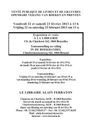
catalogue en pdf - Bibliorare
catalogue en pdf - Bibliorare
catalogue en pdf - Bibliorare

You also want an ePaper? Increase the reach of your titles
YUMPU automatically turns print PDFs into web optimized ePapers that Google loves.
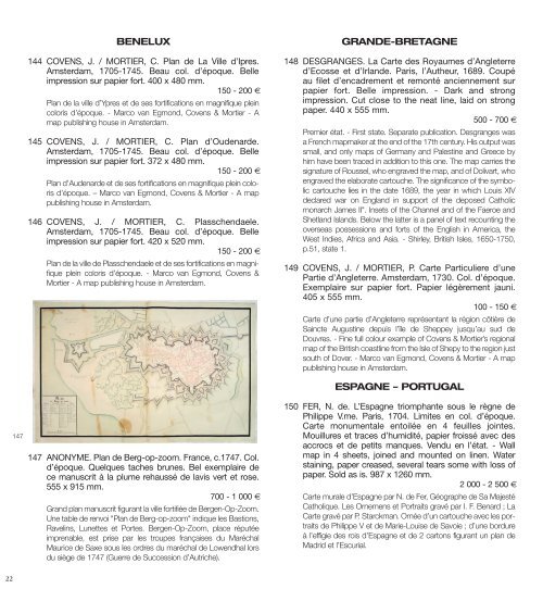
22<br />
147<br />
BENELUX<br />
144 COVENS, J. / MORTIER, C. Plan de La Ville d’Ipres.<br />
Amsterdam, 1705-1745. Beau col. d’époque. Belle<br />
impression sur papier fort. 400 x 480 mm.<br />
150 - 200 €<br />
Plan de la ville d’Ypres et de ses fortifications <strong>en</strong> magnifique plein<br />
coloris d’époque. - Marco van Egmond, Cov<strong>en</strong>s & Mortier - A<br />
map publishing house in Amsterdam.<br />
145 COVENS, J. / MORTIER, C. Plan d’Oud<strong>en</strong>arde.<br />
Amsterdam, 1705-1745. Beau col. d’époque. Belle<br />
impression sur papier fort. 372 x 480 mm.<br />
150 - 200 €<br />
Plan d’Aud<strong>en</strong>arde et de ses fortifications <strong>en</strong> magnifique plein coloris<br />
d’époque. – Marco van Egmond, Cov<strong>en</strong>s & Mortier - A map<br />
publishing house in Amsterdam.<br />
146 COVENS, J. / MORTIER, C. Plassch<strong>en</strong>daele.<br />
Amsterdam, 1705-1745. Beau col. d’époque. Belle<br />
impression sur papier fort. 420 x 520 mm.<br />
150 - 200 €<br />
Plan de la ville de Plassch<strong>en</strong>daele et de ses fortifications <strong>en</strong> magnifique<br />
plein coloris d’époque. - Marco van Egmond, Cov<strong>en</strong>s &<br />
Mortier - A map publishing house in Amsterdam.<br />
147 ANONYME. Plan de Berg-op-zoom. France, c.1747. Col.<br />
d’époque. Quelques taches brunes. Bel exemplaire de<br />
ce manuscrit à la plume rehaussé de lavis vert et rose.<br />
555 x 915 mm.<br />
700 - 1 000 €<br />
Grand plan manuscrit figurant la ville fortifiée de Berg<strong>en</strong>-Op-Zoom.<br />
Une table de r<strong>en</strong>voi "Plan de Berg-op-zoom" indique les Bastions,<br />
Ravelins, Lunettes et Portes. Berg<strong>en</strong>-Op-Zoom, place réputée<br />
impr<strong>en</strong>able, est prise par les troupes françaises du Maréchal<br />
Maurice de Saxe sous les ordres du maréchal de Low<strong>en</strong>dhal lors<br />
du siège de 1747 (Guerre de Succession d’Autriche).<br />
GRANDE-BRETAGNE<br />
148 DESGRANGES. La Carte des Royaumes d’Angleterre<br />
d’Ecosse et d’Irlande. Paris, l’Autheur, 1689. Coupé<br />
au filet d’<strong>en</strong>cadrem<strong>en</strong>t et remonté anci<strong>en</strong>nem<strong>en</strong>t sur<br />
papier fort. Belle impression. - Dark and strong<br />
impression. Cut close to the neat line, laid on strong<br />
paper. 440 x 555 mm.<br />
500 - 700 €<br />
Premier état. - First state. Separate publication. Desgranges was<br />
a Fr<strong>en</strong>ch mapmaker at the <strong>en</strong>d of the 17th c<strong>en</strong>tury. His output was<br />
small, and only maps of Germany and Palestine and Greece by<br />
him have be<strong>en</strong> traced in addition to this one. The map carries the<br />
signature of Roussel, who <strong>en</strong>graved the map, and of Dolivart, who<br />
<strong>en</strong>graved the elaborate cartouche. The significance of the symbolic<br />
cartouche lies in the date 1689, the year in which Louis XIV<br />
declared war on England in support of the deposed Catholic<br />
monarch James II". Insets of the Channel and of the Faeroe and<br />
Shetland Islands. Below the latter is a panel of text recounting the<br />
overseas possessions and forts of the English in America, the<br />
West Indies, Africa and Asia. - Shirley, British Isles, 1650-1750,<br />
p.51, state 1.<br />
149 COVENS, J. / MORTIER, P. Carte Particuliere d’une<br />
Partie d’Angleterre. Amsterdam, 1730. Col. d’époque.<br />
Exemplaire sur papier fort. Papier légèrem<strong>en</strong>t jauni.<br />
405 x 555 mm.<br />
100 - 150 €<br />
Carte d’une partie d’Angleterre représ<strong>en</strong>tant la région côtière de<br />
Saincte Augustine depuis l’île de Sheppey jusqu’au sud de<br />
Douvres. - Fine full colour example of Cov<strong>en</strong>s & Mortier’s regional<br />
map of the British coastline from the Isle of Shepy to the region just<br />
south of Dover. - Marco van Egmond, Cov<strong>en</strong>s & Mortier - A map<br />
publishing house in Amsterdam.<br />
ESPAGNE – PORTUGAL<br />
150 FER, N. de. L’Espagne triomphante sous le règne de<br />
Philippe V.me. Paris, 1704. Limites <strong>en</strong> col. d’époque.<br />
Carte monum<strong>en</strong>tale <strong>en</strong>toilée <strong>en</strong> 4 feuilles jointes.<br />
Mouillures et traces d’humidité, papier froissé avec des<br />
accrocs et de petits manques. V<strong>en</strong>du <strong>en</strong> l’état. - Wall<br />
map in 4 sheets, joined and mounted on lin<strong>en</strong>. Water<br />
staining, paper creased, several tears some with loss of<br />
paper. Sold as is. 987 x 1260 mm.<br />
2 000 - 2 500 €<br />
Carte murale d’Espagne par N. de Fer, Géographe de Sa Majesté<br />
Catholique. Les Ornem<strong>en</strong>s et Portraits gravé par I. F. B<strong>en</strong>ard ; La<br />
Carte gravé par P. Starckman. Ornée d’un cartouche avec les portraits<br />
de Philippe V et de Marie-Louise de Savoie ; d’une bordure<br />
à l’effigie des rois d’Espagne et de 2 cartons figurant un plan de<br />
Madrid et l’Escurial.