

opération de cartographie sur l'epave du cap la ... - ImageShack
opération de cartographie sur l'epave du cap la ... - ImageShack
opération de cartographie sur l'epave du cap la ... - ImageShack

Create successful ePaper yourself
Turn your PDF publications into a flip-book with our unique Google optimized e-Paper software.
Photo Stéphan AUBERT<br />
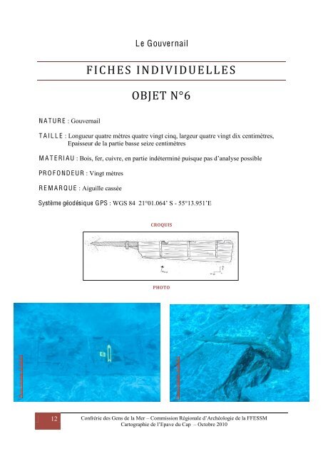
N A T UR E : Gouvernail<br />
12<br />
Le Gouvernail<br />
FICHES INDIVIDUELLE S<br />
OBJET N°6<br />
T A I L L E : Longueur quatre mètres quatre vingt cinq, <strong>la</strong>rgeur quatre vingt dix centimètres,<br />
Epaisseur <strong>de</strong> <strong>la</strong> partie basse seize centimètres<br />
M A T E RI A U : Bois, fer, cuivre, en partie indéterminé puisque pas d’analyse possible<br />
PR O F O ND E UR : Vingt mètres<br />
R E M A R Q U E : Aiguille cassée<br />
Système géodésique GPS : WGS 84 21°01.064’ S - 55°13.951’E<br />
CROQUIS<br />
PHOTO<br />
Photo Stéphan AUBERT<br />
Photo Stéphan AUBERT<br />
Confrérie <strong>de</strong>s Gens <strong>de</strong> <strong>la</strong> Mer – Commission Régionale d’Archéologie <strong>de</strong> <strong>la</strong> FFESSM<br />
Cartographie <strong>de</strong> l’Epave <strong>du</strong> Cap – Octobre 2010