Manuel de Capitalisation des Expériences 2012.pdf - Africa ...
Manuel de Capitalisation des Expériences 2012.pdf - Africa ...
Manuel de Capitalisation des Expériences 2012.pdf - Africa ...

You also want an ePaper? Increase the reach of your titles
YUMPU automatically turns print PDFs into web optimized ePapers that Google loves.
Programme d’Adaptation en Afrique<br />
<strong>Manuel</strong> sur la <strong>Capitalisation</strong> <strong>de</strong>s Expériences 2012<br />
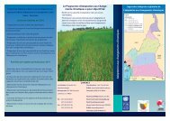
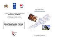
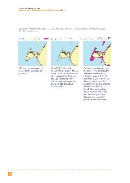
Illustration 7 : Cartographie <strong>de</strong>s zones vulnérables aux inondations dues aux changements climatiques,<br />
République <strong>de</strong> Maurice<br />
Sea Mainland Inundation prone area<br />
Road<br />
Inundation contour<br />
0 0.5 1 2 km<br />
GIS map showing part of<br />
the coast of Mauritius at<br />
present.<br />
The DDR Project will<br />
<strong>de</strong>termine the extent of sea<br />
water intrusion in the future.<br />
This will be done throught<br />
the use of appropriate<br />
climate mo<strong>de</strong>ling and the<br />
use of digital elevation<br />
mo<strong>de</strong>l in GIS.<br />
By using spatial analysis in<br />
the GIS, it will be possible<br />
ton know wich coastal<br />
infrastructures will be at<br />
risk from S.L.R. That is, all<br />
those infrastrutures (e. g.<br />
roads) in the purple sha<strong>de</strong>d<br />
area will be affected by<br />
S.L.R. This information<br />
could be inclu<strong>de</strong>d in the<br />
national land planning<br />
documents, to ensure<br />
proper implementation.<br />
34