Le mont Nicol-Albert - Sentier international des Appalaches
Le mont Nicol-Albert - Sentier international des Appalaches
Le mont Nicol-Albert - Sentier international des Appalaches
- TAGS
- mont
- sentier
- appalaches

Create successful ePaper yourself
Turn your PDF publications into a flip-book with our unique Google optimized e-Paper software.
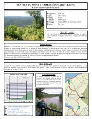
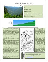
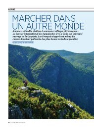
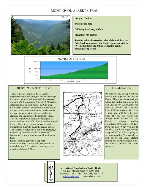
« MONT NICOL-ALBERT » TRAIL<strong>Le</strong>ngth: 12,4 kmType: round-tripDifficulty level: very difficultElevation: 750 metresStarting point: the starting point of the trail is at thePetit-Sault campsite, at the Route 1 junction with theIAT (53 km from the John registration centre)Parking along Route 1.PROFILE OF THE HIKEDESCRIPTION OF THE HIKEThe ascension of the <strong>mont</strong> <strong>Nicol</strong>-<strong>Albert</strong>represents one of the strongest hiking challengein Quebec with its 745 metres of elevation on adistance of 6,2 kilometres. The <strong>Nicol</strong>-<strong>Albert</strong> trailoffers multiple interest points: the Cap-ChatRiver at the bottom, the numerous waterfalls ofthe spectacular ruisseau Beaulieu, and towardsthe top, numerous viewpoints as well as thecrevasse and the famous “bonhomme” (man).This last attraction is accessible through a 90metres trail and it is difficult to access because ofits incredibly steep <strong>des</strong>cent. A rope is madeavailable for hikers to make the access easier.The effort is rewarded by a curiosité géologiquesculpted by the wind, called “bonhomme”because of its shape which resembles a humanface.Retrace steps to get back to the start.Alternative: For a shorter hike, only reach thesecond stream, 3,6 km further, which gives around-trip hike of 7,2 km.LOCALISATIONOn highway 132 in Cap-Chat youhave to turn right on the rue <strong>des</strong>Fonds. This street is located justbefore the bridge that crosses theCap-Chat River. Afterwards, youhave to follow the Cap-ChatRiver ZEC indications. After 2 or3 kms, you will have to keepright. The rue <strong>des</strong> Fonds willchange name for the rue <strong>des</strong>Érables… always headingtowards the ZEC which is 10 kmsfrom the 132. When you get tothe ZEC, you have to go througha pay toll of 7.41$. Keep going onthe same road for 28 kms and youwill get to the Chute Hélèneparking lot. The parking lot is 50-60 metres before the trailentrance.International Appalachian Trail – QuebecCP 132, Matane (Quebec) G4W 3N1Phone (418) 562-7885 Fax (418) 566-2115info@sia-iat.com www.sia-iat.com