Manuel Utilisateur de QGIS 1.6 - Free
Manuel Utilisateur de QGIS 1.6 - Free
Manuel Utilisateur de QGIS 1.6 - Free
You also want an ePaper? Increase the reach of your titles
YUMPU automatically turns print PDFs into web optimized ePapers that Google loves.
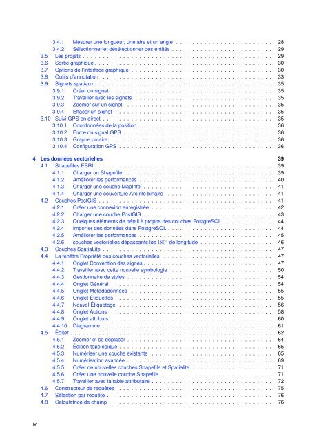
3.4.1 Mesurer une longueur, une aire et un angle . . . . . . . . . . . . . . . . . . . . . . . . 283.4.2 Sélectionner et désélectionner <strong>de</strong>s entités . . . . . . . . . . . . . . . . . . . . . . . . . 293.5 Les projets . . . . . . . . . . . . . . . . . . . . . . . . . . . . . . . . . . . . . . . . . . . . . . . 293.6 Sortie graphique . . . . . . . . . . . . . . . . . . . . . . . . . . . . . . . . . . . . . . . . . . . . 303.7 Options <strong>de</strong> l’interface graphique . . . . . . . . . . . . . . . . . . . . . . . . . . . . . . . . . . . 303.8 Outils d’annotation . . . . . . . . . . . . . . . . . . . . . . . . . . . . . . . . . . . . . . . . . . 333.9 Signets spatiaux . . . . . . . . . . . . . . . . . . . . . . . . . . . . . . . . . . . . . . . . . . . . 353.9.1 Créer un signet . . . . . . . . . . . . . . . . . . . . . . . . . . . . . . . . . . . . . . . . 353.9.2 Travailler avec les signets . . . . . . . . . . . . . . . . . . . . . . . . . . . . . . . . . . 353.9.3 Zoomer sur un signet . . . . . . . . . . . . . . . . . . . . . . . . . . . . . . . . . . . . 353.9.4 Effacer un signet . . . . . . . . . . . . . . . . . . . . . . . . . . . . . . . . . . . . . . . 353.10 Suivi GPS en direct . . . . . . . . . . . . . . . . . . . . . . . . . . . . . . . . . . . . . . . . . . 353.10.1 Coordonnées <strong>de</strong> la position . . . . . . . . . . . . . . . . . . . . . . . . . . . . . . . . . 363.10.2 Force du signal GPS . . . . . . . . . . . . . . . . . . . . . . . . . . . . . . . . . . . . . 363.10.3 Graphe polaire . . . . . . . . . . . . . . . . . . . . . . . . . . . . . . . . . . . . . . . . 363.10.4 Configuration GPS . . . . . . . . . . . . . . . . . . . . . . . . . . . . . . . . . . . . . . 364 Les données vectorielles 394.1 Shapefiles ESRI . . . . . . . . . . . . . . . . . . . . . . . . . . . . . . . . . . . . . . . . . . . . 394.1.1 Charger un Shapefile . . . . . . . . . . . . . . . . . . . . . . . . . . . . . . . . . . . . 394.1.2 Améliorer les performances . . . . . . . . . . . . . . . . . . . . . . . . . . . . . . . . . 404.1.3 Charger une couche MapInfo . . . . . . . . . . . . . . . . . . . . . . . . . . . . . . . . 414.1.4 Charger une couverture ArcInfo binaire . . . . . . . . . . . . . . . . . . . . . . . . . . 414.2 Couches PostGIS . . . . . . . . . . . . . . . . . . . . . . . . . . . . . . . . . . . . . . . . . . . 414.2.1 Créer une connexion enregistrée . . . . . . . . . . . . . . . . . . . . . . . . . . . . . . 424.2.2 Charger une couche PostGIS . . . . . . . . . . . . . . . . . . . . . . . . . . . . . . . . 434.2.3 Quelques éléments <strong>de</strong> détail à propos <strong>de</strong>s couches PostgreSQL . . . . . . . . . . . . 444.2.4 Importer <strong>de</strong>s données dans PostgreSQL . . . . . . . . . . . . . . . . . . . . . . . . . . 444.2.5 Améliorer les performances . . . . . . . . . . . . . . . . . . . . . . . . . . . . . . . . . 454.2.6 couches vectorielles dépassants les 180 ◦ <strong>de</strong> longitu<strong>de</strong> . . . . . . . . . . . . . . . . . . 464.3 Couches SpatiaLite . . . . . . . . . . . . . . . . . . . . . . . . . . . . . . . . . . . . . . . . . . 474.4 La fenêtre Propriété <strong>de</strong>s couches vectorielles . . . . . . . . . . . . . . . . . . . . . . . . . . . 474.4.1 Onglet Convention <strong>de</strong>s signes . . . . . . . . . . . . . . . . . . . . . . . . . . . . . . . . 474.4.2 Travailler avec cette nouvelle symbologie . . . . . . . . . . . . . . . . . . . . . . . . . 504.4.3 Gestionnaire <strong>de</strong> styles . . . . . . . . . . . . . . . . . . . . . . . . . . . . . . . . . . . . 544.4.4 Onglet Général . . . . . . . . . . . . . . . . . . . . . . . . . . . . . . . . . . . . . . . . 544.4.5 Onglet Métadadonnées . . . . . . . . . . . . . . . . . . . . . . . . . . . . . . . . . . . 554.4.6 Onglet Étiquettes . . . . . . . . . . . . . . . . . . . . . . . . . . . . . . . . . . . . . . . 554.4.7 Nouvel Étiquetage . . . . . . . . . . . . . . . . . . . . . . . . . . . . . . . . . . . . . . 564.4.8 Onglet Actions . . . . . . . . . . . . . . . . . . . . . . . . . . . . . . . . . . . . . . . . 584.4.9 Onglet attributs . . . . . . . . . . . . . . . . . . . . . . . . . . . . . . . . . . . . . . . . 604.4.10 Diagramme . . . . . . . . . . . . . . . . . . . . . . . . . . . . . . . . . . . . . . . . . . 614.5 Éditer . . . . . . . . . . . . . . . . . . . . . . . . . . . . . . . . . . . . . . . . . . . . . . . . . . 624.5.1 Zoomer et se déplacer . . . . . . . . . . . . . . . . . . . . . . . . . . . . . . . . . . . . 644.5.2 Édition topologique . . . . . . . . . . . . . . . . . . . . . . . . . . . . . . . . . . . . . . 654.5.3 Numériser une couche existante . . . . . . . . . . . . . . . . . . . . . . . . . . . . . . 654.5.4 Numérisation avancée . . . . . . . . . . . . . . . . . . . . . . . . . . . . . . . . . . . . 694.5.5 Créer <strong>de</strong> nouvelles couches Shapefile et Spatialite . . . . . . . . . . . . . . . . . . . . 714.5.6 Créer une nouvelle couche Shapefile . . . . . . . . . . . . . . . . . . . . . . . . . . . . 714.5.7 Travailler avec la table attributaire . . . . . . . . . . . . . . . . . . . . . . . . . . . . . . 724.6 Constructeur <strong>de</strong> requêtes . . . . . . . . . . . . . . . . . . . . . . . . . . . . . . . . . . . . . . 754.7 Sélection par requête . . . . . . . . . . . . . . . . . . . . . . . . . . . . . . . . . . . . . . . . . 764.8 Calculatrice <strong>de</strong> champ . . . . . . . . . . . . . . . . . . . . . . . . . . . . . . . . . . . . . . . . 76iv


