INSTRUMENT FOR PRE -ACCESSION ASSISTANCE - Istra
INSTRUMENT FOR PRE -ACCESSION ASSISTANCE - Istra
INSTRUMENT FOR PRE -ACCESSION ASSISTANCE - Istra

You also want an ePaper? Increase the reach of your titles
YUMPU automatically turns print PDFs into web optimized ePapers that Google loves.
<strong>INSTRUMENT</strong> <strong>FOR</strong> <strong>PRE</strong>-<strong>ACCESSION</strong> <strong>ASSISTANCE</strong><br />
apple<br />
REPUBLIKA SLOVENIJA<br />
SLUŽBA VLADE RS ZA LOKALNO SAMOUPRAVO<br />
IN REGIONALNO POLITIKO<br />
e project activity<br />
is implemented<br />
by Istria County
CIP – Katalogizacija u publikaciji<br />
Sveučilišna knjižnica u Puli<br />
UDK 711.523.025.4(497.5-3 <strong>Istra</strong>)<br />
BRADANOVIĆ, Marijan<br />
Istria : i centri storici delle citta =<br />
historic urban cores / . – Pula : Regione Istriana<br />
= Istria County , 2011.<br />
Tekst usporedo na tal. i engl. jeziku. –<br />
Bibliografija.<br />
ISBN 978-953-7001-21-6 (Mara)
RIVITALIZZAZIONE<br />
DELL'ENTROTERRA<br />
ISTRIANO E DEL<br />
SUO TURISMO<br />
REVITALISATION OF THE<br />
ISTRIAN HINTERLAND<br />
AND TOURISM IN THE<br />
ISTRIAN HINTERLAND<br />
REVITALIZACIJA<br />
ISTARSKOG ZALEĐA<br />
I TURIZMA<br />
U ISTARSKOM ZALEĐU<br />
REVITALIZACIJA<br />
ISTRSKEGA PODEŽELJA<br />
IN TURIZMA<br />
NA ISTRSKEM PODEŽELJU<br />
<strong>INSTRUMENT</strong> <strong>FOR</strong> <strong>PRE</strong>-<strong>ACCESSION</strong> <strong>ASSISTANCE</strong><br />
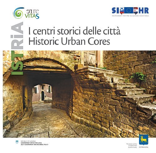
ISTRIA<br />
I centri storici delle città<br />
Historic Urban Cores<br />
is publication has been produced with the assistance of the European Union.<br />
e contents of this publication are the sole responsibility of Istria County and can in no way be taken to reflect the views of the European Union.<br />
e project activity<br />
is implemented<br />
by Istria County
LE CITTÀ ISTRIANE NELLA STORIA 6<br />
THE HISTORICAL PATH OF ISTRIAN TOWNS 8<br />
Capodistria / Koper 10<br />
Isola d’Istria / Izola 16<br />
Pirano / Piran 20<br />
Costabona / Koštabona 25<br />
Popecchio / Podpeč 27<br />
Umago / Umag 29<br />
Cittanova / Novigrad 33<br />
Buie / Buje 38<br />
Portole / Oprtalj 42<br />
Montona / Motovun 48<br />
Pinguente / Buzet 53<br />
Parenzo / Poreč 57<br />
Orsera / Vrsar 63<br />
San Lorenzo del Pasenatico / Sveti Lovreč 66<br />
Rovigno / Rovinj 68<br />
Pola / Pula 73<br />
Barbana / Barban 82<br />
Pisino / Pazin 84<br />
Albona / Labin 87<br />
Dignano / Vodnjan 91<br />
BIBLIOGRAFIA / BIBLIOGRAPHY 95
Savudrija / Salvore<br />
UMAG / UMAGO<br />
PIRAN / PIRANO<br />
Dajla / Daila<br />
Karpinjan / Carpignano<br />
NOVIGRAD / CITTANOVA<br />
Seget /<br />
Seghetto<br />
POREČ / PARENZO<br />
Vrsar / Orsera<br />
ROVINJ / ROVIGNO<br />
KOPER / CAPODISTRIA<br />
IZOLA / ISOLA<br />
BUJE / BUIE<br />
TRIESTE / TRST<br />
Koštabona / Costabona<br />
Oprtalj / Portole<br />
Motovun / Montona<br />
Sv. Lovreč /<br />
S. Lorenzo del Pasenatico<br />
Kamenjak<br />
BUZET / PINGUENTE<br />
PAZIN / PISINO<br />
Svetvinčenat /<br />
Sanvincenti<br />
Barban / Barbana<br />
VODNJAN /<br />
DIGNANO<br />
PULA / POLA<br />
Pomer<br />
Podpeč / Popecchio<br />
LABIN / ALBONA<br />
RIJEKA / FIUME<br />
0 10
Le città istriane nella storia<br />
Considerato che sono sorti su un sostrato di dimore preistoriche e castellieri,<br />
tutti i nuclei storici delle città situate nell’entroterra istriano evidenziano una<br />
presenza umana costante nel tempo. D’altronde questo fatto deriva dalle necessità<br />
di uno stanziamento stabile, per cui anche nel passato si individuavano i luoghi in<br />
altura, facilmente difendibili e difficilmente conquistabili: lo testimoniano gli oltre<br />
quattrocento ruderi di castellieri risalenti all’età del bronzo e del ferro.<br />
Ai tempi del dominio romano i piccoli insediamenti subiscono alcune modifiche:<br />
a partire dalla seconda metà del I secolo a.C., grazie all’instaurarsi di un periodo di<br />
pace (Pax Romana), le popolazioni latina e autoctona histrica si espandono nei<br />
territori circostanti i castellieri e innalzano complessi abitativi sostenuti dalle attività<br />
economiche proprie di un fertile terreno agricolo. Ville rustiche di questo genere si<br />
costruiscono lungo tutta la costa; soltanto alcune si fortificano nel periodo tardoantico<br />
per offrire protezione agli abitanti delle ville limitrofe con i rispettivi insediamenti.<br />
In ogni caso, si suppone che i castellieri non furono del tutto abbandonati:<br />
alcuni servirono da punti di controllo sulle principali vie di terra e di mare, altri<br />
sopravvissero come centri di comunità rurali autoctone.<br />
In Istria, le città antiche a pianta organica sono pochissime: tra queste si segnala<br />
Parenzo, ideata secondo i criteri dell’urbanistica romana. Gli altri nuclei urbani, invece,<br />
continuano a mantenere il loro schema preistorico anche in epoche più tarde.<br />
Nel periodo antecedente le incursioni barbariche (Unni, Longobardi, Slavi e Avari), le<br />
fiorenti città costiere diventano rifugi per i profughi provenienti non solo dagli agri,<br />
ma anche da zone continentali più distanti. Nel Medioevo i vari “castrum” di fondazione<br />
tardo-antica sulla costa e i castellieri di un tempo si evolvono in città fortificate.<br />
Ancora una volta è decisiva la configurazione del territorio. Oltre alle alture, anche le<br />
piccole penisole e le isole in prossimità della costa si prestano bene a scopi difensivi.<br />
Nel corso dei secoli le fortezze si ammodernano, si ampliano e si consolidano in<br />
conseguenza di un incessante pericolo di guerra: questa regione era infatti contesa<br />
dai signori dei numerosi feudi locali e dalla vicina Venezia che si faceva sempre più<br />
potente. I vecchi mastri costruttori progettavano le fortificazioni ponderando vari<br />
fattori: tenevano in debito conto la morfologia del terreno e valutavano la prove-<br />
6 I CENTRI STORICI DELLE CITTÀ<br />
nienza delle presunte forze avversarie più agguerrite. Le lotte costanti tra feudatari<br />
per il controllo delle città – che dal canto loro difendevano strenuamente la loro<br />
autonomia – lasciarono tracce evidenti dei molti interventi migliorativi sulle fortificazioni.<br />
Verso la fine del Medioevo, visto l’evolversi dell’arte della guerra e delle<br />
armi, le torri quadrate furono rimpiazzate da torri rotonde; successivamente si costruirono<br />
dei bastioni poligonali riempiti di terra e finalizzati alla difesa dall’artiglieria<br />
pesante sempre più sofisticata.<br />
Dopo la suddivisione definitiva della penisola istriana in due parti, sulla spinta di un<br />
nuovo impulso dell’economia, nel XV secolo le città iniziano a espandersi al di fuori<br />
delle mura medievali. Si creano nuovi rioni. Tuttavia, gli avvenimenti bellici sulla<br />
scena europea (la Lega di Cambrais, la guerra degli Uscocchi, la lotta fra Venezia e i<br />
Turchi per i possedimenti d’oltremare) condizionano un costante perfezionamento<br />
e rafforzamento delle mura. I mutamenti stilistici sono meno evidenti e più raffinati:<br />
ad esempio, le porte cittadine passano da forme romaniche (arco a tutto sesto) a<br />
forme gotiche (arco a sesto acuto) e approdano quindi ai classici lineamenti rinascimentali<br />
o alle sfarzose fisionomie barocche. Di regola vi si trovano apposti i simboli<br />
dei sovrani (l’aquila asburgica, il leone veneziano) o di qualche intraprendente<br />
rappresentante locale desideroso di lasciare una traccia di sé nella storia; nell’Istria<br />
veneziana ritroviamo lo stemma del podestà e nell’Istria austriaca (Principato di Pisino)<br />
quello del capitano o feudatario locale.<br />
Per quanto siano importanti, le mura difensive non sono l’unico elemento che fa<br />
di un insediamento una città. La città è caratterizzata anche dall’elemento della<br />
loggia: molto spesso ne ritroviamo più di una, poste in genere davanti alle mura,<br />
accanto alla porta cittadina e, nelle piazze centrali, sui palazzi comunali, sui fondaci<br />
(comunemente definiti granai), nonché sulle chiese quali centri di vita religiosa. In<br />
conformità con i modelli urbanistici veneziani, nel corso del XV secolo si sviluppano<br />
in particolare le piazze e le piazzette come centro di aggregazione urbano.<br />
La città è naturalmente costituita anche dai suoi abitanti e dal loro sistema di organizzazione<br />
e convivenza. Le fonti storiche attestano che le associazioni dei cittadini<br />
ricoprivano un rilevante ruolo sociale. È questo il caso delle confraternite che
appresentavano determinati gruppi d’interesse (spesso corporazioni di pescatori,<br />
marinai, artigiani). Per lo più costruivano chiese di dimensioni minori e le impreziosivano<br />
con opere d’arte: retabli d’altare, pale, oggetti liturgici e preziosi paramenti<br />
sacri intessuti e ricamati a mano. I membri delle confraternite raccoglievano inoltre<br />
fondi per fi nanziare interventi più consistenti, ad esempio la costruzione di nuove<br />
chiese parrocchiali e di campanili, il cui ruolo difensivo era tanto importante<br />
quanto quello religioso. E non si dimentichi l’importanza degli ordini religiosi: dai<br />
benedettini che per primi entrano nelle città e vi fondano i loro conventi, fi no agli<br />
ordini di predicatori (francescani e domenicani) che faranno la loro comparsa a<br />
partire dal XIII secolo. All’interno delle città sorgono uno o più grossi complessi con<br />
edifi ci conventuali, una chiesa e solitamente anche dei giardini che danno respiro<br />
all’impianto urbanistico.<br />
Nella seconda metà del XVIII secolo, verso il tramonto della Repubblica di Venezia,<br />
sono già sopravvenute nuove tendenze urbanistiche che hanno modifi cato in maniera<br />
decisiva la lunga tradizione di città chiuse circondate da mura. Ormai passati<br />
i pericoli diretti dai quali le mura dovevano proteggere la città, esse rappresentano<br />
ora un ostacolo alla loro espansione e a una crescita economica e demografi ca<br />
lenta ma costante. Sono cambiati anche gli usi relativi all’abitare, quindi sulle mura<br />
sorgono nuove case, sfarzosi palazzi nobiliari, logge e belvederi rivolti al mare o alle<br />
fertili valli; scompaiono così gradualmente le rigide torri di difesa.<br />
Nonostante la sua breve durata (1805 – 1813), l’amministrazione francese segnò una<br />
svolta nel concetto di città e nei rapporti sociali. Furono aboliti i conventi, fi no ad<br />
allora cardini della vita sociale e religiosa delle città, e le chiese furono secolarizzate.<br />
Per quel che concerne l’aspetto igenico-sanitario si cominciò a demolire le mura per<br />
consentire la circolazione d’aria fresca fra le “pestilenti rovine” dei castellieri; si adottarono<br />
piani regolatori per la realizzazione di strade e l’ammodernamento dei porti.<br />
L’innovazione urbanistica continuò anche durante la Seconda amministrazione<br />
austriaca (a partire dal 1815). Nella maggior parte delle città sorsero nuovi centri<br />
amministrativi, mentre lo sviluppo industriale portò alla crescita di grossi complessi<br />
produttivi nelle zone periferiche. I nuclei storici, per secoli proporzionati alle necessità<br />
degli abitanti, non assolvono più alle loro funzioni; il benessere della Monarchia,<br />
che nel corso di cinque secoli ha unifi cato l’Istria, si rispecchia negli edifi ci monumentali<br />
che non rispettano i rapporti di spazio prestabiliti. Tra tutte le città istriane,<br />
Pola subisce uno sviluppo specifi co: dopo essere stata eletta a base marittima della<br />
Marina austriaca, si trasforma in una fortezza inespugnabile protetta per un raggio<br />
di 30 km da un sistema di fortifi cazioni che ne limiterà l’espansione nel corso degli<br />
interi secoli XIX e XX. D’altra parte, una crescita demografi ca irrefrenabile la trasforma<br />
in poco tempo in una moderna città europea.<br />
Il burrascoso XX secolo incide profondamente nell’approccio di pianifi cazione urbanistica:<br />
si costruiscono nuove reti viarie che collegano agevolmente le città preesistenti<br />
con l’aggiunta di tracciati alternativi; le due guerre mondiali si lasciano dietro<br />
tanta devastazione, compromettendo anche il tessuto urbano di molte città. Nella<br />
fase della ricostruzione postbellica, edifi ci moderni sorgono accanto alle abitazioni<br />
medievali, si aprono nuovi porti in sostituzione di quelli storici, i quartieri distrutti<br />
si trasformano in “aree verdi” trascurate, le strutture medievali ospitano alberghi di<br />
nuova generazione.<br />
Nella maggior parte degli altri casi, in particolare nelle zone interne della penisola<br />
istriana, i “tempi moderni” sfi orano appena le cittadine addormentate, dove il tempo<br />
sembra essersi fermato nel periodo a cavallo tra il Medioevo e gli inizi dell’Era<br />
Moderna, all’epoca della scoperta del Nuovo mondo.<br />
In questa sede vi presenteremo solo una piccola parte delle località più caratteristiche.<br />
Per percepire al meglio ogni singola città nel suo contesto storico sarebbe opportuno<br />
raggiungerla così come si faceva in passato: dal mare, lungo un fi ume, a piedi<br />
attraverso i monti. Non bisogna avere fretta, ma soff ermarsi per godere del panorama<br />
complessivo che questi luoghi ancor oggi off rono con i loro imponenti profi li e i<br />
campanili. Questo è l’unico modo per assaporarne la ricca storia e la cultura urbana<br />
di città fortifi cate: partendo da nord-ovest con Capodistria e Muggia poco distanti<br />
da Trieste, ci spingeremo fi no a Laurana e Castua, ubicate a est della penisola istriana.<br />
HISTORIC URBAN CORES<br />
7
e Historical Path of Istrian Towns<br />
All historic cores of Istrian towns in the interior show a distinct<br />
continuity of population since they developed on the sites of earlier prehistoric<br />
settlements, hill-forts. is is not surprising because sites that were more difficult<br />
to conquer on elevations were sought after as permanent settlements. More than<br />
four hundred traces of hill-forts on the Istrian Peninsula dating from the Bronze and<br />
Iron Age speak in favor of this fact.<br />
Urbanized landscape underwent changes under the Roman rule. Enjoying the fruits<br />
of peace (Pax Romana), the Latin and Romanized native Histrian population from<br />
the second half of the 1st c. BC started settling in the surroundings of hill-forts,<br />
erecting residential-economic complexes on the fertile farming area. Such countryside<br />
villas were built along the entire coast, but only few of them were fortified in<br />
the insecure times of Late Antiquity, hoping to provide shelter to the inhabitants of<br />
the nearby villas and settlements. It is supposed that not even hill-forts were completely<br />
deserted in Antiquity: some served as control points of main maritime or<br />
land routes, while others survived as centers of autochthonous rural communities.<br />
ere are only few planned ancient towns in Istria. With certainty this can only<br />
apply to Poreč, designed following the rules of Roman town planning, while other<br />
towns maintained the prehistoric scheme, both in Antiquity and the Middle Ages.<br />
Before the incursions of barbarians (Huns, Lombards, Slavs and Avars) in Late Antiquity,<br />
the one-time flourishing towns became shelters to refugees from the ager,<br />
and those from more distant continental areas as well. e Late Roman castrum<br />
in the coastal area and refuges on the sites of the one-time hill-forts in the interior,<br />
developed into fortified towns in the Middle Ages. e configuration of the land<br />
was decisive again. Along with elevations, small peninsulas and isles close to the<br />
coast were particularly suitable defensive positions.<br />
Over the course of centuries, fortifications were reconstructed, widened and reinforced,<br />
as a consequence of permanent war peril in the region torn apart by inter-<br />
8 I CENTRI STORICI DELLE CITTÀ<br />
ests of a number of feudal lords and the increasing power of Venice. Builders of the<br />
time skillfully adapted to the configuration of the land, foreseeing the direction of<br />
the greatest peril, which was a factor they took into consideration when building<br />
the fortifications. Constant battles of the feudal forces wishing to gain control over<br />
the towns that tried to maintain their autonomy as long as possible left deep traces<br />
in the form of multiple fortifications. At the end of the Middle Ages, with the introduction<br />
of new arms and warfare, square towers gave way to round ones. ese<br />
were in use until the appearance of new polygonal bastions that were filled with soil<br />
to defend from the fire of the advanced artillery.<br />
After the Istrian Peninsula had finally been divided into two parts, encouraged by<br />
the economic recovery, in the 15th c. towns started stretching outside the medieval<br />
walls. New quarters were created; however, the wars in Europe (League of Cambrai,<br />
Uskok War, Turkish-Venetian War for maintaining overseas lands) imposed<br />
constant reconstruction and extension of the walls. Changes in style were hardly<br />
noticeable. ey can best be seen on the town gate whose shape changes from a<br />
Romanesque round arch, pointed Gothic to classical Renaissance and elaborate Baroque<br />
forms, constantly bearing the ruler’s insignia (the Habsburg eagle, the Venetian<br />
lion) or one of its local representatives. is active representative burdened by<br />
his own historic role was in the Venetian part of Istria the podestà, and captain or<br />
local feudal lord in its Austrian part, i.e. the Pazin County.<br />
No matter how important, the defensive walls are not the only element that makes<br />
a settlement a town. ere are elements such as the loggia, often several ones,<br />
situated in front of the walls, beside the town gate and in the main town squares,<br />
communal palaces, grain storehouse (simply called granaries) and also churches<br />
as centers of religious life. In the 15th c., following the Venetian town planning<br />
models, squares, piazzas and piazzetas (small squares) were particularly developed<br />
as the town’s urban focal points. e inhabitants and their system of activity and
creating the urban life defi nitely form a town. Historic sources reveal a signifi cant<br />
social role of societies of inhabitants - confraternities that, by representing a certain<br />
interest group, most often a guild (fi shermen, seamen and craftsmen), built<br />
smaller churches, furnishing them with works of art: altar retables, palas, liturgical<br />
vessels and precious textile handicrafts and raised money for undertaking greater<br />
works such as the construction of new parish churches and belfries, whose defense<br />
role was as important as its religious one. We should not forget the role of clerical<br />
orders: from the Benedictines whose monasteries were the fi rst to enter the town,<br />
to the Order of Preachers (Franciscans, Dominicans) who appeared after the 13th<br />
c. Large complexes with monastic buildings, church and gardens built within the<br />
towns, specifi cally shaped the tissue within the condensed urban core.<br />
As early as the second half of the 18th c., near the end of the Venetian Republic,<br />
new town planning trends appeared and marked the end of the long tradition<br />
of the enclosed town embraced by walls. Direct perils which were the reason for<br />
building the walls disappeared. In fact, they became an impediment to the town’s<br />
expansion, slow but persistent economic and demographic growth. Ways of living<br />
changed, which meant new houses against the walls, magnifi cent noblemen’s palaces,<br />
loggias and belvederes facing the sea or fertile valleys, gradually replacing the<br />
massive defensive towers.<br />
Although of short duration, the French administration (1805 -1813) meant a turning<br />
point in the idea of towns and social relations. Numerous monasteries were<br />
dissolved, churches secularized, which until then, bore the social and religious life of<br />
the towns. Following the sanitary ideas of the time, walls began to be pulled down<br />
in order to enable the fl ow of fresh air between the “infectious ruins”; roads were<br />
built and plans for the regulation of ports were made.<br />
Town planning was again in full swing which continued during the Second Austrian<br />
administration (from 1815). Most towns developed into new administrative cent-<br />
ers and the growth of industry meant the erection of large production complexes<br />
on the edges. Historic cores that for centuries followed the needs of its inhabitants<br />
became too tight and the wealth of the Monarchy that after fi ve centuries united<br />
Istria, resulted in monumental buildings that did not observe the spatial relations<br />
set forth. Of all Istrian towns, Pula saw a specifi c development: having become the<br />
maritime center of the Austrian navy, it was turned into an unconquerable fortress<br />
protected by a fortifi cation system in a radius of 30 km that would restrict the development<br />
of the town throughout the 19th and 20th cc. On the other hand, the<br />
unstoppable demographic growth turned it shortly into a modern European city.<br />
e turbulent 20th c. brought about a complete transformation in respect of the<br />
town planning. A new traffi c infrastructure was built, connecting old towns by new,<br />
fast routes, while the destructions of both World Wars resulted in devastation of<br />
the urban tissue in quite a number of towns. Here and there new, for historic cores<br />
inappropriately tall buildings were built along the medieval houses, new ports<br />
closed the historic ones, destroyed town blocks became neglected “green islands”,<br />
new hotels entered the medieval structures.<br />
In most cases, especially in the interior of the Istrian Peninsula, “modern times”<br />
hardly touched the lethargic towns, completely formed in terms of town planning<br />
already at the end of the Middle Ages and the beginning of the New Age, precisely,<br />
at the time of the discovery of the New World.<br />
We present to you only a group of sites you should not miss. In order to understand<br />
a certain town within its historic context, we have to reach it just as it was done<br />
in the past: by sea, along the river, uphill on foot. We have to stop and admire the<br />
views that the mighty silhouettes with belfries off er us even nowadays. is is the<br />
only way to experience the rich history of these areas, crucially marked by the urban<br />
culture of fortifi ed towns, from Koper and Muggia near Trieste in the northwest, to<br />
Lovran and Kastav in the east of the Istrian Peninsula.<br />
HISTORIC URBAN CORES<br />
9
C a p o di s t r ia<br />
Koper<br />
Le denominazioni che la città “in capo all’Istria” ha assunto nel<br />
corso della storia recano testimonianza dei sovrani che l’hanno governata. Il<br />
nome della Capodistria preistorica – sede di un santuario illirico – è sconosciuto;<br />
la denominazione greca di Egida (Aegida), legata al mito degli Argonauti,<br />
risale al I secolo a.C.; ai tempi di Roma diventa Capris (Isola delle capre) o Insula<br />
Capraria, apprezzata per la sua posizione favorevole sulla Via Flavia e per il suo<br />
fertile entroterra; sul fi nire dell’Era Antica l’insediamento off re riparo ai profughi<br />
provenienti dalla Pannonia, dal Norico e da Tergeste: l’importante roccaforte<br />
bizantina cambia il nome in Justinopolis.<br />
Verso la fi ne dell’VIII secolo passa sotto il dominio franco, cui più tardi subentra<br />
quello tedesco. Nelle lotte che Konrad II ingaggia contro Venezia, Capodistria si<br />
schiera con l’imperatore tedesco; a ricompensa di questi servigi, nel 1035 ottiene<br />
il riconoscimento dei diritti civici, l’indipendenza dal margravio istriano e una<br />
grossa fetta di possedimenti fi no al fi ume Dragogna.<br />
Capodistria e Venezia intrecciano legami commerciali fi n dal X secolo. Nonostante<br />
che dal 1208 si trovi formalmente alle dipendenze del patriarca d’Aquileia,<br />
la città si sviluppa in autonomia diventando un’importante potenza commer-<br />
10 I CENTRI STORICI DELLE CITTÀ<br />
ciale e un soggetto politico di rilievo nell’Adriatico settentrionale, il che la<br />
pone in concorrenza con Venezia che comincia a percepirla come minaccia.<br />
Il patriarca muta il nome in Caput Ystriae, dal quale deriverà poi la versione<br />
veneziana Cao d’Istria (in it. Capodistria). La prosperità si basa, oltre<br />
che sui commerci, sulla produzione e sulla vendita di sale (Capodistria ne<br />
detiene il monopolio territoriale sin dal 1182). Visti i ripetuti tentativi veneziani<br />
d’instaurare il potere, i Capodistriani difendono coraggiosamente<br />
l’indipendenza della loro città; nel corso del XIII e XIV secolo Capodistria,<br />
alleandosi a Pola, capeggia frequenti ribellioni che avranno fi ne con la conquista<br />
e il saccheggio della città (1380).<br />
Spinto dalla ribellione del 1278 dopo la quale Capodistria viene costretta<br />
a giurare fedeltà a Venezia, il Senato ordina la costruzione della fortezza<br />
di Castel Leone.<br />
Il nucleo storico è intensamente edifi cato, con un reticolo di strette viuzze<br />
che convergono a raggiera verso la piazza centrale con la cattedrale. Lungo<br />
il perimetro delle mura si aprono otto piazze con relative chiese. Le mura,
più volte demolite e rinnovate nel corso del Medioevo, nel XV secolo furono ampliate<br />
dai Veneziani fi no ad abbracciare l’intera isola. Delle dodici porte cittadine<br />
si è conservata soltanto la Porta della Muda o del Ponte, punto di accesso dalla<br />
terraferma, presso la quale si riscuotevano i dazi sulla merce che entrava in città. Le<br />
rimanenti porte erano di collegamento ai mandracchi, i porticcioli di quel tempo.<br />
Nell’organizzazione della città, che ha assunto la forma odierna nel XIII secolo, si<br />
rifl ette la struttura sociale: al centro dell’isola si trovano le principali istituzioni cittadine<br />
e le case dei più abbienti; gli strati sociali più poveri (pescatori, commercianti e<br />
artigiani) si sono sistemati in periferia; ai margini del centro hanno trovato collocazione<br />
una serie di conventi.<br />
Gli edifi ci più antichi sono il battistero della cattedrale, la rotonda di Sant’Elio e il<br />
piccolo palazzo Percauz (XIII secolo). L’architettura delle chiese, dei conventi e degli<br />
edifi ci pubblici della città è fortemente improntata dallo stile gotico. Lo si nota nei<br />
palazzi che si susseguono lungo i vicoli, come le case Carpaccio e Gallo o il palazzo<br />
Almerigogna con la sua facciata abbellita da decorazioni variopinte. Diversi sono gli<br />
esempi di tipici edifi ci gotici dalle facciate policrome con il caratteristico avancorpo<br />
costruito su dei supporti profi lati (serie di case in Via Kidrič, casa Favento nella Calle<br />
delle Mura).<br />
Due piazze rappresentano il cuore della città. Nella piazza centrale, un tempo chiamata<br />
Platea Comunalis, sono collocati gli edifi ci di maggior rilievo. Il lato sud della<br />
piazza è chiuso dal Palazzo Pretorio. L’edifi cio, originariamente romanico, nel XV secolo<br />
viene adibito a struttura istituzionale ove si concentrano i poteri politico, militare<br />
e giudiziario del podestà e l’autogoverno cittadino. Lungo il Palazzo Pretorio si<br />
trovano l’Armeria (magazzino per le armi) e la Foresteria (“l’hotel” in cui soggiornavano<br />
gli ospiti illustri provenienti da Venezia). Sull’estremità opposta della piazza è<br />
posta una loggia del XV secolo, costruita nel punto dove ne sorgeva una più antica<br />
(XIII secolo): nel XVII secolo è stata trasformata nell’odierno edifi cio porticato a un<br />
piano. A delimitare il lato orientale è la facciata gotico-rinascimentale della cattedrale<br />
dedicata a Maria Assunta in Cielo con l’attiguo campanile, ricavato da una torre<br />
romanica modifi cata nel 1418. Alle spalle della cattedrale si apre Piazza Brolo, punto<br />
di rifornimento: qui, accanto al fondaco, era posizionata la cisterna della città; attorno<br />
al fondaco ci sono il Palazzo vescovile e una serie di palazzi nobiliari.<br />
HISTORIC URBAN CORES<br />
11
12 I CENTRI STORICI DELLE CITTÀ
Nel 1420 Venezia rileva tutti i rimanenti possedimenti istriani del patriarcato. Capodistria<br />
diventa così l’epicentro dell’espansione veneziana sull’Adriatico orientale<br />
e, insieme, la principale rivale della Trieste asburgica reggendone il confronto,<br />
tanto che fi no alla metà del XVIII secolo le due città portuali si uguagliavano<br />
nel numero di abitanti e nel volume di scambi con l’Oltremare. Si pensi che<br />
prima dell’epidemia di peste del 1554 Capodistria contava addirittura 8.000 abitanti.<br />
Dal XVI secolo viene deputata a centro amministrativo, giuridico e fi scale<br />
dell’Istria veneziana. Il relativo benessere permise di assistere gli abitanti più disagiati:<br />
a questo scopo, nel 1392 fu fondato il fondaco per il grano e i viveri, mentre<br />
verso la metà del XVI secolo fu istituito il Monte di Pietà. A Capodistria, città<br />
in cui c’era gran fermento sia in ambito religioso che intellettuale, operarono<br />
numerose confraternite e accademie.<br />
Nonostante la sua struttura medievale, Capodistria deve il suo aspetto odierno<br />
agli interventi eff ettuati in epoca rinascimentale e barocca, prevalentemente<br />
d’ispirazione veneziana. Nel corso del XVI secolo le mura e la porta, incluso Castel<br />
Leone, vennero ristrutturate in varie fasi. Oltre alla Porta del Porto tramite<br />
cui si accedeva al mandracchio principale, si costruirono due bastioni poligonali<br />
capaci di resistere agli attacchi dell’artiglieria pesante. La rinnovata Porta della<br />
Muda (1515) divenne la porta principale della città. Dal XVI al XVIII secolo<br />
sorgono una serie di conventi con le rispettive chiese (Sant’Anna, S. Nicolò) e<br />
il magazzino del sale di S. Marco (sul Molo della Porporella) lungo le mura in<br />
direzione del mandracchio. Si erigono palazzi patrizi accalcati in spazi ristretti<br />
all’interno delle contrade medievali, con piccoli corti interne e facciate dagli eleganti<br />
portali, balconi e trifore. In piazza, lungo il magazzino di sale è stata posta<br />
la Colonna di Santa Giustina con lo stemma di Capodistria, a memoria della<br />
galea capodistriana che contribuì alla vittoria di Venezia nella battaglia di Lepanto.<br />
Nel XVIII secolo scompaiono gradualmente le mura e la porta cittadina,<br />
poiché vengono usate come pareti per la costruzione di case e al loro interno si<br />
aprono dei passaggi.<br />
Sotto gli Asburgo Capodistria matura in un importante centro industriale e<br />
amministrativo. Nel XIX secolo l’isola viene collegata alla terraferma con due<br />
terrapieni, in mezzo ai quali si trovavano le saline, bonifi cate negli anni Venti del<br />
secolo scorso. Nel 1910, sotto il patrocinio della corte viennese, a Capodistria<br />
si tenne la Prima esposizione provinciale istriana allestita in numerose piazze<br />
ed edifi ci cittadini. Purtroppo, maldestri interventi urbanistici eff ettuati nella seconda<br />
metà del XX secolo, l’ampliamento della città verso il tessuto cittadino e<br />
infi ne la bonifi ca della palude hanno danneggiato in misura considerevole l’integrità<br />
urbanistica e l’immagine di aff ermata città insulare.<br />
CONSIGLIAMO DI VISITARE:<br />
Il Museo regionale di Capodistria che espone una ricca<br />
collezione archeologica e artistica.<br />
CURIOSITÀ:<br />
Il rilievo del leone alato di S. Marco (simbolo della Serenissima<br />
Repubblica di Venezia) visibile sulla facciata di palazzo Tacco-Gavardo<br />
(vi fu posto nel 1935) proviene dalla fortezza di Castel Leone.<br />
Gli ornamenti policromi delle facciate gotiche rendono un’idea<br />
di quale fosse l’aspetto della città nel XV secolo.<br />
Il sarcofago marmoreo di S. Nazario con decorazioni in rilievo<br />
è un’eccellente opera scultorea del Trecento veneziano.<br />
HISTORIC URBAN CORES<br />
13
e town at “the top of Istria” preserved the names of rulers in its historic<br />
names. Its name in prehistory, when this was the site of the Illyrian sanctuary,<br />
is unknown to us while the Greek name Egida (Aegida), bound by legend to the<br />
myth about the Argonauts, is mentioned in the 1st c. BC. It developed in Roman<br />
times as Capris (Goat Island) or Insula Capraria owing to its favorable position<br />
along the Via Flavia and the fertile land in the hinterland. At the dusk of Antiquity,<br />
it became the shelter to the refugees from Pannonia, Noricum, Tergesta. e important<br />
Byzantine fortifi cation was renamed to Justinopolis.<br />
At the end of the 8th c., it belonged to the Frankish and afterwards German rulers.<br />
In battles of German Emperor Conrad II with Venice, it took the side of the<br />
emperor, and in 1035 was granted town rights, independence from the Margrave of<br />
Istria and large estates as far as the Dragonja River.<br />
Trade between Koper and Venice was recorded as early as the 10th c. Although<br />
formally owned by the Patriarch of Aquileia since 1208, the town developed its autonomy,<br />
and became an important economic and political power of the northern<br />
Adriatic, thus a threat to Venice. e Patriarch changed its name to Caput Ystriae,<br />
14 I CENTRI STORICI DELLE CITTÀ<br />
that later yielded the Venetian variant Cao d’Istria (It. Capodistria). Apart from<br />
trade, its prosperity rested on the production and sale of salt that it monopolized<br />
in Istria since 1182. Its inhabitants ardently defended its independence during Venetian<br />
eff orts to establish its administration, and Koper along with Pula led frequent<br />
rebellions during the 13th and 14th cc. that ceased only after the town was conquered<br />
and plundered in 1380.<br />
Urged by the rebellion in 1278, after which Koper was forced to swear loyalty to<br />
Venice, the Senate ordered the construction of the fortifi cation Castel Leone.<br />
e historic core is condensed, with a grid of narrow streets radially directed towards<br />
the central square with the cathedral. Perimetrally, along the walls and the<br />
town gate, eight squares were formed with churches. Several times reconstructed<br />
and pulled down during the Middle Ages, the Venetian walls from the 15th c. embraced<br />
the entire island. Of the twelve medieval gates, only the Porta della Muda<br />
or del Ponte towards the mainland was preserved. It was the site where taxes were<br />
charged for goods entering the town. Most of the gates had a mandrač (tiny port)<br />
in front of them. e organization of the town, conceived in today’s form at the
end of the 13th c., refl ects the social structure. e public town institutions and<br />
wealthier homes were in the center of the island, while the poorer classes of fi shermen,<br />
merchants and craftsmen settled on the perimeter. Monasteries were lined<br />
along the edge of the core.<br />
e oldest preserved buildings are the Romanesque baptistery of the cathedral, the<br />
Rotunda of St. Elias, and the small Percauz House from the 13th c. e Gothic style<br />
profoundly marked the town by the architecture of its churches, monasteries and<br />
public buildings. Gothic houses were built, such as the Carpaccio and Gallo houses,<br />
and the Almerigogna Palace with its painted facade. ere are many examples of<br />
characteristic Gothic houses with a pronounced fl oor on consoles, polychromed facade<br />
(a sequence of houses in Kidričeva Street, the Favento House in Obzidna Street).<br />
e center of the town consists of two squares. e central, one-time Platea<br />
Comunalis holds the most signifi cant buildings. e southern edge of the square<br />
is enclosed by the Praetorian Palace. Originally a Romanesque building, it became<br />
a unique structure in the 15th c. uniting the political, military and judicial function<br />
of the podestà and the communal autonomy. Next to it is the Armeria (arms stor-<br />
age) and Foresteria, a “hotel” for distinguished guests from Venice. Opposite the<br />
palace is the Loggia from the 15th c. on the site of an earlier one from the 13th c.<br />
that gained its present-day appearance in the 17th c. e eastern side is enclosed by<br />
a Gothic-Renaissance facade of the Cathedral of the Assumption. Beside it stands<br />
a Romanesque Town Tower that in 1418 was turned into a church belfry. Brolo<br />
Square behind the cathedral served as a service point. e town cistern stood by<br />
the Fontico (grain storehouse), and was surrounded by the bishop’s and a number<br />
of noblemen’s palaces.<br />
In 1420 Venice took over the last remains of the Patriarch’s possessions in Istria.<br />
Koper became the center of Venetian expansion onto the eastern Adriatic and the<br />
main competition to Habsburg Trieste that it was close to by its population and<br />
overseas trade until the mid-18th c. Before the epidemic of the plague in 1554, the<br />
town had as many as 8,000 inhabitants. In the 16th c. it became the administrative,<br />
judicial and taxation center of Venetian Istria. Prosperity enabled it to care for the<br />
poorer inhabitants, which is why in 1392 a storehouse for grain and provisions was<br />
founded, and in the mid-16th c., a charity institution Monte di Pietà. e town of<br />
rich religious and intellectual life had many confraternities and academies.<br />
In spite of its medieval structure, Koper owes its appearance to Renaissance and<br />
Baroque interventions, inspired mostly by Venice. In the 16th c. the town walls and<br />
gate, including the Castel Leone, were reconstructed several times. Beside Porta<br />
del Porto in the direction of the main mandrač, two polygonal bastions were built<br />
that could resist the attacks of canons. e reconstructed Muda Gate (Porta della<br />
Muda, 1515) became the main town gate. From the 16th to 18th cc. a series of<br />
monasteries with churches were built (St. Ann, St. Nicholas) as well as a salt storehouse<br />
of St. Mark along the walls towards the Porporella madrač. e area within<br />
the medieval blocks is where noblemen’s palaces were densely built, with small inner<br />
courtyards, facades with elegant decorated portals with balconies, triforiums. On<br />
the square, beside the salt storehouse, stands the Column of St. Justine with the coat<br />
of arms of Koper marking the victory over Venice in the Battle of Lepanto in which a<br />
Koper galley took part as well. e town walls and gate gradually disappeared in the<br />
18th c. when houses were built against the walls that now gained openings.<br />
Under the Austrian rule, Koper developed into an important industrial and administrative<br />
center. In the 19th c. the island was connected to the mainland with two<br />
embankments between which were salt pans that received a bonus in the 1920s.<br />
Under the patronage of Vienna, the fi rst Istrian regional exhibition was held here,<br />
covering many town squares and buildings. Unfortunately, inappropriate town<br />
planning interventions in the second half of the 20th c., the extension of the port<br />
towards the urban tissue, and fi nally drainage of the swamp area, have signifi cantly<br />
aff ected the urban integrity and the characteristic silhouette of the powerful town<br />
on the island.<br />
VISIT:<br />
Koper Regional Museum with its rich archaeological and art collection.<br />
INTERESTING FACTS:<br />
e relief of St. Mark’s winged lion, symbol of the Venetian Republic<br />
on the Tacco-Gavardo Palace, originates from the Castel Leone fortifi cation.<br />
It was placed on the facade in 1935.<br />
e painted facades of Gothic houses reveal the one-time appearance<br />
of the town in the 15th c. e marble, relief-decorated sarcophagus<br />
of St. Nazarius is a supreme sculptural work of the Venetian Trecento.<br />
HISTORIC URBAN CORES<br />
15
Lungo la costa nord-occidentale dell’Istria, su quella che un<br />
tempo era effettivamente un’isola, sorge l’unica città del litorale istriano che<br />
può vantare una tradizione termale.<br />
Al I secolo a.C. – periodo al quale risalgono i primi insediamenti – si datano<br />
le più antiche tracce di un esteso e lussuoso complesso comprendente una<br />
villa romana e un porto sulla costa della Baia di Simone (a un chilometro<br />
dall’attuale centro abitato). Si tratta di un importante plesso economico che<br />
coesisteva con le altre ville dell’isola.<br />
Risale probabilmente all’età tardo-antica la prima fortificazione di un presidio<br />
romano, la cui vita, così protetta, prosegue anche nell’Alto Medioevo.<br />
Nel 972 l’imperatore Ottone I dona Isola al doge veneziano, ma il territorio<br />
passa ben presto al Patriarcato d’Aquileia. Nel 1031 il potente patriarca Popone<br />
la dona a sua volta alle benedettine del convento di S. Maria in Aquileia:<br />
erano loro a riscuotere le decime per tramite di loro un delegato fiduciario.<br />
Erano solite annotare tutti gli accadimenti del luogo: il loro archivio custodisce,<br />
tra l’altro, i documenti relativi al convento delle benedettine di S. Pietro<br />
(prima menzione a Isola nel XIII secolo) e al convento di S. Caterina (presente<br />
in Isola dal XV secolo in poi, a meno che non si tratti del convento precedente<br />
che ha cambiato intitolazione). I secoli contemplati in queste memorie<br />
rappresentano tempi duri per Isola, perché segnati dalla costante rivalità con<br />
Capodistria e Pirano, spesso sfociata in aperta lotta. L’autonomia, conquistata<br />
nella metà del XIII secolo, avrà breve durata: già nel 1280 Isola cade sotto<br />
il dominio veneziano.<br />
Nei secoli XV e XVI si intensifica la ristrutturazione e la costruzione delle<br />
chiese. Nello stesso lasso temporale si edifica Palazzo Manzioli (1470), la cui<br />
parte ristrutturata nel Rinascimento è denominata Palazzo Lovisato, si erige<br />
il palazzo comunale, si ampliano la basilica di S. Mauro (1547) e la vecchia<br />
chiesa parrocchiale ottagonale di S. Maria d’Alieto (1553), si costruisce il con-<br />
16 I CENTRI STORICI DELLE CITTÀ<br />
ISOL A D I S T R I A<br />
IZOL A<br />
vento francescano. Un nuovo impulso edilizio si ha nel XVIII secolo, quando<br />
si ristruttura la chiesa di S. Maria d’Alieto e, ai limiti del nucleo medievale,<br />
s’innalza il lussuoso palazzo della famiglia Besenghi degli Ughi. Nel XIX secolo<br />
l’aspetto della cittadella medievale viene stravolto: all’inizio del secolo vengono<br />
smantellate le mura di difesa, utilizzando il materiale di risulta per colmare<br />
il canale che separava l’isola dalla terraferma. La metamorfosi architettonica<br />
non è l’unica novità: la scoperta di una sorgente d’acqua termale nei pressi<br />
della chiesa di S. Pietro incide sullo sviluppo di Isola. Le terme, dotate di sala<br />
da ballo e altri contenuti, vengono inaugurate già nel 1824 e trasformano la<br />
località in una popolare meta di villeggiatura. In epoca successiva le terme<br />
vengono ristrutturate in uno stabilimento per la conservazione del pesce che<br />
s’installa nella seconda metà del secolo, diventando presto una nuova fonte<br />
di guadagno per la cittadinanza.<br />
A dispetto delle vicende belliche del XX secolo, dopo gli anni Cinquanta<br />
l’economia di Isola è in netta espansione, sostenuta da specifiche branche<br />
produttive fra cui spicca la fabbrica di giocattoli Mehanotehnika.<br />
CONSIGLIAMO DI VISITARE:<br />
Il Museo della Parenzana, ferrovia a scartamento ridotto che dal 1902 al<br />
1935 ha collegato Trieste e Parenzo toccando varie stazioni intermedie.<br />
CURIOSITÀ:<br />
Nel 1499 si trasferisce a Isola il noto cartografo Pietro Coppo.<br />
Nella sua opera Del sito de Listria riporta la mappa della penisola: una<br />
riproduzione di questa mappa scolpita nella pietra è in mostra nel<br />
Parco “Pietro Coppo”, giardino pubblico in centro città. L’intera collezione<br />
delle sue tavole è invece conservata nel Museo marittimo di Pirano.
On the northwestern coast of Istria on the one-time island, lies<br />
the only Istrian coastal town that boasts a history of thermal tourism.<br />
It was inhabited in the 1st c. BC which is the period that the oldest traces<br />
of the large luxurious complex with a Roman villa and pier on the seaside<br />
in Simon’s Bay, only a kilometer from Izola, date from. It was an important<br />
economic complex that coexisted with other villas on the island.<br />
e Roman settlement was for the fi rst time fortifi ed probably in the Late<br />
Roman period, and life continued on in the Early Middle Ages in the protected<br />
settlement. In 972 Emperor Otto I granted Izola to the Venetian dodge,<br />
but it soon became property of the Patriarch of Aquileia. In 1031 the mighty<br />
Patriarch of Aquileia Popone granted it to the Monastery of Benedictine<br />
nuns of St. Mary in Aquileia. ey collected the tithe, while the civil government<br />
was entrusted to its own administrator. ey kept records of all events:<br />
their archives contain documents about the Benedictine monastery of St.<br />
Peter that was mentioned in the 13th c., and about St. Catherine’s monastery,<br />
mentioned since the 15th c., unless it was the same monastery that<br />
changed its titular. e centuries between these records were diffi cult times<br />
for Izola, marked with constant rivalry and battles with Koper and Piran. e<br />
independence it obtained in the mid-13th c. lasted shortly: as early as 1280<br />
the town was under Venice.<br />
e renovation and construction of churches and palaces intensifi ed in the<br />
15th and 16th cc. is is when the Manzioli Palace (1470) was built, part<br />
of which in the Renaissance was renamed to Lovisato Palace. Further, the<br />
Communal Palace was built, St. Maurus Basilica was enlarged (1547), the old<br />
octagonal Parish Church of St. Mary of Haliaetum was reconstructed (1553),<br />
and the Franciscan monastery was built. e repeated construction swing<br />
took place in the 18th c. when the Church of St. Mary of Haliaetum was<br />
reconstructed, while the edge of the medieval core became the site of a new<br />
luxurious palace of the Besenghi degli Ughi family. e small medieval town<br />
HISTORIC URBAN CORES<br />
17
18 I CENTRI STORICI DELLE CITTÀ
completely changed its appearance in the 19th c. In the beginning of the century,<br />
the defensive walls were pulled down and their material was used to fi ll in the<br />
channel between the island and the mainland. e architectural transformation<br />
was not the only novelty.<br />
e discovery of the thermal water spring near St. Peter’s Church changed the development<br />
of Izola. e thermal baths complex that had a ballroom and other<br />
facilities was opened as early as 1824 which made Izola a popular tourist town. e<br />
thermal baths were later turned into a fi sh processing plant, which began its activity<br />
in the second half of the century, and soon became a new source of income of<br />
the inhabitants.<br />
In spite of wartime events in the 20th c., after the 1950s, Izola grew into a successful<br />
town of specifi c economic branches of which the most popular was the toy<br />
factory Mehanotehnika.<br />
VISIT:<br />
Parenzana Museum, the narrow gauge railway that between 1902 – 1935<br />
connected Trieste with Poreč through a number of towns.<br />
INTERESTING FACTS:<br />
e well known cartographer Pietro Coppo settled in Izola in 1499. In his<br />
last work Del sito de Listria he brings a map of Istria, a copy of which inscribed<br />
in stone can be seen in the Pietro Coppa Park in the center of town.<br />
A collection of his maps is kept in the Maritime Museum in Piran.<br />
HISTORIC URBAN CORES<br />
19
PI R A No<br />
PI R A N<br />
Pirano si estende sulla penisoletta dominata dal Duomo di S. Giorgio<br />
ed è difesa da potenti mura che corrono lungo il crinale del colle Mogoron<br />
che si protende in profondità nel mare fra i golfi di Pirano e Strugnano.<br />
Certo è che questi luoghi sono stati costantemente abitati fi n dall’età del bronzo.<br />
In epoca romana la vita si svolgeva in complessi economico-abitativi, le<br />
cosiddette ville rustiche; verso la fi ne dell’Impero Romano la popolazione si<br />
ritira gradualmente in un sito più facilmente difendibile, fondando la cittadella<br />
fortifi cata sul colle dove ora sorge il complesso della chiesa parrocchiale.<br />
Dall’VIII secolo Pirano è dominata dai Franchi, dopo di che passa alle dinastie<br />
feudali tedesche che governano l’Istria. Già dal X secolo sviluppa una propria<br />
amministrazione civica e sul fi nire del XII secolo si emancipa come municipalità<br />
autonoma. Nel 1254, approfi ttando della debolezza del patriarca, il podestà<br />
di Capodistria Lando di Montelongo s’impossessa di Pirano. L’ascesa di Capodistria<br />
impensierisce Venezia che nel 1283 conquista Pirano.<br />
Favorita dall’ottima posizione geografi ca, fra l’VIII e il XIII secolo la città subisce<br />
un notevole sviluppo, divenendo un importante centro di commercio, navigazione,<br />
pesca, artigianato e aff ari fi nanziari; altra fonte redditizia sono le tre saline<br />
nel golfo di Pirano. Grazie alle attività intellettuali e culturali in fi oritura fi n dal<br />
XIII secolo, nel Cinquecento la città diventa un centro umanistico, dove opera<br />
addirittura l’Accademia dei virtuosi.<br />
La zona più antica dell’insediamento si sviluppava al centro della penisola attorno<br />
a Piazza Vecchia (odierna Piazza Primo Maggio) e sull’estremo promontorio.<br />
Questo primo borgo (detto Punta) era cinto da mura con porte che hanno<br />
poi dato il nome alle contrade circostanti: Porta Mugla, Porta Domo, Porta<br />
Misana e Porta Campo (accanto a quest’ultima sorgeva la cappella di S. Giacomo).<br />
La fortezza eretta nell’Alto Medioevo viene abbandonata sul fi nire del XIII<br />
secolo quando la sede del governo cittadino si trasferisce verso il porto interno.<br />
Sotto il dominio veneziano la città si espande rapidamente verso la terraferma.<br />
Nel 1353 nuove mura giungono ad abbracciare il rione Campo sviluppatosi<br />
attorno al porto interno e dove si trovavano il Palazzo municipale (1291), il<br />
fondaco, la loggia cittadina e la chiesa di S. Pietro. Il porto era difeso da due<br />
torri unite all’entrata da una catena. Successivamente fu costruito un ponte<br />
levatoio per consentire il passaggio delle navi di ogni stazza. All’inizio del<br />
XIV secolo, lungo il margine settentrionale del rione Campo, i padri minoriti<br />
costruiscono la chiesa e il convento. Nel corso del XV secolo, a sud e ad est<br />
del porto, si sviluppa il nuovo rione Marciana (o Marziana), il più ampio della<br />
20 I CENTRI STORICI DELLE CITTÀ<br />
città. A causa della sempre più incombente minaccia turca, nel corso del XV<br />
secolo e all’inizio del XVI la città viene protetta da una nuova cinta muraria<br />
con imponenti torrioni lungo il crinale del Mogoron. Durante la ricostruzione<br />
delle mura antiche, nei pressi di Porta Misana, viene aperta la gotica Porta<br />
D o l fi n, così chiamata per lo stemma del podestà recante tre delfi ni in uno<br />
scudo. Nella cinta muraria più esterna si aprivano due porte: la rinascimentale<br />
Porta Marzana rivolta verso il mare e Porta Terra di Raspo, varco di accesso<br />
alla strada per Raspo, sede del capitanato per l’Istria. La fortifi cazione della città<br />
si è conclusa nella prima metà del XVI secolo con la costruzione di una torre<br />
circolare in corrispondenza di borgo Punta.<br />
Sulla città domina il complesso della chiesa parrocchiale di S. Giorgio, affi ancata<br />
dal campanile e da un battistero. La chiesa originaria, dedicata a S. Massimiliano,<br />
compare già nel VI o VII secolo, mentre la chiesa di S. Giorgio viene<br />
eretta in epoca romanica: è una basilica a tre navate con ampia abside centrale,<br />
l’atrio e il battistero davanti all’entrata. Nel periodo gotico, la chiesa subisce una<br />
radicale ristrutturazione, ma l’aspetto odierno si deve al rifacimento del Primo<br />
Barocco (inizi XVII secolo), quando viene trasfi gurata in un edifi cio a navata<br />
singola con facciata in stile palladiano. Poco più tardi, in cima al campanile di<br />
tipo veneziano appena costruito, viene posta una statua in bronzo raffi gurante<br />
un angelo. Nel compatto tessuto cittadino si sono conservate diverse case gotiche<br />
(la casa all’angolo di Piazza Tartini con balcone angolare del XIV secolo e<br />
la casa con trifora sopra la porta di S. Francesco), nonché palazzi rinascimentali<br />
e barocchi (es. casa Tartini). In epoca barocca sono state rinnovate numerose<br />
chiese: S. Stefano e Beata Vergine della Salute (sec. XIII), Beata Vergine della<br />
Consolazione (sec. XV) e il chiostro del convento francescano. Nell’ex piazza<br />
centrale (Piazza Vecchia) è stata installata una cisterna ornata da statue in<br />
pietra. Borgo, ovvero la frazione più recente (sec. XVII – XVIII), rimane esterna<br />
alle mura.<br />
L’Ottocento è il secolo dei mutamenti strutturali nella parte bassa della cittadella.<br />
Nel 1894, sull’area bonifi cata del porto interno, viene costruita Piazza Tartini,<br />
una delle più aff ascinanti piazze dell’Adriatico: alla sua entrata ci sono dei<br />
pennoni risalenti al XV secolo; al centro è posta la statua di Tartini, realizzata da<br />
Antonio Dal Zotto. Tutt’attorno si costruiscono i nuovi edifi ci amministrativi<br />
caratterizzati da un’impronta neoclassicistica. Nel punto dove si trovava la vecchia<br />
chiesa di S. Pietro appare nel 1818 un edifi cio dall’elegante facciata classicista,<br />
costruito su progetto di Pietro Nobile. La loggia cittadina è stata abbattuta<br />
per far posto a un casinò, mentre il fondaco è stato rimpiazzato dal Tribunale.
HISTORIC URBAN CORES 21
22<br />
È stato costruito un nuovo palazzo comunale. La piazza e il mandracchio<br />
sono attorniati da palazzi nobiliari (Trevisani, Gabrielli, Ventrella, Fonda) ed<br />
edifi ci pubblici (teatro Tartini in stile liberty, hotel Piran, Museo di Pirano) del<br />
XIX e dell’inizio del XX secolo che per la loro imponenza monumentale si differenziano<br />
dal nucleo urbano storico. Nello stesso periodo Pirano rivive una<br />
fi oritura economica come porto ausiliario del porto di Trieste: grazie a questa<br />
collaborazione la città ha migliorato i suoi collegamenti via mare, ferroviari e<br />
perfi no aerei (idrovolanti).<br />
CONSIGLIAMO DI VISITARE:<br />
La Riserva ornitologica e le saline di Sicciole.<br />
Nell’entroterra di Pirano, sui pendii dei Colli Saurini, si trovano le località<br />
Villanova di Pirano, Padena e S. Pietro dell’Amata dove avevano sede<br />
le tenute dei nobili capodistriani (i Sabini, i Vergeri, i Gravisi e i Vittori);<br />
vi si possono ammirare le chiese del XV e XVI secolo e vedere<br />
i tradizionali esempi di architettura rurale. Nell’abitato di Gorelli<br />
(nei pressi di S. Pietro) ha sede un museo etnografi co dedicato<br />
alla tradizione istriana dell’olivicoltura.
Cocooned on the peninsula stands the town dominated by St. George’s<br />
Church, protected by mighty walls along the ridge of Mogoron hill that descends<br />
steeply into the sea between the Bays of Piran and Strunjan.<br />
Uninterrupted living from the Bronze Age is doubtless on the peninsula. Life in<br />
Antiquity took place in residential-economic complexes – countryside villas, while<br />
at the end of that period the population withdrew to easily defensible areas, which<br />
explains the fortifi cation atop the hill in the area of the later parish church complex.<br />
From the 8th c., Piran was under the Frankish rule, followed by German feudal dynasties<br />
that ruled over Istria. As early as the 10th c. it had its own town administration<br />
and gained autonomy at the end of the 12th c. Having taken advantage of the<br />
weakened Patriarchate in 1254, the Koper podestà Lando di Montelongo became<br />
the ruler of Piran. e strengthening of Koper disturbed Venice which conquered<br />
Piran in 1283.<br />
Between the 8th and 13th cc. the town saw an accelerated development due to<br />
its excellent position and grew into an important center of trade, seafaring, fi shing,<br />
crafts and banking, controlling all three salt pans in the Bay of Piran. From the 13th<br />
c. its rich intellectual life developed and in the 16th c. the town became the center<br />
of Humanism with its Accademia dei virtuosi.<br />
e oldest part of the town was in the center of the peninsula around Prvomajski<br />
Square (Piazza Vecchia) and at the furthest tip Punta. It was surrounded by<br />
walls with gates that gave names to the nearby quarters: Porta Mugla, Porta Domo,<br />
Porta Misana and Porta Campo above which stood the chapel of St. James. e<br />
early medieval fortifi cation was abandoned at the end of the 13th c. when the<br />
administrative seat was transferred to the interior port.<br />
e town soon spread towards the mainland during the Venetian rule. e new<br />
walls from 1353 also encompassed Campo quarter that developed around the<br />
interior port that was the site of the Communal Palace (1291), grain storehouse,<br />
Town Loggia and St. Peter’s Church. e port was protected by two towers tied at<br />
the entrance by chains. A bascule bridge with a movable central part that allowed<br />
for passing of boats was built later. Along the northern edge of the Campo quarter,<br />
the Friars Minor built the Franciscan church and monastery in the beginning of the<br />
14th c. e new quarter Marciana (or Marziana), the biggest in town, developed<br />
during the 15th c. south and east to the port. e ever increasing Turkish threat was<br />
the reason for embracing it during the second half of the 15th and beginning of<br />
the 16th c. with a new section of walls with strong towers on Mogoron hill. Reconstruction<br />
in the old part of the walls near Porta Misana yielded a Gothic gate Porta<br />
D o l fi n, named after the coat of arms of the podestà with three dolphins on it. e<br />
outer walls had two gates: the Renaissance Porta Marzana facing the sea and Porta<br />
Terra di Raspo that led to the road for Rašpor, the seat of the Captain of Rašpor,<br />
military governor of Venetian Istria. e fortifi cation of the town was completed<br />
in the fi rst half of the 16th c. with the construction of the round tower at Punta.<br />
e town is dominated by the parish church complex of St. George with a belfry<br />
and baptistery. e fi rst church dedicated to St. Maximilian was built as early as<br />
the 6th or 7th c. A three-aisled basilica with a large central apse, atrium and baptistery<br />
in front of the entrance was built in the Romanesque. It was thoroughly<br />
reconstructed in the Gothic period. It owes its present-day appearance to the<br />
early Baroque reconstruction from the beginning of the 17th c. when it was turned<br />
into a single-naved hall with a Palladian facade. Somewhat later, a copper statue<br />
of an angel was placed atop the just completed Venetian-type belfry. e condensed<br />
urban tissue preserved several Gothic (house at the corner of Tartini Square<br />
with a corner balcony from the 14th c., house with a triforium above the door of<br />
St. Francis), and Renaissance and Baroque palaces (Tartini House). e Baroque<br />
period saw the reconstruction of a number of churches in town: St. Stephen and<br />
Our Lady of Health from the 13th c., St. Mary the Consoler from the 15th c., and<br />
the cloister of the Franciscan monastery. In the one-time central town square (Piazza<br />
Vecchia) a town cistern decorated with stone statues was built. e youngest<br />
Borgo quarter from the 17th and 18th cc. remained outside the town walls.<br />
e 19th c. was the time of changes in the structure of the lower part of the town.<br />
e central Tartini Square was created by the leveling of the inner port in 1894.<br />
Access to it is marked by fl agpoles from the 15th c. and its focal point is Tartini’s<br />
statue made by Antonio Dal Zotta. us, one of the most charming squares on the<br />
Adriatic was formed. New buildings of Historicist features were built around it. On<br />
the site of the earlier St. Peter’s Church, in 1818 an elegant building with a Classicist<br />
facade was built designed by Pietro Nobile. e town loggia that was pulled down<br />
was replaced by a casino, and the grain storehouse by the courthouse; a new Communal<br />
Palace was built. e square and mandrač were surrounded by noblemen’s<br />
palaces (Trevisani, Gabrielli, Ventrella, Fonda) and public buildings (Secession-style<br />
Tartini eater, Piran Hotel, Piran Museum) from the 19th and beginning of the<br />
HISTORIC URBAN CORES<br />
23
24 I CENTRI STORICI DELLE CITTÀ<br />
20th cc. that by their grandeur are considerably diff erent from the historic urban<br />
core. roughout this time Piran once again prospered economically, becoming an<br />
auxiliary pier of the Trieste port, which enabled it good traffi c connections by sea,<br />
later by train, and even hydroplanes.<br />
VISIT:<br />
Ornithological reserve and salt pans in Sečovlje.<br />
In the villages Nova Vas, Padna and Sv. Peter, situated in the hinterland of Piran<br />
on the slopes of the Koper hills, the wealthy noblemen of Koper such as Sabini,<br />
Vergeri, Gravisi and Vittori had their estates. Apart from churches from the 15th<br />
and 16th cc., there are traditional houses and an ethnographic collection<br />
depicting the tradition of olive production in Goreli.
Co s ta bona<br />
Ko s ta bona<br />
Questa località sita al di sopra del fi ume<br />
Dragogna, ne osserva da sempre il corso. Mentre un<br />
tempo si annoverava tra le principali vie commerciali,<br />
oggi questo fi ume rappresenta unicamente il confi ne<br />
fra la Croazia e la Slovenia.<br />
Gli archeologi sono del parere che qui si vivesse in<br />
modo organizzato fi n dalla preistoria. Il toponimo<br />
Castrum Bonae è di provenienza romana, quindi se<br />
ne deduce che la zona ha continuato a essere abitata<br />
nell’antichità. La sua importanza strategica è inconfutabile:<br />
sorge nella posizione ottimale per controllare la<br />
via commerciale che sfruttava la valle del fi ume Dragogna.<br />
Allora non stupisce che fosse fortifi cata, come<br />
dimostra il termine castrum presente nel toponimo.<br />
Per quel che concerne il secondo elemento (Bonae),<br />
sebbene non ci siano reperti che ne attestino la reale<br />
esistenza, si suppone che in loco sia esistito un tempio<br />
consacrato a Bona, la dea romana della fecondità.<br />
Un atto di donazione del 1186 attesta che nel 1028<br />
Konrad II, imperatore del Sacro Romano Impero,<br />
donò Costa Bonae al patriarca d’Aquileia. I patriarchi<br />
l’amministrarono per circa duecento anni prima di<br />
donarla ai nobili Verzi di Capodistria.<br />
I più antichi edifi ci ecclesiastici giunti fi no a noi risalgono<br />
appena nel XV secolo. La Chiesa parrocchiale<br />
dei SS. Cosma e Damiano (1446) – pianta rettangolare<br />
con un profondo presbiterio poligonale aff rescato<br />
e coperto da una volta stellata – è stata barocchizzata<br />
nel XVIII secolo. La chiesa cimiteriale di S. Andrea<br />
presenta una forma simile a quella parrocchiale.<br />
Nel centro della località viene costruita nel 1742 una<br />
chiesetta dedicata al beato Elia diacono con un suggestivo<br />
portale principale sormontato da un architrave<br />
scolpita.<br />
Nel XVIII secolo Costabona è descritta come un piccolo<br />
insediamento composto da una trentina di case.<br />
Solo un secolo dopo, la località prospera grazie alla<br />
vendita del legname per la fabbricazione di navi, molto<br />
richiesto dagli Austriaci.<br />
Osservando la pianta dell’insediamento si riconosce<br />
ancor oggi la presenza delle antiche mura difensive.<br />
CONSIGLIAMO DI VISITARE:<br />
Costabona è considerata come punto di partenza dell’itinerario<br />
turistico Pot vodnih virov (Il percorso delle risorse idriche):<br />
è una buona occasione per conoscerne i dintorni.<br />
CURIOSITÀ:<br />
Si racconta che la chiesa dedicata al beato Elia sorga<br />
sul sito della sua presunta casa natale (I secolo);<br />
la chiesa dedicata ai santi medici Cosma e<br />
Damiano pare invece essere stata costruita<br />
nell’area del santuario pagano precristiano<br />
dedicato alla dea della salute (Bona Dei).<br />
25
is village above the Dragonja River has always overlooked its course.<br />
In the past, it was one of the main trade routes, whereas today it is the border<br />
between Croatia and Slovenia. According to archaeologists, living was organized<br />
already in prehistory, whereas the Roman origin of the toponym Castrum Bonae<br />
testifi es to the life in Antiquity. Its strategic importance is doubtless because the<br />
position is perfect for overlooking the trade route in the Dragonja Valley. It is not<br />
surprising therefore, that it was already then fortifi ed, as the fi rst part of the name<br />
suggests. e second part is explained by presuming the temple dedicated to Bona<br />
Dea, Roman goddess of fertility, existed here, although it was not found.<br />
e deed of gift from 1186 confi rms that in 1028, the Holy Roman Emperor Conrad<br />
II granted Costa Bonae to the Patriarch of Aquileia. e patriarchs enjoyed it for<br />
nearly 200 years, and afterwards granted it to the Verzi noblemen from Koper.<br />
e oldest preserved churches were built in the 15th c. e Parish Church of SS.<br />
Cosmas and Damian from 1446, with a rectangular ground plan and a deep polygonal<br />
painted sanctuary with a stellar vault, assumed Baroque traits in the 18th c. St.<br />
Andrew’s Church is a cemeterial church, of similar elements as the parish church. In<br />
26 I CENTRI STORICI DELLE CITTÀ<br />
the center of town, a chapel dedicated to the Blessed Elias deacon was built in 1742.<br />
It has an impressively sculpted main portal.<br />
In the 18th c., Koštabona was referred to in written sources as a settlement with<br />
some 30 hearths. However, already in the following century, the village fl ourished<br />
with the sale of wood to the Austrians who needed it for ship building. e shape<br />
of the town even nowadays indicates the existence of the one-time defensive walls.<br />
VISIT:<br />
Koštabona is known as the starting point of the tourist route called the Trail of<br />
Springs (Pot vodnih virov) giving you a chance to discover its surroundings in a<br />
diff erent way.<br />
INTERESTING FACTS:<br />
According to the local tradition, the church dedicated to the Blessed Elias was<br />
built on the site of his home from the 1st c. It is also believed that the church was<br />
dedicated to saints – pharmacists Cosmas and Damian, which stood at the site<br />
of a pagan, pre-Christian temple dedicated to the goddess of health – Bona Dea.
POPECCHIO<br />
Podpec<br />
La località di Popecchio è situata<br />
nell’entroterra capodistriano, sopra la valle del<br />
fi ume Risano, su un terreno carsico ricco di<br />
grotte e fonti d’acqua potabile che in seguito ne<br />
avrebbero determinato lo sviluppo.<br />
L’edifi cio più antico è una torre rotonda del<br />
secolo XI: nonostante di primo acchito possa<br />
apparire piccola e non abbastanza robusta, va<br />
sottolineato che fu collocata in un punto strategico<br />
d’importanza fondamentale, su una rupe<br />
che permetteva la visuale dell’intera valle fi no<br />
a Trieste.<br />
Nel corso della sua storia Popecchio subisce<br />
vari interventi migliorativi, il più signifi cativo<br />
dei quali nel XV secolo. L’edifi cio più conosciuto<br />
è sicuramente quello costruito per il clero<br />
locale dai maestri scalpellini Andrej e Benko<br />
di San Quirico, trasformata poi in loro bottega<br />
(Prkičeva hiša – Casa Prkič). Si suppone che<br />
al loro arrivo il paese fosse costituito da una<br />
piccola piazza con una fonte d’acqua potabile<br />
e da una via principale fi ancheggiata da case<br />
monopiano e da altre con pianterreno e primo<br />
piano. I due maestri frequentavano la chiesa di<br />
S. Elena, circondata dal cimitero locale. Trattasi<br />
di un imponente edifi cio gotico con un profondo<br />
presbiterio aff rescato nel 1489 dalla rinomata<br />
bottega di Giovanni da Castua: lo testimonia<br />
un’iscrizione sulla cornice che separa l’immagine<br />
della Crocifi ssione e la scena dell’Adorazione dei<br />
Magi; oggi l’iscrizione è purtroppo sbiadita.<br />
Nonostante la località appartenesse a Venezia<br />
sin dal 1535, solo 20 anni più tardi la sua torre entrò<br />
a far parte di una serie di fortezze il cui compito<br />
era quello di difendere la parte veneziana<br />
dell’Istria. La località fu attaccata e arsa nel 1615,<br />
costringendo tutti i sopravvissuti ad abbandonarla.<br />
Nonostante tutto, il provveditore ordinò<br />
agli sfollati di rientrare in paese per ricostruirlo.<br />
Attualmente anche Popecchio è colpita dal<br />
tendenziale spopolamento che interessa molte<br />
località minori e non c’è nessuno che ne ordini<br />
il ripopolamento; per questo motivo, la località<br />
rimane purtroppo desolata.<br />
CONSIGLIAMO DI VISITARE:<br />
San Sergio, uno dei tanti fortilizi veneziani che<br />
sorgono a margine del Carso sloveno.<br />
CURIOSITÀ:<br />
San Quirico ha dato i natali a molti costruttori<br />
e scultori che hanno operato nel circondario.<br />
Il campanile a Prelocca e la chiesa di S. Antonio<br />
a Vetta sono opera di Benko e Jakša di San<br />
Quirico, che hanno realizzato anche le custodie<br />
in entrambe le chiese. La maggiore attrazione<br />
rimane comunque la casa realizzata da Benko<br />
e Andrej a San Sergio e quella nella quale i due<br />
maestri hanno sistemato la loro bottega.<br />
27
e village developed in the hinterland of Koper, overlooking the<br />
Rižana River Valley, on the Karst land full of caves and fresh water springs that determined<br />
its development.<br />
e oldest identifi able building is a round tower from the 11th c. Although it might<br />
seem small and insuffi cient for defensive purposes at fi rst glance, it was positioned in<br />
an excellent way – on the cliff , meaning it controlled the valley all the way to Trieste.<br />
e town was signifi cantly reconstructed and enlarged in the 15th c. e best<br />
known house is defi nitely the one built for the local clergy by masters Andrej and<br />
Benko from Sočerga, who turned it into their workshop (Prkičeva hiša). Upon arrival<br />
to the village they probably already found the formed small square with fresh<br />
water spring, as well as single-storey and two-storey houses along the main street.<br />
ey also went to St. Helen’s Church, beside which the local cemetery developed.<br />
e large Gothic building with a deep sanctuary was painted in 1489 by the well<br />
known workshop of John from Kastav, testifi ed by the inscription on the bordure<br />
between the representation of Christ’s Crucifi xion and the scene of Adoration of<br />
the Magi. Unfortunately, it has faded nowadays.<br />
28 I CENTRI STORICI DELLE CITTÀ<br />
Although the town became a possession of Venice in 1535, only 20 years later the<br />
tower became part of the system of fortifi cations whose function was to defend<br />
the Venetian part of Istria. It was attacked and burnt in 1615, an event that chased<br />
away all those who survived. In spite of that, the provveditore ordered the refugees<br />
to return and renew their homes. Today, there is no one who can issue such an<br />
order which is why Podpeč is mostly deserted.<br />
VISIT:<br />
Črni Kal, yet another Venetian fortifi cation on the edge of the Slovene Karst.<br />
INTERESTING FACTS:<br />
Builders and stone masons from Sočerga left many works in the surroundings.<br />
Benko and Jakša built the belfry in Predloka and St. Anthony’s Church in Vrh,<br />
and they also made custodia in both churches. e most visited is the house<br />
in Črni Kal built by Benko and Andrej, as well as the one with their workshop.
U m a go<br />
U m a g<br />
Posizionata sull’estremità alta della costa istriana occidentale,<br />
Umago è l’ultima stazione storica marittima, prima dell’attraversamento<br />
dell’Adriatico settentrionale.<br />
Nel suo vasto circondario sono stati scoperti molti siti archeologici che confermano<br />
la presenza dell’uomo fi n dalla preistoria. I Romani, insediatisi nella<br />
zona, costruiscono numerose ville rustiche a scopo residenziale o economico.<br />
In questo senso, la penisola di Umago non fa eccezione: anche qui, proprio<br />
nella piazza centrale (Piazza della Libertà), sono stati ritrovati i resti di un antico<br />
complesso. I ruderi dell’edifi cio abitativo attorniati da vani a destinazione<br />
agricola sono stati interpretati come parti di un grande oleifi cio che lavorava<br />
le olive coltivate nel fertile terreno circostante.<br />
Non si può stabilire con certezza quando si sia sviluppato l’insediamento<br />
attorno al complesso, in ogni caso prima del VI secolo, quando il nome di<br />
Umago compare per la prima volta nelle fonti scritte come Humagum.<br />
Della sua storia altomedievale si sa ben poco; solo di recente è stata scoperta una chiesa risalente alla fi ne del sec. VIII: si tratta<br />
di una costruzione a navata singola con tre absidi inscritte, la cui pianta si scorge sul lastricato adiacente alla chiesa parrocchiale.<br />
Visti i costanti attacchi provenienti dal mare, si presume che già allora la città fosse fortifi cata da mura. Uno dei peggiori<br />
si ebbe nell’ 876 allorché Umago fu saccheggiata dal principe narentano Domagoj; si ipotizza che in quell’occasione sia stata<br />
profanata anche la chiesa di S. Martino, i cui resti sono stati ritrovati sull’omonima piazza.<br />
Da quando nel 1269 l’amministrazione veneziana si insedia a Umago, la città si sviluppa rapidamente. Si rinnovano le mura<br />
e si costruiscono torri quadrate. Attualmente una di queste, la Torre del Vescovo, ospita il Museo civico; il nome deriva dal<br />
fatto che il vescovo di Trieste l’aveva scelta come sua residenza estiva. Nei secoli a venire, a Umago si sono costruite nuove case<br />
HISTORIC URBAN CORES 29
30<br />
e palazzi; vale la pena di visitare a piedi il lato sud-occidentale della città vecchia,<br />
per ammirarne le architetture tardo-gotiche e rinascimentali sorte a margine di vie<br />
tracciate ancora nel Medioevo.<br />
La città, svuotatasi a causa delle guerre e delle frequenti epidemie di peste e malaria,<br />
nel corso dei secoli XVI e XVII viene sistematicamente ripopolata da Albanesi, Greci<br />
e Croati della Bosnia e della Dalmazia. A ricordo della pestilenza, all’inizio del XVI<br />
secolo fu eretta ex-voto la chiesa di S. Rocco collocata all’entrata in città. Essendo la<br />
popolazione in costante aumento, si dà inizio alla costruzione di una chiesa parrocchiale<br />
di maggiori dimensioni, perciò viene abbattuto l’edifi cio più piccolo a tre absidi<br />
di cui si è parlato poc’anzi. Il campanile è rimasto quello del XVII secolo, mentre<br />
la chiesa dedicata alla Beata Vergine Assunta fu completata nel 1760.<br />
Questo edifi cio, caratterizzato da una navata con volta, un presbiterio a semicerchio<br />
e una serie di cappelle laterali, ha dato lo spunto per la realizzazione di altri<br />
edifi ci similari (Pinguente, Buie, Grisignana, Piemonte, Parenzo, Torre). Il periodo di<br />
prosperità infl uì anche sul circondario; nella prima metà del XVIII secolo la famiglia<br />
De Franceschi acquista una villa di campagna nella località di Seghetto e la ristruttura<br />
ricavandone un grande e lussuoso complesso economico-abitativo baroccoclassicistico,<br />
in cui spicca un palazzo dalla facciata anticata che gli conferisce l’aspetto<br />
di un castello. Il settore dov’erano ubicati gli stabili adibiti alle varie attività rurali<br />
e la cappella di famiglia fu poi ampliato; nel XIX secolo, nel cortile sul retro fu eretto<br />
l’oleifi cio, mentre nella parte frontale della villa è stata collocata una torre con un<br />
parapetto ispirato allo spirito del Romanticismo.<br />
Il XIX secolo portò delle modifi che: fu demolito l’anello difensivo esterno che nel<br />
XIV secolo abbracciava il rione detto Borgo (a quei tempi la zona più nuova che<br />
sorgeva sulla terraferma), dove c’erano addirittura quattro chiese e due conventi.<br />
Del XIX secolo è anche il lungomare. Il resto delle mura cittadine è stato gradualmente<br />
inglobato dall’architettura abitativa più recente che si espande inesorabile e<br />
aggressiva, spesso incurante dell’ambiente e della storia.<br />
Consigliamo di visitare:<br />
Il festival Sepomaia viva, un’occasione per imparare divertendosi molte cose sulla<br />
vita dell’antica Istria; si valorizzano, in particolare, le pregiate località a nord di<br />
Umago (Zambrattia, Sipar, Catoro, Tiola, Muntarol).<br />
Curiosità:<br />
Una decina di chilometri a nord di Umago si trova Salvore, località nota per il suo<br />
faro, il primo al mondo a utilizzare l’illuminazione a gas. Fu costruito nel 1818 su<br />
progetto di Pietro Nobile, architetto viennese del tardo classicismo. Ancor oggi in<br />
uso, risulta essere il faro più antico in funzione nell’Adriatico.
Situated at the far end of the western coast of Istria, it is the last<br />
historic maritime station before crossing the northern Adriatic.<br />
Its greater surroundings are rich in archaeological fi nds that prove living in prehistoric<br />
times. e Roman rule meant intensive construction of residential-economic<br />
villas along the coast, and the peninsula on which Umag lies was no exception.<br />
Remains of a sophisticated ancient complex were found here as well, namely on<br />
the main square, Trg slobode. Remains of a residential building and many rooms of<br />
economic function were interpreted as parts of a large ancient olive oil production<br />
workshop that was supplied with olives from the fertile surroundings.<br />
We are not certain as to when a settlement developed around the complex, but<br />
it must have been before the 6th c. when Umag was fi rst mentioned in written<br />
sources as Humagum. Little is known about its early medieval history, for just recently<br />
a church from the end of the 8th c. has been discovered. It was a single-naved<br />
building with three inscribed apses whose ground plan can be identifi ed on the<br />
fl oor near the parish church. e town was probably already then fortifi ed by walls<br />
in fear of attacks from the sea. One of the greater ones occurred in 876 when Umag<br />
was devastated by the pirates of Neretva’s prince Domagoj. However, we do not<br />
know whether St. Martin’s Church, remains of which were found on the square of<br />
the same name, was desecrated on that occasion.<br />
e Venetian administration was introduced in Umag in 1269, when the town<br />
started to develop increasingly. e town walls were reconstructed and square<br />
towers were built. One of them presently houses the Umag Town Museum. It is<br />
referred to as the Bishop’s Tower because, according to tradition, it was the summer<br />
residence of the Trieste bishop. In the centuries that followed, new houses and<br />
palaces were built. at is why it is worth taking a walk in the south-western part<br />
of the old town to fi nd the remains of Late Gothic and Renaissance architecture in<br />
original medieval streets.<br />
Devastation caused by war and the many plague and malaria epidemics was why<br />
the town became nearly completely deserted. So, in the 16th and 17th cc. groups<br />
of Albanians, Greeks and Croats from Bosnia and Dalmatia were settled according<br />
to plan. e Church of St. Roch built in the beginning of the 16th c. at the entrance<br />
of the town is a permanent reminder of the terrible disease. A larger parish church<br />
was built later to suit the needs of the growing population. For this reason the<br />
HISTORIC URBAN CORES<br />
31
32 I CENTRI STORICI DELLE CITTÀ<br />
earlier mentioned smaller triple-apsed church was pulled down,<br />
whereas the 17th c. belfry remained. e new church was completed<br />
in 1760 and dedicated to the Assumption of the Blessed Virgin<br />
Mary. is single-naved vaulted building with a semicircular sanctuary<br />
and side sequence of shallow chapels served as the pattern for<br />
a number of similar ones in Istria (Buzet, Buje, Grožnjan, Završje,<br />
Poreč, Tar). e times of prosperity refl ected on the surroundings<br />
as well: the De Franceschi family decided to buy the homestead<br />
(stancija) in Seget in the fi rst half of the 18th c. which they reconstructed<br />
into a large magnifi cent residential-economic complex.<br />
is Baroque-Classicist countryside complex is dominated by a<br />
palace with an ornate antique-like facade giving it the appearance<br />
of a castle. e complex that comprised economic facilities and a<br />
family chapel too, was enlarged: in the 19th c. the olive oil production<br />
workshop was built in the back yard, and in the front yard<br />
stood the tower with parapets made in the spirit of Romanticism.<br />
e 19th c. brought about changes: the outer defensive ring that<br />
in the 14th c. embraced the then new part of Umag on the shore<br />
– the so-called Borgo, was pulled down. At the time it housed as<br />
many as four churches and two monasteries. Umag got its seaside<br />
promenade (lungomare) in the 19th c. e remaining town walls<br />
are presently incorporated into the recent residential architecture<br />
that is enormously and aggressively expanding, most often without<br />
any respect for the ambiance and history.<br />
VISIT:<br />
e Sepomaia viva Festival at which in an amusing way you<br />
can learn a lot about Istrian life in Antiquity with an emphasis<br />
on extremely valuable sites north of Umag (Zambratija, Sipar,<br />
Katoro, Tiola, Muntarol).<br />
INTERESTING FACTS:<br />
Some ten kilometers north of Umag is Savudrija, a town widely<br />
known for its lighthouse that was the fi rst to use gas for lighting.<br />
Designed by Pietro Nobile, a Viennese architect of Late<br />
Classicism, it was built in 1818. It is still used and as such<br />
is the oldest working lighthouse in the Adriatic.
Sulla costa istriana occidentale, alla foce del fi ume Quieto,<br />
sorge Cittanova, importante centro feudale all’epoca in cui l’Istria fu<br />
amministrata dai Franchi.<br />
Anche questa piccola penisola è stata popolata fi n dalla preistoria.<br />
Nell’antichità fu conquistato dell’altro spazio tramite le ville rurali: la<br />
benestante popolazione romana aveva occhio nel scegliere le località<br />
più adatte per erigervi lussuose residenze per le vacanze! Tuttavia, in<br />
tempi di guerra, la zona si rivelò fondamentale anche da un punto<br />
di vista strategico, sicché nell’irrequieto periodo tardo-antico, attorno<br />
a una delle ville si intraprese la costruzione di un castrum. Il villaggio<br />
fortifi cato si è quindi evoluto in una città in costante crescita. Il toponimo<br />
Neapolis compare già nel 599 in una missiva papale. Seppur<br />
non esistano documenti a riprova, si suppone che già allora la città<br />
fosse il centro della Diocesi di Cittanova. Si presume altresì che nel<br />
VI sec. sia stata costruita una chiesa cimiteriale per custodirvi le reliquie<br />
di S. Pelagio, patrono della città. Il primo vescovo di cui esiste<br />
traccia è invece vissuto in epoca molto più tarda: si chiamava Maurizio<br />
e fu nominato vescovo dell’allora Civitas Nova verso la fi ne del<br />
secolo VIII. Il suo nome, oltre che nei libri, compare sul ciborio esposto<br />
nel lapidario di Cittanova: tra le altre parole che vi sono scolpite leggiamo<br />
anche MAURICIUS EPISCOP(US); viene indicato quale committente<br />
del ciborio stesso che originariamente era posto sopra una fonte<br />
battesimale nel battistero della cattedrale cittanovese poi abbattuto.<br />
Il fatto che nel sec. VIII Cittanova avesse una cattedrale, ne rivela il<br />
valore: questo stesso edifi cio, che nel corso della storia ha subito lievi<br />
modifi che, è l’attuale chiesa parrocchiale di S. Pelagio e S. Massimo.<br />
Le fi nestre settentrionali della navata centrale di questa basilica sono<br />
quelle originali, ancora chiuse dagli stessi graticolati di pietra che osservava<br />
il vescovo Maurizio. Allora la chiesa conteneva arredi di pietra<br />
colorata, i cui frammenti si possono ammirare nei lapidari della chiesa<br />
e della città.<br />
Gli esperti continuano a discutere se la cripta medievale sottostante<br />
l’area del presbiterio risalga all’epoca di Maurizio o se sia il risultato di<br />
CI T TAN OVA<br />
Novigr a d<br />
una ristrutturazione operata nel secolo XI, quando la zona era governata dai nobili<br />
bavaresi e dai patriarchi d’Aquileia. Questo è un caso singolare: trattasi dell’unica<br />
chiesa medievale con cripta presente in Istria; la si può paragonare soltanto alla<br />
basilica di Aquileia.<br />
Cittanova giurò fedeltà a Venezia già nel 1149. Si costruirono nuovi muraglioni,<br />
probabilmente sorti sulla base dei vecchi bastioni, di cui si è conservata soltanto<br />
una torre quadrata (direttamente all’ingresso del centro storico, ora nei pressi di<br />
un hotel). Le mura furono ristrutturate nel XV secolo e vi si inserirono delle torri<br />
rotonde. Nel medesimo periodo era in corso la costruzione di un convento domenicano<br />
con la chiesa della Beata Vergine Maria del Carmelo; furono inoltre edifi cati<br />
sfarzosi palazzi, alcuni dei quali sono ancora riconoscibili per le fi nestre gotiche<br />
e altri dettagli peculiari.<br />
È verosimile che i Rigo, la famiglia patrizia più in vista di Cittanova, ricoprissero già<br />
allora ruoli di prestigio, tuttavia la loro popolarità è dovuta soprattutto ad alcuni<br />
interventi edilizi successivi da loro commissionati: è del 1770 la sfarzosa residenza<br />
cittadina; solo di qualche decennio precedente (1750) è invece la villa di campagna<br />
tardo-barocca di Carpignano, appena fuori dalla città. Questa lussuosa villa<br />
rurale, i cui elementi sono disposti a U, vanta interni sfarzosi, abbelliti con stucchi<br />
e molteplici dipinti. Il complesso delle opere, pur gestito da un’unica famiglia, servì<br />
a dimostrare la potenza della Cittanova del XVIII secolo. Purtroppo questo periodo<br />
HISTORIC URBAN CORES<br />
33
34 I CENTRI STORICI DELLE CITTÀ
di benessere non durò a lungo: al tracollo di Venezia, Cittanova condivise lo stesso destino delle altre città istriane.<br />
A distanza di un centinaio d’anni, la comunità raccolse i fondi per costruire una nuova attrattiva: il campanile della<br />
chiesa parrocchiale, modellato su quello di S. Marco a Venezia: la Serenissima non aveva ancora cessato di essere<br />
un esempio da imitare.<br />
Pare allora strano incontrare, a solo qualche chilometro più a nord lungo il mare, uno stile totalmente diverso. Il<br />
grande monastero di Daila con la chiesa di S. Giovanni Battista (seconda metà XVIII sec.), possedimento benedettino<br />
fi n dal IX secolo, venne ristrutturato nel 1839 secondo un disegno dell’architetto francese La Terrier de Manetot.<br />
Questo specifi co classicismo francese è unico in Istria; tuttavia, il monastero di Daila doveva destare una certa<br />
meraviglia anche prima di questo intervento manutentivo che comportò un ingrandimento della struttura, con<br />
l’aggiunta della canonica che richiamava la chiesa preesistente e di un palazzo a due piani. Possiamo solo intuire<br />
quale fosse il suo aspetto nella seconda metà del XIII secolo, quando i vescovi di Cittanova lo cedettero alla famiglia<br />
Sabini di Capodistria, che lo ampliò a tal punto da renderlo somigliante a un castello. Dopo numerosi passaggi di<br />
proprietà, in tempi più recenti il complesso è legittimamente ritornato in seno alla sua Chiesa.<br />
CONSIGLIAMO DI VISITARE:<br />
Il Lapidario di Cittanova, la Galleria Rigo.<br />
CURIOSITÀ:<br />
Fino al 1831 Cittanova è stata il centro della diocesi a capo della quale si sono succeduti numerosi vescovi.<br />
Nella chiesa parrocchiale è custodito il ritratto di molti di essi. L’autore è un pittore itinerante che li dipinse<br />
all’inizio del XVIII secolo: ognuna delle immagini reca il nome e il periodo in cui il relativo vescovo ha prestato<br />
servizio a Cittanova.<br />
HISTORIC URBAN CORES<br />
35
On the western coast of Istria, by the mouth of the Mirna River, lies<br />
Novigrad, the center of the Frankish administration in Istria.<br />
is small peninsula too, was inhabited already in prehistoric times. In Antiquity,<br />
countryside villas (villae rusticae) were built in its greater area – the wealthy population<br />
knew how to identify suitable locations for their wealthy countryside homes.<br />
However, in times of war such a location was also strategically important, which is<br />
why in the tumultuous Late Antiquity, a castrum was built around one of the villas.<br />
e military fortifi cation grew into a town, and the town developed. As early as 599<br />
it is mentioned as Neapolis in a letter from the Pope.<br />
Already then it was supposedly the center of the Novigrad diocese, although there<br />
is no fi rm evidence to support this. e church that keeps the relics of St. Pelagius,<br />
36 I CENTRI STORICI DELLE CITTÀ<br />
the town saint, was most probably built in the 6th c. with a cemetery next to it. e<br />
fi rst registered bishop, Mauritius, lived much later. He became bishop of Novigrad,<br />
at the time named Civitas Nova, at the end of the 8th c. It is needless to look for<br />
books in search of his name. It is enough to look at the ciborium in the Novigrad<br />
Lapidarium and read the inscription at the top of its sides and notice the inscribed<br />
name MAURICIUS EPISCOPU(US). He is mentioned as the commissioner of this<br />
very ciborium that originally stood above the baptismal font in the baptistery of<br />
the Novigrad cathedral that was later pulled down.<br />
e fact that Novigrad had its cathedral in the 8th c. speaks a lot about its importance.<br />
e one-time cathedral is nowadays the Parish Church of SS. Pelagius and<br />
Maximus, somewhat altered throughout the ages. e northern windows of the
central nave of this three-aisled basilica are the same ones that Bishop<br />
Mauritius looked through. e church at the time had multi-colored<br />
stone furnishings, fragments of which are presently kept in the church<br />
and town lapidariums.<br />
Scholars have not yet agreed whether the medieval crypt under the<br />
sanctuary was formed in the time of Mauritius or as a result of a later reconstruction<br />
from the 11th c., during the rule of the Bavarian noblemen<br />
and the Patriarchs of Aquileia. Being the only church with a crypt in Istria<br />
it is truly unique and may be compared only to the church in Aquileia.<br />
As early as 1149 Novigrad swore loyalty to Venice. New defensive walls<br />
were built, possibly on the site of earlier ones, of which only a square<br />
tower near the hotel by the entrance to the historic core was preserved.<br />
Reconstructed in the 15th c., they now gained round towers. At the same<br />
time, the Dominican monastery with the Church of Our Lady of Mount<br />
Carmel was built. Palaces with elaborate decor some of which can even<br />
nowadays be recognized by the Gothic windows and other details were<br />
also built at that time.<br />
e best known Novigrad noble family Rigo, probably already at the time<br />
assumed important civil functions, however, they are better known for<br />
their later building activities. In 1770 they built a grand Communal Palace<br />
and before that, in 1750 a Late Baroque stancija outside the town,<br />
in Karpinjan. is impressive residential-economic complex of buildings<br />
with a disposition in the shape of the letter U, boasts a luxurious interior<br />
with stucco and painted decorations. e entire project, although undertaken<br />
by one single family, demonstrated the power of Novigrad in the<br />
18th c. However, prosperity did not last for long. With the fall of Venice,<br />
Novigrad shared the destiny of all other Istrian towns.<br />
One hundred years later, the commune raised money for the construction<br />
of the new town symbol - the belfry of the parish church following<br />
the design of St. Mark’s in Venice - for Venice was still an inspiration. It is<br />
unusual though, that a few kilometers north along the sea, a completely<br />
diff erent style can be seen. e large monastery in Dajla with the Church<br />
of St. John the Baptist from the second half of the 18th c., the Benedictine<br />
estate from the beginning of the 9th c., was reconstructed in 1839 following<br />
the plans of French architect Le Terrier de Manetot. is specifi c<br />
French Classicism is unique in Istria. However, even before the curate’s<br />
house resembling the existing church and the central two-storey palace<br />
were built, Dajla must have been an impressive complex. We can only<br />
imagine what it was like in the second half of the 13th c. when it was<br />
passed into the possession of the Sabini family from Koper by the Novigrad<br />
bishops and reconstructed in such a way that it resembled a castle.<br />
Having changed many owners through history, the complex was rightly<br />
returned to the church several years ago.<br />
VISIT:<br />
Novigrad Lapidarium, Rigo Gallery.<br />
INTERESTING FACTS:<br />
Novigrad was the center of the diocese until 1831. It is impossible to name<br />
all the bishops who headed this diocese. Luckily, the parish church keeps<br />
portraits of them all. A traveling artist painted them in the beginning of the<br />
18th c., indicating the name and time of service of each bishop in Novigrad.<br />
HISTORIC URBAN CORES<br />
37
CONSIGLIAMO DI VISITARE:<br />
I paesi e le cittadine del Buiese; casomai non disponeste di abbastanza<br />
tempo, recatevi almeno a Momiano.<br />
CURIOSITÀ:<br />
Dopo aver visitato la torre di S. Martino – ovvero l’unica porzione intatta<br />
del sistema di fortificazioni veneziane nella parte occidentale della città<br />
– non ritornate immediatamente verso il centro: passeggiando tra le case<br />
accalcate alle spalle della torre, vi immergerete in un’ambientazione piena<br />
d’atmosfera e troverete con facilità le vestigia del vecchio cimitero con<br />
la chiesa di S. Martino.<br />
38 I CENTRI STORICI DELLE CITTÀ<br />
BUIE BUJE<br />
Nell’entroterra, sulla cima di un colle, è sita la più grande città dell’Istria<br />
nord-occidentale.<br />
Il primo insediamento fu un castelliere preistorico, la cui architettura purtroppo<br />
è andata completamente persa; fino a noi sono però giunti molti frammenti di stoviglie<br />
e arnesi di quel lontano tempo. In epoca romana, attorno al nucleo del castelliere<br />
furono costruiti alcuni caseggiati destinati ad abitazione o a usi rurali; la borgata<br />
maggiore è San Eliseo, nelle immediate vicinanze di Buie.<br />
Il pianoro del colle con il castelliere tornò a popolarsi in epoca tardo-antica quando<br />
la gente locale venne a cercarvi riparo. Questo rifugio crebbe poi nel Medioevo in<br />
un vero e proprio insediamento fortificato.<br />
La prima attestazione scritta è del 981, dove Buie compare col nome di Castrum<br />
Bugle. Nell’aspetto della città non vi sono prove materiali che avvalorino la vita nel<br />
Medioevo. È comunque assodato che l’odierno duomo di S. Servolo è stato edificato<br />
sulle fondamenta di una precedente chiesa medievale.<br />
Venezia conquistò la città nel 1412. Tra i primi atti compiuti dall’amministrazione<br />
veneziana si segnala la demolizione delle mura cittadine e del vecchio campanile. Le<br />
mura di cinta vennero presto rialzate e, davanti alla città, sorsero la loggia cittadina<br />
e un nuovo campanile; in piazza furono eretti diversi palazzi (se n’è conservato solo<br />
uno del 1485 con la facciata dipinta) e, nelle immediate adiacenze della loggia, la<br />
chiesa di Santa Maria della Misericordia. Nella facciata settentrionale della chiesa<br />
si è conservato il portale rinascimentale (1497) recante un’iscrizione attribuita allo<br />
scultore Matteo da Pola che ne menziona il donatore, ovvero Pavle Račica. Insieme<br />
agli esempi più eclatanti del boom edilizio del XV secolo va ricordata anche la torre<br />
di S. Martino: situata nella porzione occidentale del centro storico, rappresenta uno<br />
dei rari segmenti delle fortificazioni veneziane che si sono ben conservati.<br />
Al loro interno ritroviamo anche una serie di case rinascimentali e barocche. La chiesa<br />
di Santa Maria della Misericordia viene ristrutturata; accanto ad essa s’innalza il<br />
campanile e si allestisce l’ambiente circostante. Viene inoltre barocchizzata la chiesa<br />
medievale di S. Giovanni Evangelista. L’intervento più importante è la costruzione<br />
della nuova chiesa parrocchiale.<br />
Una volta abbattuta la chiesa primaria a tre navate e regolarmente orientata, nel<br />
1754 iniziò la costruzione di un nuovo edificio sacro. Il cambiamento di orientamento<br />
comportò la demolizione di parecchi degli edifici pubblici che si affacciavano<br />
sulla piazza: è stato risparmiato il campanile distaccato iniziato nell’epoca tardogotica<br />
e terminato in quella barocca; si sono conservati anche la base di un pilo<br />
portabandiera (XVII secolo) e una casa patrizia sul lato occidentale della piazza.<br />
Nel complesso l’intervento si rivelò idoneo, tanto che il monumentale duomo di S.<br />
Servolo, con la particolare disposizione della pianta e i suoi arredi interni, si annovera<br />
tra i monumenti più significativi del periodo tardo-barocco esistenti in Istria.<br />
Nell’era moderna la questione della difesa ritorna d’attualità: la parte meridionale del<br />
sobborgo con la chiesa di Santa Maria della Misericordia viene fortificata con una<br />
nuova cinta muraria, mentre l’entrata nell’antemurale è rimasta sotto l’edificio nel<br />
quale è sistemata la collezione etnografica. Le abitazioni del sobborgo sono state<br />
erette nel corso del XIX e agli inizi del XX secolo, e fra queste c’è anche qualche<br />
palazzo classicistico.<br />
Buie ha mantenuto il tipico aspetto di una città fortificata sorta su di un’altura; nella<br />
zona storica si scorge ancora la sagoma dell’anello difensivo medievale, delle mura e<br />
dei torrioni. Purtroppo, i ricchi palazzi che costituivano l’orgoglio della vecchia Buie,<br />
oggi sono per lo più ridotti a ruderi.
On top of the hill in the interior of Istria lies the largest town of its<br />
northwestern part. e architecture of the Buje hill-fort has not been preserved,<br />
but many fragments of vessels and utensils have been found. Several residentialeconomic<br />
complexes were built around the hill-fort settlement in the Roman<br />
times, of which Sveti Elizej near Buje, is the largest.<br />
e plateau of the hill-fort was again densely settled in Antiquity when it provided<br />
shelter for the local population. In the Middle Ages this refuge developed<br />
into a fortifi ed settlement.<br />
e settlement was fi rst mentioned in written documents in 981 as Castrum Bugle.<br />
ere is no material evidence to prove the appearance of the medieval town,<br />
HISTORIC URBAN CORES<br />
39
40 I CENTRI STORICI DELLE CITTÀ
ut the central church must have been beneath today’s Parish Church of St. Servul<br />
in the main historic square.<br />
Venice conquered the town in 1412. e beginning of its administration was marked<br />
by pulling down the walls and the old belfry. However, the walls were soon reconstructed;<br />
a loggia and a new belfry were built in front of the town. Palaces were built<br />
on the square of which the one with a painted facade from 1485 was preserved.<br />
Another church that was built was the Church of St. Mary of Mercy near the town<br />
loggia. e northern wall of this church still has the original, Renaissance main portal<br />
from 1497 with an inscription mentioning donor Pavle Račica. It is attributed to<br />
mason Matej from Pula. Along with these prominent examples of the construction<br />
boom in the 15th c., worth mentioning is the tower of St. Martin in the western part<br />
of the historic core, a rare preserved part of the Venetian walls.<br />
Within them are preserved rows of Renaissance and Baroque houses. e Church of<br />
St. Mary of Mercy was restored, and a belfry was built next to it. e environment<br />
is arranged, the medieval Church of St. John the Evangelist assumed Baroque traits.<br />
e greatest intervention was the construction of the new parish church.<br />
After the earlier, regularly oriented three-aisled church was pulled down, the construction<br />
of the new one began in 1754. e change of orientation imposed greater<br />
demolishment of public buildings on the square. e detached belfry begun in the<br />
Late Gothic and completed in the Baroque period, has survived. e stone pedestal<br />
for fl ags from the 17th c. and the noblemen’s house on the western side of the<br />
square were preserved. e entire project was however worth the eff ort and the<br />
Parish Church of St. Servul, by its grandeur, ground plan disposition and inventory,<br />
became one of the most signifi cant monuments of the Late Baroque period in Istria.<br />
Defense became an issue again in the New Era. e southern part of lower town<br />
with the Church of St. Mary of Mercy is fortifi ed by a new defensive ring, while the<br />
entrance to the outer wall has been preserved beneath the building that houses<br />
the ethnographic collection. Rows of houses in the lower town developed in the<br />
19th and beginning of the 20th cc. with a few earlier Classicist palaces among them.<br />
Buje maintained the image of a fortifi ed town on a hilltop with the features of a medieval<br />
defensive ring, walls and towers, still visible in the old part. Unfortunately, the<br />
town palaces of the wealthy, the pride of old Buje, are mostly ruins today.<br />
VISIT:<br />
e villages and small towns of the Buje area; at least Momjan<br />
if you do not have enough time.<br />
INTERESTING FACTS:<br />
After visiting the tower of St. Martin, the remains of the Venetian<br />
fortifi cation system in the western part of town, you do not have<br />
to turn back to the center immediately. If you take a walk among the<br />
block of houses behind it, not only will you enjoy the ambiance,<br />
but very easily fi nd remains of the old cemetery with St. Martin’s Church.<br />
HISTORIC URBAN CORES<br />
41
Per Portole – altra pittoresca cittadina che si aggiunge alla moltitudine<br />
di località nate come fortezze in cima a un colle – è diffi cile fornire una<br />
presentazione che le renda giustizia. Se nel suo periodo d’oro è stata immensamente<br />
interessante, oggi è ingiustamente trascurata. Gli itinerari turistici, sempre<br />
in cerca di nuove attrazioni, in genere la tralasciano, sebbene per sviluppo<br />
non si diff erenzi da altre città di questo genere.<br />
Visti i reperti di ceramica rinvenuti in vari siti preistorici, si può dedurre che<br />
anche qui si sia formato un insediamento sulla cima pianeggiante del colle<br />
a nord della valle del Quieto. L’insediamento vive anche durante l’epoca antica;<br />
nella tarda antichità, a cavallo col Medioevo, si suppone che la popolazione<br />
si sia radunata nel fortilizio sul colle, più facile da difendere. Durante tutto il<br />
Medioevo il villaggio si sviluppò a poco a poco.<br />
È del 1102 la prima citazione scritta, dove la cittadella, all’epoca formalmente<br />
amministrata dal patriarca d’Aquileia, compare col nome di Castrum Portulense.<br />
Il fondo edilizio di questo periodo si riduce ai soli resti delle mura difensive<br />
e ad alcune sezioni della vecchia chiesa di S. Giorgio (sono visibili nella parte<br />
inferiore dell’attuale parete settentrionale).<br />
I Veneziani occuparono Portole nel 1421 integrandola nella rete difensiva dei<br />
loro possedimenti istriani. La torre della porta cittadina è senz’altro il segno<br />
più tangibile del raff orzamento e dell’ampliamento delle mura, tuttavia desta<br />
una certa impressione anche la torre quadrata ai piedi dell’edifi cio parrocchiale,<br />
42 I CENTRI STORICI DELLE CITTÀ<br />
POR TOLE<br />
OPR TALj<br />
successivamente trasformato in spazio abitativo. Entro i bastioni, poco distante<br />
dall’ingresso in città, in epoca veneziana fu eretta una loggia; si provvide<br />
alla costruzione di un fondaco nella piazza centrale e, al posto della vecchia<br />
chiesa, s’iniziò a edifi carne una nuova a tre navate, con volte stellate a crociera<br />
e un profondo presbiterio poligonale, i cui elementi verranno poi decorati da<br />
scultori carniolini. È curioso che i rilievi non si limitino alle sole illustrazioni dei<br />
santi: vi si riconoscono anche fi gure profane (il cavaliere, l’uomo delle foreste,<br />
il moro). La chiesa fu consacrata nel 1526, ai tempi in cui nelle altre città già<br />
si costruivano edifi ci in stile rinascimentale; è quindi insolito che a Portole si<br />
perseveri nell’applicazione dei canoni gotici altrove superati. Una decina d’anni<br />
dopo, venne allestita un’ulteriore chiesa intitolata a S. Rocco e aff rescata da<br />
Antonio di Cassierga (Antonio da Padova). Nei secoli a venire essa sarebbe<br />
diventata il mausoleo delle ricche famiglie portolane.<br />
Nel 1471, accanto alla chiesa, è stato eretto il palazzo comunale; nello stesso<br />
anno il maestro Clerigino III di Capodistria, affi ancato da altri tre pittori,<br />
conclude la sua opera pittorica nella chiesa di S. Maria fuori città. Fa strano<br />
incontrare il nome di un mastro pittore seguito dal numero romano, infatti<br />
questa nomenclatura si utilizza per indicare la successione dinastica nelle famiglie<br />
nobili. Il fatto è che all’epoca in zona operavano addirittura tre maestri<br />
omonimi, legati da parentela e provenienti da Capodistria.
HISTORIC URBAN CORES<br />
43
Portole si espanderà con la costruzione di nuovi palazzi cittadini e con la fortifi cazione<br />
dei sobborghi. Particolarmente suggestiva è l’erezione di un ulteriore sistema<br />
difensivo: per capirne l’imponenza, basta levare lo sguardo al bastione posto all’ingresso<br />
nella località.<br />
Dopo un periodo di stanca, Portole sperimenta un nuovo slancio dell’edilizia pubblica<br />
solo nel XVIII sec.: si rinnova la facciata della chiesa parrocchiale, si concludono<br />
i lavori sul campanile e le modifi che alla porta cittadina; in prossimità delle mura<br />
difensive si erige il monumentale palazzo Milossa. Nel 1765, in sostituzione della<br />
vecchia loggia se ne edifi ca una nuova secondo i canoni dell’arte barocca, tutt’oggi<br />
considerata la più bella dell’Istria.<br />
Verso la fi ne del XIX secolo, nei dintorni sorgono alcune ville, tipico esempio del<br />
gusto classicistico, come casa Timeus (nei pressi della scuola) o casa Corazza (a Levade).<br />
Negli ultimi tempi sembra si stia risvegliando il desiderio di vivere a Portole: di<br />
recente sono stati ristrutturati, con più o meno successo, alcuni edifi ci storici.<br />
44 I CENTRI STORICI DELLE CITTÀ<br />
CONSIGLIAMO DI VISITARE:<br />
La località Ceppi e la vicina chiesa gotica a tre navate (Madonna della Neve); la località<br />
Stridone.<br />
CURIOSITÀ:<br />
Il grande leone marciano in altorilievo, oggi esposto nella loggia barocca prospiciente la<br />
porta della città, era una decorazione del palazzo comunale demolito verso la metà del<br />
XX secolo. L’insolito muso antropomorfo indica che è stato scolpito dai maestri giunti<br />
qui dalla Carniola. In fatto di demolizioni, all’incirca un secolo prima (seconda metà XIX<br />
sec.) furono abbattute due chiesette aff acciate sulla piazza: la Madonna del Carmelo<br />
(Madonna Piccola) e S. Maria Maddalena; ciò signifi ca che un tempo, nella piazzetta<br />
centrale di Portole, trovavano spazio addirittura tre edifi ci sacri.
It is not easy to fi nd an attractive introduction for Oprtalj, yet<br />
another fortifi ed town on the hilltop. No matter how attractive it was at the time<br />
of its prosperity, it is presently inexplainably neglected which is why it is usually not<br />
included in tourist itineraries of medieval towns. However, its development is not<br />
much diff erent from other towns of the same group.<br />
Here again, fragments of prehistoric pottery reveal that the settlement was formed<br />
on a hill plateau, on the northern side of the Mirna Valley. Life continued in Antiquity,<br />
while in its later phase, at the threshold of the Middle Ages, the population<br />
presumably grouped in the fortifi ed refuge on a defensible, elevated position, after<br />
which the settlement gradually developed into a castle of the High Middle Ages.<br />
In written sources from 1102 it was fi rst mentioned as Castrum Portulense when<br />
it was formally governed by the Patriarch of Aquileia. e preserved buildings from<br />
that period consist only of remains of the defensive walls and part of the old Parish<br />
Church of St. George, visible in the lower zone of the northern wall.<br />
Oprtalj was besieged by Venice in 1421 when it became part of the defensive system<br />
of the Venetian possessions in Istria. e most impressive proof of reinforcement<br />
and extension of the walls is certainly the tower of the town gate, but equally<br />
important is the square tower below the parish offi ce, later turned into a housing<br />
area. e area within the walls saw new changes: the loggia was built not far from<br />
the entrance to the town, the grain storehouse was built in the central square, the<br />
earlier parish church was replaced by a new three-aisled church with ribbed and<br />
stellar vaulting with a deep polygonal sanctuary, whose elements are decorated by<br />
signatures of the masons of Carniola. e peculiarity of their reliefs is not limited<br />
to the representations of saints. We are able to notice more secular fi gures: the<br />
knight, the forest man and black man. e church was consecrated in 1526, at the<br />
time when other towns had already gained Renaissance buildings. at is why it is<br />
unusual that Oprtalj insisted on the elements of the elapsed Gothic style. Less than<br />
a decade later, yet another church was in construction - that of St. Roch, decorated<br />
HISTORIC URBAN CORES<br />
45
46 I CENTRI STORICI DELLE CITTÀ<br />
with mural paintings by Antun from Kašćerga, who never suspected that in the<br />
centuries to follow it would become the mausoleum of wealthy Oprtalj families.<br />
e Communal Palace was built next to the parish church in 1471. at same year<br />
Master Klerigin III from Koper wrote the year of completing his mural paintings<br />
in St. Mary’s Church outside the town, where works of three other painters can<br />
be found.<br />
It is unusual to see a number next to the name of a painter, for nomenclature usually<br />
accompanies the nobility. is is because there were as many as three masters<br />
akin from Koper who worked in the same area.<br />
e further development of Oprtalj was defi ned by the construction of town palaces<br />
and also the walling of the lower town. Particularly impressive is the erection<br />
of the additional defensive system whose importance may be understood if we<br />
look at the bastion at the entrance to Oprtalj.<br />
e 18th c. gave a new swing to public buildings. e parish church facade was<br />
renovated at the time, the belfry completed, the town gate reconstructed, and<br />
the monumental Milossa Palace was built on the section of the defensive walls.<br />
On the site of an earlier one, a new town loggia was built in the Baroque style in<br />
1765, and is considered the fi nest example in Istria.<br />
In the late 19th c. Historicist villas were built such as the Timeus House near the<br />
school or the Corazza House in Livade. Further indications of the desire to reside<br />
in Oprtalj can be identifi ed only recently in the form of occasional historic buildings<br />
of diff erent levels of success.
VISIT:<br />
e village Čepić and the nearby large three-aisled<br />
Gothic Church of Our Lady of the Snow and<br />
the village Zrenj.<br />
INTERESTING FACTS:<br />
e large relief of St. Mark’s lion, displayed nowadays in<br />
the Baroque loggia in front of the town gate originally<br />
stood on the Communal Palace pulled down in the<br />
mid-20th c. e unusual anthropomorphic muzzle<br />
reveals that the relief, too was made by domestic<br />
masters from Carniola. Earlier, in the second half of the<br />
19th c., two chapels in the square were pulled down:<br />
St. Mary Minor and St. Mary Magdalene. e latter<br />
stood next to the Communal Palace and that of<br />
St. Mary Minor behind the parish church. is<br />
means that in the small central square of Oprtalj<br />
there were once as many as three churches.<br />
HISTORIC URBAN CORES<br />
47
MON T ONA<br />
MOTOVUN<br />
48 I CENTRI STORICI DELLE CITTÀ
Su una rupe dell’Istria centrale, sopra la valle del Quieto, sorge la città<br />
che possiede il sistema murario meglio conservato di tutta la regione. Gli uomini<br />
conobbero sin dalla preistoria i vantaggi del vivere su questo altopiano e vi fondarono<br />
un insediamento. Non sappiamo quale fosse allora la sua potenza, ma ne<br />
possiamo intuire lo sviluppo da un documento dell’anno 804, allegato al rapporto<br />
redatto per il Placito del Risano. Alla grande assemblea tenutasi sul fi ume Risano,<br />
oltre a esporre i loro innumerevoli problemi, i rappresentanti delle città istriane discussero<br />
anche delle tasse versate a Bisanzio: ecco, il loro importo è un chiaro indice<br />
del prestigio economico di ciascuna città o insediamento. Stando ai dati riportati,<br />
Montona era quarta, dopo Pola, Parenzo e Rovigno. A fronte di un tale peso economico,<br />
la quantità di testimonianze concrete dall’Alto Medioevo è incredibilmente<br />
esigua. Sono stati rinvenuti soltanto alcuni frammenti di arredi<br />
sacri in pietra, uno dei quali è stato murato in uno dei caff è-bar di<br />
Montona che vale la pena di andare a cercare!<br />
Fino al XII secolo la città è parte integrante del Patriarcato d’Aquileia,<br />
il feudo viene quindi rilevato dai Conti di Gorizia. Analizzando<br />
le prime mura e le costruzioni (il palazzo comunale, l’antica<br />
loggia, la chiesa col campanile) si può supporre che nel XIII secolo<br />
Montona funzioni come centro artigianale e commerciale<br />
con una cittadella fortifi cata. Il palazzo municipale, un edifi cio<br />
romanico dei secoli XII-XIII, è talmente ben conservato che sono ancora visibili le<br />
impronte delle vecchie fi nestre murate. Collocato all’ingresso del centro città, ospita<br />
tuttora la sede del Comune di Montona.<br />
Nel 1278 Venezia assume pieno potere. Agli esordi del XIV sec. la città si espande rapidamente<br />
con la formazione di un sobborgo (chiamato Borgo) che viene protetto<br />
da nuove mura. Migliora anche la qualità della vita, basti pensare che già nel 1331 la<br />
città è servita da un suo medico e da una farmacia.<br />
Nel XV secolo Montona diventa fortezza di confi ne fra due grosse potenze: la Repubblica<br />
di Venezia e il Principato di Pisino. Questa nuova funzione, insieme alla posizione<br />
strategica sul corso navigabile del fi ume Quieto che ha favorito una fervida<br />
attività commerciale, ne consolidano lo status, facendone una delle più importanti<br />
HISTORIC URBAN CORES<br />
49
città istriane. Il sistema delle fortifi cazioni si amplia e si ha un’intensiva fabbricazione<br />
di chiese ed edifi ci abitativi. La città si espande anche lungo il versante<br />
orientale dando origine alla periferia Gradiziol. Nel XV secolo si costruisce la<br />
chiesa di S. Antonio da Padova; poco più tardi, nel 1521, viene terminata la<br />
costruzione della chiesa della Madonna delle Porte con il relativo campanile,<br />
il cui altare principale è opera della rinomata bottega artigiana di Paolo Campsa,<br />
uno degli intagliatori di legno più richiesti dell’Istria. Nel 1584 i francescani<br />
avviano la costruzione della chiesa della Madonna dei Servi che, come rivela<br />
l’intitolazione, verrà portata a compimento dai serviti.<br />
Anche la cittadella centrale muta d’aspetto. L’antica chiesa viene rimpiazzata,<br />
fra il 1580 e il 1614, da una nuova a tre navate con caratteristiche tardorinascimentali<br />
(chiesa di S. Stefano). A separare la chiesa dal palazzo comunale<br />
vi è un’ampia piazza con dei puteali: attraversandola, cammineremo sopra la<br />
grande cisterna che riforniva d’acqua potabile l’intera città.<br />
Il nuovo status e la posizione estremamente strategica inducono a un costante<br />
ampliamento e raff orzamento delle mura urbane; il risultato fi nale è un sistema<br />
di fortifi cazioni stratifi cato.<br />
L’anello centrale – con l’imponente porta a ovest e i torrioni nelle zone più<br />
esposte – è attrezzato per una passeggiata panoramica. Il secondo anello, cui si<br />
50 I CENTRI STORICI DELLE CITTÀ<br />
accedeva attraverso un passaggio monumentale a ridosso del palazzo comunale<br />
(oggi vi si trova un piccolo lapidario), comprende parte di Borgo, Barbacan<br />
e Gradiziol. Lungo questo secondo anello di mura, se n’è aggiunto un terzo che<br />
comprendeva la parte rimanente di Borgo. Con questa disposizione di passaggi<br />
attraverso il primo e il secondo anello di mura, si è formata una piccola piazza<br />
allungata in fondo alla quale nel XVII secolo fu eretta una nuova loggia urbana.<br />
Se sostiamo un istante in questa piazza-belvedere e osserviamo l’ambiente circostante,<br />
alla nostra destra, sulle sponde del fi ume Quieto, noteremo la fi tta<br />
Foresta di Montona. Il legno che vi proveniva era pregiato e molto apprezzato<br />
a Venezia; soprattutto il legno di farnia era impiegato negli arsenali per realizzare<br />
gli scafi delle navi veneziane.<br />
Verso la fi ne del XVIII secolo, dopo il crollo della Serenissima, le condizioni di<br />
vita mutarono radicalmente e si formò la periferia detta Rialto. Montona andò<br />
incontro a un lento declino.<br />
La città è stata un’importante stazione sul tracciato della Parenzana.<br />
La rivitalizzazione di Montona ha avuto luogo in tempi recentissimi, che l’hanno<br />
vista trasformarsi nella principale meta turistica dell’Istria. Ospita numerose<br />
manifestazioni internazionali, la più nota delle quali è il Festival cinematografi -<br />
co Motovun Film Festival.
ASSOLUTAMENTE DA NON PERDERE:<br />
Percorrete fi no a Pinguente la strada che fi ancheggia il fi ume Quieto,<br />
quindi tornate indietro verso Montona. È un modo per immedesimarvi nei<br />
battellieri che per secoli navigarono il fi ume Quieto osservando Montona.<br />
CURIOSITÀ:<br />
Chi è il personaggio cui è dedicata la piazza centrale di Montona? Andrea<br />
Antico da Montona (1480 – 1538 ca.) fu compositore, redattore ed editore<br />
di partiture musicali. Fu anche il primo che si occupò di editoria musicale<br />
a Roma. Pare che sia stato il miglior professionista del suo tempo.<br />
51
Perched on the hilltop in central Istria above the Mirna Valley stands<br />
the town with the best preserved fortifi cation system in Istria. In prehistoric times<br />
already, people recognized the advantages of living on its plateau where they built<br />
their settlement. We are not certain of its power at the time, but its development<br />
can be traced in the document from 804, when a report from the Assembly of<br />
Rižana was written. Along with other complaints presented by representatives of<br />
Istrian towns at the large gathering at the Rižana River, they spoke about taxes<br />
to Byzantium whose amount refl ected the economic power of the towns and<br />
villages. According to its taxes, Motovun was right after Pula, Poreč and Rovinj.<br />
Considering such economic power in the Early Middle Ages, the number of material<br />
evidence from that time is incredibly small. Only a few fragments of church<br />
stone furnishings were found, while one of them was walled into a Motovun café<br />
and is worth fi nding!<br />
Until the 12th c. the town was ruled by the Patriarch of Aquileia, and after that<br />
it was taken over by the Counts of Gorizia. According to its fi rst walls and buildings<br />
(communal palace, old loggia, church with belfry), in the 13th c. it presumably<br />
functioned as a crafts and trade center with a fortifi ed citadel. e Communal Palace,<br />
a Romanesque building from the 12th/ 13th cc., is preserved to such an extent<br />
that traces of its walled windows are still clearly visible. Standing at the entrance to<br />
the central part of town, its function remained the same until nowadays – it is the<br />
Motovun Town Hall.<br />
In 1278 Venice completely took over the rule. In the beginning of the 14th c., the<br />
town saw an accelerated development and the lower town Borgo was formed, being<br />
fortifi ed by new walls. e quality of living improved too; as early as 1331 the<br />
town had its own doctor and pharmacy.<br />
In the 15th c. Motovun became the border fortifi cation between two great forces:<br />
the Venetian Republic and the Pazin County. Owing to this new function, strategic<br />
position and location along the navigable way of the Mirna River that enabled lively<br />
commercial activity, Motovun reinforced its status of one of the most signifi cant<br />
Istrian towns. e fortifi cation system was reconstructed, and followed by intensive<br />
construction of churches and residential buildings. e town also spread along the<br />
eastern ridge and the Gradiziol suburb was formed. e Church of St. Anthony of<br />
Padua was built in the 15th c. Somewhat later, in 1521, the church and belfry of the<br />
Church of the Blessed Virgin Mary of the Gate was completed. Its high altar was<br />
made by the well known workshop of Paolo Campsa, one of the most popular<br />
Renaissance woodcarving workshops in Istria. In 1584 the Franciscans started building<br />
the Church of the Blessed Virgin Mary dei Servi. It was completed, as the titular<br />
says, by the Servite Order.<br />
e citadel in the center of town assumed new traits as well. On the site of the earlier<br />
one, a new three-aisled Church of St. Stephen was built between 1580 and 1614<br />
in the Late Renaissance style. Between the church and the Communal Palace stood<br />
the large square with wells. If we come to the square, we will fi nd ourselves standing<br />
above the large town cistern that supplied entire Motovun with drinking water.<br />
Constant reconstruction and reinforcement of the town walls encouraged by<br />
the position and new status resulted in a multi-layered fortifi cation system. e<br />
central ring with a monumental gate on the west and defense towers on prominent<br />
positions has a wide promenade. e second ring that was accessed through<br />
a monumental passage by the Communal Palace, where a small lapidarium stands<br />
today, encompassed part of Borgo, Barbacan and Gradiziol. A third section of walls<br />
was built along the second one in order to embrace the remaining part of Borgo.<br />
is pattern of passages through the fi rst and second ring of the walls, formed an<br />
oblong square at the far end of which a new town loggia was built in the 17th c.<br />
52 I CENTRI STORICI DELLE CITTÀ<br />
If we stop for a while on this square-belvedere and look at the surroundings, we<br />
will notice an unusually dense forest to the right, along the Mirna River. is is the<br />
Motovun Forest. Its wood was extremely prized in Venice, because examples of its<br />
gently curved common oak, were also used for building the hulls of Venetian ships.<br />
At the end of the 18th c., when circumstances of living changed after the fall of<br />
the Venetian Republic, the Rialto suburb was formed. e importance of Motovun<br />
began to decrease.<br />
e town functioned as an important station along the Parenzana route. Its revitalization<br />
began recently when the town assumed the role of the major tourist center<br />
of Istria with many international events, of which the best known is the Motovun<br />
Film Festival.<br />
DON’T MISS:<br />
e drive along the Mirna River, all the way to the foot of Buzet and back towards<br />
Motovun. is way you will be able to feel how Motovun was perceived by the<br />
seamen who for centuries sailed the one-time large Mirna River.<br />
INTERESTING FACTS:<br />
Who was Andrea Antico after whom the main Motovun square was named?<br />
Antico (1480 – after 1538) was the fi rst printer of music sheets in Rome,<br />
composer, editor and publisher, allegedly the best music printer of his time. He<br />
was born, of course, in Motovun.
Nella preistoria, su un colle solitario che domina la valle del Quieto,<br />
sorse un edifi cio vedetta che controllava l’intera zona. Da questo nucleo primario<br />
si sarebbe poi sviluppata una cittadella. L’abitato di Piquentum deve il suo nome<br />
a una comunità semi-romanizzata di provenienza illirico-celtica che vi si stabilì in<br />
epoca romana.<br />
A cavallo tra il tardo periodo antico e l’inizio del Medioevo (epoca contraddistinta<br />
da turbolenze), la popolazione abbandona gli insediamenti in pianura per ritirarsi in<br />
luoghi ben difesi. Accanto alla barbarizzata popolazione romanica, dall’inizio del VII<br />
secolo nei dintorni della città s’insediano anche gli Slavi.<br />
Nel corso del Medioevo, Pinguente segue il destino di tutta l’Istria settentrionale,<br />
passando dalle mani di un sovrano a quelle di un altro: re franchi, feudatari tedeschi,<br />
patriarchi d’Aquileia (1102 – 1421), la Serenissima Repubblica di Venezia<br />
(1421 – 1789).<br />
Sulle cime dei colli lungo il Quieto e sui pendii della Ciceria vengono fondate più<br />
cittadine (Raspo, Vetta, Sovignacco, Draguccio, Rozzo, Colmo). Le mura che delimitano<br />
lo spazio vitale e la posizione dominante del castello hanno condizionato lo<br />
sviluppo urbano. In quel periodo viene posta anche la base urbana di Pinguente. La<br />
città si estende lungo il dorso del colle. Accedendo alla città da ovest e procedendo<br />
PINGUEN T E<br />
BUZE T<br />
verso est, laddove si ergeva la vecchia chiesa di S. Giorgio patrono della città, ora si<br />
estendono vie parallele fi ancheggiate da case.<br />
Dopo aver conquistato i possedimenti d’Aquileia, Venezia collega le città dell’Istria<br />
settentrionale a formare il sistema difensivo di fortezze del cosiddetto Capitanato<br />
di Raspo, la cui sede viene trasferita a Pinguente nel 1511. In seguito diventa anche<br />
centro dell’amministrazione veneta che gestiva i possedimenti dell’Istria continentale.<br />
In virtù di queste funzioni e, in particolare, dopo che nella seconda metà del<br />
XVII secolo si placano i confl itti militari, la città vive una rinascita. Nonostante Pinguente<br />
sia sorta su un tessuto urbano di origine medievale, molti palazzi e case le<br />
conferiscono un aspetto più rinascimentale e barocco. I capitani veneziani, i cui<br />
stemmi ancor oggi ornano numerosi monumenti cittadini, intraprendono vaste<br />
opere pubbliche. Si ricostruiscono le mura cittadine con la Porta Grande (1547) e la<br />
Porta Piccola (1592); si risistemano il Piccolo pozzo (1517 – 1522, 1568) e il fondaco.<br />
Gli aristocratici e i borghesi più benestanti commissionano tutta una serie di palazzi<br />
rinascimentali e barocchi. Le chiese cittadine subiscono modifi che radicali: verso<br />
l’inizio del XVII sec., al posto dell’antica chiesa di S. Giorgio, se ne costruisce una<br />
nuova, ove saranno poi seppelliti i capitani di Raspo; il duomo di Santa Maria Assunta<br />
viene eretto verso la fi ne del XVIII secolo sulle rovine di una chiesa più antica.<br />
HISTORIC URBAN CORES<br />
53
54 I CENTRI STORICI DELLE CITTÀ<br />
Il campanile verrà costruito un secolo dopo, ma si è conservata una piccola campana del 1514 recante una<br />
scritta in glagolitico.<br />
Negli ultimi anni del dominio veneziano, precisamente nel 1789, il capitano M. Antonio Trevisan intraprende<br />
un’importante opera per la collettività: costruisce una grande cisterna pubblica in stile rococò.<br />
Nei secoli XVIII e XIX la città si espande: sui bastioni si costruiscono sfarzosi palazzi, ai piedi dei quali si allestiscono<br />
giardini e passeggiate. A Goricizza si forma un piccolo nucleo attorno al podere della famiglia Gravisi,<br />
comprendente la cappella di S. Anna (XVIII sec.); una chiesa del 1634 dedicata alla stessa santa si trova anche<br />
nella zona di borgo S. Giovanni. Sotto Porta Grande sorge la chiesetta di S. Vito (XV secolo) attorniata dal<br />
camposanto.<br />
La città, oggi silenziosa e spopolata, sorprende il visitatore con la ricchezza dell’architettura e le spettacolari<br />
vedute sui versanti rocciosi della Ciceria.<br />
CONSIGLIAMO DI VISITARE:<br />
La chiesa parrocchiale di S. Maria Assunta e il Museo civico.<br />
I villaggi della valle del Quieto: Vetta, Sovignacco, Draguccio, Rozzo, Colmo e il castello Pietrapelosa.<br />
La Subotina, fi era tradizionale d’inizio settembre che fa rivivere le antiche viuzze<br />
e i mestieri popolari ormai dimenticati.<br />
CURIOSITÀ:<br />
Sul muraglione vicino a Palazzo Bigatto (XVII sec.) nel 1755 fu collocata una “bocca di leone”<br />
che fungeva da cassetta per la raccolta delle lamentele dei cittadini: chi aveva questioni da<br />
denunciare o dirimere, poteva imbucare in forma anonima la propria istanza…
In prehistoric times the hill-fort, from which the town later developed,<br />
watched over the road along the Mirna Valley. e settlement Piquentum<br />
derives its name from the semi-Romanized community of Illyrian-Celtic<br />
origin that populated these areas in Roman times.<br />
In perilous times of Late Antiquity and beginning of the Middle Ages the inhabitants<br />
left the lowland settlements and withdrew to the well-protected<br />
areas. In addition to the barbarized Romanic population, from the beginning<br />
of the 7th c. the surroundings of the town were also settled by the Slavs.<br />
roughout the Middle Ages Buzet shared the destiny of northern Istria by<br />
changing rulers: Frankish kings, German feudal lords, Patriarch of Aquileia<br />
(1102 – 1421), the Republic of Venice (1421 – 1789).<br />
On the hilltops overlooking the Mirna River and slopes of Ćićarija a number of<br />
small towns emerged (Rašpor, Vrh, Sovinjak, Draguć, Roč, Hum). e limited<br />
living area surrounded by walls and dominant position of castle defi ned their<br />
urban development. At that time the urban foundations of Buzet were also<br />
laid, the town spread along the ridge. From the western entrance towards the<br />
east, where the Church of St. George, patron saint of Buzet stood on a cliff<br />
within the town walls, stretched parallel streets with rows of houses.<br />
After taking control of Aquileian possessions Venice joined the towns of<br />
northern Istria into a defensive fortifi cation system of the Rašpor Captaincy.<br />
By moving the seat of the Rašpor Captaincy to Buzet in 1511, later also the<br />
administration of the continental part of Venetian possessions in Istria, and<br />
especially after the armed confl icts settled down in the second half of the 17th<br />
c., the town began to fl ourish. In spite of the medieval layout, a large number<br />
of palaces and houses leave an impression of a Renaissance and Baroque town.<br />
Venetian captains, whose coats of arms today adorn numerous town monuments,<br />
undertook large-scale public works. e town walls with the Large<br />
(Vela vrata, 1547) and Small Gates (Mala vrata, 1592) were reconstructed; the<br />
Small Well (Mala šterna 1517 – 1522, 1568) and grain storehouse were built.<br />
Patricians and wealthy citizens erected a number of Renaissance and Baroque<br />
palaces. e town churches underwent radical changes. At the site of the earlier<br />
St. George’s Church a new one was built at the beginning of the 17th c.,<br />
where the Captains of Rašpor were buried. e Parish Church of the Assumption<br />
of the Blessed Virgin Mary was built at the end of the 18th c., on the site<br />
of an earlier one. e belfry was constructed in the following century, but the<br />
preserved small bell with a Glagolitic inscription dates from 1514.<br />
In the last years of Venetian rule, in 1789, Captain M. Antonio Trevisan undertook<br />
an impressive project of building the large public cistern, Large Well (Vela<br />
šterna), in the Rococo style.<br />
e town itself opened up in the 18th and 19th cc. when magnifi cent palaces<br />
were built against the walls, and below them gardens and promenades were<br />
arranged. At Goričica a small nucleus developed around the Gravisi family<br />
property with St. Ann’s Chapel from the 18th c. In the area around the smaller<br />
HISTORIC URBAN CORES<br />
55
56 I CENTRI STORICI DELLE CITTÀ<br />
settlement Sv. Ivan stands St. John’s Church from<br />
1634. Below the Large Gate, next to St. Vitus<br />
Church from the 15th c., a cemetery emerged. Today,<br />
this quiet, somewhat deserted town surprises<br />
visitors with the richness of architecture and spectacular<br />
views towards the rocky slopes of Ćićarija.<br />
VISIT:<br />
Parish Church of the Assumption of the<br />
Blessed Virgin Mary, Town Museum of Buzet<br />
Towns in the Mirna Valley: Vrh, Sovinjak,<br />
Draguć, Roč, Hum, Pietrapelosa Castle.<br />
Subotina po starinski - traditional fair at the<br />
beginning of September when old streets and<br />
long-forgotten crafts come alive again.<br />
INTERESTING FACTS:<br />
In 1755 the so-called “lion’s mouth” was walled<br />
into the section by the Bigatto Palace (17th c).<br />
is was in fact a mail box where unsatisfi ed<br />
citizens of the Venetian Republic could drop<br />
an anonymous report against offi cial<br />
authorities, enemy, neighbor...
PA R ENZO<br />
Por e c<br />
57
Nella preistoria i dintorni di Parenzo erano densamente popolati: lo<br />
testimoniano numerosi castellieri, specie i tre dei colli dei Pizzughi. La città iniziò a<br />
svilupparsi a partire dal I sec. a.C., allorché divenne colonia romana. Sui fertili terreni<br />
del circondario, dove si producevano un olio d’oliva e un vino molto rinomati,<br />
vennero costruite delle sfarzose ville romane. La pianta urbana di Parenzo ricalca lo<br />
schema del castrum romano, con strade che si intersecano ad angolo retto delimitando<br />
con una certa disciplina i singoli isolati. Nonostante le modifi che apportate<br />
in epoca medievale e barocca, la struttura originaria è ancora riconoscibile dalla<br />
regolare disposizione viaria.<br />
Il foro antico, affi ancato dal capitolio con i templi, si trovava sul lato occidentale<br />
della penisola parentina. Sulle rovine del tempio di Nettuno (e forse del tempio<br />
di Marte), in particolare su un altare, vi è un’iscrizione a testimonianza di un intervento<br />
commissionato nel II secolo dal viceammiraglio della fl otta di Ravenna Tito<br />
Abudio Vero.<br />
Il complesso della Basilica Eufrasiana si sviluppò gradualmente a partire dal IV secolo<br />
nelle adiacenze della porta settentrionale, nel punto ove sorgeva un’antica casa<br />
che fu il ritrovo dei primi fedeli cristiani. Nel volgere di un secolo si ampliò in un<br />
58 I CENTRI STORICI DELLE CITTÀ<br />
complesso di basiliche gemine rispettivamente dedicate alla Madonna e a S. Mauro<br />
(vescovo di Parenzo e martire del III secolo), decorate da mosaici, con battistero<br />
ottagonale e atrio. Dopo che verso la metà del VI sec. Giustiniano conquistò l’Adriatico,<br />
il vescovo Eufrasio, per dimostrare il potere della Chiesa, fece edifi care un nuovo<br />
tempio sulle fondamenta della basilica meridionale e lo intitolò alla Madonna:<br />
l’edifi cio a tre navate presenta degli interni sfarzosi, rifi niti con colonne, balaustre<br />
d’altare in marmo proconnesio, fregi di stucco e mosaici dorati. Fiero di quanto<br />
aveva realizzato, commissionò un suo ritratto da inserire nel mosaico dell’abside<br />
accanto a San Mauro e alla Madonna col Bambino sul trono.<br />
La basilica e il battistero comunicano attraverso un atrio con archi sorretti da colonne<br />
con capitelli bizantini a cesto. Successivamente, vicino al presbiterio dell’Eufrasiana, fu<br />
costruita una cappella memoriale a forma di trifoglio nella quale nel 1247 fu collocato<br />
un sarcofago marmoreo contenente le reliquie di S. Mauro. Accanto alla basilica,<br />
Eufrasiano fece erigere anche il palazzo vescovile, che al primo piano vantava un’imponente<br />
sala ricevimenti. Fu dimora dei vescovi di Parenzo fi no agli anni Novanta del<br />
secolo scorso, quando la curia fu trasferita altrove per permettere l’accurato restauro<br />
dello stabile. Nonostante le numerose modifi che e gli ampliamenti, il complesso<br />
ha mantenuto le dimensioni esterne originarie del V e VI secolo. Nel 1997 questa
perla del patrimonio culturale è stata inserita nella lista dei monumenti tutelati<br />
dall’UNESCO.<br />
Anche la chiesa di S. Tommaso (V secolo) fu abbellita con mosaici dai vividi<br />
colori. Le vestigia della chiesa sono state rinvenute nel punto ove ora si trova<br />
l’edifi cio della Dieta istriana e sono conservate in situ.<br />
Nel Medioevo i vescovi di Parenzo, i cui possedimenti si estendono fi no al<br />
Canale di Leme, sono tra i feudatari più potenti. Stupisce la quantità di edifi ci<br />
romanici conservatisi, ad es. la residenza del canonico della Basilica Eufrasiana<br />
(1251, con balconata in legno) e una serie di case minori nei vicoli. Tanti dei<br />
palazzi sono stati poi costruiti sui resti di case romaniche, mantenendo così<br />
intatto il reticolo urbano ereditato dall’antichità.<br />
Nel 1297 la città giurò fedeltà a Venezia e divenne un importante porto<br />
sull’Adriatico, dove si movimentavano soprattutto prodotti agricoli. Le mura<br />
medievali non bastarono a impedire il saccheggio dei Genovesi che nel 1354<br />
trafugarono dalla Basilica Eufrasiana le reliquie del patrono San Mauro (restituite<br />
solo nel 1934). In seguito (XV secolo) all’entrata della città si costruì una<br />
torre pentagonale, mentre sui lati settentrionale e occidentale sorsero delle<br />
torri rotonde di stampo rinascimentale.<br />
Nel corso del XV e XVI secolo le epidemie di peste svuotarono la città, per cui<br />
Venezia la ripopolò coi profughi provenienti dalla Dalmazia, dall’Albania e dalla<br />
Grecia. Nonostante i tempi diffi cili, in città furono eretti sfarzosi palazzi tardo-<br />
gotici e rinascimentali, quest’ultimi adornati da dettagli architettonici scolpiti<br />
con motivi fi oriti. Per adeguarsi allo stile umanistico i cittadini ricorsero anche<br />
all’uso di antichi artefatti; ecco perché la Casa dei due santi, edifi cio popolare di<br />
epoca rinascimentale, è ornata da sculture di santi risalenti al periodo romanico.<br />
In epoca barocca l’angusto nucleo medievale viene trasfi gurato mediante la<br />
costruzione di complessi più grandi con cortili interni. Le facciate rappresentative<br />
dei palazzi si aff acciano sulla strada; i saloni aristocratici vengono abbelliti<br />
con pitture murarie e raffi nati stucchi (palazzo Sincich, palazzo Vergottini, la<br />
nuova ala del palazzo vescovile).<br />
Nel XIX secolo, sotto l’amministrazione austriaca, Parenzo conosce il progresso<br />
economico, specie dal 1861, allorché vi si tiene la Dieta provinciale istriana. Per<br />
l’occasione, la chiesa francescana abbandonata viene tramezzata in due piani:<br />
quello superiore serve da sala per le riunioni della Dieta. In questa stessa sala<br />
il vescovo Juraj Dobrila terrà nel 1863 il suo celebre discorso patriottico. Al<br />
pianterreno l’intraprendente famiglia Polesini ha allestito una cantina vinicola.<br />
Analogamente a quanto avviene in altre città istriane fortifi cate, nel XVIII secolo<br />
anche le mura di Parenzo perdono la loro funzione difensiva e vengono<br />
soppiantate da palazzi cittadini dotati di logge e rivolti al mare; sul fi nire del<br />
XIX secolo, nella zona del capitolio, la famiglia Polesini costruisce un palazzo<br />
storicistico circondato da giardino. Nei secoli XIX e XX la porzione occidentale<br />
delle mura si apre lasciando posto a case e alberghi aff acciati sull’orizzonte e<br />
sull’isola di S. Nicolò.<br />
HISTORIC URBAN CORES<br />
59
60 I CENTRI STORICI DELLE CITTÀ<br />
Contemporaneamente la città si espande, oltre i suoi bastioni, attorno alla chiesa barocca della Madonna dell’Angelo,<br />
il cui campanile svetta sul panorama della città insieme a quelli della Basilica Eufrasiana e di S. Francesco. Il tessuto<br />
cittadino esce devastato dalla Seconda guerra mondiale: nelle zone dove si accalcavano gli edifi ci medievali, ormai<br />
visibili soltanto nelle foto d’epoca, sono state aperte delle piazze. Grazie alla posizione favorevole, al clima mite e alla<br />
bellezza dei suoi monumenti, oggi Parenzo è il centro turistico per eccellenza di questa regione.<br />
CONSIGLIAMO DI VISITARE:<br />
Il complesso della Basilica Eufrasiana e il Museo Diocesano nel Palazzo vescovile.<br />
La moderna enoteca allestita nei locali dell’ex cantina vinicola sotto la sala riunioni della Dieta istriana.
e surrounding area of Poreč was inhabited already in prehistoric times, which<br />
is testifi ed by the many hill-forts (Picugi). e town started developing in the 1st c. BC, when it<br />
became a Roman colony. On the fertile land of the surrounding countryside, where famed olive<br />
oil and wine were produced, magnifi cent Roman villas are built. e urban plan of Poreč is defi<br />
ned by the pattern of Roman military camps, in the layout of the streets, crossing each other at<br />
right angles and forming regular town blocks. In spite of medieval and Baroque reconstructions,<br />
such a grid plan is even today visible in the direction of streets. e ancient Forum was situated<br />
on the westernmost point of the peninsula, and next to it was the Capitolium with temples.<br />
e remains of the Temple of Neptune and probably the Temple of Mars testify to the construction<br />
commissioned in the 2nd c. by the vice-admiral of the Ravenna fl eet, Titus Abudius Verus.<br />
e complex of the Euphrasian Basilica gradually developed from the 4th c. onwards, on the<br />
site of a house where the fi rst worshippers met, situated by the northern town gate. In the<br />
following century it grew into a complex of basilica gemina dedicated to the Virgin Mary and<br />
St. Maurus, Bishop of Poreč and martyr from the 3rd c., decorated with splendid mosaics, with<br />
octagonal baptistery and atrium. To display the power of the Church after Justinian’s conquest of<br />
the Adriatic areas in the mid-6th c., on the site of the southern basilica Bishop Euphrasius commissioned<br />
the building of a new three-aisled church dedicated to the Virgin Mary, luxuriously<br />
decorated with columns and altar screens of Proconnesus marble, stucco decoration and gold<br />
mosaics. Proud of this magnifi cent project, he had his portrait made on the mosaic in the apse<br />
by the Virgin Enthroned with Child and St. Maurus. e basilica and baptistery are connected by<br />
the atrium with arches supported by columns with Byzantine basket capitals. Somewhat later a<br />
triple-apsed votive chapel was constructed next to the sanctuary of the Euphrasiana, where in<br />
1247 a marble sarcophagus with the remains of St. Maurus was placed. Bishop Euphrasius also<br />
commissioned the building of the Bishop’s Palace by the basilica, with impressive audience hall<br />
on the fi rst fl oor. is palace was the seat of the Poreč bishops until the 1990s when they left it<br />
because of extensive restoration work. In spite of numerous later alterations, the complex has<br />
remained within its preserved basic dimensions defi ned in the 5th and 6th cc. In 1997 this gem<br />
of cultural heritage was inscribed on the UNESCO’s World Heritage List.<br />
St. omas’s Church from the 5th c., remains of which are preserved within the complex of the<br />
Istrian Parliament Building, was also decorated with multi-colored mosaics.<br />
In the Middle Ages, Poreč bishops were among the most powerful Istrian feudal lords, with<br />
possessions spreading all the way to Lim Channel. e number of preserved houses from the<br />
Romanesque period is astonishing, such as the Canon’s House within the Euphrasian Basilica<br />
complex from 1251 with a wooden balcony on the upper fl oor, as well as a number of smaller<br />
houses in the narrow streets. Many palaces were later built on the remains of Romanesque<br />
houses, thus preserving the urban pattern inherited from Antiquity.<br />
In 1297 the town swore its loyalty to Venice and became an important port on the Adriatic<br />
route, especially because of the export of agricultural produce. However, the medieval town<br />
walls did not save it from being plundered by the Genoese in 1354 when the holy relics of<br />
St. Maurus were stolen from the Euphrasian Basilica (not returned until 1934). After that, the<br />
Pentagonal Tower at the town entrance was renovated in the 15th c., and on the northern and<br />
western corners round Renaissance towers were built.<br />
During the 15th and 16th cc. epidemics of the plague devastated the population, so Venice settled<br />
refugees from Dalmatia, Albania and Greece. In spite of hard times, luxurious Late Gothic<br />
palaces sprang up in town, as well as Renaissance palaces decorated with ornate, sculpted architectural<br />
details. In the spirit of humanistic aspirations, citizens resort to the use of artifacts from<br />
earlier historic periods, so that the popular Renaissance House of Two Saints was decorated with<br />
Romanesque fi gures of saints.<br />
In the Baroque, the restricted medieval core underwent transformation with the construction<br />
of larger complexes with inner courtyards. Representative palace facades now looked onto the<br />
street, whereas aristocratic salons were decorated with mural paintings and stucco work (Sinčić<br />
Palace, Vergotini Palace complex, new wing of the Bishop’s Palace).<br />
HISTORIC URBAN CORES<br />
61
62 I CENTRI STORICI DELLE CITTÀ<br />
In the 19th c., under Austrian rule Poreč recovered economically,<br />
especially after 1861 when it became the seat of the Istrian<br />
Provincial Parliament. e abandoned Franciscan church<br />
was then partitioned in two fl oors, where the upper one was<br />
used as the Parliament. In that very hall Bishop Juraj Dobrila<br />
delivered his memorable patriotic speech in 1863. On the<br />
ground fl oor the Polesini family arranged a wine cellar.<br />
Just like other fortifi ed towns in Istria, the town walls of<br />
Poreč lost their defense purpose in the 18th c. Town palaces<br />
emerged there, articulated with loggias towards the sea.<br />
At the end of the 19th c. at the site of the Capitolium, the<br />
Polesini family erects a Historicist palace surrounded by a garden.<br />
In the 19th and 20th cc. the western part of the walls<br />
open up into a row of houses and hotels facing the open sea<br />
and Sv. Nikola Island.<br />
At the same time the town spreads outside the town walls<br />
around the Baroque Church of Our Lady of Angels, whose<br />
belfry, together with that of the Euphrasian Basilica and<br />
St. Francis, dominates the silhouette of Poreč. e ravages of<br />
World War II damaged the urban tissue, forming squares at<br />
the site of closely built medieval blocks, remembered only<br />
from old photographs. Owing to its favorable location, pleasant<br />
climate and beauty of its monuments, today Poreč is the<br />
leading tourist destination in the region.<br />
DON’T MISS:<br />
e Complex of the Euphrasian Basilica and Diocese Museum in<br />
the Bishop’s Palace.<br />
Modernly arranged enotheque in the one-time wine cellar under<br />
the Istrian Parliament Building.
OR S E R A<br />
V R S A R<br />
Quest’antica residenza dei vescovi parentini è collocata sulla costa istriana occidentale,<br />
a nord dell’imbocco al Canale di Leme.<br />
La propizia posizione della baia favorì lo sviluppo di un antico porto, i resti della cui diga sono stati rinvenuti<br />
a margine di una schiera di ville romane tra la costa e l’isola di S. Giorgio. Il nome Castrum Ursariae risale alla<br />
tarda antichità, quando la popolazione si era insediata sul lungomare, ai piedi del colle.<br />
Nel Medioevo, un periodo piuttosto contrastato, l’insediamento si trasferì di nuovo in cima al colle.<br />
Tra le località menzionate nell’atto di donazione con cui l’imperatore tedesco Ottone II nell’anno 983 riconobbe<br />
uffi cialmente l’autorità della Diocesi di Parenzo su<br />
numerosi possedimenti in Istria, vi<br />
è anche il castello di<br />
Orsera.<br />
HISTORIC URBAN CORES<br />
63
64 I CENTRI STORICI DELLE CITTÀ<br />
Il feudo di Orsera garantiva ai vescovi ingenti guadagni, per lo più derivanti dalla<br />
vendita di sale e di pietra: dal sec. XIV al sec. XVIII la pregiata pietra calcarea<br />
della cava di Montraker venne esportata a Venezia, a Capodistria e a Pirano.<br />
Amministravano il castello nelle veci del vescovo i suoi avvocati, feudatari<br />
locali che spesso gli usurpavano i diritti sul possedimento. Nel XIII secolo<br />
i cittadini di Parenzo, scontenti della giurisdizione imposta del vescovo<br />
su Parenzo, in varie occasioni lo affrontano con veemenza, tanto che l’alto<br />
prelato si vede costretto a riparare nel castello di Orsera, che fu conquistato<br />
e distrutto durante l’attacco del 1258. Nel sec. XIII fu quindi rinnovato dal<br />
vescovo Ottone. Presentava una pianta rettangolare con torri quadrangolari<br />
ai lati e una corte interna dotata di cisterna; era ulteriormente protetto da<br />
mura a merlatura guelfa. Sul pendio orientale, fuori dalle mura del castello,<br />
sorgeva una chiesa romanica del secolo XI; la chiesa di S. Giorgio, sull’omonima<br />
isola, risale all’epoca paleocristiana (caratteristica pianta con due absidi).<br />
Sulla costa, in epoca romanica fu eretta la basilica a tre navate della Madonna<br />
del Mare, affiancata poi da un convento benedettino.<br />
Si suppone che un insediamento abbia cominciato a formarsi nei pressi del<br />
castello già nel sec. XI. La città si sviluppa gradualmente ai piedi delle mura,<br />
dove sono disposte le case più umili. Secondo quanto sostiene Prospero Petroni<br />
in uno dei suoi reportage di viaggio, il modesto agglomerato fu privo di<br />
mura fino all’inizio del XVI secolo, periodo in cui si presume siano state erette<br />
e dotate di torri rotonde parzialmente conservatesi e case realizzate nello<br />
stile rinascimentale. Petroni descrive la chiesa di S. Martino del XVI secolo e<br />
l’aspetto assunto e dal palazzo vescovile in seguito alla ristrutturazione cui<br />
fu sottoposto agli inizi del XVII secolo (epoca barocca).<br />
Nel XVII secolo alla città si accedeva dalla porta principale sul lato orientale,<br />
vicino alla chiesa ristrutturata di S. Fosca. Dalla porta pedonale munita di<br />
guardiola a sud, la strada conduce alla piazza inferiore, sulla quale si affacciano<br />
una serie di palazzi gentilizi. Nel XVII secolo, all’esterno della porta,<br />
nell’area della chiesa parrocchiale fu costruita una cappella votiva in onore<br />
di S. Antonio.<br />
Sul finire del XVIII sec. il castello diventa un covo di briganti, perciò il Senato<br />
veneziano ne assume il governo e nel 1778 sopprime l’ormai secolare<br />
contea ecclesiastica. I possedimenti vengono rilevati dalle famiglie nobiliari<br />
di Parenzo, mentre il castello ritorna in mano alla famiglia Vergottini. Nel<br />
corso del XIX secolo la città si espande lungo i pendii fino alla costa marina<br />
e al nuovo porto.<br />
La chiesa parrocchiale di S. Martino, ristrutturata nella metà del XIX secolo,<br />
è stata demolita nel 1935 per sostituirla con una nuova.<br />
L’elemento più recente del castello è il campanile di 40m (1991). Agli esordi<br />
del XXI sec. il maniero barocco a tre piani è stato ulteriormente innalzato,<br />
mantenendo comunque la sua funzione di residenza.<br />
CONSIGLIAMO DI VISITARE:<br />
La collezione d’arte sacra nella chiesa di S. Fosca.<br />
Il Canale di Leme e la grotta dove dimorò S. Romualdo,<br />
riformatore dell’ordine benedettino.<br />
Il parco delle sculture di Dušan Džamonja (Valcanella, nord della città).<br />
La casa dell’artista provvista di atelier è ben inserita nel paesaggio e<br />
attorniata dal parco dove sono esposte le sue sculture.<br />
Il Casanovafest, festival dell’amore e dell’erotismo, si fonda sulle<br />
informazioni riguardanti il famoso avventuriero veneziano che soggiornò<br />
a Orsera nel 1743 e nel 1744.
e ancient residence of the Poreč bishops lies on the western<br />
coast of Istria, north of the entrance to Lim Channel.<br />
e favorable location of the bay facilitated the development of the ancient<br />
port. e remains of its breakwater, together with economic villas along the<br />
coast and on Sv. Juraj Island were discovered. Its name castrum Ursariae originates<br />
in the Late Antiquity, when the settlement was situated at the foot of<br />
the hill by the sea.<br />
In perilous medieval times the settlement was once again established on the<br />
hill top. In the deed of gift executed by German Emperor Otto II in 983, ownership<br />
of possessions in Istria was granted to the Poreč bishops, among which<br />
the castle of Vrsar.<br />
e fi ef of Vrsar earned great profi t to the bishops, the sale of salt and rock<br />
constituted a considerable share. High quality limestone from the nearby<br />
Montraker quarry was exported to Venice, Koper and Piran from the 14th<br />
to 18th cc.<br />
On behalf of the bishops the castle was managed by their advocates, local<br />
feudal lords, who often took possession of the property. In the 13th c. the<br />
inhabitants of Poreč, dissatisfi ed with the imposed feudal jurisdiction of the<br />
bishop over Poreč, on several occasions engaged in violent disputes with the<br />
Bishop who found shelter in the castle of Vrsar. During the attack in 1258 the<br />
castle was conquered and destroyed.<br />
In the 13th c. it was reconstructed by Bishop Oton. Having a rectangular<br />
ground plan with square corner towers and inner courtyard with cistern, the<br />
crenellated defensive walls provided additional protection. On the eastern<br />
slope outside the castle walls stood a Romanesque parish church from the<br />
11th c., whereas St. George’s Church on Sv. Juraj Island with its characteristic<br />
ground plan with two apses dates from the pre-Romanesque period. e<br />
three-aisled basilica of St. Mary of the Sea was built in the Romanesque, on the<br />
coast next to the Benedictine monastery.<br />
It is likely that as early as the 11th c. a settlement began to form by the castle.<br />
e town gradually developed below the walls where mostly the houses<br />
of poor families were built. According to travel writer Prospero Petronio, the<br />
modest settlement was not encompassed by town walls until the beginning<br />
of the 16th c. e stretch of walls with partly preserved round towers and<br />
houses of Renaissance features probably date from that time. Petronio’s account<br />
illustrates the appearance of the Bishop’s Palace following its Baroque<br />
reconstruction at the beginning of the 17th c., as well as St. Martin’s Church<br />
from the 16th c.<br />
In the 17th c. the main town entrance was on the eastern side, by the renovated<br />
St. Foška’s Church. From the pedestrian gate with sentry box on the southern<br />
side, the street leads to the lower square which is surrounded by noble palaces.<br />
Outside the gate, at the site of the Romanesque parish church the votive<br />
chapel of St. Anthony was erected in the 17th c. e Venetian Senate decided<br />
to take control of the castle, which at the end of the 18th c. became a nest of<br />
bandits, so in 1778 it abolished the centuries-old church county. Possessions<br />
were taken over by noble families from Poreč, whereas the castle became the<br />
property of the Vergotini family. During the 19th c. the town spread downhill,<br />
reaching the very coast and new pier. e Parish Church of St. Martin was<br />
renovated in the mid-19th c., but in 1935 it was pulled down, making way for a<br />
new church at the site. e youngest structure in the castle is a 40-meter belfry<br />
built in 1991. At the beginning of the 21st c., an additional level was added<br />
to the three-storey Baroque castle, retaining its age-long residential function.<br />
VISIT:<br />
Sacral collection in St. Foška’s Church.<br />
Lim Channel and the cave of St. Romuald, reformer of the Benedictine order.<br />
Dušan Džamonja’s Sculpture Park at Valkanela, north of the town.<br />
Surrounding the artist’s house with atelier, incorporated into the<br />
setting, is a landscaped garden with his sculptures.<br />
Casanovafest, the love and erotic festival, celebrates the historical connections<br />
between the famous Venetian adventurer and Vrsar, which he visited in<br />
1743 and 1744.<br />
HISTORIC URBAN CORES<br />
65
S A N LO R E N ZO<br />
DEL PASENA T ICO<br />
Sulla costa istriana occidentale, a poca distanza dal Canale di Leme,<br />
è si tuata la città che vanta la basilica romanica meglio conservata di tutta la regione<br />
istriana.<br />
Le caratteristiche del colle con il castelliere, insieme ai toponimi del circondario,<br />
confermano che la zona era già popolata nella protostoria e che continuò ad esserlo<br />
anche ai tempi di Roma. Non si sa come venisse chiamata allora, perché la prima<br />
menzione risale appena al 1030, anno in cui viene realizzata una mappa, sulla quale<br />
San Lorenzo appare indicato col nome di Castrum Sancti Laurentii. A quell’epoca<br />
risultava essere il fulcro del feudo retto dal vescovo di Parenzo; considerato questo<br />
suo status, non sorprende che la città fosse dotata di una cinta fortifi cata, con bastioni<br />
di pianta ellissoidale e torri di difesa. In questo periodo si avvia la costruzione<br />
della basilica di S. Martino, chiesa a tre navate e triabsidale che viene rifi nita con<br />
arredi sacri in pietra, i cui resti sono esposti nella loggia. I frammenti di aff reschi<br />
presenti nella fascia centrale delle absidi settentrionale e meridionale (dipinti nella<br />
medesima epoca e raffi guranti una serie di santi) sono fra i più antichi dell’Istria.<br />
Le botteghe impegnate nella costruzione della parrocchiale di S. Martino vengono<br />
ingaggiate anche altrove: come si può dedurre dai reticolati alle fi nestre di simile fattura,<br />
gli stessi scultori si occupano anche del vicino convento di S. Michele di Leme.<br />
Si suppone che entrambi gli edifi ci siano coevi: la loro costruzione starebbe quindi a<br />
simboleggiare il prestigio della diocesi di Parenzo che ha partecipato, direttamente<br />
o indirettamente, a questi interventi.<br />
L’autorevolezza di S. Lorenzo è dimostrata dal fatto che già nel XII secolo la località<br />
si amministrava in piena indipendenza. Ed è forse questo il motivo per cui, dopo la<br />
sua resa a Venezia nel 1271, la Serenissima vi alloggiò il comando militare della regione<br />
istriana interna, il cui nome è stato assorbito nel toponimo tramutatosi in San<br />
Lorenzo del Pasenatico. La roccaforte era presieduta da un Capitano, il cui compito<br />
principale era quello di provvedere alla sicurezza dei possedimenti veneziani, ma<br />
che assumeva anche la carica di potestà.<br />
Verso la metà del XIV sec., ai tempi di Venezia, vengono ampliate le mura e rinforzati<br />
i basamenti. Si costruiscono torri quadrate, sopra la cisterna che garantiva<br />
l’approvvigionamento d’acqua s’innalza la torre detta appunto della Fontanella; si<br />
apre una nuova porta d’accesso alla cittadella; anche la chiesa parrocchiale con il<br />
campanile assume un’importante funzione difensiva. Il perché di queste migliorie è<br />
poco chiaro, visto che nel 1394 il comando dell’esercito veneziano competente per<br />
tutta l’Istria si trasferì a Raspo.<br />
Lo status di centro militare non portò prosperità ai cittadini di S. Lorenzo: basti solo<br />
pensare che si autofi nanziarono la ristrutturazione delle mura, senza contare che<br />
il potestà spesso si pronunciava a loro sfavore nelle piccole dispute e controversie<br />
che coinvolgevano gli abitanti di Orsera e i vescovi di Parenzo residenti in città. In<br />
quel periodo si rese necessario rinnovare anche la logora chiesa di S. Michele. Al XIV<br />
sec. risale infatti una nuova decorazione murale. Poco più tardi, lungo la facciata<br />
meridionale della chiesa, si costruisce una loggia che, con le case sul lato occidentale<br />
e meridionale e con la porta cittadina dalla parte opposta, si aff accia a una piccola<br />
piazza. Del XV sec. sono invece la chiesa di S. Biagio e i suoi aff reschi.<br />
Le molte guerre e le ricorrenti pestilenze che decimavano gli abitanti indussero le<br />
autorità veneziane ripopolare il territorio con nuova gente proveniente dalla Dalmazia,<br />
dal Montenegro e dalla Bosnia. I nuovi arrivati costruirono insediamenti nei<br />
66 I CENTRI STORICI DELLE CITTÀ<br />
S VET I LOVR E C<br />
dintorni della città e, con l’arrivo del XVIII sec., la situazione economica migliorò in<br />
generale: si pensi che il podestà di S. Lorenzo era il meglio pagato di tutta l’Istria. Il<br />
periodo di benessere terminò con l’arrivo degli Asburgo: l’amministrazione austriaca<br />
ignorò totalmente la cittadina che non è mai più riuscita a risollevarsi.<br />
CONSIGLIAMO DI VISITARE:<br />
Le rovine del convento di S. Michele di Leme con le due chiese, rispettivamente<br />
dedicate a S. Maria (VI sec.) e a S. Michele (XI sec.).<br />
CURIOSITÀ:<br />
Nel periodo fra il 1028 e il 1040 il vescovo di Parenzo Engelmar commissionò uno<br />
dei più bei codici illuminati del Rinascimento ottoniano, il noto Benedizionale,<br />
oggi esposto al museo Paul Getty di Los Angeles.
On the western coast of Istria, not far from Lim Channel, lies the<br />
town with the best preserved Early Romanesque basilica in Istria.<br />
Its hill-fort features and toponyms in the greater area bear witness of prehistoric<br />
life which then continues into the Roman period. Its name at that time<br />
is not known since it was not mentioned until 1030 on a map where Sveti<br />
Lovreč is referred to as Castrum Sancti Laurentii. At that time it was already<br />
proclaimed the center of the fi ef of the Poreč bishops, and considering such<br />
a status it is not at all surprising that the town was fortifi ed in the 11th c., with<br />
a ground plan of ellipsoid walls and defensive towers. is is also the time when<br />
the construction of the large three-aisled, triple-apsed basilica of St. Martin<br />
began, as well as its furnishing with stone church furniture, remains of which<br />
can be seen in the loggia. e fragments of frescoes from that period with<br />
a row of saints in the central part of the northern and southern apse are<br />
among the oldest ones in Istria.<br />
e Church of St. Martin was not the only building the workshops worked<br />
on. e same stone-masons worked on the nearby monastery of St. Michael<br />
above Lim, which is testifi ed by the identical transennae. ese two churches<br />
most probably date from the same period, and their construction indicates<br />
the power of the Poreč diocese which directly or indirectly took part in it.<br />
e fact that already in the 12th c. it had its own administration, signifi cant<br />
proof of independence, reveals the power of Sv. Lovreč. Perhaps, for this very<br />
reason, it was the center of the Venetian military command in Istria after it<br />
came under the rule of Venice in 1271, for which it was named San Lorenzo<br />
del Pasenatico. It was governed by a captain, at the same time podestà, whose<br />
main task was to look after the military security of Venetian possessions in<br />
Istria. In the mid-14th c. Venice enlarged and thoroughly fortifi ed the town<br />
walls. is includes the construction of square towers, Fontanella tower at the<br />
water spring and new town gate, whereas the parish church with belfry also<br />
takes on a signifi cant defensive role. Whether such reinforcement was necessary<br />
is quite disputable, because in 1394 the command of the Venetian army<br />
over entire Istria moved to Rašpor.<br />
Despite its status as the center of military command, the 14th c. brought no<br />
prosperity to the inhabitants of Sv. Lovreč. ey fi nanced the reconstruction<br />
of the town walls, and the frequent ownership and property disputes with<br />
Vrsar and the Poreč bishops, whose seat was in Vrsar, were not always settled<br />
in their favor by the podestà. e dilapidated Church of St. Michael had<br />
to be reconstructed at the time, and the new mural painting in its interior<br />
also dates from the 14th c. Somewhat later, along the southern church facade<br />
a loggia was built, which together with the houses on the western and<br />
southern side and the opposite town gate form a small square. In the 15th c.<br />
St. Blaise’s Church was erected and its interior decorated with paintings.<br />
To repopulate the area because of the many wars and epidemics of the plague,<br />
in the 16th and 17th cc. Venice started settling the area of Sv. Lovreč with<br />
people from Dalmatia, Montenegro and Bosnia. e new population founded<br />
settlements in the town surroundings and in the 18th c. the general economic<br />
situation in the Sv. Lovreč area improved to such a degree that their podestà<br />
was the best paid in entire Istria. e period of prosperity ended with the Austrian<br />
rule which degraded the importance of Sv. Lovreč. In fact, the town has<br />
never recovered from such a blow.<br />
VISIT:<br />
e ruins of the monastery of St. Michael above Lim with two churches,<br />
dedicated to St. Mary (6th c.) and St. Michael (11th c.).<br />
INTERESTING FACTS:<br />
One of the most beautiful illuminated codexes from the period of<br />
Ottonian Renaissance, the famous Benedictional, was commissioned<br />
by Bishop Engelmar of Poreč in the period 1028 – 1040.<br />
Today, it is exhibited in the Paul Getty Museum in Los Angeles.<br />
HISTORIC URBAN CORES<br />
67
R OVI G NO<br />
68<br />
ROV I N J<br />
Da qualsiasi prospettiva osserviamo Rovigno, lo sguardo si sofferma<br />
sempre sullo stesso dettaglio che diventa imprescindibile: sulla sommità<br />
del campanile annesso alla chiesa parrocchiale è posta la maestosa statua di<br />
Sant’Eufemia, protettrice della città fi n dal lontano IX secolo. La salma incorrotta<br />
della martire è custodita nel presbiterio della chiesa, dentro il suo sarcofago<br />
di marmo originale che, secondo la leggenda, fu deposto ai piedi della città<br />
da una forte tempesta. In realtà, la leggenda rievoca l’usanza – alto-medievale<br />
e tipicamente bizantina – di ingraziarsi, con una certa dose di opportunismo,<br />
le città dell’Adriatico orientale tramite la donazione delle reliquie dei santi, giacché<br />
la presenza della Marina di Bizanzio, piuttosto indebolita, non bastava più<br />
ad assicurare la loro fedeltà.<br />
Il castelliere costruito sull’isola rovignese in epoca protostorica, più precisamente<br />
nell’età del ferro, rientrava in un sistema di insediamenti analoghi sviluppatosi in<br />
tutto il circondario. Essendo impossibile attestare una continuità dello sviluppo<br />
ai tempi di Roma, la nascita della città è da collocare piuttosto nel periodo tardoantico,<br />
allorché sorgono svariate città fortifi cate che Antonio Ravennate descrive<br />
nella Cosmografi a (inizio VII sec.) nominando, fra le altre, anche Ruvigno (Ruigno,<br />
Ruginio). Le fonti medievali, invece, accennano alla diocesi di Cissa (metà VI sec.<br />
– sec. VIII) riferendosi a documenti più antichi: vi si descrive un’isola che fronteggia<br />
la costa istriana occidentale e che la storiografi a illuminista colloca a sud di<br />
Rovigno; tuttavia, non vi sono reperti a conferma dell’esistenza di detta diocesi<br />
e dei suoi eventuali rapporti con Rovigno.<br />
Si presume che nell’Alto Medioevo, nell’area più elevata dell’isola, esistesse una<br />
fortezza (castrum) affi ancata da una chiesa dedicata a S. Giorgio. Un canale separava<br />
l’isola dalla terraferma. Viste le scorribande dei Narentani, dei Croati e dei<br />
Saraceni, nel IX secolo vengono erette le mura difensive. Nel X secolo la chiesa
parrocchiale viene trasformata in una basilica a tre navate. In epoca romanica, sulla<br />
terraferma al di fuori dalla città, sorge una chiesa ettagonale dedicata alla SS. Trinità,<br />
all’interno della quale gli osservatori più attenti scorgeranno un reticolato in pietra<br />
recante una scena della Crocifi ssione in cui sono raffi gurati la Madonna, S. Pietro<br />
e due apostoli.<br />
Rovigno serba la propria autonomia fi no al 1150, anno in cui si vede costretta<br />
a giurare la sua dedizione a Venezia. Il dominio veneziano ha avuto ricadute positive<br />
sulla città, che nel corso dei secoli si aff erma come importante centro marittimo.<br />
Si esportava l’apprezzabile pietra calcarea estratta nelle vicine cave che serviva alla<br />
costruzione o all’ornamentazione dei palazzi e delle chiese veneziani. La vita religiosa<br />
era organizzata dalle confraternite che costruivano e mantenevano le chiese<br />
dei santi patroni. I confl itti fra Venezia e i Turchi (XVI sec.) lasciarono traccia anche<br />
a Rovigno. Fortifi cati i bastioni preesistenti, lungo tutto il canale ovvero sul versante<br />
della terraferma, si innalzò un’altra cinta muraria con tre torri quadrangolari. La<br />
porta cittadina posta dirimpetto alla torre centrale, così come lascia intendere il<br />
nome Porton del Ponte (metà XVI sec.), conduceva a un ponte di pietra. La pianta<br />
urbana dell’isola fu abbozzata invece nel Medioevo ed è caratterizzata da viuzze<br />
strette e tortuose che scendono a ventaglio lungo i pendii. Tuttavia, la maggior<br />
parte degli edifi ci storici conservatisi risale al periodo successivo (XV sec.). Oltre<br />
a qualche edifi cio gotico, nel nucleo storico si sono mantenute più case con<br />
dettagli rinascimentali e barocchi. Nel 1580 le autorità cittadine commissionano<br />
un’allegoria dell’amministrazione comunale da aff rescare sulle pareti nella sala del<br />
Consiglio del Palazzo Pretorio. Mentre nei secoli XVII e XVIII le epidemie decimano<br />
numerose comunità istriane, Rovigno va in controtendenza e si annovera tra le<br />
città dell’Adriatico settentrionale con maggior densità di popolazione. A partire<br />
dal XVI sec., i dintorni vengono intenzionalmente colonizzati dai profughi fuggiti<br />
HISTORIC URBAN CORES<br />
69
dalla Dalmazia, dall’Erzegovina, dall’Albania e dalla Grecia; in quell’epoca nasce Villa<br />
di Rovigno.<br />
Nel XVII sec. alcune ricche confraternite avviano la ristrutturazione della chiesa parrocchiale.<br />
Nella seconda metà del secolo s’innalza un nuovo campanile molto somigliante<br />
a quello di S. Marco a Venezia; sulla cima viene collocata una statua bronzea di<br />
S. Eufemia (1758) che gira a seconda del vento. Iniziata nel 1725 con l’intento di sostituire<br />
l’antico edificio sacro ormai decrepito e consacrata nel 1739, la nuova cattedrale<br />
(accanto a quella di Capodistria) è la più grande chiesa barocca dell’Istria. Gli esterni<br />
sono rimasti incompleti: nel 1780 la facciata laterale viene parzialmente rivestita<br />
in pietra secondo un progetto di Simone Battistella, mentre quella principale, volta<br />
all’orizzonte, verrà terminata un secolo più tardi.<br />
Col passar del tempo le mura medievali soffocano la città che sta crescendo in fretta.<br />
Dove c’era il Porton della pescheria, nel 1680 si costruisce l’Arco dei Balbi. Dal XVII<br />
sec. la città si estende prima sull’isola, nello spazio tra i due anelli di mura, poi anche<br />
sulla terraferma. Nel 1763 il canale viene colmato. La città sovrappopolata cresce in<br />
altezza: i bastioni si trasformano in edifici abitativi; negli spazi vuoti e nei cortili interni<br />
s’interpolano nuove case, creando un labirinto di passaggi a volta e piazzette. Sulla<br />
piazza di fronte alle mura s’affacciano palazzi barocchi come palazzo Califfi, sede del<br />
Museo civico.<br />
Già all’inizio del XVIII sec. i francescani erigono una chiesa sul lato opposto del canale,<br />
aggiungendovi poi un convento: è questo il primo passo verso l’urbanizzazione della<br />
terraferma, dove la città si espande a sud, lungo Via Carera che allora era stata appena<br />
realizzata. In città e nei suoi dintorni si moltiplicano le chiese, ad es. quella di S. Maria<br />
della Salute o la chiesa votiva della Madonna della Misericordia (altrimenti detta Beata<br />
Vergine della Pietà) con la loggia.<br />
70 I CENTRI STORICI DELLE CITTÀ<br />
Agli inizi del XIX secolo il dominio austriaco dà un forte slancio all’economia. In città<br />
e nei dintorni sorgono numerosi stabilimenti per la conservazione del pesce, l’imbottigliamento<br />
di bibite, la produzione di vetro e cementifici. Nel 1872, per soddisfare le esigenze<br />
degli ufficiali austroungarici, nella baia Val del Laco si erige la Fabbrica Tabacchi.<br />
Si ammoderna anche il vecchio porto Andana con la costruzione del Molo grande.<br />
Nelle baie a sud – Squeri e Sabionera – spuntano numerosi cantieri navali minori fin<br />
dal XVIII secolo. Nel 1853, data l’esigenza di navigare in sicurezza l’Adriatico, sull’isolotto<br />
di S. Giovanni in Pelago si innalza un faro.<br />
Grazie al clima mite Rovigno diventa un’ambita località di cura. A nord della città, sulla<br />
penisola di S. Pelagio, nel 1888 si inaugura una stazione climatica e termale. Mosso<br />
dallo stesso intento, il barone Georg Hütterott, influente commerciante e industriale,<br />
acquista nel 1890 l’isola di S. Andrea e un’area verde a sud della città che poi trasformerà<br />
nel parco naturale di Punta Corrente-Montauro. Le sue idee e i suoi investimenti<br />
hanno gettato le basi perché Rovigno si sviluppasse nella meta turistica più ambita<br />
dell’Istria.<br />
CONSIGLIAMO DI VISITARE:<br />
Il Parco archeologico di Moncodogno nei pressi di Vestre.<br />
L’Isola Rossa con il castello degli Hütterott e la chiesa preromanica di S. Andrea.<br />
ASSOLUTAMENTE DA NON PERDERE:<br />
Primi di agosto: la grande mostra all’aperto in Via Grisia (la parte più antica del<br />
centro storico), dove gli artisti espongono le loro opere sotto il cielo sereno.<br />
La costruzione della batana, tradizionale imbarcazione istriana, all’ecomuseo<br />
Casa della batana. Per l’occasione i pescatori intonano tipiche melodie<br />
in dialetto rovignese (le bitinade).
e view of Rovinj, from whichever perspective, always focuses on<br />
the same detail, so it is impossible to tell the story of this town without mentioning<br />
it: high up on the belfry of the parish church stands the magnifi cent statue of<br />
St. Euphemia, patron saint of the town ever since the 9th c. Today, the preserved<br />
body of this martyr is kept in the parish church sanctuary in a marble sarcophagus,<br />
which according to legend, was washed up on the beach at Rovinj. e legend<br />
is an echo of the typical Byzantine custom of the early medieval period to win<br />
the favor of east Adriatic towns by giving holy relics, since it was not possible to<br />
achieve this by the presence of their own navy whose power had diminished.<br />
In prehistoric times, the Iron Age hill-fort on Rovinj Island constituted part of the<br />
developed system of hill-fort settlements in the surroundings. Its continuity cannot<br />
be confi rmed in Roman times, therefore the founding of the town can be<br />
dated to the perilous times of Late Antiquity, when a number of fortifi ed towns<br />
were formed, described at the beginning of the 7th c. by Anonymous Ravennas<br />
in his Cosmographia, among them also Ruvigno (Ruigno, Ruginio). Medieval<br />
sources, mentioning the Cissa diocese which existed from the mid-6th to 8th cc.,<br />
refer to ancient sources, mentioning the island along the western coast of Istria.<br />
Historiography of the Age of Enlightment places that island south of Rovinj, but<br />
the thesis about the existence of diocese and connection with Rovinj is not supported<br />
by archaeological fi nds.<br />
In the early Middle Ages, on the most elevated part of the island probably stood<br />
a fort (castrum), and beside it the church dedicated to St. George. e island was<br />
separated from the mainland by a channel. As it was the target of frequent attacks<br />
of people from the Neretva region, Croats and Saracens in the 9th c., it was surrounded<br />
and protected by walls. In the 10th c. the three-aisled basilica became<br />
the parish church. e heptagonal Church of the Holy Trinity situated on the<br />
mainland, outside the town dates from the Romanesque, and the careful observer<br />
will surely notice the transenna with the representation of the Crucifi xion with the<br />
Holy Virgin, St. Peter and two apostles.<br />
Rovinj retained its independence until 1150, when it was forced to swear loyalty to<br />
Venice. e period of Venetian rule was a time of prosperity for Rovinj. It grew into<br />
an indispensable port for seafarers from which ships were piloted to Venice. High<br />
quality limestone from the nearby quarries was exported for the construction and<br />
decoration of Venetian palaces and churches. e religious life of townspeople<br />
was organized around societies – confraternities engaged in building and maintaining<br />
churches of patron saints.<br />
e confl icts between Venice and the Turks in the 16th c. also left traces in Rovinj.<br />
e town walls were fortifi ed, and on the mainland side, along the channel, an<br />
additional stretch of walls with three square towers was built. e town gate Porton<br />
del Ponte from the mid-16th c. in front of the central tower led to the stone<br />
bridge. e Middle Ages defi ned the urban basis of the island with narrow winding<br />
streets that in a fan-like pattern descend to the bottom of the hill. However,<br />
most of the preserved buildings date from the period after the 15th c. Apart from<br />
a few Gothic houses, a greater number of houses with Renaissance and Baroque<br />
features are preserved in the historic core. In 1580 the proud town authorities<br />
commissioned the fresco with allegorical representation of the town government<br />
in the council hall of the Praetorian Palace. While numerous Istrian towns were<br />
wiped out as a result of epidemics in the 17th and 18th cc., Rovinj became one of<br />
the most densely populated towns in the northern Adriatic. From the 16th c. onwards,<br />
the surrounding area was deliberately settled by people fl eeing from Dalmatia,<br />
Herzegovina, Albania and Greece; that is how Rovinjsko Selo was formed.<br />
In the 17th c. wealthy confraternities initiated the reconstruction of the parish<br />
church. In the second half of the 17th c. a new belfry was erected, on the model<br />
HISTORIC URBAN CORES<br />
71
72 I CENTRI STORICI DELLE CITTÀ<br />
of St. Mark’s in Venice. In 1758 the copper statue of St. Euphemia which turns like<br />
a wind vane, was placed on its spire. e new church, whose reconstruction began<br />
in 1725 due to the dilapidated state of the earlier one, and is together with the Koper<br />
cathedral the largest sacral Baroque structure in Istria, was fi nally consecrated<br />
in 1739. On the outside it remained unfi nished; in 1780 its side facade was partly<br />
covered with stone according to the project of Simone Batistella, whereas the<br />
main facade, facing the open sea, was completed only a century later.<br />
In time the medieval walls became too tight for the fast growing town within. In<br />
1680 on the site of the Porton della pescheria Balbi’s Arch was erected. From the<br />
17th c. on, the town expands between the two rings of walls on the island and<br />
then on the mainland, and fi nally in 1763 the channel is fi lled in. e overpopulated<br />
town grows vertically. e town walls are transformed into housing facilities,<br />
whereas new houses are interpolated into open spaces and inner courtyards, thus<br />
forming a labyrinth of covered passages and miniature squares. Next to the square<br />
opposite the walls, Baroque palaces are erected, such as the Califfi Palace, which<br />
houses the Rovinj Town Museum. On the opposite side of the channel, at the beginning<br />
of the 18th c. the Franciscans built a church followed by a monastery. is<br />
period marks the beginning of urbanization of the mainland part of town, which<br />
now spreads to the south along the new Carera Street. Numerous churches are<br />
built in the town and its surroundings, such as Our Lady of Health or the votive<br />
Church of Our Lady of Mercy with portico.<br />
At the beginning of the 19th c., during the period of Austrian rule, economy prospered.<br />
In the town and surrounding area a number of plants for processing fi sh,<br />
production of glass, beverages and cement were built. In the cove Val de laco the<br />
Tobacco factory was opened in 1872 for the needs of Austro-Hungarian offi cers.<br />
e old port Andana was reconstructed and modernized with the construction<br />
of the Large pier. From the 18th c. a number of small shipyards began to prosper<br />
in the southern coves Squeri and Sabionera. For the needs of safe navigation in<br />
the Adriatic a lighthouse was built on the small island Sv. Ivan na Pučini in 1853.<br />
Owing to its exceptionally pleasant climate Rovinj becomes an attractive health<br />
resort. In 1888, a seaside health resort opens on Sv. Pelagija peninsula, north of<br />
the town. With the same intention, the wealthy merchant and industrialist Georg<br />
Hütterott buys Sv. Andrija Island in 1890, as well as the area south of the town,<br />
turning it into the park forest Punta Corrente-Montauro. His ideas set the foundations<br />
for the development of the most attractive tourist destination in Istria.<br />
VISIT:<br />
Archaeological park of Monkodonja hill-fort near Veštar.<br />
Crveni Island with Hütterott castle and Pre-Romanesque Church of St. Andrew.<br />
DON’T MISS:<br />
Large open-air exhibition at the beginning of August in Grisia Street<br />
when artists display their works outdoors.<br />
Construction of the traditional fi shing boat batana in the eco-museum<br />
e House of Batana (Kuća o batani). is is a chance to hear<br />
fi shermen’s songs bitinade sung in the specifi c Rovinj dialect.
POLA<br />
PULA<br />
La città dei profughi per<br />
eccellenza, mitico rifugio degli Argonauti, da<br />
secoli off re una sosta nella navigazione lungo<br />
la costa istriana occidentale. L’abbondanza di<br />
monumenti e l’incanto del golfo sono stati<br />
spesso descritti nei libri di viaggi.<br />
La sua storia trimillennaria è confermata dai<br />
reperti archeologici. Il castelliere histrico viene<br />
fondato agli inizi del I millennio a.C. nei pressi di<br />
una fonte d’acqua potabile. La sua planimetria<br />
ovale, con strade che scendono a raggio lungo<br />
i pendii del colle, ha plasmato il nucleo urbano<br />
della città. Sotto il dominio romano Pola<br />
acquista lo status di colonia, comprendente<br />
un vasto e fertile agro che dall’estrema punta<br />
meridionale dell’Istria si estendeva fi no ai<br />
Canali di Leme e d’Arsa. I terreni erano suddivisi<br />
secondo un reticolo ortogonale che<br />
continuava per le strade<br />
73
principali, conservatosi fi no ai giorni nostri, basta osservare le direzioni dei sentieri<br />
e dei muri a secco. A quei tempi Pola era la maggiore città della penisola istriana<br />
(ca. 4000 abitanti); vi avevano sede le autorità che amministravano l’ampio circondario<br />
disseminato da numerosi piccoli insediamenti e da ville rustiche. La monumentale<br />
Arena (69 – 81 d.C.), ovvero l’anfi teatro fuori dalle mura cittadine, poteva<br />
contenere fi no a 23.000 spettatori, tutti quelli che all’epoca popolavano la città<br />
e il suo circondario. Eppure Pola era dotata di altri due spazi scenici destinati ad<br />
aumentare l’off erta di svago: uno di dimensioni minori entro le mura (vi si accedeva<br />
attraversando la Porta gemina) e l’altro più grande sul pendio di Monte Zaro, quindi<br />
fuori le mura. Delle tante porte cittadine si sono conservate Porta Ercole, la più<br />
antica (metà I sec. a.C.) e l’Arco dei Sergi, eretto accanto alla porta orientale verso<br />
la fi ne dello stesso secolo. Il Foro era il centro della vita religiosa e amministrativa;<br />
ancor oggi s’innalza il tempio di Augusto e della dea Roma (2 – 14 d.C.). Di un altro<br />
tempio capitolino si è conservata la facciata posteriore che nel Medioevo è stata<br />
incorporata nel Palazzo Comunale. Accanto al foro e lungo le strade cittadine c’era<br />
una serie di case sfarzose e di edifi ci pubblici (es. casa col mosaico della Punizione<br />
di Dirce, III sec.) costruiti con le pietre della cava di Vincural.<br />
Con la proclamazione del Cristianesimo quale religione uffi ciale dell’Impero Romano,<br />
nel V secolo si crearono le condizioni per istituire la diocesi. Si costruisce<br />
il complesso della cattedrale con la basilica di Maria Assunta in Cielo, la chiesa di<br />
74 I CENTRI STORICI DELLE CITTÀ<br />
S. Tommaso (patrono della città), il battistero, il palazzo vescovile nonché altre<br />
chiese in città e nei dintorni. Verso la metà del VI sec. l’arcivescovo di Ravenna<br />
Massimiano, di origini istriane, al fi ne di dimostrare il potere dell’Impero Bizantino,<br />
commissiona l’imponente basilica a tre navate di S. Maria Formosa, riccamente decorata<br />
con mosaici dorati e stucchi.<br />
Pola rimane nell’orbita dell’Impero Romano d’Oriente fi no al 788, quando l’Istria<br />
viene conquistata dai Franchi. Nella parentesi franca, la città tenta di conservare<br />
l’agro e l’indipendenza; intanto nelle vicinanze sorgono numerosi conventi agevolati<br />
e protetti dai feudatari franchi e tedeschi. A partire dal XIII sec. la famiglia Castropola,<br />
ritenuta l’erede dei Sergi romani, amministra la città per conto del patriarca<br />
d’Aquileia. In quel periodo sorgono il Palazzo comunale nella zona del Capitolio<br />
e, nei pressi del Foro, il convento con la chiesa di S. Francesco. Nel 1331 Pola accetta<br />
la protezione di Venezia rinunciando alla sua indipendenza. Nel XV secolo inizia<br />
un lento declino come conseguenza delle frequenti epidemie di peste e malaria. Di<br />
questo periodo ci sono rimaste qualche casa gotica e rinascimentale, con le spallette<br />
delle fi nestre scolpite e ornate dalle sculture (vedi ad es. i rilievi delle quattro virtù<br />
cardinali in Via Sergia). L’imponente basilica di S. Maria Formosa è ormai diroccata,<br />
sicché il famoso architetto Sansovino ordina di trasferirne le colonne di marmo a<br />
Venezia. Oggi a Pola rimane soltanto la sua cappella-memoriale meridionale. Quando<br />
nel 1630 la Serenissima commissiona all’architetto francese Antoine de Ville la
costruzione di una fortezza sul colle centrale, in città vive<br />
appena qualche decina di abitanti. I viaggiatori di allora<br />
tracciano un quadro desolante di Pola, defi nendola “città<br />
morta”. Solo qualche rara casa viene abbellita da un<br />
balcone barocco, una fi nestra, un portale o uno stemma.<br />
Nel 1712 il vescovo Botteri avvia la ricostruzione<br />
della facciata della cattedrale che si protrarrà fi no agli<br />
anni Venti del secolo scorso.<br />
La città gode di una graduale rinascita ai tempi delle<br />
provincie illiriche di Napoleone, quando vengono abbattute<br />
le mura per favorire il ricambio dell’aria pestilente.<br />
Tuttavia il vero decollo si ha con l’entrata in scena<br />
degli Asburgo verso la metà del XIX secolo, quando<br />
Pola diventa la principale base navale della Marina austriaca<br />
e viene dotata di un moderno arsenale marittimo.<br />
Viene completamente ricostruita e trasformata in<br />
una moderna città europea; sorgono nuovi rioni con<br />
ville di chiaro gusto classico e in stile liberty; si costruiscono<br />
moderni edifi ci abitativi, l’ospedale, il teatro, il<br />
Marine Casino, l’Istituto idrografi co con l’osservatorio<br />
astronomico; lungo la costa e attorno alla città vengono<br />
allestiti dei parchi. Al fi ne di proteggere la base<br />
navale militare e l’Arsenale, viene ideato un sistema<br />
difensivo di bastioni con feritoie per l’artiglieria pesante:<br />
nonostante gli sforzi, questa impressionante opera<br />
edilizia non poté prevenire la caduta della Monarchia<br />
austro-ungarica. Nonostante il diffi cile periodo interbellico,<br />
furono tuttavia costruiti alcuni edifi ci pubblici<br />
(la posta centrale, lo stabilimento balneare Stoia, l’antitubercolosario),<br />
opere rappresentative del razionalismo<br />
italiano.<br />
ASSOLUTAMENTE DA NON PERDERE:<br />
La spettacolare veduta del golfo dal Castello, sede del Museo storico dell’Istria.<br />
L’Arena e il Museo archeologico dell’Istria, il parco archeologico<br />
Nesazio (nei pressi di Altura) e il Parco nazionale delle isole Brioni.<br />
Le fortezze militari austroungariche<br />
(Cassoni Vecchi, Punta Christo, Monte Grosso, Verudella).<br />
CURIOSITÀ:<br />
Nel 1087 il re ungarico Salomone muore nel convento benedettino di S. Michele,<br />
dove si era ritirato dopo che l’avevano detronizzato. Le sue spoglie mortali<br />
riposano nella cattedrale, mentre la lapide tombale è custodita nel chiostro<br />
del convento di S. Francesco.<br />
Le autorità veneziane hanno cercato in più occasioni di smontare l’Anfi teatro per<br />
sfruttarne i blocchi di pietra. Il più noto tentativo di questo genere risale a quando<br />
i Veneziani espressero il proposito di smantellarlo pezzo per pezzo e di ricostruirlo<br />
nel Lido di Venezia. Li fermò, nel 1583, il senatore veneziano Gabriele Emo, cui i<br />
Polesi posero, su una delle torri dell’arena, un’elegante targa rinascimentale<br />
a perenne gratitudine.<br />
Da Punta Promontore la vista spazia sul bellissimo faro Porer, situato sull’omonimo<br />
scoglio: fu costruito nella prima metà del XIX secolo secondo il progetto<br />
di Giuseppe Sforzi, allievo del famoso architetto Pietro Nobile,<br />
che fu molto attivo a Trieste e a Vienna.<br />
HISTORIC URBAN CORES<br />
75
e town of fugitives, mythical refuge of the Argonauts, for centuries<br />
has been a perfect stopping point for boats sailing along the western coast of<br />
Istria. e great abundance of monuments and beauty of its bays were frequently<br />
described in travel books.<br />
e slogan of the three-thousand-year-old history of the town is testifi ed by the<br />
archaeological fi nds. e Histrian hill-fort developed in the beginning of the 1st<br />
millennium BC, near the spring of drinkable water. With an oval shaped ground<br />
plan and streets descending from the hill radially, it defi ned the urban pattern of<br />
the town. During the Roman era the town obtained the status of a colony with<br />
large fertile ager stretching from the southern cape of Istria to the bays of Lim and<br />
Raša. e land was divided into an orthogonal grid extending from the main town<br />
streets, preserved until today in the direction of roads and dry-stone walls. With<br />
about 4,000 inhabitants at that time Pula was the largest town of the Peninsula,<br />
whose public edifi ces served the surrounding area, fertile ager with numerous settlements<br />
and countryside villas. e monumental Arena (AD 69 – 81), amphitheater<br />
outside the town walls, could hold 23,000 spectators from the town and densely<br />
populated surroundings of that period, whereas two other theaters provided additional<br />
entertainment. e smaller one inside the walls, which was accessed through<br />
the Twin Gates, and the Large eater outside the walls, situated on the slopes of<br />
Monte Zaro. Among the many town gates, the oldest one, the Gate of Hercules<br />
76 I CENTRI STORICI DELLE CITTÀ<br />
dating from the mid-1st c. BC is preserved, as well as the Triumphal Arch of the<br />
Sergi erected at the end of the same century by the eastern gate. e focal point<br />
of religious and administrative life was the Forum, where the temple dedicated to<br />
goddess Roma and Emperor Augustus (AD 2 – 14) stands today. In the Middle<br />
Ages the second Capitoline temple was incorporated into the Communal Palace.<br />
e Forum, as well as town streets, was lined with luxurious houses and public<br />
buildings (the house with the fl oor mosaic representing the Punishment of Dirce<br />
from the 3rd c.) built from stone from the quarry in Vinkuran.<br />
After Christianity was proclaimed the offi cial religion of the Roman Empire conditions<br />
were ready for the founding of a diocese in the 5th c. e cathedral complex<br />
with the basilica of the Assumption of the Blessed Virgin Mary and Church of<br />
St. omas, the town’s patron saint, baptistery and Bishop’s Palace were built, as well<br />
as many churches in the town and surrounding area. To demonstrate the power of<br />
the Byzantine Empire, in the mid-6th c. the Archbishop of Ravenna, Maximillian, a<br />
native of Istria, commissioned the building of a large three-aisled basilica of St. Mary<br />
Formosa, richly decorated with gold mosaics and stucco work.<br />
Until 788 when the Franks became the new rulers of Istria, Pula remained part of<br />
the Byzantine Empire. During the period of Frankish rule, the town tried to retain<br />
the ager and its independence, while a number of monasteries supported by Frankish<br />
and German feudal lords were built in the surrounding area. From the 13th
c. the Castropola family, believed to be the descendants of the Roman Sergius,<br />
governed the town on behalf of the Patriarch of Aquileia. e Communal Palace<br />
at the location of the Capitolium dates from that period, as well as the Church<br />
and Monastery of St. Francis, constructed near the Forum. In 1331 Pula accepts<br />
the protection of Venice and with this loses its independence. e gradual decline<br />
resulting from frequent epidemics of the plague and malaria begins in the 15th<br />
c. A few Gothic and Renaissance houses still remain from that period, decorated<br />
with sculpted window openings and sculpture (reliefs of the four virtues in Sergijevaca<br />
Street). As the magnifi cent basilica of St. Mary Formosa was in a dilapidated<br />
state, the renowned architect Sansovino ordered the marble columns to be taken<br />
to Venice. So, only its southern memorial chapel stands there today. In 1630, at the<br />
time when Serenissima commissioned a fortifi cation on the central hill from the<br />
French architect Antoine de Ville, Pula had a population of several dozen inhabitants.<br />
Travelers of that time described the gloomy state of town, calling it “the dead<br />
town”. Only a few houses were decorated with a Baroque balcony, window, portal<br />
or coat of arms, and in 1712 Bishop Botteri began the reconstruction of the cathedral<br />
facade which was not completed until the 1920s.<br />
e town gradually awakened during the time of Napoleon’s Illyrian Provinces,<br />
when the town walls were pulled down to fi ght infectious diseases, but Pula did not<br />
begin to fl ourish until the mid-19th c. At the time Pula became the main naval port<br />
of the Austrian navy with its naval Arsenal. Pula underwent a complete reconstruction,<br />
which transformed it into a modern European town; new districts emerge<br />
with Historicist and Secession villas and residential buildings, hospital, theater, Marine<br />
Casino, Hydrographic Institute with astronomical observatory, parks along the<br />
coast and around town are arranged. For the purpose of protecting the naval port<br />
and Arsenal, a defensive system with fortifi cations and artillery batteries is designed;<br />
however this impressive project could not prevent the fall of the Monarchy. In<br />
spite of diffi cult times between the two World Wars, several public buildings were<br />
erected (main post offi ce, public beach Stoja, tuberculosarium), which stand out as<br />
excellent examples of Italian modern architecture.<br />
DON’T MISS:<br />
Spectacular view of the bay from the Castle (Kaštel),<br />
which houses the Historical Museum of Istria.<br />
Arena and the Archaeological Museum of Istria, archaeological<br />
Park Nesactium near Valtura and Brijuni National Park.<br />
Austro-Hungarian military forts<br />
(Cassoni Vecchi, Punta Christo, Monte Grosso, Verudela).<br />
HISTORIC URBAN CORES<br />
77
78 I CENTRI STORICI DELLE CITTÀ
INTERESTING FACTS:<br />
Hungarian King Salamon died in 1087 in the Benedictine monastery of St. Michael where<br />
he withdrew after being dethroned. Today, his remains lie in the Cathedral, whereas the<br />
tombstone is kept in the cloister of St. Francis Monastery.<br />
On several occasions the Venetians wanted to dismantle the amphitheater and use the stone<br />
blocks for construction. e most famous of such attempts, when the Venetians decided to<br />
transfer it, stone by stone, and rebuild it on the Lido of Venice was prevented by the Venetian<br />
senator Gabriele Emo in 1583. As a token of gratitude, the citizens of Pula erected a beautiful<br />
Renaissance memorial tablet on one of the towers.<br />
Cape Kamenjak south of Premantura off ers an impressive view of Porer lighthouse that stands<br />
on the homonymous rock. It was built in the fi rst half of the 19th c. according to the project<br />
of Giuseppe Sforzi, pupil of the renowned Trieste and Viennese architect Pietro Nobile.<br />
HISTORIC URBAN CORES<br />
79
80 I CENTRI STORICI DELLE CITTÀ
HISTORIC URBAN CORES<br />
81
BARBANA<br />
BA R BAN<br />
Nel profondo entroterra della costa orientale istriana, prima che la strada<br />
scenda sinuosa verso la valle dell’Arsa, un borgo altomedievale invita a fare una sosta.<br />
Durante l’intero Medioevo e fi no a che passò in eredità agli Asburgo nel 1374,<br />
Barbana è stata oggetto di contesa tra i vescovi di Pola, i patriarchi d’Aquileia,<br />
i potenti feudatari e i capitani pisinesi. Nonostante tutto, fi n dal 1199 – all’epoca era<br />
zupano Pribislav – la cittadina ha sempre mantenuto la sua autonomia comunale,<br />
riuscendo a conservare consuetudini e diritti (elezione dello zupano, dei giudici, del<br />
parroco). I nomi che compaiono nei documenti storici, la forma di autogoverno<br />
con a capo lo zupano e i numerosi graffi ti glagolitici testimoniano la presenza della<br />
popolazione croata in questo luogo fi n dal sec. VIII.<br />
Per risolvere le costanti diatribe riguardo ai confi ni dei comuni istriani che vedevano<br />
contrapporsi i legittimi feudatari e Venezia, nel 1275 un’apposita commissione<br />
si recò in loco per appurare la situazione ne uscì un documento noto come<br />
Delimitazione istriana, redatto in croato (glagolitico), tedesco e inglese. Stando<br />
a questo documento, i confi ni fra Dignano, Gočan, Barbana e Sanvincenti erano già<br />
stati determinati nel 1025, il che prova l’esistenza di Barbana come insediamento<br />
probabilmente da sempre fortifi cato.<br />
Il toponimo Gradišće o Gračišće (frazione di Barbana) indica che l’insediamento<br />
originale si trovava nella zona attigua al cimitero; l’antico castello sembrerebbe quindi<br />
sorto su un castelliere preistorico posto a guardia della sottostante valle dell’Arsa.<br />
Si presume sia stato distrutto tra il 1328 e il 1330 durante gli attacchi del battagliero<br />
Sergio di Castropola, signore della contea polesana, vecchio rivale di Barbana e pretendente<br />
del territorio; le sue truppe polesi e vallesi distrussero anche le fortezze<br />
altomedievali di Gočan e Rogatica.<br />
Nell’areale dell’odierna città non ci sono tracce anteriori al XIV secolo, perciò si può<br />
supporre che il castello sia stato rifondato in un nuovo luogo. Da esso è sorta una<br />
cittadina, lungo vie regolarmente disposte che dalla piazza centrale conducono<br />
ai campi, al cimitero e alla valle dell’Arsa. Del castello a pianta rettangolare con quattro<br />
torri di difesa si è conservata soltanto la torre quadrangolare che tra l’altro ospitava<br />
le prigioni. Fino ai primi del 1900, la loggia cittadina del 1555 era affi ancata da<br />
un’alta torre dotata di campana. Nel XV secolo gli abitanti erigono due chiesette: la<br />
chiesa di S. Giacomo impreziosita da aff reschi – raffi gurano la Vergine protettrice<br />
82 I CENTRI STORICI DELLE CITTÀ<br />
con i membri della confraternita e, esempio unico in quest’area, la vita del santo<br />
– e la cappella di S. Antonio Abate ugualmente aff rescata.<br />
Straziati dalle lotte territoriali, nel 1516 gli abitanti di Barbana si arrendono a Venezia,<br />
sperando di mantenere l’autonomia governativa e le relative istituzioni. Nel 1535<br />
Venezia mette all’incanto il feudo con Barbana e Castelnuovo d’Arsa: se lo aggiudica<br />
l’illustre famiglia veneziana dei Loredan, che lo manterranno fi no all’abolizione del<br />
diritto feudale nel 1869.<br />
Per rendere il castello medievale più effi ciente e per soddisfare le esigenze dell’aristocrazia<br />
veneziana, il capitano Antonio Capello, rettore del feudo, dispone la costruzione<br />
di un’ala interna sul lato orientale del precedente rudere e la correda con una<br />
loggia poggiante su colonne di pietra (1606). Sull’opera fa quindi apporre lo stemma<br />
araldico dei padroni, cui aggiunge il proprio stemma e la fi rma. All’inizio del XVIII<br />
sec., il palazzo con la sua facciata rappresentativa guarnita di un balcone dà verso<br />
la piazza col fondaco e la cisterna cittadina, quest’ultima datata al 1567. La chiesa<br />
parrocchiale, consacrata nel 1701, è stata realizzata sulle vestigia di un’altra chiesa<br />
risalente al XIV sec. e di parte del castello. Dalla base della torre rotonda è stata<br />
ricavata la sacrestia; il campanile invece è stato derivato da una torre quadrangolare<br />
nel 1585. L’ala occidentale del castello fu demolita nel XIX secolo al fi ne di ricavarne<br />
lo spazio per un giardino.<br />
Nonostante i confl itti bellici del XVIII sec. siano ormai acqua passata, il capitano<br />
Antun Franković rinnova il tratto di mura compreso fra la torre quadrangolare<br />
e la porta cittadina occidentale; fa inoltre costruire la Porta grande occidentale e la<br />
Porta piccola orientale con merlatura ghibellina.<br />
All’esterno della piazza centrale si può vedere quale fosse l’aspetto delle case tradizionali<br />
nei secoli XVIII e XIX: elementi tipici sono i ballatoi, le cisterne e gli edifi ci<br />
rurali nel cortile.<br />
ASSOLUTAMENTE DA NON PERDERE:<br />
Le chiese di S. Antonio e S. Giacomo con aff reschi del XV secolo.<br />
La chiesa di S. Martino a Bicicci con il dipinto di un Crocifi sso<br />
della prima metà del XIV secolo.<br />
Nella seconda metà di agosto: la Giostra all’anello, tradizionale gara cavalleresca<br />
molto in voga nel XVII secolo e ripristinata nel 1976.
Deep in the hinterland of the eastern coast of Istria, before the<br />
winding road descends into the Raša River Valley, this early medieval town is an<br />
ideal stopping point. roughout the entire Middle Ages until Austria acquired<br />
the possession in 1374, it was the cause of dispute of Pula’s bishops, Patriarchs of<br />
Aquileia, mighty feudal lords and captains of Pazin. In spite of this, ever since 1199<br />
and the prefect Pribislav, Barban preserved its customs and right to elect its prefect,<br />
judges and priest. e names from historical documents, form of self-government<br />
(commune) headed by the prefect, as well as a great number of Glagolitic graffi ti<br />
testify to the Croatian population that settled as early as the 8th c.<br />
To end the constant confl icts about the property lines between individual Istrian<br />
counties, their feudal owners and the Venetian Republic, in 1275 a special land<br />
commission covered the territory and drafted a document in Croatian (Glagolitic),<br />
German and Latin known as the Survey of Istrian Land Boundaries (Istarski razvod).<br />
is document states that already in 1025 the land division between Vodnjan,<br />
Gočan, Barban and Svetvinčenat was determined, which proves the continuous<br />
existence of Barban as a permanent, probably fortifi ed settlement.<br />
e toponym Gradišće or Gračišće indicates that this area, near the cemetery, was<br />
the location of the original settlement. e settlement was established on the site<br />
of a prehistoric hill-fort, overlooking the Raša Valley. It was probably destroyed in<br />
1328 – 1330 in the belligerent attacks of Sergius Castropola from Pula, adversary<br />
with territorial pretensions towards Barban, whose troops from Pula and Bale destroyed<br />
the early medieval fortresses of Gočan and Rogatica.<br />
In the area where the town stands today there are no traces older than the 14th c.,<br />
therefore it can be assumed that the castle was built at the new location. e town<br />
formed from it, along patterned streets which from the central square lead towards<br />
the fi elds, cemetery and the Raša Valley. What remains today of the rectangular<br />
castle with its four defensive towers is just one square tower which was used as a<br />
prison. Until the beginning of the 20th c., beside the town loggia from 1555 was<br />
a tall tower topped with a bell. In the 15th c. the townspeople erected two small<br />
churches: confraternity Church of St. James with frescoes depicting Virgin Mary the<br />
Protectress with members of the confraternity and legends of the saint, unique in<br />
these areas; and the chapel of St. Anthony the Abbot, also decorated with frescoes.<br />
Being weary of disputes concerning possessions, Barban came under the rule of<br />
Venice in 1516, hoping to keep its centuries-old autonomy and institutions. However,<br />
in 1535 Venice sold the fi ef of Barban together with Rakalj to the Venetian<br />
nobles, the Loredan family, who remained the owners until 1869 when feudalism<br />
was abolished.<br />
To improve the living conditions in the medieval castle and make them suitable for<br />
the Venetian aristocracy, in 1606 in the eastern part of the castle ruins, the feudal<br />
lord, Captain Antonio Capelo built an inner wing of the feudal palace with portico<br />
supported by stone columns. Such a feat was marked by the coat of arms of the<br />
Loredan family, his own coat of arms and inscription. In the beginning of the 18th<br />
c. the palace with representative facade and balcony, turned towards the square<br />
with grain storehouse and town cistern (1567). e parish church was constructed<br />
and consecrated in 1701, on the site of an earlier one from the 14th c. and part of<br />
the castle. On the remains of a circular tower a sacristy was built, whereas in 1585 a<br />
belfry was added to the square tower. e western wing of the castle was destroyed<br />
in the 19th c. and a palace garden was arranged at this location.<br />
Although in the 18th c. war had long ago ceased, Captain Antun Franković undertook<br />
the reconstruction of the town walls between the square tower and the<br />
western town gate, and commissioned the building of the western Large Gate (Vela<br />
vrata) and the eastern Small Gate (Mala vrata) with crenellation. Outside the central<br />
square, one can see the traditional houses from the 18th and 19th cc. with<br />
stairs and a terrace in front of the residential part (baladur), cisterns and economic<br />
structures in the courtyard.<br />
DON’T MISS:<br />
St. Anthony’s Church and St. James’s Church decorated<br />
with frescoes from the 15th c.<br />
St. Martin’s Church in Bičići with the mural painting of the Crucifi xion<br />
dating from the fi rst half of the 14th c.<br />
In the second half of August: Tilting at the ring, traditional chivalrous game<br />
from the 17th c., revived in 1976.<br />
HISTORIC URBAN CORES<br />
83
PISINO<br />
PAZIN<br />
Situato esattamente nel cuore dell’Istria, Pisino è il capoluogo formale<br />
della Regione Istriana. Pur non essendoci tracce che ne provino il popolamento<br />
nella preistoria e nell’antichità, si ritiene plausibile che la base dell’insediamento sia<br />
antecedente alla prima attestazione scritta (anno 983).<br />
Attraversando il Castrum Pisinum (o Castello di Pisino) – donato dall’Imperatore<br />
Ottone II al vescovo di Parenzo – vi si riconosce una rocca ben protetta, situata<br />
sull’orlo dell’orrido scavato dal fi ume Pazinčica (it. Foiba). Va comunque detto che<br />
la sua forma originale diff eriva leggermente da quella odierna. Le fonti bibliografi che<br />
descrivono la prima fortezza come una struttura a due piani e bislunga, a ridosso della<br />
quale furono erette una torre e una chiesetta con un piccolo campanile. Analizzando<br />
gli scarsi dati disponibili, si presume fosse questo lo stato della cittadina quando nel<br />
1175 Mainardo di Schwarzenburg la rilevò dai vescovi di Parenzo. È quindi noto che la<br />
fi glia di Mainardo portò il Castello di Pisino in dote ai conti di Gorizia, nelle cui mani<br />
rimase fi no al 1374, quando la famiglia Asburgo ne rivendicò la proprietà.<br />
Con il dominio del conte Mainardo, la città diventa il centro della potente Contea<br />
di Pisino, che all’epoca comprendeva l’intera Istria centrale, inclusi l’entroterra<br />
di Fianona e la Ciceria fi n quasi a Trieste. Nel periodo della sua fi oritura, Pisino fece<br />
84 I CENTRI STORICI DELLE CITTÀ<br />
da traino anche per le cittadine limitrofe come Treviso, Vermo, Lindaro, Pèdena,<br />
Gallignana; si pensi che nel XV secolo, sul piano economico, Gallignana sorpassò<br />
addirittura la stessa Pisino.<br />
Indici economici a parte, Pisino godeva di un ottima protezione, tanto che nel 1510<br />
respinse perfi no il potente esercito veneziano. Qualche decina d’anni dopo il Castello<br />
subì una radicale riorganizzazione che gli conferì l’aspetto che oggi conosciamo.<br />
Nel corso della storia, tuttavia, non si amplia soltanto il Castello, ma anche l’insediamento<br />
circostante. Dapprima le case si costruiscono direttamente sul ciglio<br />
della Foiba di Pisino e a ridosso della fortezza. La loro forma e posizione ne lasciano<br />
intendere le fi nalità difensive oltre che abitative. A sud del Castello si è formato<br />
il secondo agglomerato residenziale, Buraj, dove ancor oggi si scorgono case dei<br />
secoli XV e XVI. Oltre il Castello, verso est, è stata eretta la chiesa parrocchiale di<br />
S. Nicola, nelle cui immediate adiacenze si trova il cimitero cittadino; in questa<br />
zona si è concentrato il terzo caseggiato, costituito in prevalenza da alloggi destinati<br />
al volgo e agli artigiani. A prescindere dal fatto che l’edifi cazione sia iniziata nel<br />
XV secolo, le case maggiormente riconoscibili sono quelle costruite nel lasso di<br />
tempo che va dal XVII al XIX secolo.
La prima menzione della chiesa di S. Nicola risale al 1266. Verso la metà del XV sec. all’antico edifi cio a tre navate<br />
è stato annesso un importante presbiterio gotico a pianta poligonale sormontato da una volta stellata a costoloni<br />
e dipinto da un ciclo di aff reschi (ca. 1470), opera di un maestro anonimo appartenente alla cerchia di Jakob Sunter<br />
alias Leonardo di Bressanone. Le pitture sono palesemente infl uenzate dai modelli fi gurativi della Biblia pauperum<br />
del XV secolo e si annoverano tra i più pregevoli aff reschi dell’Istria.<br />
Subito dopo la ristrutturazione della parrocchiale, si è avviata la costruzione della chiesa francescana (1463-1477).<br />
Il relativo convento è stato invece terminato nel 1484. Nel corso dei secoli oltre al suo aspetto è mutata anche la sua<br />
rilevanza. Oggi vi risiedono appena due frati, ma un tempo vi operavano una biblioteca, una farmacia, un ospedale<br />
e perfi no un chirurgo.<br />
Nel XVII secolo gli Asburgo abbandonano formalmente la città e vendono il Castello ai Montecuccoli di Modena<br />
che governano il Principato di Pisino fi no al 1848 allorché viene abolita la legge feudale; il Castello rimane comunque<br />
in loro possesso fi no al 1945.<br />
Dopo la breve parentesi del dominio napoleonico, all’inizio del XIX secolo Pisino viene rilevata dall’Austria che ne<br />
fa il centro amministrativo del Distretto d’Istria. In tutto il XIX secolo la città è segnata da un’intensa edifi cazione di<br />
edifi ci pubblici e dalla creazione di infrastrutture ferroviarie. Molti di questi edifi ci andarono distrutti nel pesante<br />
bombardamento del 1943, motivo per cui l’odierno tessuto urbano è disseminato di aree verdi. Il Castello, uscito indenne<br />
anche dal raid aereo, è stato riconvertito ad altri scopi: oggi i suoi spazi ospitano il Museo etnografi co istriano,<br />
il Museo civico e l’Archivio di Stato di Pisino.<br />
CONSIGLIAMO DI VISITARE:<br />
Il Museo etnografi co dell’Istria e il Museo civico, i dipinti murali della parrocchiale di S. Nicola.<br />
Gli aff reschi nella chiesa di S. Maria delle Lastre a Vermo, località poco distante da Pisino.<br />
Maggio: a Gallignana si tiene l’incontro annuale dei suonatori d’armonica a bocca (Zasopimo na organić).<br />
CURIOSITÀ:<br />
Pisino viene citata nel romanzo Mathias Sandorf di Giulio Verne. Il protagonista, imprigionato nel Castello,<br />
riesce a evadere calandosi nella Foiba di Pisino, da dove raggiunge il Canale di Leme semplicemente seguendo<br />
il corso di un fi ume ipogeo.<br />
HISTORIC URBAN CORES<br />
85
Situated in central Istria, this town is the formal capital of Istria County.<br />
Although there are no traces of prehistoric and ancient settlements, it is possible<br />
that the town originated even before 983 when it was mentioned for the first time<br />
in written documents.<br />
When visiting Castrum Pisinum or the Castle of Pazin that became the property<br />
of the Bishop of Poreč by the emperor’s deed of gift, we notice that this is a well<br />
protected fortress situated on a cliff overlooking the Pazinčica River abyss. However,<br />
its original form somewhat differed from the one today. In literature the first<br />
fortification was described as an elongated two-storey structure with a tower and<br />
church with small belfry beside it. Perhaps, in 1175 it was passed on in such a condition<br />
by the Poreč bishops to its new owner Menhard von Schwarzenburg, but there<br />
is not enough evidence about this. However, it is known that Menhard’s daughter<br />
brought the Castle into the family of the Counts of Gorizia where it remained until<br />
1374, when it was inherited by the new owners, the Habsburg family.<br />
Ever since Menhard’s rule Pazin was the center of the mighty County of Pazin<br />
which covered entire central Istria, but also the area from the Plomin hinterland<br />
over Ćićarija, reaching to Trieste. At the time of its prosperity, other towns in the<br />
surrounding flourished as well, such as Trviž, Beram, Lindar, Pićan, Gračišće to such<br />
an extent that in the 15th c. Gračišće surpassed Pazin in terms of economic power.<br />
Regardless of economic indicators, Pazin was protected so well that not even the<br />
mighty Venetians were able to conquer it in 1510. Several decades later the Castle<br />
was completely reconstructed and has basically preserved such a layout until today.<br />
However, both the Castle and settlement beside it expanded over time. At first<br />
houses on the very ridge of Pazin Cave were built, right next to the fortress. eir<br />
location and form indicated that they were used not only for a residential purpose,<br />
but defensive one as well. South of the Castle another residential block, Buraj, was<br />
formed. Even today houses from the 15th and 16th cc. can be identified in this part<br />
of town. Farther from the Castle, towards the east, the Parish Church of St. Nicholas<br />
was erected, beside which the town cemetery stands today. is stretch is also the<br />
location of the third residential block, consisting mostly of houses of commoners<br />
and craftsmen. Although their construction began in the 15th c., mainly those built<br />
in the 17th - 19th cc. stand out.<br />
e first written evidence of the Church of St. Nicholas dates from 1266. In the mid-<br />
15th c. a large Gothic polygonal presbytery with stellar vault was added onto the<br />
single-naved church. Around 1470 it was painted by an anonymous master from<br />
the circle of Jacob Sunter, also known as the Austrian master Leonardo from Brixen<br />
influenced by the patterns of Biblia pauperum from the 15th c. ese frescoes are<br />
one of the finest examples of mural paintings in Istria.<br />
Soon after the reconstruction of the parish church, the building of the Franciscan<br />
church began between 1463 and 1477. Nevertheless, the Franciscan Monastery was<br />
not completed until 1484. Its appearance, as well as its significance, changed over<br />
the centuries. Today, there are only two friars, whereas in the past there was a library,<br />
pharmacy, hospital and even surgeon within the monastery complex.<br />
In the 17th c. the Habsburgs formally left Pazin and sold the Castle to the Montecuccoli<br />
family from Modena. ey governed the County of Pazin until 1848,<br />
when it ceased to exist. e Castle remained their property until 1945.<br />
After a short period of French rule at the beginning of the 19th c. Pazin came under<br />
Austrian rule and became the administrative center of Istria. e entire 19th c.<br />
was characterized by intensive construction of public buildings and railroad tracks.<br />
Many of these buildings were destroyed in the heavy bombing in 1943, which is<br />
86 I CENTRI STORICI DELLE CITTÀ<br />
today evidenced by numerous green areas visible in the urban tissue. e Castle<br />
survived such air raids so that today it houses the Ethnographic Museum, Pazin<br />
Town Museum and the National Archives in Pazin.<br />
VISIT:<br />
Ethnographic Museum of Istria, Pazin Town Museum and mural paintings in the<br />
Parish Church of St. Nicholas in Pazin.<br />
Frescoes in the Church of St. Mary at Škrilinah in Beram near Pazin.<br />
Gračišće in May, on the day of the traditional competition in harmonica playing<br />
Zasopimo na organić.<br />
INTERESTING FACTS:<br />
Pazin is mentioned in Jules Verne’s novel Mathias Sandorf. e main character is<br />
imprisoned in the Castle of Pazin and manages to escape by descending into the<br />
Pazin Cave and is carried by an underground river to Lim Channel.
Questa cittadella medievale è arroccata sulla costa sud-orientale<br />
dell’Istria, in alto a dominare il Quarnero. Ai suoi piedi scorre il fi ume Arsa<br />
che rappresentò lo storico confi ne fra le tribù illiriche degli Histri e dei Liburni;<br />
successivamente passò a delimitare la provincia illirica Histria e Dalmazia. La<br />
continuità dell’insediamento è perseguibile anche in epoca romana, quando<br />
l’allora Alvona ebbe riconosciuto lo status di municipio. Nel Medioevo i rappresentanti<br />
di Albona partecipano al Placito del Risano (804) per esporre agli<br />
ambasciatori dell’Imperatore le loro lamentele riguardo alla condotta degli<br />
slavi immigrati e per denunciare i soprusi del duca Giovanni, amministratore<br />
AL B ONA<br />
LABIN<br />
franco dell’Istria. In quel periodo, nel punto più alto della città, si costruisce la<br />
chiesa di S. Giusto, della quale ci sono rimaste solo alcune vestigia. La città progredisce<br />
sotto l’amministrazione del castaldo – rappresentante del patriarca<br />
d’Aquileia (1207 – 1420) – che pone la sua sede nel castello situato sulla zona<br />
più elevata del colle.<br />
Lo schema urbano di Albona – vie concentriche che formano degli anelli attorno<br />
al colle o che scendono a raggiera verso il basso – risale al Medioevo; la<br />
gran parte degli edifi ci risale invece ai secoli XVI-XVIII, ovvero al periodo della<br />
dominazione veneziana. Il centro medievale costituisce il rione più alto della<br />
HISTORIC URBAN CORES<br />
87
città (Gorica). Le mura che racchiudono Albona furono erette nel 1300 e rinforzate<br />
nel corso dei secoli XV e XVI, mentre la città si espande lungo i pendii anche al di<br />
fuori delle mura, verso la chiesa parrocchiale e la piazza. I lavori sulle fortifi cazioni<br />
si concludono nel 1857 con la costruzione di un bastione circolare, della Porta di<br />
S. Fior che ha un rilievo del leone marciano e di un’ulteriore porta scorrevole verso<br />
la piazza fuori dalle mura.<br />
Entro il perimetro della cinta, sulla piazzetta inferiore si aff acciano il Palazzo Pretorio<br />
con il carcere (1555) e il fondaco cittadino, adibito a teatro in epoca successiva<br />
(1843). Sempre verso la metà del XVI secolo, il cuore della città è rappresentato dalla<br />
piazza con la chiesa gotica della Natività della Beata Vergine Maria. L’edifi cio sacro<br />
fu ampliato nei secoli XVI e XVII: la facciata barocca, oltre a recare il solito rilievo<br />
del leone marciano, è stata adornata con una scultura profana che ritrae il senatore<br />
Antonio Bollani, una vera rarità per queste zone. In segno di ringraziamento per la<br />
cessione del terreno servito ad ampliare la chiesa, papa Urbano VIII concesse agli<br />
Scampicchio di unire il loro palazzo rinascimentale alla chiesa per tramite di una<br />
cappella privata. La piazza è stata terminata nel XVIII secolo con la costruzione dello<br />
sfarzoso palazzo barocco della famiglia Battiala-Lazzarini, vicino al quale si trova la<br />
cappella privata di S. Stefano. Accanto alla vecchia chiesa parrocchiale di S. Giusto,<br />
nel XVII secolo, viene costruito un elegante campanile.<br />
Con l’attenuarsi dei confl itti bellici, nel corso dei secoli XVII e XVIII le mura difensive<br />
perdono la loro funzione primaria. Di conseguenza i nobili albonesi (Franković-<br />
Vlačić, Negri, Manzini) le sfruttano per costruirvi sopra delle residenze. L’aristocrazia<br />
si orienta alla vita in campagna, sicché nei fertili dintorni già dal XVI sec. sorgono<br />
fabbricati a destinazione abitativa e rurale in armonia col paesaggio circostante (Caturi,<br />
Dubrava, Martinski).<br />
88 I CENTRI STORICI DELLE CITTÀ<br />
A cavallo tra i secoli XVII e XVIII, fuori dalle mura, a partire dalla piazza con la loggia<br />
cittadina, si sviluppano i nuovi rioni lungo il crinale del colle: Borgo e S. Caterina. Agli<br />
inizi del XX sec. la piazza con il municipio, il caff è e la pescheria diventa il centro della<br />
comunità. L’apertura della città è stata completata negli anni Trenta dello scorso<br />
secolo, quando fu allestita la passeggiata San Marco con la fontana da dove la vista<br />
spazia su uno spettacolare panorama del Quarnero.<br />
Nei secoli XIX e XX, l’Albonese è il principale centro minerario dell’Istria. Si estraggono<br />
carbone, bauxite e marna cementizia. Le ricerche preliminari si compiono<br />
ancora nel 1623, ma l’industria mineraria si sviluppa seriamente a partire dal 1785<br />
con l’apertura della prima miniera a Carpano, si intensifi ca nel XIX secolo con l’avviamento<br />
dei pozzi a Vines e Stermazio – nei cui pressi nascono dei piccoli insediamenti<br />
– e raggiunge l’apice fra le due guerre mondiali. Nella pausa interbellica,<br />
seguendo le indicazioni degli architetti italiani, si costruiscono le borgate di Arsia<br />
e Piedalbona secondo schemi modernissimi. Ai piedi di Albona nasce il complesso<br />
Piazzale con un pozzo minerario, una centrale elettrica e l’edifi cio in cui aveva sede<br />
l’amministrazione della miniera (l’odierna biblioteca civica). Eseguita la bonifi ca del<br />
fi ume Arsa, si costruiscono i porti di carico nei canali di Arsa e Fianona.<br />
I minatori – che provenivano da zone lontane dell’Istria a piedi, in bicicletta se non<br />
addirittura in barca – presero a battersi per ottenere migliori condizioni di lavoro.<br />
Nel 1921 le loro rivendicazioni diedero l’impulso a una rivolta soff ocata nel sangue<br />
e nota come Repubblica d’Albona.<br />
I pozzi sono stati dismessi verso la fi ne del XX secolo; oggi nel sottosuolo scendono<br />
solo alcuni moderni “minatori”, ovvero gli artisti che partecipano nel progetto Labin<br />
Art Republika.<br />
ASSOLUTAMENTE DA NON PERDERE:<br />
Il Museo popolare con la ricostruzione di un pozzo minerario.<br />
Una passeggiata per Arsia, una visita alla chiesa di S. Barbara,<br />
a Piedalbona e al Piazzale.
is medieval fortifi ed town is perched high above the Kvarner Gulf,<br />
on the eastern coast of Istria. It proudly stands overlooking the Raša River, historical<br />
boundary between the Illyrian tribes of Histri and Liburnians, and afterwards<br />
the Roman provinces of Histria and Dalmatia. In Roman times the settlement of<br />
Alvona had the status of a municipium. In 804 representatives of medieval Labin<br />
participated in the Assembly of Rižana where they presented their complaints to<br />
the Frankish authorities, which included the protest against the settling of Slavs and<br />
abuse of the Frankish ruler of Istria, Duke John. At that time the Church of St. Justus<br />
was built on the highest point of the town, today only visible in ruins. Labin fl ourished<br />
at the time when it was governed by a gastald, representative of the Patriarch<br />
of Acquileia (1207 – 1420), from the castle on the very hilltop.<br />
e urban pattern of Labin with ring-like streets, encompassing the hill and descending<br />
radially, has its origin in the Middle Ages, but most of the preserved buildings<br />
date from the 16th - 18th cc. e medieval historic core is situated in the most<br />
elevated part of the town (Gorica). e walls that surround it were built in 1300<br />
and re-fortifi ed in the 15th and 16th cc. when the town spreads downhill towards<br />
the parish church with square. eir construction was completed with the gate of<br />
St. Flora in 1587 with the relief of St. Mark and round bastion, as well as sliding gate<br />
towards the square outside the walls.<br />
Inside the town walls, around the small lower square is the Praetorian Palace with<br />
prison (1555) and town granary, later turned into a theater (1843). At that time the<br />
very heart of the town was the square with Gothic Parish Church of the Nativity of<br />
the Blessed Virgin Mary. It was enlarged in the 16th and 17th cc., and its Baroque<br />
facade was decorated with, apart from the customary relief of the lion of St. Mark,<br />
also with the sculpture of Senator Antonio Bollani, which is a rare occurrence in<br />
Istria. As a sign of gratitude for the ceded land which enabled the church to expand,<br />
Pope Urban VIII permitted the Scampicchio family to connect their Renaissance<br />
palace with the church, by a private chapel above the street. e square was completed<br />
in the 18th c. with the splendid Baroque palace of the Battiala-Lazzarini family,<br />
next to which is the private chapel of St. Stephen. In the vicinity of the old Parish<br />
Church of St. Justus a slender belfry was constructed in the 17th c.<br />
As wars gradually ceased during the 17th and 18th cc. the defensive town walls lost<br />
their primary function. is enabled the nobles of Labin (Franković-Vlačić, Negri,<br />
Manzini) to build residential palaces on them. Aristocracy turns towards country<br />
life, so already in the 16th c. residential-economic palaces (Kature, Dubrova, Martinski)<br />
are built in the fertile surroundings (Kature, Dubrova, Martinski), ideally incorporated<br />
into the landscape.<br />
From the square with town loggia, along the ridge of the hill outside the walls, new<br />
districts spread at the end of the 17th and in the 18th cc.: Borgo and Sv. Katarina. At<br />
the beginning of the 20th c. the square became the center of communal life with<br />
municipium, café and fi sh market. e town completely opened up in the 1930s<br />
with the promenade of San Marco with fountain, off ering a spectacular view of the<br />
Kvarner Gulf.<br />
In the 19th and 20th cc. the area of Labin was the mining center of Istria. Coal,<br />
bauxite and marl for cement production were mined. After the initial research as<br />
early as 1623, the real development of mining began in 1785 when the fi rst mine<br />
is opened in Krapan. It intensifi ed in the 19th c. when the mining shafts in Vinež<br />
and Štrmac are opened and smaller settlements formed. e period of the greatest<br />
prosperity was between the two World Wars, when according to the projects of<br />
Italian architects, modernly planned towns of Raša and Podlabin were built. Below<br />
Labin emerged the complex Pjacal with entrance shaft (šoht), power plant and<br />
administrative building (today’s town library). Land improvement of the Raša River<br />
was carried out and loading ports in the Raša and Plomin Bays were built. e<br />
fi ght for better working conditions of miners arriving from distant parts of eastern<br />
and southern Istria on foot, by bike, or even by boat in 1921 initiated the rebellion<br />
crushed in blood, commonly known as the Labin Republic.<br />
e shafts were abandoned at the end of the 20th c., but today some new minersartists<br />
descend into the underground.<br />
DON’T MISS:<br />
Labin National Museum with reconstructed mining shaft.<br />
A walk through Raša with St. Barbara’s Church, Podlabin and Pjacal.<br />
HISTORIC URBAN CORES<br />
89
90 I CENTRI STORICI DELLE CITTÀ
DIGNANO<br />
VODNJAN<br />
HISTORIC URBAN CORES<br />
91
Nonostante che siano state rinvenute le tracce di un castelliere<br />
preistorico sul colle vicino alla chiesa della Madonna della Traversa, di Dignano si<br />
hanno notizie solo a partire dal Medioevo. Il nome della città deriva dal latino vicus<br />
Atinianus, citato in fonti scritte del 1150. La chiesa di S. Giacomo delle Trisiere, la<br />
più antica della città, fu proclamata parrocchiale già nel 1212. Passato un periodo<br />
sotto il Patriarcato di Aquileia e il comune di Pola (sec. XIII e XIV), nel 1331 la città<br />
accetta la protezione di Venezia, sotto la quale si emancipa a comune indipendente<br />
e diventa un importante centro commerciale. Vi si rifugiano anche i provveditori di<br />
Venezia in fuga dalla pestilenza che dilaga a Pola.<br />
Il centro della città è sorto nella zona fra la chiesa di S. Giacomo e la chiesa romanica<br />
di S. Biagio, anch’essa elevata a parrocchiale in epoca successiva. Nel labirinto<br />
delle stradicciole tortuose e delle case accalcate con giardini nascosti e passaggi<br />
a volta si rivive l’atmosfera medievale. Attorno al 1300, fuori dal centro, fu costruito<br />
il castello dotato di ponte levatoio perché accerchiato da un fossato; due torri controllavano<br />
gli accessi da nord e sud. Nonostante il centro non fosse circondato da<br />
mura, l’entrata nelle contrade storiche Merceria, Forno grande, Portarol e Duomo,<br />
Callenuova, Pian e S. Caterina, veniva chiusa da una porta. Il castello era attorniato<br />
da edifici pubblici: il magazzino dell’orzo – che comprendeva la loggia cittadina, l’archivio<br />
e l’ufficio del rettore – e il magazzino del grano. La moderna piazza cittadina<br />
nasce dopo la demolizione del castello avvenuta nel 1808. Il palazzo Bradamante<br />
(stile barocco) fu la prima sede del Comune, perciò sopra vi è posto lo stemma<br />
cittadino in pietra; è invece del 1911 il palazzo comunale (stile neogotico) sorto sul<br />
sito dell’antico fondaco.<br />
La vecchia chiesa parrocchiale di S. Biagio, a ridosso della quale si trovava il cimitero,<br />
fu abbattuta nel 1760 per costruirne una barocca a tre navate. Il suo campanile,<br />
eretto nel XIX secolo, è il più alto dell’Istria (62m).<br />
Per tutto il Medioevo la città si espande gradualmente seguendo le assi di via Portarol<br />
e via Forno grande e, verso nord, accanto alla chiesa protobarocca di S. Maria del<br />
Carmelo in direzione della chiesa di S. Martino. Gli edifici delle famiglie più facoltose<br />
presentano caratteristiche gotiche, rinascimentali e barocche. Mentre i pianterreni<br />
92 I CENTRI STORICI DELLE CITTÀ<br />
delle case spesso avevano destinazione pubblica (negozi), all’interno dei blocchi si<br />
trovano le strutture economiche, le cisterne con gli stemmi araldici, i forni da pane.<br />
Le numerose chiese medievali (S. Caterina, S. Croce, S. Domenica, S. Antonio, S. Rocco),<br />
un tempo situate ai bivi fuori città, si fondono gradualmente nel tessuto cittadino.<br />
Nel XIX secolo Dignano è un importante centro economico e amministrativo<br />
dell’Istria meridionale: la famiglia Sottocorona introduce la bachicoltura; la città<br />
è raggiunta dalla ferrovia; nel 1899 si edifica una centrale elettrica. Grazie al progresso<br />
dell’agricoltura, in particolare all’olivicoltura, nel XIX secolo riprende la tradizionale<br />
vita nelle stancije, caratteristici complessi economico-abitativi. Il ritorno alla<br />
centenaria tradizione dell’olivicoltura ha recentemente portato Dignano in cima alle<br />
classifiche degli olivicoltori che producono un eccellente olio d’oliva.<br />
CONSIGLIAMO DI VISITARE:<br />
La collezione sacra nella chiesa parrocchiale di S. Biagio<br />
e i corpi mummificati di alcuni santi.<br />
La chiesa di S. Fosca con affreschi romanici (nei pressi di Valmadorso).<br />
Il Museo civico nel palazzo Bettica. Al pianterreno è esposta una piccola<br />
collezione di oggetti in pietra, risultato degli scavi archeologici compiuti nei<br />
dintorni di Dignano; al piano superiore sono esposti quadri a tema profano,<br />
donati da G. Grezler al Comune di Dignano.<br />
CURIOSITÀ:<br />
L’iscrizione ECCLESIA S. INQVISIT ISTRIAE che compare sull’architrave<br />
del portale della chiesa di S. Martino indica che qui si trovava la sede<br />
dell’inquisizione per l’Istria.<br />
Sulla facciata del palazzo all’angolo meridionale della piazza<br />
è stata scolpita un’iscrizione in dialetto dignanese (1448):<br />
Tali-me-domanda-come-sto-che-mai-co-teto-del-be-che-ho.<br />
Il musicista Antonio Smareglia compose l’opera Nozze istriane<br />
ispirandosi alla vita e ai costumi dei Dignanesi.
e town was not established until the Middle Ages, despite the<br />
ruins of a prehistoric hill-fort near the Church of St. Mary of Traversa. e name of<br />
the town derives from the Latin vicus Atinianus mentioned in written documents<br />
in 1150. As early as 1212, the oldest church in town, St. James delle Trisiere, was proclaimed<br />
a parish church. After the period of rule of the Patriarch of Aquileia and Pula<br />
Commune in the 13th and 14th cc., in 1331 the town came under Venetian rule and<br />
became an independent commune and important commercial center. Fleeing from<br />
Pula ridden with epidemics, Venetian provveditori found shelter in town.<br />
e town’s historic core developed in the area between St. James’s Church and<br />
the Romanesque Church of St. Blaise, which later became the parish church. e<br />
atmosphere of the medieval town is felt in the labyrinth of narrow winding streets,<br />
closely built houses with secluded court-yards and covered passages. Outside the<br />
nucleus a castle surrounded by a moat and drawbridge was built around 1300. Two<br />
castle towers controlled the approach from the north and south. Although the<br />
historic core was not surrounded with town walls, the historic contrade Merceria,<br />
Forno grande, Portarol and Duomo, Callenuova, Pian and Sv. Katarina had gates.<br />
e castle was surrounded by public buildings: barley storehouse, which was part<br />
of the complex of town loggia, archives, chancellor’s offi ce, as well as granary. e<br />
present-day town square was formed after the castle was destroyed in 1808. e<br />
seat of the municipality was fi rst the Baroque Bradamante Palace where the stone<br />
relief of the town’s coat of arms was placed. en in 1911 the Neo-Gothic Communal<br />
Palace was built on the site of the grain storehouse.<br />
e old Parish Church of St. Blaise, next to which was a cemetery, was pulled down<br />
in 1760 to make room for the Baroque three-aisled church. e belfry beside it, the<br />
tallest one in Istria (62 meters) was built in the 19th c.<br />
e town gradually expanded from the end of the Middle Ages along the streets<br />
Portarol and Forno grande, and to the north along the Early Baroque Church of<br />
Our Lady of Mount Carmel towards St. Martin’s Church. e houses of wealthy<br />
families bear Gothic, Renaissance and Baroque features. While the ground fl oor of<br />
houses facing the street often served a public purpose (shops), in the inner part<br />
of the blocks were economic facilities, cisterns with coats of arms, baker’s ovens.<br />
Numerous medieval churches (St. Catherine, Holy Cross, Holy Sunday, St. Anthony,<br />
St. Roch) which were once situated at the crossroads outside the town, were gradually<br />
incorporated into the urban tissue.<br />
In the 19th c. the town was an important administrative and economic center of<br />
South Istria. e Sottocorona family starts the rearing of silk worm for the production<br />
of silk, the railway line passes through the town and, as early as 1899, the power<br />
plant is built. Owing to the development of agriculture, especially olive growing, the<br />
traditional way of life in characteristic residential-economic complexes stancije is<br />
revived in the 19th c. e return to the centuries-old tradition of olive growing has<br />
recently ranked Vodnjan at the very top of the fi nest olive oil producers.<br />
VISIT:<br />
Sacral collection in the Parish Church of St. Blaise and<br />
the non-decomposing bodies of saints.<br />
St. Foška’s Church near Batvači with Romanesque frescoes.<br />
Vodnjan Town Museum in Bettica Palace. On the ground fl oor is a small<br />
collection of stone monuments from archaeological research carried<br />
out in the vicinity of Vodnjan, and on the upper fl oor are paintings<br />
of a profane theme donated by G. Grezler to the Vodnjan Municipality.<br />
INTERESTING FACTS:<br />
According to the inscription ECCLESIA S. INQVISIT ISTRIAE on the lintel of the<br />
portal, in the 15th c. the seat of the Inquisition of Istria was in St. Martin’s Church.<br />
On the palace facade in the southern corner of the square<br />
is an inscription in the Vodnjan dialect dating from 1448:<br />
Tali-me-domanda-come-sto-che-mai-co-teto-del-be-che-ho.<br />
Composer Antonio Smareglia wrote his opera Istrian Wedding (Istarska svadba)<br />
inspired by the life and customs of Vodnjan.<br />
HISTORIC URBAN CORES<br />
93
94 I CENTRI STORICI DELLE CITTÀ
BIBLIOGRAFIA / BIBLIOGRAPHY:<br />
D. Alberi, Istria, Storia, Arte, Cultura, LINT, Trieste, 2001<br />
Istarska enciklopedija, Leksikografski zavod „Miroslav Krleža“, Zagreb, 2005<br />
A. Horvat-K. Prijatelj-R. Matejčić, Barok u Hrvatskoj, Zagreb, 1982<br />
V. Girardi-Jurkić, Arheologija i umjetnost Istre, Arheološki muzej Istre, Pula, 1986<br />
B. Marušić et. al., <strong>Istra</strong> i sjevernojadranski prostor u ranom srednjem vijeku, Arheološki muzej Istre, Pula, 1995<br />
K. Horvat-Levaj, “Gradovi utvrde sjeveroistočne Hrvatske”, Buzetski zbornik, 12, Zagreb, 1988<br />
Đ. Cvitanović, “Renesansna jezgra Buzeta”, Buzetski zbornik, 7-8, 1984<br />
D. Frankol, “Arhitektura 17. i 18. st. u Buzetu”, Buzetski zbornik, 7-8, 1984<br />
Z. Balog, „Klasicistička palača u gradu Buzetu“, Radovi Instituta za povijest umjetnosti, 8/1984<br />
M. Barada i S. Mustač, „Srednjovjekovne crkve Vodnjanštine“, u: I. Matejčić, Sveta Foška, Split-Pula, 2005<br />
V. Marković, Crkve 17. i 18. stoljeća u Istri – tipologija i stil, Zagreb, 2004<br />
R. Matijašić, Gospodarstvo antičke Istre, Pula, 1998<br />
D. Rismondo, Dignano d’ Istria nei ricordi nel bimillennario di Augusto, Ravenna, 1937<br />
M. Tamaro, Le città e le castella dell’ Istria (Rovigno-Dignano), Volume Secondo, Parenzo, 1893<br />
B. Fučić, „Izvještaj o putu u Istri 1949. godine (Labinski kotar i Kras)“,<br />
u: Ljetopis Jugoslavenske akademije znanosti i umjetnosti, knjiga, 57, Zagreb, 1953<br />
H. Stemberger, Labinska povijesna kronika, Labin, 1983<br />
A. Šonje, Crkvena arhitektura zapadne Istre, Zagreb, 1982<br />
A. Alisi, Istria città minori, Trieste, 1997<br />
L. Foscan, I castelli medioevali dell’ Istria, Trieste, 1992<br />
L. Foscan, “Porte e mura delle città, terre e castella della Carsia e dell’ Istria”, Collana degli atti,<br />
Centro di ricerche storiche – Rovigno N. 22, Rovigno-Trieste, 2003<br />
B. Tadić, Rovinj - razvoj naselja, Zagreb, 1982<br />
Rovigno d’ Istria, Edizioni Famiglia Ruvignisa, Trieste, 1997<br />
D. Klen, “Arhivske vijesti o nekim kulturnim spomenicima Barbana i Raklja”,<br />
Bulletin Jugoslavenske akademije znanosti i umjetnosti, 1964, 3<br />
S. Štefanac et. al., Diocesis Justinopolitana, Spomeniki gotske umetnosti na območju koprske škofi je, Koper, 2000<br />
Srednjeveška mesta, Ljubljana, 1998<br />
S. Bernik, Organizem slovenskih obmorskih mest: Koper, Izola, Piran, Ljubljana, 1968<br />
Gradivu, utrdbe in mestna obzidja, vodnik po spomenikih, Ljubljana, 2006<br />
N. Šumi et. al., Arhitektura 17. stoletja na Slovenskem, obdobje med pozno renesanso in zrelim barokom:<br />
katalog razstave, Ljubljana, 2001<br />
Hrvatska likovna enciklopedija, Leksikografski zavod „Miroslav Krleža“, Zagreb, 2005<br />
Enciklopedija likovnih umjetnosti, Leksikografski zavod „Miroslav Krleža“, Zagreb, 1959<br />
Acta Bullearum I., Buje, 1999<br />
“Hrvati i Karolinzi”, katalog izložbe, Split, 2000<br />
M. Bradanović et. al., Oprtalj/Portole, Oprtalj, 2009<br />
HISTORIC URBAN CORES<br />
95
REVITALIZACIJA<br />
ISTARSKOG ZALEĐA<br />
I TURIZMA<br />
U ISTARSKOM ZALEĐU<br />
REVITALIZACIJA<br />
ISTRSKEGA PODEŽELJA<br />
IN TURIZMA<br />
NA ISTRSKEM PODEŽELJU<br />
RESPONSABILE DELLE ATTIVITÀ PROGETTUALI / HEAD OF PROJECT ACTIVITY<br />
Vladimir TORBICA<br />
COORDINATRICI DEL PROGETTO / PROJECT COORDINATORS<br />
Sandra ILIĆ<br />
Iva ŠEGOTA<br />
EDITORE / PUBLISHER<br />
Regione Istriana / Istria County<br />
PER L’EDITORE / <strong>FOR</strong> THE PUBLISHER<br />
MARA s.r.l. / MARA Ltd. – Mladenka BATALIĆ<br />
AUTORE DEL TESTO / AUTHOR OF TEXT<br />
Marijan BRADANOVIĆ<br />
REDATTRICE DEL TESTO / TEXT EDITOR<br />
Jasna PERKOVIĆ MILOSAVLJEVIĆ<br />
FOTOGRAFIE / PHOTOGRAPHY<br />
Ivo PERVAN<br />
Collezione di cartoline d’epoca / Collection of old postcards<br />
Museo storico dell’Istria / Historical Museum of Istria<br />
PROGETTO GRAFICO E ELABORAZIONE DELLA MAPPA<br />
/ GRAPHIC DESIGN, LAYOUT AND MAP DESIGN<br />
Ana BERC<br />
TRADUZIONE ITALIANA / ITALIAN TRANSLATION<br />
Alina LOVREČIĆ CARLI<br />
REVISIONE DEL TESTO ITALIANO / PROOFREADING – ITALIAN LANGUAGE<br />
Martina CLERICI<br />
TRADUZIONE INGLESE / ENGLISH TRANSLATION<br />
Vedrana BRAJKOVIĆ<br />
REVISIONE DEL TESTO INGLESE / PROOFREADING – ENGLISH LANGUAGE<br />
Lada LAURA<br />
REALIZZAZIONE / REALISATION<br />
MARA s.r.l., Pola / MARA Ltd. Pula<br />
STAMPA / PRINTED BY<br />
Kerschoff set<br />
TIRATURA / PRINT<br />
500 copie / copies<br />
RIVITALIZZAZIONE<br />
DELL'ENTROTERRA<br />
ISTRIANO E DEL<br />
SUO TURISMO<br />
REVITALISATION OF<br />
THE ISTRIAN HINTERLAND<br />
AND TOURISM IN THE<br />
ISTRIAN HINTERLAND<br />
ISTRIA<br />
I centri<br />
storici<br />
delle città<br />
ISTRIA<br />
Historic<br />
Urban<br />
Cores<br />
L’attività progettuale è stata realizzata dalla Regione Istriana, in collaborazione con i partner:<br />
e project activity is implemented by Istria County with partners:<br />
Città di Capodistria (partner principale)<br />
Municipality of Koper (lead partner)<br />
Comune di Isola<br />
Municipality of Izola<br />
Comune di Pirano<br />
Municipality of Piran<br />
Ente per la tutela del patrimonio culturale della Slovenia – fi liale di Pirano<br />
Institute for the Protection of Cultural Heritage of Slovenia – OE Piran<br />
Città di Pinguente<br />
Town of Buzet<br />
Città di Parenzo<br />
Town of Poreč<br />
Ente per il turismo della Regione Istriana<br />
Istria Tourist Board<br />
Comune di Sanvincenti<br />
Municipality of Svetvinčenat<br />
Città di Dignano<br />
Town of Vodnjan<br />
e European Union is made up of 27 Member States who have decided to gradually link together<br />
their know-how, resources and destinies. Together, during a period of enlargement of 50 years,<br />
they have built a zone of stability, democracy and sustainable development whilst maintaining<br />
cultural diversity, tolerance and individual freedoms. e European Union is committed<br />
to sharing its achievements and its values with countries and peoples beyond its borders.
REVITALIZACIJA<br />
ISTARSKOG ZALEĐA<br />
I TURIZMA<br />
U ISTARSKOM ZALEĐU<br />
REVITALIZACIJA<br />
ISTRSKEGA PODEŽELJA<br />
IN TURIZMA<br />
NA ISTRSKEM PODEŽELJU
www.revitas.org