


Create successful ePaper yourself
Turn your PDF publications into a flip-book with our unique Google optimized e-Paper software.
FOCUS<br />
misurazioni in situ<br />
e non sono state<br />
necessarie particolari<br />
procedure di<br />
updating per identificare<br />
le caratteristiche<br />
meccaniche<br />
della struttura, che<br />
sono risultate in<br />
accordo con i valori<br />
di progetto o<br />
misurati in sito.<br />
Conclusioni e<br />
futuri sviluppi<br />
I risultati ottenuti<br />
hanno mostrato<br />
l’utilità delle tecniche<br />
geomatiche sia<br />
per la documentazione<br />
che per<br />
la modellazione<br />
strutturale di ponti.<br />
Le future attività<br />
riguarderanno<br />
anche manufatti<br />
antichi in muratura<br />
di mattoni e<br />
di pietrame, che<br />
presentano problematiche<br />
particolari<br />
dovute alle irregolarità<br />
geometriche<br />
caratteristiche in<br />
questa tipologia<br />
strutturale.<br />
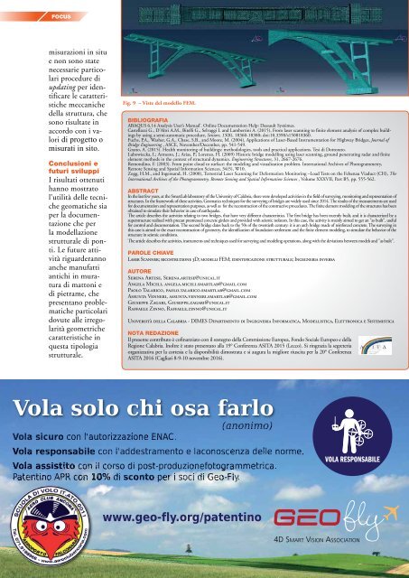
Fig. 9 – Viste del modello FEM.<br />
BIBLIOGRAFIA<br />
ABAQUS 6.14 Analysis User’s Manual’. Online Documentation Help: Dassault Systèmes.<br />
Castellazzi G., D’Altri A.M., Bitelli G., Selvaggi I. and Lambertini A. (2015), From laser scanning to finite element analysis of complex buildings<br />
by using a semi-automatic procedure, Sensors, 15(8), 18360-18380; doi:10.3390/s150818360.<br />
Fuchs, P.A., Washer, G.A., Chase, S.B., and Moore, M. (2004), Applications of Laser-Based Instrumentation for Highway Bridges, Journal of<br />
Bridge Engineering , ASCE, November/December, pp. 541-549.<br />
Grano, A. (2015). Health monitoring of buildings: methodologies, tools and practical applications. Tesi di Dottorato.<br />
Lubowiecka, I.; Armesto, J.; Arias, P.; Lorenzo, H. (2009) Historic bridge modelling using laser scanning, ground penetrating radar and finite<br />
element methods in the context of structural dynamics. Engineering Structures, 31, 2667-2676.<br />
Remondino, F. (2003). From point cloud to surface: the modeling and visualization problem. International Archives of Photogrammetry,<br />
Remote Sensing and Spatial Information Sciences, 34(5), W10.<br />
Zogg, H.M., and Ingensand, H. (2008), Terrestrial Laser Scanning for Deformation Monitoring –Load Tests on the Felsenau Viaduct (CH), The<br />
International Archives of the Photogrammetry, Remote Sensing and Spatial Information Sciences , Volume XXXVII, Part B5, pp. 555-562.<br />
ABSTRACT<br />
In the last few years, at the SmartLab laboratory of the University of Calabria, there were developed activities in the field of surveying, monitoring and representation of<br />
structures. In the framework of these activities, Geomatics techniques for the surveying of bridges are widely used since 2014. The results of the measurements are used<br />
for documentation and representation purposes, as well as for the reconstruction of the constructive procedures. The finite element modeling of the structures has been<br />
obtained to simulate their behavior in case of earthquake.<br />
The article describes the activities relating to two bridges, that have very different characteristics. The first bridge has been recently built, and it is characterized by a<br />
superstructure realized with precast prestressed concrete girders and provided with seismic isolators. In this case, the activity is mainly aimed to get an "as built", useful<br />
for control and documentation. The second bridge dates back to the 50s of the twentieth century: it is an arch bridge made of reinforced concrete. The surveying in<br />
this case is aimed to the exact reconstruction of geometry, the identification of foundation settlement and the finite element modeling, to simulate the behavior of the<br />
structure in seismic conditions.<br />
The article describes the activities, instruments and techniques used for surveying and modeling operations, along with the deviations between models and "as built".<br />
PAROLE CHIAVE<br />
Laser Scanner; ricostruzione 3D; modelli FEM; identificazione strutturale; Ingegneria inversa<br />
AUTORE<br />
Serena Artese, Serena.artese@unical.it<br />
Angela Miceli, angela.miceli.smartlab@gmail.com<br />
Paolo Talarico, paolo.talarico.smartlab@gmail.com<br />
Assunta Venneri, assunta.venneri.smartlab@gmail.com<br />
Giuseppe Zagari, Giuseppe.zagari@unical.it<br />
Raffaele Zinno, Raffaele.zinno@unical.it<br />
Università della Calabria - DIMES Dipartimento di Ingegneria Informatica, Modellistica, Elettronica e Sistemistica<br />
NOTA REDAZIONE<br />
Il presente contributo è cofinanziato con il sostegno della Commissione Europea, Fondo Sociale Europeo e della<br />
Regione Calabria. Inoltre è stato presentato alla 19° Conferenza ASITA 2015 (Lecco). Si ringrazia la segreteria<br />
organizzativa per la cortesia e la disponibilità dimostrata e si augura la migliore riuscita per la 20° Conferenza<br />
ASITA <strong>2016</strong> (Cagliari 8-9-10 novembre <strong>2016</strong>).<br />
Vola solo chi osa farlo<br />
(anonimo)<br />
Vola sicuro con l'autorizzazione ENAC.<br />
Vola responsabile con l'addestramento e laconoscenza delle norme.<br />
Vola assistito con il corso di post-produzionefotogrammetrica.<br />
Patentino APR con 10% di sconto per i soci di Geo-Fly.<br />
www.geo-fly.org/patentino<br />
VOLA RESPONSABILE<br />
GEOfly<br />
4D SMART VISION ASSOCIATION<br />
10 <strong>GEOmedia</strong> n°4-<strong>2016</strong>


