
You also want an ePaper? Increase the reach of your titles
YUMPU automatically turns print PDFs into web optimized ePapers that Google loves.
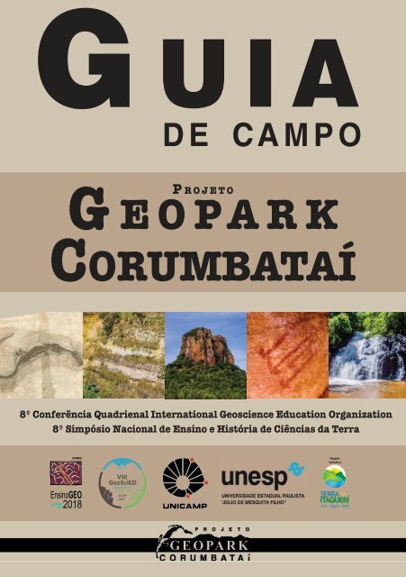
G UIA<br />
DE CAMPO<br />
G<br />
P ROJETO<br />
EOPARK<br />
CORUMBATAÍ<br />
8º Conferência Quadrienal International Geoscience Education Organization<br />
8º Simpósio Nacional <strong>de</strong> Ensino e História <strong>de</strong> Ciências da Terra
Sobre<br />
O Projeto Geopark Corumbataí é<br />
uma iniciativa que visa <strong>de</strong>senvolver<br />
um Geopark na Bacia Hidrográfica<br />
do Rio Corumbataí, interior<br />
do estado <strong>de</strong> São Paulo.<br />
Geopark é um mo<strong>de</strong>lo <strong>de</strong> gestão<br />
que protege e valoriza o<br />
patrimônio natural <strong>de</strong> uma região<br />
por meio <strong>de</strong> estratégias <strong>de</strong><br />
Geoconservação e Geoturismo,<br />
sustentando a cultura local e<br />
promovendo o <strong>de</strong>senvolvimento<br />
sustentável.<br />
About<br />
The Corumbataí Geopark Project<br />
is an initiative that aims to <strong>de</strong>velop<br />
a Geopark in the Corumbataí<br />
River Basin, in the state of São<br />
Paulo.<br />
Geopark is a management mo<strong>de</strong>l<br />
that protects and values the natural<br />
heritage of a region through<br />
geoconservation and geotourism<br />
strategies, sustaining local culture<br />
and promoting sustainable <strong>de</strong>velopment.<br />
Referências<br />
References<br />
FAPESP, 2012 - Pontas <strong>de</strong> um passado remoto. Pesquisa FAPESP: 194,<br />
Online.<br />
Ferreira & Oliveira, 2017 - Sobre um Dia <strong>de</strong> <strong>Campo</strong>: Serra do Itaqueri (SP) -<br />
Expressão Geográfi ca: Online.<br />
Zenai<strong>de</strong> Teles, 2017 - Fotografi as do <strong>Campo</strong> na Serra do Itaqueri<br />
Zaine M. F., 1996 - Patrimônios naturais da região <strong>de</strong> Rio Claro, Ipeúna e<br />
Serra dos Padres. Pós-Doutorado. Rio Claro: Unesp.<br />
<strong>Guia</strong> <strong>de</strong> <strong>Campo</strong> - Geopark Corumbataí - VIII <strong>GeoSciEd</strong> / VIII<br />
EnsinoGEO / André <strong>de</strong> Andra<strong>de</strong> Kolya, Fabíula Moreno Arantes, José<br />
Eduardo Zaine.<br />
Universida<strong>de</strong> Estadual Paulista. Rio Claro, <strong>2018</strong>. 16 f. : il<br />
1. Geodiversida<strong>de</strong>. 2. Geoconservação. 3. Patrimônio Geológico.<br />
4. Geoturismo. 5. Bacia do Paraná.
Geopark Cor<br />
Analândia<br />
Cachoeira<br />
Major Levy<br />
“Major<br />
Levy”<br />
Waterfall<br />
5<br />
Corumbataí<br />
Ipeúna<br />
Rio Claro<br />
2 Afloramento<br />
Três Eras<br />
Three Era Outcrop
Patrimônio<br />
Geológico<br />
umbataíGeoheritage<br />
3<br />
Morros Testemunhos<br />
Hill & Buttes<br />
4 Gruta<br />
1<br />
Toca<br />
Pedreira dos do Índio<br />
Mesossaurí<strong>de</strong>os<br />
Mesosauria Quarry<br />
“Toca do<br />
Índio”<br />
Cave<br />
N<br />
4<br />
3<br />
5<br />
2<br />
Seção Estratigráfica<br />
Stratigraphic section<br />
1<br />
S
Pedreira dos Meso<br />
Mesosauria Quarry<br />
A primeira parada é uma<br />
pedreira <strong>de</strong> argila e calcário<br />
localizada no município <strong>de</strong><br />
Rio Claro. No local, afl oram rochas<br />
sedimentares, <strong>de</strong> ida<strong>de</strong><br />
Permiana, e uma soleira magmática,<br />
<strong>de</strong> ida<strong>de</strong> cretácea.<br />
The field trip will<br />
start at a quarry located<br />
in the city of Rio<br />
Claro. This geosite contains<br />
rocks from two permian stratigraphic<br />
units and a diabase sill,<br />
of cretacian age.<br />
A Formação Irati, em especial,<br />
possui notável valor geopatrimonial,<br />
com <strong>de</strong>staque para os<br />
fósseis <strong>de</strong> Mesossaurí<strong>de</strong>os,<br />
que evi<strong>de</strong>nciam a quebra e<br />
separação do Gondwana.<br />
The Irati Formation displays several<br />
elements geoheritage, such<br />
as mesosauria fossil remains,<br />
due to its scientifi c relevance as<br />
an evi<strong>de</strong>nce of the Continental<br />
Drift and the break-up of Gondwana.<br />
1<br />
Você está aqui<br />
You are here<br />
Rio Claro - SP
sossaurí<strong>de</strong>os<br />
Cenozoico<br />
Cenozoic<br />
Mesozoico<br />
Mesozoic<br />
250 Ma<br />
Paleozoico<br />
Paleozoic<br />
540 Ma<br />
30 Ma<br />
Cretáceo K<br />
Jurássico J<br />
Triássico TR<br />
Permiano P<br />
Carbonífero C<br />
Pré-Cambriano pЄ<br />
15 m<br />
0 m<br />
Formação<br />
Corumbataí<br />
Formação<br />
Irati<br />
Form. Serra Geral<br />
Formação<br />
Irati
Afloramento das T<br />
Three Era Outcrop<br />
O segundo ponto do roteiro<br />
exibe o registro <strong>de</strong> 3 diferentes<br />
Eras geológicas. As unida<strong>de</strong>s<br />
estratigráficas, da base<br />
para o topo, são:<br />
The next site is an<br />
outcrop of rocks from<br />
three geological Eras.<br />
The stratigraphic units, from<br />
bottom to top, are:<br />
1 - Siltitos/argilitos da Formação<br />
Corumbataí (Paleozoico)<br />
2 - Arenitos da Formação<br />
Pirambóia (Mesozoico)<br />
3 - Arenitos da Formação<br />
Rio Claro (Cenozoico)<br />
1 - Siltstone / claystone - Corumbataí<br />
Formation (Paleozoic)<br />
2 - Sandstone - Pirambóia<br />
Formation (Mesozoic)<br />
3 - Sandstone - Rio Claro<br />
Formation (Cenozoic)<br />
2 Você está aqui<br />
You are here<br />
Rio Claro - SP
Três Eras<br />
Cenozoico<br />
Cenozoic<br />
Mesozoico<br />
Mesozoic<br />
250 Ma<br />
Paleozoico<br />
Paleozoic<br />
540 Ma<br />
25 m<br />
30 Ma Formação<br />
Cretáceo K<br />
Rio Claro<br />
Jurássico J<br />
Triássico TR<br />
Permiano P<br />
Carbonífero C<br />
Pré-Cambriano pЄ<br />
0 m<br />
Formação<br />
Pirambóia<br />
Formação<br />
Corumbataí
Cuesta e Morros T<br />
Hill and Buttes<br />
O próximo ponto é no município<br />
<strong>de</strong> Analândia, região <strong>de</strong><br />
cuestas, on<strong>de</strong> estão as nascentes<br />
do rio Corumbataí.<br />
No local, existem dois conhecidos<br />
morros testemunhos<br />
(Cuscuzeiro e Camelo) que<br />
ilustram a evolução<br />
geomorfológica da região.<br />
Sustentadas pelo basalto (Formação<br />
Serra Geral), as escarpas<br />
expõem afloramentos <strong>de</strong><br />
arenitos eólicos da Formação<br />
Botucatu (Juro-Cretáceo).<br />
The next stop is in<br />
the city of Analândia,<br />
a cliffs’ region, where the<br />
sources of the Corumbataí<br />
river are located. Two well<br />
known Buttes can be seen (“Couscous”<br />
and “Camel”) and interpreted<br />
as results of the geomophologycal<br />
evolution.<br />
Held by igneous Basalt from the<br />
“Serra Geral” Formation, the Plateau<br />
cliffs exhibit magnifi cent outcrops of<br />
eolian sandstones from the “Botucatu”<br />
Formation (Juro-Cretaceous of<br />
the Paraná Basin).<br />
3 Você está aqui<br />
You are here<br />
Analândia - SP
Testemunhos<br />
Cenozoico<br />
Cenozoic<br />
Mesozoico<br />
Mesozoic<br />
250 Ma<br />
Paleozoico<br />
Paleozoic<br />
540 Ma<br />
30 Ma<br />
Cretáceo K<br />
Jurássico J<br />
Triássico TR<br />
Permiano P<br />
Carbonífero C<br />
Pré-Cambriano pЄ<br />
Form.<br />
Itaqueri<br />
Form.<br />
Serra<br />
Geral<br />
Form.<br />
Botucatu<br />
Form.<br />
Pirambóia
Caverna Toca do Í<br />
“Toca do Índio” Cave<br />
As cuestas areníticas do<br />
Geopark Corumbataí possuem<br />
diversas cavida<strong>de</strong>s naturais<br />
formadas pela erosão.<br />
Algumas <strong>de</strong>stas foram utilizadas<br />
pelas populações que estiveram<br />
na região nos últimos<br />
milhares <strong>de</strong> anos.<br />
A Caverna “Toca do Índio”,<br />
próximo ponto <strong>de</strong> parada se<br />
<strong>de</strong>staca por exibir diversas<br />
pinturas rupestres.<br />
The Sandstone Hills<br />
of the Corumbataí<br />
Geopark host several<br />
natural cavities, formed by<br />
erosion.<br />
Some of them, where used by<br />
communities which had been at the<br />
region at the last few thousand of<br />
years.<br />
The “Toca do Índio” Cave, next<br />
stop, is know for its many prehistoric<br />
paintings.<br />
4 Você está aqui<br />
You are here<br />
Analândia - SP
Índio<br />
Gruta<br />
Pinturas<br />
Rupestes<br />
N<br />
A<br />
B<br />
Boca A<br />
10 m<br />
Boca B
Cachoeira Major L<br />
“Major Levy” Waterfall<br />
O último ponto é uma cachoeira,<br />
on<strong>de</strong> o Rio Corumbataí<br />
transpõe uma soleira <strong>de</strong><br />
diabásio da Formação Serra<br />
Geral (K).<br />
The last point is a waterfall,<br />
where the Corumbataí<br />
River transposes a<br />
diabase sill of the Serra Geral<br />
Formation (K).<br />
As soleiras <strong>de</strong> diabásio são<br />
parte <strong>de</strong> um dos maiores<br />
eventos <strong>de</strong> magmatismo do<br />
planeta, relacionado à quebra<br />
do Gondwana.<br />
The diabase sills are a part of one<br />
of the largest magmatism events on<br />
the planet, related to the Gondwana<br />
break.<br />
5 Você está aqui<br />
You are here<br />
Analândia - SP
Levy
Serra do<br />
Cuscuzeiro<br />
Itirapina<br />
Rio Claro<br />
Charqueada<br />
Piracicaba<br />
a