Folded Map: Louisville Street Map
Folded Map: Louisville Street Map
Folded Map: Louisville Street Map
- TAGS
- folded
- louisville
- street

Create successful ePaper yourself
Turn your PDF publications into a flip-book with our unique Google optimized e-Paper software.
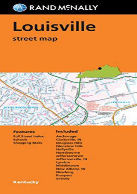
<strong>Folded</strong> <strong>Map</strong>: <strong>Louisville</strong> <strong>Street</strong> <strong>Map</strong> (Rand McNally) Rand McNally s folded map for <strong>Louisville</strong> is a must-have for anyone traveling in and around this part of Kentucky, offering unbeatable accuracy and reliability at a great price. Our trusted cartography shows all Interstate, U.S., state, and county highways, along with clearly indicated parks, points of interest, airports, county boundaries, and streets. The easy-to-use legend and detailed index make for quick and easy location of destinations. You ll see why Rand McNally folded maps have been the trusted standard for years. Regularly updated Full-color maps Clearly labeled Interstate, U.S., state, and county highways Indications of parks, points of interest, airports, schools, shopping malls, county boundaries, downtown &vicinity maps Easy-to-use legend Detailed &full street index Convenient folded size Copyright 2016Coverage AreaCommunities Included: Achorage, Clarksville, IN, Douglass Hills, Glenview Hills, Hollyvilla, Hurtsbourne, Jeffersontown, Jeffersonville, IN, Lyndon, Middletown, New Albany, IN, Newburg, Prospect, ShivelyProduct DetailsMeasures 9.5 x 4 and folds out to 40 x 28 .<br />
<strong>Folded</strong> <strong>Map</strong>: <strong>Louisville</strong> <strong>Street</strong> <strong>Map</strong>

![White Mountain National Forest West [Franconia Notch, Lincoln] (National Geographic Trails Illustrated Map)](https://img.yumpu.com/59273974/1/184x260/white-mountain-national-forest-west-franconia-notch-lincoln-national-geographic-trails-illustrated-map.jpg?quality=85)
![White Mountain National Forest [Map Pack Bundle] (National Geographic Trails Illustrated Map)](https://img.yumpu.com/59273972/1/184x260/white-mountain-national-forest-map-pack-bundle-national-geographic-trails-illustrated-map.jpg?quality=85)
![Pisgah Ranger District [Pisgah National Forest] (National Geographic Trails Illustrated Map)](https://img.yumpu.com/59273970/1/184x260/pisgah-ranger-district-pisgah-national-forest-national-geographic-trails-illustrated-map.jpg?quality=85)

![Fontana and Hiwassee Lakes [Nantahala National Forest] (National Geographic Trails Illustrated Map)](https://img.yumpu.com/59273966/1/184x260/fontana-and-hiwassee-lakes-nantahala-national-forest-national-geographic-trails-illustrated-map.jpg?quality=85)


![United States Decorator [Tubed] (National Geographic Reference Map)](https://img.yumpu.com/59273960/1/184x260/united-states-decorator-tubed-national-geographic-reference-map.jpg?quality=85)