

pgou anexos - Castejon de Monegros
pgou anexos - Castejon de Monegros
pgou anexos - Castejon de Monegros

You also want an ePaper? Increase the reach of your titles
YUMPU automatically turns print PDFs into web optimized ePapers that Google loves.
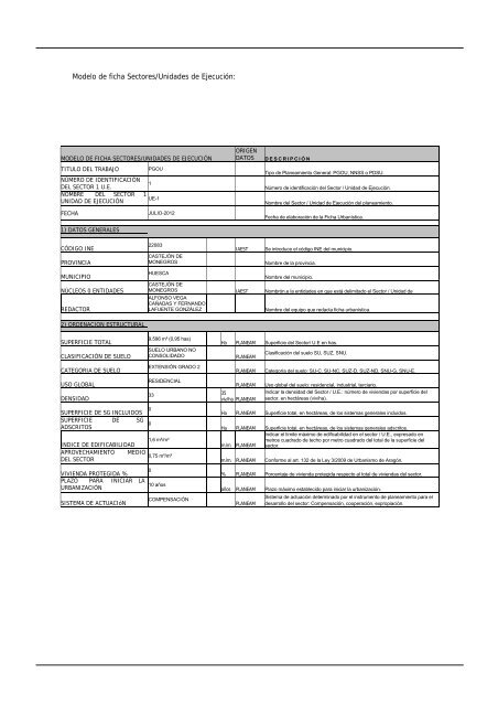
Mo<strong>de</strong>lo <strong>de</strong> ficha Sectores/Unida<strong>de</strong>s <strong>de</strong> Ejecución:<br />
MODELO DE FICHA SECTORES/UNIDADES DE EJECUCIÓN<br />
TITULO DEL TRABAJO PGOU<br />
NÚMERO DE IDENTIFICACIÓN<br />
DEL SECTOR 1 U.E.<br />
1<br />
NOMBRE DEL SECTOR<br />
UNIDAD DE EJECUCIÓN<br />
1<br />
UE-1<br />
FECHA JULIO-2012<br />
1) DATOS GENERALES<br />
CÓDIGO INE<br />
PROVINCIA<br />
MUNICIPIO<br />
NÚCLEOS 0 ENTIDADES<br />
REDACTOR<br />
2) ORDENACION ESTRUCTURAL<br />
SUPERFICIE TOTAL<br />
CLASIFICACIÓN DE SUELO<br />
CATEGORIA DE SUELO<br />
USO GLOBAL<br />
DENSIDAD<br />
SUPERFICIE DE SG INCLUIDOS 0<br />
SUPERFICIE<br />
ADSCRITOS<br />
DE SG<br />
0<br />
22083<br />
CASTEJÓN DE<br />
MONEGROS<br />
HUESCA<br />
CASTEJÓN DE<br />
MONEGROS<br />
ALFONSO VEGA<br />
CAÑADAS Y FERNANDO<br />
LAFUENTE GONZÁLEZ<br />
9.596 m² (0,95 has)<br />
SUELO URBANO NO<br />
CONSOLIDADO<br />
EXTENSIÓN GRADO 2<br />
RESIDENCIAL<br />
1,6 m²/m²<br />
INDICE DE EDIFICABILIDAD<br />
APROVECHAMIENTO MEDIO<br />
0,75 m²/m²<br />
DEL SECTOR<br />
VIVIENDA PROTEGIDA %<br />
0<br />
PLAZO PARA<br />
URBANIZACIÓN<br />
INICIAR LA<br />
10 años<br />
SISTEMA DE ACTUACIóN<br />
ORIGEN<br />
DATOS DESCRIPCIÓN<br />
Tipo <strong>de</strong> Planeamiento General: PGOU, NNSS o PDSU.<br />
Número <strong>de</strong> i<strong>de</strong>ntificación <strong>de</strong>l Sector / Unidad <strong>de</strong> Ejecución.<br />
Nombre <strong>de</strong>l Sector / Unidad <strong>de</strong> Ejecución <strong>de</strong>l planeamiento.<br />
Fecha <strong>de</strong> elaboración <strong>de</strong> la Ficha Urbanística.<br />
IAEST Se introduce el código INE <strong>de</strong>l municipio.<br />
Nombre <strong>de</strong> la provincia.<br />
Nombre <strong>de</strong>l municipio.<br />
IAEST Nombrón.e la entida<strong>de</strong>s en que está <strong>de</strong>limitado el Sector / Unidad <strong>de</strong><br />
Nombre <strong>de</strong>l equipo que redacta ficha urbanística.<br />
Ha PLANEAM Superficie <strong>de</strong>l Sector/ U.E en has.<br />
PLANEAM<br />
33 35<br />
viv/ha PLANEAM<br />
COMPENSACIÓN<br />
Clasificación <strong>de</strong>l suelo SU, SUZ, SNU.<br />
PLANEAM Categoría <strong>de</strong>l suelo: SU-C, SU-NC, SUZ-D, SUZ-ND, SNU-G, SNU-E.<br />
PLANEAM Uso global <strong>de</strong>l suelo: resi<strong>de</strong>ncial, industrial, terciario.<br />
Indicar la <strong>de</strong>nsidad <strong>de</strong>l Sector / U.E.: número <strong>de</strong> viviendas por superficie <strong>de</strong>l<br />
sector, en hectáreas (viv/ha).<br />
Ha PLANEAM Superficie total, en hectáreas, <strong>de</strong> los sistemas generales incluidos.<br />
Ha PLANEAM Superficie total, en hectáreas, <strong>de</strong> los sistemas generales adscritos.<br />
Indicar el límite máximo <strong>de</strong> edificabilidad en el sector / U.E., expresado en<br />
metros cuadrado <strong>de</strong> techo por metro cuadrado <strong>de</strong>l total <strong>de</strong> la superficie <strong>de</strong>l<br />
mzlmz PLANEAM sector.<br />
mzlmz PLANEAM Conforme al art. 132 <strong>de</strong> la Ley 3/2009 <strong>de</strong> Urbanismo <strong>de</strong> Aragón.<br />
% PLANEAM Porcentaje <strong>de</strong> vivienda protegida respecto al total <strong>de</strong> viviendas <strong>de</strong>l sector.<br />
años PLANEAM Plazo máximo establecido para iniciar la urbanización.<br />
Sistema <strong>de</strong> actuación <strong>de</strong>terminado por el instrumento <strong>de</strong> planeamiento para el<br />
PLANEAM <strong>de</strong>sarrollo <strong>de</strong>l sector: Compensación, cooperación, expropiación.